Sediment management plans in French mountainous catchments with illustrations from emblematic projects Dr. Benoit Terrier
|
|
|
- Ezra Cross
- 5 years ago
- Views:
Transcription

1 Sediment management plans in French mountainous catchments with illustrations from emblematic projects Dr. Benoit Terrier Agence de l Eau Rhône Méditerranée et Corse, FRANCE
2 Presentation layout 1. The context surrounding sediment management in France and in the Rhone catchment in particular 2. Three examples of (not always quite emblematic) projects in France in terms of sediment management 3. Short statements on: i. Policy framework concerning sediment management in France ii. Sediment monitoring (enough, gaps?) iii. Gaps in sediment management that require further research
 => Many of the catchments for which sediment")
3 Sediment management in the Rhone catchment On the Rhone and mediterranean catchment: 2/3 rd of rivers have hydromorphological alterations 60% among them have an altered hydrological regime 70% among them have their biological and sediment transport continuity disrupted by weirs or dams 70% have an altered morphology (reshaping of main channel etc ) => Many of the catchments for which sediment management represent the greatest challenge are located in mountainous regions Catchments identified with issues linked to sediment
4 Measures prescribed to reach good ecological status Several measures have been prescribed to tackle issues related to sediment in order to reach good ecological status (Rhone catchment) Manage sediment transport and the longitudinal profile Improve the management of floods (frequency, duration and peak flow) in favour of morphogenic floods (measure 3C06) Remove or adapt weirs or dams that alter sediment transport continuity (list all structures, lower the structures 3C07) Take action to improve the management of structures altering sediment transport (3C09) Limit or stop negative sediment fluxes (e.g. prevent sand fluxes3c37) Set up a sediment replenishment plan (3C32) => 5 measures that require studies to define the right actions to be applied
5 French Policy framework concerning sediment management Legal requirement to publish a list of rivers for which it is necessary to reestablish sufficient sediment transport and fish migration Two lists of rivers identified: List I: rivers in very good ecological status (preserve) List II: rivers for which work is required It is a legal requirement to intervene before 2017 on identified structures (dams and weirs mainly) which are located on rivers in list II. To encourage action, around 780 structures were identified and divided into 2 categories on the Rhone catchment. Actions are partly subsidised for owners (from 50% to 80%) until Category I: needs to dealt with in 2012 Category II: at least some studies for 2012 and dealt with in 2017
6 Sediment management in the Rhone catchment Main types of restoration projects related to sediment: Dam/weir removal, with clear targets and deadlines on identified structures (many examples) Sediment replenishing (from lateral sources, taking sediment u/s of a dam and re-injecting it further d/s) few cases Setting up of a low bottom weirs to stabilise the longitudinal profile, reshaping an altered main channel to a more natural state Setting back flood defences (few cases) / reconnecting oxbows Organise flushing of dams / gate operations (few cases) etc
7 Sediment management in the Rhone catchment Three restoration projects related to sediment 1. River Ain 2. River Durance 3. River Fontaulière


, promote")
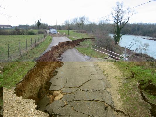
8 River Ain project (1/6) Issues: 5 large upstream dams for hydroelectricity, gravel extractions and bank protection => incised river bed, erratic lateral erosion But: the river Ain has potential to be dynamic downstream of the dams The project: bring back to dynamism the river (mainly by lateral recharge), promote sediment transport where possible (1.7M ) Steering group


9 Managing the erodible corridor (2/6)

10 Analysis of granulometry (3/6) Pont d Ain Priay Gévrieux Mollon Armoured area Armouring happening Charnoz Coarse sediment St Maurice de Gourdans


11 Sediment budget evaluation (4/6) Pont d Ain Incoming from river Albarine Channel incision Channel deposition Priay Incoming from upstream Outgoing into the river Rhone Gévrieux Mollon Storage in river banks Storage in floodplain Significant sediment sources Sediment sources Storage area Charnoz St Maurice de Gourdans Significant storage area


12 Sediment management scenarios


13 Sediment refilling and oxbow restoration (6/6)

14 River Durance project (1/6) Dam flushing to mitigate silting of the river bed ex: Flushing operations at the Saulce dam Reason for flushing operations: Between Serre-Ponçon and Sisteron, generalised silting of the river bed due to reduced flows and fine sediment inputs from tributaries and catchments =>Ecological value of the reach is very much decreased The river Durance in 2007 during a flushing operation

")


15 River Durance project (2/6)
16 River Durance project (3/6) Experimental approach: =>Finding the right flow rate and the right duration of the event In 18th Sept 2007: Q=80m 3 /s for 10 hours, increased by steps Monitoring with initial state and measures soon after the event (5 sites, 3 cross-sections per site): Topography, river patterns (pools and riffles sequences), granulometry, measure of siltation Biological Index Fish Monitoring the following months to evaluate the time taken to come back to the initial state


 Before and during the dam flushing Silt in")
17 River Durance project (4/6) Conclusions for 2007: 80m 3 /s is enough to clean superficial silting but maybe too high as it leads to local overbank flow Substantial gain in terms of de-silting No adverse effects found on invertebrates and fish A few months after the operation, siltation goes back to the initial state (length of time dependant on hydrology) Before and during the dam flushing Silt in an oxbow
18 River Durance project (5/6) In 2009: 3 monitoring sites instead of 5, 60m3/s instead of 80m3/s Results 60m 3 /s high enough flow rate to clean superficial silting However, the relative gain in terms of de-silting is lower compared to 2007 (but initial state had higher levels of siltation) The gain is more visible in areas of higher velocities but is it good enough to significantly improve overall ecological conditions?
19 River Durance project (6/6) In 2010: 60m 3 /s twice in the year Results Confirm that 60m 3 /s high enough flow rate to clean superficial silting Gain two levels in terms of degree of silting in the Cemagref protocole However, silting levels go back to initial state after about three months Ecological gain not obvious yet after 4 years What next: retest the other flow rates and several flushing events per year (while avoiding the february-may period due to fish reproduction)


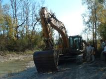
20 River Fontauliere project (1/3) Dam with storage capacity of m 3 Original purpose of the dam: water supply during draughts to people Capacity reduced by 1/3rd due to sediment build up Objectives: 1. Remove 45000m 3 of material (done last summer) to regain storage capacity 2. Re-inject sediment downstream of the dam to heal the incised bed. Originally the dam owner (private owner) wanted to sell the dredged material to the construction industry but the law on aquatic habitat in France now forbids it Removal of material

")

21 River Fontauliere project (2/3) Removal of the dredged material in 2011
22 River Fontauliere project (3/3) Re-injecting sediment downstream of the dam: what is the best option to do it? Where? Which quantity and in how many times? There is little experience in France yet on that topic. A few projects are about to start in the next couple of years (River Tet, 50000m 3 of dredged material, River Drac, 15000m 3 of dredged material ) Experience so far was done on re-injecting small volumes of material to see what the rivers can do There is a great deal of fear from local inhabitant s (flood, environmental impacts ) => A great deal of communication is needed to launch these projects
23 Brief statements (1/5) Policy framework concerning sediment management in France The issue is clearly identified in France since the law imposes the re-establishment of sufficient sediment transport => we aim for an identified result But there are technical questions in terms of priority (identification of the most affected reaches at stakes), how to tackle the issue and the project evaluation (monitoring)
24 Brief statements (2/5) Sediment monitoring (enough, gaps?) 1/2 Clearly there are gaps in terms of sediment monitoring The Water catchment Agencies together with ONEMA launched a network of sites selected to monitor the impacts of river restorations monitor biological parameters (related to fish and macroinvertebrates), water quality and hydromorphological parameters an initial state and a monitoring for up to 6 years after restoration 12 sites were selected in the Rhone catchment, 8 of them are in mountainous catchments with sediment related issues In parallel, a protocol to ensure minimum monitoring was developed and sent to many local river organisations to promote monitoring for project evaluation
25 Brief statements (3/5) Sediment monitoring (enough, gaps?) 2/2 Partnering between researchers and Water catchment Agency Together with researchers from Cemagref, we set up 2 research programs : _to develop a protocol in terms of direct sediment transport management _to investigate the use of Lidar to monitor bar migrations, changes to river reaches, evaluate bars morphometry
26 Brief statements (4/5) Gaps in sediment management that require further research when do we need to intervene on a river to remove sediment built up when there is a risk of flooding / when should we let the river do the job / how to build relevant cost benefits analysis? how will the river respond to dam/weir removal (impacts on groundwater, river bed evolution etc ) how to design sediment reinjection projects? what can sediment transport modelling really bring from an operational viewpoint? When is it really worth doing?


27 Brief statements (5/5) Gaps in sediment management that require further research What do we do of the braided rivers left in the catchment? => Research project to identify the braided rivers and their trajectories in terms of fluvial style (stable or not)
28 Thank you for your attention Agence de l Eau Rhône Méditerranée et Corse
29 River Ouvèze project Project background: Deficit in terms of sediment supply due to u/s dams Former gravel extractions led to incised river bed There is no susbtrate left on the river bed as the water flows directly over bedrock The river bed had been reshaped for flood alleviation purpose The groundwater table has lowered Project objectives: To promote stabilisation of river bed and new susbrate To minimise flood risk impacts To allow for fish migration
30 River Ouvèze project Project description: Pilote reach of 1km where bed level is raised by 0.4m up to 1.4m where the effects of incision are worst. Set up 4 bottom weirs to stabilise the river bed, retain substrate while allowing for fish migration Reshape the river bed to give «more» natural channel dimensions (find former plane forms)

31 River Ouvèze project
32 River Isere project Background project: At first, a serious flooding issue The river had also gone through severe hydromorphological pressures (many gravel extraction sites) which led to some severe incision In France the link between flood issues and river restoration is far from obvious. Only in rare cases like on this project do we see opportunities in flood related projects to promote river restoration Our water Agency tries to encourage ecological inputs by incentive funding
33 River Isere project Project targeting 40km of the Isere river: Flood management plan to ensure 1/200 flood defence level (by making more space to water, setting back flood defences) Ensure river restoration and promote tributaries reconnection (restore lost tributaries and former gravel extraction sites ) Target sediment transport equilibrium (removal 8 weirs)
34 River Isere project Flood management plan to ensure 1/200 flood defence level (by making more space to water, setting back flood defences) Current areas at risk of flooding New controled flooded areas

35 River Isere project Ecological input to the project 300 ha of alluvial forests 8 former gravel extraction sites restored 3 valued natural areas 7 reconnexions piscicoles
36 River Isere project Total cost of actions: 95 M, from which the environmental parts represent 20M Subsidies from the Water catchment agency : 8.5M Project schedule:
Strategies for managing sediment in dams. Iwona Conlan Consultant to IKMP, MRCS
 Strategies for managing sediment in dams Iwona Conlan Consultant to IKMP, MRCS 1 Sediment trapping by dams Active storage capacity Dead storage coarse material (bed load) Fine materials (suspension) Francis
Fact sheet: Glacial rivers (all Europe)
") Fact sheet: Glacial rivers (all Europe) General description Valleyplanform Hydrology and The valley form varies from a gorge to a V-shaped valley and the single-thread channel is mainly characterized by
Fact sheet: Glacial rivers (all Europe) General description Valleyplanform Hydrology and The valley form varies from a gorge to a V-shaped valley and the single-thread channel is mainly characterized by
Upper Drac River restoration project
 Upper Drac River restoration project Restoration of a braided river bed incised in clay substratum through sediment reloading and bed widening SHF Conference, Nantes, 6 & 7 october 2014 Small scale morphological
The River Restoration Centre therrc.co.uk. Understanding Fluvial Processes: supporting River Restoration. Dr Jenny Mant
 The River Restoration Centre therrc.co.uk Understanding Fluvial Processes: supporting River Restoration Dr Jenny Mant Jenny@therrc.co.uk Understanding your catchment Hydrology Energy associated with the
Managing sediment continuity at hydropower dams : conceptual and operational approach
 Workshop 2 : Planning, managing and restoring hydromorphology at river basin scale, within an ecosystem services framework Managing sediment continuity at hydropower dams : conceptual and operational approach
SCOPE OF PRESENTATION STREAM DYNAMICS, CHANNEL RESTORATION PLANS, & SEDIMENT TRANSPORT ANALYSES IN RELATION TO RESTORATION PLANS
 DESIGN METHODS B: SEDIMENT TRANSPORT PROCESSES FOR STREAM RESTORATION DESIGN PETER KLINGEMAN OREGON STATE UNIVERSITY CIVIL ENGINEERING DEPT., CORVALLIS 2 ND ANNUAL NORTHWEST STREAM RESTORATION DESIGN SYMPOSIUM
Step 5: Channel Bed and Planform Changes
 Step 5: Channel Bed and Planform Changes When disturbed, streams go through a series of adjustments to regain equilibrium with the flow and sediment supply of their watersheds. These adjustments often
Why Geomorphology for Fish Passage
 Channel Morphology - Stream Crossing Interactions An Overview Michael Love Michael Love & Associates mlove@h2odesigns.com (707) 476-8938 Why Geomorphology for Fish Passage 1. Understand the Scale of the
Project Proposal. Lyme Brook. Newcastle-under-Lyme. 3 rd July 2015
 Project Proposal Lyme Brook Newcastle-under-Lyme 3 rd July 2015 Contents Page 1.0 Introduction... 1.0 2.0 Background and rationale... 2.0 3.0 Proposed measures... 5 4.0 Summary of Recommendations... 10
Influence of dam removal and past sediment mining on river morphology and biology: example of the Vienne River (France)
") Université François Rabelais de Tours, CNRS/INSU - UMR 6113 CETU Elmis Influence of dam removal and past sediment mining on river morphology and biology: example of the Vienne River (France) S. Rodrigues,
Université François Rabelais de Tours, CNRS/INSU - UMR 6113 CETU Elmis Influence of dam removal and past sediment mining on river morphology and biology: example of the Vienne River (France) S. Rodrigues,
Dam Removal Analysis Guidelines for Sediment
 A review of: Dam Removal Analysis Guidelines for Sediment Joe Rathbun (Retired) rathbunj@sbcglobal.net Some Potential Sediment Issues Reservoir restoration Downstream water quality Downstream deposition
Birch Creek Geomorphic Assessment and Action Plan
 Birch Creek Geomorphic Assessment and Action Plan Jim Webster Tim Hanrahan, PhD, CFM Jesse Schwartz, PhD Zach Hill January 22, 2015 White Eagle Grange This Project is a First Step in Strategy Planning
Business. Meteorologic monitoring. Field trip? Reader. Other?
 Business Meteorologic monitoring Field trip? Reader Other? Classification Streams Characterization Discharge measurements Why classify stream channels? Why Classify Stream Channels? Provides a common language
Stream Restoration and Environmental River Mechanics. Objectives. Pierre Y. Julien. 1. Peligre Dam in Haiti (deforestation)
") Stream Restoration and Environmental River Mechanics Pierre Y. Julien Malaysia 2004 Objectives Brief overview of environmental river mechanics and stream restoration: 1. Typical problems in environmental
Stream Restoration and Environmental River Mechanics Pierre Y. Julien Malaysia 2004 Objectives Brief overview of environmental river mechanics and stream restoration: 1. Typical problems in environmental
Do you think sediment transport is a concern?
 STREAM RESTORATION FRAMEWORK AND SEDIMENT TRANSPORT BASICS Pete Klingeman 1 What is Your Restoration Project Like? k? Do you think sediment transport is a concern? East Fork Lewis River, WA Tidal creek,
Geomorphology. considerations
 Environmental Flows Geomorphology considerations Dr Beevers, Heriot Watt University: Dr A Crosato UNESCO IHE Hydraulics Summary Water components important for ecology etc (depth, velocity, innundation
Opportunities to Improve Ecological Functions of Floodplains and Reduce Flood Risk along Major Rivers in the Puget Sound Basin
 Opportunities to Improve Ecological Functions of Floodplains and Reduce Flood Risk along Major Rivers in the Puget Sound Basin Christopher Konrad, US Geological Survey Tim Beechie, NOAA Fisheries Managing
6.11 Naas River Management Unit
 6.11 Naas River Management Unit 6.11.1 Site 41 Issue: Bed and bank erosion Location: E 0685848 N 6058358 Waterway: Naas River Management Unit: Naas River Facing downstream from Bobeyan Rd bridge Facing
Stream Geomorphology. Leslie A. Morrissey UVM July 25, 2012
 Stream Geomorphology Leslie A. Morrissey UVM July 25, 2012 What Functions do Healthy Streams Provide? Flood mitigation Water supply Water quality Sediment storage and transport Habitat Recreation Transportation
24.0 Mineral Extraction
 Chapter 24 - Mineral Extraction 24.0 Mineral Extraction 24.1 Introduction Apart from gravel, sand, rock, limestone and salt extraction in relatively small quantities mineral extraction is not a strong
ADDRESSING GEOMORPHIC AND HYDRAULIC CONTROLS IN OFF-CHANNEL HABITAT DESIGN
 ADDRESSING GEOMORPHIC AND HYDRAULIC CONTROLS IN OFF-CHANNEL HABITAT DESIGN Conor Shea - Hydrologist U.S. Fish and Wildlife Service Conservation Partnerships Program Arcata, CA Learning Objectives Examine
Wetland & Floodplain Functional Assessments and Mapping To Protect and Restore Riverine Systems in Vermont. Mike Kline and Laura Lapierre Vermont DEC
 Wetland & Floodplain Functional Assessments and Mapping To Protect and Restore Riverine Systems in Vermont Mike Kline and Laura Lapierre Vermont DEC NWI+ Hydro-Geomorphic Characterization of Wetlands and
The SedAlp Project: WP6: INTERACTION WITH STRUCTURES
 The SedAlp Project: WP6: INTERACTION WITH STRUCTURES 6 th International conference Water in the Alps Herrenchiemsee, 12 th of October, 2016 Jošt Sodnik Contents Structure of SedAlp project (www.sedalp.eu)
HAW CREEK, PIKE COUNTY, MISSOURI-TRIB TO SALT RIVER ERODING STREAM THREATHENING COUNTY ROAD #107, FOURTEEN FT TALL ERODING BANK WITHIN 4 FT OF THE
 HAW CREEK, PIKE COUNTY, MISSOURI-TRIB TO SALT RIVER ERODING STREAM THREATHENING COUNTY ROAD #107, FOURTEEN FT TALL ERODING BANK WITHIN 4 FT OF THE ROAD, PROJECT CONSTRUCTED IN 1 DAY, MARCH 10, 2009 BY
Identifying, Understanding and Addressing Flood-Related Hazards
 Identifying, Understanding and Addressing Flood-Related Hazards Julie Moore, P.E. July 9, 2012 Agenda Traditional approach to river management Understanding flood-related hazards Common flood and flood
Stream Simulation: A Simple Example
 Stream Simulation: A Simple Example North Thompson Creek, CO Paul T. Anderson U.S.D.A. Forest Service Here s How We Started May 2011 2-1 USDA-Forest Service Here s How We Finished Forest Service Aquatic
The Danube River. Hydrological Connectivity and Human Influence. By: Pat O Connell, Pat Wilkins, Tiana Royer, and Kevin Gaitsch
 The Danube River Hydrological Connectivity and Human Influence By: Pat O Connell, Pat Wilkins, Tiana Royer, and Kevin Gaitsch Danube River Characteristics Length: 2860 km Drainage Area: 816,000 km 2 Peak
Restoring river-floodplain interconnection and riparian habitats along the embanked Danube between Neuburg and Ingolstadt (Germany)
") Restoring river-floodplain interconnection and riparian habitats along the embanked Danube between Neuburg and Ingolstadt (Germany) Dipl.-Geogr. Gerald Blasch Department of Physical Geography, Cath. University
Restoring river-floodplain interconnection and riparian habitats along the embanked Danube between Neuburg and Ingolstadt (Germany) Dipl.-Geogr. Gerald Blasch Department of Physical Geography, Cath. University
APPENDIX E. GEOMORPHOLOGICAL MONTORING REPORT Prepared by Steve Vrooman, Keystone Restoration Ecology September 2013
 APPENDIX E GEOMORPHOLOGICAL MONTORING REPORT Prepared by Steve Vrooman, Keystone Restoration Ecology September 2 Introduction Keystone Restoration Ecology (KRE) conducted geomorphological monitoring in
The Effects of Geomorphology and Watershed Land Use on Spawning Habitat
 The Effects of Geomorphology and Watershed Land Use on Spawning Habitat By Evan Buckland INTRODUCTION The distribution and frequency of large geomorphic features in a watershed govern where suitable spawning
Lower South Fork McKenzie River Floodplain Enhancement Project
 Lower South Fork McKenzie River Floodplain Enhancement Project McKenzie River Ranger District Willamette National Forest Project Location The project is located in the South Fork McKenzie River Watershed,
Why Stabilizing the Stream As-Is is Not Enough
 Why Stabilizing the Stream As-Is is Not Enough Several examples of alternatives to the County s design approach have been suggested. A common theme of these proposals is a less comprehensive effort focusing
Subcommittee on Sedimentation Draft Sediment Analysis Guidelines for Dam Removal
 Subcommittee on Sedimentation Draft Sediment Analysis Guidelines for Dam Removal August 4, 2011 Jennifer Bountry, M.S., P.E. Tim Randle, M.S., P.E., D.WRE. Blair Greimann, Ph.D., P.E. Sedimentation and
How to predict the sedimentological impacts of reservoir operations?
 ICSE 212 How to predict the sedimentological impacts of reservoir operations? E. Valette EDF CIH eric.valette@edf.fr M. Jodeau EDF R&D LNHE magali.jodeau@edf.fr Presentation of the numerical code Courlis
Restoring Meanders to Straightened Rivers 1.7 Reconnecting remnant meanders
 .7 Reconnecting remnant meanders River Little Ouse Location - Thetford, Norfolk TL87082 Date of construction - 994 Length 900m Cost 5,000 Maximum extent of flooding during winter floods BTO boundary Small
Technical Memorandum No
 Pajaro River Watershed Study in association with Technical Memorandum No. 1.2.10 Task: Evaluation of Four Watershed Conditions - Sediment To: PRWFPA Staff Working Group Prepared by: Gregory Morris and
Gully Erosion Part 1 GULLY EROSION AND ITS CAUSES. Introduction. The mechanics of gully erosion
 Gully Erosion Part 1 GULLY EROSION AND ITS CAUSES Gully erosion A complex of processes whereby the removal of soil is characterised by incised channels in the landscape. NSW Soil Conservation Service,
DAM REMOVAL ENGINEERING ISSUES & OPTIONS
 DAM REMOVAL ENGINEERING ISSUES & OPTIONS Presented by: James G. Mac Broom, P.E. Milone & Mac Broom, Inc. October 2011 CLEAR GOALS and OBJECTIVES Fish Passage Habitat Defragmentation Water Quality Dam Failure
The Hydrologic Cycle STREAM SYSTEMS. Earth s Water and the Hydrologic Cycle. The Hydrologic Cycle. Hydrologic Cycle
 STREAM SYSTEMS Earth Science: Chapter 5 Reading pages 114-124 The Hydrologic Cycle Oceans not filling up Evaporation = precipitation System is balanced Earth s Water and the Hydrologic Cycle Earth s Water
Flooding in Dolgellau
 Flooding in Dolgellau Graham Hall MMath, PhD University of Wales, Bangor Background Flooding has historically been a cause for concern in Dolgellau. Following a serious flood in December 1964 when shops
The RRC would like to thank the sponsors of the RRC Annual Conference 2015 who support discounted places
 16 TH ANNUAL NETWORK CONFERENCE Tweet us using #RRC2015 People and Process-Based River Management: Restoring River Processes; Natural Flood Management; Healthy Catchments The RRC would like to thank the
Final Exam. Running Water Erosion and Deposition. Willamette Discharge. Running Water
 Final Exam Running Water Erosion and Deposition Earth Science Chapter 5 Pages 120-135 Scheduled for 8 AM, March 21, 2006 Bring A scantron form A calculator Your 3 x 5 paper card of formulas Review questions
Technical Review of Pak Beng Hydropower Project (1) Hydrology & Hydraulics and (2) Sediment Transport & River Morphology
 Hydrology & Hydraulics and (2) Sediment Transport & River Morphology") Technical Review of Pak Beng Hydropower Project (1) Hydrology & Hydraulics and (2) Sediment Transport & River Morphology The 2 nd Regional Stakeholder Forum The Pak Beng Hydropower Project 5 th May 2017
Technical Review of Pak Beng Hydropower Project (1) Hydrology & Hydraulics and (2) Sediment Transport & River Morphology The 2 nd Regional Stakeholder Forum The Pak Beng Hydropower Project 5 th May 2017
In-channel coarse sediment trap Best Management Practice
 In-channel coarse sediment trap Best Management Practice By Henry R. Hudson July 2002 Environmental Management Associates Ltd., Christchurch Complexity Environmental Value Cost Low Moderate High Low Moderate
ES 105 Surface Processes I. Hydrologic cycle A. Distribution % in oceans 2. >3% surface water a. +99% surface water in glaciers b.
 ES 105 Surface Processes I. Hydrologic cycle A. Distribution 1. +97% in oceans 2. >3% surface water a. +99% surface water in glaciers b. >1/3% liquid, fresh water in streams and lakes~1/10,000 of water
Limitation to qualitative stability indicators. the real world is a continuum, not a dichotomy ~ 100 % 30 % ~ 100 % ~ 40 %
 Stream Stability Assessment & BEHI Surveys Joe Rathbun MDEQ Water Resources Division rathbunj@michigan.gov 517--373 517 373--8868 Stability Stream can transport its water and sediment inputs without changing
Upper Mississippi River Basin Environmental Management Program Workshop
 Presentation to the Upper Mississippi River Basin Environmental Management Program Workshop by Michael Rodgers River Engineer US Army Corps of Engineers, St. Louis District August 17, 2007 Engineering
BUREAU OF CLEAN WATER. Appendix C Biological Field Methods C1. Habitat Assessment DECEMBER 2013
 BUREAU OF CLEAN WATER Appendix C Biological Field Methods C1. Assessment DECEMBER 2013 HABITAT ASSESSMENT The Department has adopted the habitat assessment methods outlined in EPA s Rapid Bioassessment
Physical modeling to guide river restoration projects: An Overview
 Physical modeling to guide river restoration projects: An Overview Scott Dusterhoff¹, Leonard Sklar², William Dietrich³, Frank Ligon¹, Yantao Cui¹, and Peter Downs¹ ¹Stillwater Sciences, 2855 Telegraph
Tarbela Dam in Pakistan. Case study of reservoir sedimentation
 Tarbela Dam in Pakistan. HR Wallingford, Wallingford, UK Published in the proceedings of River Flow 2012, 5-7 September 2012 Abstract Reservoir sedimentation is a main concern in the Tarbela reservoir
Sediment Management for Dam Removals
 Sediment Management for Dam Removals As Presented To: Sediment Management for Dam Removals, A Hands on Workshop on the Latest Techniques for Dam Modification and Removal, Purdue University Calumet, IN,
Dolores River Watershed Study
 CHAPTER 4: RIVER AND FLOODPLAIN ISSUES The Dolores River falls into a category of streams in Colorado that share some unique characteristics. Like some other mountain streams in the state, it has a steep
EBRO DELTA WORK PLAN
 EBRO DELTA Third Workshop on Flood Risk and Danube Delta, September 2011 Albert Rovira & Carles Ibáñez IRTA-Aquatic Ecosystems 0 Ebro Delta Work Plan Main aim is to mitigate the effects of sediment imbalance
Running Water Earth - Chapter 16 Stan Hatfield Southwestern Illinois College
 Running Water Earth - Chapter 16 Stan Hatfield Southwestern Illinois College Hydrologic Cycle The hydrologic cycle is a summary of the circulation of Earth s water supply. Processes involved in the hydrologic
CASE STUDY BINGA, PHILIPPINES
 SEDIMENT MANAGEMENT CASE STUDY BINGA, PHILIPPINES Key project features Name: Binga Country: Philippines Category: modify operating rule (focus or redistribute sediment); adaptive strategies Binga hydropower
Griswold Creek August 22, 2013
 Creek August 22, 2013 1 Lake Erie Protection Fund Creek Study ver Evaluate the overall condition of Creek Determine stable channel dimensions & appropriate restoration techniques Starting Stat gpoint for
APPENDIX A REACH DECRIPTIONS. Quantico Creek Watershed Assessment April 2011
 APPENDIX A REACH DECRIPTIONS Basin 615, South Fork of Quantico Creek - Project Reach Descriptions Reach Name: 615-A Coordinates (NAD 83, Virginia State Plane North): 11796510.57, 6893938.95 to 11801555.79,
Licca Liber - the free Lech
 Licca Liber - the free Lech Source: W. Schilling WWA Donauwörth The river Lech an overview Hydrography / Hydrology catchment area 4000 km² Length 256 km Delta H 1100 m Slope Ø 0,4 % discharge in Augsburg
EAGLES NEST AND PIASA ISLANDS
 EAGLES NEST AND PIASA ISLANDS HABITAT REHABILITATION AND ENHANCEMENT PROJECT MADISON AND JERSEY COUNTIES, ILLINOIS ENVIRONMENTAL MANAGEMENT PROGRAM ST. LOUIS DISTRICT FACT SHEET I. LOCATION The proposed
Conceptual Model of Stream Flow Processes for the Russian River Watershed. Chris Farrar
 Conceptual Model of Stream Flow Processes for the Russian River Watershed Chris Farrar Several features of creeks affect the interactions between surface and groundwater. This conceptual model uses the
WORKSHOP #2 [Modeling and Sediment Transfers Review of alternative solutions] Bucharest 07 October 2015
![WORKSHOP #2 [Modeling and Sediment Transfers Review of alternative solutions] Bucharest 07 October 2015](/thumbs/82/85703998.jpg "WORKSHOP #2 [Modeling and Sediment Transfers Review of alternative solutions] Bucharest 07 October 2015") STUDIU DE FEZABILITATE PENTRU SOLUŢII TEHNICE ALTERNATIVE/COMPLEMENTARE PRIVIND LUCRĂRILE CE SE VOR EXECUTA ÎN PUNCTUL CRITIC 01 BALA DIN CADRUL PROIECTULUI ÎMBUNĂTĂŢIREA CONDIŢIILOR DE NAVIGAŢIE PE DUNĂRE
STUDIU DE FEZABILITATE PENTRU SOLUŢII TEHNICE ALTERNATIVE/COMPLEMENTARE PRIVIND LUCRĂRILE CE SE VOR EXECUTA ÎN PUNCTUL CRITIC 01 BALA DIN CADRUL PROIECTULUI ÎMBUNĂTĂŢIREA CONDIŢIILOR DE NAVIGAŢIE PE DUNĂRE
Perspectives on river restoration science, geomorphic processes, and channel stability
 Perspectives on river restoration science, geomorphic processes, and channel stability Stream Restoration Forum: Science and Regulatory Connections Andrew C. Wilcox Department of Geosciences University
mountain rivers fixed channel boundaries (bedrock banks and bed) high transport capacity low storage input output
 high transport capacity low storage input output") mountain rivers fixed channel boundaries (bedrock banks and bed) high transport capacity low storage input output strong interaction between streams & hillslopes Sediment Budgets for Mountain Rivers Little
mountain rivers fixed channel boundaries (bedrock banks and bed) high transport capacity low storage input output strong interaction between streams & hillslopes Sediment Budgets for Mountain Rivers Little
Bank Erosion and Morphology of the Kaskaskia River
 Bank Erosion and Morphology of the Kaskaskia River US Army Corps Of Engineers St. Louis District Fayette County Soil and Water Conservation District Team Partners : Carlyle Lake Ecosystem Partnership Vicinity
New Forest SSSI Geomorphological Survey Overview
 Natural England Commissioned Report NECR140 New Forest SSSI Geomorphological Survey Overview Annex C: Amberwood / Alderhill Restoration Plan - SSSI Unit 66 First published 06 March 2014 www.naturalengland.org.uk
Improvement of navigation conditions on the Danube (Calarasi-Braila and Lower Danube) - Ecological concerns?
 - Ecological concerns?") Improvement of navigation conditions on the Danube (Calarasi-Braila and Lower Danube) - Ecological concerns? Georg Rast, Christine Bratrich, Orieta Hulea WWF Germany/DCPO Topics of the presentation Major
Improvement of navigation conditions on the Danube (Calarasi-Braila and Lower Danube) - Ecological concerns? Georg Rast, Christine Bratrich, Orieta Hulea WWF Germany/DCPO Topics of the presentation Major
Evaluation of Geomorphic Effects of Removal of Marmot and Little Sandy Dams and Potential Impacts on Anadromous Salmonids
 PRELIMINARY FINAL Evaluation of Geomorphic Effects of Removal of Marmot and Little Sandy Dams and Potential Impacts on Anadromous Salmonids Prepared for: Portland General Electric 121 SW Salmon Street
CASE STUDY NATHPA JHAKRI, INDIA
 SEDIMENT MANAGEMENT CASE STUDY NATHPA JHAKRI, INDIA Key project features Name: Nathpa Jhakri Country: India Category: reduce sediment production (watershed management); upstream sediment trapping; bypass
Coarse Sediment Augmentation on Regulated Rivers. Scott McBain McBain & Trush, Inc.
 Coarse Sediment Augmentation on Regulated Rivers Scott McBain McBain & Trush, Inc. scott@mcbaintrush.com Components Some geomorphic and ecological considerations Conceptual approach at understanding augmentation
!"#$%&&'()*+#$%(,-./0*)%(!
*+#$%(,-./0*)%(!") 8:30 Sign in Hoosic River Revival Coalition!"#$%&&'()*+#$%(,-./0*)%(! 12-#30+4/#"5-(60 9:00 Welcome and Introductions 9:15 Goals for Today s Program: A Description of the Planning Process 9:30 First Session:
8:30 Sign in Hoosic River Revival Coalition!"#$%&&'()*+#$%(,-./0*)%(! 12-#30+4/#"5-(60 9:00 Welcome and Introductions 9:15 Goals for Today s Program: A Description of the Planning Process 9:30 First Session:
Restoration of an alluvial mattress using artificial armour layer Experimental study on the river Ouvèze (France)
") Restoration of an alluvial mattress using artificial armour layer Experimental study on the river Ouvèze (France) ICSE6-95 Aurélie ANDRE 1, Bernard COUVERT 2, Aurélie MALBRUNOT 3, Félicien CHARIER 4 1
Restoration of an alluvial mattress using artificial armour layer Experimental study on the river Ouvèze (France) ICSE6-95 Aurélie ANDRE 1, Bernard COUVERT 2, Aurélie MALBRUNOT 3, Félicien CHARIER 4 1
BZ471, Steam Biology & Ecology Exam 1
 BZ471, Exam1, p.1 BZ471, Steam Biology & Ecology Exam 1 Name Matching. Select the single best (most precise) answer for each of the following. Use each answer no more than once. No partial credit is given.
Diagnostic Geomorphic Methods for Understanding Future Behavior of Lake Superior Streams What Have We Learned in Two Decades?
 Diagnostic Geomorphic Methods for Understanding Future Behavior of Lake Superior Streams What Have We Learned in Two Decades? Faith Fitzpatrick USGS WI Water Science Center, Middleton, WI fafitzpa@usgs.gov
Special Public Notice
 Special Public Notice Applicability: General Public Date: June 3, 2014 The purpose of this public notice is to inform you of existing guidance and policy contained in Regulatory Guidance Letter 05-04 concerning
Analysis of coarse sediment connectivity in semiarid river channels
 Sediment Transfer tlirongh the Fluviai System (Proceedings of a symposium held in Moscow, August 2004). IAHS Publ. 288, 2004 269 Analysis of coarse sediment connectivity in semiarid river channels J. M.
RAILWAYS AND FISH: HOW TO PROTECT AND ENHANCE FISH HABITAT VALUES AT STREAM CROSSINGS THROUGH PROJECT DESIGN AND CONSTRUCTION
 RAILWAYS AND FISH: HOW TO PROTECT AND ENHANCE FISH HABITAT VALUES AT STREAM CROSSINGS THROUGH PROJECT DESIGN AND CONSTRUCTION Rail Environment Conference November 2016 AGENDA Objective Background Benefits
Environmental Geology Chapter 9 Rivers and Flooding
 Environmental Geology Chapter 9 Rivers and Flooding Flooding in Pakistan 2010-1600 killed/20000 affected The hydrologic cycle is powered by the Sun The cycle includes evaporation, precipitation, infiltration,
The Effects of Hydraulic Structures on Streams Prone to Bank Erosion in an Intense Flood Event: A Case Study from Eastern Hokkaido
 Symposium Proceedings of the INTERPRAENENT 2018 in the Pacific Rim The Effects of Hydraulic Structures on Streams Prone to Bank Erosion in an Intense Flood Event: A Case Study from Eastern Hokkaido Daisuke
CASE STUDY NATHPA JHAKRI, INDIA
 SEDIMENT MANAGEMENT CASE STUDY NATHPA JHAKRI, INDIA Key project features Name: Nathpa Jhakri Country: India Category: reforestation/revegetation; upstream sediment trapping; bypass channel/tunnel; reservoir
BASIS FOR RIVER RESTORATION PROJECT
 The FLUVIO FCT-Doctoral Program Hydromorphological and Habitat Restoration Course Diego García de Jalón and Marta González del Tánago, UPM Madrid BASIS FOR RIVER RESTORATION PROJECT Throughout the course,
Fish Passage and Abundance around Grade Control Structures on Incised Streams in Western Iowa
 Fish Passage and Abundance around Grade Control Structures on Incised Streams in Western Iowa John Thomas Hungry Canyons Alliance Mary Culler Iowa State University / Missouri DNR Dimitri Dermisis IIHR
CASE STUDY BINGA, PHILIPPINES
 SEDIMENT MANAGEMENT CASE STUDY BINGA, PHILIPPINES Key project features Name: Binga Country: Philippines Category: modify operating rule (focus or redistribute sediment); adaptive strategies Reservoir volume
GENERAL SUMMARY BIG WOOD RIVER GEOMORPHIC ASSESSMENT BLAINE COUNTY, IDAHO
 GENERAL SUMMARY BIG WOOD RIVER GEOMORPHIC ASSESSMENT BLAINE COUNTY, IDAHO Prepared For Trout Unlimited 300 North Main Street, Hailey, Idaho, 83333 Prepared By P. O. Box 8578, 140 E. Broadway, Suite 23,
CR AAO Bridge. Dead River Flood & Natural Channel Design. Mitch Koetje Water Resources Division UP District
 CR AAO Bridge Dead River Flood & Natural Channel Design Mitch Koetje Water Resources Division UP District Old County Road AAO Bridge Map courtesy of Marquette County Silver Lake Basin McClure Basin
How Do Human Impacts and Geomorphological Responses Vary with Spatial Scale in the Streams and Rivers of the Illinois Basin?
 How Do Human Impacts and Geomorphological Responses Vary with Spatial Scale in the Streams and Rivers of the Illinois Basin? Bruce Rhoads Department of Geography University of Illinois at Urbana-Champaign
Technical note about the monitoring of hydromorphological restoration/management of the Drava River in Slovenia
 Technical note about the monitoring of hydromorphological restoration/management of the Drava River in Slovenia 1 Project: HyMoCARES Work package: WPC. Communication Activity: Web Site Deliverable: Case
River Restoration and Rehabilitation. Pierre Y. Julien
 River Restoration and Rehabilitation Pierre Y. Julien Department of Civil and Environmental Engineering Colorado State University Fort Collins, Colorado River Mechanics and Sediment Transport Lima Peru
Fluvial Systems Lab Environmental Geology Lab Dr. Johnson
 Fluvial Systems Lab Environmental Geology Lab Dr. Johnson *Introductory sections of this lab were adapted from Pidwirny, M. (2006). "Streamflow and Fluvial Processes". Fundamentals of Physical Geography,
NATURE OF RIVERS B-1. Channel Function... ALLUVIAL FEATURES. ... to successfully carry sediment and water from the watershed. ...dissipate energy.
 1 2 Function... Sevier River... to successfully carry sediment and water from the watershed....dissipate energy. 3 ALLUVIAL FEATURES 4 CHANNEL DIMENSION The purpose of a stream is to carry water and sediment
Aquifer an underground zone or layer of sand, gravel, or porous rock that is saturated with water.
 Aggradation raising of the streambed by deposition that occurs when the energy of the water flowing through a stream reach is insufficient to transport sediment conveyed from upstream. Alluvium a general
Streams. Stream Water Flow
 CHAPTER 14 OUTLINE Streams: Transport to the Oceans Does not contain complete lecture notes. To be used to help organize lecture notes and home/test studies. Streams Streams are the major geological agents
Implementing a Project with 319 Funds: The Spring Brook Meander Project. Leslie A. Berns
 Implementing a Project with 319 Funds: The Spring Brook Meander Project Leslie A. Berns "...to acquire... and hold lands... for the purpose of protecting and preserving the flora, fauna and scenic beauties...
Effectiveness of Gabions Dams on Sediment Retention: A Case Study
 Journal of Environmental Science and Engineering A 5 (2016) 516-521 doi:10.17265/2162-5298/2016.10.004 D DAVID PUBLISHING Effectiveness of Gabions Dams on Sediment Retention: A Case Study Leandro Velázquez-Luna
DETAILED DESCRIPTION OF STREAM CONDITIONS AND HABITAT TYPES IN REACH 4, REACH 5 AND REACH 6.
 DETAILED DESCRIPTION OF STREAM CONDITIONS AND HABITAT TYPES IN REACH 4, REACH 5 AND REACH 6. The Eklutna River was divided into study reaches (figure 1) prior to this site visit. Prominent geologic or
OSLA. The Observation Network of the Loire river basin Sediments
 OSLA The Observation Network of the Loire river basin Sediments Lauren Valverde, University of Tours, France - 8th International SedNet Conference, 6th-9th November 203 - Integrated sediment management
Unconventional Wisdom and the Effects of Dams on Downstream Coarse Sediment Supply. Byron Amerson, Jay Stallman, John Wooster, and Derek Booth
 Unconventional Wisdom and the Effects of Dams on Downstream Coarse Sediment Supply 3 February 2009 Byron Amerson, Jay Stallman, John Wooster, and Derek Booth Sultan River, WA OBJECTIVE Consider the landscape
The Use of Water an Impact to the Eco-system
 Continuous Sediment Transfer ConSedTrans - Method A way to reduce the risk of sedimentation and siltation, flooding, soil and coast erosion, and saltation of groundwater. ACWUA s 5th Best Practices Conference
GLG362/GLG598 Geomorphology K. Whipple October, 2009 I. Characteristics of Alluvial Channels
 I. Characteristics of Alluvial Channels Self-formed morphology set by entrainment, transport, and deposition They move unconsolidated sedimentary materials present in the valley fill flood plain/bank flow
Solutions to Flooding on Pescadero Creek Road
 Hydrology Hydraulics Geomorphology Design Field Services Photo courtesy Half Moon Bay Review Solutions to Flooding on Pescadero Creek Road Prepared for: San Mateo County Resource Conservation District
Session C1 - Applying the Stream Functions Pyramid to Geomorphic Assessments and Restoration Design
 University of Massachusetts - Amherst ScholarWorks@UMass Amherst International Conference on Engineering and Ecohydrology for Fish Passage International Conference on Engineering and Ecohydrology for Fish