THE WATER FRAMEWORK DIRECTIVE - Stage of the implementation in Romania. National Administration Apele Romane / Romanian Waters
|
|
|
- Evan Martin Montgomery
- 5 years ago
- Views:
Transcription
1 THE WATER FRAMEWORK DIRECTIVE - Stage of the implementation in Romania National Administration Apele Romane / Romanian Waters Valencia / Spain,, November 2003

2 IMPLICATIONS OF THE WFD IMPLEMENTATION : legislative; organizatorical; scientifical; technical.
3 From a legislative point of view: to harmonise the Water Law 107/1996 with the 2000/60/EEC (end of 2003). From an organizatorical point of view: the Apele Romane N.A. activity is carried out through 11 Directorates,, one for every main River Basin in the country ; creation of the Inter-ministerial Water Council ; reorganization of the National Administration Apele Romane into the compethent authority for WFD implementation; establish the WFD implementation teams at central and river basin level.

4
5 European Commission Ministry of Waters and Environmental Protection The International Commission for the Protection of Danube River Hamonising of the plans with neighbouring countries Water Director Committee from the European Union Interministerial Commission of Waters Secretariat Expert Group on Water Management Ministries and competent authorities NA "Romanian Waters" Implementing Group on WFD Specialized institutions : ICIM,CN INMHGA,Aquaproiect,ISPB,ICBIOL,etc RBA Somes Tisa Implementing Group RBA Crisuri Implementing Group RBA Mures Implementing Group RBA Banat Implementing Group RBA Jiu Implementing Group RBA Olt Implementing Group RBA Arges-Vedea Implementing Group RBA Ialomi ta- Buzau Implementing Group RBA.Siret Implementing Group RBA. Prut Implementing Group RBA.Dobrogea Litoral Implementing Group Basin Committee Somes -Tisa Basin Committee Crisuri Basin Committee Mures Basin Committee Banat Basin Committee Jiu Basin Committee Olt Basin Committee Arges-Vedea Basin Committee Ialomita- Buzau Basin Committee Siret Basin Committee Prut Comitetul de bazin Dobrogea Litoral Organizing structure for elaboration and implementation of the River Basin Management Plan
6 From a scientifical point of view : Harmonise the guidelines elaborated within the EU working groups and the ICPDR at the specific conditions of Romania : - definition of streams and lakes abiotic and biotic typology; - definition of coastal and transitional waters typology; - SWB delineation; - HMWB provisionally designation; - evaluation of pressures and impact in the pilot river basins; - the development of monitoring integrated water system. Projects - Mures pilot project - Dutch Government funds; - Arges and Somes pilot project - PHARE funds; - Dobrogea Littoral pilot project MATRA funds, etc; - participation in the PRB exercise - Somes river basin. Active participation in working groups at Danube river basin (ICPDR) and European level.
7 Typological stream classification in Romania Principle: parameters which define the natural or near-natural natural conditions Top-down abiotic approach cause -effect Bottom-up biotic approach effect-causecause Analysis and superposition top-down typology bottom-up typology
8 ABIOTIC STREAM TYPOLOGY IN ROMANIA System B 4 Obligatory factors: ecoregions : 10-The Carpathians, 11-Hungarian Lowlands, 12- Pontic province, 16- Eastern plains altitude : plains <200m, hills & plateau area m, high plateau & pied-mont area m,mountains 800m,mountains- >800m; catchment size : small : km2,medium : > km2, large: > km2, very large :>10000 km2 geology : calcareous, siliceous, organic 6 Optional factors: lithological bed structure (Fin, Ger, Swe, RO) slope (Bel,Fin, Nor, UK,RO) multiannual mean specific flow (NL,Nor,Swe,RO) specific yearly minimum monthly flow 95% (RO) multiannual mean precipitation (RO) multiannual mean temperature (RO)
; zone of Thymallus thymallus (grayling);")
.")
9 The abiotic types have been correlated with the fish zoning defined by Banarescu (1964) as follows: zone of Salmo trutta fario (trout); zone of Thymallus thymallus (grayling); zone of Chondrostoma nasus (shout); zone of Barbus barbus (barbel); zone of Cyprinus carpio (carp). 23 preliminary river types and 23 sub-types at national-level level have been added;

10

11 TIP RO03 SMALL STREAM IN PIED-MONT OR HIGH PLATEAU AREA Slope stream %0 Altitude mdmn Precipitation mm/year Temperature C Specific mean flow = /s/ km 2 Specific yearly minimum monthly flow 95% = 0,8 2 1/s/ km 2 Bed lithology boulders, gravel Fish fauna grayling, slout, chub

12 TIP RO10 STREAM SECTOR IN HILLY OR PLATEAU AREA Slope stream %0 Altitude mdmn Precipitation mm/year Temperature C Specific mean flow = /s/ km 2 Specific yearly minimum monthly flow 95% = /s/ km 2 Bed lithology sand, gravel Fish fauna slout, barbel
 Shallow (mean( depth 3-153 m) Deep (mean depth >15 m) Time residence (only for reservoirs) Small: < 3 days; Medium : 3-30")
13 CRITERIA FOR TYPOLOGICAL LAKES CLASSIFICATION Altitude High : > 800 m; Mid-altitude : m; Lowland : < 200 m. Geology Calcareous Siliceous Organic Depth Very shallow (mean depth < 3 m) Shallow (mean( depth m) Deep (mean depth >15 m) Time residence (only for reservoirs) Small: < 3 days; Medium : 3-30 days; High : > 30 days. 13 types for natural lakes ; 14 types and 14 sub-types for reservoirs. The abiotic typology will be further checked through the biotic typology for the quality elements indicated by the WFD.
14 The typology for natural lakes and reservoirs Siret River Basin -
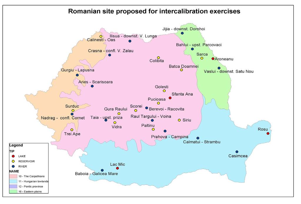
15 Number of Romanian sites proposed for intercalibration exercises 15 for rivers : - 6 for H/G ecological status - 9 for G/M ecological status 17 for lakes : - 4 naturaln lakes : 3 for H/G ecological status 1 for G/M ecological status - 13 reservoirs r : 8 for H/G ecological status 6 for G/M ecological status
16 Ecoregions according to WFD Annex X (Illies( ecoregions for inland waters) 10 ~ The Carpathians: 9 for rivers 2 for lakes 6 for reservoirs 11 ~ Hungarian Lowlands: 2 for reservoirs 12 ~ Pontic Province: 1 for rivers 2 for lakes 3 for reservoirs 16 ~ Eastern Plains: 3 for 3 for rivers 1 for lakes
17
18 Provisionally identification of HMWB, based on hydromorphological changes Physical alterations : Disruptions of the longitudinal river continuity by weirs / barrages ages / sills Disruptions of the lateral river continuity by river engineering connectivity to flood plains (dikes, agricultural works, fish farming f works, etc) River engineering - banks regulation/consolidation Navigation channel Water abstraction, residual water flow, flow deviation Hydropeaking Quantitative criteria for hydro-morphological pressures and impacts assessment, as first stage of the HMWB designation (see table).
19 Physical alterations Effects Parameter considered Pressure significance degree Low Moderate High Disruptions of the Longitudinal river continuity by weirs / barrages / sills Affect the migration of biota 1 and the transport of sediments Sills density (no. / km) or Height of the structure (cm) < 1 < > 3 > 50 Disruptions of the lateral river continuity by river engineering works Affect the riverine vegetation Affect the lateral connectivity and floodplain vegetation Length of dikes / Length of water body (%) Affected surface / Floodplain surface (%) < 30 < > 70 > 70 River engineering - banks regulation / consolidation Affect the river cross section, substrate structure and biota Length of bank / Length of water body (%) < > 70 Navigation channel Affect biota and the river bed Width of navigation channel / Width of river bed (%) < > 70 Water abstraction, residual water flow, flow deviation Hydropeaking Affect biota and bed stability Affect biota Affects biota (low flow) Affects flora and banks Stability Intake or residual flow / Multiannnual mean flow Low flow in river bed / 2 95% + 0,1 (m3/s) Q 95% Low flow in river bed / 2 95% + 0,1 (m3/s) Q 95% Water level gradient (cm) / hour < 10 > 100 >100 < > 50 < 50 < 50 > 100

20 Surface water bodies delineation - Somes-Tisa river basin -
21 TRANSITIONAL AND COASTAL WATERS. ROMANIAN BLACK SEA Transitional waters Marine type Northern Sector from Chilia mouth to Periboina (1 WB); Fluvial type Danube River : Chilia, Sulina and Sf. Gheorghe arms (3 WB); Lacustrine type Sinoe and Mangalia Lakes (2 WB). Coastal waters (Central and Southern Sectors from Periboina to Vama Veche) Sandy shallow type from Periboina to Singol Cape (1 WB); Mixed (sandy and rocky) shallow type from Singol Cape to Vama Veche (2 WB). The coastal waters are defined according to the WFD, respectively y of 1 nautical mile measured from the baseline, within territorial Sea of Romania.

22

23 Only together we can succeed!
Catalonia is a small region, managed by an autonomous government (depending from Spain), and placed in NE. Spain, next to Mediterranean sea.
, and placed in NE. Spain, next to Mediterranean sea.") Characterization of the river basin according to the WFD The Catalan Basins, a case of small Mediterranean water district Planning Department c/ Provença, 204-208 08036-Barcelona Introduction to Catalonia
Characterization of the river basin according to the WFD The Catalan Basins, a case of small Mediterranean water district Planning Department c/ Provença, 204-208 08036-Barcelona Introduction to Catalonia
Management of Sediment Quality and Quantity in the Danube River Basin
 Management of Sediment Quality and Quantity in the Danube River Basin 5 th SedNet Conference 27-29 May 2008 Oslo (N) Igor Liska ICPDR igor.liska@unvienna.org CONTENT ICPDR & EU WFD implementation Sediment
Danube Sediment Management Restoration of Sediment Balance in the Danube A still ongoing project preparation
 Annual Steakholder Seminar Protecting the Environment EU SDR Budapest, 6 November, 2012 Danube Sediment Management Restoration of Sediment Balance in the Danube A still ongoing project preparation Values
Krešimir Žganec, doc. dr. sc. University of Zadar
 Krešimir Žganec, doc. dr. sc. University of Zadar Project aim: highlight the most outstanding freshwater/river ecosystems in Serbia Expected results: A map showing the most outstanding freshwater ecosystems
Human interventions and related impacts in the Danube Delta
 Human interventions and related impacts in the Danube Delta Adrian Stanica, Gheorghe Oaie, Silviu Radan National Institute of Marine Geology and Geoecology GEOECOMAR, Bucharest, Romania Natural evolution
Sediment management in the Danube River Basin. Igor Liška ICPDR
 Sediment management in the Danube River Basin Igor Liška ICPDR Danube River Protection Convention 29 June 1994, Sofia (Bulgaria) Protection of water & ecological resources Sustainable use of water Reduce
Katarina Holubova & Franz Steiner. Joint efforts for cross-border restoration of the Morava river
 Katarina Holubova & Franz Steiner Joint efforts for cross-border restoration BACKGROUND INFORMATION AUSTRIA LOCALITY THE MORAVA RIVER IS THE DANUBE LEFT SIDE TRIBUTARY IN THE LENGTH OF 70 KM FORMS INTERNATIONALLY
Removal of riverbank protection along the River Rhine (the Netherlands)
") RR 2004 3rd European Conference on River Restoration RIVER RESTORATION 2004 Zagreb, Croatia, 17-21 May 2004 Removal of riverbank protection along the River Rhine (the Netherlands) L.J. Bolwidt, H.E.J.
RR 2004 3rd European Conference on River Restoration RIVER RESTORATION 2004 Zagreb, Croatia, 17-21 May 2004 Removal of riverbank protection along the River Rhine (the Netherlands) L.J. Bolwidt, H.E.J.
Fact sheet: Glacial rivers (all Europe)
") Fact sheet: Glacial rivers (all Europe) General description Valleyplanform Hydrology and The valley form varies from a gorge to a V-shaped valley and the single-thread channel is mainly characterized by
Fact sheet: Glacial rivers (all Europe) General description Valleyplanform Hydrology and The valley form varies from a gorge to a V-shaped valley and the single-thread channel is mainly characterized by
Aquaculture Spatial Planning: The case of Greece
 Aquaculture Spatial Planning: The case of Greece Nikos Anagnopoulos Panhellenic Association for Small-Medium sized Aquaculture Enterprises Panhellenic Association for Small-Medium sized Aquaculture Enterprises
European River Catchment Updates: Iceland, Malta and Romania
 Final Draft Working Document European River Catchment Updates: Iceland, Malta and Romania Prepared by: Alejandro IGLESIAS-CAMPOS ETC-LUSI / Junta de Andalucía 11.01.2008 Version 2 Project manager: Ana
Navigable maritime and river waterways in the seaside - Danube Delta area and the connected rural development
 SUMMARY OF Ph-D Thesis, with title RESEARCH STUDIES ON MANAGEMENT IMPROVEMENT OF MARITIME AND RIVER TRANSPORT ACTIVITY IN THE COASTAL AND DANUBE DELTA AREA FROM AN ENVIROMENTAL, ECONOMIC AND SOCIAL PERSPECTIVE
Natura 2000 in the marine environment: state of implementation and next steps
 Life on the blue planet: biodiversity research and the new European marine policies EPBRS European Platform on Biodiversity Research Strategy Porto, Portugal 7-9 November 2007 Natura 2000 in the marine
THE INCIDENCE OF HYDROLOGICAL WARNINGS AT NATIONAL LEVEL INTENSITY AND SPATIAL DISTRIBUTION IN 2009
 THE INCIDENCE OF HYDROLOGICAL WARNINGS AT NATIONAL LEVEL INTENSITY AND SPATIAL DISTRIBUTION IN 2009 R. B TINA 1 ABSTRACT. The incidence of hydrological warnings at national level - Intensity and spatial
Influence of the Major Drainages to the Mississippi River and Implications for System Level Management
 Influence of the Major Drainages to the Mississippi River and Implications for System Level Management Brian M. Vosburg Geologist Louisiana Coastal Protection and Restoration Authority brian.vosburg@la.gov
Strategies for managing sediment in dams. Iwona Conlan Consultant to IKMP, MRCS
 Strategies for managing sediment in dams Iwona Conlan Consultant to IKMP, MRCS 1 Sediment trapping by dams Active storage capacity Dead storage coarse material (bed load) Fine materials (suspension) Francis
Improvement of navigation conditions on the Danube (Calarasi-Braila and Lower Danube) - Ecological concerns?
 - Ecological concerns?") Improvement of navigation conditions on the Danube (Calarasi-Braila and Lower Danube) - Ecological concerns? Georg Rast, Christine Bratrich, Orieta Hulea WWF Germany/DCPO Topics of the presentation Major
Improvement of navigation conditions on the Danube (Calarasi-Braila and Lower Danube) - Ecological concerns? Georg Rast, Christine Bratrich, Orieta Hulea WWF Germany/DCPO Topics of the presentation Major
Report from the SedNet Round Table Discussion November Sediment Management an essential element of River Basin Management Plans
 Report from the SedNet Round Table Discussion 22-23 November 2006 Sediment Management an essential element of River Basin Management Plans Piet den Besten, Steering Group SedNet Objectives WFD River Basin
Annex 29. Sediment Transport with the Danube River Flow and Sedimentation Rates along the Danube- Black Sea Navigation Route
 Annex 29 Sediment Transport with the Danube River Flow and Sedimentation Rates along the Danube- Black Sea Navigation Route The transport of sediments with the Danube River flow is the key factor shaping
BASIS FOR RIVER RESTORATION PROJECT
 The FLUVIO FCT-Doctoral Program Hydromorphological and Habitat Restoration Course Diego García de Jalón and Marta González del Tánago, UPM Madrid BASIS FOR RIVER RESTORATION PROJECT Throughout the course,
A MULTI-CRITERIA APPROACH SUPPORTING THE INVESTIGATION OF A FLOODPLAIN POTENTIALLY CONTAMINATED BY PESTICIDES
 A MULTI-CRITERIA APPROACH SUPPORTING THE INVESTIGATION OF A FLOODPLAIN POTENTIALLY CONTAMINATED BY PESTICIDES L ZILIANI, B GROPPELLI, S CECCON, F COLOMBO (RAMBOLL ENVIRON) D BOCCHIOLA, M C RULLI, G RAVAZZANI,
Turkey National Report
 UNITED NATIONS Working Paper GROUP OF EXPERTS ON No. 26 GEOGRAPHICAL NAMES Twenty-third Session Vienna, 28 March 4 April 2006 Item 5 of the Provisional Agenda: Reports of the division Turkey National Report
Impact of the Danube River on the groundwater dynamics in the Kozloduy Lowland
 GEOLOGICA BALCANICA, 46 (2), Sofia, Nov. 2017, pp. 33 39. Impact of the Danube River on the groundwater dynamics in the Kozloduy Lowland Peter Gerginov Geological Institute, Bulgarian Academy of Sciences,
Extreme Phenomena in Dobrogea - Floods and Droughts
 Extreme Phenomena in Dobrogea - Floods and Droughts PhD eng. Carmen Maftei Ovidius University of Constanta (Partner no 4) OUTLINES Introduction Study area Drought Floods Conclusion What is the problem?
Mapping of marine habitats in shallow coastal areas in Denmark
 6 th Workshop Seabed Acoustics, Rostock, November 14/15, 2013 P11-1 Mapping of marine habitats in shallow coastal areas in Denmark Dr. Zyad Al-Hamdani Geological Survey of Denmark and Greenland - GEUS
Wetland & Floodplain Functional Assessments and Mapping To Protect and Restore Riverine Systems in Vermont. Mike Kline and Laura Lapierre Vermont DEC
 Wetland & Floodplain Functional Assessments and Mapping To Protect and Restore Riverine Systems in Vermont Mike Kline and Laura Lapierre Vermont DEC NWI+ Hydro-Geomorphic Characterization of Wetlands and
SusWater WP6 Status desember 2017
 SusWater WP6 Status desember 2017 Mesohabitater / strømningstyper Elvetyper Workshops Leveranser WP6 Forsker-workshops Nordisk vannforvaltning EU WFD Ad-hoc task force HyMo Notater og rapporter Test av
Country Fiche Latvia Updated October 2016
 Country Fiche Latvia Updated October 2016 1. General information Marine area under Latvian jurisdiction includes inland sea waters, Territorial sea (12 nautical miles from the baseline) and exclusive economic
BURGAS CASE STUDY: LAND-SEA INTERACTIONS
 BURGAS CASE STUDY: LAND-SEA INTERACTIONS Dr. Margarita Stancheva IO-BAS, Bulgaria Name of presentation CROSS BORDER MARITIME SPATIAL PLANNING IN THE BLACK SEA ROMANIA AND BULGARIA (MARSPLAN BS) Project
HELSINKI COMMISSION Baltic Marine Environment Protection Commission
 HELSINKI COMMISSION Baltic Marine Environment Protection Commission HELCOM RECOMMENDATION 24/10 Adopted 25 June 2003, having regard to Article 20, Paragraph 1 b) of the 1992 Helsinki Convention IMPLEMENTATION
Country Fiche Latvia.
 Country Fiche Latvia 1. General information Marine waters under Latvian jurisdiction include inland sea waters, territorial sea (12 nautical miles from the baseline) and exclusive economic zone (EEZ) waters.
Ecoregions Glossary. 7.8B: Changes To Texas Land Earth and Space
 Ecoregions Glossary Ecoregions The term ecoregions was developed by combining the terms ecology and region. Ecology is the study of the interrelationship of organisms and their environments. The term,
APPROACH TO THE SPANISH WATER ORGANISATION IMPROVING FLOOD HAZARD MAPPING, LAWS AND AUTHORITIES COORDINATION
 "Workshop On Land Use Planning And Water Management, With Focus On Flood Risk Management Oslo, Norway. Wednesday 31 January and Thursday 1 February 2007 APPROACH TO THE SPANISH WATER ORGANISATION IMPROVING
Stream Restoration and Environmental River Mechanics. Objectives. Pierre Y. Julien. 1. Peligre Dam in Haiti (deforestation)
") Stream Restoration and Environmental River Mechanics Pierre Y. Julien Malaysia 2004 Objectives Brief overview of environmental river mechanics and stream restoration: 1. Typical problems in environmental
Stream Restoration and Environmental River Mechanics Pierre Y. Julien Malaysia 2004 Objectives Brief overview of environmental river mechanics and stream restoration: 1. Typical problems in environmental
Pilot-Project Project Bad Deutsch Altenburg:
 Pilot-Project Project Bad Deutsch Altenburg: River Restoration and Prevention of Riverbed-Erosion in the Danube Floodplain National Park (Austria) Stefan Schneeweihs Mohács, 2013 11 18 Pictures: F. Kovacs,
Environmental impact assessment study of the new offshore dumping sites for Šventoji port in Lithuania
 Environmental impact assessment study of the new offshore dumping sites for Šventoji port in Lithuania Introduction Summary In 2003 Lithuanian Ministry of Transport initiated the preparation of feasibility
The global and local anthropogenic impacts on Danube Delta in the sustainable development perspective. Roxana Bojariu. Outline
 The global and local anthropogenic impacts on Danube Delta in the sustainable development perspective Roxana Bojariu Outline Danube Delta history and present state Climate dynamics and change Observed
The River Continuum Concept (or not?) Stream Classification
 Stream Classification") The River Continuum Concept (or not?) Stream Classification Goal: Generalization 2 general types of classification streams (longitudinal) streams (e.g., hydrologic regime classification) Longitudinal Classification
The River Continuum Concept (or not?) Stream Classification Goal: Generalization 2 general types of classification streams (longitudinal) streams (e.g., hydrologic regime classification) Longitudinal Classification
Licca Liber - the free Lech
 Licca Liber - the free Lech Source: W. Schilling WWA Donauwörth The river Lech an overview Hydrography / Hydrology catchment area 4000 km² Length 256 km Delta H 1100 m Slope Ø 0,4 % discharge in Augsburg
DEVELOPING AN ECOLOGICAL AND MIGRATION SYSTEM FOR ICHTHYOFAUNA ON THE CRIŞUL REPEDE RIVER NEAR THE CITY HALL OF ORADEA
 Management of Sustainable Development Sibiu, Romania, Volume 5, No.2, December 2013 DOI 10.2478/msd-2013-0012 DEVELOPING AN ECOLOGICAL AND MIGRATION SYSTEM FOR ICHTHYOFAUNA ON THE CRIŞUL REPEDE RIVER NEAR
Management Planning & Implementation of Communication Measures for Terrestrial Natura 2000 Sites in the Maltese Islands Epsilon-Adi Consortium
 Management Planning & Implementation of Communication Measures for Terrestrial Natura 2000 Sites in the Maltese Islands Epsilon-Adi Consortium Briefing Meetings, February 2013 CT3101/2011, MEPA, Malta
THE INFLUENCE OF THE HYDRO-METEOROLOGICAL PHENOMENA AND THE STORM EFFECTS ON THE SHORE OF THE SOUTHERN GEOMORPHOLOGIC UNIT OF THE ROMANIAN COASTLINE
 RISCURI I CATASTROFE, NR. XI, VOL. 11, NR. 2/2012 THE INFLUENCE OF THE HYDRO-METEOROLOGICAL PHENOMENA AND THE STORM EFFECTS ON THE SHORE OF THE SOUTHERN GEOMORPHOLOGIC UNIT OF THE ROMANIAN COASTLINE M.
Birch Creek Geomorphic Assessment and Action Plan
 Birch Creek Geomorphic Assessment and Action Plan Jim Webster Tim Hanrahan, PhD, CFM Jesse Schwartz, PhD Zach Hill January 22, 2015 White Eagle Grange This Project is a First Step in Strategy Planning
WORKSHOP #2 [Modeling and Sediment Transfers Review of alternative solutions] Bucharest 07 October 2015
![WORKSHOP #2 [Modeling and Sediment Transfers Review of alternative solutions] Bucharest 07 October 2015](/thumbs/82/85703998.jpg "WORKSHOP #2 [Modeling and Sediment Transfers Review of alternative solutions] Bucharest 07 October 2015") STUDIU DE FEZABILITATE PENTRU SOLUŢII TEHNICE ALTERNATIVE/COMPLEMENTARE PRIVIND LUCRĂRILE CE SE VOR EXECUTA ÎN PUNCTUL CRITIC 01 BALA DIN CADRUL PROIECTULUI ÎMBUNĂTĂŢIREA CONDIŢIILOR DE NAVIGAŢIE PE DUNĂRE
STUDIU DE FEZABILITATE PENTRU SOLUŢII TEHNICE ALTERNATIVE/COMPLEMENTARE PRIVIND LUCRĂRILE CE SE VOR EXECUTA ÎN PUNCTUL CRITIC 01 BALA DIN CADRUL PROIECTULUI ÎMBUNĂTĂŢIREA CONDIŢIILOR DE NAVIGAŢIE PE DUNĂRE
Sediment management: a european perspective. Piet den Besten Centre for Water Management Rijkswaterstaat, Netherlands
 Sediment management: a european perspective Piet den Besten Centre for Water Management Rijkswaterstaat, Netherlands Content Background of Dutch-German exchange (DGE plus) What is needed for adequate sediment
The textural character of the littoral sediments between Sfântu Gheorghe and Gura Portiţa
 The textural character of the littoral sediments between Sfântu Gheorghe and Gura Portiţa Gicu OPREANU National Institute of Marine Geology and Geo-ecology (GeoEcoMar), Romania, 23-25, Dimitrie Onciul
BURGAS CASE STUDY: LAND-SEA INTERACTIONS. Dr. Margarita Stancheva
 BURGAS CASE STUDY: LAND-SEA INTERACTIONS Dr. Margarita Stancheva Name of presentation NEED FOR COHERENCE BETWEEN LAND AND SEA ACTIVITIES Name presenter Burgas is the fourth largest city in Bulgaria and
Restoring river-floodplain interconnection and riparian habitats along the embanked Danube between Neuburg and Ingolstadt (Germany)
") Restoring river-floodplain interconnection and riparian habitats along the embanked Danube between Neuburg and Ingolstadt (Germany) Dipl.-Geogr. Gerald Blasch Department of Physical Geography, Cath. University
Restoring river-floodplain interconnection and riparian habitats along the embanked Danube between Neuburg and Ingolstadt (Germany) Dipl.-Geogr. Gerald Blasch Department of Physical Geography, Cath. University
Metadata Drava & Mura River Basins (Austria)
") Metadata Drava & Mura River Basins (Austria) Exported from the Freshwater Biodiversity Data Portal, http://data.freshwaterbiodiversity.eu Visit the Freshwater Metadatabase, http://data.freshwaterbiodiversity.eu/metadb/about_metadata
Metadata Drava & Mura River Basins (Austria) Exported from the Freshwater Biodiversity Data Portal, http://data.freshwaterbiodiversity.eu Visit the Freshwater Metadatabase, http://data.freshwaterbiodiversity.eu/metadb/about_metadata
Subcommittee on Sedimentation Draft Sediment Analysis Guidelines for Dam Removal
 Subcommittee on Sedimentation Draft Sediment Analysis Guidelines for Dam Removal August 4, 2011 Jennifer Bountry, M.S., P.E. Tim Randle, M.S., P.E., D.WRE. Blair Greimann, Ph.D., P.E. Sedimentation and
SPLAN-Natura Towards an integrated spatial planning approach for Natura th January, 2017 Brussels. Commissioned by DG Environment
 SPLAN-Natura 2000 Towards an integrated spatial planning approach for Natura 2000 Commissioned by DG Environment 17 th January, 2017 Brussels V. Simeonova (Ph.D.) Drivers towards integrating Biodiversity
24.0 Mineral Extraction
 Chapter 24 - Mineral Extraction 24.0 Mineral Extraction 24.1 Introduction Apart from gravel, sand, rock, limestone and salt extraction in relatively small quantities mineral extraction is not a strong
A new fauna intercalibration typology
 A new fauna intercalibration typology WFD Intercalibration - 2nd phase - Baltic GIG Auftraggeber: Landesamt für Natur und Umwelt Schleswig-Holstein Hamburger Chaussee 25 24220 Flintbe Author: Torsten Berg
Mediteranean sea issues in the view of ESPON ESaTDOR project and Marine Spatial Planning in Slovenia
 DIREKTORAT ZA PROSTOR, GRADITEV IN STANOVANJA Mediteranean sea issues in the view of ESPON ESaTDOR project and Marine Spatial Planning in Slovenia BlueMed meeting of stakeholders on a micro-regional level
Integrated methodology for assessing the effects of geomorphological river restoration on fish habitat and riparian vegetation
 Integrated methodology for assessing the effects of geomorphological river restoration on fish habitat and riparian vegetation Judit Maroto *a, Miguel Marchamalo a,b, Diego García de Jalón a, Marta González
STATUS QUO REPORT ON ENC ACTIVITIES
 NETWORK OF DANUBE WATERWAY ADMINISTRATIONS South-East European Transnational Cooperation Programme STATUS QUO REPORT ON ENC ACTIVITIES UA - SHS Document ID: Activity: 5.2 Author / Project Partner: Date:
Country Fiche Lithuania
 Country Fiche Lithuania Updated June 2018 1. General information The Lithuanian maritime space is delimited by the Decree of the Government of the Republic of Lithuania of 6 December, 2004, No. 1597 and
Suspended sediment yields of rivers in Turkey
 Erosion and Sediment Yield: Global and Regional Perspectives (Proceedings of the Exeter Symposium, July 1996). IAHS Publ. no. 236, 1996. 65 Suspended sediment yields of rivers in Turkey FAZLI OZTURK Department
Depositional Environments. Depositional Environments
 Depositional Environments Geographic area in which sediment is deposited Characterized by a combination of geological process & environmental conditions Depositional Environments Geological processes:
NATURAL RIVER. Karima Attia Nile Research Institute
 NATURAL RIVER CHARACTERISTICS Karima Attia Nile Research Institute NATURAL RIVER DEFINITION NATURAL RIVER DEFINITION Is natural stream of water that flows in channels with ih more or less defined banks.
Scheepvaart en ecologische doelstellingen
 Scheepvaart en ecologische doelstellingen Margriet Schoor 25 April 2008 The Rhine Delta Rotterdam 2/3 1/3 Scheepvaart en ecologische doelstellingen 2 Germany Navigation on the Rhine Busiest river in Europe
The River Restoration Centre therrc.co.uk. Understanding Fluvial Processes: supporting River Restoration. Dr Jenny Mant
 The River Restoration Centre therrc.co.uk Understanding Fluvial Processes: supporting River Restoration Dr Jenny Mant Jenny@therrc.co.uk Understanding your catchment Hydrology Energy associated with the
Riparian Assessment. Steps in the right direction... Drainage Basin/Watershed: Start by Thinking Big. Riparian Assessment vs.
 Riparian Assessment vs. Monitoring Riparian Assessment What is a healthy stream? Determine stream/riparian health Determine change or trend, especially in response to mgmt Classification = designation
AN EXCESSIVELY FROSTY MONTH - JANUARY 1963
 AN EXCESSIVELY FROSTY MONTH - JANUARY 1963 ELENA NICULESCU 1 Key-words: January 1963, negative thermal imblances, Romania Against the continental-temperate climatic background of Romania, the presence
Natural Shoreline Landscapes on Michigan Inland Lakes
 Natural Shoreline Landscapes on Michigan Inland Lakes Excerpts from Chapters 2 and 3 Photo Photo by Jane by Jane Herbert Herbert Did you know? Twenty-four species of amphibians, 25 species of reptiles,
Strengthening the cooperation in the region: Carpathian, Tisa,, Danube and Black Sea areas
 Strengthening the cooperation in the region: Carpathian, Tisa,, Danube and Black Sea areas 14th October 2009 SEE Annual Conference Advancing development through transnational cooperation in South East
Landslide Hazard Assessment Methodologies in Romania
 A Scientific Network for Earthquake, Landslide and Flood Hazard Prevention SciNet NatHazPrev Landslide Hazard Assessment Methodologies in Romania In the literature the terms of susceptibility and landslide
European Landscape Convention in the Slovak Republic
 13th COUNCIL OF EUROPE MEETING OF THE WORKSHOPS FOR THE EUROPEAN LANDSCAPE CONVENTION European Landscape Convention in the Slovak Republic Mrs. Ida Vanáková, state advisor, Department of Spatial Planning
Newsletter # 2. Pilot sites in Greece. December 2018
 A HarmonizEd framework to Mitigate coastal EroSion promoting ICZM protocol implementation Newsletter # 2 December 2018 View of a beach in Ammolofi ( Paggaio Municipality ) Pilot sites in Greece 1. Name
Fluvial Systems Lab Environmental Geology Lab Dr. Johnson
 Fluvial Systems Lab Environmental Geology Lab Dr. Johnson *Introductory sections of this lab were adapted from Pidwirny, M. (2006). "Streamflow and Fluvial Processes". Fundamentals of Physical Geography,
SCOPE OF PRESENTATION STREAM DYNAMICS, CHANNEL RESTORATION PLANS, & SEDIMENT TRANSPORT ANALYSES IN RELATION TO RESTORATION PLANS
 DESIGN METHODS B: SEDIMENT TRANSPORT PROCESSES FOR STREAM RESTORATION DESIGN PETER KLINGEMAN OREGON STATE UNIVERSITY CIVIL ENGINEERING DEPT., CORVALLIS 2 ND ANNUAL NORTHWEST STREAM RESTORATION DESIGN SYMPOSIUM
Consequences of river regulation works: altered fluvial processes + increasing flood hazard
 Consequences of river regulation works: altered fluvial processes + increasing flood hazard Dr. Tímea Kiss assistant professor Department of Physical Geography and Geoinformatics, University of Szeged,
Background to the PFRA European Overview - UC9810.5b
 Background to the PFRA European Overview - UC9810.5b The individual Member State Reports reflect the situation as reported by the Member States to the European Commission in 2012 The situation in the MSs
Coastal and Marine Ecological Classification Standard (CMECS)
") Coastal and Marine Ecological Classification Standard (CMECS) Mark Finkbeiner NOAA Coastal Services Center Presented at the International Workshop on Seabed Mapping Methods and Technology 18 October 2012
Coastal and Marine Ecological Classification Standard (CMECS) Mark Finkbeiner NOAA Coastal Services Center Presented at the International Workshop on Seabed Mapping Methods and Technology 18 October 2012
The Imperative of Sediment Management Concepts in River Basin Management Plans
 The Imperative of Sediment Management Concepts in River Basin Management Plans Stefan Vollmer, Thomas Hoffmann, Gudrun Hillebrand, Ina Quick, Axel Winterscheid Department M3 Groundwater, Geology, River
Floodplain modeling. Ovidius University of Constanta (P4) Romania & Technological Educational Institute of Serres, Greece
 Romania & Technological Educational Institute of Serres, Greece") Floodplain modeling Ovidius University of Constanta (P4) Romania & Technological Educational Institute of Serres, Greece Scientific Staff: Dr Carmen Maftei, Professor, Civil Engineering Dept. Dr Konstantinos
Floodplain modeling Ovidius University of Constanta (P4) Romania & Technological Educational Institute of Serres, Greece Scientific Staff: Dr Carmen Maftei, Professor, Civil Engineering Dept. Dr Konstantinos
Marine/Maritime Spatial Planning Andrej Abramić
 Marine/Maritime Spatial Planning Andrej Abramić EcoAqua SUMMER SCHOOL: Ecosystem approach to aquaculture 26-29th of October 2015 Research and Technology to enhance excellence in Aquaculture development
Lab 7: Sedimentary Structures
 Name: Lab 7: Sedimentary Structures Sedimentary rocks account for a negligibly small fraction of Earth s mass, yet they are commonly encountered because the processes that form them are ubiquitous in the
Description DESCRIPTION
 DESCRIPTION The location of the Upper James Watershed is located in northeastern South Dakota as well as southeastern North Dakota. It includes the following counties located in North Dakota Barnes, Dickey,
Habitats habitat concept, identification, methodology for habitat mapping, organization of mapping
 Habitats habitat concept, identification, methodology for habitat mapping, organization of mapping Rastislav Lasák & Ján Šeffer Training Implementation of Habitats Directive - Habitats and Plants 1 What
Flood mapping in the Danube RBD. Igor Liska ICPDR Secretariat
 Flood mapping in the Danube RBD Igor Liska ICPDR Secretariat EFD Art 6 Member States shall, at the level of the river basin district, or unit of management referred to in EFD Article 3(2)(b), prepare flood
CHANGES IN THE STRUCTURE OF POPULATION AND HOUSING FUND BETWEEN TWO CENSUSES 1 - South Muntenia Development Region
 TERITORIAL STATISTICS CHANGES IN THE STRUCTURE OF POPULATION AND HOUSING FUND BETWEEN TWO CENSUSES 1 - South Muntenia Development Region PhD Senior Lecturer Nicu MARCU In the last decade, a series of structural
Country reports. Israel did not establish an Exclusive Economic Zone. Consequently, its jurisdiction is restricted to the Israeli territorial waters.
 Country reports I. ISRAEL Disclaimer This document has not been adopted by the European Commission and should therefore not be relied upon as a statement of the European Commission. The purpose of this
2012 FORUM OF MARINE PROTECTED AREAS IN THE MEDITERRANEAN ANTALYA, TURKEY
 2012 FORUM OF MARINE PROTECTED AREAS IN THE MEDITERRANEAN ANTALYA, TURKEY SPECIAL EVENT Challenges for Open Seas MPAs in the Mediterranean region November 27, 2012. 15h00-16H00 Slide # 1 2012 FORUM OF
Copernicus for Coastal Zone Monitoring and Management
 Copernicus for Coastal Zone Monitoring and Management DG-Grow, 29 June 2017 User Requirement Perspective: Monitoring of coastal zones, pressures and impacts on nature and people Courtesy: J. Ekebom storm
Dam Removal Analysis Guidelines for Sediment
 A review of: Dam Removal Analysis Guidelines for Sediment Joe Rathbun (Retired) rathbunj@sbcglobal.net Some Potential Sediment Issues Reservoir restoration Downstream water quality Downstream deposition
Kootenai River Habitat Restoration Program Update
 Kootenai River Habitat Restoration Program Update Kootenai Tribe of Idaho Kootenai Valley Resource Initiative November 19, 2012 Bonners Ferry, Idaho Changes to Kootenai Basin Beaver trapping Floodplain
River Restoration and Rehabilitation. Pierre Y. Julien
 River Restoration and Rehabilitation Pierre Y. Julien Department of Civil and Environmental Engineering Colorado State University Fort Collins, Colorado River Mechanics and Sediment Transport Lima Peru
2SEA. Requirements Report SOILS2SEA DELIVERABLE NO. 1.2
 SOILS2SEA DELIVERABLE NO. 1.2 Requirements Report 2SEA Reducing nutrient loadings from agricultural soils to the Baltic Sea via groundwater and streams 3.5 Baltic Sea Basin 3.5.1 Description The Baltic
RANGE AND ANIMAL SCIENCES AND RESOURCES MANAGEMENT - Vol. II - Catchment Management A Framework for Managing Rangelands - Hugh Milner
 CATCHMENT MANAGEMENT A FRAMEWORK FOR MANAGING RANGELANDS Hugh Milner International Water Management Consultant, Australia Keywords: Rangeland management; catchments and watersheds; catchment management
MARSPLAN-BS NEWSLETTER
 MARSPLAN-BS NEWSLETTER MARSPLAN-BS Consortium March 2017 In this issue: Cross Border Maritime Spatial Planning in the Black Sea Romania and Bulgaria (MARSPLAN-BS) Echoes from recent events 8 th Thematic
DANUBEparksCONNECTED WP 3 WILDisland
 DANUBEparksCONNECTED WP 3 WILDisland Towards a Danube Wild Island Habitat Corridor WP responsible partner: Duna Ipoly National Park Total Budget: 680.959,20 Act. 3.1: Danube WILDisland learning process
Baltic Sea Region cooperation in Maritime Spatial Planning - HELCOM/VASAB
 Baltic Sea Region cooperation in Maritime Spatial Planning - HELCOM/VASAB Sten Jerdenius Swedish Ministry of the Environment HELCOM/VASAB MSP Group Baltic Sea Region subregional workshop Espoo 31 March
Sediment project proposal. EUSDR PA4 SG meeting June 9 th Dr. László KARDOSS
 Sediment project proposal EUSDR PA4 SG meeting June 9 th 2015. Dr. László KARDOSS Content Overview of the events Quick glance at the project content Steps to be made Acknowledgements Since the last PA4
MEMORANDUM FOR SWG
 MEMORANDUM FOR SWG-2007-1623 Subject: Jurisdictional Determination (JD) for SWG-2007-1623 on Interdunal Wetlands Adjacent to Traditional Navigable Waters (TNWs) Summary The U.S. Environmental Protection
Use of benthic invertebrate biological indicators in evaluating sediment deposition impairment on the Middle Truckee River, California
 Use of benthic invertebrate biological indicators in evaluating sediment deposition impairment on the Middle Truckee River, California David B. Herbst Sierra Nevada Aquatic Research Laboratory University
2008 SIVECO Romania. All Rights Reserved. Geography. AeL econtent Catalogue
 2008 SIVECO Romania. All Rights Reserved. Geography AeL econtent Catalogue The Earth's Movements Recommended for two hours of teaching. AeL Code: 352. 2. The Earth Rotation Movement in 24 hours 3. The
The SedAlp Project: WP6: INTERACTION WITH STRUCTURES
 The SedAlp Project: WP6: INTERACTION WITH STRUCTURES 6 th International conference Water in the Alps Herrenchiemsee, 12 th of October, 2016 Jošt Sodnik Contents Structure of SedAlp project (www.sedalp.eu)
Drought News August 2014
 European Drought Observatory (EDO) Drought News August 2014 (Based on data until the end of July) http://edo.jrc.ec.europa.eu August 2014 EDO (http://edo.jrc.ec.europa.eu) Page 2 of 8 EDO Drought News
Diagnostic Geomorphic Methods for Understanding Future Behavior of Lake Superior Streams What Have We Learned in Two Decades?
 Diagnostic Geomorphic Methods for Understanding Future Behavior of Lake Superior Streams What Have We Learned in Two Decades? Faith Fitzpatrick USGS WI Water Science Center, Middleton, WI fafitzpa@usgs.gov