MAPPING THE FLASH FLOOD PRONE AREA IN THE TAITA WATERSHED (ROMANIA) USING TOPOGRAPHIC INDEXES AND HYDRAULIC MODEL
|
|
|
- Cecilia Dennis
- 5 years ago
- Views:
Transcription


1 ICNAR 2014 MAPPING THE FLASH FLOOD PRONE AREA IN THE TAITA WATERSHED (ROMANIA) USING TOPOGRAPHIC INDEXES AND HYDRAULIC MODEL C. Maftei K. Papatheodorou
2 Outline Research context Research objective Research approach Results and discussion 2
3 Research context Climate change impact Flood Effects of flood temperature ( ) >1.3 o C (pre-industrial period) spatial and temporal variability of precipitation frequency of extreme precipitation intensity and frequency of river floods in winter and spring (in various regions) N o events ( ) N o events in Europe 325 (200 since 2000) No of people killed: Av. people killed per year:6,753 Economic Damage (bill. US$): 397,333,885 Application of Flood Directive Prepare flood hazard and risk maps Prepare flood risk management plans scenario considered: frequent event (low probability) medium event (medium probability years) extreme event (high probability years). Flood elements provided flood extent, WS profile, WS depth, WS velocity 3

4 Research objectives Re-examine the flood mapping methodology Propose a method to assess the spatial extent of flooding USGS 1988 NFIP and FEMA APFM Morphologic and Hydraulic coupled models 4
5 Research approach Flood problem in the Dobrogea region Status and analysis of observations Mapping the flood prone area Evaluate results 5

6 Flood mapping methodology Flood mapping production according USGS-1988 comprehensive intermediate approximate 1.detailed 2. historical 3.analytical 4.physiographic 5.reconnaissance statistical analysis Flood mapping production according with FEMA regional method Empirical model RR model Watershed model determining T-year discharge general examination of the stream to approximate the area that would be inundated hydraulic model no gauged basin? yes flood map delineation regression equation, index-flood relation, area-altitude relation, rational model, unit hydrograph simulation model flood frequency analysis no 3 4 determining T-year water-surface profile or depth? yes Chezy and the Manning formula The T-year profile is obtained by adding T-year depths to the channelbed profile 2 which method are using? 1 develop a profile for the historical flood on the basis of high-water marks determine the frequency of the historical flood define ratios of observed flood depths to depths for discharges of various recurrence intervals determine the adjustment needed to convert from the historical profile to the T-year profile flood routing dynamic equation of gradually varied flow 6 developing a flood-boundary map transferring altitudes from a water-surface profile to a map

7 Dobrogea region Location Geo-morphology Climate Temperature Precipitation Hydrology 7

8 Flood problem in the Dobrogea region No Town, village Date Characteristics Damages 1. Garlița 1963; Casian mc/s* 3. Lumina household teared down and animals taken away by the floods Households and crops destroyed, human lives lost Flooded households and destroyed 4. Runcu h apa=1.60 m Households destroyed and 5 deaths 5. Baia Households and gardens flooded 6. Constanța Households flooded in ;28 rainfall >200 mm/12 h the Western area, 3, deaths Households and 7. Nuntaşi/Nuntasi mc/s (fig. ) gardens flooded, 1 death 8. Cheia 9. Costineşti Casimcea/Casimce a Cheia/Casimcea Cuza Voda/Agi Cabul Negureni, Valea Marea V VIII Flood coming from upstream, at Biruinta registeredt>300mm/2 4 h 398mc/s* 384mc/s* 2-4 IX ,8 * 2-7 IX ,8 * 13 Albesti V mc/s* Sacele, raul Valea Sacele Saraiu, raul Topolog Biruinta,/ Valea Biruinta 8-9 VIII mc/s* 2-20 VII mc/s* IX mc/s* 17 Urluia/V.Urluia VI mc/s* Households and gardens flooded, school Damages to the railway, access roads, restaurants, households in Schitu Households and gardens flooded, access bridge damaged no no 8 18 Taita/Taita mc/s


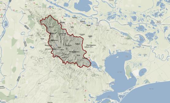
9 Study area and Taita catchment area 591 km 2 elevation ranges 261m 10 tributaries part of North Dobrogea Plateau the main source of supply precipitation 74% The hydrometric data are collected in two hydrometric stations: Hamcearca Satu Nou Vegetation >33% forest 9
10 data base In this study the series of annual maximum stream flow, covering the period 1968 (1965) have been used. 10


11 Mapping the flood prone area Flooding mapping proposed yes gauged basins? no Observed data Topographic Land use Historical flood event flood frequency determining T-years discharge Hydraulic model river profiles cross section roughness coeff. DEM Geomorphological model Roughnes map Historical map Flood parameters WS profile WS depth Flood map hazard Calibrate 11
12 Flood frequency: frequent event (low probability -10 years) 50 years medium event (medium probability years) extreme event (high probability years). Pearson III distribution 30mc/s 56mc/s 74mc/s 192mc/s Hydraulic model ArcGIS Topographic Map Contour Map DEM Hydrology HEC GEORAS Set of RAS geometry: river system banks cross section RAS RUN HEC RAS Set of HEC RAS results: water surface level velocity discharge in cross section Geomorphological model Topographic Wetness Index (TWI) SAGA Wetness Index (SWI) Calculation Models Set of maps: Flow direction Flow accumulation BH Delineation Generate GIS export file Result prepocessing Ras Mapping Generate GIS export file Delineation Flood plain 12

. Sørensen R., U.")
. Boehner, J., Koethe, R. Conrad, O., Gross, J., Ringeler, A., Selige, T.")
13 Geomorphological Model Topographic Wetness Index (TWI) & SAGA Wetness Index (SWI) Calculation Model TWI As: Accumulation per unit contour length β: slope Software Used Beven, K. and Kirkby, M. : A physical variable contributing area model of catchment hydology, Hydrolog. Sci. Bull., 24(1), 43 69, (1979). Moore, I. D., Burch, G. J., and Mackenzie, D. H.: 'Topographic effects on the distribution of surface soil water and the location of ephemeral gullies', Trans. Am. Soc. Agr. Engrs., 31, , (1988). Sørensen R., U. Zinko, and J. Seibert: On the calculation of the topographic wetness index: evaluation of different methods based on field observations. Hydrol. Earth Sys. Sci. Discuss., 2, , European Geosciences Union, (2005). Boehner, J., Koethe, R. Conrad, O., Gross, J., Ringeler, A., Selige, T.: Soil Regionalisation by Means of Terrain Analysis and Process Parameterisation. In: Micheli, E., Nachtergaele, F., Montanarella, L. [Ed.]: Soil Classification European Soil Bureau, Research Report No. 7, EUR EN, Luxembourg. pp , (2002) 13

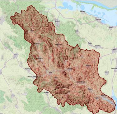
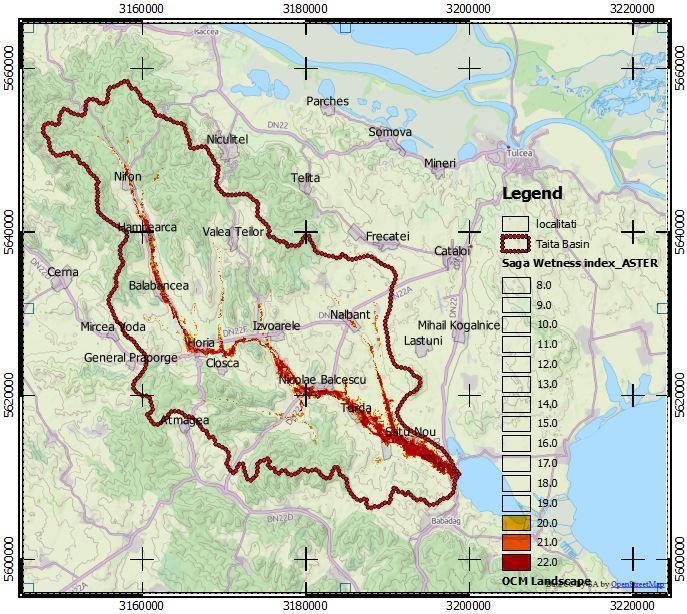


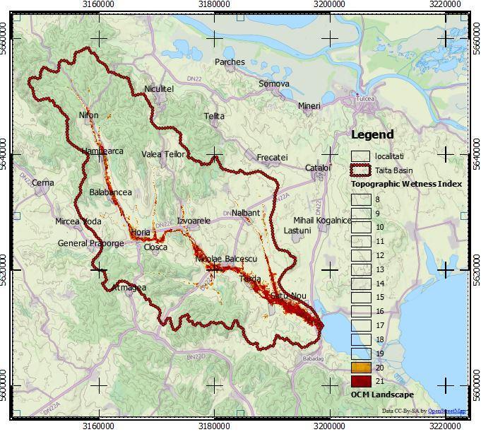
14 Geomorphological Model - Results SAGA T.W.I. Software Used Geodetic Reference System: Dealul Piscului 1970/ Stereo 70 Terrain Ruggedness Index Stream Power Index 14 Geodetic Reference System: Dealul Piscului 1970/ Stereo 70 Topographic Wetness Index (TWI)

15 Results hydraulic model years return period 1000 years return period

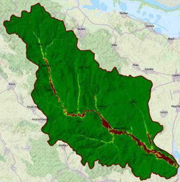
16 Comparison of Results 16 Geodetic Reference System: Dealul Piscului 1970/ Stereo 70
17 Conclusions (1/3) Hydrologic and hydraulic modeling was applied to assess flash flood prone areas delineation and flood hazard, by using widely accepted FFH assessment methodologies. Flash flood prone areas were delineated using the Topographic Wetness Index (based on TOPMODEL) and the SAGA WI geomorphological models. Inundation areas were also delineated using the HEC- RAS hydraulic model by taking into consideration 100 and 1000 years return periods. 17
18 Conclusions (2/3) Comparison of the results of the different type models used, shows that there is a remarkable convergence in the delineation of the inundation (flooded) area despite the fact that these models have very different input data requirements. Taking into consideration that the geomorfological models have minimal data requirements as the required data are readily available (ASTER DEMs, topographical data), these models can be used to reliably delineate flood prone areas on a regional scale in order to proceed with Risk assessment. At a next stage, hydraulic models can be used especially on site-specific (local) scales in order to accurately estimate the flooding parameters (inunndation area, depth, flood water velocity etc), thus helping make decisions about designing effective preventive measures. 18
19 Conclusions (3/3) To demonstrate the broad applicability of the selected methodologies, open source software was used to store, process data and create maps. As resulted, Quantum GIS (v.2.1), SAGA GIS (v.2.08) and HEC-RAS can be effectively used to fully apply the proposed methodological approach as they provide very reliable platforms at no cost. Acknowledgments: The research was partially funded by the EU within the context of the Black Sea Basin Joint Operational Programme
Floodplain modeling. Ovidius University of Constanta (P4) Romania & Technological Educational Institute of Serres, Greece
 Romania & Technological Educational Institute of Serres, Greece") Floodplain modeling Ovidius University of Constanta (P4) Romania & Technological Educational Institute of Serres, Greece Scientific Staff: Dr Carmen Maftei, Professor, Civil Engineering Dept. Dr Konstantinos
Floodplain modeling Ovidius University of Constanta (P4) Romania & Technological Educational Institute of Serres, Greece Scientific Staff: Dr Carmen Maftei, Professor, Civil Engineering Dept. Dr Konstantinos
Extreme Phenomena in Dobrogea - Floods and Droughts
 Extreme Phenomena in Dobrogea - Floods and Droughts PhD eng. Carmen Maftei Ovidius University of Constanta (Partner no 4) OUTLINES Introduction Study area Drought Floods Conclusion What is the problem?
ASFPM - Rapid Floodplain Mapping
 ASFPM - Nicole Cominoli Hydraulic Engineer USACE - Omaha District mary.n.cominoli@usace.army.mil June 3, 2015 US Army Corps of Engineers Mitigation = Risk Informed Decisions 2 The National Flood Insurance
Using Morphometric models and Open Source Software to locate Flood prone areas A guide to pilot Implementation
 SciNetNatHaz Project Progress Meeting - 23-26 Oct 2014, Burgas, Bulgaria SciNetNatHaz Project Progress Meeting - 7-9 May 2015, Thessaloniki, Hellas Using Morphometric models and Open Source Software to
Use of Geospatial data for disaster managements
 Use of Geospatial data for disaster managements Source: http://alertsystemsgroup.com Instructor : Professor Dr. Yuji Murayama Teaching Assistant : Manjula Ranagalage What is GIS? A powerful set of tools
Floodplain Modeling and Mapping Using The Geographical Information Systems (GIS) and Hec-RAS/Hec-GeoRAS Applications. Case of Edirne, Turkey.
 and Hec-RAS/Hec-GeoRAS Applications. Case of Edirne, Turkey.") Floodplain Modeling and Mapping Using The Geographical Information Systems (GIS) and Hec-RAS/Hec-GeoRAS Applications. Case of Edirne, Turkey. Fuad Hajibayov *1, Basak Demires Ozkul 1, Fatih Terzi 1 1 Istanbul
Floodplain Modeling and Mapping Using The Geographical Information Systems (GIS) and Hec-RAS/Hec-GeoRAS Applications. Case of Edirne, Turkey. Fuad Hajibayov *1, Basak Demires Ozkul 1, Fatih Terzi 1 1 Istanbul
Hydrologic and Hydraulic Analyses Using ArcGIS
 Hydrologic and Hydraulic Analyses Using ArcGIS Two day training class Overview ArcGIS and Arc Hydro provide strong foundation for support of hydrologic and hydraulic (H&H) analyses. This two-day course
Flood Inundation Analysis by Using RRI Model For Chindwin River Basin, Myanmar
 Flood Inundation Analysis by Using RRI Model For Chindwin River Basin, Myanmar Aye Aye Naing Supervisor : Dr. Miho Ohara MEE14625 Dr. Duminda Perera Dr. Yoshihiro Shibuo ABSTRACT Floods occur during the
A SIMPLE GIS METHOD FOR OBTAINING FLOODED AREAS
 A SIMPLE GIS METHOD FOR OBTAINING FLOODED AREAS ROMAN P., I. 1, OROS C., R. 2 ABSTRACT. A simple GIS method for obtaining flooded areas. This paper presents a method for obtaining flooded areas near to
Vulnerability of Flood Hazard in Selected Ayeyarwady Delta Region, Myanmar
 Vulnerability of Flood Hazard in Selected Ayeyarwady Delta Region, Myanmar Khin Thandar Win Department of Civil Engineering Nilar Aye Department of Civil Engineering Kyaw Zaya Htun Department of Remote
FLOODPLAIN MAPPING OF RIVER KRISHNANA USING HEC-RAS MODEL AT TWO STREACHES NAMELY KUDACHI AND UGAR VILLAGES OF BELAGAVI DISTRICT, KARNATAKA
 FLOODPLAIN MAPPING OF RIVER KRISHNANA USING HEC-RAS MODEL AT TWO STREACHES NAMELY KUDACHI AND UGAR VILLAGES OF BELAGAVI DISTRICT, KARNATAKA Sandhyarekha 1, A. V. Shivapur 2 1M.tech Student, Dept. of and
Out with the Old, In with the New: Implementing the Results of the Iowa Rapid Floodplain Modeling Project
 Out with the Old, In with the New: Implementing the Results of the Iowa Rapid Floodplain Modeling Project Traci Tylski, E.I., CFM Hydraulics Engineer USACE - Omaha District Traci.M.Tylski@USACE.army.mil
Flood Forecasting Tools for Ungauged Streams in Alberta: Status and Lessons from the Flood of 2013
 Flood Forecasting Tools for Ungauged Streams in Alberta: Status and Lessons from the Flood of 2013 John Pomeroy, Xing Fang, Kevin Shook, Tom Brown Centre for Hydrology, University of Saskatchewan, Saskatoon
HEC & GIS Modeling of the Brushy Creek HEC & GIS Watershed Modeling of the
 HEC & GIS Modeling of the Brushy Creek HEC & GIS Watershed Modeling of the By Cassandra Fagan 5, December 2014 http://ubcwatershedstudy.ursokr.com/images/ Contents Introduction... 3 Figure 1: 24-hour rainfall
4 th Joint Project Team Meeting for Sentinel Asia 2011
 A Revisit on the Structural Flood Mitigation Measure with the Application of Remote Sensing and GIS in Gin River Basin, Sri Lanka 4 th Joint Project Team Meeting for Sentinel Asia 2011 Geoinformatics Center
UPPER COSUMNES RIVER FLOOD MAPPING
 UPPER COSUMNES RIVER FLOOD MAPPING DRAFT BASIC DATA NARRATIVE FLOOD INSURANCE STUDY SACRAMENTO COUTY, CALIFORNIA Community No. 060262 November 2008 Prepared By: CIVIL ENGINEERING SOLUTIONS, INC. 1325 Howe
Section 4: Model Development and Application
 Section 4: Model Development and Application The hydrologic model for the Wissahickon Act 167 study was built using GIS layers of land use, hydrologic soil groups, terrain and orthophotography. Within
Determination of Urban Runoff Using ILLUDAS and GIS
 Texas A&M University Department of Civil Engineering Instructor: Dr. Francisco Olivera CVEN689 Applications of GIS to Civil Engineering Determination of Urban Runoff Using ILLUDAS and GIS Tae Jin Kim 03.
FLOOD RISK MAPPING AND ANALYSIS OF THE M ZAB VALLEY, ALGERIA
 River Basin Management IX 69 FLOOD RISK MAPPING AND ANALYSIS OF THE M ZAB VALLEY, ALGERIA AMEL OUCHERIF & SAADIA BENMAMAR National Polytechnic School of Algiers, Algeria ABSTRACT To contribute to flood
Grant 0299-NEP: Water Resources Project Preparatory Facility
 Document Produced under Grant Project Number: 45206 May 2016 Grant 0299-NEP: Water Resources Project Preparatory Facility Final Report Volume 3 East Rapti (1 of 9) Prepared by Pvt. Ltd. For Ministry of
Flood Hazard Inundation Mapping. Presentation. Flood Hazard Mapping
 Flood Hazard Inundation Mapping Verne Schneider, James Verdin, and JeradBales U.S. Geological Survey Reston, VA Presentation Flood Hazard Mapping Requirements Practice in the United States Real Time Inundation
FLOOD HAZARD MAPPING OF DHAKA-NARAYANGANJ-DEMRA (DND) PROJECT USING GEO-INFORMATICS TOOLS
 PROJECT USING GEO-INFORMATICS TOOLS") FLOOD HAZARD MAPPING OF DHAKA-NARAYANGANJ-DEMRA (DND) PROJECT USING GEO-INFORMATICS TOOLS Md. Aminul Islam MEE07178 Supervisor: Prof. Kuniyoshi TAKEUCHI ABSTRACT Dhaka-Narayanganj-Demra (DND) Project is
FLOOD HAZARD MAPPING OF DHAKA-NARAYANGANJ-DEMRA (DND) PROJECT USING GEO-INFORMATICS TOOLS Md. Aminul Islam MEE07178 Supervisor: Prof. Kuniyoshi TAKEUCHI ABSTRACT Dhaka-Narayanganj-Demra (DND) Project is
Appendix E Guidance for Shallow Flooding Analyses and Mapping
 Appendix E Guidance for Shallow Flooding Analyses and Mapping E.1 Introduction Different types of shallow flooding commonly occur throughout the United States. Types of flows that result in shallow flooding
ISSN Vol.03,Issue.10 May-2014, Pages:
 www.semargroup.org, www.ijsetr.com ISSN 2319-8885 Vol.03,Issue.10 May-2014, Pages:2187-2191 YIN YIN HTWE 1, AYE AYE THANT 2 1 Dept of Civil Engineering, Mandalay Technological University, Mandalay, Myanmar,
CHAPTER VII FULLY DISTRIBUTED RAINFALL-RUNOFF MODEL USING GIS
 80 CHAPTER VII FULLY DISTRIBUTED RAINFALL-RUNOFF MODEL USING GIS 7.1GENERAL This chapter is discussed in six parts. Introduction to Runoff estimation using fully Distributed model is discussed in first
Determination of flood risks in the yeniçiftlik stream basin by using remote sensing and GIS techniques
 Determination of flood risks in the yeniçiftlik stream basin by using remote sensing and GIS techniques İrfan Akar University of Atatürk, Institute of Social Sciences, Erzurum, Turkey D. Maktav & C. Uysal
Hydrologic Engineering Applications of Geographic Information Systems
 Hydrologic Engineering Applications of Geographic Information Systems Davis, California Objectives: The participant will acquire practical knowledge and skills in the application of GIS technologies for
Fluvial-geomorphic dynamics of a Subarctic catchment under changing climatic conditions
 Fluvial-geomorphic dynamics of a Subarctic catchment under changing climatic conditions TULeVAT project (2007 2010) a collaborator in the IPY initiative ID 104 Arctic-Hydra J. Käyhkö 1, P. Alho 1, E. Lotsari
Muhammad Rezaul Haider (A ). Date of Submission: Course No.: CEE 6440, Fall 2016.
. Date of Submission: Course No.: CEE 6440, Fall 2016.") Use of ArcGIS to extract river geometry as an input to HECRAS model and inundation mapping for the Lower Colorado River (LCR), Texas from Highway 183 to Bastrop. Muhammad Rezaul Haider (A 02196036). Date
Use of ArcGIS to extract river geometry as an input to HECRAS model and inundation mapping for the Lower Colorado River (LCR), Texas from Highway 183 to Bastrop. Muhammad Rezaul Haider (A 02196036). Date
Outline. Remote Sensing, GIS and DEM Applications for Flood Monitoring. Introduction. Satellites and their Sensors used for Flood Mapping
 Outline Remote Sensing, GIS and DEM Applications for Flood Monitoring Prof. D. Nagesh Kumar Chairman, Centre for Earth Sciences Professor, Dept. of Civil Engg. Indian Institute of Science Bangalore 560
Evaluation of Flash flood Events Using NWP Model and Remotely Sensed Rainfall Estimates
 Evaluation of Flash flood Events Using NWP Model and Remotely Sensed Rainfall Estimates Dr. Ismail Yucel METU Civil Engineering Department and Fatih Keskin State Hydraulic Works HydroPredict 2010 Prague
Semester Project Final Report. Logan River Flood Plain Analysis Using ArcGIS, HEC-GeoRAS, and HEC-RAS
 Semester Project Final Report Logan River Flood Plain Analysis Using ArcGIS, HEC-GeoRAS, and HEC-RAS Kedric Curtis, Josh Hogge, Jordan Jarrett, Jared Justensen May 6, 2016 CEE 6190 GIS for Civil Engineers
Dealing with Zone A Flood Zones. Topics of Discussion. What is a Zone A Floodplain?
 Dealing with Zone A Flood Zones Topics of Discussion Overview of Zone A Floodplains Permitting Development in Zone A Floodplains Estimating Flood Elevations in Zone A Flood Insurance Implications Letters
EMERGENCY PLANNING IN NORTHERN ALGERIA BASED ON REMOTE SENSING DATA IN RESPECT TO TSUNAMI HAZARD PREPAREDNESS
 EMERGENCY PLANNING IN NORTHERN ALGERIA BASED ON REMOTE SENSING DATA IN RESPECT TO TSUNAMI HAZARD PREPAREDNESS Barbara Theilen-Willige Technical University of Berlin, Institute of Applied Geosciences Department
REMOTE SENSING AND GEOSPATIAL APPLICATIONS FOR WATERSHED DELINEATION
 REMOTE SENSING AND GEOSPATIAL APPLICATIONS FOR WATERSHED DELINEATION Gaurav Savant (gaurav@engr.msstate.edu) Research Assistant, Department of Civil Engineering, Lei Wang (lw4@ra.msstate.edu) Research
FLOOD HAZARD AND RISK ASSESSMENT IN MID- EASTERN PART OF DHAKA, BANGLADESH
 FLOOD HAZARD AND RISK ASSESSMENT IN MID- EASTERN PART OF DHAKA, BANGLADESH Muhammad MASOOD MEE07180 Supervisor: Prof. Kuniyoshi TAKEUCHI ABSTRACT An inundation simulation has been done for the mid-eastern
DOWNLOAD OR READ : GIS BASED FLOOD LOSS ESTIMATION MODELING IN JAPAN PDF EBOOK EPUB MOBI
 DOWNLOAD OR READ : GIS BASED FLOOD LOSS ESTIMATION MODELING IN JAPAN PDF EBOOK EPUB MOBI Page 1 Page 2 gis based flood loss estimation modeling in japan gis based flood loss pdf gis based flood loss estimation
Geo-spatial Analysis for Prediction of River Floods
 Geo-spatial Analysis for Prediction of River Floods Abstract. Due to the serious climate change, severe weather conditions constantly change the environment s phenomena. Floods turned out to be one of
GIS Techniques for Floodplain Delineation. Dean Djokic
 GIS Techniques for Floodplain Delineation Dean Djokic (ddjokic@esri.com) Content What is a floodplain? How to get a floodplain? What can GIS do for floodplain modeling? Simple GIS techniques for floodplain
THE HYDROLOGICAL MODELING OF THE USTUROI VALLEY - USING TWO MODELING PROGRAMS - WetSpa and HecRas
 Carpth. J. of Earth and Environmental Sciences, 2006 Vol. 1, No. 1, p. 53-62 THE HYDROLOGICAL MODELING OF THE USTUROI VALLEY - USING TWO MODELING PROGRAMS - WetSpa and HecRas Ioana NAPRADEAN & Razvan CHIRA
A GIS-based Approach to Watershed Analysis in Texas Author: Allison Guettner
 Texas A&M University Zachry Department of Civil Engineering CVEN 658 Civil Engineering Applications of GIS Instructor: Dr. Francisco Olivera A GIS-based Approach to Watershed Analysis in Texas Author:
Flood Modeling using Gis and LiDAR of Padada River in Southeastern Philippines
 Flood Modeling using Gis and LiDAR of Padada River in Southeastern Philippines Joseph E. Acosta 2, Ryan Keath L. De Leon 1, Judy Rose D. Hollite 1, Richard M. Logronio 1 and Genelin Ruth James 1 1 LiDAR
How to integrate wetland processes in river basin modeling? A West African case study
 How to integrate wetland processes in river basin modeling? A West African case study stefan.liersch@pik-potsdam.de fred.hattermann@pik-potsdam.de June 2011 Outline Why is an inundation module required?
ABSTRACT. Keywords: Flood hazard mapping, hydro-geomorphic method, hydrologic modelling method, return period, rainfall runoff inundation.
 EVALUATION OF FLOOD-PRONE AREAS IN BICOL RIVER BASIN, PHILIPPINES: COMPARISON OF FLOOD HAZARD MAPPING USING HYDRO- GEOMORPHIC AND HYDROLOGIC MODELLING METHODS Emar Guevara Basilan MEE13630 Supervisor:
ENGINEERING HYDROLOGY
 ENGINEERING HYDROLOGY Prof. Rajesh Bhagat Asst. Professor Civil Engineering Department Yeshwantrao Chavan College Of Engineering Nagpur B. E. (Civil Engg.) M. Tech. (Enviro. Engg.) GCOE, Amravati VNIT,
HYDROLOGIC AND WATER RESOURCES EVALUATIONS FOR SG. LUI WATERSHED
 HYDROLOGIC AND WATER RESOURCES EVALUATIONS FOR SG. LUI WATERSHED 1.0 Introduction The Sg. Lui watershed is the upper part of Langat River Basin, in the state of Selangor which located approximately 20
USGS Flood Inundation Mapping of the Suncook River in Chichester, Epsom, Pembroke and Allenstown, New Hampshire
 USGS Flood Inundation Mapping of the Suncook River in Chichester, Epsom, Pembroke and Allenstown, New Hampshire NH Water & Watershed Conference Robert Flynn, USGS NH-VT Water Science Center March 23, 2012
3/3/2013. The hydro cycle water returns from the sea. All "toilet to tap." Introduction to Environmental Geology, 5e
 Introduction to Environmental Geology, 5e Running Water: summary in haiku form Edward A. Keller Chapter 9 Rivers and Flooding Lecture Presentation prepared by X. Mara Chen, Salisbury University The hydro
Basin characteristics
 Basin characteristics From hydrological processes at the point scale to hydrological processes throughout the space continuum: point scale à river basin The watershed characteristics (shape, length, topography,
Flood zoning estimation and river management by using HEC-RAS and GIS model
 Int. J. Energ. Water Resour., 1(1): 13-18, Winter 2017 IRSEN, IAU Flood zoning estimation and river management by using HEC-RAS and GIS model A.R. Mardookhpour*, H. Jamasbi Department of Civil Engineering,
Designing a Dam for Blockhouse Ranch. Haley Born
 Designing a Dam for Blockhouse Ranch Haley Born CE 394K GIS in Water Resources Term Paper Fall 2011 Table of Contents Introduction... 1 Data Sources... 2 Precipitation Data... 2 Elevation Data... 3 Geographic
Regional and Local Scale Flood Hazard Assesment in Tekirdağ and Samsun
 Regional and Local Scale Flood Hazard Assesment in Tekirdağ and Samsun Istanbul Technical University Department of Civil Engineering Division of Hydraulics (ITU) In collaboration with Bogazici University
Dr. S.SURIYA. Assistant professor. Department of Civil Engineering. B. S. Abdur Rahman University. Chennai
 Hydrograph simulation for a rural watershed using SCS curve number and Geographic Information System Dr. S.SURIYA Assistant professor Department of Civil Engineering B. S. Abdur Rahman University Chennai
USING GIS TO IDENTIFY POTENTIAL AREAS SUSCEPTIBLE TO FLOOD. CASE STUDY: SOLONE RIVER
 USING GIS TO IDENTIFY POTENTIAL AREAS SUSCEPTIBLE TO FLOOD. CASE STUDY: SOLONE RIVER V. TIPLEA 1, S. TODIC 1, IOANA SIMEA 2, T. ANGHEL 2, IONELA GEORGIANA GAVRIL 2 ABSTRACT. Using GIS to Identify Potential
FLOOD INUNDATION MAPPING BY GIS AND A HYDRAULIC MODEL (HEC RAS): A CASE STUDY OF AKARCAY BOLVADIN SUBBASIN, IN TURKEY
: A CASE STUDY OF AKARCAY BOLVADIN SUBBASIN, IN TURKEY") Acta Geobalcanica Volume 2 Issue 2 2016 pp. 111-118 DOI: https://doi.org/10.18509/agb.2016.12 UDC:528.94:556.16.047]:004.455(560) COBISS: FLOOD INUNDATION MAPPING BY GIS AND A HYDRAULIC MODEL (HEC RAS):
Acta Geobalcanica Volume 2 Issue 2 2016 pp. 111-118 DOI: https://doi.org/10.18509/agb.2016.12 UDC:528.94:556.16.047]:004.455(560) COBISS: FLOOD INUNDATION MAPPING BY GIS AND A HYDRAULIC MODEL (HEC RAS):
Regional Flash Flood Guidance and Early Warning System
 WMO Training for Trainers Workshop on Integrated approach to flash flood and flood risk management 24-28 October 2010 Kathmandu, Nepal Regional Flash Flood Guidance and Early Warning System Dr. W. E. Grabs
VINCENT COOPER Flood Hazard Mapping Consultant
 FLOOD HAZARD MAPPING OF GRENADA FINAL REPORT (NON-TECHNICAL) By VINCENT COOPER Flood Hazard Mapping Consultant For the Caribbean Development Bank January, 2006 TABLE OF CONTENTS INTRODUCTION 1 METHODOLOGY
Using Remote Sensing to Analyze River Geomorphology
 Using Remote Sensing to Analyze River Geomorphology Seeing Water from Space Workshop August 11 th, 2015 George Allen geoallen@unc.edu Rivers impact: Geology Ecology Humans The atmosphere River Geomorphology
Effects of input DEM data spatial resolution on Upstream Flood modeling result A case study in Willamette river downtown Portland
 Effects of input DEM data spatial resolution on Upstream Flood modeling result A case study in Willamette river downtown Portland By Hue Duong GEOG 593 Fall 2015 Digital Terrain Analysis Photo: Anh Duc
CE 394K.3 GIS in Water Resources Midterm Quiz Fall There are 5 questions on this exam. Please do all 5. They are of equal credit.
 Name: CE 394K.3 GIS in Water Resources Midterm Quiz Fall 2000 There are 5 questions on this exam. Please do all 5. They are of equal credit. 1. The ArcView Geographic Information System can display different
LOMR SUBMITTAL LOWER NESTUCCA RIVER TILLAMOOK COUNTY, OREGON
 LOMR SUBMITTAL LOWER NESTUCCA RIVER TILLAMOOK COUNTY, OREGON Prepared for: TILLAMOOK COUNTY DEPARTMENT OF COMMUNITY DEVELOPMENT 1510-B THIRD STREET TILLAMOOK, OR 97141 Prepared by: 10300 SW GREENBURG ROAD,
Modelling and Simulation of Floods in Barsa River near Pasakha, Bhutan. Kirtan Adhikari
 Modelling and Simulation of Floods in Barsa River near Pasakha, Bhutan Kirtan Adhikari College of Science and Technology, Rinchending, Royal University of Bhutan Correspondence: adhikari.cst@rub.edu.bt
River Inundation and Hazard Mapping a Case Study of North Zone Surat City
 River Inundation and Hazard Mapping a Case Study of North Zone Surat City Patel Chandresh G, Assistant Professor, Ganpat University, Kherva Dr.P.J. Gundaliya, Associate Professor, LDCE, Ahmedabad Abstract:
Field Observations and One-Dimensional Flow Modeling of Summit Creek in Mack Park, Smithfield, Utah
 Intermountain Center for River Rehabilitation and Restoration, Utah State University 31 July 2018 Field Observations and One-Dimensional Flow Modeling of Summit Creek in Mack Park, Smithfield, Utah I.
JUNE 2004 Flood hydrology of the Waiwhetu Stream
 JUNE 2004 Flood hydrology of the Waiwhetu Stream Laura Watts Resource Investigations Contents 1. Introduction 1 2. Catchment description 2 3. Data availability and quality 3 3.1 Rainfall data 3 3.2 Water
Response of Flash Flood Early Warning Critical Rainfall to Storm Pattern in South Branch of Censhui Watershed
 Journal of Environmental Science and Engineering B 4 (2015) 637-648 doi:10.17265/2162-5263/2015.12.003 D DAVID PUBLISHING Response of Flash Flood Early Warning Critical Rainfall to Storm Changzhi Li, Baozhao
Gully erosion and associated risks in the Tutova basin Moldavian Plateau
 Landform Analysis, Vol. 17: 193 197 (2011) Gully erosion and associated risks in the Tutova basin Moldavian Plateau University Alexandru Ioan Cuza of Iasi, Department of Geography, Romania, e-mail: catiul@yahoo.com
USING 3D GIS TO ASSESS ENVIRONMENTAL FLOOD HAZARDS IN MINA
 King Fahd University of Petroleum & Minerals College of Environmental Design Geographical Information system USING 3D GIS TO ASSESS ENVIRONMENTAL FLOOD HAZARDS IN MINA Prepared by : Ali AL-Zahrani OUTLINE
THE 3D SIMULATION INFORMATION SYSTEM FOR ASSESSING THE FLOODING LOST IN KEELUNG RIVER BASIN
 THE 3D SIMULATION INFORMATION SYSTEM FOR ASSESSING THE FLOODING LOST IN KEELUNG RIVER BASIN Kuo-Chung Wen *, Tsung-Hsing Huang ** * Associate Professor, Chinese Culture University, Taipei **Master, Chinese
Applying GIS to Hydraulic Analysis
 Texas A&M University Department of Civil Engineering CVEN689 Applications of GIS to Civil Engineering Instructor: Francisco Olivera, Ph.D., P.E. Applying GIS to Hydraulic Analysis Lim, Chae Kwan April
Workshop: Build a Basic HEC-HMS Model from Scratch
 Workshop: Build a Basic HEC-HMS Model from Scratch This workshop is designed to help new users of HEC-HMS learn how to apply the software. Not all the capabilities in HEC-HMS are demonstrated in the workshop
![)UDQFR54XHQWLQ(DQG'tD]'HOJDGR&](/thumbs/95/125846872.jpg ")UDQFR54XHQWLQ(DQG'tD]'HOJDGR&") &21&(37,21$1',03/(0(17$7,212)$1+
&21&(37,21$1',03/(0(17$7,212)$1+ The RMS US inland flood model
 The RMS US inland flood model Sonja Jankowfsky 1,2,a, Arno Hilberts 2, Christian Mortgat 1, Shuangcai Li 1, Na Xu 1, Yi Mei 1, Stephan Tillmanns 3, Ye Tian 1, Yang Yang 1 1 Risk Management Solutions, Inc.,
Pequabuck River Flooding Study and Flood Mitigation Plan The City of Bristol and Towns of Plainville and Plymouth, CT
 Pequabuck River Flooding Study and Flood Mitigation Plan The City of Bristol and Towns of Plainville and Plymouth, CT Raymond Rogozinski and Maged Aboelata The City of Bristol and Towns of Plainville and
URBAN AREA HYDROLOGY AND FLOOD MODELLING
 URBAN AREA HYDROLOGY AND FLOOD MODELLING Flood hazard mapping Rengifo Ortega, Jenny Hagen & Péter Borsányi People need space, so do rivers 2 so do rivers http://www.dagbladet.no/2015/09/02/nyheter/innenriks/flom/royken/40924357/
Assessment of the catastrophic events originated in the river Vere basin
 Assessment of the catastrophic events originated in the river Vere basin Tbilisi, Georgia Presenter: Irakli Megrelidze Deputy Head of Hydrometeorological Department (National Environmental Agency) Hydrology
SOCIO-ECONOMIC IMPACTS OF FLOODING IN DIRE DAWA, ETHIOPIA
 SOCIO-ECONOMIC IMPACTS OF FLOODING IN DIRE DAWA, ETHIOPIA Alemu Yonas Tadesse * Supervisor: Prof. A.W. Jayawardena ** MEE08182 ABSTRACT Dire Dawa, the second largest city of Ethiopia, has been suffering
Water & Climate; Floods & Droughts (The yin & yang of water availablilty) Water & Climate; Floods & Droughts (The yin & yang of water availablilty)
 Water & Climate; Floods & Droughts (The yin & yang of water availablilty)") (Acknowledgment: This presentation was developed in collaboration with ESA, NEON and NCEAS, federal agencies and academic team members from minority serving institutions.) Water & Climate; Floods & Droughts
(Acknowledgment: This presentation was developed in collaboration with ESA, NEON and NCEAS, federal agencies and academic team members from minority serving institutions.) Water & Climate; Floods & Droughts
Dam Break Analysis Using HEC-RAS and HEC-GeoRAS A Case Study of Ajwa Reservoir
 Journal of Water Resources and Ocean Science 2016; 5(6): 108-113 http://www.sciencepublishinggroup.com/j/wros doi: 10.11648/j.wros.20160506.15 ISSN: 2328-7969 (Print); ISSN: 2328-7993 (Online) Case Report
Review of existing statistical methods for flood frequency estimation in Greece
 EU COST Action ES0901: European Procedures for Flood Frequency Estimation (FloodFreq) 3 rd Management Committee Meeting, Prague, 28 29 October 2010 WG2: Assessment of statistical methods for flood frequency
Sediment yield estimation from a hydrographic survey: A case study for the Kremasta reservoir, Western Greece
 Sediment yield estimation from a hydrographic survey: A case study for the Kremasta reservoir, Western Greece 5 th International Conference Water Resources Management in the Era of Transition,, Athens,
Landslide Susceptibility, Hazard, and Risk Assessment. Twin Hosea W. K. Advisor: Prof. C.T. Lee
 Landslide Susceptibility, Hazard, and Risk Assessment Twin Hosea W. K. Advisor: Prof. C.T. Lee Date: 2018/05/24 1 OUTLINE INTRODUCTION LANDSLIDE HAZARD ASSESSTMENT LOGISTIC REGRESSION IN LSA STUDY CASE
Dr Benjamin Dewals, Ir Sylvain Detrembleur, Dr P. Archambeau, Ir L. Gouverneur & Prof. M. Pirotton
 Dr Benjamin Dewals, Ir Sylvain Detrembleur, Dr P. Archambeau, Ir L. Gouverneur & Prof. M. Pirotton Content Hydraulic modelling within AMICE Existing models and modelling procedures Transnational modelling
MODULE 8 LECTURE NOTES 2 REMOTE SENSING APPLICATIONS IN RAINFALL-RUNOFF MODELLING
 MODULE 8 LECTURE NOTES 2 REMOTE SENSING APPLICATIONS IN RAINFALL-RUNOFF MODELLING 1. Introduction The most common application of the remote sensing techniques in the rainfall-runoff studies is the estimation
TRANSBOUNDARY FLOOD FORECASTING THROUGH DOWNSCALING OF GLOBAL WEATHER FORECASTING AND RRI MODEL SIMULATION
 TRANSBOUNDARY FLOOD FORECASTING THROUGH DOWNSCALING OF GLOBAL WEATHER FORECASTING AND RRI MODEL SIMULATION Rashid Bilal 1 Supervisor: Tomoki Ushiyama 2 MEE15624 ABSTRACT The study comprise of a transboundary
EO Information Services. Assessing Vulnerability in the metropolitan area of Rio de Janeiro (Floods & Landslides) Project
 Project") EO Information Services in support of Assessing Vulnerability in the metropolitan area of Rio de Janeiro (Floods & Landslides) Project Ricardo Armas, Critical Software SA Haris Kontoes, ISARS NOA World
EO Information Services in support of Assessing Vulnerability in the metropolitan area of Rio de Janeiro (Floods & Landslides) Project Ricardo Armas, Critical Software SA Haris Kontoes, ISARS NOA World
Leveraging new models and data to improve flood stage forecast. Improving Flood Stage Forecasting in the Feather River Watershed. September 11 th 2015
 Leveraging new models and data to improve flood stage forecast Improving Flood Stage Forecasting in the Feather River Watershed September 11 th 2015 Mitch Russo, P.E. (DWR) Ashok Bathulla, P.E., CFM (GEI)
International Journal of Advance Engineering and Research Development
 Scientific Journal of Impact Factor (SJIF): 4.72 International Journal of Advance Engineering and Research Development Volume 4, Issue 5, May -2017 Watershed Delineation of Purna River using Geographical
Evaluation of gvsig and SEXTANTE Tools for Hydrological Analysis Schröder Dietrich a, Mudogah Hildah b and Franz David b
 Evaluation of gvsig and SEXTANTE Tools for Hydrological Analysis Schröder Dietrich a, Mudogah Hildah b and Franz David b ab Photogrammetry and Geo-informatics Masters Programme, Stuttgart University of
Hydro-engineers.ch HEC-RAS ANALAYSIS. River: L Aïre Mesfin Tewolde. Hydro-engineers.ch 23 oct. 2017
 Hydro-engineers.ch HEC-RAS ANALAYSIS River: L Aïre Mesfin Tewolde 17 Hydro-engineers.ch 23 oct. 2017 PREPARED BY MESFIN TEWOLDE [TEMPORARY MISSION] Hydro-engineers.ch HEC-RAS ANALYSIS [January- March 2014]
Measures Also Significant Factors of Flood Disaster Reduction
 Non-Structual Measures Also Significant Factors of Flood Disaster Reduction Babiaková Gabriela, Leškov ková Danica Slovak Hydrometeorological Institute, Bratislava Hydrological Forecasts and Warning Department
ANALYSIS OF FLOODS AND DROUGHTS IN THE BAGO RIVER BASIN, MYANMAR, UNDER CLIMATE CHANGE
 ANALYSIS OF FLOODS AND DROUGHTS IN THE BAGO RIVER BASIN, MYANMAR, UNDER CLIMATE CHANGE Myo Myat Thu* MEE15631 ABSTRACT 1 Supervisor: Dr. Maskym Gusyev** Dr. Akira Hasegawa** This study investigates floods
An overview of the applications for early warning and mapping of the flood events in New Brunswick
 Flood Recovery, Innovation and Reponse IV 239 An overview of the applications for early warning and mapping of the flood events in New Brunswick D. Mioc 1, E. McGillivray 2, F. Anton 1, M. Mezouaghi 2,
Tropics & Sub-Tropics. How can predictive approaches be improved: Data Sparse Situations
 Tropics & Sub-Tropics How can predictive approaches be improved: Data Sparse Situations 1. Protocol for catchment function diagnostics and model setup. Use of a decision tree as a preliminary stage to
13 Watershed Delineation & Modeling
 Module 4 (L12 - L18): Watershed Modeling Standard modeling approaches and classifications, system concept for watershed modeling, overall description of different hydrologic processes, modeling of rainfall,
MODULE 7 LECTURE NOTES 5 DRAINAGE PATTERN AND CATCHMENT AREA DELINEATION
 MODULE 7 LECTURE NOTES 5 DRAINAGE PATTERN AND CATCHMENT AREA DELINEATION 1. Introduction Topography of the river basin plays an important role in hydrologic modelling, by providing information on different
Issue 44: Phase II & III H&H Issues Date: 07/03/2006 Page 1
 Background Phase I of the NCFMP studies have primarily focused on the coastal plain and sandhills physiographic regions in of the State. Phase II and III study areas will focus on the piedmont, foothills,
Science Arena Publications Specialty Journal of Agricultural Sciences Available online at , Vol, 2 (2): 27-36
: 27-36") Science Arena Publications Specialty Journal of Agricultural Sciences Available online at www.sciarena.com 2016, Vol, 2 (2): 27-36 Flood plain analysis and flow simulation of river using HEC-RAS model
Science Arena Publications Specialty Journal of Agricultural Sciences Available online at www.sciarena.com 2016, Vol, 2 (2): 27-36 Flood plain analysis and flow simulation of river using HEC-RAS model
Terrain Analysis through Maps.
 Terrain Analysis through Maps Need for Maps Theodolite Every Inch on Earth is Measured Maps are Prepared based on these Measurements Classification of Maps Function Scale Physical (Natural Features)
Integrating Geographical Information Systems (GIS) with Hydrological Modelling Applicability and Limitations
 with Hydrological Modelling Applicability and Limitations") Integrating Geographical Information Systems (GIS) with Hydrological Modelling Applicability and Limitations Rajesh VijayKumar Kherde *1, Dr. Priyadarshi. H. Sawant #2 * Department of Civil Engineering,
Integrating Geographical Information Systems (GIS) with Hydrological Modelling Applicability and Limitations Rajesh VijayKumar Kherde *1, Dr. Priyadarshi. H. Sawant #2 * Department of Civil Engineering,