BRIAN FOWLER. Magnetic Survey Lunny Lake Property. Schreiber - Hemlo District Thunder Mining Division Ontario 42 C / 13 SW UTM E, N
|
|
|
- Ursula Marilyn Franklin
- 5 years ago
- Views:
Transcription
1 BRIAN FOWLER Magnetic Survey Lunny Lake Property Wabikoba Lake Area Claim Map G-0620 Schreiber - Hemlo District Thunder Mining Division Ontario 42 C / 13 SW UTM E, N REPORT RECEIV ocr GEOSCIENCE ASSESSMENT OFFICE August 21, 2007 Mike Vumbaca, B.Sc. Mountain Valley Geophysics Corp Toronto Ontario (416) (866)
2 2 TABLE OF CONTENTS PAGE 1. INTRODUCTION PROPERTY, LOCATION AND ACCESS CLAIMS PERSONNEL AND INSTRUMENTATION INSTRUMENTATION BASE STATION SENSOR ORIENTATION SIGN CONVENTION DIURNAL CORRECTIONS FIELD WORKSTATION PREVIOUS WORK REGIONAL GEOLOGY PROPERTY GEOLOGY FIELD WORK AND PROCEDURE... l0 15. MAGNETIC SURVEy Purpose of the Magnetic survey and methodology Presentation of the results Results of the Magnetic survey DISCUSSION OF THE GEOPHYSICAL RESULTS CONCLUSION and RECOMMENDA nons STATEMENT of COSTS... 12
3 LIST OF MAPS 3 CERTIFICATE OF QUALIFICATIONS APPENDIX A : CLAIM MAPS AND ABSTRACT
4 LIST OF MAPS Scale: 1 : Map # Title I 1 2 Profiles and Postings Magnetometric Survey Magnetic Contours Magnetometric Survey

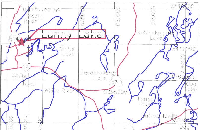
5 5 1. INTRODUCTION At the request of Mr. Brian Fowler, a Magnetic survey was performed on the Lunny Lake Property. The geophysical survey was carried out in April 2007 and it included a Mag survey over various grid lines. The survey grid totalled 6.7 km. This property is locatedin the Archean Schreiber-Hemlo Greenstone Belt that is part of the Abitibi-Wawa Shebandowan Subprovince of the Superior Province. The grid was cut to cover a base metal target and three (3) showings. A magnetic survey was performed over the grid are to highlight areas of mineralization. 2. PROPERTY, LOCATION AND ACCESS The Lunny Lake Property is located in the Wabicoba Lake area of the Thinder Bay Mining District, approximately 16 km northeast of the three producing Hemlo Gold Mines and 330 km east of Thunder Bay. The property can be accessed by the Dead Otter Lake/Twist Lake roads at a point about three kilometres east northeasterly of the Property. Figure 1. Localization of the Lunny Lake Property
6 6 3. CLAIMS The Lunny Lake property consists of 1 claim block of 16 claim units located in the Wabicoba Lake are of the Thunder Bay Mining District, approximately 16 km northeast of the three producing Hemlo Gold Mines. List of Claims T.B Registered in the name of Brian Fowler (100%). 4. PERSONNEL AND INSTRUMENTATION The following instruments were used for the Magnetometer survey: Two Scintrex ENVI Proton Magnetometers, a mobile and base station. 5. INSTRUMENTATION Model: Type: Total Field Range: Total Feld Accuracy: Sensitivity: Sample Rate: Tuning: Reading Period: Cycle Time: Cycle Delay: Data Acquisition System: Scintrex ENVI MAG sensor Part Number proton magnetometer, Part Number ,000 to 100,000 nt. ± 1 nt. 0.1 nt at 2 second reading time, reduced at other reading times. 2 per second Fully solid state. Manual or automatic; keyboard selectable 0.5, 1, or 2 seconds External - any, as long as it exceeds the reading period and is initiated by a command at the RS-232 interface. minimum determined by the reading - 8 sec in 1 ms intervals LCD 8 by 40 Super-twist electronics console, Part Number
7 7 Data Memory: Data Presentation: Data Output Format: Power Supply: Environmental Range: 151, ,000 readings Up to 178 readings in graphic mode. Data dump in memory or on a line by line basis in digital or hardcopy formats. 2.3 Ah Lead Acid battery. 12 V at 0.65 Amp -40 to 60 C. Humidity 0-100% Fully sealed desiccant cartridge. 6. BASE STATION Same as above (section 5) except for; Cycle Time: Data Memory: Internal - minimum is determined by the reading period, max 9999 sec in 1 sec intervals 28, ,000 readings. Power Supply: 12 V external battery The base station was located approximately 50 m away from the edge of a base cabin at coordinates approximately E and N (UTM ZONE 16 NAD 83). The base station magnetometer recorded the diurnal variations of the earth's magnetic field each day. The base station clock was synchronized with that of the mobile ground magnetometer to permit subsequent removal of diurnal drift. 7. SENSOR ORIENTATION Optimal signal strength was achieved by orienting the base station and the portable sensor along magnetic north. The Scintrex ENVI MAG proton magnetometers require that the sensors be aligned along magnetic north for maximum field strength coupling during data acquisition.
8 8 8. SIGN CONVENTION All survey lines in the claim ran in an North South direction. A positive (North and East) and negative (South and West) sign convention was adopted for all survey readings. 9. DIURNAL CORRECTIONS Diurnal variations caused by atmospheric effects such as ionospheric activity were accounted for in the data each day by correcting the mobile data against base station data. Magnetic corrections were part of daily QCIQA data checks. 10. FIELD WORKSTATION A Intel P4 laptop was used onsite to verify data quality and completeness. Base stations and mobile readings were transferred from the ENVI data consoles to a laptop and imported as xyz's into a Geosoft Oasis Montaj database. The database enabled visual on screen display of both positional and geophysical data for quality control purposes. Lastly, the report was written by Mike Vumbaca B.Sc. and Pierre Simineau, geol. M.Sc. The maps were drawn up by Pierre Simoneau. 11. PREVIOUS WORK The following companies have worked in the general area of the Lunny Lake Property, namely: Cecil Von Klein and his associates staked 134 claims and the property was optioned to McIntyre Porcupine Mines Ltd. The company carried out a program of linecutting, geological mapping, and ground geophysical surveys in the past. Discovery of a number of copper-nickel and copper-lead-zinc occurrences. Electromagnetic conductors and magnetic anomalies were teseted with 28 diamond drill holes. Good copper, zinc, silver, gold and lead values were obtained from drill holes around #4 showing. Caravelle Mines Ltd. acquired control of the McIntyre property and called it the Pulfa prospect. The Pulfa prospect consists of 253 contiguous claims. Associated companies have carried out evaluation work over the area in the past. The work consisted of photo-geological and aeromagnetic interpretations, reinterpretation of previous information, geochemical soil surveys, ground electromagnetic, magnetic, and IP surveys, geological
9 9 mapping and drilling. Most of the drilling was focussed around the #4 Showing and the A Zone. Caravelle confirmed the results obtained by McIntyre under the #4 Showing Geologists of the Geological Branch, Ontario Department of Mines carried out field mapping of the Black River Area during the various summer seasons (Milnes 1968). A combined airborne geophysical survey was flown between June 11 th and 13 th for Caravelle Mines Ltd. By Se1co Exploration Company Ltd. With a Mark IV INPUT and 200 meters spacing and variable line directions. A number of weak anomalies were detected. Arrangements for further developments on the mining property were taken with Fa1conbridge Nickel Mines, dated January 31 st, A ground magnetic and AFMAF-Longwire surveys were carried out over the claims by Central Geophysics Limited of Winnepeg. Some diamond drill holes were done but the claims were dropped. Noranda Exporation Co. Ltd. Completed an airborne survey and some geological mapping, Magnetics and VLF. Noranda Exporation Limited carried out further drilling in the area. Seven drill holes were completed, numbered PN-1 to PN-7. Drilling was focussed around the #4 Showing and to the south thereof. Noranda confirmed the values obtained by McIntyre and Caravelle under the #4 Showing. Noranda also drilled several holes south and southeast ofthe #4 Showing. Holes PN-2 under the #4 Showing returned 1.5m assaying 0.69% copper, 0.93% zinc and g silver per ton. 12. REGIONAL GEOLOGY The Lunny Lake Property is located within the Archean Schreiber-Hemlo Greenstone Belt that is part of the Abitibi-Wawa-Shebandowan Subprovince. The Black River area is underlain by an assemblage of Archean greenstones, intruded by granitic plutonic rocks. The mafic metavolcanics formation, which includes pillowed units, has been interpreted as the oldest and lowermost horizon of a gradational sequence. The mafic metavolcanics grade upward into intermediate metavolcanics, felsic metavolcanics, pyroclastic rocks (agglomerates) and sediments. The property is situated on the northern portion of the synform and dominated by east-west striking sequences of metavolcainic and sedimentary rocks bounded to the south by the Lusher Lake Pluton.
10 PROPERTY GEOLOGY The Lunny Lake property is underlain by Mafic metavolcanic rock from the lowermost stratigraphic unit and consists of pillowed flows which grade into fine to medium and medium to course grained amphibolites. Tops determination taken from pillows indicates a south younging direction. Interflow sediments, tuff and iron formation are found intermixed within the mafic flow. A calcsilicate unit intermixed with felsic to intermediate flows and pyroclastic rocks overlies the mafic volcanic. The sequence grades in tum into a thick succession of metasediments consisting essentially of conglomerates and greywacke. Locally, the emplacement of the Dotted Lake Pluton has produced a large easterly plunging anticline. The Theresa Lake property is located on the southern limb of this structure. Three parallel interflow sedimentary units have been traced in a fairly continuous fashion across the entire property. These units consist of laminated greywacke, arkose, argillite, calcareous mafic to felsic volcanogenic sediments and tuffs and fine-grained amphibolite interbedded with chert, banded sulphide and banded magnetite-amphibole. Though these units could be labelled as iron formations, banded magnetite probably accounts for less than 5% of the sequence in each unit. Each unit contains highly anomalous amounts of gold mineralization, as well as minor chalcopyrite, sphalerite, and molybdenite. The lowermost unit is in contact with the Armand Lake Porphyry. They vary in thickness from 15 meters to less than 1 meter. Compositionally, they are quartz-feldspathic, probably derived from exhalative chert, siltstones or clay beds. 14. FIELD WORK AND PROCEDURE The geophysical operator moved to the property and the grid was done from mid to late April The lines were cut and gridded with a 25m long chain. The grid extends E-W with N-S lines from 6+00W to 0+00 with 100 meter line to line spacing, and from 0+00 to 4_50E and from 7+00E to 9+00E, with 50 meters between each set of lines. A baseline intersects the grid at 4+50N. The magnetic survey covered the lines of the grid for a total of 6.7 km. Measuremnets were taken every 25 meters between stations. 15. MAGNETIC SURVEY 15.1 PURPOSE OF THE MAGNETIC SURVEY AND METHODOLOGY Magnetic surveys are useful in exploration as magnetic anomalies mostly represent changes in the physical properties of subsurface rocks. The property of a rock determines its magnetic effects and the intensity of its magnetization. During a survey, the total magnetic field is measured and a total field map is processed and produced that allows for the definition of both near-surface magnetic bodies.
11 11 The measurements for the magnetic total field were taken at a two (2) second sampling rate between a 25 m station to station spacing interval along all lines PRESENTATION OF THE RESULTS Geophysical data were processed and presented on maps using the computer software programs; Geosoft and MicroStation. The magnetic results are presented on a profile map (no. 1) and a total field contour map (no. 2) at the metric scale of 1: The profiles appear as red lines at a vertical scale of 1000 gammas per centimetre, with a base value of 0 gammas RESULTS OF THE MAGNETIC SURVEY The property magnetic background is around 57,700 gammas with a maximum of 60,879 gammas and a minimum of 54,290 gammas. The Magnetic colour contour map shows a main Iron Formation south of the Base line at aroud 3+25N and seems to continue but weaken on lines 7+00N to 9+00N anround 4+50 N. The total field results have provided three (3) magnetic horizons with a predominant northwest-southeast trend. At least four (4) thin high linear magnetic anomalies cross the grid area. These features may possibly be related to thin iron formations. 16. DISCUSSION OF THE GEOPHYSICAL RESULTS The geophysical survey covers gold bearing zones. The grid extends 1500 meters in length to cover zones 2, 4 and 5 and the area in between. The survey area is characterized by a series of high magnetic anomalies that may correspond to iron formations that appear to cross the grid. One VLF anomaly appears to coincide well with the main Mag Axis and could be characterized by sulfides CONCLUSION and RECOMMENDATIONS The Magnetic survey gives a good image of the geology and helps to discriminate numerous magnetic horizons. In particular, one of the magnetic layers corresponds to a VLF anomaly that could be related to a sulphide bearing zone. Prospecting and sampling should be followed up with an emphasis on the areas of higher magnetism. A closer station to station spacing of 10m or 12.5m would enhance the higher frequency and shallower wavelengths in the order of five (5) meters. A tighter, more detailed survey should be run in the future to enhance smaller scale anomalies, less than five (5) meters. A detailed survey would confirm the ground truth of any longer wavelength anomalies.
12 13 APPENDIX A Claim Maps and Abstract
13 586000E I N--- -\-0, I E UTMZone 16 H)OOm grid
14 14 CERTIFICATE of QUALIFICATIONS I, Michael Vumbaca do hereby certify that: 1. I have graduated with a B.Sc. Degree in Geophysics from University of Toronto, Toronto, Ontario in 1994 and a diploma in Environmental Engineering (in progress, 2008) from Humber College Institute of Applied Technology. 2. I am a practicing consulting mineral and environmental geophysicist resident in Toronto, Ontario. 3. I have been actively consulting in the environmental and mineral exploration industry in and across Canada and internationally since I am presently the owner and director of Mountain Valley Geophysics Corp. of 15 Hunting Ridge Drive, Toronto, Ontario. 4. I own no direct, indirect or expect to receive any contingent interests in the subject property or shares or securities from Mr. Brian Fowler. 5. The information contained in this report was obtained from the geophysical magnetic survey conducted on the Killala Lake property carried out by Michael Vumbaca and informations obtained from the Assessment files and from Brian Fowler. 6. I am a member in progress of the Professional Geoscientists of Ontario (P.Geo), a member of the Canadian Exploration Geophysics Society (KEGS) and Associated Environmental Assessors of Canada (ASAC). 7. I have disclosed in this report all relevant material which, to the best of my knowledge, might have a bearing on the viability of the project and the recommendations presented. 8. I consent to the use of this report by Mr. Brian Fowler for any Filing Statement, Statement of Material Facts, Prospectus, filing of assessment work of for any other reason deemed necessary by the company, Dated at Toronto, this 21 st day of August, Respectfully submitted, Michael Vumbaca, B.Sc. Principal and Geophysicist 15 Hunting Ridge Drive Etobicoke, Ontario Canada M9R IB6

15


16
GEOPHYSICAL REPORT FOR BRIAN D. FOWLER SUPERIOR PROSPECTS INC. ON CLAIM WABICOBA LAKE TOWNSHIP (G-0620) MARATHON, ONTARIO
 MARATHON, ONTARIO") mountain valley geophysics Report # 1 0021 GEOPHYSICAL REPORT FOR BRIAN D. FOWLER SUPERIOR PROSPECTS INC. ON CLAIM 4208397 WABICOBA LAKE TOWNSHIP (G-0620) MARATHON, ONTARIO Chief Red Sky Property NTS:42C/13SW
mountain valley geophysics Report # 1 0021 GEOPHYSICAL REPORT FOR BRIAN D. FOWLER SUPERIOR PROSPECTS INC. ON CLAIM 4208397 WABICOBA LAKE TOWNSHIP (G-0620) MARATHON, ONTARIO Chief Red Sky Property NTS:42C/13SW
Report of Gridding and Magnetic Surveys. On the. Munro Property. Munro and Beatty Townships, Ontario. Larder Lake Mining Division
 Report of Gridding and Magnetic Surveys On the Munro Property Munro and Beatty Townships, Ontario Larder Lake Mining Division Claims: 39 4244 For Big Red Diamond Corporation October 3, 2 Timmins, Ontario
1 CLAIMS GEOPHYSICAL REPORT ON BOYAL SITUATE NORTHEAST OF TILLICUM MOUNTAIN GOLD AREA BURTON - NAKUSP SIQCAEJ MINING DIVISION
 GEOPHYSICAL REPORT ON BOYAL 1 CLAIMS SITUATE NORTHEAST OF TILLICUM MOUNTAIN GOLD AREA BURTON - NAKUSP SIQCAEJ MINING DIVISION CONSULTING GEOLOGIST AUGUST 1983 VANCOUVER B *C INDEX INTRODUCTION ooa,.eoaaa.aaaoaaooaoa~ao~o
Total Magnetic Field and VLF Surveys on the Swayze Property. Claim Swayze Township. Porcupine Mining Division
 1 January, 016 NTS: 041 O 15 Total Magnetic Field and VLF Surveys on the Swayze Property Claim 475471 Swayze Township Porcupine Mining Division 380850E, 599450N UTM Z17N NAD83 Report Prepared for: 540
PIOTR LUTYNSKI VANCOUVER, BRITISH COLUMBIA
 AN ASSESSMENT REPORT ON GROUND MAGNETIC SURVEYING CHUCHI PROPERTY FORT ST. JAMES AREA, BRITISH COLUMBIA OMINECA M.D. 55 17 N, 124 31 W NTS 93N/ 7&8 Claims Surveyed: 597976, 597878-597880 Survey Dates:
Introducti on. Land Survey. Geomagnetic Survey. Geomagnetic Results and Interpretati ons - Conclusions and Recommendations C
 m M 42A86SW8281 63.42 PRICE 010 C O H T E H l 42A86SW828I 63.42 PRICE 010C Introducti on Land Survey Geomagnetic Survey Geomagnetic Results and Interpretati ons - Conclusions and Recommendations - - -
SUMMARY REPORT. RE-ESTABLISH CLAIM BOUNDARY (Claim ) CARR TOWNSHIP (Larder Lake Mining Division) NTS (42 Al09) FOR
 CARR TOWNSHIP (Larder Lake Mining Division) NTS (42 Al09) FOR") 2.44330 " SUMMARY REPORT RE-ESTABLISH CLAIM BOUNDARY (Claim 3002288) CARR TOWNSHIP (Larder Lake Mining Division) NTS (42 Al09) FOR ST ANDREW GOLDFIELDS LTD. ""'1,.I Les 1. Kovacs, P. Geo For: St Andrew
2.44330 " SUMMARY REPORT RE-ESTABLISH CLAIM BOUNDARY (Claim 3002288) CARR TOWNSHIP (Larder Lake Mining Division) NTS (42 Al09) FOR ST ANDREW GOLDFIELDS LTD. ""'1,.I Les 1. Kovacs, P. Geo For: St Andrew
REPORT ON DIAMOND DRILLING SUBSTITUTION EAST PROPERTY CLAIMS AND HEBERT TOWNSHIP ONTARIO, CANADA
 REPORT ON DIAMOND DRILLING SUBSTITUTION EAST PROPERTY CLAIMS 1248920 AND 1248921 HEBERT TOWNSHIP ONTARIO, CANADA Adroit Resources Inc. Suite #610-1111 Melville Street Vancouver, British Columbia, Canada
SUPPLEMENT TO MAGNETOMETER 6 ELECTROMAGNETIC SURVEY REPORT. DATED NOVEMBER l, 1973 CIGLEN INVESTMENTS LIMITED CLAIMS GROUP BAD VERMILLION LAKE AREA
 ^ A R l ^ 1974 010 PROJECTS UNIT SUPPLEMENT TO MAGNETOMETER 6 ELECTROMAGNETIC SURVEY REPORT DATED NOVEMBER l, 1973 CIGLEN INVESTMENTS LIMITED CLAIMS GROUP BAD VERMILLION LAKE AREA DISTRICT OF RAINY RIVER
ASSESSMENT REPORT ON THE PEAVINE PROJECT. DGW & Associates # Alberni Street, Vancouver, British Columbia, V6E 4V2
 ASSESSMENT REPORT ON THE PEAVINE PROJECT KAMLOOPS MINING DIVISION BRITISH COLUMBIA NTS 082M 12 Latitude 51 36' 19.0"North -- Longitude --119 47' 27.0"West UTM Zone 11, NAD 83 5720827N 306744E Prepared
We are committed to providing accessible customer service. If you need accessible formats or communications supports, please contact us.
 We are committed to providing accessible customer service. If you need accessible formats or communications supports, please contact us. Nous tenons à améliorer l accessibilité des services à la clientèle.
Assessment Report by the Canadian Nickel Co. Ltd. Magnetometer Survey. Larder Lake Mining Division Lebel Tovnship, Ontario
 32084Nwea67 2.331* LEBEL 010 Assessment Report by the Canadian Nickel Co. Ltd. Magnetometer Survey Larder Lake Mining Division Lebel Tovnship, Ontario Claims L-531657 L-531658 L-531111 Map No.: M-359,
Grassroots Exploration for Gold in Labrador
 Grassroots Exploration for Gold in Labrador Roger Moss, Nikos Explorations Ltd., Shawn Ryan, RyanWood Exploration, John Clarke, GroundTruth Exploration. Mineral Resources Review November 1 st -4 th 2017
compietea since tnat date, and wnicn comprisea btage I ot tne recommended
 compietea since tnat date, and wnicn comprisea btage I ot tne recommended four-stage program. GEOLOGY & MINERALIZATION The property situate6 on the southeast slope of Nickel Plate Mtn., and within the
Pacific Empire Minerals Provides Copper King RC Drilling Results
 Pacific Empire Minerals Provides Copper King RC Drilling Results November 1, 2018 - Vancouver, BC, Canada - Pacific Empire Minerals Corp. (TSXV: PEMC) ( Pacific Empire, PEMC or the Company ), a hybrid
COMBINATION OF MMI AND ENZYME LEACH METHODS IN EXPLORATION FOR GOLD IN AN AREA OF THE CANADIAN SHIELD COVERED WITH GLACIAL SEDIMENTS: A CASE STUDY
 COMBINATION OF MMI AND ENZYME LEACH METHODS IN EXPLORATION FOR GOLD IN AN AREA OF THE CANADIAN SHIELD COVERED WITH GLACIAL SEDIMENTS: A CASE STUDY Nadia Yavorskaya 450 Bonner Ave., Winnipeg, MB, Canada
Summary of Rover Metals Geologic Mapping Program at the Up Town Gold Project, Northwest Territories
 October 13, 2017 Summary of Rover Metals Geologic Mapping Program at the Up Town Gold Project, Northwest Territories Vancouver, British Columbia, Canada - Rover Metals Corp., Rover, is pleased to provide
Interpretation Report on Borehole TDEM Surveys
 Interpretation Report on Borehole TDEM Surveys Junior Lake Property, Armstrong, Ontario For Landore Resources Canada Inc. Alan R. King, M.Sc., P.Geo. January 25, 2016 Introduction Alan King of Geoscience
The Cobalt Rainbow. Airborne geophysical maps show that a north trending aeromagnetic high suggests further undiscovered mineralisation.
 The Cobalt Rainbow The property is located on Greenstone Creek, approximately 4.8 kilometres south west of the creek mouth. The property is located about 24 km due west of Campbell River, in the east-central
Detour West Gold Project Technical Overview. April, 2018
 Detour West Gold Project Technical Overview April, 2018 Detour West Project Overview Detour West is a 7,680 hectare property located at the northwest margin of the Abitibi Greenstone Belt, 20 km west of
MAGNETIC SURVEY REPORT. on the O'BRIEN CLAIM GROUP. Deloro Township Porcupine Mining Division, Ontario. for PAMOUR PORCUPINE MINES LIMITED
 42A06NE0456 2.7439 DELORO 010 MAGNETIC SURVEY REPORT on the O'BRIEN CLAIM GROUP Deloro Township Porcupine Mining Division, Ontario as se C/J 1* m O for PAMOUR PORCUPINE MINES LIMITED by Kian A. Jensen,
Burchell Lake, A Copper, Gold and Molybdenum Property In Ontario. Corporate Presentation September, 2013
 Burchell Lake, A Copper, Gold and Molybdenum Property In Ontario Corporate Presentation September, 2013 Background Tanager Energy Inc. is a Canadian corporation whose shares are traded on the TSX Venture
PROSPECTING Survey Over the AULD PROPERTY Auld Township, Ontario
 PO Box 219, 14579 Government Road, Larder Lake, Ontario, P0K 1L0, Canada Phone (705) 643-2345 Fax (705) 643-2191 www.cxsltd.com PROSPECTING Survey Over the AULD PROPERTY C Jason Ploeger, B.Sc, P.Geo August
The MAPLE BAY PROJECT Copper Silver - Gold
 The MAPLE BAY PROJECT Copper Silver - Gold Good grade and tonnage potential within close proximity to Tidewater The Maple Bay Copper Silver Gold Project covers highly favourable geological host rocks of
Fox 2-Record No. 2524
 F HELICOPTER E.M. AND MAGNETOMETER SURVEY OVER THE FOX CLAIMS, OMINECA MINING DISTRICT BRITISH COLUMBIA ON BEHALF OF OWNER MR. MIKE BOYLE Claims: Fox l-record No. 2523 Fox 2-Record No. 2524 Location 126'
CHAMPION IRON REPORTS EXPLORATION RESULTS AT POWDERHORN PROJECT, NEWFOUNDLAND
 PRESS RELEASE CHAMPION IRON REPORTS EXPLORATION RESULTS AT POWDERHORN PROJECT, NEWFOUNDLAND Confirmed Continuity of High-Grade Zinc Zone and Addition of Gold to the Expanded Copper Zone Montreal, March
State Metallic Minerals Lease Sale Minnesota s Vermilion Gold District
 State Metallic Minerals Lease Sale Minnesota s Vermilion Gold District State Metallic Minerals Lease Sale Notice of Intent Scale 1:100,000 State Metallic Minerals Lease Sale This portion of the lease sale
NT RESOURCES LIMITED QUARTERLY ACTIVITIES REPORT FOR THE PERIOD ENDED 30 JUNE 2010 ASX CODE: NTR
 NT RESOURCES LIMITED QUARTERLY ACTIVITIES REPORT FOR THE PERIOD ENDED 30 JUNE 2010 ASX CODE: NTR Activities Report Background NT Resources Limited ( NT Resources or the Company ) holds six granted Exploration
Mineral Resource Estimate Comparison at 3 g/t Au cut-off
 HARTE GOLD CORP. 8 King Street East, Suite 1700 Toronto, Ontario, M5C 1B5 Tel: 416-368-0999 Fax: 416-368-5146 Harte Gold Announces 2018 Drilling Increases Indicated Mineral Resources by 55% Overall Resource
CJP EXPLORATION INC.
 PO Box 219 14579 Government Road Larder Lake, Ontario P0K 1L0, Canada Phone (705) 643-1122 Fax (705) 643-2191 CJP EXPLORATION INC. Spectrometer Survey Over the SHEBA PROPERTY Nouvel Township, Ontario TABLE
Mishi Lake Gold Property Mishibishu Lake Area, Wawa
 Mishi Lake Gold Property Mishibishu Lake Area, Wawa Location, Accessibility, Infrastructure and Local Resources The property is located 40 km west of Wawa, Ontario, in the Mishibishu Lake Area, Sault Ste.
National Instrument Technical Report
 National Instrument 43-101Technical Report Pigeon River Property Hartington Township Ontario, Canada Thunder Bay Mining Division, NTS 42A4 Geology Updated Technical Report UTM: Zone 16, 277134m E, 5332229m
We are committed to providing accessible customer service. If you need accessible formats or communications supports, please contact us.
 We are committed to providing accessible customer service. If you need accessible formats or communications supports, please contact us. Nous tenons à améliorer l accessibilité des services à la clientèle.
4. Geological maps published by the Ontario Department of Mines.
 52J08NWei45 S2J08NWa6B1 SMYE 010 AMALGAMATED RARE EARTH MINES LTD. *, SAVANT LAKE PROSPECT x ONTARIO INTRODUCTION t This Is a report on a group of 28 claims control led by Amalgamated Rare Earth Mines
2014 AEROQUEST AIRBORNE HELI-BORNE VTEM PLUS AND HORIZONTAL MAGNETIC GRADIOMETER SURVEY ASSESSMENT REPORT CAMERON GOLD PROJECT
 2014 AEROQUEST AIRBORNE HELI-BORNE VTEM PLUS AND HORIZONTAL MAGNETIC GRADIOMETER SURVEY ASSESSMENT REPORT CAMERON GOLD PROJECT PREPARED BY: Nick Walker. January 2015 SUMMARY This report presents the results
PROSPECTORS ASSISTANCE PROGRAM MINISTRY OF ENERGY AND MINES
 BRITISH COLUMBIA PROSPECTORS ASSISTANCE PROGRAM MINISTRY OF ENERGY AND MINES GEOLOGICAL SURVEY BRANCH PROGRAM YEAR: 1999/2000 REPORT #: PAP 99-l 6 NAME: KIM ANSCHETZ PROSPECTORS TlEPORT on the 99 LOUIS
CONTENTS. Location, Access and History...6. Tenure Status and Geology Regional Andy Property Geology Map...9
 TYPE OFWORK IN THIS REPORT EXTENT OF WORK (rn METRTC UNITS) ON WHICH CLAIMS PROJECT COSTS APPORTIONED (incl. support) GEOLOGICAL (scale, area) Ground, mapping Photo interpretation GEOPHYSICAL (line-kilometres)
Scadding Property Sudbury District, Ontario
 FOR IMMEDIATE RELEASE Northern Sphere Mining Corp. optimizes mineral targets on its Sudbury Nickel Belt and Arizona Porphyry Copper properties Toronto, Ontario April 5, 2018 - Northern Sphere Mining Corp.
TECHNICAL REPORT ON THE BLACK CREEK PROPERTY FOR CARRIE ARRAN RESOURCES BLACK TOWNSHIP LARDER LAKE MINING DIVISION ONTARIO
 TECHNICAL REPORT ON THE BLACK CREEK PROPERTY FOR CARRIE ARRAN RESOURCES BLACK TOWNSHIP LARDER LAKE MINING DIVISION ONTARIO B.J. McKay, 8 February 2011 Keewatin, Ontario TECHNICAL REPORT BJML 2011 Table
Toronto, Ontario November 16, This report may not be reproduced, in whole or in part, without the written permission of Derry, Michener S Booth.
 13 2.1354 L ITTLE 010 GEOPHYSICAL SURVEYS, LITTLE TOWNSHIP CLAIM GROUP OB-F TIMMINS AREA PORCUPINE MINING DIVISION, ONTARIO Toronto, Ontario November 16, 1973 This report may not be reproduced, in whole
Report of Induced Polarization Surveys and. Total Field Magnetic Surveys. Turtle Pond, Emmons Lake, Prig, North Glatz, Glatz, and Double E Grids
 Report of nduced Polarization Surveys and Total Field Magnetic Surveys On the Turtlepond Project Turtle Pond, Emmons Lake, Prig, North Glatz, Glatz, and Double E Grids Turtlepond Lake Area, Ontario Claim
CARIBOO - GRIZZLY ZINC PROJECT
 CARIBOO - GRIZZLY ZINC PROJECT The Grizzly Lake or Cariboo Zinc property straddles the gravel Weldwood 8400 logging road in the Grizzly Lake area about 55 kilometres northeast of Likely. Roads constructed
NEWS RELEASE FOR IMMEDIATE RELEASE: MARCH 5, 2018
 NEWS RELEASE FOR IMMEDIATE RELEASE: MARCH 5, 2018 Eskay Mining provides update on ongoing geological review - Targeting E&L-Type Nickel-Copper-PGE and Eskay-Type VMS Potential on Its Golden Triangle Holdings:
Processing and Enhancement of East Kemptville Airborne Magnetometer Survey
 M I N E R A L R E S O U R C E S B R A N C H Processing and Enhancement of East Kemptville Airborne Magnetometer Survey Open File Report ME 2006-1 M. S. (Steve) King Honourable Brooke D. Taylor Minister
2013 GEOLOGICAL ASSESSMENT REPORT SHERIDAN HILL PROPERTY
 2013 GEOLOGICAL ASSESSMENT REPORT ON THE SHERIDAN HILL PROPERTY NEW WESTMINSTER MINING DIVISION BRITISH COLUMBIA NTS 092G07 49 16 31 NORTH LATITUDE, 122 39 48 WEST LONGITUDE PREPARED FOR Sheridan Hill
for the Greenwood Mining Division, B.C. NTS 82E/7W Latitude 49' 27' W, Longitude 118' 5 Prepared by a= D. Dylan Watt, B.Sc.
 t. b LOGnO: 37~ -08 m. ACTIO#: for the AMP AMP 2 AMP 3 t AMP 4 CLAIMS Greenwood Mining Division, B.C. NTS 82E/7W Latitude 49' 27' W, Longitude 8' 5 %E c,w zc *& a w Prepared by a= -4c. D. Dylan Watt, B.Sc.
ASX Announcement. 28 January Drill results indicate large Porphyry Copper Gold System at Peenam
 ASX Announcement 28 January 2010 Drill results indicate large Porphyry Copper Gold System at Peenam Highlights: 270 metres of visible copper (gold) mineralisation in first diamond core hole at Peenam Prospect
We are committed to providing accessible customer service. If you need accessible formats or communications supports, please contact us.
 We are committed to providing accessible customer service. If you need accessible formats or communications supports, please contact us. Nous tenons à améliorer l accessibilité des services à la clientèle.
DÉCOUVERTE Positioned for Discovery in James Bay, Quebec. Investor Presentation, January 2018 by Danae Voormeij, MSc, PGeo
 DÉCOUVERTE Positioned for Discovery in James Bay, Quebec Investor Presentation, January 2018 by Danae Voormeij, MSc, PGeo Location Maps and Infrastructure Location: Durango Resources 100% owned Découverte
704,000 OUNCE MIYABI GOLD PROJECT UPDATE
 704,000 OUNCE MIYABI GOLD PROJECT UPDATE ASX/ RELEASE 21 April 2016 ASX code RVY Board of Directors: Geoff Gilmour Managing Director Greg Cunnold Technical Director Graeme Clatworthy Non-Executive Director
POTENTIAL OF THE DONGWE COPPER GOLD PROJECT
 POTENTIAL OF THE DONGWE COPPER GOLD PROJECT By Nathan Sabao, P.Geo. September 2015 1 TABLE OF CONTENTS Page 1.0 EXECUTIVE SUMMARY 1 2.0 LOCATION 2 3.0 ACCESS 2 4.0 GEOLOGY 3 5.0 PREVIOUS DRILLING 5 6.0
CHAMPION BEAR RESOURCES
 CHAMPION BEAR RESOURCES EXPLORING ADVANCED STAGE PRECIOUS METAL PROPERTIES IN ONTARIO Exploration Update January 2011 Forward Looking Statements This exploration update contains forward looking statements
Report on The Magnetic Survey. Property of Loydex Resources Inc. Keigat Lake Area. Red Lake Mining Division
 010 Report on The Magnetic Survey On The Property of Loydex Resources Inc. SANDY POINT PROJECT Keigat Lake Area District of Kenora, Patricia Portion Red Lake Mining Division N.T.S. 52-N-8 Whitby, Ontario
For personal use only
 21 December 2017 MASSIVE SULPHIDES INTERSECTED IN DRILLING 15 hole, 2270m diamond drill program completed at Midrim Thick zones of massive sulphides intersected Core being logged and sampled with assays
NEWS RELEASE Ocean Park Ventures Identifies Large Multi-Structure Sulfide Mineralized System Trapper Gold Project, British Columbia
 Suite 302 750 West Pender St Vancouver, BC V6C 2T7 Tel: 604-681-0084 Fax: 604-681-0094 www.oceanparkventures.com TSX-V SYMBOL: OCP NEWS RELEASE Ocean Park Ventures Identifies Large Multi-Structure Sulfide
for the Greenwood Mining Division, B.C. NTS 82E/7W 29' W, Longitude 118' 53' N Prepared by D. Dylan Watt, B.Sc.
 for the FltE NO: u VOLT 1, VOLT 2, VOLT 3, & VOLT 4 CLAIMS Greenwood Mining Division, B.C. NTS 82E/7W Latitude 49' 29' W, Longitude 118' 53' N Prepared by D. Dylan Watt, B.Sc. #309-1996 Trutch Street Vancouver,
COMINCO LTD. HORIZONTAL LOOP EM AND MAGNETIC SURVEYS ON SHA. CLAIMS 1, 2, 7 and 8 NELSON AND FORT STEELE MINING DIVISIONS, B.C.
 COMINCO LTD. EXPLORATION WESTERN DISTRICT NTS: 82-F/1 HORIZONTAL LOOP EM AND MAGNETIC SURVEYS ON SHA CLAIMS 1, 2, 7 and 8 - ASSESSMENT REPORT - NELSON AND FORT STEELE MINING DIVISIONS, B.C. Latitude Longitude
42H88SW NEWMAN
 42H88SW0003 63.8199 NEWMAN 010 TRIPOINT MINES LIMITED, Suite 305-100 Adelaide St. West, Toronto l, Ontario. Gentlemen: Your Company recently conducted a combined magneticelectromagnetic survey over a ten
GEOLOGICAL BRANCH ASSESSMENT REPORT 12. FItE NO: ACTION: THE GOLDEN MINING DIVISION, GOLDEN, Including THE NTS MAP; M82K/15W
 ACTION: FItE NO: Including 1990 GEO-CHEM SURVEY RESULTS -- THE AVD CLAIMS - THE GOLDEN MINING DIVISION, GOLDEN, B.C. NTS MAP; M82K/15W Lat. 50 deg. 55 Min. Long 116 deg. 55 min. For GEOLOGICAL BRANCH ASSESSMENT
The survey covered claims, in part or in full, DUCKLING 3, 4, 5, 4 fraction, and 5 fraction.
 514 687-6671 XXX- 602 West Hastin~a StroeP, Vata;sn@ouver, BritlsA fhlum~b~a, Garaadsa B81apphgtaa DISCUSS ION OF MAGNETOMETER SURVEY ON DUCKLING CLAIMS FOR DONNA MINES LTD. (N0P.L.) Submitted to: DONNA
For personal use only
 ANNOUNCEMENT TO THE AUSTRALIAN SECURITIES EXCHANGE: 28 NOVEMBER 2012 DRILLING UPDATE MABILO PROJECT The Directors of Sierra Mining Limited ( Sierra ) are pleased to announce further results from reconnaissance
GEOLOGICAL MAPPING REPORT ON THE ASH MINERAL CLAIM OSOYOOS MINING DIVISION ASHNOLA RIVER MAP SHEET NTS M092,H019 MCBRIDE CREEK AREA, ASHNOLA RIVER,
 GEOLOGICAL MAPPING REPORT ON THE ASH MINERAL CLAIM OSOYOOS MINING DIVISION ASHNOLA RIVER MAP SHEET NTS M092,H019 LATITUDE 49 o O6, LONGITUDE 120 o 22 MCBRIDE CREEK AREA, ASHNOLA RIVER, KEREMEOS, B.C. CANADA
Drilling Commences at Telfer West Gold Project
 Level 7, 600 Murray Street West Perth WA 6005 PO Box 273 West Perth WA 6872 P 08 9486 9455 F 08 6210 1578 www.enrl.com.au 17 November 2016 ASX : ENR Company Announcements Office Australian Securities Exchange
TIGER GOLD EXPLORATION CORPORATION. Prospecting Over the HARKER HERITAGE PROPERTY AREA 10. Harker Township, Ontario
 PO Box 219, 14579 Government Road, Larder Lake, Ontario, P0K 1L0, Canada Phone (705) 643-2345 Fax (705) 643-2191 www.cxsltd.com TIGER GOLD EXPLORATION CORPORATION Prospecting Over the HARKER HERITAGE PROPERTY
Discovering Canadian Gold and Diamonds. Oxford Lake Project, Manitoba
 Discovering Canadian Gold and Diamonds Oxford Lake Project, Manitoba March 2016 Forward Looking Statement Certain statements contained in this presentation may contain forward-looking information within
REPORT ON GEOPHYSICAL SURVEYS ON THE BAMAJI LAKE PROPERTY CROBIE PROJECT, NW ONTARIO OF UMEX INC.
 S20e3NWe«28 S20«3NWee37 FRY LAKE 0 1 0 REPORT ON GEOPHYSICAL SURVEYS ON THE BAMAJI LAKE PROPERTY CROBIE PROJECT, NW ONTARIO OF UMEX INC. Patricia Mining Division NTS 52 0/3 Latitude 51 10'N Longitude 91
John A. Wakeford Noranda Exploration Co., Ltd, November 4, 1980 rinnnins, Ontario
 42CC1NEfc4e9 801101 ECHUM 010 " ' i-^y&sg?' '.. -.r. K;VW\\:.!^-*.]-^--'^-r-r^Pj^Q..-. ;,: v 1,;-'-,..- ^^-^^^^ysr-r^ijjfiv^jj. v -." ". '. ' "i - '' '. '':.;': s.'.ilv'., p...--'*l r-j@tw IP ^vt'.'v*:-^
AND HORSEFLY PROSPECTS, N.W. BRITISH COLUMBIA NTS, 103H/ll, 14 FOR ATNA RESOURCES LTD DELTA GEOSCIENCE LTD
 AND HORSEFLY PROSPECTS, N.W. BRITISH COLUMBIA NTS, 103H/ll, 14 FOR ATNA RESOURCES LTD BY DELTA GEOSCIENCE LTD FE T A. HENDRICKSON, P.GEO. 1 . TABLE OF CONTENTS Introduction............. Page 1. Personnel..........
Gold Mountain Group Gold Mtn. A, B, C & D Mineral Claims Record Nos. 697, 698, 699 & 700. Island Mountain Cariboo Mining Division British Columbia
 GOLD POINT RESOURCES LTD. Geophysical Survey Gold Mountain Group Gold Mtn. A, B, C & D Mineral Claims Record Nos. 697, 698, 699 & 700 Island Mountain Cariboo Mining Division British Columbia Vancouver,
sq N & %%.& GEOPHYSICAL CONSULTING rr SERVICES LTD. $%& Long. 118o3OtW N.T.S. 82 E/15 -I- AUTROR: Glen E. Whi*e, B.Sc., P. %g.
 -\ GEOCHEMICAL EXPORT.,~.,~..'.. AMORE MINERALS 1NCORPOR;ITZC,' ~. 3rd fl5 Geo 3. and 2 mineral claims, Vernon- ~ $lining Division, B. C. Lat. 49 47'T?,,/ Long. 118o3OtW N.T.S. 82 E/15 -I- AUTROR: Glen
Project 81. Drill Ready Geophysical Targets & Trends. Timmins-Cochrane Northern Ontario Canada
 Project 81 Drill Ready Geophysical Targets & Trends Timmins-Cochrane Northern Ontario Canada FORWARD-LOOKING STATEMENT Certain statements contained in this presentation that are forwardlooking in nature
Prospecting Report 'S Office i DB Property, B.C. -J Negro Creek Nelson Mining District NTS 82F.050. Operator: Kootenay Gold Inc.
 . '.' I"' i9 12 Prospecting Report 'S Office i DB Property, B.C. -J Negro Creek Nelson Mining District NTS 82F.050 Operator: Kootenay Gold Inc. Owner: Darlene Lavoie Work Performed Summer of 2007 Report
Advancing High Grade Gold Assets in Red Lake, Ontario
 Advancing High Grade Gold Assets in Red Lake, Ontario Forward Looking Statement Except for historical information contained herein, this presentation may contain forward-looking statements including but
GEOPHYSICAL REPORT THE CAVZ CLAIMS
 GEOPHYSICAL REPORT Magnetometer Survey on THE CAVZ CLAIMS CAVZ M.C.'s 1 to 12, 15 to 26, 29 to 40, 45 to 54 Trail Peak, Omineca M.D. 13 miles northeast of Fort Babine 550 ) 126 S.E. by G.Podolsky J.Russell
HELICOPTER MAGNETIC SURVEY MISINCHINKA RANGE AREA, B.C. ONINECA MINING DIVISION. on behalf of STOKES EXPLORATION MANAGEMENT LTD.
 HELICOPTER MAGNETIC SURVEY MISINCHINKA RANGE AREA, B.C. ONINECA MINING DIVISION on behalf of STOKES EXPLORATION MANAGEMENT LTD. Claims : FALCON $1, FALCON #2 Location: Dated: About 7% kilometers N.E. of
BALTO RESOURCES LTD. (Owner & Operator) GEOPHYSICAL ASSESSMENT REPORT. (Event Number ) on the SED MINERAL CLAIM.
 GEOPHYSICAL ASSESSMENT REPORT. (Event Number ) on the SED MINERAL CLAIM.") BALTO RESOURCES LTD. (Owner & Operator) GEOPHYSICAL ASSESSMENT REPORT (Event Number 5173274) on the SED MINERAL CLAIM (Tenure 392163) Kamloops Mining Division NTS 092I.047 Centre of Work 5589550N, 667600E
BALTO RESOURCES LTD. (Owner & Operator) GEOPHYSICAL ASSESSMENT REPORT (Event Number 5173274) on the SED MINERAL CLAIM (Tenure 392163) Kamloops Mining Division NTS 092I.047 Centre of Work 5589550N, 667600E
Darnley Bay Resources Preliminary Airborne Survey Results
 4 King Street West, Suite 1103 Toronto, Ontario M5H 1B6, Canada Tel:(416) 862-7885 Fax:(416) 862-7889 dbr@darnleybay.com UPDATE Trading Symbol: DBL. TSX Venture Exchange April 19, 2010 Darnley Bay Resources
Gold Mineralization Potential in a Wabigoon Subprovince Granite-Greenstone Terrane, International Falls Area, Minnesota
 Gold Mineralization Potential in a Wabigoon Subprovince Granite-Greenstone Terrane, International Falls Area, Minnesota Manitoba Ontario Mn The State of Minnesota is located in the north-central portion
SUMMARY REPORT. ESSAR STEEL ALGOMA INC. 105 West Street, Sault Ste. Marie, Ontario, Canada P6A 7B4
 SUMMARY REPORT IRON LAKE PROPERTY Keating and Keating Additional Townships, Ontario, Canada ESSAR STEEL ALGOMA INC. 105 West Street, Sault Ste. Marie, Ontario, Canada P6A 7B4 Date: March 18, 2013 Prepared
Magnus Copper Project exploration update
 ASX ANNOUNCEMENT 30 SEPTEMBER 2011 CODE: ALY BOARD OF DIRECTORS Mr Warwick Davies Non-Executive Chairman Mr Robert Brierley Managing Director Mr John Arbuckle Non-Executive Director Mr Jeffrey Moore Non-Executive
ASX ANNOUNCEMENT 4 March 2019 VTEM SURVEY COMMENCED OVER LORRAINE AND ADZ PROJECT AREAS
 ASX ANNOUNCEMENT 4 March 2019 VTEM SURVEY COMMENCED OVER LORRAINE AND ADZ PROJECT AREAS The Company is pleased to announce the commencement of a detailed airborne electromagnetic geophysical survey over
BLURTON CREEK NICKEL PROPERTY. (Minfile # 082LNW-039)
") 5489153 BLURTON CREEK NICKEL PROPERTY (Minfile # 082LNW-039) Mara Lake Area / Salmon Arm B.C NTS - 82L-11 (UTM 83/Z10, 357690E, 5614220N) Prepared by: Jim Cuttle, B.Sc., P.Geo. 86 Cloudburst Road Whistler,
5489153 BLURTON CREEK NICKEL PROPERTY (Minfile # 082LNW-039) Mara Lake Area / Salmon Arm B.C NTS - 82L-11 (UTM 83/Z10, 357690E, 5614220N) Prepared by: Jim Cuttle, B.Sc., P.Geo. 86 Cloudburst Road Whistler,
Rockstar Gold Property Goudreau-Dog Lake Area, Wawa, Ontario. Argo Gold Inc. (ARQ)
") Rockstar Gold Property Goudreau-Dog Lake Area, Wawa, Ontario Argo Gold Inc. (ARQ) Location Map, Rockstar Gold Property Land Tenure, Rockstar Gold Property Regional Geology Michipicoten Greenstone Belt
Rockstar Gold Property Goudreau-Dog Lake Area, Wawa, Ontario Argo Gold Inc. (ARQ) Location Map, Rockstar Gold Property Land Tenure, Rockstar Gold Property Regional Geology Michipicoten Greenstone Belt
BALFOUR MINING LTD. (N.P.L.) HAM GROUP 92-P-6, CLINTON M. D.8 B. C. Lat 51 17'N, GEOCHEMICAL REPORT. V. CUKOR, P. Eng.
 HAM GROUP 92-P-6, CLINTON M. D.8 B. C. Lat 51 17'N, GEOCHEMICAL REPORT. V. CUKOR, P. Eng.") 34q '7 BALFOUR MINING LTD. (N.P.L.) HAM GROUP 92-P-6, CLINTON M. D.8 B. C. Lat 51 17'N, Long 12lo14'W GEOCHEMICAL REPORT, V. CUKOR, P. Eng. January 31, 1972 TABLE OF CONTENTS 1. INTRODUCTION 2. PROPERTY,
34q '7 BALFOUR MINING LTD. (N.P.L.) HAM GROUP 92-P-6, CLINTON M. D.8 B. C. Lat 51 17'N, Long 12lo14'W GEOCHEMICAL REPORT, V. CUKOR, P. Eng. January 31, 1972 TABLE OF CONTENTS 1. INTRODUCTION 2. PROPERTY,
FANCAMP EXPLORATION LTD.
 FANCAMP EXPLORATION LTD. Fancamp Exploration Ltd. Overview of Ontario Projects Prepared by: J. Kleinboeck, P.Geo. August 4 th, 2018 Dorothy Lake Project Comprised of 104 unpatented claims covering an
Copper Reef to Drill Massive Sulphide Targets in Flin Flon
 12 Mitchell Road Tel: (204) 687-3500 Flin Flon, MB, R8A 1N1 CZC.CSE Fax: (204) 687-4762 copperreef.com February 28, 2019. Copper Reef to Drill Massive Sulphide Targets in Flin Flon Copper Reef Mining Corporation
Report. On a 3D Magnetic Inversion. For. Cadillac Ventures Ltd. And. Newcastle Minerals Ltd. Pickle Lake Project. Ontario, Canada
 Report On a 3D Magnetic Inversion For Cadillac Ventures Ltd And Newcastle Minerals Ltd. Pickle Lake Project Ontario, Canada SCOTT HOGG & ASSOCIATES LTD October 2010 TABLE OF CONTENTS 1 INTRODUCTION...
WORK REPORT. on the ALEXO PROPERTY DUNDONALD TOWNSHIP PORCUPINE MINING DIVISION. for LIBERTY MINES INC.
 GEOSCIE CE AS r::;ss lent OFFICE WORK REPORT on the ALEXO PROPERTY DUNDONALD TOWNSHIP PORCUPINE MINING DIVISION for LIBERTY MINES INC. 2. 340 51 Submitted by: Steve Anderson VISION EXPLORATION 2041663
EXPLORATION UPDATE: BODDINGTON SOUTH GOLD PROJECT AND DOOLGUNNA STATION PROJECT
 The Manager ASX Company Announcements PO Box H224, Australia Square Sydney NSW 2001 20 September 2010 EXPLORATION UPDATE: BODDINGTON SOUTH GOLD PROJECT AND DOOLGUNNA STATION PROJECT Boddington South Gold
GEOPHYSICAL REPORT ON THE PRINCE GEORGE PORPHYRY PROJECT LYNX PROPERTY
 GEOPHYSICAL REPORT ON THE PRINCE GEORGE PORPHYRY PROJECT LYNX PROPERTY Lynx Property Omenica Mining Division British Columbia Tenure # 841107, 742942, 741962 NTS Sheet 093K MTO Event Number - 5434711 UTM
A GUIDE TO WRITING AN ASSESSMENT REPORT ON YOUR CLAIMS
 A GUIDE TO WRITING AN ASSESSMENT REPORT ON YOUR CLAIMS PLEASE NOTE! In the following pages, suggestions and advice are in italics, under each heading. Use as a guideline only. Items in bold should be changed
Atico Mining Provides Exploration Update
 Atico Mining Provides Exploration Update Vancouver, July 11, 2018 -- Atico Mining Corporation (TSX.V: ATY OTC: ATCMF)( Atico or the Company ) is pleased to announce the completion of two IP-DAS surveys
J.D. Mason, Prof. Engineer. Report on the Reconnaissance Magnetometer Survey. Completed for. North American Platinum Corporation Ltd.
 Report on the Reconnaissance Magnetometer Survey Completed for North American Platinum Corporation Ltd. Olivine Mountain Property, Tulameen, B.C. J.D. Mason, Prof. Engineer. November 28, 1967. Certificate
W. 1.NELSON Jr. P. ENG.
 GEOCHEMICAL AND GEOPHYSICAL SURVEY SNO GROUP CLAIMS W. 1.NELSON Jr. P. ENG. NORANDA EXPLORATION COMPANY, LIMITED OMINECA MINING DIVISION AUG. 17, 1971 - AUG. 29, 1971 TABLE OF CONTENTS - Page INTRODUCTION
We are committed to providing accessible customer service. If you need accessible formats or communications supports, please contact us.
 We are committed to providing accessible customer service. If you need accessible formats or communications supports, please contact us. Nous tenons à améliorer l accessibilité des services à la clientèle.
Magnetic Field and VLF Surveys on the Shining Tree Property. Claims: , , , , , , , ,
 December 29, 2014 NTS: 041P11 Magnetic Field and VLF Surveys on the Shining Tree Property Claims: 1203361, 4251801, 4251803, 4251805, 4263067, 4263068, 4270940, 4270436, 4276740 Churchill and Asquith Townships
B.C. Vancouver, Sritish Columbia. Ragas Claims, Omenica M.D., A GEOPHYSICAL REPORT. A GROUKD NAGMETIC 6: ELECTRO?.IAGr\TETIC SURVEY FOR
 A GEOPHYSICAL REPORT A GROUKD NAGMETIC 6: ELECTRO?.IAGr\TETIC SURVEY Ragas Claims, Omenica M.D., B.C. FOR CATRE - 3EK JOINT VENTURE PETER E. WALCOTT & ASSOC. LIPIITED Vancouver, Sritish Columbia OCTOEEEt
LOS AZULES April 2018
 April 2018 lies along the southern extensions of the highly productive Paleocene Mineral Belt in northern Chile that contains numerous important copper, gold and silver mines and projects, and to the south
PROSPECTING REPORT THE WALLACE CLAIM OMENICA MINING DIVISION. 54" x6" 3.d d. for. Reako Exlorat ions Ltd. Wallace Rev. C.G.
 PROSPECTING REPORT ON THE WALLACE CLAIM OMENICA MINING DIVISION 54"44 14 1x6" 3.d d by David A. Howard P.Eng. for Reako Exlorat ions Ltd. Claim Locat ion Wallace Rev. C.G. #1560 Dome Mountain Area 9 3
OEOMAQNETIC SURVEI QUIBORD TOWNSHIP GROUP #2 HOLLINGER CONSOLIDATED GOLD MINES, LTD.
 OEOMAQNETIC SURVEI QUIBORD TOWNSHIP GROUP #2 HOLLINGER CONSOLIDATED GOLD MINES, LTD. 42Ae9SE0268 63.1502 GUIBORD (711(71 Introduction During the period January 5 - February 26, 1965, a magnetometer survey