Supplementary material
|
|
|
- Chad Sims
- 5 years ago
- Views:
Transcription
1 Supplementary material 1. Stratigraphic sections measured in the Dripping Spring Quartzite The measured sections (A, B, and C; Fig. 1 in main text), correspond to the Barnes Conglomerate, the Middle Member, and the Upper Member respectively. The Barnes Conglomerate at Horton Creek (Section A; Fig. 1c-A; GPS coordinates , ). Although well known by geologists and students, the Barnes conglomerate at Horton Creek has never been formally reported. From base to top, it consists of matrix-supported conglomerates, with well rounded to sub-angular clasts (from 5 mm to 12 cm) within an arkosic to quartzitic matrix. The maximum thickness of the conglomerate at this section is ~3 m. Thin (< 50 cm) sandstone beds and lenses (often capped with finely, layered siltstone) are interbedded with conglomeratic beds. These sandstones may present eroded upper surfaces from which intraclasts were ripped and embedded in the overlying bed. Coarsening upward levels of the conglomerate may be seen overlying thin sandstone beds. Shallow (< 70 cm) channels are present at different levels of the conglomerate (Fig S1), and denote upward thinning. Sedimentary biostructures occur on sandstone surfaces, including sand folds and sand ridges. Fining-upward, and thinning-upward (< 1 to 12 cm thick) sandstones and siltstones occur above the conglomerate where only fine textures were found. Ripple and desiccation marks are commonly found in these sandstone-siltstone levels. Wrinkle marks, mud chips, gas vesicles, and sand ridges may also be found there. These rocks are similar to those from the Upper Member, and differ from the ones from the Middle Member in color and texture. Although the contact between these two units not exposed, the drastic change in lithology and the similarity between these beds and those from the Upper Member at Coolidge Dam, may indicate a lack of Middle Member facies between the Barnes and its overlying deposits at Horton Creek. The Barnes Conglomerate overlies the Pioneer Formation, which includes the Scanlan Conglomerate. The latter represents braided fluvial deposits (1). A same clast provenance has been proposed for both conglomerates (2, 3). It is likely that both conglomerates had a similar tectonic origin. Both conglomerates likely followed tectonic faulting of the basin boundaries (2, 4), which uplifted older Precambrian terrains that provided the clastic material for their formation. Likewise, much of the immature sandstones and siltstones of the Pioneer Fm and DSQ are compositionally similar The deposition of the Barnes conglomerate at the studied locality displays a characteristic matrix-supported conglomerate that is not seen in all the Barnes outcrops (2). This attribute may be related to viscous flows around proximal source areas (5), and thus imply a considerable distance from the shore. The parallel bedding of the finer sandstone units, above the conglomerate, that contain abundant mud chips and occasional dewatering structures, combined
2 with desiccation features on bedding planes, suggest cycles of channel flooding, with the overbank deposition of fine-grained materials on floodplains, or within channels during periods of waning flow, followed by desiccation of the depositional surfaces. This upper, finer portion of section A may represent part of the Upper Member, and thus a wedge close to the northern edge of the basin. The Middle Member at Parker Canyon (Section B; Fig. 1c-B; , ). From base to top, it consists of tabular strata of arkosic sandstone (Fig. S1), that culminate with thinner and finer sediments, usually capped by laminated siltstones. This intermittence of rhythmic fining-upward sandstone is more frequent toward the top. These strata display lateral variation in less than 1-2 Km in linear distance to the East, usually exposed as steep cliffs, but maintain a more-less tabular geometry throughout the basin. Lower strata often contain channels of clast-supported conglomeratic lenses, 1-2 m in thickness. Thickness of strata is variable throughout the section (<1 to >100 cm, and typically >3 to < 80 cm). Planar and cross stratification is seen in various strata. Ripple and desiccation marks can be seen on exposed bed surfaces and become more abundant toward the top of the section, where wrinkle marks and gas vesicles also occur. Alternation of tabular and lenticular bedded sandstones throughout the section suggests that deposition within shallow channels alternated with blanketed, shoreline deposition, perhaps due to the alternation of transgressive (high-stand) and regressive (low-stand) conditions due to either periodic marine incursions (2), or elevated lake levels. The occurrence of both trough cross-bedding and planar stratification in sandstone beds, as well as symmetrical and asymmetrical ripple marks is consistent with a variety of hydrodynamic conditions (undefined flow directions and transport velocity) during deposition. Desiccation polygons, wrinkle marks and sand ridges crowning fine-grained sandstones and siltstones on top of tabular sandstone, suggest widespread subaerial conditions, especially toward the top of the sequence. This is also consistent with well-developed gas vesicle horizons at upper levels. Intermittence of rhythmic fining-upward sandstone is more frequent toward the top, indicating less standing water and more desiccation over time, perhaps also a slight decrease in coarser materials. Overall, the fining-upward sequences at Parker Canyon imply a more distal location in relationship to the source area, or perhaps a leveling of the source area resulting in declining stream gradients and decrease of coarser input. The bedding styles and sedimentary structures of sandstones, combined with the bedding plane features seen in the fine-grained units suggest cycles of overbank flooding, followed by the desiccation of floodplain areas, consistent with deposition in a mid- to distal alluvial environment as explained by Boothroyd and Ashley (6). The Upper Member at Coolidge Dam (Section C; Fig. 1c-C; , ). From base to top, it consists of coarse to medium (but also fine) grained, cross- and planar stratified sandstone, with conglomeratic and
3 microconglomeratic channels. At places, sandstone top-beds display erosion from overlying conglomeratic microchannels. A thick (~4-5 m) white quartzite wedge marks a distinctive change toward the middle of the section. Above the white quartzite, sandstone beds become thinner, and eventually grade into reddish to purplish siltstone-mudstone beds with planar to wavy laminations (Fig. S1). Nearly all bedding surfaces of siltstones and mudstones display desiccation features. Most of the fine grained strata contain mud chips embedded in the matrix. These strata also display parallel lamination and low-energy cross stratification. Also notable in siltstones-mudstones is the pervasiveness of Iron oxides (hematite) as part of the matrix. This section records a more-energetic regime at the base (e.g. shallow braided channels), with a gradual transition to less energetic regimes (flooding plains). The red-purplish units indicate the establishment of mudflats that were exposed to episodic floods (given the thin bedded siltstones), frequent subaerial exposure, and further desiccation. This is interpreted here as deposition on distal alluvial systems (7). 1. Middleton LT, Trujillo AP Sedimentology and depositional setting of the Upper Proterozoic Scanlan Conglomerate, central Arizona. In: EH Koster, RJ Steel. Canadian Society of Petroleum Geologists. Memoir 10. Calgary, Alberta Granger, H.C., and Raup, R.B., 1964, Stratigraphy of the Dipping Spring Quartzite, southeastern Arizona: U.S. Geological Survey, Bulletin Report 1068, pp Shride, AF Younger Precambrian geology in southern Arizona: USGS Prof. Paper 566, 89 p 4. Whitmeyer SJ, Karlstrom KE Tectonic model for the Proterozoic growth of North America. Geosphere, 3 (4): Hampton, M.A., Buoyancy in debris flows. Jour. Sed. Petrology 49, 753 (1979). 6. Boothroyd, J.C. and Ashley, G.M., in Glaciofluvial and Glaciolacustrine Sedimentation, edited by A.V. Jopling and B.C. McDonald (SEPM Special Publication, 1975), Vol. 23, pp Harvey, A.M., in Arid Zone Geomorphology; Process, Form and Change in Drylands, edited by D.S.G. Thomas (Wiley, Chichester, 1997), pp. 231.
4 2. Sonoran desert sampling site. The biogenic and biogenic-like sedimentary structures described in the main text were found in or near flood plains (not necessarily playa lake environments) of the Sonoran desert, in the SW portion of Arizona, USA. The sampling site ( , ) is a large flood plain (San Joaquin wash) at the end of small, intertongued alluvial fans (bajadas) derived from a small volcanic range (Mohawk range). Typical facies of proximal, medial, and distal areas were observed along a transect perpendicular to the source (Fig. S2). The average annual temperature ranges from 11 to 33º C in winter and summer respectively. The average annual precipitation is around 213 mm (Data from the Western Regional Climate Center, Desert Research Institute, Reno, Nevada; Biological Soil Crusts and other microbial communities here are dominated by cyanobacteria (moss and lichen being sparse or altogether absent). Adjacent to military facilities, the study sites are pristine, having been free of human or agricultural activities for many decades. A great variety of primary sedimentary structures can be seen at the surface, including abundant ripple and desiccation marks. Sedimentary biostructures are also pervasive, especially in the flooding areas, where finer sediment accumulates.
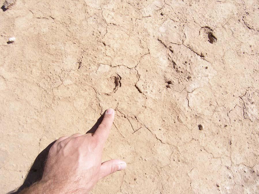
 Barnes conglomerate displaying channel features. Yellow lines mark the main bedding planes. Scale bar = 2 m. C) Matrix-supported Barnes conglomerate.")
5 3. Supplementary figures Fig. S1. Examples DSQ outcrops. A-C = Horton Creek. A) Desiccation cracks on sandstone-siltstone overlying the Barnes Conglomerate. B) Barnes conglomerate displaying channel features. Yellow lines mark the main bedding planes. Scale bar = 2 m. C) Matrix-supported Barnes conglomerate. Yellow lines delineate sandstoneconglomerate intercalations. Scale bar = 50 cm. D-F = Parker Canyon. D) Portion of the DSQ Middle member displaying tabular geometry of the strata due to rhythmic deposition. Scale bar = 2 m. E) Upper section of the Middle member showing shallow channels (yellow lines) underlying thin bedded strata. Scale bar = 50 cm. F) Lower portion of the Middle member showing wedged strata and cross stratification (yellow lines). Rhythmic deposition is well marked by differential rock coloration. Scale bar = 2 m. G) Upper Member at Coolidge Dam. Outcrop of red-purplish, finely laminated mudstonesiltstone. Scale bar = 50 cm. H) Typical bedding surface at Coolidge Dam covered with desiccation cracks (gray areas are modern graffiti).
 General view of the coarse alluvial sediments at the proximal source area (indicated as 1 in A), looking toward the range.")
6 Fig. S2. Modern Sonoran desert study site. A) Map with the location of the Mohawk Range, near Yuma, AZ, and the San Joaquin flood plain ( , ). Scale = 5 Km. B) General view of the coarse alluvial sediments at the proximal source area (indicated as 1 in A), looking toward the range. C) Prograding sequence of non-lithified sand deposited on basement rocks, and covered by even thicker conglomeratic proximal facies (indicated as 2 in A). Scale = 1 m. D) Surface view of the less-coarse mid-alluvial facies (indicated as 3 in A). Scale = 50 cm. E) Surface view of the medial facies but closer to the distal side (indicated as 4 in A). Note the much less pebbly material and the pervasive development of earth cracks. Scale = 50 cm. F) Distal facies of the dry, muddy flood plain (indicated as 5 in A), looking toward the range. The pebblylooking ground is due to abundant roll-ups. Scale = 50 cm.
.")

7 Fig. S3. Gas vesicles and vesicular horizons. A) Wet sawn rock displaying empty fenestral gas vesicles. The rock was one of many others, from different geographic and stratigraphic locations, displaying empty voids (see inset). The rock was first embedded in resin to probe for its filtration and filling of voids that could be exposed to the atmosphere by fractures, and through which the void infillings could have escaped. Dozens of sawn samples demonstrate that no voids were ever infilled. No fractures are seen associated directly with the voids, but follow the natural layering of the original deposit. Scale bar = 2 cm. B) An example of a vesicular horizon (marked upper zone) under a thin microbial crust. Elongated, subhorizontal vesicles are seen in the bottom zone (marked) along with ped formation. C) Gas vesicles forming a vesicular horizon under cyanobacteria-infested desiccation polygons. Scale bar = 10 cm. D) Watersaturated sandy substrate, previously inoculated with cyanobacteria (Microcoleus vaginatus), which has formed a cohesive top layer. E) The cyanobacteria layer in picture D was removed to expose well rounded gas vesicles. F) Example of fossil gas vesicles showing a thin, layered deposit on top of them (arrow), and their contribution to the irregular topography at the surface. Scale = 2 cm. A B


8 C D E

9 F
10 Fig. S4. Gas domes and collapsed gas domes in arid soil surfaces. A) Several gas domes are shown on a desert top soil colonized by cyanobacteria after a flood. Conspicuous gas domes are bound by a thin exopolysaccharide film (black arrows). Some show the initial stages of collapse (flattened tops). Several collapsed domes (white arrows) appear as round pools. B) Delicate and thin bubbles had formed on a natural sample before collapsing (big arrows) and leaving an imprint. Bulges can also be observed (small arrow). C) Proterozoic sample showing thin siltstone layers forming a collapsed bubble-like feature (big arrow). Note bulges (small arrows) also associated to gas vesicles in the same rock sample (see Fig. S3). D) Proterozoic sample showing coarse, allochthonous grains on the bottom of a collapsed gas dome. E) This pair of collapsed gas domes (arrows) are slowly being filled with allochthonous, most notoriously coarser sediment. Scale bars = 1 cm.


11 A


12 B C

13 D E
14 Fig. S5.
Chapter 8: Learning objectives
 Chapter 8: Learning objectives Understand concept of sedimentary facies Signinifance of lateral and vertical facies associations Walther s Law Understand the sedimentary facies of alluvial fans, eolian
Sediment and sedimentary rocks Sediment
 Sediment and sedimentary rocks Sediment From sediments to sedimentary rocks (transportation, deposition, preservation and lithification) Types of sedimentary rocks (clastic, chemical and organic) Sedimentary
Paleo Lab #4 - Sedimentary Environments
 Paleo Lab #4 - Sedimentary Environments page - 1. CHARACTERISTICS OF SEDIMENT Grain size and grain shape: The sizes and shapes of sedimentary particles (grains) are modified considerably during their transportation
Sediment and Sedimentary rock
 Sediment and Sedimentary rock Sediment: An accumulation of loose mineral grains, such as boulders, pebbles, sand, silt or mud, which are not cemented together. Mechanical and chemical weathering produces
GY 402: Sedimentary Petrology
 UNIVERSITY OF SOUTH ALABAMA GY 402: Sedimentary Petrology Lecture 13: Immature Siliciclastic Sedimentary Environments Alluvial Fans, Braided Streams Instructor: Dr. Douglas W. Haywick Last Time Immature
Depositional Environments. Depositional Environments
 Depositional Environments Geographic area in which sediment is deposited Characterized by a combination of geological process & environmental conditions Depositional Environments Geological processes:
Data Repository item
 Data Repository (B25407): Localities and descriptions of measured sections of study areas Table 1. Localities of the measured sedimentary sections in the NW Sichuan Basin Section Number Stratigraphy Locality
Sedimentary and Stratigraphic Analysis of the Viking Sand in the Edgerton/Wainwright Area, Central Alberta* By Russell Walz 1
 Sedimentary and Stratigraphic Analysis of the Viking Sand in the Edgerton/Wainwright Area, Central Alberta* By Russell Walz 1 Search and Discovery Article #50030 (2006) Posted June 25, 2006 *Extended abstract
The San Benito Gravels: Fluvial Depositional Systems, Paleocurrents, and Provenance
 ES120 FIELD TRIP #2 10 April 2010 NAME: The San Benito Gravels: Fluvial Depositional Systems, Paleocurrents, and Provenance Introduction The San Benito Gravels (SBG) consists of a 500 m thick section of
Geo 302D: Age of Dinosaurs. LAB 2: Sedimentary rocks and processes
 Geo 302D: Age of Dinosaurs LAB 2: Sedimentary rocks and processes Last week we covered the basic types of rocks and the rock cycle. This lab concentrates on sedimentary rocks. Sedimentary rocks have special
ESC102. Sedimentary Rocks. Our keys to the past. Monday, February 11, 13
 ESC102 Sedimentary Rocks Our keys to the past Sedimentary Rocks Sedimentary rocks are rocks that form through the accumulation of sediment and the process of lithification. Lithification occurs after deposition
Lab 7: Sedimentary Structures
 Name: Lab 7: Sedimentary Structures Sedimentary rocks account for a negligibly small fraction of Earth s mass, yet they are commonly encountered because the processes that form them are ubiquitous in the
The Nature of Sedimentary Rocks
 The Nature of Sedimentary Rocks Sedimentary rocks are composed of: Fragments of other rocks Chemical precipitates Organic matter or biochemically produced materials The Nature of Sedimentary Rocks Sedimentary
Sediment. Weathering: mechanical and chemical decomposition and disintegration of rock and minerals at the surface
 Sediment Some basic terminology Weathering: mechanical and chemical decomposition and disintegration of rock and minerals at the surface Erosion: removal of weathered rock and minerals from one place to
GY 111: Physical Geology
 UNIVERSITY OF SOUTH ALABAMA GY 111: Physical Geology Lecture 14: Sedimentary Rocks Part 2: Alluvial Fans and Rivers Instructor: Dr. Douglas W. Haywick Last Time 1) Types of Sediment 2) Sedimentary Rock
Chapter 5. The Sedimentary Archives
 Chapter 5 The Sedimentary Archives Factors affecting Sedimentary Characteristics 1. Tectonic setting 2. Physical, chemical, and biological processes in the depositional environment 3. Method of sediment
Facies Analysis Of The Reservoir Rocks In The. Sylhet Trough, Bangladesh. Abstract
 Facies Analysis Of The Reservoir Rocks In The Sylhet Trough, Bangladesh Joyanta Dutta Petroleum Geoscience Program, Department of Geology, Faculty of Science, Chulalongkorn University, Bangkok 10330, Thailand
ES120 Sedimentology/Stratigraphy
 Midterm Exam 5/05/08 NAME: 1. List or describe 3 physical processes that contribute to the weathering of rocks (3pts). exfoliation frost wedging many others. roots, thermal expansion/contraction also credit
EARTH SURFACE PROCESSES AND SEDIMENTATION!
 Sed and Strat EARTH SURFACE PROCESSES AND SEDIMENTATION! 2/27 Lecture 7- Exposure: Weathering and the Sediment Factory 3/04 Lecture 8 - Rivers and Landscapes 3/06 Lecture 9 - Waves (not Tides) 3/11 Lecture
SUPPLEMENTAL MATERIAL
 SUPPLEMENTAL MATERIAL DESCRIPTIONS OF OTHER STRATIGRAPHIC SECTIONS Cherry Creek In its middle reaches, Cherry Creek meanders between three paired terraces within a narrow bedrock valley. The highest is
Sand. Sand is any eroded material (igneous, metamorphic or sedimentary) that has a grain size from 1/16 th to 2 millimeters in size.
 that has a grain size from 1/16 th to 2 millimeters in size.") Sedimentology 001 What is sedimentology? Sedimentology...encompasses the study of modern sediments such as sand [1], mud (silt) [2] andclay [3] and understanding the processes that deposit them.[4] It
Sedimentology 001 What is sedimentology? Sedimentology...encompasses the study of modern sediments such as sand [1], mud (silt) [2] andclay [3] and understanding the processes that deposit them.[4] It
Lecture Outline Wednesday - Friday February 14-16, 2018
 Lecture Outline Wednesday - Friday February 14-16, 2018 Quiz 2 scheduled for Friday Feb 23 (Interlude B, Chapters 6,7) Questions? Chapter 6 Pages of the Past: Sedimentary Rocks Key Points for today Be
High-resolution Sequence Stratigraphy of the Glauconitic Sandstone, Upper Mannville C Pool, Cessford Field: a Record of Evolving Accommodation
 Page No. 069-1 High-resolution Sequence Stratigraphy of the Glauconitic Sandstone, Upper Mannville C Pool, Cessford Field: a Record of Evolving Accommodation Thérèse Lynch* and John Hopkins, Department
Section I: Multiple Choice Select the best answer to each question. Mark your final answer on the answer sheet. (1 pt each)
") Sedimentary Rocks & Surface Processes Quest Name: Earth Science 2013 Block: Date: Section I: Multiple Choice Select the best answer to each question. Mark your final answer on the answer sheet. (1 pt each)
Sedimentary Rocks & Surface Processes Quest Name: Earth Science 2013 Block: Date: Section I: Multiple Choice Select the best answer to each question. Mark your final answer on the answer sheet. (1 pt each)
Facies Cryptic description Depositional processes Depositional environments Very well sorted. Desert dunes. Migration of straight crested mega ripples
 Very well sorted Travelled grate distance, effective sorting 5 medium-grained sandstone with well rounded grains; large scale high angle planar cross-beds. Migration of straight crested mega ripples Desert
GEOLOGY MEDIA SUITE Chapter 8
 UNDERSTANDING EARTH, SIXTH EDITION GROTZINGER JORDAN GEOLOGY MEDIA SUITE Chapter 8 Clocks in Rocks Timing the Geologic Record 2010 W.H. Freeman and Company Stratigraphy and fossils Figure 8.4 (page 172)
Daniel Koning, Peggy Johnson, and John Hawley. New Mexico Bureau of Geology and Mineral Resources
 Daniel Koning, Peggy Johnson, and John Hawley Daniel Koning 1, Gary Smith 2, and Adam Read 1 1 New Mexico Bureau of Geology and Mineral Resources 2 University of New Mexico Santa Fe Group Definition (Spiegel
Igneous and Metamorphic Rock Forming Minerals. Department of Geology Mr. Victor Tibane SGM 210_2013
 Igneous and Metamorphic Rock Forming Minerals Department of Geology Mr. Victor Tibane 1 SGM 210_2013 Classification of sedimentary rocks Sedimentary rocks are products of weathered, fragmented or dissolved,
Bulletin of Earth Sciences of Thailand
 Depositional Environments and Stratigraphic Development of the Grand Taman Sari Circuit Outcrop: an Analogue for Transgressive Mahakam Delta Successions Ridha Santika Riadi Petroleum Geoscience Program,
GEOLOGY MEDIA SUITE Chapter 5
 UNDERSTANDING EARTH, SIXTH EDITION GROTZINGER JORDAN GEOLOGY MEDIA SUITE Chapter 5 Sedimentation Rocks Formed by Surface Processes 2010 W.H. Freeman and Company Mineralogy of sandstones Key Figure 5.12
Geology Stratigraphic Correlations (Lab #4, Winter 2010)
") Name: Answers Reg. lab day: Tu W Th Geology 1023 Stratigraphic Correlations (Lab #4, Winter 2010) Introduction Stratigraphic correlation is the process of comparing rocks at one locality with related rocks
Name: Answers Reg. lab day: Tu W Th Geology 1023 Stratigraphic Correlations (Lab #4, Winter 2010) Introduction Stratigraphic correlation is the process of comparing rocks at one locality with related rocks
Coso Red Hill and Coso Playa field trip, Prof. Alessandro Grippo, Ph.D.
 HISTORICAL GEOLOGY fall 2016 Professor: Dr. Alessandro Grippo, Ph.D. FIELD TRIP REPORT: Friday, October 21, 2016: Coso Red Hill & Playa, Coso Junction CA YOUR NAME part 1: COSO RED HILL (you can sample
sedimentary cover a) marine sediments b) continental sediments depth of crust: 5-10 km
 marine sediments b) continental sediments depth of crust: 5-10 km") Deformation and Brittle Fracture I. Primary Rock Structure A. Tectonic Control of Rock Structure 1. Lithospheric Plates a. plate = crust + upper mantle above asthenosphere (1) Layered Crust (a) oceanic
Deformation and Brittle Fracture I. Primary Rock Structure A. Tectonic Control of Rock Structure 1. Lithospheric Plates a. plate = crust + upper mantle above asthenosphere (1) Layered Crust (a) oceanic
Objectives: Define Relative Age, Absolute Age
 S6E5. Students will investigate the scientific view of how the earth s surface is formed. c. Classify rocks by their process of formation. g. Describe how fossils show evidence of the changing surface
Summary. Introduction. Observations and Interpretations
 Lower McMurray Formation sinkholes and their fill fabrics: effects of salt dissolution collapse-subsidence across the northern Athabasca oil sands deposit Paul L. Broughton, Chevron Canada Resources, Calgary,
=%REPORT RECONNAISSANCE OF CHISHOLM LAKE PROSPECT. October 25, 1977
 =%REPORT ON FIELD RECONNAISSANCE OF CHISHOLM LAKE PROSPECT October 25, 1977 Bruce D. Vincent Imperial Oil Limited, Minerals - Coal, CALGARY, ALBERTA CHISHOLM LAKE PROSPECT Introduction The Chisholm Lake
The Hydrologic Cycle
 CONTINENTAL DEPOSITIONAL ENVIRONMENTS fluvial desert lacustrine (lake) Glacial KEY PARAMETERS (VARIABLES) 1. Climate (Hydrologic Cycle) Annual Precip vs. Seasonality 2. Tectonics (Mountains) The Hydrologic
Sup. Mat. 1. Figure DR1. Map showing the distribution of the Vanrhynsdorp Group. 02
 GSA DATA REPOSITORY 2013142 Buatois, Almond and Germs Treptichnus pedum - List of supplementary materials: Sup. Mat. 1. Figure DR1. Map showing the distribution of the Vanrhynsdorp Group. 02 Sup. Mat.
GEL 109 Midterm W05, Page points total (1 point per minute is a good pace, but it is good to have time to recheck your answers!
 GEL 109 Midterm W05, Page 1 50 points total (1 point per minute is a good pace, but it is good to have time to recheck your answers!) 1. Are the following flow types typically laminar or turbulent and
Depositional Environment
 Depositional Environment Sedimentary depositional environment describes the combination of physical, chemical and biological processes associated with the deposition of a particular type of sediment. Types
Primary Structures in Sedimentary Rocks. Engr. Sultan A. Khoso
 Primary Structures in Sedimentary Rocks Engr. Sultan A. Khoso Sedimentary rocks Sedimentary rocks are those rocks which are formed by the weathered sediments of pre existing rocks (igneous or metamorphic
Chapter 5 Sedimentary Environments
 Chapter 3 Notes 1 Chapter 5 Sedimentary Environments A. The Tectonic Setting 1.Factors that determine the kind of sedimentary rock that will be formed in a particular area: a. the climate under which processes
Principles of Geology
 Principles of Geology Essential Questions What is Uniformitarianism? What is Catastrophism? What is Steno s s Law? What are the other geologic principles? How is relative age determined using these principles?
GEL 109 Midterm W01, Page points total (1 point per minute is a good pace, but it is good to have time to recheck your answers!
 GEL 109 Midterm W01, Page 1 50 points total (1 point per minute is a good pace, but it is good to have time to recheck your answers!) 1. Where in a water flow is there usually a zone of laminar flow even
 UNIT DESCRIPTIONS: Artificial Fill, Undocumented (Afu): Locally derived sandy silt and silty sand, locally with clay and varying amounts of gravel and man-made debris. Abundant concrete rubble, in places
Journal of Sedimentary Environments Published by Universidade do Estado do Rio de Janeiro SM2: doi: /jse SUPPLEMENTARY MATERIAL
 Appendix 2 Citation: Bergamaschi, S., Duarte, A.C.F., Serrano, J.S., Figueiredo, A.M.B., Vasconcelos, L.C., Oliveira, R.M.A.G., Ade, M.V.B., Pinheiro, A.E.P.P., Martins, M.V.A., 2016. Regional outcrops
Outcrops from Every Continent and 20 Countries in 140 Contributions. Tor H. Nilsen, Roger D. Shew, Gary S. Steffens, and Joseph R.J. Studlick.
 Paper VIII Tor H. Nilsen, Roger D. Shew, Gary S. Steffens, and Joseph R.J. Studlick Editors Outcrops from Every Continent and 20 Countries in 140 Contributions http://bookstore.aapg.org Length ~ 23 m (75.5
Sedimentary Rocks. Origin, Properties and Identification. Geology Laboratory GEOL 101 Lab Ray Rector - Instructor
 Sedimentary Rocks Origin, Properties and Identification Geology Laboratory GEOL 101 Lab Ray Rector - Instructor Sedimentary Rock Origin and Identification Lab Pre-Lab Internet Link Resources 1) http://www.rockhounds.com/rockshop/rockkey/index.html
Sedimentary Rocks. Origin, Properties and Identification. Physical Geology GEOL 101 Lab Ray Rector - Instructor
 Sedimentary Rocks Origin, Properties and Identification Physical Geology GEOL 101 Lab Ray Rector - Instructor Sedimentary Rock Origin and Identification Lab Pre-Lab Internet Link Resources 1) http://www.rockhounds.com/rockshop/rockkey/index.html
Geology (Mellow) Hike, Santa Lucia Memorial Park February 16, I. Overview of Santa Lucia Range geology and tectonic history
 Hike, Santa Lucia Memorial Park February 16, I. Overview of Santa Lucia Range geology and tectonic history") Geology (Mellow) Hike, Santa Lucia Memorial Park February 16, 2015 I. Overview of Santa Lucia Range geology and tectonic history A. Basement Rocks 1. Salinian Block Rocks Sierra Nevada Type, continental
Geology (Mellow) Hike, Santa Lucia Memorial Park February 16, 2015 I. Overview of Santa Lucia Range geology and tectonic history A. Basement Rocks 1. Salinian Block Rocks Sierra Nevada Type, continental
When last we left off. Western Cordillera NA. Cretaceous. Cretaceous, continued. Cretaceous to present
 When last we left off Western Cordillera NA Cretaceous to present Wild and weird things happened in the murky past of the Archean and precambrian Cambrian through Devonian development of deep water sediments
State the principle of uniformitarianism. Explain how the law of superposition can be used to determine the relative age of rocks.
 Objectives State the principle of uniformitarianism. Explain how the law of superposition can be used to determine the relative age of rocks. Compare three types of unconformities. Apply the law of crosscutting
Sediments and Sedimentary Rocks
 Sediments and Sedimentary Rocks (Shaping Earth s Surface, Part 2) Science 330 Summer 2005 What is a sedimentary rock? Products of mechanical and chemical weathering Account for about 5 percent of Earth
Sedimentary System Characteristics of Deng-3 Section on Paleo-central. Uplift Belt in Northern Songliao Basin. Siyang Li1,a*
 Sedimentary System Characteristics of Deng-3 Section on Paleo-central Uplift Belt in Northern Songliao Basin Siyang Li1,a* 1 School of Earth Sciences and Resources, China University of Geosciences, Beijing,
Sedimentary Structures in Metamorphic Rocks
 Maine Geologic Facts and Localities November, 2006 Primary Sedimentary Structures in Some Metamorphic Rocks Text by Thomas K. Weddle, Department of Agriculture, Conservation & Forestry 1 Photo by Thomas
Lecture 19: Fluvial Facies
 GEOL 440 Sedimentology and stratigraphy: processes, environments and deposits Lecture 19: Fluvial Facies Aims Examine controls on alluvial channel pattern List the types of channel pattern Examine meandering
The unknown giants - low-permeability shallow gas reservoirs of southern Alberta and Saskatchewan, Canada.
 The unknown giants - low-permeability shallow gas reservoirs of southern Alberta and Saskatchewan, Canada. Shaun O'Connell* Belfield Resources Inc., Calgary belfield@shaw.ca ABSTRACT The gas reserves contained
Maine Geologic Facts and Localities October, Lobster Lake, Maine. Text by Robert G. Marvinney. Maine Geological Survey
 Maine Geologic Facts and Localities October, 1998 Lobster Lake, Maine 45 o 51 7.91 N, 69 o 30 53.88 W Text by Robert G. Marvinney, Department of Agriculture, Conservation & Forestry 1 Map by Introduction
NC Earth Science Essential Standards
 NC Earth Science Essential Standards EEn. 2.1 Explain how processes and forces affect the Lithosphere. EEn. 2.1.1 Explain how the rock cycle, plate tectonics, volcanoes, and earthquakes impact the Lithosphere.
As compaction and cementation of these sediments eventually occur, which area will become siltstone? A) A B) B C) C D) D
 A B) B C) C D) D") 1. A student obtains a cup of quartz sand from a beach. A saltwater solution is poured into the sand and allowed to evaporate. The mineral residue from the saltwater solution cements the sand grains together,
1. A student obtains a cup of quartz sand from a beach. A saltwater solution is poured into the sand and allowed to evaporate. The mineral residue from the saltwater solution cements the sand grains together,
Clastic Sedimentary Rocks
 Clastic Sedimentary Rocks Alessandro Grippo, Ph.D. Alternating sandstones and mudstones in Miocene turbidites Camaggiore di Firenzuola, Firenze, Italy Alessandro Grippo review Mechanical weathering creates
Fluid-Mud Deposits of the Lower Jurassic Tilje Formation, Offshore Mid-Norway By Aitor A. Ichaso and Robert W. Dalrymple 1
 Fluid-Mud Deposits of the Lower Jurassic Tilje Formation, Offshore Mid-Norway By Aitor A. Ichaso and Robert W. Dalrymple 1 Search and Discovery Article #50107 (2008) Posted August 10, 2008 *Adapted from
Integrating 3-D Facies Analysis of Glacial Aquifer Systems with Groundwater Flow Models: Examples from New England and the Great Lakes Region, USA
 Integrating 3-D Facies Analysis of Glacial Aquifer Systems with Groundwater Flow Models: Examples from New England and the Great Lakes Region, USA Stone, B.D., J.R. Stone, J.P. Masterson, and D.W. O'Leary
Chapter 6 Pages of Earth s Past: Sedimentary Rocks
 Chapter 6 Pages of Earth s Past: Sedimentary Rocks Introduction! Drilling into the bottom of the North Sea, we encounter: " Soft mud and loose sand, silt, pebbles, and shells. Then: " Similar materials
Geo 302D: Age of Dinosaurs. LAB 1: Introduction to Rocks and Sedimentary Processes
 Geo 302D: Age of Dinosaurs LAB 1: Introduction to Rocks and Sedimentary Processes We would not be able to address the interesting questions of dinosaurs and their place in the history of life without the
SUPPLEMENTAL INFORMATION DELFT 3-D MODELING: MODEL DESIGN, SETUP, AND ANALYSIS
 GSA DATA REPOSITORY 2014069 Hajek and Edmonds SUPPLEMENTAL INFORMATION DELFT 3-D MODELING: MODEL DESIGN, SETUP, AND ANALYSIS Each experiment starts from the initial condition of a straight channel 10 km
GY 402: Sedimentary Petrology
 UNIVERSITY OF SOUTH ALABAMA GY 402: Sedimentary Petrology Lecture 17: Sandy Fluvial Depositional Environments Instructor: Dr. Douglas W. Haywick Last Time Volcaniclastic Sedimentary Rocks 1. Origin of
Sedimentary Rocks. Origin, Properties and Identification. Physical Geology GEOL 100. Ray Rector - Instructor
 Sedimentary Rocks Origin, Properties and Identification Physical Geology GEOL 100 Ray Rector - Instructor Sedimentary Rock Origin and Identification Lab Pre-Lab Internet Link Resources 1) http://www.rockhounds.com/rockshop/rockkey/index.html
Earth Materials Unit: Sedimen ntary Rocks and Processes Maybe One Day Text: Chapters Five and Six Lab: Laboratorry Six Name
 Earth Materi ials Unit: Sedimentary Rocks and Proces sses Maybe One Day Text: Chapters Fivee and Six Lab: Laboratory Six Name Page 1 Sedimentary Rocks and Processes Purpose: To classify sedimentary rocks
NAME: GEL 109 Final Study Guide - Winter 2008 Questions 6-24 WILL be on the final exactly as written here; this is 60% of the test.
 GEL 109 Final Study Guide - Winter 2008 Questions 6-24 WILL be on the final exactly as written here; this is 60% of the test. 1. Sketch a map view of three types of deltas showing the differences in river,
Viking Lowstand Deposits in West Central Saskatchewan: Depositional Model for the Reservoir Units in Dodsland-Hoosier Area, Saskatchewan, Canada
 Viking Lowstand Deposits in West Central Saskatchewan: Depositional Model for the Reservoir Units in Dodsland-Hoosier Area, Saskatchewan, Canada Hasan Ferdous* PetroSed Geoconsulting Resources, Calgary,
The boundary between two formations (or any distinct layers) is called a contact. Sedimentary rocks cover 75% of continents.
 is called a contact. Sedimentary rocks cover 75% of continents.") Sedimentary Rocks Sedimentary rocks form at the Earth s surface through interactions of the hydrologic system and the crust. Fortunately, many of these processes are in operation today, and geologists
Sedimentary Rocks Sedimentary rocks form at the Earth s surface through interactions of the hydrologic system and the crust. Fortunately, many of these processes are in operation today, and geologists
EPS 50 Lab 4: Sedimentary Rocks
 Name: EPS 50 Lab 4: Sedimentary Rocks Grotzinger and Jordan, Chapter 5 Introduction In this lab we will classify sedimentary rocks and investigate the relationship between environmental conditions and
Exploration Significance of Unconformity Structure on Subtle Pools. 1 Vertical structure characteristics of unconformity
 Exploration Significance of Unconformity Structure on Subtle Pools Wu Kongyou (China University of Petroleum,College of Geo-Resources and Information,Shandong Qingdao 266555) Abstract: Vertical structure
SOUTH CERRO AZUL STRATIGRAPHIC SECTION. Upper Cerro Azul flow of the Servilleta Basalt (Tsbcau) Lower Sandlin unit (Tsl)
 Lower Sandlin unit (Tsl)") Figure A3-01 cobbles claysilt general grain size sand pebbles vf f m c vc SOUTH CERRO AZUL STRATIGRAPHIC SECTION Top at 18 m. Upper Cerro Azul flow of the Servilleta Basalt (Tsbcau) 15 Basalt: Very dark
Figure A3-01 cobbles claysilt general grain size sand pebbles vf f m c vc SOUTH CERRO AZUL STRATIGRAPHIC SECTION Top at 18 m. Upper Cerro Azul flow of the Servilleta Basalt (Tsbcau) 15 Basalt: Very dark
Continental Environments. Continental Environments. Chapter 9. Deserts Alluvial fans Rivers (fluvial) and floodplains Lakes (lacustrine) Glacial
 and floodplains Lakes (lacustrine) Glacial") Continental Environments Chapter 9 Continental Environments Deserts Alluvial fans Rivers (fluvial) and floodplains Lakes (lacustrine) Glacial Desert Biome http://www.blueplanetbiomes.org/climate.htm low-latitude
Continental Environments Chapter 9 Continental Environments Deserts Alluvial fans Rivers (fluvial) and floodplains Lakes (lacustrine) Glacial Desert Biome http://www.blueplanetbiomes.org/climate.htm low-latitude
UNIT 4 SEDIMENTARY ROCKS
 UNIT 4 SEDIMENTARY ROCKS WHAT ARE SEDIMENTS Sediments are loose Earth materials (unconsolidated materials) such as sand which are transported by the action of water, wind, glacial ice and gravity. These
Accommodation. Tectonics (local to regional) Subsidence Uplift
 Subsidence Uplift") Accommodation Accommodation varies over time; it is the distance between a reference horizon and the sea surface (i.e. relative sea level). The space to be filled in with sediments or water What are the
Accommodation Accommodation varies over time; it is the distance between a reference horizon and the sea surface (i.e. relative sea level). The space to be filled in with sediments or water What are the
1/31/2013. Weathering Includes Physical, Chemical, Biological processes. Weathering Mechanisms. Wind abrasion forming Ventifacts
 Monument Valley, Utah. What weathering processes contributed to the development of these remarkable rock formations? Weathering Includes Physical, Chemical, Biological processes Weathering Mechanisms Physical
Glauconitic Oil Reservoirs in Southern Alberta Creating the Correct Geological Model to Guide Development Drilling
 Glauconitic Oil Reservoirs in Southern Alberta Creating the Correct Geological Model to Guide Development Drilling Brad Hayes* Petrel Robertson Consulting Ltd, Calgary, AB bhayes@petrelrob.com Lisa Griffith
AAPG Search and Discovery Article #90173 CSPG/CSEG/CWLS GeoConvention 2011, Calgary, Alberta, Canada, May 9-11, 2011
 Use of Image Logs in Differentiating Point Bar and Tidal Bar Deposits in the Leismer Area: Implications for SAGD Reservoir Definition in the Athabasca Oilsands Howard Brekke and Andrew Couch Introduction
Facies Analysis of the Lower Cretaceous Wilrich Member (Lower Falher) of the Spirit River Formation.
 of the Spirit River Formation.") Facies Analysis of the Lower Cretaceous Wilrich Member (Lower Falher) of the Spirit River Formation. Kerrie L. Bann, Ichnofacies Analysis Inc. and Daniel J. K. Ross, Tourmaline Oil Corp. Historically,
Facies Analysis of the Lower Cretaceous Wilrich Member (Lower Falher) of the Spirit River Formation. Kerrie L. Bann, Ichnofacies Analysis Inc. and Daniel J. K. Ross, Tourmaline Oil Corp. Historically,
Instructor s Manual Chapter 3
 CHAPTER 3 Resource Integration Guide Chapter Outline Chapter Summary Lecture Suggestions Key Terms Web Links Virtual Field Trip Suggested Responses Chapter Outline 3.1 and the Rock Cycle 3.1a The Rock
Geological Mapping of Sedimentary Rocks
 Geological Mapping 1 Ac. year 2016/2017 Geological Mapping of Sedimentary Rocks Igor Vlahović igor.vlahovic@rgn.hr 1. kolokvij iz GK1: kolokvij ponedjeljak 10. travnja u 14:15 h (GP predavaonica). ispravak
GEOLOGY. Subject : GEOLOGY (For under graduate student.) Paper No. : Paper 02 Introduction to Geology 02
 Paper No. : Paper 02 Introduction to Geology 02") GEOLOGY Subject : GEOLOGY (For under graduate student.) Paper No. : Paper 02 Introduction to Geology 02 Topic No. & Title : 56 Structure of Sedimentary Rocks Frequently Asked Questions FAQ s Que 01. What
GEOLOGY Subject : GEOLOGY (For under graduate student.) Paper No. : Paper 02 Introduction to Geology 02 Topic No. & Title : 56 Structure of Sedimentary Rocks Frequently Asked Questions FAQ s Que 01. What
Writing Earth s History
 Earths History Writing Earth s History How is Earths History like writing in your Journal? Everyday, something happens and, with a pen, it is written down in the pages of your journal. As you continue,
NAME: GEL 109 Final Winter 2010
 GEL 109 Final Winter 2010 1. The following stratigraphic sections represents a single event followed by the slow accumulation of background sedimentation of shale. Describe the flows that produced the
GY 111 Lecture Note Series Sedimentary Environments 2: Rivers and Deltas
 GY 111 Lecture Notes D. Haywick (2008-09) 1 GY 111 Lecture Note Series Sedimentary Environments 2: Rivers and Deltas Lecture Goals A) Rivers and Deltas (types) B) Water Flow and sedimentation in river/deltas
Understanding Earth Fifth Edition
 Understanding Earth Fifth Edition Grotzinger Jordan Press Siever Chapter 5: SEDIMENTATION: Rocks Formed by Surface Processes Lecturer: H Mohammadzadeh Assistant professors, Department of Geology, FUM Copyright
Page 1. Weathering & Erosion by Mass Wasting Pre-Test. Name:
 Weathering & Erosion by Mass Wasting Pre-Test 3048-1 - Page 1 Name: 1) As a particle of sediment in a stream breaks into several smaller pieces, the rate of weathering of the sediment will A) increase
What is weathering and how does it change Earth s surface? Answer the question using
 7 th Grade Lesson What is weathering and how does it change Earth s surface? Answer the question using the sentence frame. You have 4 minutes. Weathering is. This changes the Earth s surface because. 1
Sediments and. Sedimentary Rocks
 Sediments and Sedimentary Rocks Bottom Line Sedimentary rocks form from particles accumulated in sedimentary layers Sedimentary layers can be formed by clastic or detrital particles (e.g., sand grains,
402: Sedimentary Petrology
 UNIVERSITY OF SOUTH ALABAMA 402: Sedimentary Petrology Lecture 14: Siliciclastic Diagenesis Instructor: Dr. Douglas W. Haywick Last Time (online) Immature siliciclastic sediment and sedimentary rocks Pictorial
11/22/2010. Groundwater in Unconsolidated Deposits. Alluvial (fluvial) deposits. - consist of gravel, sand, silt and clay
 deposits. - consist of gravel, sand, silt and clay") Groundwater in Unconsolidated Deposits Alluvial (fluvial) deposits - consist of gravel, sand, silt and clay - laid down by physical processes in rivers and flood plains - major sources for water supplies
Groundwater in Unconsolidated Deposits Alluvial (fluvial) deposits - consist of gravel, sand, silt and clay - laid down by physical processes in rivers and flood plains - major sources for water supplies
Chapter 7: Sediment and Sedimentary Rocks
 Chapter 7: Sediment and Sedimentary Rocks Chapter Outline 7.1 Introduction 7.2 Sediment Sources, Transport, and Deposition 7.3 How Does Sediment Become Sedimentary Rock? 7.4 Types of Sedimentary Rocks
Structural Geology Lab. The Objectives are to gain experience
 Geology 2 Structural Geology Lab The Objectives are to gain experience 1. Drawing cross sections from information given on geologic maps. 2. Recognizing folds and naming their parts on stereoscopic air
Sedimentary Environments Chapter 8
 Sedimentary Environments Chapter 8 Does not contain complete lecture notes. To be used to help organize lecture notes and home/test studies. What is a sedimentary rock? Sedimentary rocks are products of
The McCully gas field in southern New Brunswick was discovered in the year 2000 on a joint drilling exploration venture by Corridor Resources Inc.
 1 The McCully gas field in southern New Brunswick was discovered in the year 2000 on a joint drilling exploration venture by Corridor Resources Inc. and Potash Corporation of Saskatchewan. Located about
GeoCanada 2010 Working with the Earth
 Lithofacies Identification and the Implications for SAGD Well Planning in the McMurray Formation, Christina Lake Area, Alberta Travis Shackleton*, Robert Gardner, Sung Youn, Grace Eng and Lori Barth Cenovus
Ecoregions Glossary. 7.8B: Changes To Texas Land Earth and Space
 Ecoregions Glossary Ecoregions The term ecoregions was developed by combining the terms ecology and region. Ecology is the study of the interrelationship of organisms and their environments. The term,