Benefits of Spatial Collaboration in Arctic Research Project Using ArcGIS Online
|
|
|
- Anna Underwood
- 5 years ago
- Views:
Transcription

1 Benefits of Spatial Collaboration in Arctic Research Project Using ArcGIS Online Dr. Nataliya Marchenko Prof. Aleksey Marchenko The University Centre in Svalbard, Longyearbyen, Norway Arctic Technology Department N. & A. Marchenko_ESRI UC
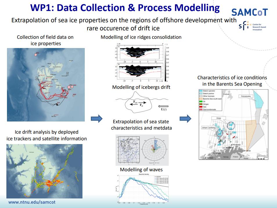
2 Outline l Introduction - Motivation Sustainable Arctic Marine and Coastal Technology (SAMCoT) Data collection and storage SAMCoT GIS online Conclusion 2
 The")


3 The University Centre in Svalbard (UNIS) The northernmost university UNIS Gate to the Polar Ocean Area with increased strategic significance Well suited to observe climate change Research field-based education Use nature as laboratory Investigation of Sea Ice properties. Full scale experiments 3
.")
4 Sustainable Arctic Marine and Coastal Technology (SAMCoT) - part of the Norwegian CRI programm In June 2006, the Executive Board of the Research Council of Norway (RCN) decided to establish Centres for Research-based Innovation (CRIs). The main objective - to enhance the capability of the business sector to innovate by focusing on long-term research based on forging close alliances between research-intensive enterprises and prominent research groups. 4

5 ARCTIC FEATURES Huge Resources Remoteness Darkness in winter Mostly deep waters Possible presence of sea ice/icebergs. Main drivers: Oil and gas Mining Shipping Contributing industries: Fisheries Aquaculture Tourism Scientific research Arctic drivers 5

6 Threats for Offshore development 6
 7")
7 Sustainable Arctic Marine and Coastal Technology (SAMCoT) 7

8 SAMCoT strategy Quantifying the Physical Environment 8
9 9


; - Can be")

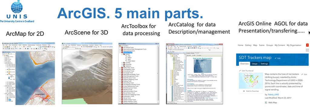
10 - Shows SAMCoT key sites and area properties, using ArcGIS software; - Has 5 hierarchic and scale levels for different territory size and details; - Contains diverse types of geographicaly located information (field and archive data, photos and video); - Can be used for modelling, Fram Strait Svalbard Barents Sea ArcMap for 2D ArcScene for 3D Baydara 10
11 11


 Reports -2002-2018 - Ice Mechanics, Hydrology,")
 - profiles")
 2016-2")
 - Ice properties")
12 SAMCoT GIS. DATA Made Under development BASIC LAYERS Bathymetry Hypsometry Coastal line Coastal erosion Settlements Industrial objects RV surveys DATA (Lance, Bjørkhaug, Polarsyssel)??) Reports Ice Mechanics, Hydrology, Ice Ridges Tracks , 2018 Measurements CTD- raw data (CNV files) - profiles (jpeg) ICE TRACKERS (AT drifting buoys) buoy (temp) (wind) (wave) FIELD WORK «on sites» DATA - Sea currents (Svalbard fjords) - Ice properties (tests in Svea, lake, RV surveys) - ADCP (Vestpynten) P U B L I C A T I O N S 12


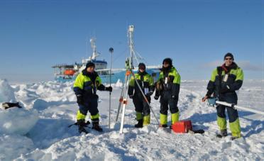
13 Data collection The Barents Sea Ice ridge investigation Measurement 13


14 Data analysis and performance. Ice ridge example 14


15 Laser scan 3D point cloud 15


16 Ice floe parameters Rhino's intrinsic functions provide a simple means of calculating the floe's geometric properties. 16


17 S m2 343 Vt m Vs m Sail 1,6 Draft 4, ,2 2,94 22,8x22, total 2655 submerged 3 Ice floes. Parameters (m) 2,16 3,82 N. & A. Marchenko_ESRI UC


18 We use the UNIS Arctic Technology New Work Station ( in the room A242A. We can reach this Work Station from all other UNIS computers, using Password (SAMCoT participants have access). So we are able run SAMCoT GIS and make demonstration from all UNIS auditoriums/ classrooms/ offices In March 2017 on-line version has been created? 18


19 SAMCoT GIS Online Oceanographical survey data 19


20 SAMCoT GIS Online. Survey reports and papers 20


21 SAMCoT GIS Online. Drifting buoys 21


22 GIS ONLINE connecting people 22

23 Acknowlegement RV teams (crew, UNIS students on AT-211 course, guest researchers) ESRI team SAMCoT project Colleagues at UNIS Thank you for your attention N. & A. Marchenko_ESRI UC
Safety of maritime operations and sustainable development of industrial areas in the Arctic. Aleksey Marchenko, UNIS
 Safety of maritime operations and sustainable development of industrial areas in the Arctic Aleksey Marchenko, UNIS 2012-2015 1 Synopsis 1. Development of educational and research cooperation between Norwegian
GEOGRAPHICAL INFORMATIONAL SYSTEMS FOR SUSTAINABLE ARCTIC TECHNOLOGY. Nataliya Marchenko 1,2,3*,
 POAC 13 Espoo, Finland Proceedings of the 22 nd International Conference on Port and Ocean Engineering under Arctic Conditions June 9-13, 2013 Espoo, Finland GEOGRAPHICAL INFORMATIONAL SYSTEMS FOR SUSTAINABLE
Ian Turnbull, Ryan Crawford, and Erik Veitch
 Ian Turnbull, Ryan Crawford, and Erik Veitch Ian Turnbull, PhD: Ice Researcher at C-CORE and Adjunct Professor, Department of Geography, Memorial University of Newfoundland (MUN), St. John s, Newfoundland
A self-portrait of the Northern Lights outside Nybyen and photos from our tour of the Kjell Henriksen Observatory and the EISCAT Svalbard Radar.
 Craig Martin Masters Student of Memorial University of Newfoundland, Canada; Department of Ocean and Naval Architectural Engineering. Bachelors Student of Arctic Technology at UNIS My Arctic Adventure
CANADIAN HYDROGRAPHIC SERVICE & OCEANOGRAPHIC SERVICES
 CANADIAN HYDROGRAPHIC SERVICE & OCEANOGRAPHIC SERVICES Presentation to Warming of the North Conference Ottawa, March 2 nd, 2015 Denis Hains, Director General & Hydrographer General of Canada TIP OF THE
MEASUREMENT OF LOADS EXERTED BY SEA ICE ON THE QUAY AT KAPP AMSTERDAM ON SVALBARD
 POAC 15 Trondheim, Norway Proceedings of the 23rd International Conference on Port and Ocean Engineering under Arctic Conditions June 14-18, 2015 Trondheim, Norway MEASUREMENT OF LOADS EXERTED BY SEA ICE
The future activity level in the High North and the risk patterns in different sea regions
 The 5 th MARPART workshop. MV Polarlys at the Hurtigruten The future activity level in the High North and the risk patterns in different sea regions Dr. Nataliya Marchenko The University Centre in Svalbard,
FINDINGS OF THE ARCTIC METEOROLOGY SUMMIT
 FINDINGS OF THE ARCTIC METEOROLOGY SUMMIT 2018 WWW.FMI.FI CHAIR S SUMMARY: 1 2 3 We need to be curious to explore the known unknowns. Meteorology is an elemental part of international collaboration in
A unique international environmental research and monitoring platform
 A unique international environmental research and monitoring platform Prof. Dr. Karin Lochte Alfred Wegener Institute for Polar an Marine Research in the Helmholtz Association Climate change in the Arctic
Research Programme Polar, Marine and Coastal Systems. Current and future Arctic research priorities of Germany Nicole Biebow, AWI
 Research Programme Polar, Marine and Coastal Systems Current and future Arctic research priorities of Germany Nicole Biebow, AWI Arctic Science and Technology (S&T) Collaboration and Engagement Workshop,
Understanding oceans in change: Engineering science and technological tools for distributed real-time sensing Kristin Guldbrandsen Frøysa, CMR and
 Understanding oceans in change: Engineering science and technological tools for distributed real-time sensing Kristin Guldbrandsen Frøysa, CMR and University of Bergen Anne A Hageberg, CMR Christian Michelsen
FINNISH INSTITUTE OF MARINE RESEARCH CRUISE REPORT. R/V Aranda. Cruise 2 / February - 22 April 2002
 FINNISH INSTITUTE OF MARINE RESEARCH CRUISE REPORT R/V Aranda Cruise 2 / 2002 11 February - 22 April 2002 The report is based on preliminary data and is subject to changes. Finnish Institute of Marine
Konstruksjonsdagen 2018 Ptil, 27 Aug Nordområdene. Prof. Sveinung Løset 1,2
 Konstruksjonsdagen 2018 Ptil, 27 Aug. 2018 Nordområdene Prof. Sveinung Løset 1,2 1) Sustainable Arctic Marine and Coastal Technology (SAMCoT), Centre for Research-based Innovation (CRI), Norwegian University
HY-2A Satellite User s Guide
 National Satellite Ocean Application Service 2013-5-16 Document Change Record Revision Date Changed Pages/Paragraphs Edit Description i Contents 1 Introduction to HY-2 Satellite... 1 2 HY-2 satellite data
The Arctic Crossroads
 The Arctic Crossroads The Influence of the Mendeleev Ridge and the Chukchi Borderland on the Large-scale Circulation of the Arctic Ocean Rebecca Woodgate and Knut Aagaard, University of Washington Jim
Marine Spatial Planning (MSP): A practical approach to ecosystembased
: A practical approach to ecosystembased") Marine Spatial Planning (MSP): A practical approach to ecosystembased management Erik Olsen, Institute of Marine Research, Norway Fanny Douvere, International Oceanographic Commission Overview Why we need
Marine Spatial Planning (MSP): A practical approach to ecosystembased management Erik Olsen, Institute of Marine Research, Norway Fanny Douvere, International Oceanographic Commission Overview Why we need
The known requirements for Arctic climate services
 The known requirements for Arctic climate services based on findings described in STT White paper 8/2015 Johanna Ekman / EC PHORS STT Regional drivers The Arctic region is home to almost four million people
German Arctic Expeditions
 German Arctic Expeditions 2015-2016 FARO/ASSW, 2016, Fairbanks Dirk Mengedoht (Alfred Wegener Institute, Germany) Dirk Mengedoht, AWI Logistics 2015 Polarstern Arctic Expeditions 2015 Leg Start End Mission
BOSNIA AND HERZEGOVINA
 Studies to support the development of sea basin cooperation in the Mediterranean, Adriatic and Ionian, and Black Sea CONTRACT NUMBER MARE/2012/07 - REF. NO 2 REPORT 1 - ANNEX 2.2 COUNTRY FICHE - ANNEX
E x a m p l e s o f t o o l s f o r s e a s i t u a t i o n a l a w a r e n e s s u s i n g C M E M S d a t a. Copernicus EU
 E x a m p l e s o f t o o l s f o r s e a s i t u a t i o n a l a w a r e n e s s u s i n g C M E M S d a t a Copernicus EU Copernicus EU Copernicus EU www.copernicus.eu S e a S i t u a t i o n a l A w
Warmer, wetter, wilder Arctic heritage
 Nordic Conference on Climate Change Adaptation Climate change in the Arctic: Warmer, wetter, wilder Arctic heritage Anne-Cathrine Flyen Anne-Cathrine Flyen Architect/Researcher Building preservation, climate
Norway leading the way in observing the new Arctic system
 Norway leading the way in observing the new Arctic system Gathering time series from the high Arctic The challenge of moving ice 1890s Fram 1990s SHEBA Upcoming large international ship-based drift Great
FINLAND, A COOL ARCTIC COUNTRY WITH SNOW-HOW
 FINLAND, A COOL ARCTIC COUNTRY WITH SNOW-HOW To succeed in a constantly changing world, you have to change as well. Finland has reinvented itself in just one short century and we re still at it. Our national
Pan-Arctic integration of research in the seasonal ice zone and the Nansen Legacy project. Paul Wassmann UiT The Arctic University of Norway
 Pan-Arctic integration of research in the seasonal ice zone and the Nansen Legacy project Paul Wassmann UiT The Arctic University of Norway It is ice-covered: The loss of Arctic sea ice has emerged as
Monitoring Sea Ice with Space-borne Synthetic Aperture Radar
 Monitoring Sea Ice with Space-borne Synthetic Aperture Radar Torbjørn Eltoft UiT- the Arctic University of Norway CIRFA A Centre for Research-based Innovation cirfa.uit.no Sea ice & climate Some basic
Cruise Report. RV Oceania, AREX2011. Institute of Oceanology Polish Academy of Sciences. the Norwegian, Greenland and Barents Seas
 w Warszawy 55, 81-712 Sopot, Poland, P.O. Box 68 10 December, 2011 Cruise Report RV Oceania, AREX2011 Institution Ship Name Cruise Name Institute of Oceanology Polish Academy of Sciences RV Oceania AREX2011
Arctic Observing Systems Challenges, New opportunities and Integration
 Arctic Observing Systems Challenges, New opportunities and Integration Japan Norway Arctic Science Week 03 June 2016 By Stein Sandven, NERSC Building an integrated Arctic Observing System Need to collect,
Marine Situational Awareness and Environmental Monitoring using Satellites
 1 The Ny-ålesund Symposium 2013 The Changing Arctic Opportunity or Threat Marine Situational Awareness and Environmental Monitoring using Satellites Rolf Skatteboe President, Kongsberg Satellite Services
Polar complications in the law of the sea: A case study of the regime for research and survey activities in the Arctic Ocean
 2010 ABLOS Conference: Contentious Issues in UNCLOS Surely Not? International Hydrographic Bureau, 25-27 October 2010 Polar complications in the law of the sea: A case study of the regime for research
Arctic Risk Map. Communicating Region s Complex Risk Picture. Øivin Aarnes Esri Petroleum GIS Conference. London, Nov. 6th DNV GL OIL & GAS
 DNV GL OIL & GAS Arctic Risk Map Communicating Region s Complex Risk Picture Øivin Aarnes Esri Petroleum GIS Conference. London, Nov. 6th. 2015 1 2015 9 November 2015 SAFER, SMARTER, GREENER DNV GL Global
Marine Spatial Planning Leslie-Ann McGee Battelle Memorial Institute
 Marine Spatial Planning Leslie-Ann McGee Battelle Memorial Institute Rev061708 1 Marine Spatial Planning What is it? Why is it different? Where is it currently being employed? What is happening in the
Marine Spatial Planning: A Tool for Implementing Ecosystem-Based Management
 Marine Spatial Planning: A Tool for Implementing Ecosystem-Based Management Steven Murawski, Ph.D., Ecosystem Goal Team Lead National Oceanic and Atmospheric Administration NOAA November 16, 2009 1 To
Land-fjord interaction and the impact of changing sedimentation rates on fjord environments
 Land-fjord interaction and the impact of changing sedimentation rates on fjord environments An integrated study of Arctic sediment transport from land to sea Maria Jensen (University Centre in Svalbard,
Cruise Report R/V Oceania, AREX 2007
 Powstańców Warszawy 55, PL - 81-712 Sopot, P.O. Box 68 March 15, 2008 Cruise Report R/V Oceania, AREX 2007 Ship: R/V Oceania Cruise: AREX 2007 Dates: 19.06.2007 05.08.2007 Port Calls: Gdansk (Poland) Longyearbyen
OPINION. Results of EU Structural Policy in NSPA
 OPINION on the future European Cohesion Policy of the Northern Sparsely Populated Areas (NSPA) of Finland and Sweden with the contribution of North Norway The remote Northern Sparsely Populated Areas (NSPA)
Applied Geoscience and Technology Division SOPAC. Joy Papao, Risk Information Systems Officer
 Joy Papao, Risk Information Systems Officer Secretariat of the Pacific Community SPC 22 Pacific Island States Head office in Noumea, New Caledonia 2 Regional offices (Pohnpei and Honiara) 600 staff 9 Technical
Arctic Science & Engineering. Martin Jeffries. Ron Liston Seminar, 17 October PhD. MSc. Calgary ( ) UK ( )
 UK ( )") Arctic Science & Calgary (1981-1985) Engineering PhD Martin Jeffries MSc Ron Liston Seminar, 17 October 2018. UK (1979-1981) Outline Career Background Research Background The State of the Arctic Arctic
Arctic Science & Calgary (1981-1985) Engineering PhD Martin Jeffries MSc Ron Liston Seminar, 17 October 2018. UK (1979-1981) Outline Career Background Research Background The State of the Arctic Arctic
FRontiers in Arctic marine Monitoring: The FRAM Ocean Observing System
 FRontiers in Arctic marine Monitoring: The FRAM Ocean Observing System Thomas Soltwedel Alfred-Wegener-Institute Helmholtz-Center for Polar and Marine Research Arctic Frontiers 2017 Svalbard Symposium
Spectral Albedos. a: dry snow. b: wet new snow. c: melting old snow. a: cold MY ice. b: melting MY ice. d: frozen pond. c: melting FY white ice
 Spectral Albedos a: dry snow b: wet new snow a: cold MY ice c: melting old snow b: melting MY ice d: frozen pond c: melting FY white ice d: melting FY blue ice e: early MY pond e: ageing ponds Extinction
Technologies for sea bottom inhabitants' monitoring and Integral Costal Zones Management. Example of the Kandalaksha Bay, White Sea
 Technologies for sea bottom inhabitants' monitoring and Integral Costal Zones Management. Example of the Kandalaksha Bay, White Sea Mikhail Tokarev, Roman Pevzner Transfer Technology Office of Lomonosov
Photo: Manbharat Singh Dhadly, Geophysical Institute, University of Alaska Fairbanks
 Photo: Manbharat Singh Dhadly, Geophysical Institute, University of Alaska Fairbanks Kings Bay strategy 2016 2018 "For the benefit of the world's climate and environmental knowledge" Global warming is
There and back again. An illustration of needs for cross-scale and cross-discipline collaboration and data sharing
 There and back again. An illustration of needs for cross-scale and cross-discipline collaboration and data sharing Late-summer distribution of freshwater (blue) around Svalbard, from model simulations.
Korean Arctic Research 2015 update
 FARO Annual Meeting, ASSW 2016 Fairbanks, Alaska, 12 March 2016 Korean Arctic Research 2015 update International Cooperation Department Korea Polar Research Institute Outline KOPRI and Korean Arctic research;
Arctic ecosystem services: TEEB Arctic Scoping study. Alexander Shestakov WWF Global Arctic Programme 3 December Arctic Biodiversity Congress
 Arctic ecosystem services: TEEB Arctic Scoping study Alexander Shestakov WWF Global Arctic Programme 3 December 20143 Arctic Biodiversity Congress Content 1. Project design 2. Approach 3. Challenges and
Marine Spatial Management Tool
 Marine Spatial Management Tool Marine Spatial Management Tool Support the marine spatial planning process with updated and reliable geospatial information Marine management is important to Norway with
CONFERENCE STATEMENT
 CONFERENCE STATEMENT We, the elected representatives from Canada, Denmark/Greenland, Finland, Iceland, Norway, Russia, Sweden and the United States of America; In collaboration with the indigenous peoples
Iceland and the Arctic: The Politics of Territoriality. Valur Ingimundaron Professor of Contemporary History, University of Iceland
 Iceland and the Arctic: The Politics of Territoriality Valur Ingimundaron Professor of Contemporary History, University of Iceland Drivers of Icelandic Arctic Policies Geostrategic Position Economic Interests
Norway-Japan collaboration on the Polar Science: Past and Future
 Norway-Japan Marine Seminar 2014 JUNE 4 2014 TOKYO Norway-Japan collaboration on the Polar Science: Past and Future Kazuyuki Shiraishi Director-General, National Institute of Polar Research, Research Organization
Risk factors, risk types and the probability of unwanted accidents in the Arctic
 Risk factors, risk types and the probability of unwanted accidents in the Arctic Nataliya A Marchenko, The University Centre in Svalbard, Longyearbyen, Norway 1 Navigation Safety and Risk Assessment Challenges
Major human activities affecting Norwegian coastal marine ecosystems; present status and challenges
 Major human activities affecting Norwegian coastal marine ecosystems; present status and challenges Erlend Moksness PICES Annual Meeting - Science Board Symposium 26. October 2009, Jeju, Korea FUTURE:
Maritime Spatial Planning Framework Directive Supported by INSPIRE
 Maritime Spatial Planning Framework Directive Supported by INSPIRE Andrej Abramić, Vanda Nunes de Lima, Paul Smits, Emanuele Bigagli, Chris Schubert European Commission Joint Research Centre Institute
Digital Development of Territories. Pedro Leite Member of the Board of Directors
 Digital Development of Territories Pedro Leite Member of the Board of Directors Digital Development of Territories Pedro Leite Member of the Board of Directors Azores Archipelago 9 islands located in the
Arctic Adaptation Research Considerations and Challenges
 Arctic Adaptation Research Considerations and Challenges Dr Grete K. Hovelsrud, Research Director CICERO- Center for International Climate and Environmental Research Oslo, Norway Many Strong Voices Stakeholder
12/2/15. Providing observa.ons, data and informa.on products to meet agency and stakeholder needs
 12/2/15 Providing observa.ons, data and informa.on products to meet agency and stakeholder needs 1 Part of the Integrated Ocean Observing System (IOOS) Governed through a Memorandum of Agreement Fiscal
SAWS: Met-Ocean Data & Infrastructure in Support of Industry, Research & Public Good. South Africa-Norway Science Week, 2016
 SAWS: Met-Ocean Data & Infrastructure in Support of Industry, Research & Public Good South Africa-Norway Science Week, 2016 Marc de Vos, November 2016 South Africa: Context http://learn.mindset.co.za/sites/default/files/resourcelib/e
MARINE STUDIES (MARINE SPATIAL PLANNING & MANAGEMENT) MASTER S DEGREE
 MASTER S DEGREE") MARINE STUDIES (MARINE SPATIAL PLANNING & MANAGEMENT) MASTER S DEGREE Influence, lead and provide decision making support for the management and planning of coastal and marine spaces. PROGRAM DESCRIPTION
MARINE STUDIES (MARINE SPATIAL PLANNING & MANAGEMENT) MASTER S DEGREE Influence, lead and provide decision making support for the management and planning of coastal and marine spaces. PROGRAM DESCRIPTION
The Arctic Climate System GEOG 4271/5271. Mark C. Serreze Department of Geography University of Colorado, Boulder CO
 The Arctic Climate System GEOG 4271/5271 Mark C. Serreze Department of Geography University of Colorado, Boulder CO serreze@nsidc.org Why study the Arctic climate system? The fascinating processes that
Marine Spatial Planning Experience from Mecklenburg-Vorpommern (Germany) By Susan Toben
 By Susan Toben") Marine Spatial Planning Experience from Mecklenburg-Vorpommern (Germany) By Susan Toben Ministry of Transport, Building and Regional Development Mecklenburg Vorpommern PlanCoast Lead Partner Administrative
Marine Spatial Planning Experience from Mecklenburg-Vorpommern (Germany) By Susan Toben Ministry of Transport, Building and Regional Development Mecklenburg Vorpommern PlanCoast Lead Partner Administrative
MARINE STUDIES (MARINE SPATIAL PLANNING & MANAGEMENT) MASTER S DEGREE
 MASTER S DEGREE") MARINE STUDIES (MARINE SPATIAL PLANNING & MANAGEMENT) MASTER S DEGREE Influence, lead and provide decision making support for the management and planning of coastal and marine spaces. PROGRAM DESCRIPTION
MARINE STUDIES (MARINE SPATIAL PLANNING & MANAGEMENT) MASTER S DEGREE Influence, lead and provide decision making support for the management and planning of coastal and marine spaces. PROGRAM DESCRIPTION
Space for the Arctic
 Space for the Arctic Bo Andersen Norwegian Polar Committee & Norwegian Space Centre 1 My Mantra for Space Few, if any of the global challenges can be resolved by space alone But Few, if any can be resolved
Greenland: Balancing the need for development and environmental protection. Arctic Frontiers 2016 Industry and Environment
 Greenland: Balancing the need for development and environmental protection Arctic Frontiers 2016 Industry and Environment Speech by Minister for Finance, Mineral Resources and Foreign Affairs Mr. Vittus
Observation (EO) & Geomatics in Canada
 & Geomatics in Canada") Innovating to Increase the Impact of Earth Observation (EO) & Geomatics in Canada Natural Resources Canada February 25, 2014 Prashant Shukle, Director General Canada Centre for Mapping and Earth Observation
Innovating to Increase the Impact of Earth Observation (EO) & Geomatics in Canada Natural Resources Canada February 25, 2014 Prashant Shukle, Director General Canada Centre for Mapping and Earth Observation
Progress in implementing one-way and two-way ROMS+ICE coupling. with atmospheric models over an Arctic polynya
 Progress in implementing one-way and two-way ROMS+ICE coupling with atmospheric models over an Arctic polynya Alastair D. Jenkins 1, W. Paul Budgell 2 1, Chris Moore 3, and Anne D. Sandvik 1 1 Bjerknes
Small-scale horizontal variability of snow, sea-ice thickness and freeboard in the first-year ice region north of Svalbard
 Annals of Glaciology 54(62) 2013 doi:10.3189/2013aog62a157 261 Small-scale horizontal variability of snow, sea-ice thickness and freeboard in the first-year ice region north of Svalbard Jari HAAPALA, 1
The Ocean Networks Canada Observatory Science, Industry and Society
 The Ocean Networks Canada Observatory Science, Industry and Society S. Martin Taylor President and CEO, Ocean Networks Canada (www.oceannetworks.ca) May 31st, 2012 Global challenges of ocean events, processes
EC-PORS III Research. Sodankylä, February Developing a Polar Prediction System
 EC-PORS III Research Sodankylä, February 2012 Developing a Polar Prediction System Polar Prediction System - Status 1. EC-PORS I (Oct. 2009) -> initial discussions 2. WWRP/THORPEX Polar Prediction Workshop,
Effects of Rising Sea Levels on Coral Reef and Mangrove Distributions along the Great Barrier Reef in Australia
 Effects of Rising Sea Levels on Coral Reef and Mangrove Distributions along the Great Barrier Reef in Australia Sarah Barfield Graduate Student Department of Integrative Biology University of Texas, Austin
An Arctic Perspective NCEI's Prototype Arctic Data Viewer
 An Arctic Perspective NCEI's Prototype Arctic Data Viewer NCEI Arctic Action Team Kate Rose NOAA National Environmental Satellite, Data, and Information Service National Centers for Environmental Information
Challenges for SAR operations in the Barents Sea. Tor Einar Berg, Beate Kvamstad
 Challenges for SAR operations in the Barents Sea Tor Einar Berg, Beate Kvamstad MARINTEK, Trondheim, Norway, Tor.E.Berg@marintek.sintef.no This paper gives a brief overview of challenges in SAR operations
Modular multi-purpose offshore platforms, the TROPOS Project Approach
 Modular multi-purpose offshore platforms, the TROPOS Project Approach Eduardo Quevedo eduardo.quevedo@plocan.eu TROPOS Coordination Team CONTENT CONTENT 1. Introduction 2. Challenges 3. Objectives 4. Consortium
CRUISE SUMMARY REPORT
 CRUISE SUMMARY REPORT Centre: DOD Ref. No.: FOR COLLATIMG CENTRE USE Is data exchange restricted Yes In part No Page 1 SHIP enter the full name and international radio call sign of the ship from which
NOAA/OAR Observing Systems
 NOAA/OAR Observing Systems Dr. Christopher L. Sabine Director NOAA s Pacific Marine Environmental Laboratory Workshop on Hydroclimate Monitoring Systems and Measurement Needs June, 2014 Global Ocean Observing
ANTARCTIC KAYAK SPONSORED BY: EXPEDITION
 ANTARCTIC KAYAK SPONSORED BY: EXPEDITION 8 FEB 2018 1000 KM 4 EXPLORER S 2 MONTHS 1 EPIC OVERVIEW A team of 4 (+2 filmmakers) will undertake a journey to navigate the Antarctic Peninsula by sea kayak for
The Place of Joint Development in the Sustainable Arctic Governance
 The Place of Joint Development in the Sustainable Arctic Governance ShipArc2015: Joint WMU - IMO - Arctic Council International Conference on Safe and Sustainable Shipping in a Changing Arctic Environment
A Global Approach to Building a GIS Strategy Esri UC July 15th, 2014
 Scott Sitzman and Paloma Urbano A Global Approach to Building a GIS Strategy Esri UC July 15th, 2014 1 METHODOLOGY 2 GIS Strategy Study Methodology Maturity Model by Carnegie Mellon Current State Review
STAMP Spa)al Tools for Arc)c Mapping & Planning. Creating an interactive data tool to improve access and usability of Arctic data
al Tools for Arc)c Mapping & Planning. Creating an interactive data tool to improve access and usability of Arctic data") STAMP Spa)al Tools for Arc)c Mapping & Planning Creating an interactive data tool to improve access and usability of Arctic data Mission Provide easy access to physical, chemical, and biological data Network
STAMP Spa)al Tools for Arc)c Mapping & Planning Creating an interactive data tool to improve access and usability of Arctic data Mission Provide easy access to physical, chemical, and biological data Network
VIDEO/LASER HELICOPTER SENSOR TO COLLECT PACK ICE PROPERTIES FOR VALIDATION OF RADARSAT SAR BACKSCATTER VALUES
 VIDEO/LASER HELICOPTER SENSOR TO COLLECT PACK ICE PROPERTIES FOR VALIDATION OF RADARSAT SAR BACKSCATTER VALUES S.J. Prinsenberg 1, I.K. Peterson 1 and L. Lalumiere 2 1 Bedford Institute of Oceanography,
METOC at Defence Center for Operational Oceanography (FCOO)
") METOC at Defence Center for Operational Oceanography (FCOO) Forsvarets Center for Operativ Oceanografi Dr. Johan Söderqvist Oceanographer jos@fcoo.dk FCOO Staff (13 pos.) Geophysical expertise: oceanography,
METOC at Defence Center for Operational Oceanography (FCOO) Forsvarets Center for Operativ Oceanografi Dr. Johan Söderqvist Oceanographer jos@fcoo.dk FCOO Staff (13 pos.) Geophysical expertise: oceanography,
HF radarcontribution to South Africa Blue Economy
 HF radarcontribution to South Africa Blue Economy Anton G Kjelaas1, Andres Alonso- Martirena2, Chad Whelan3 South Africa- Norway Science Week 2016 Oct 31- Nov 4 2016 1 2 3 BLUE ECONOMY Sustainable use
Real GDP Growth to Clock 6.75 Percent this Fiscal. Economic Survey Predicts Percent Growth in
 ETEN Enlightens-Daily current capsules (Prelims Prominence) 30 th Jan 2018 Economic Survey 2017-18 Real GDP Growth to Clock 6.75 Percent this Fiscal Economic Survey Predicts 7-7.5 Percent Growth in 2018-19
CX Debate Topic Analysis
 CX Debate Topic Analysis Larry McCarty lmac916@gmail.com or larry.mc@excite.com Resolved: The United States federal government should substantially increase its nonmilitary exploration and/or development
CONFERENCE STATEMENT
 Final draft CONFERENCE STATEMENT We, the elected representatives of Canada, Denmark/Greenland, the European Parliament, Finland, Iceland, Norway, Russia, Sweden and the United States of America; In collaboration
Regional Sea Ice Outlook for Greenland Sea and Barents Sea - based on data until the end of May 2013
 Regional Sea Ice Outlook for Greenland Sea and Barents Sea - based on data until the end of May 2013 Sebastian Gerland 1*, Max König 1, Angelika H.H. Renner 1, Gunnar Spreen 1, Nick Hughes 2, and Olga
CHAPTER 22 GEOGRAPHIC INFORMATION SYSTEMS
 CHAPTER 22 GEOGRAPHIC INFORMATION SYSTEMS PURPOSE: This chapter establishes the administration and use of to improve the quality and accessibility of Department s spatial information and support graphical
Policy framework The Netherlands and the Polar Regions, Summary and priorities
 Policy framework The Netherlands and the Polar Regions, 2011-2015 Summary and priorities The policy outlined in this Policy Framework for the Polar Regions (2011-2015) is part of the government s orientation
Dr Marc Lucas CLS Toulouse, France.
 Dr Marc Lucas CLS Toulouse, France. Oceanology International 15th March 2012 Slide 1 Ocean depiction In the past: Information mainly comes from in situ measurements (ADCP) Now: The role of satellite data
Mersea Oil Spill Drift Forecast Demonstrations in TOP2
 Mersea Oil Spill Drift Forecast Demonstrations in TOP2 Bruce Hackett (met.no), George Zodiatis (UCY), Pierre Daniel (MeteoFrance), Francois Parthiot (Cedre) Presented at 3rd Mersea Plenary Meeting, CNR,
Software requirements * :
 Title: Product Type: Developer: Target audience: Format: Software requirements * : Using GRACE to evaluate change in Greenland s ice sheet Part I: Download, import and map GRACE data Part II: View and
Wednesday, November 15, 2017
 Wednesday, November 15, 2017 Northern Europe: Physical Geography Objective: Locate and describe the various traditional regions of Western Europe. Outline how the physical geography varies from region
Information System as a Tool for Marine Spatial Planning The SmartSea Vision and a Prototype
 Information System as a Tool for Marine Spatial Planning The SmartSea Vision and a Prototype Ari Jolma Marine Research Centre Finnish Environment Institute May 10, 2017 ISESS 2017, Zadar, Croatia Contents
ICE DRIFT IN THE FRAM STRAIT FROM ENVISAT ASAR DATA
 ICE DRIFT IN THE FRAM STRAIT FROM ENVISAT ASAR DATA Stein Sandven (1), Kjell Kloster (1), and Knut F. Dagestad (1) (1) Nansen Environmental and Remote Sensing Center (NERSC), Thormøhlensgte 47, N-5006
ALASKA DEEP-DRAFT ARCTIC PORT EVALUATION
 ALASKA DEEP-DRAFT ARCTIC PORT EVALUATION Joint Study of Federal and State June 20, 2012 Opportunity and Constraint Warming of Arctic region is leading to new maritime opportunities. Thawing of permafrost
National / Naval Ice Center (NIC) Operations Brief This brief is UNCLASSIFIED
 Operations Brief This brief is UNCLASSIFIED") National / Naval Ice Center (NIC) Operations Brief This brief is UNCLASSIFIED Christopher Szorc, Senior Ice Analyst/Forecaster USCG USN NOAA Outline NIC s mission is to provide timely, accurate and relevant
National / Naval Ice Center (NIC) Operations Brief This brief is UNCLASSIFIED Christopher Szorc, Senior Ice Analyst/Forecaster USCG USN NOAA Outline NIC s mission is to provide timely, accurate and relevant
Glaciology Exchange (Glacio-Ex) Norwegian/Canadian/US Partnership Program
 Norwegian/Canadian/US Partnership Program") Glaciology Exchange (Glacio-Ex) Norwegian/Canadian/US Partnership Program Luke Copland University of Ottawa, Canada Jon Ove Hagen University of Oslo, Norway Kronebreeen, Svalbard. Photo: Monica Sund The
Glaciology Exchange (Glacio-Ex) Norwegian/Canadian/US Partnership Program Luke Copland University of Ottawa, Canada Jon Ove Hagen University of Oslo, Norway Kronebreeen, Svalbard. Photo: Monica Sund The
Joanne N. Halls, PhD Dept. of Geography & Geology David Kirk Information Technology Services
 Joanne N. Halls, PhD Dept. of Geography & Geology David Kirk Information Technology Services Geographic Information Systems manage and analyze data to solve spatial problems. Real World Abstraction Analysis
Interest for HOs to cooperate with EU Commission:
 Plenary session of the European IHO Network Working Group (IENWG) Interest for HOs to cooperate with EU Commission: Why HOs and the EU Commission need a closer cooperation Rear Admiral (N) Luigi SINAPI
A TOOLKIT FOR MARINE SPATIAL PLANNING Version: 17 July, 2009
 A TOOLKIT FOR MARINE SPATIAL PLANNING Version: 17 July, 2009 NEED FOR MARINE SPATIAL PLANNING The health of marine ecosystems is declining, and use conflicts in the marine environment are increasing, in
FIRE DEPARMENT SANTA CLARA COUNTY
 DEFINITION FIRE DEPARMENT SANTA CLARA COUNTY GEOGRAPHIC INFORMATION SYSTEM (GIS) ANALYST Under the direction of the Information Technology Officer, the GIS Analyst provides geo-spatial strategic planning,
Multi-sector biodiversity surveys: integrating federal, territorial and community-based surveys. Kevin J. Hedges
 Multi-sector biodiversity surveys: integrating federal, territorial and community-based surveys Kevin J. Hedges Outline Study area Research/stakeholder groups Recent integration Eastern Canadian Arctic