Earth Observation for Sustainable Development to Support Land Use Planning in Urban Areas
|
|
|
- Dustin Simon
- 6 years ago
- Views:
Transcription


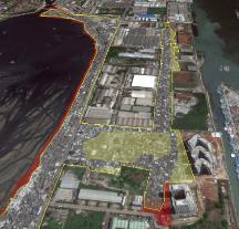
1 Background Image Source bbc.co.uk Human Planet 2011 BBC Earth Observation for Sustainable Development to Support Land Use Planning in Urban Areas Thomas Häusler, Sharon Gomez, Fabian Enssle GAF AG Land and Poverty Conference 2018: Using Satellite Imagery for Urban Change Detection March 19-23, 2018 Washington, DC Lead: Partners: Financed by:

2 The project Earth Observation for Sustainable Development-Urban (EO4SD-Urban) was initiated in May 2016 and is supported by the European Space Agency (ESA). The main objectives are: To improve understanding of EO applications for urban development with the Multi-Lateral Development Banks and developing countries. To mainstream EO applications in an operational manner into development programmes. Phase 1 was completed successfully by end of Phase 2 now continues with new Cities and Stakeholders. Land and Poverty Conference 2018, March 19-23, 2018 Page 2


3 EO Products for Urban Development Green Areas/Networks Urban Extent and Change Building Footprint Population Density Waste Sites Baseline Products Urban and Peri-Urban LU /LC Detailed Change Transport Infrastructure Informal Settlements Flood Risk Landslide Risk Terrain Motion Land and Poverty Conference 2018, March 19-23, 2018 Page 3

4 Geographic Spread of EO4SD-Urban Cities About 40 cities have been identified and stakeholder engagement initiated. Distributed globally. Include mega-cities and small to medium sized cities. Cover a multitude of urban planning/development issues. Land and Poverty Conference 2018, March 19-23, 2018 Page 4
 3 MDBs: Worldbank, Inter-American Development Bank, Asian Development Bank Land and Poverty Conference 2018, March 19-23,")
5 Phase 1 Cities 16 cities in 9 countries and 3 continents recieved 204 EO4SD-Urban products; (57 Baseline Products, 147 Special Products) 3 MDBs: Worldbank, Inter-American Development Bank, Asian Development Bank Land and Poverty Conference 2018, March 19-23, 2018 Page 5
6 Geographic Spread of EO4SD-Urban Cities Kigali Mandalay Rwanda: Myanmar: Argentinia: Mendoza Cambodia: Phnom Phen Kampong Chhnang Stueng Saen Pursat Serei Saophoan Tanzania: Arusha Kigoma Dodoma India: Kolkata Pakistan: Karachi Indonesia: Denpasar Semarang Bangladesh: Dhaka Land and Poverty Conference 2018, March 19-23, 2018 Page 6
7 Achievements of EO4SD-Urban Phase 1 Baseline LU/LC and Derived Products Products for 2 points in time: 15 Cities LU/LC data for 4 points in time: 2 Cities Flood Risk Products: 6 Cities, Terrain Motion Product: 1 City (Semarang), Building Height data: 1 City (Kigali), Urban Extent/Imperviousness products: 16 Cities for 2 points in time, 6 Cities for 4 points in time. Land and Poverty Conference 2018, March 19-23, 2018 Page 7
 Land and Poverty Conference 2018, March 19-23, 2018")
8 EO Data: VHR Example Worldview 2 & GeoEye 1 Images from: Spatial Resolution: 0.5 m Natural Composite Band Combination: Red, Green, Blue (3, 2, 1) Land and Poverty Conference 2018, March 19-23, 2018 Page 8
 Land")
9 EO Data: HR Example Sentinel 2 Images from: Spatial Resolution: 10 m Natural Composite Band Combination: Red, Green, Blue (4, 3, 2) Land and Poverty Conference 2018, March 19-23, 2018 Page 9

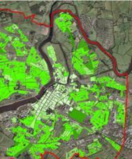
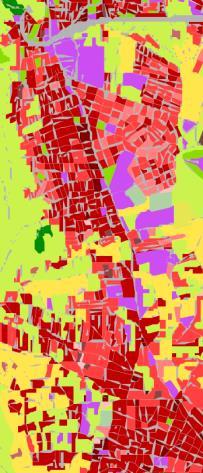
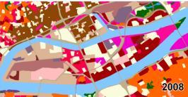
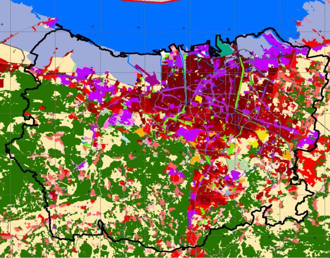
10 Arusha Tanzania: Land Use/Land Cover 2015 Land and Poverty Conference 2018, March 19-23, 2018 Page 10
 Public Buildings Railway")
11 Arusha Tanzania: Land Use/Land Cover 2005 Subset Legend Dodoma_WB_LULC_2016_200 Name_2016, Seal_16 Agricultural Area Airport Arterial Line Bare Soil Cemeteries Collector Line Commercial Area, Construction Site Forest and Shrublands Government Hospitals Industrial Area Land Without Current Use Military Mining/Quarry Areas/DumpSites Natural areas (non-forested) Public Buildings Railway Recreation Facilities Residential, 0-10% Sealed Residential, 10-30% Sealed Residential, 30-50% Sealed Residential, 50-80% Sealed Residential, % Sealed Schools University Urban Parks Water Wetlands Land and Poverty Conference 2018, March 19-23, 2018 Page 11
 Public Buildings Railway")
12 Arusha Tanzania: Land Use/Land Cover 2015 Subset Legend Dodoma_WB_LULC_2016_200 Name_2016, Seal_16 Agricultural Area Airport Arterial Line Bare Soil Cemeteries Collector Line Commercial Area, Construction Site Forest and Shrublands Government Hospitals Industrial Area Land Without Current Use Military Mining/Quarry Areas/DumpSites Natural areas (non-forested) Public Buildings Railway Recreation Facilities Residential, 0-10% Sealed Residential, 10-30% Sealed Residential, 30-50% Sealed Residential, 50-80% Sealed Residential, % Sealed Schools University Urban Parks Water Wetlands Land and Poverty Conference 2018, March 19-23, 2018 Page 12


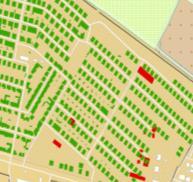
13 Arusha - Land Use Land Cover Change Residential densification is more dominant in Peri-urban zone Residential extension is more dominant in Core Urban zone Land and Poverty Conference 2018, March 19-23, 2018 Page 13


14 Arusha Unplanned vs planned Settlements Unplanned areas continue to expand (more than planned areas) in Core Area Land and Poverty Conference 2018, March 19-23, 2018 Page 14

15 Transport Network of Arusha in 2005 and 2015 Land and Poverty Conference 2018, March 19-23, 2018 Page 15

16 Changes of Urban Green Areas - Dodoma Land and Poverty Conference 2018, March 19-23, 2018 Page 16

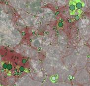
17 Dodoma Tanzania: Population Distribution Change Map Land and Poverty Conference 2018, March 19-23, 2018 Page 17
18 6 10'0"S 6 12'0"S , , '0"E 35 42'0"E 35 44'0"E 35 44'0"E 35 46'0"E 35 46'0"E 6 10'0"S 6 12'0"S Dodoma Tanzania: Population Distribution Change Map Subset , , , Changes in Population Distribution Unchanged Population Distribution Up to -100% decrease Up to 200% increase 201% - 400% increase , % - 600% increase 601% - 800% increase 801% % increase More than 1000% increase Overview Map , , Esri, HERE, DeLorme, MapmyIndia, OpenStreetMap contributors, and the GIS user community Dodoma Core Urban Districts Land and Poverty Conference 2018, March 19-23, 2018 Page 18


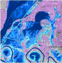
19 Semarang Indonesia: Flood Risk Map Requires precise DTM modelling adequate EO archive data coverage Land and Poverty Conference 2018, March 19-23, 2018 Page 19

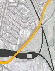
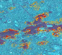
20 Semarang Indonesia: Terrain and Infrastructure Motion Land and Poverty Conference 2018, March 19-23, 2018 Page 20


21 Urban LULC Urban LULC Change Peri-Urban LULC Peri-Urban LULC Change Urban Extent Imperviousness Urban Green Areas Urban Green Areas Change Extent and Type of Informal Settlements Extent and Type of Informal Settlements Change Waste Sites Waste Sites Change Flood History, Flood Risk & Associated Infrastructure Exposure Accuracy Assessment Statistically & Scientifically Sound Sampling Design Stratified Random Sampling Number of samples per strata Expected accuracy, acceptable error, 95% C.L. Response Design Independent reinterpretation Analysis Design Error matrix Metrics (overall, user s, producer s acc.) LULC, Green Areas, Planned and Un-planned Settlements 95% 94% 93% 92% 91% 90% 89% 88% 87% 86% Transport network Land and Poverty Conference 2018, March 19-23, 2018 Page 21


22 Transparent Methods - Quality - Accuracy Service Operations Report for each City Requirements Area of Interest Products Specifications Description of: Methodology Accuracy Assessment Quality Control Sheets Structure Distribution Hazard & Risk Statistics Evolution Integration with.. Land and Poverty Conference 2018, March 19-23, 2018 Page 22


23 Quality Control and Assurance Documentation of QC checks EO & ancillary data, interim & final products Accuracy, consistency, completeness Formalisation and consolidation into QC Sheets Land and Poverty Conference 2018, March 19-23, 2018 Page 23
24 Value of EO4SD-Urban Services Product generation is based on: Verified user requirements Harmonised and standardised state-of-the-art methodologies Comprehensive and transparent documentation Application of statistically sound accuracy assessment Stringent Quality Control and transparent documentation User feedback to improve the services Geospatial products can be used to monitor SDG 11 Indicators Land and Poverty Conference 2018, March 19-23, 2018 Page 24

25 SDG Indicators which can use EO Target 11.1: Housing and slums Target 11.2: Transport Target 11.3: Planning Target 11.7: Public space Indicators: : Proportion of urban population living in slums, informal settlements or inadequate housing : Proportion of the population that has convenient access to public transport by sex, age and persons with disabilities : Ratio of land consumption rate to population growth rate : Average share of the built-up area of cities that is open space for public use for all, by sex, age and persons with disabilities Land and Poverty Conference 2018, March 19-23, 2018 Page 25


 Buffer Analysis: Input Data: EO4SD-Urban")
26 Spatial Data for Monitoring SDG 11 Indicator Target 11.2: Transport : Proportion of the population that has convenient access to public transport by sex, age and persons with disabilities % with access to Public transport =100x (population with convenient access to Public transport (City Population) Buffer Analysis: Input Data: EO4SD-Urban Population Product Census Data per Ward Level for 2013 Other Spatial Data: Public Transport Stations (BRT, Angkot) Census Data per Ward Level for 2013 Results: Land and Poverty Conference 2018, March 19-23, 2018 Page 26

 = Land consumption")


27 Spatial Data for Monitoring SDG 11 Indicator Target 11.3: Planning : Ratio of land consumption rate to population growth rate Input Data: Ratio of land consumption rate to population growth rate (LCRPGR) = Land consumption rate Annual population growth rate EO4SD Build-up Area Arusha Other Spatial Data: World Population Grid from the Global Human Settlements Layer (GHSL) Results: EO4SD Population Distribution Arusha Land and Poverty Conference 2018, March 19-23, 2018 Page 27
28 Conclusions Positive feedback from the different stakeholders of the MDB programmes. The importance of rigorous QC, documentation of methods and results cannot be overstated as it has a direct impact on issues of transparency, repeatability, completeness and validity of the products. Phase 2: processing of geo-spatial products for additional Urban Projects in the different geographical regions will continue. Emphasis will be given on spatial analytics for urban planning. Stakeholder feedback at the end of the Project will provide an overview of the of the utility of the geo-spatial products for urban planning. This should support mainstreaming EO into urban programmes. Land and Poverty Conference 2018, March 19-23, 2018 Page 28
29 Thank you for your attention Thank you for your attention GAF AG GAF Dr. AG Thomas Haeusler (Co-ordinator) Dr. Dr. Thomas Sharon Haeusler Gomez (Co-ordinator) Dr. Arnulfstr.199, Sharon Gomez Munich - Arnulfstr.199, GERMANY Munich - GERMANY thomas.haeusler@gaf.de thomas.haeusler@gaf.de sharon.gomez@gaf.de sharon.gomez@gaf.de Lead: Partners: Financed by: Lead: Partners: Financed by: Land and Poverty Conference 2018, March 19-23, 2018 Page 29
Supporting GPSC Cities with Satellite Earth Observation for Sustainable Urban Development
 Supporting GPSC Cities with Satellite Earth Observation for Sustainable Urban Development Global Platform for Sustainable Cities African Regional Workshop 14 May 2018 AfDB Headquarters Abidjan, Côte d'ivoire
Potential of Earth Observation to address global challenges of cities
 Potential of Earth Observation to address global challenges of cities Copernicus for Future cities workshop, 9 November 2018, Brussels Session III: cities challenges, user needs and innovation paths Marc
SUPPORTS SUSTAINABLE GROWTH
 DDSS BBUUN NDDLLEE G E O S P AT I A L G O V E R N A N C E P A C K A G E SUPPORTS SUSTAINABLE GROWTH www.digitalglobe.com BRISBANE, AUSTRALIA WORLDVIEW-3 30 CM International Civil Government Programs US
Georeferencing and Satellite Image Support: Lessons learned, Challenges and Opportunities
 Georeferencing and Satellite Image Support: Lessons learned, Challenges and Opportunities Shirish Ravan shirish.ravan@unoosa.org UN-SPIDER United Nations Office for Outer Space Affairs (UNOOSA) UN-SPIDER
Measuring Disaster Risk for Urban areas in Asia-Pacific
 Measuring Disaster Risk for Urban areas in Asia-Pacific Acknowledgement: Trevor Clifford, Intl Consultant 1 SDG 11 Make cities and human settlements inclusive, safe, resilient and sustainable 11.1: By
Copernicus Overview. Major Emergency Management Conference Athlone 2017
 Copernicus Overview Major Emergency Management Conference Athlone 2017 Copernicus is a European programme implemented by the European Commission. The services address six thematic areas: land, marine,
Measuring and Monitoring SDGs in Portugal: Ratio of land consumption rate to population growth rate Mountain Green Cover Index
 Measuring and Monitoring SDGs in Portugal: 11.3.1Ratio of land consumption rate to population growth rate 15.4.2 Mountain Green Cover Index United Nations World Geospatial Information Congress João David
Presented to Sub-regional workshop on integration of administrative data, big data and geospatial information for the compilation of SDG indicators
 Presented to Sub-regional workshop on integration of administrative data, big data and geospatial information for the compilation of SDG indicators 23-25 April,2018 Addis Ababa, Ethiopia By: Deogratius
Swedish examples on , and
 Swedish examples on 11.2.1, 11.3.1 and 11.7.1 Marie Haldorson, Director Seminar in Nairobi 7 Dec 2018 SDG Indicator Tests by Countries in Europe GEOSTAT 3: ESS Project with a purpose to guide countries
Dar es Salaam - Reality Check Workshop
 Dar es Salaam - Reality Check Workshop hosted by GIZ and Dar es Salaam City Council Introduction: Key Urban Characteristics of Dar es Salaam Challenges and Opportunities for Resilient Development in the
Indicator : Average share of the built-up area of cities that is open space for public use for all, by sex, age and persons with disabilities
 Goal 11: Make cities and human settlements inclusive, safe, resilient and sustainable Target 11.7: By 2030, provide universal access to safe, inclusive and accessible, green and public spaces, in particular
Operational Definitions of Urban, Rural and Urban Agglomeration for Monitoring Human Settlements
 Operational Definitions of Urban, Rural and Urban Agglomeration for Monitoring Human Settlements By Markandey Rai United Nations Human Settlements Programme PO Box-30030 Nairobi, Kenya Abstract The United
Urban Land Growth Mapping of South-East Asia Cities
 Urban Land Growth Mapping of South-East Asia Cities This document represents additional information accompanying the poster ID 1143 in session "Land Posters" Authors: Jan Kolomazník, Václav Stonáček, Tomáš
Spanish national plan for land observation: new collaborative production system in Europe
 ADVANCE UNEDITED VERSION UNITED NATIONS E/CONF.103/5/Add.1 Economic and Social Affairs 9 July 2013 Tenth United Nations Regional Cartographic Conference for the Americas New York, 19-23, August 2013 Item
Earth Observations as a Tool To Achieve Sustainable Development Goals
 The image part with relationship ID rid3 was not found in the file. 16/10/2017 Earth Observations as a Tool To Achieve Sustainable Development Goals LI Jing, China GEO On behalf of the Group on Earth Observations
Earth Observation & GeoSpatial Information for Monitoring Urban SDG Indicators. Global Urbanization Trend
 Earth Observation & GeoSpatial Information for Monitoring Urban SDG Indicators Yifang Ban, Professor Director, Division of Geoinformatics Vice Chair, Department for Urban Planning and Environment KTH Royal
Applied spatial data for sustainable development strategy in Germany
 Applied spatial data for sustainable development strategy in Germany Stephan Arnold Areal Statistics, Federal Statistical Office, Germany Federal Statistical Office Headquarter: Wiesbaden Branch Office:
Applying Hazard Maps to Urban Planning
 Applying Hazard Maps to Urban Planning September 10th, 2014 SAKAI Yuko Disaster Management Expert JICA Study Team for the Metro Cebu Roadmap Study on the Sustainable Urban Development 1 Contents 1. Outline
Plan4all (econtentplus project)
") Plan4all (econtentplus project) Karel CHARVAT 1, Tomáš MILDORF 2 1 Help service remote sensing, Ltd., Černoleská 1600, 256 01 Benešov u Prahy, Czech Republic charvat@bnhelp.cz 2 Department of Mathematics
Plan4all (econtentplus project) Karel CHARVAT 1, Tomáš MILDORF 2 1 Help service remote sensing, Ltd., Černoleská 1600, 256 01 Benešov u Prahy, Czech Republic charvat@bnhelp.cz 2 Department of Mathematics
How the science of cities can help European policy makers: new analysis and perspectives
 How the science of cities can help European policy makers: new analysis and perspectives By Lewis Dijkstra, PhD Deputy Head of the Economic Analysis Unit, DG Regional and European Commission Overview Data
AFRICAN URBANIZATION: SOME KEY ISSUES. Patricia Jones University of Oxford IGC Conference, Dar es Salaam 25 th February 2015
 AFRICAN URBANIZATION: SOME KEY ISSUES Patricia Jones University of Oxford IGC Conference, Dar es Salaam 25 th February 2015 Introduction New project on urbanization in Africa. World Bank funded but independent
International Conference Analysis and Management of Changing Risks for Natural Hazards November 2014 l Padua, Italy
 Abstract Code: B01 Assets mapping products in support of preparedness and prevention measures (examples from Germany, Italy and France) Marc Mueller, Thierry Fourty, Mehdi Lefeuvre Airbus Defence and Space,
Geospatial Information and Services for Disasters (GIS4D)
") Geospatial Information and Services for Disasters (GIS4D) 31 July 2017 Tae Hyung KIM ICT and Disaster Risk Reduction Division (IDD) UNESCAP 1 About ESCAP Who is ESCAP? United Nations Economic and Social
Geospatial Information and Services for Disasters (GIS4D) 31 July 2017 Tae Hyung KIM ICT and Disaster Risk Reduction Division (IDD) UNESCAP 1 About ESCAP Who is ESCAP? United Nations Economic and Social
KENYA NATIONAL BUREAU OF STATISTICS Workshop on
 KENYA NATIONAL BUREAU OF STATISTICS Workshop on Capacity Building in Environment Statistics: the Framework for the Development of Environment Statistics (FDES 2013) Coordination with Sector Ministries
Developing a global, people-based definition of cities and settlements
 Developing a global, people-based definition of cities and settlements Cooperation between: Directorate General for Regional and, Joint Research Centre, EUROSTAT (European Commission, European Union) OECD,
The Global Statistical Geospatial Framework and the Global Fundamental Geospatial Themes
 The Global Statistical Geospatial Framework and the Global Fundamental Geospatial Themes Sub-regional workshop on integration of administrative data, big data and geospatial information for the compilation
Preparation of Database for Urban Development
 Preparation of Database for Urban Development By PunyaP OLI, 1. Chairman, ERMC (P) Ltd., Kathmandu, Nepal. Email: punyaoli@ermcnepal.com 2. Coordinator, Himalayan College of Geomatic Engineering and Land
Disaster Management & Recovery Framework: The Surveyors Response
 Disaster Management & Recovery Framework: The Surveyors Response Greg Scott Inter-Regional Advisor Global Geospatial Information Management United Nations Statistics Division Department of Economic and
Land Monitoring Core Service Implementation Group (LMCS IG) - Results and Outlook
 - Results and Outlook") Land Monitoring Core Service Implementation Group (LMCS IG) - Results and Outlook Pr. Dietmar Grünreich, President of BKG, Germany Chairman of the GMES LMCS IG Outline 1 Introduction 2 Preparatory Projects
Land Monitoring Core Service Implementation Group (LMCS IG) - Results and Outlook Pr. Dietmar Grünreich, President of BKG, Germany Chairman of the GMES LMCS IG Outline 1 Introduction 2 Preparatory Projects
Copernicus Land HRL Imperviousness: 2012 dataset, indicator Title
 Copernicus Land HRL Imperviousness: 2012 dataset, 06-09 indicator and outlook Title 2015+ Tobias LANGANKE First name SURNAME Project manager, Copernicus Position land services Name European of the Environment
Estimation of the area of sealed soil using GIS technology and remote sensing
 From the SelectedWorks of Przemysław Kupidura 2010 Estimation of the area of sealed soil using GIS technology and remote sensing Stanisław Białousz Przemysław Kupidura Available at: https://works.bepress.com/przemyslaw_kupidura/14/
Historical Assessment of Spatial Growth of Built-ups and Metropolitan areas of Delhi and Mumbai in India and Dhaka in Bangladesh
 Historical Assessment of Spatial Growth of Built-ups and Metropolitan areas of Delhi and Mumbai in India and Dhaka in Bangladesh Tomas Soukup, GISAT World Bank HQ, Washington DC Date : 12 April 2011 Introduction
Sharthi Laldaparsad Statistics South Africa, Policy Research & Analysis. Sub-regional workshop on integration of administrative data,
 Sub-regional workshop on integration of administrative data, big data and geospatial information for the compilation of SDG indicators and International Workshop on Global Fundamental Geospatial Data Themes
EO Information Services in support of Satellite Tools for Building Flood Defence Systems in Guyana
 EO Information Services in support of Satellite Tools for Building Flood Defence Systems in Guyana F. N. Koudogbo and A. Arnaud Altamira Information J. Leen, Eurosense World Bank HQ, Washington DC Date
Space Applications for Disaster Risk Reduction and Sustainable Development
 Space Applications for Disaster Risk Reduction and Sustainable Development Space Applications Section (SAS) ICT and Disaster Risk Reduction Division (IDD) UNESCAP Contents I. RESAP Activities 2016-2017
Spatial Analysis of Natural Hazard and Climate Change Risks in Peri-Urban Expansion Areas of Dakar, Senegal
 1 Spatial Analysis of Natural Hazard and Climate Change Risks in Peri-Urban Expansion Areas of Dakar, Senegal URBAN WEEK 2009 BBL Preston Lounge Thursday, March 12, 2009 Christian Hoffmann GeoVille group
EO4SEE - THE PATHFINDER OF OPERATIONAL SATELLITE MONITORING FOR THE REGION OF THE BLACK SEA AND CENTRAL EUROPE
 EO4SEE: Pathfinder assessment for regional high volume data access, processing and information service delivery platforms - South East Region EO4SEE - THE PATHFINDER OF OPERATIONAL SATELLITE MONITORING
Geographic Information Infrastructure and Policy Framework for Sustainable Mountain Development in the Hindu Kush-Himalayas
 Geo SMART ASIA 2017 22-24 August, Kualalampur Geographic Information Infrastructure and Policy Framework for Sustainable Mountain Development in the Hindu Kush-Himalayas Basanta Shrestha, Director Strategic
The Combination of Geospatial Data with Statistical Data for SDG Indicators
 Session 3: Sustainable Development Goals, SDG indicators The Combination of Geospatial Data with Statistical Data for SDG Indicators Pier-Giorgio Zaccheddu (with the assistance of Francisco Vala & Cátia
Challenges and Successes in Sharing Geospatial Data in Africa
 Challenges and Successes in Sharing Geospatial Data in Africa 2018 GeoNode Summit Torino, Italy March 26-28, 2018 Bernard Justus Muhwezi Manager, Geo-Information Services Uganda Bureau of Statistics, Kampala,
ENV208/ENV508 Applied GIS. Week 1: What is GIS?
 ENV208/ENV508 Applied GIS Week 1: What is GIS? 1 WHAT IS GIS? A GIS integrates hardware, software, and data for capturing, managing, analyzing, and displaying all forms of geographically referenced information.
Chapter 1 Data Collection
 Chapter 1 Data Collection 1. Climate of Brunei Darussalam and Temburong District Situated at around four degrees north of the Equator, Brunei Darussalam enjoys an equatorial climate with an abundance of
Sustainable and Harmonised Development for Smart Cities The Role of Geospatial Reference Data. Peter Creuzer
 Sustainable and Harmonised Development for Smart Cities The Role of Geospatial Reference Data Peter Creuzer 1. Introduction - Smart Cities and Geodata 2. Geodata in Germany 3. Examples 4. Data and Service
Global City Definition
 Regional Training Workshop on Human Settlement Indicators Global City Definition Dennis Mwaniki Global Urban Observatory, Research and Capacity Development Branch, UN-Habitat Bangkok, Thailand Outline
Work Group A «Core Data» Report and Update François Chirié, Dominique Laurent, France
 JOINT UN-GGIM: EUROPE ESS MEETING ON THE INTEGRATION OF STATISTICAL AND GEOSPATIAL INFORMATION LUXEMBOURG 11 MARCH 2016 Work Group A «Core Data» Report and Update François Chirié, Dominique Laurent, France
EO Information Services. Assessing Vulnerability in the metropolitan area of Rio de Janeiro (Floods & Landslides) Project
 Project") EO Information Services in support of Assessing Vulnerability in the metropolitan area of Rio de Janeiro (Floods & Landslides) Project Ricardo Armas, Critical Software SA Haris Kontoes, ISARS NOA World
EO Information Services in support of Assessing Vulnerability in the metropolitan area of Rio de Janeiro (Floods & Landslides) Project Ricardo Armas, Critical Software SA Haris Kontoes, ISARS NOA World
Compact guides GISCO. Geographic information system of the Commission
 Compact guides GISCO Geographic information system of the Commission What is GISCO? GISCO, the Geographic Information System of the COmmission, is a permanent service of Eurostat that fulfils the requirements
Space for Sustainable Development
 Space for Sustainable Development ESA s contribution to the Where, What, and How of Data Dr. Christoph Aubrecht Directorate of Earth Observation Programmes Science, Applications and Future Technologies
Roles of NGII in successful disaster management
 The Second UN-GGIM-AP Plenary Meeting Roles of NGII in successful disaster management Republic of Korea Teheran Iran 28 October 2013 Sanghoon Lee, Ph.D. NGII Outline Type of Disasters Occur in Korea Practical
Grant Agreement No. EIE/07/595/SI BEn
 Biomass energy register for sustainable site development for European regions Grant Agreement No. EIE/07/595/SI2.499697 BEn Biomass energy register for sustainable site development for European regions
Country Report Nepal Geospatial Data Sharing Initiatives of Survey Department Supporting Disaster Management
 Third JPTM Step 2 for Sentinel Asia 6-8 July, 2010 Manila, The Philippines Country Report Nepal Geospatial Data Sharing Initiatives of Survey Department Supporting Disaster Management Durgendra M Kayastha
Mr. Chairman, Hon ble Ministers, Excellencies, Distinguished participants, Ladies and Gentlemen.
 Ministerial Level Exchange of Views on National Experiences on improving transport connectivity and trade facilitation for the achievement of the SDGs: BHUTAN Mr. Chairman, Hon ble Ministers, Excellencies,
Land Accounts - The Canadian Experience
 Land Accounts - The Canadian Experience Development of a Geospatial database to measure the effect of human activity on the environment Who is doing Land Accounts Statistics Canada (national) Component
The Combination of Geospatial Data with Statistical Data for SDG Indicators
 Session x: Sustainable Development Goals, SDG indicators The Combination of Geospatial Data with Statistical Data for SDG Indicators Pier-Giorgio Zaccheddu Fabio Volpe 5-8 December2018, Nairobi IAEG SDG
RESAP Progress Report
 RESAP Progress Report December 2016 to October 2017 Presentation to the Twenty-first session of the Intergovernmental Consultative Committee on the Regional Space Applications Programme for Sustainable
Mapping Water Resources and Reservoirs for Climate Resilience in Zambezi River Basin
 Mapping Water Resources and Reservoirs for Climate Resilience in Zambezi River Basin Corné van der Sande, NEO BV Senior Advisor Earth Observation Services for Monitoring Drought and Water Resources in
Excel Geomatics. Rajesh Paul Excel Geomatics Pvt. Ltd., Noida February, 2015 India Geospatial Forum, Hyderabad
 Excel Geomatics Geo-marketing for Product Sales and Customer Services Rajesh Paul Excel Geomatics Pvt. Ltd., Noida 10-12 February, 2015 India Geospatial Forum, Hyderabad Presentation Outline About Excel
Geospatial Technologies for Resources Planning & Management
 Geospatial Technologies for Resources Planning & Management Lal Samarakoon, PhD Director, Geoinformatics Center Asian Institute of Technology, Thailand Content Geoinformatics for SDG Information Integration
Historical Assessment of Spatial Growth of Builtups in Metropolitan areas of Delhi and Mumbai in India and Dhaka in Bangladesh
 Historical Assessment of Spatial Growth of Builtups in Metropolitan areas of Delhi and Mumbai in India and Dhaka in Bangladesh Tomas Soukup, GISAT BBL session, World Bank HQ, Washington DC Date : 10 January
URBAN CHANGE DETECTION OF LAHORE (PAKISTAN) USING A TIME SERIES OF SATELLITE IMAGES SINCE 1972
 USING A TIME SERIES OF SATELLITE IMAGES SINCE 1972") URBAN CHANGE DETECTION OF LAHORE (PAKISTAN) USING A TIME SERIES OF SATELLITE IMAGES SINCE 1972 Omar Riaz Department of Earth Sciences, University of Sargodha, Sargodha, PAKISTAN. omarriazpk@gmail.com ABSTRACT
URBAN CHANGE DETECTION OF LAHORE (PAKISTAN) USING A TIME SERIES OF SATELLITE IMAGES SINCE 1972 Omar Riaz Department of Earth Sciences, University of Sargodha, Sargodha, PAKISTAN. omarriazpk@gmail.com ABSTRACT
Working Group on Geospatial Information
 GEO-XIV Plenary Summary Working Group on Geospatial Information 4 th Meeting Lawrence Friedl Argyro Kavvada Group on Earth Observations NASA Earth Science Dec. 6-8, 2017 An intergovernmental organization
Improving rural statistics. Defining rural territories and key indicators of rural development
 Improving rural statistics Defining rural territories and key indicators of rural development Improving rural statistics Improving Rural Statistics In 2016, the Global Strategy to improve Agricultural
Urban Spatial Scenario Design Modelling (USSDM) in Dar es Salaam: Background Information
 in Dar es Salaam: Background Information") Urban Spatial Scenario Design Modelling (USSDM) in Dar es Salaam: Background Information Modelling urban settlement dynamics in Dar es Salaam Revision: 2 (July 2013) Prepared by: Katja Buchta TUM team
Urban Spatial Scenario Design Modelling (USSDM) in Dar es Salaam: Background Information Modelling urban settlement dynamics in Dar es Salaam Revision: 2 (July 2013) Prepared by: Katja Buchta TUM team
A Remote Sensing and GIS approach to trace the Densification in Residential Areas
 A Remote Sensing and GIS approach to trace the Densification in Residential Areas Valliappan AL Assistant Professor, School of Planning and Architecture, Vijayawada, India. Date:11/03/2015 What is Densification?
The UN-GGIM: Europe core data initiative to encourage Geographic information supporting Sustainable Development Goals Dominique Laurent, France
 INSPIRE conference Strasbourg 6 September 2017 The UN-GGIM: Europe core data initiative to encourage Geographic information supporting Sustainable Development Goals Dominique Laurent, France Introduction
International Guidelines on Access to Basic Services for All
 International Guidelines on Access to Basic Services for All Presentation and initials lessons from implementation Accessibility to services in regions and cities : measures and policies, OECD 18 June
KENTUCKY HAZARD MITIGATION PLAN RISK ASSESSMENT
 KENTUCKY HAZARD MITIGATION PLAN RISK ASSESSMENT Presentation Outline Development of the 2013 State Hazard Mitigation Plan Risk Assessment Determining risk assessment scale Census Data Aggregation Levels
Validation and verification of land cover data Selected challenges from European and national environmental land monitoring
 Validation and verification of land cover data Selected challenges from European and national environmental land monitoring Gergely Maucha head, Environmental Applications of Remote Sensing Institute of
Disaggregation according to geographic location the need and the challenges
 International Seminar On United Nations Global Geospatial Information Management Disaggregation according to geographic location the need and the challenges 6 th 7 th November 2018 Tribe Hotel, Nairobi,
MANUAL ON THE BSES: LAND USE/LAND COVER
 6. Environment Protection, Management and Engagement 2. Environmental Resources and their Use 5. Human Habitat and Environmental Health 1. Environmental Conditions and Quality 4. Disasters and Extreme
Diversity of global slum conditions is a universal spatial definition of slums feasible?
 Diversity of global slum conditions is a universal spatial definition of slums feasible? Richard Sliuzas ITC Expert Group Meeting on Slum Mapping 21-23 May 2008 INTERNATIONAL INSTITUTE FOR GEO-INFORMATION
SDG s and the role of Earth Observation
 SDG s and the role of Earth Observation Christian Heipke IPI - Institute for Photogrammetry and GeoInformation Leibniz Universität Hannover Germany Secretary General, ISPRS 1. No Poverty 2. Zero Hunger
GIS as a tool in flood management
 GIS for the United Nations and the International Community Conference Panel: GIS and Capacity - How Territorial Planning Benefits from Geospatial Information 3-5 April 2012 Geneva, Switzerland GIS as a
Spatiotemporal Analysis of Noida, Greater Noida and Surrounding Areas (India) Using Remote Sensing and GIS Approaches
 Using Remote Sensing and GIS Approaches") Spatiotemporal Analysis of Noida, Greater Noida and Surrounding Areas (India) Using Remote Sensing and GIS Approaches Gopal Krishna* Indian Agricultural Research Institute, New Delhi, India ABSTRACT Spatiotemporal
Spatiotemporal Analysis of Noida, Greater Noida and Surrounding Areas (India) Using Remote Sensing and GIS Approaches Gopal Krishna* Indian Agricultural Research Institute, New Delhi, India ABSTRACT Spatiotemporal
Airbus DS Consortium Risk and Recovery. Airbus DS Corporate Presentation
 Airbus DS Consortium Risk and Recovery 1 January, 2017 Airbus DS Corporate Presentation 2 SERTIT s Copernicus EMS mapping service Risk & Recovery and Rapid Mapping Based on our 24/7/365 operational rapid
2 nd Semester. Core Courses. C 2.1 City and Metropolitan Planning. Module 1: Urban Structure and Growth Implications
 2 nd Semester Core Courses C 2.1 City and Metropolitan Planning Module 1: Urban Structure and Growth Implications Growth of cities; cities as engine of growth; urban sprawl; land value, economic attributes
Abstract: Contents. Literature review. 2 Methodology.. 2 Applications, results and discussion.. 2 Conclusions 12. Introduction
 Abstract: Landfill is one of the primary methods for municipal solid waste disposal. In order to reduce the environmental damage and to protect the public health and welfare, choosing the site for landfill
Pacific Catastrophe Risk Assessment And Financing Initiative
 Pacific Catastrophe Risk Assessment And Financing Initiative PALAU September is expected to incur, on average,.7 million USD per year in losses due to earthquakes and tropical cyclones. In the next 5 years,
Regional Training Workshop on Human Settlement Indicators
 Regional Training Workshop on Human Settlement Indicators Module 6 Indicator 11.7.1: Average share of the built-up area of cities that is open space for public use for all, by sex, age and persons with
High Resolution Land Use Information by combined Analysis of Digital Landscape Models and Statistical Data Sets. Tobias Krüger Gotthard Meinel
 High Resolution Land Use Information by combined Analysis of Digital Landscape Models and Statistical Data Sets Tobias Krüger Gotthard Meinel Agenda Monitoring approach Input Data Data Processing Output
ANALYSING THE DIVERSITY OF DEPRIVED AREAS IN MUMBAI, INDIA
 ANALYSING THE DIVERSITY OF DEPRIVED AREAS IN MUMBAI, INDIA MONIKA KUFFER (M.KUFFER@UTWENTE.NL) KARIN PFEFFER, RICHARD SLIUZAS, ISA BAUD, MARTIN VAN MAARSEVEEN Source: Google Earth CONTENT OF PRESENTATION
Local EPM Implementation Process in 5 stages
 Local PM Implementation Process in 5 stages 3. Working groups 1. City nvironmental Profile/ Outlook 5. Consolidation & Institutionalisation 4. Strategy & Action plans 2. City Consultation Urban nvironmental
Pacific Catastrophe Risk Assessment And Financing Initiative
 Pacific Catastrophe Risk Assessment And Financing Initiative TIMOR-LESTE September Timor-Leste is expected to incur, on average, 5.9 million USD per year in losses due to earthquakes and tropical cyclones.
ISTAMBUL April 22, pm
 Global Urban Data Initiative ISTAMBUL April 22, 11-12.30 pm Tokyo Ho Chi Minh Moscow Global Urban Data Initiative Global Urban and DRM Unit LEARN ABOUT: Data Access through PUMA Portal and ESA Urban Thematic
THE ROLE OF GEOSPATIAL AT THE WORLD BANK
 THE ROLE OF GEOSPATIAL AT THE WORLD BANK INSPIRE Conference Barcelona, Spain September 26, 2016 Kathrine Kelm Senior Land Administration Specialist Global Land and Geospatial Unit The World Bank Group
Assessment of Sustainable Land Use within the Town Planning Process Experiences with a Multi Criteria Approach (MCA)
") Assessment of Sustainable Land Use within the Town Planning Process Experiences with a Multi Criteria Approach (MCA) Dipl.-Geogr. Sophie Schetke Dipl.-Ing. Benedikt Frielinghaus, University of Bonn, Germany
Assessment of Sustainable Land Use within the Town Planning Process Experiences with a Multi Criteria Approach (MCA) Dipl.-Geogr. Sophie Schetke Dipl.-Ing. Benedikt Frielinghaus, University of Bonn, Germany
Sustainable Cities and Communities based on Indicators on Urbanization 地理国情监测技术. Prof. Dr. John W. Z. SHI The Hong Kong Polytechnic University
 IAEG- SDGs WG on Geospatial Information, 1 st Expert Group Meeting 12-14 Dec 2016 Mexico City Measure 地理国情监测技术 Sustainable Cities and Communities 专业 based on Indicators on Urbanization Prof. Dr. John W.
Space Application in Support of Land Management for SDG Implementation
 Space Application in Support of Land Management for SDG Implementation Regional Expert Workshop on Land Accounting for SDG Monitoring and Reporting 26 September 2017 Space Application Section Information
March 2007 The Survey Department of Sri Lanka
 Contribution of Survey Department of Sri Lanka for Mitigation of Disasters in Sri Lanka K.A.U.N.Kasthuri Deputy Surveyor General (Information Technology) March 2007 The Survey Department of Sri Lanka 1
Dr Ozlem Adiyaman Earth Sciences and Geo-hazards Risk Reduction Section Division of Ecological and Earth Sciences ( ) NATURAL SCIENCES
 NATURAL SCIENCES") Earth Sciences and Geo-hazards Risk Reduction Section Earth observation with COPERNICUS to : protect, monitor, document, present and share our common heritage, our cultural and natural UNESCO World Heritage
Earth Sciences and Geo-hazards Risk Reduction Section Earth observation with COPERNICUS to : protect, monitor, document, present and share our common heritage, our cultural and natural UNESCO World Heritage
Vulnerability assessment using remote sensing. Achim Roth, Hannes Taubenböck German Aerospace Center, German Remote Sensing Data Center
 Vulnerability assessment using remote sensing Achim Roth, Hannes Taubenböck German Aerospace Center, German Remote Sensing Data Center Risk Hazard - Vulnerability Izmit Earthquake 1999 Folie 2 Risk Hazard
Initiative. Country Risk Profile: papua new guinea. Better Risk Information for Smarter Investments PAPUA NEW GUINEA.
 Pacific Catastrophe Risk Assessment And Financing Initiative PAPUA NEW GUINEA September 211 Country Risk Profile: papua new is expected to incur, on average, 85 million USD per year in losses due to earthquakes
Land Use and Land Cover Mapping and Change Detection in Jind District of Haryana Using Multi-Temporal Satellite Data
 Land Use and Land Cover Mapping and Change Detection in Jind District of Haryana Using Multi-Temporal Satellite Data Ravindra Prawasi, M.P. Sharma, T. P. Babu, Om Pal, Saroj, Kirti Yadav, R.S.Hooda Abstract
Foundation Geospatial Information to serve National and Global Priorities
 Foundation Geospatial Information to serve National and Global Priorities Greg Scott Inter-Regional Advisor Global Geospatial Information Management United Nations Statistics Division UN-GGIM: A global
GEOGRAPHY. Parts/Units Topics Marks. Part A Fundamentals of Human Geography 35. Map Work 5. Part B India: People and Economy 35
 GEOGRAPHY Course Structure Parts/Units Topics Marks Part A Fundamentals of Human Geography 35 Unit 1 Unit 2 Unit 3 Unit 4 Unit 5 Human Geography People Human Activities Transport, Communication & Trade
Sustainable Development Goal 11 and the New Urban Agenda: can planning deliver? Vanessa Watson University of Cape Town 2016
 Sustainable Development Goal 11 and the New Urban Agenda: can planning deliver? Vanessa Watson University of Cape Town 2016 .to reinvigorate the global political commitment to the sustainable development
Crowdsourcing approach for large scale mapping of built-up land
 Crowdsourcing approach for large scale mapping of built-up land Kavinda Gunasekara Kavinda@ait.asia Geoinformatics Center Asian Institute of Technology, Thailand. Regional expert workshop on land accounting
Building Institutional Capacity for Multi-Hazard Early Warning in Asia and the Pacific Subtitle
 Building Institutional Capacity for Multi-Hazard Early Warning in Asia and the Pacific Subtitle Title Keran Wang Chief, Space Applications Section ICT and Disaster Risk Reduction Division 22 May 2018 Pillar
Basic Act on the Advancement of Utilizing Geospatial Information
 Basic Act on the Advancement of Utilizing Geospatial Information (Act No. 63 of May 30, 2007) Table of Contents Chapter I General Provisions (Articles 1 to 8) Chapter II Basic Plan for the Advancement
Opportunities to Improve Ecological Functions of Floodplains and Reduce Flood Risk along Major Rivers in the Puget Sound Basin
 Opportunities to Improve Ecological Functions of Floodplains and Reduce Flood Risk along Major Rivers in the Puget Sound Basin Christopher Konrad, US Geological Survey Tim Beechie, NOAA Fisheries Managing