ISTAMBUL April 22, pm
|
|
|
- Rosamond Douglas
- 5 years ago
- Views:
Transcription


1 Global Urban Data Initiative ISTAMBUL April 22, pm Tokyo Ho Chi Minh Moscow Global Urban Data Initiative Global Urban and DRM Unit LEARN ABOUT: Data Access through PUMA Portal and ESA Urban Thematic Exploitation Platform (TEP) Urban mapping technical specifications New Delhi DISCUSS your data needs DISCOVER possibilities to collaborate with technical partners and data developers Sao Paulo
2 Urbanization and sustainable development The Urban Era Source: United Nations Department of Economic and Social Affairs/Population Division 5. World Urbanization Prospects The 2014 Revision. In future, urban areas will account for: 90% of population growth, 80% of increased prosperity, 60% of energy consumption.
3 Measuring Urban Growth At present there is no global source of information to consistently and reliably monitor urban expansion and population change Wide variety of inconsistent methods in the past resulted in estimations of urban land cover between 0.2 to 3% of land mass Existing sources of data are not comparable because countries define urban extents differently Redefinition of areas from rural to urban frequently lacks actual change in land use and population density
4 Measuring Urban Growth Human Settlements layers Ongoing efforts worldwide indicate a global demand Global Rural-Urban Mapping Project Nightlights and ~1km resolution Lower resolution 1990, 1995, 2000 Sample of cities Global Urban Expansion Atlas/ Solly Angel (200 cities, 1990, 2000, 2013) European Commission / OECD Europe + some of the OECD countries World Bank Regional Urbanization Reviews East Asia using MODIS 500(250m) and South Asia using nightlights Global Human settlements Layer (JRC / EC) (currently in process) Urban Land C 2000 and Urban Expansion University of Wisconsin, Madison Now extended to cover the world at 250 m spatial resolution NOAA s Nightlights Data ASTER Global Urban Area map, AGURAM And others. 4

5 Cairo (EG) Moscow (RU) Paris (FR) Mumbai (IN) Beijing- Tianjing (CN) Measuring Urban Growth Currently available Global Human Settlements layers
 and ESA GlobCover 2009 (309 m spatial resolution) The limited spatial resolution does NOT allow a precise characterization of urban settlements, especially")
6 Measuring Urban Growth Currently available global Human Settlements layers In the last decade several Global Human Settlements Layers (GHSL) have been produced to map human settlements worldwide. NASA MODIS 500 (493 m spatial resolution) and ESA GlobCover 2009 (309 m spatial resolution) The limited spatial resolution does NOT allow a precise characterization of urban settlements, especially in rural and peri-urban areas (characterized by small and scattered villages and towns) 6
7 Key Policy Questions: How are cities changing over time? How much, and in what proportion of uses, is land being consumed for urban development? Where are the areas with the most significant land use change? What are the drivers of urban and other land development, and what new infrastructure will be needed to support this development? What are the possible effects of natural disasters and climate change, and how much of the population and assets will be affected? Key Data Needs: Detailed observation and monitoring Moving from Observing and Monitoring to the evaluation of the effectiveness of policy options and modeling Ie. urban growth scenarios, extent/proximity of green urban areas, accessibility, urban heat islands, etc. integration of geographic and statistical information into toolsets and models Objective: Improved spatial planning based on the high quality and accurate data
8 Fundamental needs identified: - Free or low cost data - Better resolution* & accuracy* of measurements - Fast* and operational* monitoring system to offset the limitations of the existing estimations such as: variability of methodologies and mapping results, their low spatial resolution (250m-2km), and low frequency of updates. Resolution: different urban scales: regional (250m-80m) / city level (30 m/10m/5m) Accuracy: 75-90%, in situ data for validation is key Fast: possibilities of updates every 3-5 years on the regional level and every 1 year on the national level Operational: not R&D! based on the validated algorithms (automated) with quarantined long term (20+ years) data availability Free or low cost data: EMODIS (NASA, free), Envisat (ESA, free), ERS (ESA, free), Landsat (NASA, free), Sentinels (ESA, free)
9 Resolution: different urban scales: regional (250m-80m) / city level (30 m/10m/5m) Accuracy: 75-90%, in situ data for validation is key Fast: decadal is a minimum but true need is in possibilities of updates every 3-5 years on the regional level and every 1 year on the national level Operational: not R&D! based on the validated algorithms, automated system (cf. fast) with quarantined long term (20+ years) input data availability, ability to integrate different sources of data (EO and non EO) Free or low cost data: 1km-10 m - Open & Free (Landsat, Sentinels) INFORMATION! 10-2,5m Low cost, 1$ sq km(high value) (SPOT, RapidEye, DMC, IRS, CBRES,, ) <1m At cost, cost vary (high value) (WorldView, Pleiades, Kompsat,, )
10 Monitoring of human settlements required a breakthrough in observational capacity & analytic tools


")
")


11 Global Urban Footprint MODIS 500 Global Urban Footprint vs. MODIS 500 Rome (IT) Oklahoma City (USA) Saku (JP) Zanzibar (TZ) Credit: DLR/German Space Agency Global Urban Footprint, Satellite data: TerraSarX/TandemX mission


12 Global Coverage 2011/2012 Baseline data Africa East and Central Europe South East Asia Credit: DLR/German Space Agency Global Urban Footprint, Satellite data: TerraSarX/TandemX mission

 Validation (evaluated over 2000 randomly")

13 Global Coverage 2011/2012 Baseline data New Delhi, India original backscattering amplitude extracted speckle divergence Global Urban Footprint New Delhi Area: 88 images (~90,000 km 2 ) Validation (evaluated over 2000 randomly distributed samples): OA% 86.6, Kappa 0.73 Credit: DLR/German Space Agency Global Urban Footprint, Satellite data: TerraSarX/TandemX mission

14 Global Coverage 2011/2012 Baseline data National Demonstrator - Japan Japan: ~800 images Credit: DLR/German Space Agency Global Urban Footprint, Satellite data: TerraSarX/TandemX mission

15 Global Coverage 2011/2012 Baseline data Shanghai, China 80 km Credit: DLR/German Space Agency Global Urban Footprint, Satellite data: TerraSarX/TandemX mission


16 Global Coverage 2011/2012 Baseline data Shanghai, China 80 km Urban Footprint Credit: DLR/German Space Agency Global Urban Footprint, Satellite data: TerraSarX/TandemX mission


 data + Global")
 2010 2000")

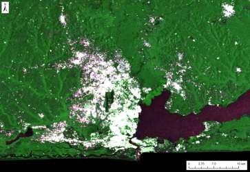
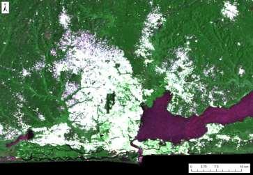
17 Global Coverage 2011/2012 Historical data Urban spatio-temporal development based on historical optical (Landsat MSS, TM and ETM+) and SAR (ERS, ASAR) data + Global Urban Footprint. Manila (Philippines) Credit: DLR/German Space Agency, Satellite data: TerraSarX/TandemX mission, Landsat, ERS, Envisat
 1975 1990 2000 2010")

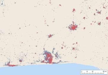
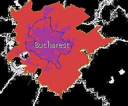
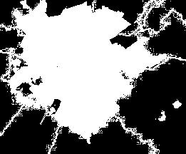
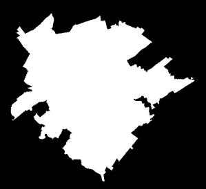
18 Global Coverage 2011/2012 Historical data Istanbul (Turkey) Credit: DLR/German Space Agency, Satellite data: TerraSarX/TandemX mission, Landsat, ERS, Envisat
 Global")


")


19 Seoul (South Korea) Global Coverage 2011/2012 Historical data Jakarta (Indonesia) Credit: DLR/German Space Agency, Satellite data: TerraSarX/TandemX mission, Landsat, ERS, Envisat
20 Phase 1 ( ) : 2014 ESA Innovators Project led by DLR i) the past urban extent ( ) with ASAR WSM data for East Africa; 75m spatial resolution built-up extent It includes entire Uganda, Rwanda, Burundi and Kenya in addition to big parts of Somalia, Ethiopia, South Sudan and Zambia ii) the current urban extent for Addis Ababa, Dar es Salaam and Nairobi from Sentinel-1 IW GRDH data acquired in Phase 2 ( ): i) the past urban extent ( ) with ASAR WSM data of the remaining part of the African continent; ii) the current urban extent for Kigali and entire Uganda (including Kampala) from Sentinel-1 IW GRDH data acquired in


21 Benin Lagos Nigeria Non Urban Urban 2003 Urban 2012 Credit: DLR/German Space Agency, Satellite data: TerraSarX/TandemX mission, Landsat, ERS, Envisat

22 Credit: DLR/German Space Agency, Area of Interest in East Africa

23 Credit: DLR/German Space Agency

24 Credit: DLR/German Space Agency, Global Urban Footprint, Africa, Satellite data: TerraSarX/TandemX mission

25 Credit: DLR/German Space Agency, Global Urban Footprint, Africa, Satellite data: TerraSarX/TandemX mission
 Credit: DLR/German Space")

26 ESA Urban Thematic Exploitation Platform (Urban TEP) Credit: DLR/German Space Agency, GISAT, Brockmann Consult, Terradue, ITI, Urban TEP Kick Off Meeting, Frascati March 2015


27 ESA Urban Thematic Exploitation Platform (Urban TEP) Credit: GISAT, Urban TEP Kick Off Meeting, Frascati March 2015
 computing More data - open")
 MELODIES Credit: GISAT, Urban TEP Kick Off Meeting, Frascati March")
28 Back-end On-demand computation capabilities - modeling, what if support More power, more scalability both for computation, and access demand Through sandboxes/parallel (cloud) computing More data - open data access - EO data and services (Copernicus, Landsat8) catalogues - open data using OpenLinkedData approaches (RDF, SPARC/STRABON) MELODIES Credit: GISAT, Urban TEP Kick Off Meeting, Frascati March 2015
29 ESA Urban Thematic Exploitation Platform (Urban TEP) Multi-scale approach needed reflecting various scales of urban structures for information support. User communities on all levels: Global Regional National Local Credit: GISAT, Urban TEP Kick Off Meeting, Frascati March 2015
30 Example of regional / local dataset European Urban Atlas

31 Example of regional / local dataset European Urban Atlas

32 What are the systems requirements? Example of regional / local dataset European Urban Atlas

33 Example of regional / local dataset European Urban Atlas

34 What are the systems requirements? Example of regional / local dataset European Urban Atlas

35 Example of regional / local dataset European Urban Atlas


36 Example of regional / local dataset European Urban Atlas


37 Example of regional / local dataset European Urban Atlas
38 Global Urban Growth Data Initative Earth observation perspective Anna Burzykowka European Space Agency Department of Science, Applications and Future Tehnologies

39 Global Urban Growth Data Initative Earth observation perspective? Anna Burzykowka? European Space Agency Department of Science, Applications and Future Tehnologies Credit: GISAT, Urban Atlas Plus project
40 Global Urban Growth Data Initative Earth observation perspective Anna Burzykowka European Space Agency Department of Science, Applications and Future Tehnologies

41 Global Urban Growth Data Initative Earth observation perspective? Anna Burzykowka? European Space Agency Department of Science, Applications and Future Tehnologies

42 Delhi, Dhaka, Mumbai - Case studies using European Atlas Methods Credit: GISAT, eoworld project
43 Delhi, Dhaka, Mumbai - Case studies using European Atlas Methods Credit: GISAT, eoworld project

44 Delhi, Dhaka, Mumbai - Case studies using European Atlas Methods Credit: GISAT, eoworld project

45 Delhi, Dhaka, Mumbai - Case studies using European Atlas Methods Credit: GISAT, eoworld project
46 Delhi, Dhaka, Mumbai - Case studies using European Atlas Methods Credit: GISAT, eoworld project


 Rio de Janeiro Manila Cebu")


47 List of cities outside Europe mapped using Urban Atlas methodology Dheli Dhaka Mumbai Lima Bogota Quito Jalalbad Karach Chittagong Colombo Ho Chi Min City Yogyakarta Georgetown (Guyana) Rio de Janeiro Manila Cebu City Hai Phong Surabaya Ulanbaatar Mapping/monitoring principles: - Two to three decades of urban growth 1990, 2000, At least 13 urban classes - Showing land conversions across classes - Using the same definitions for comparable results
48 From maps to indicators Indicator 1: Urban growth Indicator 2: Growth of residential areas Indicator 3: Growth of industrial areas Indicator 4: Urban growth and population development Indicator 5: Productivity of land consumption Indicator 6: Urban sprawl intensity Indicator 7: Land cover replaced by built-up area Indicator 8: Land use Indicator 9: Loss of natural areas Indicator 10: Structural indicators Indicator 11: Informal Settlements

49 Platform for Urban Management and Analysis World Bank EAP Regional Urbanization Flagship // support tool Credit: GISAT for World Bank 49

50 Platform for Urban Management and Analysis World Bank EAP Regional Urbanization Flagship // support tool Credit: GISAT for World Bank 50
51 Platform for Urban Management and Analysis World Bank EAP Regional Urbanization Flagship // support tool Credit: GISAT for World Bank 51

52 Platform for Urban Management and Analysis World Bank EAP Regional Urbanization Flagship // support tool Credit: GISAT for World Bank 52

53 Platform for Urban Management and Analysis World Bank EAP Regional Urbanization Flagship // support tool Credit: GISAT for World Bank 53

54 Platform for Urban Management and Analysis World Bank EAP Regional Urbanization Flagship // support tool Credit: GISAT for World Bank 54

55 Platform for Urban Management and Analysis World Bank EAP Regional Urbanization Flagship // support tool Credit: GISAT for World Bank 55
56 PUMA Examples Credit: GISAT for World Bank 56
57 Measuring Urban Growth Global Urban Unit Data Initiative Phase 1 Creating a Standard Baseline (c.2010) (completed by end 2015) Urban areas definition (based on adapted OECD Methodology) Urban territorial extent (based on Global Urban Footprint) Population distribution data (based on WorldPop) Updated administrative boundaries dataset (as available) Roll out of the PUMA Platform as a WBG urban data hub Phase 2 ( ) Long term monitoring / historical urban change o o o gathering comparable data from prior years, in order to apply track changes in urban extent from (combination of various sources of data Global Human Settlements Layer, GUF, nightlights, Modis250, etc.) updates collected in 2015, which will coincide with the new post-2015 Sustainable Development Goals. Looking beyond urban growth: green cities, natural hazards, climate resilience, urban planning and economic perspective, and so on.
ia PU BLi s g C o M Pa K T Wa i n CD-1576
 M h M y CD-1576 o M Pa g C n ar ia PU BLi s in K T Wa i n ed National Geography Standards National Geography Standards Teachers leading discussions while completing units and activities is a prerequisite
SDI Developments in the World s Currently Existing Mega Cities
 SDI Developments in the World s Currently Existing Mega Cities Silke Boos and Hartmut Müller FIG Working Week 2009 Surveyors Key Role in Accelerated Development, Eilat, Israel, 3-8 May 2009 TS 1B SDI in
Geospatial Information and Services for Disasters (GIS4D)
") Geospatial Information and Services for Disasters (GIS4D) 31 July 2017 Tae Hyung KIM ICT and Disaster Risk Reduction Division (IDD) UNESCAP 1 About ESCAP Who is ESCAP? United Nations Economic and Social
Geospatial Information and Services for Disasters (GIS4D) 31 July 2017 Tae Hyung KIM ICT and Disaster Risk Reduction Division (IDD) UNESCAP 1 About ESCAP Who is ESCAP? United Nations Economic and Social
Earth Observation & GeoSpatial Information for Monitoring Urban SDG Indicators. Global Urbanization Trend
 Earth Observation & GeoSpatial Information for Monitoring Urban SDG Indicators Yifang Ban, Professor Director, Division of Geoinformatics Vice Chair, Department for Urban Planning and Environment KTH Royal
The European Commission s science and knowledge service. Joint Research Centre
 The European Commission s science and knowledge service Joint Research Centre Global Urbanisation Pattern observed with EO data Thomas Kemper & GHSL team Urban Studies Symposium, University of Twente,
Developing a global, people-based definition of cities and settlements
 Developing a global, people-based definition of cities and settlements Cooperation between: Directorate General for Regional and, Joint Research Centre, EUROSTAT (European Commission, European Union) OECD,
EO4SEE - THE PATHFINDER OF OPERATIONAL SATELLITE MONITORING FOR THE REGION OF THE BLACK SEA AND CENTRAL EUROPE
 EO4SEE: Pathfinder assessment for regional high volume data access, processing and information service delivery platforms - South East Region EO4SEE - THE PATHFINDER OF OPERATIONAL SATELLITE MONITORING
Historical Assessment of Spatial Growth of Built-ups and Metropolitan areas of Delhi and Mumbai in India and Dhaka in Bangladesh
 Historical Assessment of Spatial Growth of Built-ups and Metropolitan areas of Delhi and Mumbai in India and Dhaka in Bangladesh Tomas Soukup, GISAT World Bank HQ, Washington DC Date : 12 April 2011 Introduction
Potential of Earth Observation to address global challenges of cities
 Potential of Earth Observation to address global challenges of cities Copernicus for Future cities workshop, 9 November 2018, Brussels Session III: cities challenges, user needs and innovation paths Marc
Supporting GPSC Cities with Satellite Earth Observation for Sustainable Urban Development
 Supporting GPSC Cities with Satellite Earth Observation for Sustainable Urban Development Global Platform for Sustainable Cities African Regional Workshop 14 May 2018 AfDB Headquarters Abidjan, Côte d'ivoire
Sharthi Laldaparsad Statistics South Africa, Policy Research & Analysis. Sub-regional workshop on integration of administrative data,
 Sub-regional workshop on integration of administrative data, big data and geospatial information for the compilation of SDG indicators and International Workshop on Global Fundamental Geospatial Data Themes
Urban Land Growth Mapping of South-East Asia Cities
 Urban Land Growth Mapping of South-East Asia Cities This document represents additional information accompanying the poster ID 1143 in session "Land Posters" Authors: Jan Kolomazník, Václav Stonáček, Tomáš
Module 3 Indicator Land Consumption Rate to Population Growth Rate
 Regional Training Workshop on Human Settlement Indicators Module 3 Indicator 11.3.1 Land Consumption Rate to Population Growth Rate Dennis Mwaniki Global Urban Observatory, Research and Capacity Development
Historical Assessment of Spatial Growth of Builtups in Metropolitan areas of Delhi and Mumbai in India and Dhaka in Bangladesh
 Historical Assessment of Spatial Growth of Builtups in Metropolitan areas of Delhi and Mumbai in India and Dhaka in Bangladesh Tomas Soukup, GISAT BBL session, World Bank HQ, Washington DC Date : 10 January
The International Charter Space and Major Disasters is further strengthening its contribution to disaster management worldwide.
 28 September 2012 Issue 3 The International Charter Space and Major Disasters is further strengthening its contribution to disaster management worldwide. Building on a decade of success in making satellite
EuroGEOSS Protected Areas Pilot
 EuroGEOSS Protected Areas Pilot Max Craglia European Commission Joint Research Centre Part 1: the present MyNatura2000 Mobile app. Awareness raising & volunteered data collection. Natura2000 covers 18%
Space Application in Support of Land Management for SDG Implementation
 Space Application in Support of Land Management for SDG Implementation Regional Expert Workshop on Land Accounting for SDG Monitoring and Reporting 26 September 2017 Space Application Section Information
Copernicus Overview and Emergency Management Service
 Copernicus Overview and Emergency Management Service Frédéric BASTIDE European Commission Open informal session of the United Nations Inter-Agency Meeting on Outer Space Activities 12 March 2013, Geneva
Meeting the Challenges of Earthquake Risk Dynamics and Globalisation
 Check Against Delivery. Embargoed until 4:15 PM, 5 November 2010 Meeting the Challenges of Earthquake Risk Dynamics and Globalisation by Jochen Zschau GFZ German Research Centre for Geosciences, Potsdam,
Open Cities Project. The World Bank, South Asia Region. Background
 Open Cities Project The World Bank, South Asia Region Opencitiesproject.com Background The World Bank s South Asia Region (SAR) is proud to announce its new Open Cities Project. The goal of this project
Migration and Urban Decay
 Migration and Urban Decay Asian Experiences Shekhar Mukherji RAWAT PUBLICATIONS Jaipur New Delhi Bangalore Mumbai Contents Preface List of Tables List of Figures ix xv xix Introduction 1 Very Crucial Urban
The Global Statistical Geospatial Framework and the Global Fundamental Geospatial Themes
 The Global Statistical Geospatial Framework and the Global Fundamental Geospatial Themes Sub-regional workshop on integration of administrative data, big data and geospatial information for the compilation
Current experiences in the use of satellite information in development aid activities
 Current experiences in the use of satellite information in development aid activities Meeting at ESA/ESRIN in Frascati 16 th of September 2017 #WorldInCommon AGENCE FRANÇAISE DE DÉVELOPPEMENT FRENCH DEVELOPMENT
Operational Definitions of Urban, Rural and Urban Agglomeration for Monitoring Human Settlements
 Operational Definitions of Urban, Rural and Urban Agglomeration for Monitoring Human Settlements By Markandey Rai United Nations Human Settlements Programme PO Box-30030 Nairobi, Kenya Abstract The United
AFRICAN URBANIZATION: SOME KEY ISSUES. Patricia Jones University of Oxford IGC Conference, Dar es Salaam 25 th February 2015
 AFRICAN URBANIZATION: SOME KEY ISSUES Patricia Jones University of Oxford IGC Conference, Dar es Salaam 25 th February 2015 Introduction New project on urbanization in Africa. World Bank funded but independent
SAHEL AND. Club WEST AFRICA
 SAHEL AND Club WEST AFRICA Informing policies for Africa s urban future Africa is projected to have the fastest urban growth rate in the world by 2050, Africa s cities will be home to an additional 950
Urban areas & climate change
 Urban areas & climate change Paolo Gamba University of Pavia University of Pavia The UNIPV TLC & RS Lab is a dynamic research group developing in the past years many techniques devoted to the analysis
Developing a global, peoplebased definition of cities and settlements
 Developing a global, peoplebased definition of cities and settlements By Lewis Dijkstra, Lewis.Dijkstra@ec.europa.eu Head of the Economic Analysis Sector DG for Regional and Urban Policy, Regional & Urban
Sommet Mondial des Dirigeants Locaux et Régionaux 4 ème Congrès de CGLU Rabat, 1 er octobre _130 CGLU Rabat
 Mobilité et accessibilité dans les zones urbaines en Afrique : Préparation d un document de synthèse sur les tendances actuelles, les questions émergentes et le choix de stratégies à adopter Sommet Mondial
Land Cover Project ESA Climate Change Initiative. Processing chain for land cover maps dedicated to climate modellers.
 Land Cover Project ESA Climate Change Initiative Processing chain for land cover maps dedicated to climate modellers land_cover_cci S. Bontemps 1, P. Defourny 1, V. Kalogirou 2, F.M. Seifert 2 and O. Arino
Global City Definition
 Regional Training Workshop on Human Settlement Indicators Global City Definition Dennis Mwaniki Global Urban Observatory, Research and Capacity Development Branch, UN-Habitat Bangkok, Thailand Outline
Future perspectives for EO in Development
 Future perspectives for EO in Development Meeting at ESA/ESRIN in Frascati 11 th of September 2018 #WorldInCommon AGENCE FRANÇAISE DE DÉVELOPPEMENT FRENCH DEVELOPMENT AGENCY 01. What is AFD? France s international
Combination of high resolution satellite images population census statistics to estimating population exposed to risks of disaster
 Combination of high resolution satellite images population census statistics to estimating population exposed to risks of disaster Daniel Clarke (UNESCAP) Jean-Louis Weber (Consultant-UNESCAP) Disaster
Land Use / Land Cover Mapping in
 Land Use / Land Cover Mapping in Eastern and Southern African Regions RCMRD Experience by 6/24/2013, Nairobi Kenya Dr. Tesfaye Korme Director of RS, GIS and Mapping, RCMRD I. About RCMRD, Its Vision and
Georeferencing and Satellite Image Support: Lessons learned, Challenges and Opportunities
 Georeferencing and Satellite Image Support: Lessons learned, Challenges and Opportunities Shirish Ravan shirish.ravan@unoosa.org UN-SPIDER United Nations Office for Outer Space Affairs (UNOOSA) UN-SPIDER
Earth Observation for Sustainable Development to Support Land Use Planning in Urban Areas
 Background Image Source bbc.co.uk Human Planet 2011 BBC Earth Observation for Sustainable Development to Support Land Use Planning in Urban Areas Thomas Häusler, Sharon Gomez, Fabian Enssle GAF AG Land
Mapping Global Urban Area from DMSP/OLS Nightlights using a Cluster-based Method
 Mapping Global Urban Area from DMSP/OLS Nightlights using a Cluster-based Method Y. ZHOU, S. SMITH, A. THOMSON, B. BOND-LAMBERTY, M. IMHOFF K. ZHAO, C. ELVIDGE, J. EOM, K. CLARKE Joint Global Change Research
Improving rural statistics. Defining rural territories and key indicators of rural development
 Improving rural statistics Defining rural territories and key indicators of rural development Improving rural statistics Improving Rural Statistics In 2016, the Global Strategy to improve Agricultural
UN COPUOS 52 nd session of the Scientific and Technical Subcommittee. COPERNICUS - an European Achievement. S. Jutz Head, ESA Copernicus Space Office
 UN COPUOS 52 nd session of the Scientific and Technical Subcommittee COPERNICUS - an European Achievement S. Jutz Head, ESA Copernicus Space Office 11 Feb 2015, Vienna 1 2 What is Copernicus? European
sentinel-2 COLOUR VISION FOR COPERNICUS
 sentinel-2 COLOUR VISION FOR COPERNICUS SATELLITES TO SERVE By providing a set of key information services for a wide range of practical applications, Europe s Copernicus programme is providing a step
Cities in Transition: Significance of demographics in shaping development levels
 Cities in Transition: Significance of demographics in shaping development levels Nefise Bazoglu Head, Monitoring Systems Branch UN-HABITAT 22 January 2008 Contents Reactions towards high urbanization Demographic
Copernicus Schaffung einer europäischen Kapazität für die operationelle Erdbeobachtung
 Copernicus Schaffung einer europäischen Kapazität für die operationelle Erdbeobachtung ESOC, Darmstadt, 23 April 2015 Simon Jutz, ESA Head, Copernicus Space Office (EOP-CO) Earth Observation Programmes
LandScan Global Population Database
 LandScan Global Population Database The World s Finest Population Distribution Data Uncommon information. Extraordinary places. LandScan Global Population Database East View Cartographic is now offering
Sentinel-1 Mission Status
 Sentinel-1 Mission Status Pierre Potin, Sentinel-1 Mission Manager, ESA Luca Martino, Technical Support Engineer, ESA... and the Sentinel-1 operations team PSTG SAR Coordination Working Group 14 December
Space research. Horizon Work Programme. "Countdown to Horizon 2020 Space" Earth Observation topics. Brussels, 12 December 2013
 Space research Horizon 2020 - Work Programme "Countdown to Horizon 2020 Space" Earth Observation topics Brussels, 12 December 2013 richard.gilmore@ec.europa.eu Table of contents FP/Copernicus - general
Green areas: numerous positive effects for sustainable metropolis Satellite images : an easy way to map vegetation
 Green areas: numerous positive effects for sustainable metropolis Satellite images : an easy way to map vegetation Copernicus Training and Information Session 10 and 11 may 2017 in Lund, Sweden Dominique
Central Valley School District Social Studies Curriculum Map Grade 7. August - September
 August - September Geographical/Historical Skills Identify and analyze timelines. Construct and use cause and effect charts. Differentiate between fact and opinion. Use of word webs, flip charts, outlines
Multitemporal RADARSAT 2 Fine Beam Polarimetric SAR for Urban Land Cover Mapping
 Multitemporal RADARSAT 2 Fine Beam Polarimetric SAR for Urban Land Cover Mapping Yifang Ban & Xin Niu KTH Royal Institute of Technology Stockholm, Sweden Introduction Urban represents one of the most dynamic
SDG s and the role of Earth Observation
 SDG s and the role of Earth Observation Christian Heipke IPI - Institute for Photogrammetry and GeoInformation Leibniz Universität Hannover Germany Secretary General, ISPRS 1. No Poverty 2. Zero Hunger
Building Institutional Capacity for Multi-Hazard Early Warning in Pacific Countries Subtitle
 Building Institutional Capacity for Multi-Hazard Early Warning in Pacific Countries Subtitle Title Keran Wang Chief, Space Applications Section ICT and Disaster Risk Reduction Division 30 March 2018 Slide
Flood impact assessment using remote sensing
 Aerial view of the 2013 Jan flood in Limpopo river, near Xaixai, Mozambique Flood impact assessment using remote sensing 3rd Workshop on Global Flood Risk 4-6 March, 2013, University of Maryland Alanna
ESA Climate Change Initiative
 ESA Climate Change Initiative Olivier Arino Frascati, 23 June 2009 Climate Change Initiative Rationale Two climate action paths GCOS-82 in 2003 GCOS-92 in 2004 GCOS-107 in 2006 CEOS response 2006 GEOSS
City definitions. Sara Ben Amer. PhD Student Climate Change and Sustainable Development Group Systems Analysis Division
 City definitions Sara Ben Amer PhD Student Climate Change and Sustainable Development Group Systems Analysis Division sbea@dtu.dk Contents 1. Concept of a city 2. Need for the city definition? 3. Challenges
Mapping Water Resources and Reservoirs for Climate Resilience in Zambezi River Basin
 Mapping Water Resources and Reservoirs for Climate Resilience in Zambezi River Basin Corné van der Sande, NEO BV Senior Advisor Earth Observation Services for Monitoring Drought and Water Resources in
Using Geospatial Data to Track Changes in Urbanization
 CASE STUDY Using Geospatial Data to Track Changes in Urbanization Resilient Cities NEAR-TERM Inclusive Cities HIGHLIGHTS PUBLIC POLICY USES FOR EO BIG DATA Analysis of Earth observation (EO) big data from
Urban Expansion. Urban Expansion: a global phenomenon with local causes? Stephen Sheppard Williams College
 Urban Expansion: a global phenomenon with local causes? Stephen Sheppard Williams College Presentation for World Bank, April 30, 2007 Presentations and papers available at http://www.williams.edu/economics/urbangrowth/homepage.htm
U s i n g t h e E S A / E U M E T C A S T N a v i g a t o r s
 U s i n g t h e E S A / E U M E T C A S T N a v i g a t o r s Copernicus User Uptake Information Sessions Copernicus EU Copernicus EU Copernicus EU www.copernicus.eu I N T R O D U C T I O N O F U S E C
IAEG-SDGs WGGI 5 th expert meeting 6 and 8 December 2018, Nairobi, Kenya
 Agenda item #4 Task Stream #2 Application of Satellite Earth Observation Data for the SDG indicators IAEG-SDGs WGGI 5 th expert meeting 6 and 8 December 2018, Nairobi, Kenya Chu Ishida, JAXA, EO4SDG Co-lead
Towards eenvironment Prague, March GMES Space Component. Josef Aschbacher Head, ESA GMES Space Office
 Towards eenvironment Prague, 25-27 March 2009 GMES Space Component Josef Aschbacher Head, ESA GMES Space Office Prague from Space Segment 2 05 Nov 2003 CNES 2003 GISAT 2007 ESA GSELAND GMES is an EU led
Building Institutional Capacity for Multi-Hazard Early Warning in Asia and the Pacific Subtitle
 Building Institutional Capacity for Multi-Hazard Early Warning in Asia and the Pacific Subtitle Title Keran Wang Chief, Space Applications Section ICT and Disaster Risk Reduction Division 22 May 2018 Pillar
DEFINING AND MEASURING WORLD-METRO REGIONS FOR INTERNATIONAL COMPARISONS
 DEFINING AND MEASURING WORLD-METRO REGIONS FOR INTERNATIONAL COMPARISONS Mario Piacentini, OECD 27th Scorus Conference, 11-13 August 2010, Latvia Why we need comparable measures of city performance Growing
Urban Mapping & Change Detection. Sebastian van der Linden Humboldt-Universität zu Berlin, Germany
 Urban Mapping & Change Detection Sebastian van der Linden Humboldt-Universität zu Berlin, Germany Introduction - The urban millennium Source: United Nations Introduction Text Source: Google Earth Introduction
Uchiyama, Yuta & Okabe, Akiko Categorization of 48 Mega-Regions by Spatial Patterns of Population Distribution 48 th ISOCARP Congress 2012
 Categorization of 48 Mega-Regions by Spatial Patterns of Population Distribution: The Relationship between Spatial Patterns and Population Change Comparative Study of Mega-regions: Toward a Dynamic Observation
African requirements for SDI standardization Antony Cooper Operating Unit Fellow Built Environment CSIR PO Box 395, Pretoria, 0001, South Africa
 ISO/TC 211 workshop on spatial data infrastructures (SDIs) African requirements for SDI standardization Antony Cooper Operating Unit Fellow Built Environment CSIR PO Box 395, Pretoria, 0001, South Africa
EO Information Services. Assessing Vulnerability in the metropolitan area of Rio de Janeiro (Floods & Landslides) Project
 Project") EO Information Services in support of Assessing Vulnerability in the metropolitan area of Rio de Janeiro (Floods & Landslides) Project Ricardo Armas, Critical Software SA Haris Kontoes, ISARS NOA World
EO Information Services in support of Assessing Vulnerability in the metropolitan area of Rio de Janeiro (Floods & Landslides) Project Ricardo Armas, Critical Software SA Haris Kontoes, ISARS NOA World
Launch of the ESPON 2013 Programme. European observation network on territorial development and cohesion
 Launch of the ESPON 2013 Programme European observation network on territorial development and cohesion Framework conditions for the ESPON 2013 Programme Policy development in use of territorial evidence
Copernicus Opportunities and Challenges in Europe s eyes on Earth
 Copernicus Opportunities and Challenges in Europe s eyes on Earth Gunter Schreier Deputy Director DLR German Remote Sensing Data Center - Earth Observation Center Rotterdam 25. Mai 2016 Sentinel - Missions
Integration of Geo spatial and Statistical Information: The Nepelese Experience
 Integration of Geo spatial and Statistical Information: The Nepelese Experience Krishna Raj B.C. Joint Secretary Ministry of Land Reform and Management, Nepal 11 June, 2014 Presentation Outline The Country
Emergency Management Service (EMS) mapping
 mapping") GMES Emergency Management Service (EMS) mapping Frédéric BASTIDE GMES unit, European Commission UN-SPIDER Expert Meeting: "Crowdsource Mapping for Disaster Risk Management and Emergency Response" 3-5 December,
GMES Emergency Management Service (EMS) mapping Frédéric BASTIDE GMES unit, European Commission UN-SPIDER Expert Meeting: "Crowdsource Mapping for Disaster Risk Management and Emergency Response" 3-5 December,
Economic and Social Council
 United Nations Economic and Social Council Distr.: General 2 July 2012 E/C.20/2012/10/Add.1 Original: English Committee of Experts on Global Geospatial Information Management Second session New York, 13-15
COPERNICUS SPACE DATA OFFER FOR PUBLIC AUTHORITIES DISTRIBUTED BY ESA
 COPERNICUS SPACE DATA OFFER FOR PUBLIC AUTHORITIES DISTRIBUTED BY ESA The Copernicus Space Component Data Access (CSC-DA) service - financed by the EU and operated by ESA - grants National Public Authorities
MONITORING THE ATMOSPHERE, OCEAN AND CLIMATE FROM SPACE
 MONITORING THE ATMOSPHERE, OCEAN AND CLIMATE FROM SPACE TRANSFORMING OUR WORLD MONITORING WEATHER AND CLIMATE FROM SPACE MONITORING THE ATMOSPHERE, OCEAN AND CLIMATE FROM SPACE FOR TRANSFORMING OUR WORLD
2/25/2019. Taking the northern and southern hemispheres together, on average the world s population lives 24 degrees from the equator.
 Where is the world s population? Roughly 88 percent of the world s population lives in the Northern Hemisphere, with about half north of 27 degrees north Taking the northern and southern hemispheres together,
ESPON evidence on European cities and metropolitan areas
 BEST METROPOLISES Final Conference 18 April 2013, Warsaw ESPON evidence on European cities and metropolitan areas Michaela Gensheimer Structure of Intervention Content Part I: What is the ESPON 2013 Programme?
KUNMING FORUM ON UNITED NATIONS GLOBAL GEOSPATIAL INFORMATION MANAGEMENT CITIES OF THE FUTURE: SMART, RESILIENT
 KUNMING FORUM ON UNITED NATIONS GLOBAL GEOSPATIAL INFORMATION MANAGEMENT CITIES OF THE FUTURE: SMART, RESILIENT and SUSTAINABLE Yunnan Zhenzhuang Guest House, Kunming, China 10 12 May 2017 BACKGROUND CONCEPT
International Symposium on Land Cover Mapping for the African Continent. FAO Land Cover Mapping methodology, tools and standards & GLC SHARE database
 International Symposium on Land Cover Mapping for the African Continent June 25-27, 2013 UNEP HQ & RCMRD, Nairobi, Kenya FAO Land Cover Mapping methodology, tools and standards & GLC SHARE database R C
Latitude & Longitude. Worksheets & activities to teach latitude & longitude. Includes notes, activities, review & all answer keys. 11 pages!
 Latitude & Longitude Worksheets & activities to teach latitude & longitude. Includes notes, activities, review & all answer keys. 11 pages! Lines of Latitude & Longitude Name: Lines of latitude and longitude
Space for Sustainable Development
 Space for Sustainable Development ESA s contribution to the Where, What, and How of Data Dr. Christoph Aubrecht Directorate of Earth Observation Programmes Science, Applications and Future Technologies
Evaluating Flood Hazard Potential in Danang City, Vietnam Using FOSS4G
 Free and Open Source Software for Geospatial (FOSS4G) Conference Proceedings Volume 15 Seoul, South Korea Article 28 2015 Evaluating Flood Hazard Potential in Danang City, Vietnam Using FOSS4G An Tran
Challenges for the operational assimilation of satellite image data in agrometeorological models
 Challenges for the operational assimilation of satellite image data in agrometeorological models Mark Danson Centre for Environmental Systems Research, University of Salford, UK 0 Objectives The main objective
Geography. Total marks 100. Section I Pages marks Attempt Questions 1 15 Allow about 25 minutes for this section
 2006 HIGHER SCHOOL CERTIFICATE EXAMINATION Geography Total marks 100 General Instructions Reading time 5 minutes Working time 3 hours Write using black or blue pen Board-approved calculators may be used
World Bank Group GEF Program
 World Bank Group GEF Program Global Environment Facility: -Transport World Bank GEF Coordination Team Content How does GEF work? World Bank s role in the GEF partnership The GEF transport activities What
Building a validation database for land cover products from high spatial resolution images
 Building a validation database for land cover products from high spatial resolution images The Land Cover project of the ESA Climate Change Initiative Bontemps Sophie 1, Achard Frédéric 2, Lamarche Céline
World Urban Database and Access Portal Tools (WUDAPT) Mapping Global Cities by Using a Common Language
 Mapping Global Cities by Using a Common Language") World Urban Database and Access Portal Tools (WUDAPT) Mapping Global Cities by Using a Common Language Prof. Chao REN*,The Chinese University of Hong Kong, Hong Kong Prof. Gerald MILLS, University College
World Urban Database and Access Portal Tools (WUDAPT) Mapping Global Cities by Using a Common Language Prof. Chao REN*,The Chinese University of Hong Kong, Hong Kong Prof. Gerald MILLS, University College
Using Earth Observation Data for Monitoring River Basins
 Using Earth Observation Data for Monitoring River Basins The NBI Experience By Milly Mbuliro GIS/ Remote Sensing Specialist Nile Basin Initiative Secretariat NBDF, 23 rd -25 th October, Kigali Convention
Urbanisation & Economic Geography (2)
") GEOG1101: Introduction to Economic Geography Tuesday 20 October, 2009 Urbanisation & Economic Geography (2) Kevon Rhiney Department of Geography and Geology University of the West Indies, Mona Lecture
GEOG1101: Introduction to Economic Geography Tuesday 20 October, 2009 Urbanisation & Economic Geography (2) Kevon Rhiney Department of Geography and Geology University of the West Indies, Mona Lecture
URBAN CHANGE DETECTION OF LAHORE (PAKISTAN) USING A TIME SERIES OF SATELLITE IMAGES SINCE 1972
 USING A TIME SERIES OF SATELLITE IMAGES SINCE 1972") URBAN CHANGE DETECTION OF LAHORE (PAKISTAN) USING A TIME SERIES OF SATELLITE IMAGES SINCE 1972 Omar Riaz Department of Earth Sciences, University of Sargodha, Sargodha, PAKISTAN. omarriazpk@gmail.com ABSTRACT
URBAN CHANGE DETECTION OF LAHORE (PAKISTAN) USING A TIME SERIES OF SATELLITE IMAGES SINCE 1972 Omar Riaz Department of Earth Sciences, University of Sargodha, Sargodha, PAKISTAN. omarriazpk@gmail.com ABSTRACT
What on Earth is Geography? Using the Five Themes of Geography to Study the Continent of Asia.
 What on Earth is Geography? Using the Five Themes of Geography to Study the Continent of Asia. Name Date Essential questions: 1. How can we study the geography of our Earth? a. What are the five themes
ESCAP Promotes Geo-referenced Information System for Disaster Risk Management in Asia and the Pacific
 Third High Level Forum on UNGGIM 22-24 October 2014 Beijing, China ESCAP Promotes Geo-referenced Information System for Disaster Risk Management in Asia and the Pacific Keran Wang Space Applications Section,
UN-GGIM: An Overview Stefan Schweinfest, Director (UNSD) Bangkok, 27 March 2015
 Bangkok, 27 March 2015") UN-GGIM: An Overview Stefan Schweinfest, Director (UNSD) Bangkok, 27 March 2015 ggim.un.org UN-GGIM: A global initiative Formal inter-governmental UN Committee of Experts to: Discuss, enhance and coordinate
UN-GGIM: An Overview Stefan Schweinfest, Director (UNSD) Bangkok, 27 March 2015 ggim.un.org UN-GGIM: A global initiative Formal inter-governmental UN Committee of Experts to: Discuss, enhance and coordinate
Disaster Management & Recovery Framework: The Surveyors Response
 Disaster Management & Recovery Framework: The Surveyors Response Greg Scott Inter-Regional Advisor Global Geospatial Information Management United Nations Statistics Division Department of Economic and
The Polar Ice Sheets Monitoring Project A Coordinated Response from Space Agencies
 The Polar Ice Sheets Monitoring Project A Coordinated Response from Space Agencies Yves Crevier / Members of the PSTG SAR Coordination WG Canadian Space Agency CEOS SIT-28 Meeting Hampton, Virginia, USA
EO Information Services in support of West Africa Coastal vulnerability Service 2 : Sea Level Height & currents. Vinca Rosmorduc, CLS
 EO Information Services in support of West Africa Coastal vulnerability Service 2 : Sea Level Height & currents Vinca Rosmorduc, CLS World Bank HQ, Washington DC Date : 23 February 2012 West Africa coastal
ESA Climate Change Initiative (CCI)
") ESA Climate Change Initiative (CCI) New ESA Programme with the aim to contribute to worldwide efforts to generate Essential Climate Variables (ECVs) C. Zehner Barcelona, 07/09/2009 Two climate action paths
ESA Climate Change Initiative (CCI) New ESA Programme with the aim to contribute to worldwide efforts to generate Essential Climate Variables (ECVs) C. Zehner Barcelona, 07/09/2009 Two climate action paths
Space Applications for Disaster Risk Reduction and Sustainable Development
 Space Applications for Disaster Risk Reduction and Sustainable Development Space Applications Section (SAS) ICT and Disaster Risk Reduction Division (IDD) UNESCAP Contents I. RESAP Activities 2016-2017
Poland, European Territory, ESPON Programme Warsaw, 2 July 2007 STRATEGY OF THE ESPON 2013 PROGRAMME
 Poland, European Territory, ESPON Programme 2007-2013 Warsaw, 2 July 2007 STRATEGY OF THE ESPON 2013 PROGRAMME Territory matters Regional diversity as asset Territorial potentials increasing in importance
Remote Sensing and EO activities at the University of Turku
 Remote Sensing and EO activities at the University of Turku Niina Käyhkö Associate Professor Department of Geography and Geology GEO meeting/syke May 23rd, 2018 Geospatial competence at the University
EU collaborations with NASA LCLUC Program & Current Priorities
 & Current Priorities ioannis Manakos, Dr. Centre for Research and Technology Hellas Information Technologies Institute Visual Analytics, Virtual & Augmented Reality Laboratory European Association of Remote
Can I have a similar please. Sorry Mister that s the last one
 Can I have a similar please Sorry Mister that s the last one Mega cities 1950 New York London Rhine-Ruhr Moscow Tokyo Shanghai Paris Buenos Aires Mega cities 2015 Population worldwide in cities Tokyo Los
Städte im Klimawandel...
 10.000 Städte im Klimawandel... Was wissen wir dank GIS? Steffen Kriewald 19. November 2014 Global Urbanization: 75% 50% WUP 14 Cities are most responsible for Climate Change... Climate Change highly threatens