AFRICAN URBANIZATION: SOME KEY ISSUES. Patricia Jones University of Oxford IGC Conference, Dar es Salaam 25 th February 2015
|
|
|
- Clarissa Caldwell
- 5 years ago
- Views:
Transcription
1 AFRICAN URBANIZATION: SOME KEY ISSUES Patricia Jones University of Oxford IGC Conference, Dar es Salaam 25 th February 2015
2 Introduction New project on urbanization in Africa. World Bank funded but independent research agenda. Led by joint research team from Oxford University & London School of Economics. Project leaders: Paul Collier (Oxford) Tony Venables (Oxford) Vernon Henderson (LSE)
3 Some Aims of the Project To better understand the spatial development of African cities and the scope for public policy to improve it. We will be examining the patterns, causes, consequences and policy implications of urban development across Sub-Saharan Africa. To compile urbanization. a comprehensive dataset on African Satellite data Historical aerial photos & maps Geo-referenced firm & household data Census data Cadastral surveys, etc.
4 Spatial Analysis Within-cities: to understand the spatial patterns of development within cities and its determinants and implications. Across-cities: to understand how systems of cities have evolved over time.
5 Within-city Analysis We want to know how both populations and capital (buildings and roads) are: Distributed within cities Their evolution over time What drives conversion of rural land to urban use? What about conversion of informal to formal land? Under what circumstances (e.g. economic growth, institutional settings, policy initiatives, etc.) do we see conversion? What drives conversion at fringe (formal vs informal) Densification In-filling vs higher buildings (what would be mostefficient)
6 Within-city Analysis Initially, we will focus on six priority cities (Dar es Salaam, Nairobi, Addis, Kampala, Kigali & Accra) Right now, we have population data, night lights data and low resolution ground cover data ( built or impermeable surface). Have just gotten high resolution (1.5 to 2.5 meter) satellite data Early 2000s and early 2010s. Measures of building density and irregularity of positioning Access to roads Will get some building height data.
7 Preliminary look at Dar es Salaam Has some semblance of a monocentric structure as do most cities in the developing world. Two big differences: Low average density at the center compared to other big cities in developing world especially those at its income level. Extreme extent of unplanned [informal] settlements 80+% of buildings in in unplanned sector
8 Preliminary look at Dar es Salaam Some findings on: Population density and its evolution Built cover (low resolution) Ratio of population to build cover Methodologies that we re using to learn more about built cover and capital investments using high resolution data.

9 Source: NBS Census data and OSM Urban Density
10 Population Density Level (low average) Average density near center is per sq km. Versus, say, Jakarta 1980: 40,000+ Shanghai and many big cities even higher historically, with peaks at 100,000+ per sq km. Density without building height Informal settlements: low livability.
11 Density by distance to major roads
12 Population Density Gradient 30,000 Population Density 25,000 20, People per square km 15,000 10,000 5,000 0 Distance from Centre (km) Source: NBS Census data and OSM
13 Population Density Levels and Changes (1) (2) (3) (4) Log Population Density 2012 Change in Log Population Density Distance to City Centre *** *** *** *** ( ) ( ) ( ) ( ) Distance to Major Roads *** * (0.0319) (0.0164) Log Pop. Density *** *** (0.0495) (0.0542) Constant *** *** *** *** (0.130) (0.119) (0.508) (0.557) Observations Adjusted R INFRASTRUCTURE: Usual decline in density from center but major roads play a significant role in settlement patterns. Future: Effect of BRT or opening of limited access highway on settlement patterns
14 Built area What is covered, or built? What is the density and irregularity of buildings What are their heights? How do these interact with public capital (roads)? How does this evolve over time? Irregular to regular; dense to less dense; Dense and irregular to even more dense; building upward in dense/irregular areas Unserviced to serviced


15 Change at pixel level (30m x 30m); must be one use or another


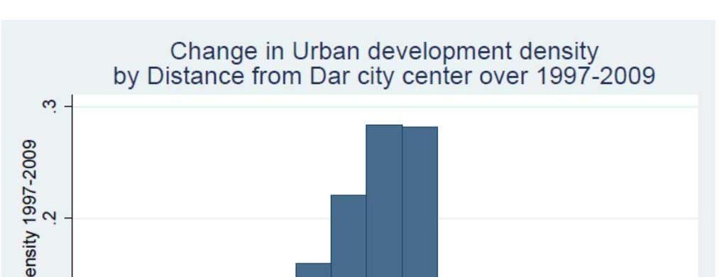
16 % changes also similar in pattern
17 Is the frontier the neighborhoods where there is height?
, Kariakoo and CBD, plus wards just to the south of here. Wards just to NE of airport, and spreading across to Tandika.")
18 Population to built area Areas of greatest increases Tandale, Manzese, Tandika, & Mwananyamala informal settlements to the West. Kigamboni (ward connected by ferry to CBD across creek), Kariakoo and CBD, plus wards just to the south of here. Wards just to NE of airport, and spreading across to Tandika. Suggestive that the informal settlements and densest original places are seeing increased density despite lack of space to develop more land. Interesting to see population spreading north faster than build up increasing This is an area where we are seeing high numbers of formal firms. Also on major road towards Bagamoyo new port


19 Dar es Salaam 2010/12 land cover Land cover was derived from classified VHR imagery
20 Percent of Class by Distance from CBD in K Commercial Residential Ratio Comm/Res Barren


21 The problem of strict classification But 80% of buildings are in unplanned Settlements. UN Habitat (2010) based on government census of buildings. What is the problem: Lots of formal sector land but not buildings? Misclassification Need information about Buildings!
22 Next Step Focus on two key functions of the city: Livability housing quality, especially floor space & height Access to public services Security of tenure Productivity Scale Complementarities
23 Next Step Three complementary spatially specific investment processes: public infrastructure household residential commercial. Timing issues Path dependence Role of public policy
24
Operational Definitions of Urban, Rural and Urban Agglomeration for Monitoring Human Settlements
 Operational Definitions of Urban, Rural and Urban Agglomeration for Monitoring Human Settlements By Markandey Rai United Nations Human Settlements Programme PO Box-30030 Nairobi, Kenya Abstract The United
Achieving the Vision Geo-statistical integration addressing South Africa s Developmental Agenda. geospatial + statistics. The Data Revolution
 Achieving the Vision Geo-statistical integration addressing South Africa s Developmental Agenda geospatial + statistics The Data Revolution humble beginnings, present & future - South Africa UN World Data
Leveraging Urban Mobility Strategies to Improve Accessibility and Productivity of Cities
 Leveraging Urban Mobility Strategies to Improve Accessibility and Productivity of Cities Aiga Stokenberga World Bank GPSC African Regional Workshop May 15, 2018 Roadmap 1. Africa s urbanization and its
Spatial Analysis and Modeling of Urban Land Use Changes in Lusaka, Zambia: A Case Study of a Rapidly Urbanizing Sub- Saharan African City
 Spatial Analysis and Modeling of Urban Land Use Changes in Lusaka, Zambia: A Case Study of a Rapidly Urbanizing Sub- Saharan African City January 2018 Matamyo SIMWANDA Spatial Analysis and Modeling of
Spatial profile of three South African cities
 Spatial Outcomes Workshop South African Reserve Bank Conference Centre Pretoria September 29-30, 2009 Spatial profile of three South African cities by Alain Bertaud September 29 Email: duatreb@msn.com
Sharthi Laldaparsad Statistics South Africa, Policy Research & Analysis. Sub-regional workshop on integration of administrative data,
 Sub-regional workshop on integration of administrative data, big data and geospatial information for the compilation of SDG indicators and International Workshop on Global Fundamental Geospatial Data Themes
Dar es Salaam - Reality Check Workshop
 Dar es Salaam - Reality Check Workshop hosted by GIZ and Dar es Salaam City Council Introduction: Key Urban Characteristics of Dar es Salaam Challenges and Opportunities for Resilient Development in the
Urban Spatial Scenario Design Modelling (USSDM) in Dar es Salaam: Background Information
 in Dar es Salaam: Background Information") Urban Spatial Scenario Design Modelling (USSDM) in Dar es Salaam: Background Information Modelling urban settlement dynamics in Dar es Salaam Revision: 2 (July 2013) Prepared by: Katja Buchta TUM team
Urban Spatial Scenario Design Modelling (USSDM) in Dar es Salaam: Background Information Modelling urban settlement dynamics in Dar es Salaam Revision: 2 (July 2013) Prepared by: Katja Buchta TUM team
Diversity of global slum conditions is a universal spatial definition of slums feasible?
 Diversity of global slum conditions is a universal spatial definition of slums feasible? Richard Sliuzas ITC Expert Group Meeting on Slum Mapping 21-23 May 2008 INTERNATIONAL INSTITUTE FOR GEO-INFORMATION
Urban Expansion. Urban Expansion: a global phenomenon with local causes? Stephen Sheppard Williams College
 Urban Expansion: a global phenomenon with local causes? Stephen Sheppard Williams College Presentation for World Bank, April 30, 2007 Presentations and papers available at http://www.williams.edu/economics/urbangrowth/homepage.htm
Subject: Note on spatial issues in Urban South Africa From: Alain Bertaud Date: Oct 7, A. Spatial issues
 Page 1 of 6 Subject: Note on spatial issues in Urban South Africa From: Alain Bertaud Date: Oct 7, 2009 A. Spatial issues 1. Spatial issues and the South African economy Spatial concentration of economic
Secondary Towns and Poverty Reduction: Refocusing the Urbanization Agenda
 Secondary Towns and Poverty Reduction: Refocusing the Urbanization Agenda Luc Christiaensen and Ravi Kanbur World Bank Cornell Conference Washington, DC 18 19May, 2016 losure Authorized Public Disclosure
Future Visions and Urban Development in Dar es Salaam
 Future Visions and Urban Development in Dar es Salaam There is a building boom in Dar es Salaam. Some of the new skyscrapers include hotels and offices. But most of the space is flats, for example in these
Impact Evaluation of Rural Road Projects. Dominique van de Walle World Bank
 Impact Evaluation of Rural Road Projects Dominique van de Walle World Bank Introduction General consensus that roads are good for development & living standards A sizeable share of development aid and
Vernon Henderson, Anthony J. Venables, Tanner Regan and Ilia Samsonov Building functional cities
 Vernon Henderson, Anthony J. Venables, Tanner Regan and Ilia Samsonov Building functional cities Article (Accepted version) (Refereed) Original citation: Henderson, Vernon, Venables, Anthony J., Regan,
Challenges and Successes in Sharing Geospatial Data in Africa
 Challenges and Successes in Sharing Geospatial Data in Africa 2018 GeoNode Summit Torino, Italy March 26-28, 2018 Bernard Justus Muhwezi Manager, Geo-Information Services Uganda Bureau of Statistics, Kampala,
Cities as Engines of Growth: Evidence from a New Global Sample of Cities
 as Engines of Growth: Evidence from a New Global Sample of Paul Collier Patricia Jones Dewi Spijkerman University of Oxford 28 March 2018 *This work was supported by the Global Research Program on Spatial
Presented to Sub-regional workshop on integration of administrative data, big data and geospatial information for the compilation of SDG indicators
 Presented to Sub-regional workshop on integration of administrative data, big data and geospatial information for the compilation of SDG indicators 23-25 April,2018 Addis Ababa, Ethiopia By: Deogratius
BIG IDEAS. Area of Learning: SOCIAL STUDIES Urban Studies Grade 12. Learning Standards. Curricular Competencies
 Area of Learning: SOCIAL STUDIES Urban Studies Grade 12 BIG IDEAS Urbanization is a critical force that shapes both human life and the planet. The historical development of cities has been shaped by geographic,
The Morphology of African Cities
 Policy Research Working Paper 7911 WPS7911 The Morphology of African Cities Sarah E. Antos Somik V. Lall Nancy Lozano-Gracia Public Disclosure Authorized Public Disclosure Authorized Public Disclosure
Preparing the GEOGRAPHY for the 2011 Population Census of South Africa
 Preparing the GEOGRAPHY for the 2011 Population Census of South Africa Sharthi Laldaparsad Statistics South Africa; E-mail: sharthil@statssa.gov.za Abstract: Statistics South Africa (Stats SA) s Geography
Foundation Geospatial Information to serve National and Global Priorities
 Foundation Geospatial Information to serve National and Global Priorities Greg Scott Inter-Regional Advisor Global Geospatial Information Management United Nations Statistics Division UN-GGIM: A global
Promoting synergy between airports and cities to achieve sustainable development
 Promoting synergy between airports and cities to achieve sustainable development Content 1. Airports / Aviation 2. Urbanization 3. Shared Threads & Opportunities 4. Synergistic Development for Sustainability
Module 3 Indicator Land Consumption Rate to Population Growth Rate
 Regional Training Workshop on Human Settlement Indicators Module 3 Indicator 11.3.1 Land Consumption Rate to Population Growth Rate Dennis Mwaniki Global Urban Observatory, Research and Capacity Development
Environmental Management Information System (EMIS)
") United Nations Human Settlements Programme (UN-HABITAT) United Nations Environment Programme (UNEP) Environmental Management Information System (EMIS) a tool for Environmental Planning and Management (EPM)
United Nations Human Settlements Programme (UN-HABITAT) United Nations Environment Programme (UNEP) Environmental Management Information System (EMIS) a tool for Environmental Planning and Management (EPM)
Spatial information in strategic city planning - Zagreb experience. Darko Šiško City office for strategic planning, Zagreb
 Spatial information in strategic city planning - Zagreb experience Darko Šiško City office for strategic planning, Zagreb Overview Strategic city planning GI tools and trends Spatial data for strategic
Economic and Social Council
 United Nations Economic and Social Council 28 December 2000 Original: English E/CN.3/2001/2 Statistical Commission Thirty-second session 6-9 March 2001 Item 3 (a) of the provisional agenda * Demographic
BELARUS CITIES IN EUROPE AND CENTRAL ASIA METHODOLOGY. Public Disclosure Authorized. Public Disclosure Authorized. Public Disclosure Authorized
 Public Disclosure Authorized Public Disclosure Authorized CITIES IN EUROPE AND CENTRAL ASIA BELARUS Public Disclosure Authorized Public Disclosure Authorized METHODOLOGY This country snapshot was produced
New Partners for Smart Growth: Building Safe, Healthy, and Livable Communities Mayor Jay Williams, Youngstown OH
 New Partners for Smart Growth: Building Safe, Healthy, and Livable Communities Mayor Jay Williams, Youngstown OH The City of Youngstown Youngstown State University Urban Strategies Inc. Youngstown needed
Using Geospatial Data to Track Changes in Urbanization
 CASE STUDY Using Geospatial Data to Track Changes in Urbanization Resilient Cities NEAR-TERM Inclusive Cities HIGHLIGHTS PUBLIC POLICY USES FOR EO BIG DATA Analysis of Earth observation (EO) big data from
NSDI as a tool for Secure land tenure
 NSDI as a tool for Secure land tenure General Overview To look at the progress in SDI development and its application in policy formulation and impact on land tenure. INTEGRATION OF INFORMATION POLICIES
Sharing the wealth across the urban hierarchy in Sub-Saharan African countries: Resource rents and politics
 Sharing the wealth across the urban hierarchy in Sub-Saharan African countries: Resource rents and politics July 12, 2015 Vernon Henderson (LSE), Adam Storeygard (Tufts) and Jamila Nigmatulina (LSE) Motivation:
Cities in Bad Shape: Urban Geometry in India
 Cities in Bad Shape: Urban Geometry in India Mariaflavia Harari MIT IGC Cities Research Group Conference 21 May 2015 Introduction Why Study City Shape A wide range of factors determine intra-urban commuting
Engagement on Strategies to Overcome Inequality
 Engagement on Strategies to Overcome Inequality Civil Society Engagement with Poverty Julian Sendin 1-2 June 2017 Kievits Kroon Country Estate, Pretoria, South Africa 1. Ndifuna Ukwazi Ndifuna Ukwazi is
Measuring Disaster Risk for Urban areas in Asia-Pacific
 Measuring Disaster Risk for Urban areas in Asia-Pacific Acknowledgement: Trevor Clifford, Intl Consultant 1 SDG 11 Make cities and human settlements inclusive, safe, resilient and sustainable 11.1: By
GEORGIA CITIES IN EUROPE AND CENTRAL ASIA METHODOLOGY. Public Disclosure Authorized. Public Disclosure Authorized. Public Disclosure Authorized
 Public Disclosure Authorized Public Disclosure Authorized Public Disclosure Authorized Public Disclosure Authorized CITIES IN EUROPE AND CENTRAL ASIA GEORGIA METHODOLOGY This Country Snapshot was produced
Urban Expansion of the City Kolkata since last 25 years using Remote Sensing
 [ VOLUME 5 I ISSUE 2 I APRIL JUNE 2018] E ISSN 2348 1269, PRINT ISSN 2349-5138 Urban Expansion of the City Kolkata since last 25 years using Remote Sensing Soumita Banerjee Researcher, Faculty Council
SAHEL AND. Club WEST AFRICA
 SAHEL AND Club WEST AFRICA Informing policies for Africa s urban future Africa is projected to have the fastest urban growth rate in the world by 2050, Africa s cities will be home to an additional 950
Stability, Ability and Equity
 Stability, Ability and Equity Mobility and Protection in the Urban Context Arup Banerji Senior Director and Head of Global Practice, Social Protection and Labor The World Bank Group 1 ECONOMIC MOBILITY
Integrated infrastructure planning at metropolitan scale. QII implementation metro-wide (horizontal and vertical coordination)
") Session 10: Working Across Political and Interjurisdictional Boundaries to Realize QII Mats Andersson Integrated infrastructure planning at metropolitan scale QII implementation metro-wide (horizontal
Session 10: Working Across Political and Interjurisdictional Boundaries to Realize QII Mats Andersson Integrated infrastructure planning at metropolitan scale QII implementation metro-wide (horizontal
Earth Observation for Sustainable Development to Support Land Use Planning in Urban Areas
 Background Image Source bbc.co.uk Human Planet 2011 BBC Earth Observation for Sustainable Development to Support Land Use Planning in Urban Areas Thomas Häusler, Sharon Gomez, Fabian Enssle GAF AG Land
Vienna urban development - seestadt aspern as urban future lab
 Vienna urban development - seestadt aspern as urban future lab PERMACULTURE DESIGN COURSE * 2012 * ASPERN SEESTADT 1 Christof Schremmer, ÖIR Austrian Institute for Regional Studies and Spatial Planning
The implications of backyard housing for spatial planning policy in Johannesburg
 CSIR Policy Brief 1 The implications of backyard housing for spatial planning policy in Johannesburg Introduction This policy brief focuses on a specific form of informal housing in South Africa. Backyard
Working paper 1. Population Growth and Spatial Expansion of Dar es Salaam
 2013 Working paper 1 Population Growth and Spatial Expansion of Dar es Salaam An analysis of the rate and spatial distribution of recent population growth in Dar es Salaam ISSN 2246-199X Published by:
Technical Memorandum #2 Future Conditions
 Technical Memorandum #2 Future Conditions To: Dan Farnsworth Transportation Planner Fargo-Moorhead Metro Council of Governments From: Rick Gunderson, PE Josh Hinds PE, PTOE Houston Engineering, Inc. Subject:
Welcome to GCSE Geography. Where will it take us today?
 Welcome to GCSE Geography Where will it take us today? Urban Futures Dynamic Development Resource Reliance UK in the 21 st Century Global Hazards Changing Climate Distinctive Landscapes Sustaining Ecosystems
International Guidelines on Access to Basic Services for All
 International Guidelines on Access to Basic Services for All Presentation and initials lessons from implementation Accessibility to services in regions and cities : measures and policies, OECD 18 June
Disaster Management & Recovery Framework: The Surveyors Response
 Disaster Management & Recovery Framework: The Surveyors Response Greg Scott Inter-Regional Advisor Global Geospatial Information Management United Nations Statistics Division Department of Economic and
Smart City Governance for effective urban governance. David Ludlow Assoc. Professor European Smart Cities University of the West of England, Bristol
 Smart City Governance for effective urban governance David Ludlow Assoc. Professor European Smart Cities University of the West of England, Bristol Complexities of urban territorial governance Complexities
c. What is the most distinctive above ground result of high land costs and intensive land use? i. Describe the vertical geography of a skyscraper?
 AP Human Geography Unit 7b Guided Reading: Urban Patterns and Social Issues Mr. Stepek Key Issue #1: Why Do Services Cluster Downtown? (Rubenstein p 404 410) 1. What is the CBD? What does it contain and
MODULE 1 INTRODUCING THE TOWNSHIP RENEWAL CHALLENGE
 MODULE 1 INTRODUCING THE TOWNSHIP RENEWAL CHALLENGE FOCUS OF THE MODULE Township renewal challenges and developmental outcomes covered in this module: Historical origins of townships and the inherited
ANGOLA: PARTICIPATORY MAPPING OF URBAN POVERTY. By Allan Cain, Development Workshop
 ANGOLA: PARTICIPATORY MAPPING OF URBAN POVERTY By Allan Cain, Development Workshop Angola: Participatory Mapping of Urban Poverty BY ALLAN CAIN, DEVELOPMENT WORKSHOP This paper explains a method for measuring
ANALYSING THE DIVERSITY OF DEPRIVED AREAS IN MUMBAI, INDIA
 ANALYSING THE DIVERSITY OF DEPRIVED AREAS IN MUMBAI, INDIA MONIKA KUFFER (M.KUFFER@UTWENTE.NL) KARIN PFEFFER, RICHARD SLIUZAS, ISA BAUD, MARTIN VAN MAARSEVEEN Source: Google Earth CONTENT OF PRESENTATION
2/25/2019. Taking the northern and southern hemispheres together, on average the world s population lives 24 degrees from the equator.
 Where is the world s population? Roughly 88 percent of the world s population lives in the Northern Hemisphere, with about half north of 27 degrees north Taking the northern and southern hemispheres together,
Is better access key to inclusive cities? Making urban areas accessible
 10 11 GLOBAL DEBATES Is better access key to inclusive cities? Making urban areas accessible by Jeff Gutman and Nirav Patel Design and layout: 10 Is better access key to inclusive cities? Making urban
UKRAINE CITIES IN EUROPE AND CENTRAL ASIA METHODOLOGY. Public Disclosure Authorized. Public Disclosure Authorized. Public Disclosure Authorized
 Public Disclosure Authorized Public Disclosure Authorized Public Disclosure Authorized Public Disclosure Authorized CITIES IN EUROPE AND CENTRAL ASIA UKRAINE METHODOLOGY This Country Snapshot was produced
1. Introduction. 1.1 Background to the Case Study. 1.2 General Objectives of the Case Study
 1. Introduction 1.1 Background to the Case Study This report presents a case study on bicycles, women and rural transport in Uganda. It is the result of field work carried out in the Mbale and Tororo districts
Urban Geography Unit Test (Version B)
") Urban Geography Unit Test (Version B) 1. What function do the majority of the world s ten most populated cities serve? a. a fortress city to resist foreign invasion b. a port city for transporting people
Urban Geography Unit Test (Version B) 1. What function do the majority of the world s ten most populated cities serve? a. a fortress city to resist foreign invasion b. a port city for transporting people
Globally Estimating the Population Characteristics of Small Geographic Areas. Tom Fitzwater
 Globally Estimating the Population Characteristics of Small Geographic Areas Tom Fitzwater U.S. Census Bureau Population Division What we know 2 Where do people live? Difficult to measure and quantify.
King City URA 6D Concept Plan
 King City URA 6D Concept Plan King City s Evolution Among the fastest growing cities 2000 Census 1,949 2010 Census 3,111 60% increase 2016 Census estimate 3,817 23% increase Average annual rate 4.3% Surpassing
THE ROLE OF GEOSPATIAL AT THE WORLD BANK
 THE ROLE OF GEOSPATIAL AT THE WORLD BANK INSPIRE Conference Barcelona, Spain September 26, 2016 Kathrine Kelm Senior Land Administration Specialist Global Land and Geospatial Unit The World Bank Group
Supporting GPSC Cities with Satellite Earth Observation for Sustainable Urban Development
 Supporting GPSC Cities with Satellite Earth Observation for Sustainable Urban Development Global Platform for Sustainable Cities African Regional Workshop 14 May 2018 AfDB Headquarters Abidjan, Côte d'ivoire
UZBEKISTAN CITIES IN EUROPE AND CENTRAL ASIA METHODOLOGY. Public Disclosure Authorized. Public Disclosure Authorized. Public Disclosure Authorized
 Public Disclosure Authorized Public Disclosure Authorized Public Disclosure Authorized Public Disclosure Authorized CITIES IN EUROPE AND CENTRAL ASIA UZBEKISTAN METHODOLOGY This country snapshot was produced
URBAN CHANGE DETECTION OF LAHORE (PAKISTAN) USING A TIME SERIES OF SATELLITE IMAGES SINCE 1972
 USING A TIME SERIES OF SATELLITE IMAGES SINCE 1972") URBAN CHANGE DETECTION OF LAHORE (PAKISTAN) USING A TIME SERIES OF SATELLITE IMAGES SINCE 1972 Omar Riaz Department of Earth Sciences, University of Sargodha, Sargodha, PAKISTAN. omarriazpk@gmail.com ABSTRACT
URBAN CHANGE DETECTION OF LAHORE (PAKISTAN) USING A TIME SERIES OF SATELLITE IMAGES SINCE 1972 Omar Riaz Department of Earth Sciences, University of Sargodha, Sargodha, PAKISTAN. omarriazpk@gmail.com ABSTRACT
Local Economic Activity Around Rapid Transit Stations
 Local Economic Activity Around Rapid Transit Stations The Case of Chicago s Orange Line Julie Cooper, MPP 2014 Harris School of Public Policy Transport Chicago June 6, 2014 Motivation Impacts of transit
2nd INTERNATIONAL CONFERENCE ON BUILT ENVIRONMENT IN DEVELOPING COUNTRIES (ICBEDC 2008)
") Aspects of Housing Development Analysis of the Impacts of Social & Economic Issues on Housing Physical Indicators (Case Study: The! nd District of Tehran) M. S. Shokouhi 1 and Toofan Jafari 2 1 Student
Aspects of Housing Development Analysis of the Impacts of Social & Economic Issues on Housing Physical Indicators (Case Study: The! nd District of Tehran) M. S. Shokouhi 1 and Toofan Jafari 2 1 Student
Exemplar for Internal Achievement Standard. Geography Level 2
 Exemplar for Internal Achievement Standard Geography Level 2 This exemplar supports assessment against: Achievement Standard 91241 Demonstrate geographic understanding of an urban pattern An annotated
Regulating informality the influence of planning standards on long term suitability of settlements The case of Dar es Salaam/Tanzania
 Regulating informality the influence of planning standards on long term suitability of settlements The case of Dar es Salaam/Tanzania Dr. Wolfgang Scholz Senior lecturer and researcher at ISPC, Faculty
Kitsap County 2016 Comprehensive Plan Update. Appendix A: Growth Estimates
 Kitsap County 2016 Comprehensive Plan Update Appendix A: Growth Estimates Appendix A 1 April 2016 Kitsap County 2016 Comprehensive Plan Update Appendix A: Growth Estimates Land Capacity Land capacity
Spatial analysis of locational conflicts
 Spatial analysis of locational conflicts Case study: Locational conflicts generated by the expansion of built up surfaces in the northern area of Bucharest, Romania Diana A. ONOSE 1, Cristian I. IOJĂ 2,
Urbanisation Dynamics in West Africa AFRICAPOLIS I, 2015 UPDATE
 Public Disclosure Authorized Public Disclosure Authorized Urbanisation Dynamics in West Africa 1950 2010 AFRICAPOLIS I, 2015 UPDATE uy François Moriconi-Ebrard, Dominique Harre, Philipp Heinrigs Washington
Spatial index of educational opportunities: Rio de Janeiro and Belo Horizonte
 Available online at www.sciencedirect.com Procedia Social and Behavioral Sciences 21 (2011) 287 293 International Conference: Spatial Thinking and Geographic Information Sciences 2011 Spatial index of
A tale of two cities. John Daley, CEO, Grattan Institute Work and life in cities: City strategy in Australia Melbourne Economic Forum 27 October 2016
 A tale of two cities John Daley, CEO, Grattan Institute Work and life in cities: City strategy in Australia Melbourne Economic Forum 27 October 2016 A tale of two cities Shifts in consumption are driving
DBSA Knowledge Week Yusuf Patel South African Planning Institute
 Sustainable Human Settlements - Institutional Issues DBSA Knowledge Week Yusuf Patel South African Planning Institute 20 October 2010 Spatial Planning for Long Term Apartheid engineered spatial economy
SPATIAL EVALUATION OF URBAN FORM WITH RESPECT TO BUILDING DENSITY IN ÝSTANBUL
 SPATIAL EVALUATION OF URBAN FORM WITH RESPECT TO BUILDING DENSITY IN ÝSTANBUL Burçin Yazgý*, Vedia Dökmeci* *Urban Planning Department, Ýstanbul Technical University, Turkey byazgi@gmail.com, dokmeciv@itu.edu.tr
Urban Sprawl Mapping and Landuse Change Detection in and around Udupi Town: A Remote Sensing based Approach
 Urban Sprawl Mapping and Landuse Change Detection in and around Udupi Town: A Remote Sensing based Approach 1 K. Silambarasan, 2 M. S. Vinaya, 3 S. Suresh Babu 1,2,3 Department of Civil Engineering, 1,2,3
Sommet Mondial des Dirigeants Locaux et Régionaux 4 ème Congrès de CGLU Rabat, 1 er octobre _130 CGLU Rabat
 Mobilité et accessibilité dans les zones urbaines en Afrique : Préparation d un document de synthèse sur les tendances actuelles, les questions émergentes et le choix de stratégies à adopter Sommet Mondial
West meets East: Monitoring and modeling urbanization in China Land Cover-Land Use Change Program Science Team Meeting April 3, 2012
 West meets East: Monitoring and modeling urbanization in China Land Cover-Land Use Change Program Science Team Meeting April 3, 2012 Annemarie Schneider Center for Sustainability and the Global Environment,
The Spatial Structure of Cities: International Examples of the Interaction of Government, Topography and Markets
 Module 2: Spatial Analysis and Urban Land Planning The Spatial Structure of Cities: International Examples of the Interaction of Government, Topography and Markets Alain Bertaud Urbanist Summary What are
How the science of cities can help European policy makers: new analysis and perspectives
 How the science of cities can help European policy makers: new analysis and perspectives By Lewis Dijkstra, PhD Deputy Head of the Economic Analysis Unit, DG Regional and European Commission Overview Data
Valuation of environmental amenities in urban land price: A case study in the Ulaanbaatar city, Mongolia
 1989 1990 1991 1992 1993 1994 1995 1996 1997 1998 1999 2000 2001 2002 2003 2004 2005 2006 2007 2008 2009 2010 2011 Population Valuation of environmental amenities in urban land price: A case study in the
Developing a global, people-based definition of cities and settlements
 Developing a global, people-based definition of cities and settlements Cooperation between: Directorate General for Regional and, Joint Research Centre, EUROSTAT (European Commission, European Union) OECD,
accessibility accessibility by-pass bid-rent curve bridging point administrative centre How easy or difficult a place is to reach.
 accessibility accessibility How easy or difficult a place is to reach. How easy or difficult it is to enter a building. administrative centre bid-rent curve The function of a town which is a centre for
National Spatial Development Perspective (NSDP) Policy Coordination and Advisory Service
 Policy Coordination and Advisory Service") National Spatial Development Perspective (NSDP) Policy Coordination and Advisory Service 1 BACKGROUND The advances made in the First Decade by far supersede the weaknesses. Yet, if all indicators were
National Spatial Development Perspective (NSDP) Policy Coordination and Advisory Service 1 BACKGROUND The advances made in the First Decade by far supersede the weaknesses. Yet, if all indicators were
A GIS TOUR OF DES MOINES PRESENTED BY ANNA WHIPPLE, GIS MANAGER APRIL 20, 2015
 A GIS TOUR OF DES MOINES PRESENTED BY ANNA WHIPPLE, GIS MANAGER APRIL 20, 2015 Welcome to Des Moines! Capital of Iowa Among 100 largest metropolitan areas Insurance, biotech, healthcare, and entertainment
Travel behavior of low-income residents: Studying two contrasting locations in the city of Chennai, India
 Travel behavior of low-income residents: Studying two contrasting locations in the city of Chennai, India Sumeeta Srinivasan Peter Rogers TRB Annual Meet, Washington D.C. January 2003 Environmental Systems,
A Framework for the Study of Urban Health. Abdullah Baqui, DrPH, MPH, MBBS Johns Hopkins University
 This work is licensed under a Creative Commons Attribution-NonCommercial-ShareAlike License. Your use of this material constitutes acceptance of that license and the conditions of use of materials on this
Does city structure cause unemployment?
 The World Bank Urban Research Symposium, December 15-17, 2003 Does city structure cause unemployment? The case study of Cape Town Presented by Harris Selod (INRA and CREST, France) Co-authored with Sandrine
Indicator : Average share of the built-up area of cities that is open space for public use for all, by sex, age and persons with disabilities
 Goal 11: Make cities and human settlements inclusive, safe, resilient and sustainable Target 11.7: By 2030, provide universal access to safe, inclusive and accessible, green and public spaces, in particular
Understanding and Measuring Urban Expansion
 VOLUME 1: AREAS AND DENSITIES 21 CHAPTER 3 Understanding and Measuring Urban Expansion THE CLASSIFICATION OF SATELLITE IMAGERY The maps of the urban extent of cities in the global sample were created using
A Remote Sensing and GIS approach to trace the Densification in Residential Areas
 A Remote Sensing and GIS approach to trace the Densification in Residential Areas Valliappan AL Assistant Professor, School of Planning and Architecture, Vijayawada, India. Date:11/03/2015 What is Densification?
Port Cities Conference: How Regional Planning can Help Support a Competitive Port. Christina DeMarco Metro Vancouver
 Port Cities Conference: How Regional Planning can Help Support a Competitive Port Christina DeMarco Metro Vancouver June 12. 2008 Metro Vancouver Regional Growth Management Three ways to help support the
Improving rural statistics. Defining rural territories and key indicators of rural development
 Improving rural statistics Defining rural territories and key indicators of rural development Improving rural statistics Improving Rural Statistics In 2016, the Global Strategy to improve Agricultural
Joint Research Centre (JRC)
") Joint Research Centre (JRC) IPSC - Institute for the Protection and Security of the Citizen SES - Support to External Security Unit Ispra Italy http://isferea.jrc.ec.europa.eu/ http://www.jrc.ec.europa.eu/
Joint Research Centre (JRC) IPSC - Institute for the Protection and Security of the Citizen SES - Support to External Security Unit Ispra Italy http://isferea.jrc.ec.europa.eu/ http://www.jrc.ec.europa.eu/
Land Accounts - The Canadian Experience
 Land Accounts - The Canadian Experience Development of a Geospatial database to measure the effect of human activity on the environment Who is doing Land Accounts Statistics Canada (national) Component
A Method for Mapping Settlement Area Boundaries in the Greater Golden Horseshoe
 A Method for Mapping Settlement Area Boundaries in the Greater Golden Horseshoe Purpose This paper describes a method for mapping and measuring the lands designated for growth and urban expansion in the
An Internet-based Agricultural Land Use Trends Visualization System (AgLuT)
") An Internet-based Agricultural Land Use Trends Visualization System (AgLuT) Prepared for Missouri Department of Natural Resources Missouri Department of Conservation 07-01-2000-12-31-2001 Submitted by
An Internet-based Agricultural Land Use Trends Visualization System (AgLuT) Prepared for Missouri Department of Natural Resources Missouri Department of Conservation 07-01-2000-12-31-2001 Submitted by
MODELLING THE IMPACTS OF URBAN UPGRADING ONTO POPULATION DYNAMICS IN INFORMAL SETTLEMENTS
 MODELLING THE IMPACTS OF URBAN UPGRADING ONTO POPULATION DYNAMICS IN INFORMAL SETTLEMENTS Nina Schwarz 1, Johannes Flacke 2 1 Department Computational Landscape Ecology Helmholtz Centre for Environmental
GIS = Geographic Information Systems;
 What is GIS GIS = Geographic Information Systems; What Information are we talking about? Information about anything that has a place (e.g. locations of features, address of people) on Earth s surface,
The European Commission s science and knowledge service. Joint Research Centre
 The European Commission s science and knowledge service Joint Research Centre Global Urbanisation Pattern observed with EO data Thomas Kemper & GHSL team Urban Studies Symposium, University of Twente,