Environmental Management Information System (EMIS)
|
|
|
- Daniella Barrett
- 6 years ago
- Views:
Transcription
1 United Nations Human Settlements Programme (UN-HABITAT) United Nations Environment Programme (UNEP) Environmental Management Information System (EMIS) a tool for Environmental Planning and Management (EPM) Sustainable Cities Programme (SCP) Localising Agenda 21

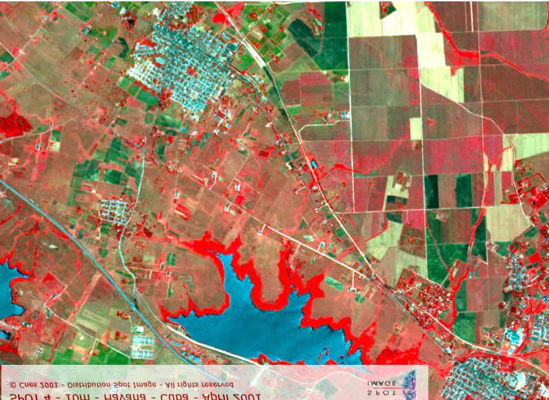
2 GIS in urban planning and management Geographic Information Systems (GIS) are widely used in the urban context replacing cadastres on paper helping to manage infrastructure organizing public transportation for citywide development plans
3
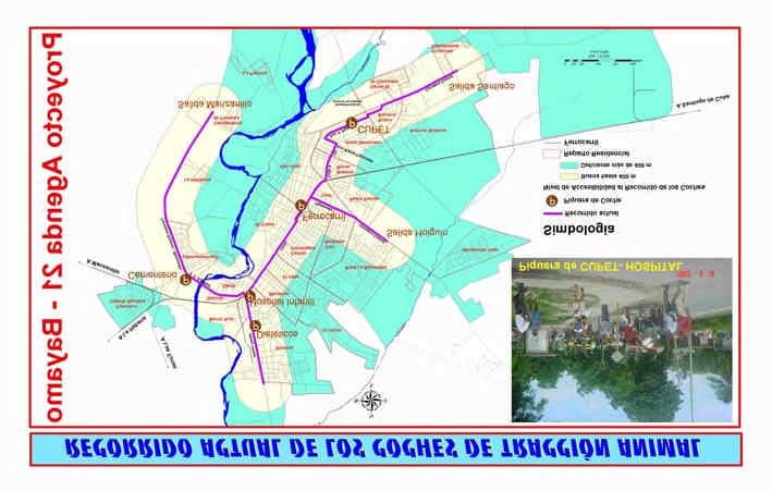
4 An Environmental Management Information System (EMIS) is a system for managing spatial, geographical information in the environmental planning and management Environmental resource systems: their sustainable yield and their vulnerability Development activities: their resource consumption and their potential impacts on environmental systems
5 EMIS... Principles of EMIS is a tool to support EPM is a constantly updated learning information system uses any available information sources, both scientific and non-scientific strictly separates facts from policies follows a consistent mapping rationale is accessible to the public, private, and popular sectors and is promoted through effective information outreach activities
6 EMIS in praxis EMIS as a tool for EPM was tested from 1997 onwards Handbook published in 2000 Now used in more than 20 cities worldwide In many different ways/ focus Main problem: how to make the system routine
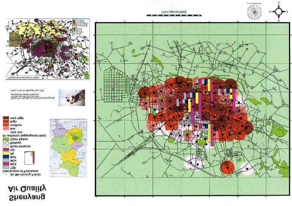
7 Shenyang,China: Air Quality Issue: managing air pollution in city, identification of polluters, identification of hot-spots Data: 6 air-quality indicators measured with mobile station Map: evaluation of data using policy rules, buffer tool to extrapolate point data to spatial
8
9 Nairobi, Kenya: River Pollution Issue: pollution of river basin through different urban activities Data: taking probes along the river measuring a number of indicators Map: interpretation of point data to identify degree of pollution, adding landuse to identify conflicts / hot spots

10 Map developed through investigation
11 Bayamo, Cuba: Urban Mobility Issue: identification of un-serviced areas Data: routes of horse-carts, population density Map: using buffer tool to identify areas within 10 minutes walking distance to the routes
12
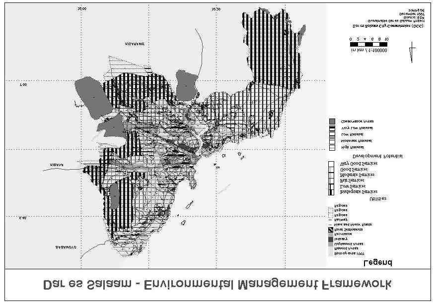
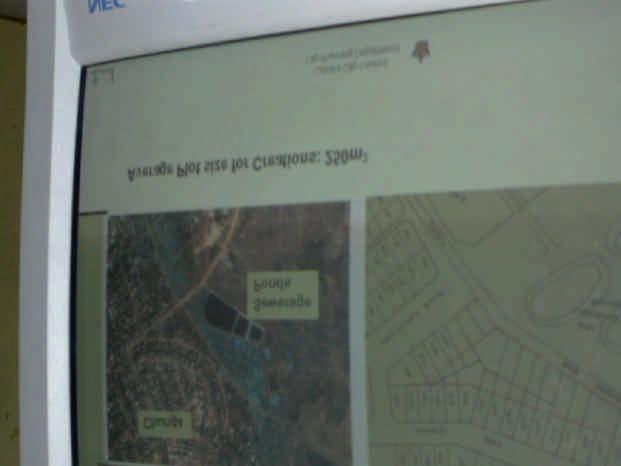
13 Dar es Salaam, Tanzania: SUDP Issue: managing city expansion, urban renewal, infrastructure => Strategic Urban Development Planning Framework Data: collected from 9 different working groups over 5 years Map: overlaying of various suitability and sensitivity maps
14 8. Development Pattern Dar es Salaam - Development Pattern BAGAMOYO KIBAHA Coast Region KISARAWE Indian Ocean Regions TYPE 1, 2, 3, 4, 5, 6 7, 8, 9, 10, 11, 12 13, 14, 15, 16, 17, 18 19, 20, 21, 22, 23, 24 25, 26, 27, 28, 29, 30 31, 32, 33, 34, 35, 36 37, 38, 39, 40, 41, 42 43, 44, 45, 46, 47, 48 49, 50, 51, 52, 53, 54 55, 56, 57, 58, 59, 60 61, 62, 63, 64, 65, 66 67, 68, 69, 70, 71, 72 73, 74, 75, 76, 77, 78 79, 80, 81, 82, 83, 84 85, 86, 87, 88, 89, 90 91, 92, 93, 94, 95, 96 97, 98, 99, 101, 102, , 105, 106, Legend Main and Minor Roads Railway in km / 1:n 2 10 Dar es Salaam City Commission (DCC) 6 E Sustainable Dar es Salaam Project (SDP) Source: xxx mo 1997 xy.prj Overlay maps with engineering constraints Overlaying maps with preservation constraints Rank constraints shown of the overall environmental constraint map Transform ranks of constraint into ranks of suitability
15
16 Dar es Salaam - Development Pattern BAGAMOYO KIBAHA Coast Region KISARAWE High environmental risks Good utility supply Land available Indian Ocean Regions Legend Main and Minor Roads Railway TYPE 1, 2, 3, 4, 5, 6 7, 8, 9, 10, 11, 12 High Low development environmental conflicts risks No utility supply Land available 13, 14, 15, 16, 17, 18 19, 20, 21, 22, 23, 24 25, 26, 27, 28, 29, 30 31, 32, 33, 34, 35, 36 37, 38, 39, 40, 41, 42 43, 44, 45, 46, 47, 48 49, 50, 51, 52, 53, 54 55, 56, 57, 58, 59, 60 61, 62, 63, 64, 65, 66 67, 68, 69, 70, 71, 72 73, 74, 75, 76, 77, 78 79, 80, 81, 82, 83, 84 85, 86, 87, 88, 89, 90 91, 92, 93, 94, 95, 96 97, 98, 99, 101, 102, , 105, 106, in km / 1:n E Dar es Salaam City Commission (DCC) Sustainable Dar es Salaam Project (SDP) Source: xxx mo 1997 xy.prj
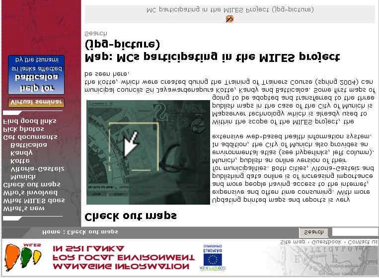
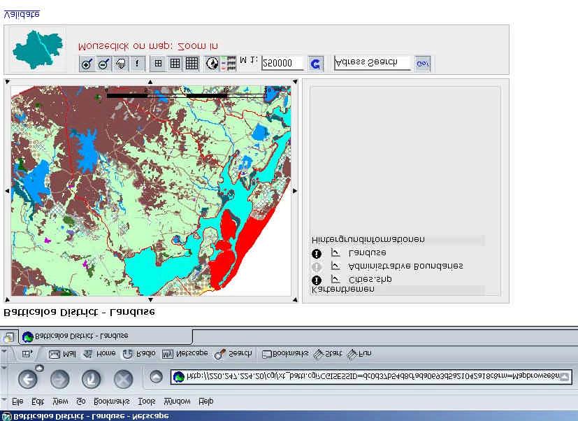
17 Sri Lanka, map server Issue: exchange of maps between different projects Data: developed in three municipalities by working groups Map server: accessibility of maps through the internet/ webserver
18
19
20 Lusaka, Zambia: transparent decisions Issue: transparency for decision makers in municipal council Data: detailed land information system on the basis of satellite images Map: every proposal contains a map with details about landownership and other relevant information about plots involved
21


22 EPM Implementation Process in 5 steps 3. Working groups 1. Environmental Profile 5. Consolidation & Institutionalisation 4. Strategy & Action plan 2. City Consultation
23 Information needs in EPM process 1. producing, storing, and updating environmental information for Environmental Profile 2. identify, clarify, and prioritise environmental issues through a geographically differentiated approach in City Consultation 3. formulate strategies and 4. develop action plans in working groups 5. monitoring and evaluation of achievements
24 Environmental Profile and EMIS EP gives systematic over-view of the city s environment setting, activity sectors and management system, Highlights environment-development interactions Information needs Spatial orientation Environmental setting Development activities Management system EMIS Prepare Basic Map & thematic maps on environmental and development issues Conduct inventory Store Data
25 City Consultation and EMIS The City Consultation is a high-profile city-wide conference to review, assess, and elaborate urban environmental issues and agree on priority issues and to bring together key actors ( stakeholders ). Information needs Spatial orientation Awareness raising Environmental issues EMIS Prepare exhibition with maps on environmental issues Distribute basic map
26 How Working Groups and EMIS interlink: Working Groups use Thematic maps to elaborate strategies identify the appropriate places for demonstration projects Working Groups provide information and maps through investigation Preparation of sensitivity/ suitability maps
27 Strategies and EMIS Strategies are long term visions, concerning goals and general directions. Action Plans are detailed (time, cost, actor), site specific, implementation plans. Information needs Development pattern Environmental setting Hot Spots Public awareness EMIS Analyse maps to develop strategy Analysemaps to identfy hotspots Provide maps explaining the strategy Prepare detailed action plans
 Source: xxx Sustainable Dar es Salaam mo Project 1997(SDP) Source: xy.")
 January 1998 Sustainable Dar es Salaam Project")

28 BAGAMOYO KIBAHA BAGAMOYO KIBAHA KISARAWE KISARAWE Seasonal Rivers & Seasonal Streams Seasonal Rivers & Seasonal Streams Main and Minor Roads Railway Main and Minor Roads Railway Sustainable Dar es Salaam Project (SDP) Source: xxx Sustainable Dar es Salaam mo Project 1997(SDP) Source: xy.prj xxx Sustainable Dar es Salaam Project (SDP) Source: xxx Sustainable Dar es Salaam Project mo 1997 (SDP) Source: xy.prj xxx BAGAMOYO KIBAHA BAGAMOYO KIBAHA KISARAWE KISARAWE Source: xxx Dar es Salaam City Commission (DCC) January 1998 Sustainable Dar es Salaam Project (SDP) uasuit.prj uasuit.prj 4 Basic Map Dar Dar es es Salaam Salaam Legend Legend 5 Thematic Maps Indian Indian Ocean Ocean Coast Coast Region Region 3 Inventory 2 in km / 1:n in km / 1:n 6 10 E Dar es Salaam City Commission (DCC) Dar es Salaam City Commission (DCC) mo 1997 xy.prj Building an EMIS Step-by-step 8 Outputs BAGAMOYO Dar Dar es es Salaam Salaam - - Development Development Pattern Pattern KIBAHA BAGAMOYO KIBAHA Coast Region Coast Region KISARAWE KISARAWE Indian Ocean Indian Ocean Legend Legend Regions Regions Main and Minor Roads Main and Minor Roads Railway Railway TYPE 1, 2, 3, TYPE 4, 5, 6 7, 8, 1, 9, 2, 10, 3, 4, 11, 5, , 14, 15, 16, 17, 18 7, 8, 9, 10, 11, 12 19, 13, 20, 14, 21, 15, 22, 16, 23, 17, , 26, 27, 28, 29, 30 19, 20, 21, 22, 23, 24 31, 25, 32, 26, 33, 27, 34, 28, 35, 29, , 31, 38, 32, 39, 33, 40, 34, 41, 35, , 44, 45, 46, 47, 48 37, 38, 39, 40, 41, 42 49, 43, 50, 44, 51, 45, 52, 46, 53, 47, , 49, 56, 50, 57, 51, 58, 52, 59, 53, , 62, 63, 64, 65, 66 55, 56, 57, 58, 59, 60 67, 61, 68, 62, 69, 63, 70, 64, 71, 65, , 67, 74, 68, 75, 69, 76, 70, 77, 71, , 80, 81, 82, 83, 84 73, 74, 75, 76, 77, 78 85, 79, 86, 80, 87, 81, 88, 82, 89, 83, , 92, 93, 94, 95, 96 85, 86, 87, 88, 89, 90 97, 91, 98, 92, 99, 93, 101, 94, 102, 95, , 97, 105, 98, 106, 99, 101, , , 105, 106, in 0km / 1:n 2 in km / 1:n E 10 Dar es Salaam City Commission (DCC) Dar es Salaam City Commission (DCC) mo 1997 xy.prj 6 Suitability / Sensitivity Maps Dar es Salaam - Suitability for Urban Agriculture Dar es Salaam - Suitability for Urban Agriculture Coast Region Coast Region Indian Indian Ocean Ocean 7 Overlays Legend Legend Highly Available Highly Available Moderately Available IIA Moderately Available IIA Less available Less available Not suitable Not suitable in km / 1:n 2 in 6 km 10 / 1:n E E Dar es Salaam City Commission (DCC) Sustainable Dar es Salaam Project (SDP) Source: xxx January 1998 Setting up the system: 1 Equipment 2 Mapping Group
29 How to maintain EMIS: EPM is all about change changing the ways in which people think about urban development and environment and changing the ways in which people and institutions behave Institutionalisation is about making those changes permanent, building them into habits, procedures and routines. EMIS needs continuous input to stay up to date supports the monitoring of the environment situation evaluates of the achievements of the EPM approach
30 Maintaining EMIS - problems qualified personnel funds for maintaining/ updating hard ware and software funds for purchasing data, satellite images using EMIS in day to day practice linking EMIS/ technical approach with participatory process
31 Thank you for your attention! Urban Environment Section/SCP, UN-HABITAT, P.O.Box 30030, Nairobi KENYA. TEL: , FAX: scp@unhabitat.org
Local EPM Implementation Process in 5 stages
 Local PM Implementation Process in 5 stages 3. Working groups 1. City nvironmental Profile/ Outlook 5. Consolidation & Institutionalisation 4. Strategy & Action plans 2. City Consultation Urban nvironmental
The opinions expressed in this document are those of the authors and not necessarily those of the United Nations
 Copyright: The United Nations Centre for Human Settlements (UNCHS Habitat) and the United Nations Environment Programme (UNEP), December 2000 UNCHS: P.O. Box 30030, Nairobi, Kenya UNEP: P.O. Box 30552,
Dar es Salaam - Reality Check Workshop
 Dar es Salaam - Reality Check Workshop hosted by GIZ and Dar es Salaam City Council Introduction: Key Urban Characteristics of Dar es Salaam Challenges and Opportunities for Resilient Development in the
Aboriginal communities strengthen governance with location-based tools in the 21st century
 Aboriginal communities strengthen governance with location-based tools in the 21st century Today, Aboriginal communities are taking advantage of the geomatics technologies that underpin popular online
Land Use in the context of sustainable, smart and inclusive growth
 Land Use in the context of sustainable, smart and inclusive growth François Salgé Ministry of sustainable development France facilitator EUROGI vice president AFIGéO board member 1 Introduction e-content+
RETA 6422: Mainstreaming Environment for Poverty Reduction Category 2 Subproject
 RETA 6422: Mainstreaming Environment for Poverty Reduction Category 2 Subproject A. Basic Data 1. Subproject Title: Poverty-Environment Mapping to Support Decision Making 2. Country Director: Adrian Ruthenberg
Georeferencing and Satellite Image Support: Lessons learned, Challenges and Opportunities
 Georeferencing and Satellite Image Support: Lessons learned, Challenges and Opportunities Shirish Ravan shirish.ravan@unoosa.org UN-SPIDER United Nations Office for Outer Space Affairs (UNOOSA) UN-SPIDER
Realizing benefits of Spatial Data Infrastructure A user s perspective from Environment Agency - Abu Dhabi
 Realizing benefits of Spatial Data Infrastructure A user s perspective from Environment Agency - Abu Dhabi Anil Kumar Director, Environment Information Management 26 April 2012 Geospatial World Forum,
Spatial decision making in Armenia based on multidisciplinary environmental research
 EU FP7 EcoArm2ERA Integration into ERA Integration of spatial decision support systems and evidence based modeling in National/Regional Policy applications and regulatory systems: scientific and policy
NSDI as a tool for Secure land tenure
 NSDI as a tool for Secure land tenure General Overview To look at the progress in SDI development and its application in policy formulation and impact on land tenure. INTEGRATION OF INFORMATION POLICIES
CAMP SLOVENIA. Mezek Slavko RRC Koper. Project coordinator November 2005
 CAMP SLOVENIA Mezek Slavko RRC Koper Project coordinator November 2005 http://camp.rrc-kp.si/ Content About MAP CAMP programme CAMP Slovenia Project background CAMP Slovenia Project area CAMP Slovenia
ACTION PLAN FOR WORLD HERITAGE IN LATIN AMERICA AND THE CARIBBEAN ( )
") Annex ACTION PLAN FOR WORLD HERITAGE IN LATIN AMERICA AND THE CARIBBEAN (2014-2024) The current Regional Action Plan for Latin America and the Caribbean for 2014-2024 has been elaborated by the State Parties
Annex ACTION PLAN FOR WORLD HERITAGE IN LATIN AMERICA AND THE CARIBBEAN (2014-2024) The current Regional Action Plan for Latin America and the Caribbean for 2014-2024 has been elaborated by the State Parties
Use of Geospatial data for disaster managements
 Use of Geospatial data for disaster managements Source: http://alertsystemsgroup.com Instructor : Professor Dr. Yuji Murayama Teaching Assistant : Manjula Ranagalage What is GIS? A powerful set of tools
National Land Use Policy and National Integrated Planning Framework for Land Resource Development
 Title National Land Use Policy and National Integrated Planning Framework for Land Resource Development Duration: 32 Weeks Objective: Adoption of appropriate land use planning approaches to: Maintain the
Urban Spatial Scenario Design Modelling (USSDM) in Dar es Salaam: Background Information
 in Dar es Salaam: Background Information") Urban Spatial Scenario Design Modelling (USSDM) in Dar es Salaam: Background Information Modelling urban settlement dynamics in Dar es Salaam Revision: 2 (July 2013) Prepared by: Katja Buchta TUM team
Urban Spatial Scenario Design Modelling (USSDM) in Dar es Salaam: Background Information Modelling urban settlement dynamics in Dar es Salaam Revision: 2 (July 2013) Prepared by: Katja Buchta TUM team
Land Administration and Cadastre
 Geomatics play a major role in hydropower, land and water resources and other infrastructure projects. Lahmeyer International s (LI) worldwide projects require a wide range of approaches to the integration
Urban Climate Resilience
 Urban Climate Resilience in Southeast Asia Partnership Project Introduction Planning for climate change is a daunting challenge for governments in the Mekong Region. Limited capacity at the municipal level,
International Guidelines on Access to Basic Services for All
 International Guidelines on Access to Basic Services for All Presentation and initials lessons from implementation Accessibility to services in regions and cities : measures and policies, OECD 18 June
SPLAN-Natura Towards an integrated spatial planning approach for Natura th January, 2017 Brussels. Commissioned by DG Environment
 SPLAN-Natura 2000 Towards an integrated spatial planning approach for Natura 2000 Commissioned by DG Environment 17 th January, 2017 Brussels V. Simeonova (Ph.D.) Drivers towards integrating Biodiversity
GIS Geographical Information Systems. GIS Management
 GIS Geographical Information Systems GIS Management Difficulties on establishing a GIS Funding GIS Determining Project Standards Data Gathering Map Development Recruiting GIS Professionals Educating Staff
Key Indicators for Territorial Cohesion & Spatial Planning Stakeholder Workshop - Project Update. 13 th December 2012 San Sebastián, Basque Country
 Key Indicators for Territorial Cohesion & Spatial Planning Stakeholder Workshop - Project Update 13 th December 2012 San Sebastián, Basque Country Key Aims Explore the use of territorial data in developing
ACTION PLAN FOR WORLD HERITAGE IN LATIN AMERICA AND THE CARIBBEAN
 Final version-to send to the ACTION PLAN FOR WORLD HERITAGE IN LATIN AMERICA AND THE CARIBBEAN 2014-2024 The current Regional Action Plan for Latin America and the Caribbean has been elaborated by the
GIS in Community & Regional Planning
 GIS in Community & Regional Planning The The role role of of GIS GIS in in Re-writing the the Zoning Bylaw for for the the City City of of Vernon LandInfo Technologies Presentation Overview The GIS Initiative
Systems (GIS) - with a focus on.
 - with a focus on.") Introduction to Geographic Information Systems (GIS) - with a focus on localizing the MDGs Carmelle J. Terborgh, Ph.D. ESRI www.esri.com Flying Blind Jul 24th 2003 The Economist We Live in Two Worlds Natural
Introduction to Geographic Information Systems (GIS) - with a focus on localizing the MDGs Carmelle J. Terborgh, Ph.D. ESRI www.esri.com Flying Blind Jul 24th 2003 The Economist We Live in Two Worlds Natural
AFRICAN URBANIZATION: SOME KEY ISSUES. Patricia Jones University of Oxford IGC Conference, Dar es Salaam 25 th February 2015
 AFRICAN URBANIZATION: SOME KEY ISSUES Patricia Jones University of Oxford IGC Conference, Dar es Salaam 25 th February 2015 Introduction New project on urbanization in Africa. World Bank funded but independent
Geographical Information Systems Energy Database Report. WP1 T1.3- Deliverable 1.9
 Geographical Information Systems Energy Database Report WP1 T1.3- Deliverable 1.9 March 2015 1 314164 (ENER/FP7/314164) Project acronym: InSMART Project full title: Integrative Smart City Planning Coordination
HELSINKI COMMISSION Baltic Marine Environment Protection Commission
 HELSINKI COMMISSION Baltic Marine Environment Protection Commission HELCOM RECOMMENDATION 24/10 Adopted 25 June 2003, having regard to Article 20, Paragraph 1 b) of the 1992 Helsinki Convention IMPLEMENTATION
The Global Fundamental Geospatial Data Themes Journey. April Clare Hadley WG Chair
 The Global Fundamental Geospatial Data Themes Journey April 2018 Clare Hadley WG Chair The Road to here Why Global? Why Geospatial? Why Fundamental? Why Themes? The route we took Where does the road go
Proposal for a DIRECTIVE OF THE EUROPEAN PARLIAMENT AND OF THE COUNCIL. establishing an infrastructure for spatial information in the Community
 Proposal for a DIRECTIVE OF THE EUROPEAN PARLIAMENT AND OF THE COUNCIL establishing an infrastructure for spatial information in the Community INSPIRE http://inspire.jrc.it/ Alessandro Annoni 1 EU Commission
TERRITORIAL IMPACT ASSESSMENT: AN APPROACH TO IMPROVE THE VERTICAL AND HORIZONTAL INTEGRATION OF EU POLICIES
 TERRITORIAL IMPACT ASSESSMENT: AN APPROACH TO IMPROVE THE VERTICAL AND HORIZONTAL INTEGRATION OF EU POLICIES Naja Marot & Mojca Golobič Biotehnical Faculty, University of Ljubljana, Slovenia RSA Workshop
Introduction and Project Overview
 Greater New Orleans Regional Land Use Modeling GIS Techniques in a P olitical C ontext Louisiana Remote Sensing and GIS Workshop Wednesday, April 24, 2013 Working Towards a Shared Regional Vision Introduction
Disaster Management & Recovery Framework: The Surveyors Response
 Disaster Management & Recovery Framework: The Surveyors Response Greg Scott Inter-Regional Advisor Global Geospatial Information Management United Nations Statistics Division Department of Economic and
Urban Planning for Climate Change
 Urban Planning for Climate Change FIG Working Group 8.1 Frank Friesecke, Sophie Schetke, Theo Kötter AGENDA 1. Introduction 2. Urbanisation and Climate Change 3. Need of the Surveying Profession in Dealing
Sistema de Informacion Geografica Peninsular de Yucatan (SIGPY): WORK PLAN for the UQROO- URI GIS Development Project
: WORK PLAN for the UQROO- URI GIS Development Project") Sistema de Informacion Geografica Peninsular de Yucatan (SIGPY): WORK PLAN for the UQROO- URI GIS Development Project Eddie Ellis, UQROO 2001 Citation: Quintana Roo, Mexico: Universidad de Quintana Roo
Sistema de Informacion Geografica Peninsular de Yucatan (SIGPY): WORK PLAN for the UQROO- URI GIS Development Project Eddie Ellis, UQROO 2001 Citation: Quintana Roo, Mexico: Universidad de Quintana Roo
Economic and Social Council
 United Nations Economic and Social Council Distr.: General 2 July 2012 E/C.20/2012/10/Add.1 Original: English Committee of Experts on Global Geospatial Information Management Second session New York, 13-15
COUNCIL OF THE EUROPEAN UNION. Brussels, 2 May /14 CULT 68
 COUNCIL OF THE EUROPEAN UNION Brussels, 2 May 2014 9129/14 CULT 68 NOTE from: General Secretariat of the Council to: Permanent Representatives Committee (Part 1) / Council No. prev. doc.: 8892/14 CULT
2 nd Semester. Core Courses. C 2.1 City and Metropolitan Planning. Module 1: Urban Structure and Growth Implications
 2 nd Semester Core Courses C 2.1 City and Metropolitan Planning Module 1: Urban Structure and Growth Implications Growth of cities; cities as engine of growth; urban sprawl; land value, economic attributes
GEOMATICS. Shaping our world. A company of
 GEOMATICS Shaping our world A company of OUR EXPERTISE Geomatics Geomatics plays a mayor role in hydropower, land and water resources, urban development, transport & mobility, renewable energy, and infrastructure
A Method for Mapping Settlement Area Boundaries in the Greater Golden Horseshoe
 A Method for Mapping Settlement Area Boundaries in the Greater Golden Horseshoe Purpose This paper describes a method for mapping and measuring the lands designated for growth and urban expansion in the
Towards Reliable Spatial Database of Informal Areas in Greater Cairo Region
 KEYWORDS informal areas, unreliable spatial data, spatial data collecting, capacity building SUMMARY The uncontrolled and rapid increase of Egypt s cities is a major problem of the country. More than the
Report on the establishment of UN GGIM: Europe Item 14. 4th session of the Committee of Experts on UN-GGIM
 Report on the establishment of UN GGIM: Europe Item 14 1 Why regional European committees of UN GGIM? In the ECOSOC resolution 2011/24 on the UN GGIM: Emphasizes the importance of promoting national, regional
UNITED NATIONS E/CONF.96/CRP. 5
 UNITED NATIONS E/CONF.96/CRP. 5 ECONOMIC AND SOCIAL COUNCIL Eighth United Nations Regional Cartographic Conference for the Americas New York, 27 June -1 July 2005 Item 5 of the provisional agenda* COUNTRY
Together towards a Sustainable Urban Agenda
 Together towards a Sustainable Urban Agenda The City We (Youth) Want Preliminary findings from youth consultations Areas Issue Papers Policy Units 1.Social Cohesion and Equity - Livable Cities 2.Urban
2018/1 The integration of statistical and geospatial information. The Regional Committee of UN-GGIM: Americas:
 The following are the conclusions and recommendations of the Regional Committee of the United Nations on Global Geospatial Information Management for the Americas, during its Fifth Session, Thursday 8
A science-policy approach towards local adaptation planning: The case of Santiago de Chile
 A science-policy approach towards local adaptation planning: The case of Santiago de Chile Kerstin Krellenberg, PhD Resilient Cities 2011 2nd World Congress on Cities and Adaptation to Climate Change Bonn,
Techniques for Science Teachers: Using GIS in Science Classrooms.
 Techniques for Science Teachers: Using GIS in Science Classrooms. After ESRI, 2008 GIS A Geographic Information System A collection of computer hardware, software, and geographic data used together for
16540/14 EE/cm 1 DG E 1A
 Council of the European Union Brussels, 5 December 2014 (OR. en) 16540/14 ENV 965 CULT 139 NOTE From: To: Subject: General Secretariat of the Council Delegations Charter of Rome on Natural and Cultural
GIS, Maps and Spatial Analyses in Urban Planning
 GIS, Maps and Spatial Analyses in Urban Planning LOOM.02.331 ANTO AASA PhD, researcher Power of visualization: What s this? Economic spaces in Europe (chorems based approach) Europe economy 1646 General:
National Public Weather and Warning Services in the Swaziland Meteorological Service Dennis S.Mkhonta /
 National Public Weather and Warning Services in the Swaziland Meteorological Service Dennis S.Mkhonta dennis.mkhonta@gmail.com / dennis@swazimet.gov.sz Introduction Swaziland s geographical position exposes
Implementation of the ESPON 2020 cooperation program. 16 January 2017 Anneloes van Noordt
 Implementation of the ESPON 2020 cooperation program 16 January 2017 Anneloes van Noordt Outline! ESPON Cooperation Program! Specific Objectives! Applied Research! Targeted Analysis! Database & Tools!
Contents: LEVANTE DE ALMERÍA A INFORMATION SYSTEM OBJECTIVES AND ACTIONS GEOGRAPHIC INFORMATION SYSTEM RESULTS
 Contents: LEGAL FRAMEWORK: BARCELONA CONVENTION AND ICZM PROTOCOL; COASTAL AREAS MANAGEMENT PROGRAMME; CAMP LEVANTE DE ALMERIA; OVERALL AIM AND KEY IDEAS AREA PHASES PROJECT STRUCTURE ACTIVITIES INSTITUTIONAL
Application of Geographic Information Systems for Government School Sites Selection
 Rs. 3000,00 Application of Geographic Information Systems for Government School Sites Selection by K. D. Nethsiri Jayaweera M.Sc. Library - USJP 1111111111111111 210975 2014 210873 Application of Geographic
City and SUMP of Ravenna
 City and SUMP of Ravenna Nicola Scanferla Head of Mobility Planning Unit, Municipality of Ravenna nscanferla@comune.ra.it place your logo here 19 April, 2017 1st Steering Committee Meeting, Nicosia, Cyprus
The Governance of Land Use
 The planning system Levels of government and their responsibilities The Governance of Land Use COUNTRY FACT SHEET NORWAY Norway is a unitary state with three levels of government; the national level, 19
COASTAL MANAGEMENT IN TANZANIA
 COASTAL MANAGEMENT IN TANZANIA Presented by: Ms. Flora D. Akwilapo UN-NF ALUMNI MEETING NAIROBI 11-15 JULY 2011 THE COASTAL AREA OF TANZANIA The coastal area of Tanzania encompasses Five Regions of Tanga,
Marine Spatial Planning as an important tool for implementing the MSFD
 Marine Spatial Planning as an important tool for implementing the MSFD Risto Kalliola Tallinn, Nov. 16 th 2012 DEPARTMENT OF GEOGRAPHY AND GEOLOGY University of Turku, Finland Ten principles to provide
The Governance of Land Use
 The Governance of Land Use Country fact sheet Czech Republic The planning system Levels of government and their responsibilities The Czech Republic is a unitary state with 3 levels of government: the national
The UN-GGIM: Europe core data initiative to encourage Geographic information supporting Sustainable Development Goals Dominique Laurent, France
 INSPIRE conference Strasbourg 6 September 2017 The UN-GGIM: Europe core data initiative to encourage Geographic information supporting Sustainable Development Goals Dominique Laurent, France Introduction
Spatial Analysis and Modeling of Urban Land Use Changes in Lusaka, Zambia: A Case Study of a Rapidly Urbanizing Sub- Saharan African City
 Spatial Analysis and Modeling of Urban Land Use Changes in Lusaka, Zambia: A Case Study of a Rapidly Urbanizing Sub- Saharan African City January 2018 Matamyo SIMWANDA Spatial Analysis and Modeling of
Building Institutional Capacity for Multi-Hazard Early Warning in Asia and the Pacific Subtitle
 Building Institutional Capacity for Multi-Hazard Early Warning in Asia and the Pacific Subtitle Title Keran Wang Chief, Space Applications Section ICT and Disaster Risk Reduction Division 22 May 2018 Pillar
Jordan's Strategic Research Agenda in cultural heritage
 Jordan's Strategic Research Agenda in cultural heritage Analysis of main results Alessandra Gandini Amman, Jordan 3 rd November 2013 Main objectives The work performed had the main objective of giving
Public Participatory GIS (ppgis), training & webgis in Mare Nostrum. Anna Spiteri, IRMCo Haifa, Israel, 5th March 2013
, training & webgis in Mare Nostrum. Anna Spiteri, IRMCo Haifa, Israel, 5th March 2013") Public Participatory GIS (ppgis), training & webgis in Mare Nostrum Anna Spiteri, IRMCo Haifa, Israel, 5th March 2013 What is ppgis? Why do we need it? Who participates? Where do we do it? When do we do
Public Participatory GIS (ppgis), training & webgis in Mare Nostrum Anna Spiteri, IRMCo Haifa, Israel, 5th March 2013 What is ppgis? Why do we need it? Who participates? Where do we do it? When do we do
INSPIRE Basics. Vlado Cetl European Commission Joint Research Centre. https://ec.europa.eu/jrc/
 INSPIRE Basics Vlado Cetl European Commission Joint Research Centre https://ec.europa.eu/jrc/ Serving society Stimulating innovation Supporting legislation Outline SDI? Why European SDI? INSPIRE Policy
TP4D. Fostering territorial perspective for development. Towards a wider alliance
 Fostering territorial perspective for development Towards a wider alliance FOR several years, territorial approaches to development have been spreading within international organizations and among development
INDONESIA S S UPDATE: GEOSPATIAL INFORMATION FOR SUSTAINABLE DEVELOPMENT RELATED TO INA SDI Dr. Asep Karsidi, M.Sc
 INDONESIA S S UPDATE: GEOSPATIAL INFORMATION FOR SUSTAINABLE DEVELOPMENT RELATED TO INA SDI Dr. Asep Karsidi, M.Sc GEOSPATIAL INFORMATION AGENCY 08 August, 2012 OUTLINE 1. Transformation Bakosurtanal into
March 2007 The Survey Department of Sri Lanka
 Contribution of Survey Department of Sri Lanka for Mitigation of Disasters in Sri Lanka K.A.U.N.Kasthuri Deputy Surveyor General (Information Technology) March 2007 The Survey Department of Sri Lanka 1
The Added Value of Geospatial Data in a Statistical Office. Pedro Diaz Munoz Director Sectoral and Regional Statistics EUROSTAT European Commission
 The Added Value of Geospatial Data in a Statistical Office Pedro Diaz Munoz Director Sectoral and Regional Statistics EUROSTAT European Commission Why integrate Responsibility of all the information we
BURGAS CASE STUDY: LAND-SEA INTERACTIONS. Dr. Margarita Stancheva
 BURGAS CASE STUDY: LAND-SEA INTERACTIONS Dr. Margarita Stancheva Name of presentation NEED FOR COHERENCE BETWEEN LAND AND SEA ACTIVITIES Name presenter Burgas is the fourth largest city in Bulgaria and
NSDI Policy Framework of Japan - Roles of the Private Sector in SDI -
 NSDI Policy Framework of Japan - Roles of the Private Sector in SDI - Hiroshi Murakami (GSI) Geospatial World Forum 2012 Amsterdam Background Survey Act (1949) mandates the (GSI) to develop and provide
Sustainable tourism in for Sustaibale Danang
 Sustainable tourism in for Sustaibale Danang A case study of Balearic Ecotax in Spain toward Sustainable tourism Miki Yoshizumi Associate Professor College of Gastronomy Management Ritsumeikan University
CHAPTER 4 HIGH LEVEL SPATIAL DEVELOPMENT FRAMEWORK (SDF) Page 95
 Page 95") CHAPTER 4 HIGH LEVEL SPATIAL DEVELOPMENT FRAMEWORK (SDF) Page 95 CHAPTER 4 HIGH LEVEL SPATIAL DEVELOPMENT FRAMEWORK 4.1 INTRODUCTION This chapter provides a high level overview of George Municipality s
CHAPTER 4 HIGH LEVEL SPATIAL DEVELOPMENT FRAMEWORK (SDF) Page 95 CHAPTER 4 HIGH LEVEL SPATIAL DEVELOPMENT FRAMEWORK 4.1 INTRODUCTION This chapter provides a high level overview of George Municipality s
Applying Hazard Maps to Urban Planning
 Applying Hazard Maps to Urban Planning September 10th, 2014 SAKAI Yuko Disaster Management Expert JICA Study Team for the Metro Cebu Roadmap Study on the Sustainable Urban Development 1 Contents 1. Outline
Future Visions and Urban Development in Dar es Salaam
 Future Visions and Urban Development in Dar es Salaam There is a building boom in Dar es Salaam. Some of the new skyscrapers include hotels and offices. But most of the space is flats, for example in these
Declaration Population and culture
 Declaration Population and culture The ministers of the parties to the Alpine Convention regard the socio-economic and socio-cultural aspects mentioned in Article 2, Paragraph 2, Item a., as being central
DETERMINE OF REGIONAL DEVELOPMENT STRATEGIES IN IZMIR
 Sukran Yalpir Asli Bozdag Saban Inam DETERMINE OF REGIONAL DEVELOPMENT STRATEGIES IN IZMIR Globalization INTRODUCTION Economic pressure cause Economic migration cause cause Spatial organizations Spatial
TOWARDS STRATEGIC SPATIAL PLANNING IN JAMAICA: THE NATIONAL SPATIAL PLAN
 TOWARDS STRATEGIC SPATIAL PLANNING IN JAMAICA: THE NATIONAL SPATIAL PLAN JIEP 5th Biennial Conference on the Environment: Balancing National Development and Environmental Protection June 6, 2011 Jamaica
MR. George ALEXAKIS, parallel session 3. "Mediterranean Sea Region. laying the conditions. for sustainable growth and jobs"
 parallel session 3 "Mediterranean Sea Region laying the conditions for sustainable growth and jobs" MR. George ALEXAKIS, elected Regional Councillor of Crete, Greece and representative of Crete in CRPM.
RCOF Review [Regional Climate Outlook Forum for the Gulf of Guinea region of Africa - PRESAGG] Status Report
![RCOF Review [Regional Climate Outlook Forum for the Gulf of Guinea region of Africa - PRESAGG] Status Report](/thumbs/78/77466191.jpg "RCOF Review [Regional Climate Outlook Forum for the Gulf of Guinea region of Africa - PRESAGG] Status Report") RCOF Review 2017 [Regional Climate Outlook Forum for the Gulf of Guinea region of Africa - PRESAGG] Status Report Specific Climate features of concerned region This region typically covers the area below
RCOF Review 2017 [Regional Climate Outlook Forum for the Gulf of Guinea region of Africa - PRESAGG] Status Report Specific Climate features of concerned region This region typically covers the area below
Urbanization and Sustainable Development of Cities: A Ready Engine to Promote Economic Growth and Cooperation
 Urbanization and Sustainable Development of Cities: A Ready Engine to Promote Economic Growth and Cooperation Wan Portia Hamzah Institute of Strategic and International Studies (ISIS) Malaysia 10 September
Margarita Stancheva Hristo Stanchev & Robert Young 2. MEDCOAST JUBILEE WORKSHOP May 2015, Iberotel Sarigerme Park, Dalaman, Turkey
 Margarita Stancheva Hristo Stanchev & Robert Young 2 INTRODUCTION: Bulgarian Black Sea coast INTRODUCTION: Increasing pressure on Bulgarian coastal zone In 2011, of the 7 364 570 people that lived in Bulgaria,
Assessment of Sustainable Land Use within the Town Planning Process Experiences with a Multi Criteria Approach (MCA)
") Assessment of Sustainable Land Use within the Town Planning Process Experiences with a Multi Criteria Approach (MCA) Dipl.-Geogr. Sophie Schetke Dipl.-Ing. Benedikt Frielinghaus, University of Bonn, Germany
Assessment of Sustainable Land Use within the Town Planning Process Experiences with a Multi Criteria Approach (MCA) Dipl.-Geogr. Sophie Schetke Dipl.-Ing. Benedikt Frielinghaus, University of Bonn, Germany
GIS Data and Technology to Support Transportation & MPO Decision-Making & Planning. using an Eco-Logical* Approach within the Kansas City Region
 GIS Data and Technology to Support Transportation & MPO Decision-Making & Planning using an Eco-Logical* Approach within the Kansas City Region Authors (in alphabetical order): Tom Gerend, Tom Jacobs,
Land Use of the Geographical Information System (GIS) and Mathematical Models in Planning Urban Parks & Green Spaces
 and Mathematical Models in Planning Urban Parks & Green Spaces") Land Use of the Geographical Information System (GIS) and Mathematical Models in Planning Urban Key words: SUMMARY TS 37 Spatial Development Infrastructure Linkages with Urban Planning and Infrastructure
Land Use of the Geographical Information System (GIS) and Mathematical Models in Planning Urban Key words: SUMMARY TS 37 Spatial Development Infrastructure Linkages with Urban Planning and Infrastructure
Implementing the Sustainable Development Goals: The Role of Geospatial Technology and Innovation
 Fifth High Level Forum on UN Global Geospatial Information Management Implementing the Sustainable Development Goals: The Role of Geospatial Technology and Innovation 28-30 November 2017 Sheraton Maria
Study Visit University of Applied Sciences Utrecht Netherlands
 Study Visit University of Applied Sciences Utrecht Netherlands Directorate-General for Territorial Development Lisbon 1 April 2014 1 Agenda Presentation Cadastre Department Surveying / Geodesy Department
Current experiences in the use of satellite information in development aid activities
 Current experiences in the use of satellite information in development aid activities Meeting at ESA/ESRIN in Frascati 16 th of September 2017 #WorldInCommon AGENCE FRANÇAISE DE DÉVELOPPEMENT FRENCH DEVELOPMENT
Reducing Vulnerability to Extreme Heat: Science-Policy Interface
 Reducing Vulnerability to Extreme Heat: Science-Policy Interface Olga Wilhelmi, Mary Hayden, Jennifer Boehnert, Ursula Lauper and SIMMER research team October 23, 2013 Toronto SIMMER workshop Science-Policy
Doug Kluck NOAA Kansas City, MO National Center for Environmental Information (NCEI) National Integrated Drought Information System (NIDIS)
 National Integrated Drought Information System (NIDIS)") National Integrated Drought Information System (NIDIS) for the Missouri River Basin Drought Early Warning Information System (DEWS) & Runoff Trends in the Missouri Basin & Latest Flood Outlook Doug Kluck
National Integrated Drought Information System (NIDIS) for the Missouri River Basin Drought Early Warning Information System (DEWS) & Runoff Trends in the Missouri Basin & Latest Flood Outlook Doug Kluck
THE ROLE OF GEOSPATIAL AT THE WORLD BANK
 THE ROLE OF GEOSPATIAL AT THE WORLD BANK INSPIRE Conference Barcelona, Spain September 26, 2016 Kathrine Kelm Senior Land Administration Specialist Global Land and Geospatial Unit The World Bank Group
Future perspectives for EO in Development
 Future perspectives for EO in Development Meeting at ESA/ESRIN in Frascati 11 th of September 2018 #WorldInCommon AGENCE FRANÇAISE DE DÉVELOPPEMENT FRENCH DEVELOPMENT AGENCY 01. What is AFD? France s international
Cercle Indicateurs. Sustainable Indicators at regional level. Jean-Blaise Trivelli, ARE Prague, Sustainability Indicators
 Bundesamt für Raumentwicklung ARE Office fédéral du développement territorial ARE Ufficio federale dello sviluppo territoriale ARE Uffizi federal da svilup dal territori ARE Cercle Indicateurs Sustainable
Eyes in the Sky & Data Analysis.
 Eyes in the Sky & Data Analysis How can we collect Information about Earth Climbing up Trees & Mountains Gathering Food Self Protection Understanding Surroundings By Travelling Collected Information Converted
transportation research in policy making for addressing mobility problems, infrastructure and functionality issues in urban areas. This study explored
 ABSTRACT: Demand supply system are the three core clusters of transportation research in policy making for addressing mobility problems, infrastructure and functionality issues in urban areas. This study
Bridging the Gap between Engineering and GIS
 Bridging the Gap between Engineering and GIS Presented by: Karen Stewart, B.Tech, GISP Manager of Geomatics Township of Langley February 13, 2006 Agenda Introduction History Goals Implementation Benefits
Regional Plan 4: Integrating Ecosystem Services Mapping into Regional Land Use Planning
 Rural-Urban Outlooks: Unlocking Synergies (ROBUST) ROBUST receives funding from the European Union s Horizon 2020 research and innovation programme under grant agreement No 727988.* October 2018 Natural
Cities and Climate Change (P123201)
") Public Disclosure Authorized AFRICA Mozambique Social, Urban, Rural and Resilience Global Practice Global Practice IBRD/IDA Investment Project Financing FY 2012 Seq No: 14 ARCHIVED on 04-Nov-2018 ISR33750
Public Disclosure Authorized AFRICA Mozambique Social, Urban, Rural and Resilience Global Practice Global Practice IBRD/IDA Investment Project Financing FY 2012 Seq No: 14 ARCHIVED on 04-Nov-2018 ISR33750
Exploring GIS Potential for Northwestern Ontario Land Information Ontario
 Exploring GIS Potential for Northwestern Ontario Land Information Ontario May 13, 2015 The LIO Vision LIO Vision: That all geographic information about Ontario is fully integrated and accessible LIO Goal:
Site Suitability Analysis for Local Airport Using Geographic Information System
 Cloud Publications International Journal of Advanced Remote Sensing and GIS 2018, Volume 7, Issue 1, pp. 2719-2727 ISSN 2320 0243, Crossref: 10.23953/cloud.ijarsg.368 Research Article Site Suitability
OVERVIEW OF THE PROGRESS IN IMPLEMENTING ALMATY PROGRAMME OF ACTION
 OVERVIEW OF THE PROGRESS IN IMPLEMENTING ALMATY PROGRAMME OF ACTION Thematic Meeting on International Trade, Trade Facilitation, and Aid for Trade, 13-14 September 2012, Almaty, Kazakhstan Sandagdorj Erdenebileg
Concept note. High-Level Seminar: Accelerating Sustainable Energy for All in Landlocked Developing Countries through Innovative Partnerships
 Concept note High-Level Seminar: Accelerating Sustainable Energy for All in Landlocked Developing Countries through Innovative Partnerships Date: 24 and 25 October 2016 Venue: Conference Room C3, Vienna