Biogeographic Assessments to Meet Local & Regional Management Needs
|
|
|
- Beverly Nicholson
- 5 years ago
- Views:
Transcription


1 Biogeographic Assessments to Meet Local & Regional Management Needs August 2012 / NCCOS / Center for Coastal Monitoring and Assessment Center for Coastal Fisheries and Habitat Research Chris Jeffrey Chris.Jeffrey@noaa.gov
2 Presentation Outline Overview of the Biogeographic Assessment Approach and Process Overview of the Florida Coral Reef Tract Biogeographic Assessment


3 Combine Biogeographic Layers for Analysis Analytical Products to Meet Management Objectives The Biogeographic Assessment Approach Biogeographic Data Layers Example Integrated Biogeographic Analyses* * Specific analyses targeted to management needs Products to Aid Management Imagery Defining and analyzing existing conditions Patterns of Human Use Bottom Type Species Richness Defining and analyzing future conditions Bathymetry Oceanography Species Distributions (many layers) Threatened Habitats Evaluate alternative management strategies (e.g. zoning)
4 Overview of the Assessment Process 1. Identify relevant management issues and questions Clients FKNMS Management (NOAA & FWC) Project Team
5 Overview of the Assessment Process 2. Data compilation and review Project Team Partners Providers of DATA SETS & Information
6 Overview of the Assessment Process 3. Data Integration & analysis Project Team Clients FKNMS Management (NOAA & FWC) Review Partners Providers of DATA SETS & Information
7 Overview of the Assessment Process 4. Product creation, roll-out, dissemination, and support Project Team Clients FKNMS Management (NOAA & FWC) Partners Providers of DATA SETS & Information

8 Biogeographic Assessments of National Marine Sanctuaries
9 SELECTED EXAMPLES OF BIOGEOGRAPHIC ASSESSMENTS & PRODUCTS

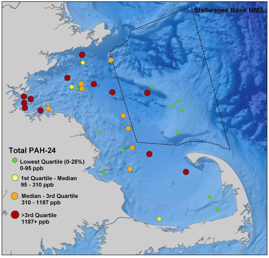
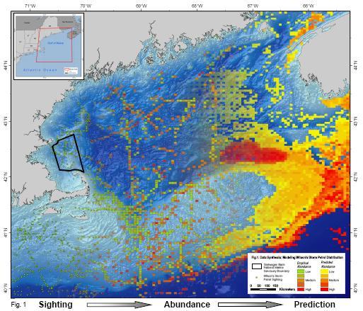
10 Assessment: Stellwagen Bank, MA Objective: To synthesize and integrate ecological data to support management plan review process. To provide spatial models of resource distribution to inform MA Ocean Plan. Balancing needs of shipping community and conservation


11 DYNAMIC VARIABLES STATIC VARIABLES Abiotic: Spatio-Temporal Data Bathymetry Slope Substrate Distance to Features Chlorophyll a Turbidity Sea Surface Temp. Seasonal Water Stratification


 Atlantic")
12 CETACEAN ABUNDANCES PREY ABUNDANCES Biotic: Spatio-Temporal Data Atlantic Mackerel Northern Sand Lance Zooplankton Mysticeti (Baleen Whales) Atlantic White-Sided Dolphin Northern Atlantic Right Whales

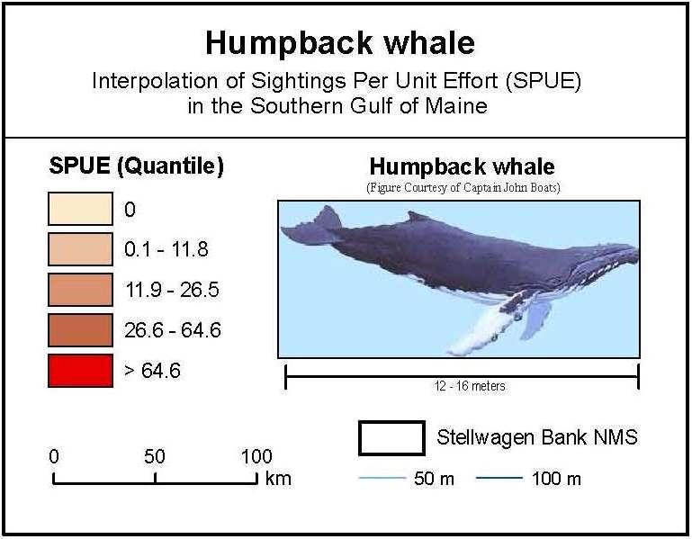
13 Results: Cetacean Distributions

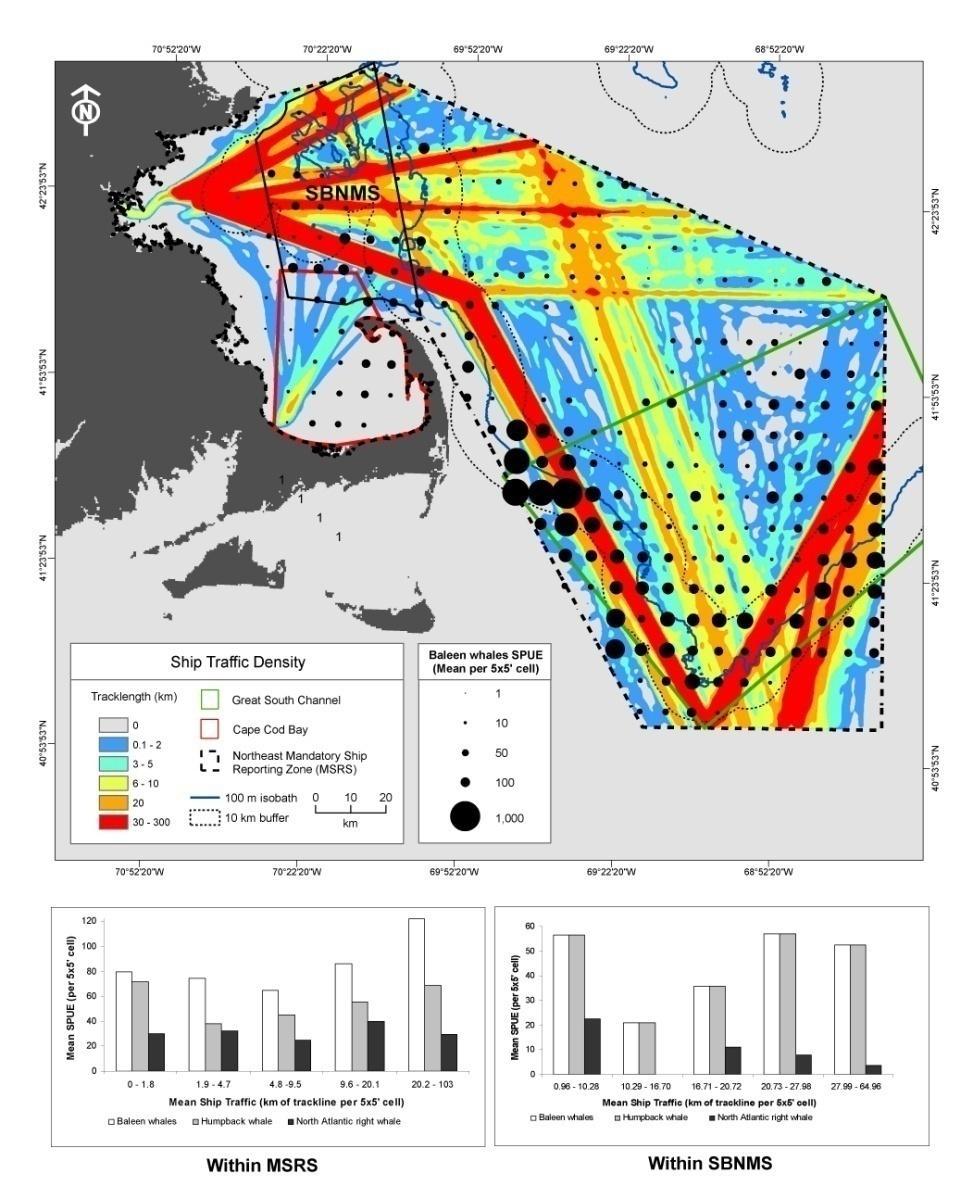
14 Applications


15 Data Compilation & Integration

16 Assessment: Gray s Reef NMS, GA Opt. # # High ledges Area H ledges # Boats # Res. Sites K Resulted in 31,135 options! Objective: To measure the benefits and impacts of potential management zoning actions: Balancing needs of recreational boaters, fishermen, researchers, conservation
 Mean Bird Diversity OAI (relative) High Diversity Area OAI (absolute) NAA 3745 1.485 2284 - - - - - 5 4536 1.487 2812 21 0.13 23.12 0.00638 1.094 4 7981 1.523 5507 113 2.56 141.")
17 Assessment: Southern California Bight, CA Concept 1a Concept 2 Concept 3 Concept 4 Concept 5 Concept Area (km 2 ) Mean Bird Diversity High Diversity Area (km 2 ) D Area (%) D Mean Diversity (%) D High Diversiy Area (%) Mean Bird Diversity OAI (relative) High Diversity Area OAI (absolute) NAA a SA Objective: To evaluate alternative boundary concepts proposed for the Channel Islands National Marine Sanctuary: Balancing needs of local stakeholders


18 Assessment: Southern California Bight, CA Map of proposed site Subsequent uses: MLPA, CCC. The California Coastal Commission used predictive models of seabird distribution to identify potential ecological impacts of placing a liquid natural gas storage facility offshore of LA
19 Biogeographic Assessment of Florida s Coral Reef Tract An analytical process to inform: A) FKNMS Management Plan Review and Zoning B) SEFCRI Management Options Identification Process


20 NOAA CRCP (Funding) Project Team Clients FKNMS Management (NOAA & FWC) SEFCRI Process Planning Team Chris Jeffrey Theresa Goedeke Shay Viehman Moe Nelson Angela Orthmeyer Matt Kendall Dana Wusinich-Mendez Benjamin Ruttenberg Rene Baumstark Partners Providers of DATA SETS & Information
21 FCRT Project: Project Status 1. Identification of relevant management issues and questions 2. Data compilation 3. Data Integration, analysis, & review 4. Product creation, roll-out, dissemination, and support
22 FCRT Project: Identification of Management Issues and Questions Manager workshops hosted in July 2011 Draft Summary of Management Priorities and Data/Analytic Needs Geographies of Interest Habitats of Interest Regulatory, Legal & Management Layers Social, Economic & Human Use Layers Species-Specific Priorities Types of Data Needed Types of Analysis Requested
23 FCRT Project: Overarching Goal 1. Describe the distribution of resource species and benthic composition 2. Couple social, economic and human use data to observed spatial patterns along the reef tract 3. Integrate data on ecological and human use patterns so that development of coastal management and spatial planning would be based on the best available science
24 FCRT Project: Proposed Outputs & Products A geodatabase with GIS layers showing the spatial distribution of marine resources and human uses Maps and analyses characterizing spatial consistency and variation in regulations and managed activities across the FCRT A spatial bibliography on commercially and recreationally important species and their governing regulations, policies, and jurisdictional authorities Products will be tailored to meet the needs of each region (e.g., SEFCRI and Florida Keys)
25 Social Science: Social, Economic & Human Use Data Human Demographic Information Legal and Regulatory Boundaries/Zones Coastal Development and Land Use Legal and Regulatory Compliance Watercraft Related Infrastructure Human Use Activities Spatial Use Patterns

26 Social Component: Social, Economic & Human Use Layers

27 Social Component: Social, Economic & Human Use Layers
28 Ecological: biological resources Fishery (e.g., reef fish, tarpon, lobster) & non-fishery species Coral & other reef-associated benthic organisms Seagrass & other soft - bottom communities Crabs & Lobsters Others?

29 Ecological data on living resources

30 Ecological data on living resources
 Initiated in 2009 Methodology transfer Status of FSA sites unknown SEFSC-CCFHR-FWCC partnership")
31 Fish spawning aggregation research Assess reef fish utilization of identified historical spawning sites Split-beam sonar surveys Diver surveys Upper Keys (off Key Largo) Initiated in 2007 Methodology development FSA sites previously fished out Lower Keys (off Key West) Initiated in 2009 Methodology transfer Status of FSA sites unknown SEFSC-CCFHR-FWCC partnership

 detects")


32 Detect fish aggregation using fish finder Scientific split-beam (Simrad EK60) detects fish Acoustic strength indicates size filter large-ish fish Linked to boat s GPS Waypoints placed for diver surveys


33 Near the Tortugas Ecological Reserve North boundary: 2008 & 2009 Medium & large fish Densities in EEZ increase toward boundary Densities higher in Reserve TNER Boundary EEZ TNER
34 Benthic Mapping: A Unified Benthic Habitat Map Source: FWC / Florida Wildlife Research Institute, St. Petersburg, FL


35 Benthic Mapping: A Unified Benthic Habitat Map Source: FWC / Florida Wildlife Research Institute, St. Petersburg, FL
36 Spatial Bibliography What is it? Bibliographic data linked to a geographic framework. Why do it? Organizes existing information in geographic context, enabling questions of where. Doesn t this already exist? Close, but not quite. How might this be useful? Conservation and science planning, place-based literature reviews, identify gaps, extract content.
37 Spatial Bibliography Precedent projects in South Florida Everglades Annotated Bibliography (Schmidt 1991) Florida Keys Bibliography (Chiappone and Wright 1996) Dry Tortugas Annotated Bibliography (Schmidt and Pikula 1997) Biscayne Bay Annotated Bibliography (Cantillo et al. 2000) Florida Bay Imagery and Information, CoastView Vol. 1 Current projects online bibliographies Everglades Digital Library Regional Databases at NOAA Miami Regional Library at AOML Virtual Libraries: Dry Tortugas, Biscayne Bay, Florida Bay FKNMS Sanctuary Publications Florida FWRI Publications and Technical Reports ReefBase Online Library Online metadata search engines Florida GAME, Gulf GAME CORIS Florida
38 Spatial Bibliography Do these existing projects meet current needs? If not, how to add value without duplicating effort? What questions can be addressed? What information sources to include? What areas to focus on? What spatial scale is appropriate? What spatial delineation? watersheds/ estuaries / islands / inshore / offshore clinal gradient Dry Tortugas to St. Lucie political boundaries jurisdictional boundaries lat / lon grid-based framework
39 Spatial Bibliography Database Design linking Biblio table to spatial framework Field Name bibid (link to spatial framework and other tables) Title Author(s) Year Organization Type of Document Publication Info Web Location Filename Electronic data availability FCRT Regions County(s) Waterbody Number(s) Type of Information FCRT Species FCRT Habitat Types Groupings of fields: Primary bibliographic information = What Electronic availability Spatial footprint = Where Species and habitats

40 Spatial Bibliography Current scope build useable data tables Next steps develop online queryable database?

41 Spatial Bibliography What kind of output would be useful?

42 Spatial Bibliography Tool development want vs. need vs. feasibility Query interface map-based and/or pull-down menus? And who would maintain and host long-term?
43 FCRT Project: Timeline Year Compile & generate data layers for geo-database and spatial bibliography database; develop detailed analytical plan based on outcome of scoping meetings and expert working group; Year Data integration & analysis; generate draft & final map products (e.g, resource distribution) for review; Year Final product development, dissemination, and project wrap-up
44 FCRT Project: Next Steps Identify, acquire and compile any additional, critical datasets Finalize dataset(s) and conduct analyses Review of Analyses by clients & partners Work with managers to develop relevant and useful products
Biogeographic Approach to Coastal Assessments & Spatial Planning
 NOAA s Biogeographic Approach to Coastal Assessments & Spatial Planning Mark E. Monaco Mark.Monaco@noaa.gov Center for Coastal Monitoring and Assessment http://ccma.nos.noaa.gov/about/biogeography Biogeography
Marine Spatial Planning: A Tool for Implementing Ecosystem-Based Management
 Marine Spatial Planning: A Tool for Implementing Ecosystem-Based Management Steven Murawski, Ph.D., Ecosystem Goal Team Lead National Oceanic and Atmospheric Administration NOAA November 16, 2009 1 To
Introduction: The Gulf of Mexico Alliance. The Gulf GAME project MERMAid and PHINS Results & Conclusions What s next? Examples
 AAG Las Vegas March 25, 2009 Introduction: Ocean governance and Ecosystem-Based Management The Gulf of Mexico Alliance Habitat Identification and Characterization The Gulf GAME project MERMAid and PHINS
Geospatial Decision Support Tools for Planning of Marine Protected Areas in California
 Geospatial Decision Support Tools for Planning of Marine Protected Areas in California WILL MCCLINTOCK (UNIVERSITY OF CALIFORNIA SANTA BARBARA), MATT MERRIFIELD (THE NATURE CONSERVANCY), SOPHIE DE BEUKELAER
SW Florida Escarpment Mapping Area
 Overview NOAA s Okeanos Explorer (EX) Program plans to conduct systematic mapping and telepresence-enabled ROV explorations in the Gulf of Mexico during Spring 2014. In 2011, the EX conducted mapping operations
SAFMC Habitat and Ecosystem IMS. Habitat and Environmental Protection Advisory Panel Meeting
 SAFMC Habitat and Ecosystem IMS Habitat and Environmental Protection Advisory Panel Meeting Charleston, SC November 18, 2008 Project Overview Phase 1 develop and host an Internet Map Server (IMS) application
Progress Report: Assessment of Existing Information
 Progress Report: Assessment of Existing Information Atlantic Coastal Fish Habitat Partnership (ACFHP) Steering Committee Rehoboth Beach, Delaware, October 22, 2008 David Moe Nelson Tom McGrath Adam Zitello
an accessible interface to marine environmental data Russell Moffitt
 an accessible interface to marine environmental data Russell Moffitt The Atlas Project GOAL: To provide a single point of access to oceanographic and environmental data for use by marine resource researchers,
Sister Sanctuaries: Linking the Science and Management of Coral Reefs in Cuba and the U.S.
 Sister Sanctuaries: Linking the Science and Management of Coral Reefs in Cuba and the U.S. Memorandum of Understanding on Cooperation in the Conservation and Management of Marine Protected Areas Seventh
9.0 Consistency with the Magnuson-Stevens Fishery Conservation and Management Act (MSFCMA)
") 9.0 Consistency with the Magnuson-Stevens Fishery Conservation and Management Act (MSFCMA) This analysis was prepared in accordance with the requirements of the Magnuson- Stevens Fishery Conservation and
9.0 Consistency with the Magnuson-Stevens Fishery Conservation and Management Act (MSFCMA) This analysis was prepared in accordance with the requirements of the Magnuson- Stevens Fishery Conservation and
Capturing a Holistic Understanding of a Large Marine Ecosystem The NOAA Gulf of Mexico Data Atlas
 Capturing a Holistic Understanding of a Large Marine Ecosystem The NOAA Gulf of Mexico Data Atlas NODC / National Coastal Data Development Center gulfalas.noaa.gov Need: data that contribute to long-term
Natura 2000 in the marine environment: state of implementation and next steps
 Life on the blue planet: biodiversity research and the new European marine policies EPBRS European Platform on Biodiversity Research Strategy Porto, Portugal 7-9 November 2007 Natura 2000 in the marine
Socioeconomic Profile and Spatial Analysis of Fisheries in the three central California National Marine Sanctuaries
 Socioeconomic Profile and Spatial Analysis of Fisheries in the three central California National Marine Sanctuaries 23 + 30 March 2004 Charles Steinback and Astrid Scholz Outline Who we are and why we
GEOGRAPHIC INFORMATION SYSTEMS AND IT SOLUTIONS FOR THE ENVIRONMENT
 GEOGRAPHIC INFORMATION SYSTEMS AND IT SOLUTIONS FOR THE ENVIRONMENT Mission We focus on Solutions is a worldwide operating business offering Geographic Information Systems and IT solutions to assist environmental
Designing Networks of Marine Protected Areas in DFO s Three Atlantic Bioregions
 Designing Networks of Marine Protected Areas in DFO s Three Atlantic Bioregions Presentation for Indigenous Protected Areas Workshop Max Westhead, DFO and Adrian Gerhartz-Abraham, Dalhousie March 29, 2017
Kate Labrum
 2010-2011 Bren Group Project Proposal Boats, Whales, & the Santa Barbara Channel: An economic analysis & policy options for reducing the risk of vessel strikes to endangered whales Bren Student Proposers
STAMP Spa)al Tools for Arc)c Mapping & Planning. Creating an interactive data tool to improve access and usability of Arctic data
al Tools for Arc)c Mapping & Planning. Creating an interactive data tool to improve access and usability of Arctic data") STAMP Spa)al Tools for Arc)c Mapping & Planning Creating an interactive data tool to improve access and usability of Arctic data Mission Provide easy access to physical, chemical, and biological data Network
STAMP Spa)al Tools for Arc)c Mapping & Planning Creating an interactive data tool to improve access and usability of Arctic data Mission Provide easy access to physical, chemical, and biological data Network
Outline. - Background of coastal and marine conservation - Species distribution modeling (SDM) - Reserve selection analysis. - Results & discussion
 - Reserve selection analysis. - Results & discussion") Application of GIS for data preparation and modeling for coastal and marine conservation planning in Madagascar Rija Rajaonson Technical Assistant, REBIOMA Wildlife Conservation Society Madagascar Outline
Application of GIS for data preparation and modeling for coastal and marine conservation planning in Madagascar Rija Rajaonson Technical Assistant, REBIOMA Wildlife Conservation Society Madagascar Outline
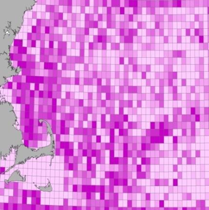
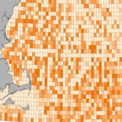
Sea Turtle Sightings Per Unit Effort (Fall) Northwest Atlantic United States January 2010
 Northwest Atlantic United States January 2010") Sea Turtle Sightings Per Unit Effort (Fall) Northwest Atlantic United States January 2010 Prepared by: Eastern Division Conservation Science Office of The Nature Conservancy 99 Bedford Street, 5 th Floor
Sea Turtle Sightings Per Unit Effort (Fall) Northwest Atlantic United States January 2010 Prepared by: Eastern Division Conservation Science Office of The Nature Conservancy 99 Bedford Street, 5 th Floor
WELCOME & INTRODUCTION
 MPA Management Capacity Building Training Module 1: WELCOME & INTRODUCTION Participants Distinguished Guests Welcome Site Overviews of MPAs represented Overview of Training Program What are Today s Objectives?
Geographic Response Plan Mapping and Digital Area Contingency Plan
 Geographic Response Plan Mapping and Digital Area Contingency Plan Ryan Druyor Digital ACP Coordinator Florida Fish and Wildlife Conservation Commission Fish and Wildlife Research Institute Background
Building capacity to support decisionmaking for protection and management of marine areas
 Credit_Deep Atlantic Stepping Stones Science Team_IFE_URI_NOAA_no3 Credit: John Weller, john@lastocean.com Credit: John Weller, john@lastocean.com Credit: John Weller, john@lastocean.com Credit: Sarah
Northwestern Hawaiian Islands Coral Reef Research Partnership: Ocean Mapping, Ecosystem Threats, and Information Management
 Northwestern Hawaiian Islands Coral Reef Research Partnership: Ocean Mapping, Ecosystem Threats, and Information Management Malia Chow Papahanaumokuakea Marine National Monument National Oceanic and Atmospheric
Food for thoughts. Jon Davies MESH Project Coordinator
 Food for thoughts Jon Davies MESH Project Coordinator You are not alone.. There is someone out there.. Habmap UKSeaMap MESH Why is he here? Introduce the MESH Project, give a brief overview of other marine
Introducing the. a partnership of
 Introducing the a partnership of Background Need for online atlas identified by managers and researchers to make coastal data available Shoreline data Ocean and coastal resources Sea-level rise potential
NOAA s OCM: Services, tools and collaboration opportunities & Puerto Rico s NE Marine Corridor as a case study
 NOAA s OCM: Services, tools and collaboration opportunities & Puerto Rico s NE Marine Corridor as a case study Dr. Antares Ramos Álvarez NOAA s Office of Coastal Management September 15 th, 2016 Conservation
Integration for Informed Decision Making
 Geospatial and Statistics Policy Intervention: Integration for Informed Decision Making Greg Scott Global Geospatial Information Management United Nations Statistics Division Department of Economic and
MARCO s Mapping and Planning Portal. Coastal Geotools 2011 Special Interest Meeting-CMSP Portals & Atlases March 21, 2011 Jay Odell
 MARCO s Mapping and Planning Portal Coastal Geotools 2011 Special Interest Meeting-CMSP Portals & Atlases March 21, 2011 Jay Odell Overview What is a Portal? Description and demo of Mapping and Planning
STATEMENT OF CAPABILITY
 BELIZE MARINE CONSERVATION AND CLIMATE ADAPTATION PROJECT (MCCAP) Ministry of Forestry, Fisheries and Sustainable Development STATEMENT OF CAPABILITY Consultant for the Realignment of Boundaries and the
Alexandra Carvalho, Ph.D., GISP Kathy Fitzpatrick, P.E.
 Coastal Data Organization for Project Management and Coastal Planning Martin County, Florida Alexandra Carvalho, Ph.D., GISP Kathy Fitzpatrick, P.E. Outline County Coastal Programs Coastal Geodatabase
Country Fiche Estonia
 Country Fiche Estonia Updated October 2017 1. General information Size of internal waters (to the baseline) and territorial sea (12-nm zone from the baseline) approximately 25 200 km 2. Exclusive economic
GEBCO 2013 TSCOM. EMODNET Hydrography status report
 www.emodnet-hydrography.eu GEBCO 2013 TSCOM EMODNET Hydrography status report Eric Moussat, Ifremer on behalf of the Emodnet consortium 1 Background and objectives EU proposed to take steps in 2008 towards
2012 FORUM OF MARINE PROTECTED AREAS IN THE MEDITERRANEAN ANTALYA, TURKEY
 2012 FORUM OF MARINE PROTECTED AREAS IN THE MEDITERRANEAN ANTALYA, TURKEY SPECIAL EVENT Challenges for Open Seas MPAs in the Mediterranean region November 27, 2012. 15h00-16H00 Slide # 1 2012 FORUM OF
Opening their Shells Getting commercial clammers involved in marine spatial planning
 Opening their Shells Getting commercial clammers involved in marine spatial planning Ed Lewandowski Coastal Communities Development Specialist University of Delaware/Delaware Sea Grant Highlights Background
Abstract. Introduction
 Southern California Aquaculture Site Assessment Model Caitlyn Raines University of Redlands Master of Science in Geographic Information Systems Program Abstract The Southern California Aquaculture Site
Country Fiche Estonia
 Country Fiche Estonia Deleted: October Updated May 2018 Deleted: 7 1. General information Size of internal waters (to the baseline) and territorial sea (12-nm zone from the baseline) approximately 25 200
Assessment of Benthic Coral Reef Organisms in Dry Tortugas National Park and the Western Florida Keys National Marine Sanctuary
 Assessment of Benthic Coral Reef Organisms in Dry Tortugas National Park and the Western Florida Keys National Marine Sanctuary 2008 Quick Look Report and Data Summary December 2009 Steven L. Miller 1,
CLIMAR-III Third JCOMM Workshop on Advances in Marine Climatology 6-9 May Gdynia, Poland
 CLIMAR-III Third JCOMM Workshop on Advances in Marine Climatology 6-9 May 2008. Gdynia, Poland Catherine Marzin Historical Ecology Program Manager National Marine Sanctuary Program Stefan Claesson Research
Mapping ecosystem services provided by benthic habitats in the European Atlantic Ocean
 Mapping and Assessment Ecosystem Services and Links to Good Environmental Status Mapping ecosystem services provided by benthic habitats in the European Atlantic Ocean Ibon Galparsoro, Angel Borja and
Outline National legislative & policy context Regional history with ESSIM ESSIM Evaluation Phase Government Integration via RCCOM Regional ICOM Framew
 What MSP Implementation could change in the Maritimes Region Tim Hall, Regional Manager Oceans and Coastal Management Division Ecosystem Management Branch Fisheries and Oceans Canada Maritimes Region BIO
Offshore Video Survey and Oceanographic Analysis: Georges Bank to the Chesapeake project
 Non-Technical Synopsis of the Offshore Video Survey and Oceanographic Analysis: Georges Bank to the Chesapeake project Executive Summary Dave Bethoney Kristin Kleisner Mark Anderson Changsheng Chen Bradley
ICAN Great Lakes 2010 Workshop
 ICAN Great Lakes 2010 Workshop Chris Cortina Maryland s Chesapeake & Coastal Program MD Department of Natural Resources Maryland s Coastal Atlas: What is it? The Coastal Atlas is an online mapping and
Marine Spatial Data for Marine Spatial Planning. Ocean Leadership 2010 Public Policy Forum
 Marine Spatial Data for Marine Spatial Planning Ocean Leadership 2010 Public Policy Forum March 10, 2010 Edward Saade President, Fugro EarthData, Inc 1 Marine Spatial Data What is Marine Spatial Data?
Population Trends Along the Coastal United States:
 Coastal Trends Report Series Population Trends Along the Coastal United States: 1980-2008 U.S. Department of Commerce National Oceanic and Atmospheric Administration National Ocean Service Assessing the
Introduction to Part III Examining wildlife distributions and abundance using boat surveys
 Baseline Wildlife Studies in Atlantic Waters Offshore of Maryland: Final Report to the Maryland Department of Natural Resources and Maryland Energy Administration, 2015 Introduction to Part III Examining
MESMA: An integrated tool box to support an ecosystem based spatial management of marine areas
 MESMA: An integrated tool box to support an ecosystem based spatial management of marine areas Stelzenmüller, V., Stamford, T., Vassilopoulou, V., Kastanevakis, S., Vincx, M, Vanaverbeke, J., Rabaut, M.,
Coastal Response Research Center. Nancy Kinner University of New Hampshire (UNH) Michele Jacobi NOAA ORR. September 27, 2007
 Michele Jacobi NOAA ORR. September 27, 2007") Coastal Response Research Center Nancy Kinner University of New Hampshire (UNH) Michele Jacobi NOAA ORR September 27, 2007 1 Coastal Response Research Center (CRRC) CRRC is partnership between NOAA s Office
Coastal Response Research Center Nancy Kinner University of New Hampshire (UNH) Michele Jacobi NOAA ORR September 27, 2007 1 Coastal Response Research Center (CRRC) CRRC is partnership between NOAA s Office
1) make sure folks know what s available in terms of geospatial data and resources that could contribute to their decision support toolkits;
 make sure folks know what s available in terms of geospatial data and resources that could contribute to their decision support toolkits;") Introduction 1 2001 It was born out of the recognition that several of the regions prominent resource management agencies have similar, if not shared, requirements for GIS data. Some of the underlying
Introduction 1 2001 It was born out of the recognition that several of the regions prominent resource management agencies have similar, if not shared, requirements for GIS data. Some of the underlying
National Marine Sanctuary Program
 National Marine Sanctuary Program NMSP/USGS Joint Seabed Mapping Initiative: September 2004 AA National Ocean Service National Marine Sanctuaries Interim Report September 2004 Background: Since 2002,
GIS-Based Sediment Quality Database for the St. Louis River Area of Concern (AOC): Overview Presentations and Demonstration
: Overview Presentations and Demonstration") GIS-Based Sediment Quality Database for the St. Louis River Area of Concern (AOC): Overview Presentations and Demonstration Judy L. Crane 1 and Dawn E. Smorong 2 1 Minnesota Pollution Control Agency, St.
GIS-Based Sediment Quality Database for the St. Louis River Area of Concern (AOC): Overview Presentations and Demonstration Judy L. Crane 1 and Dawn E. Smorong 2 1 Minnesota Pollution Control Agency, St.
Overview of Methods. Terrestrial areas that are most important for conservation Conservation
 Overview of Methods The goal of the Western Lake Erie Coastal Conservation Vision project (WLECCV) is to define where we should be working locally to optimally achieve regional conservation impact. The
BOEM Marine Minerals Program
 BOEM Marine Minerals Program Restoring and Protecting Our Nation s Coasts through Stewardship of OCS Sand Resources SECOORA 2018 Annual Meeting May 22-24 Doug Piatkowski Douglas.piatkowski@boem.gov 703-787-1833
Mapping Maine s Working Waterfront: for Our Heritage and Economy
 Mapping Maine s Working Waterfront: for Our Heritage and Economy Abstract Mapping Maine s Working Waterfronts is a collaborative project led by the Island Institute that inventories the state s current
Developing Soil Maps and Interpretations for Shallow Subtidal Habitats
 Developing Soil Maps and Interpretations for Shallow Subtidal Habitats James D. Turenne Assistant State Soil Scientist Rhode Island (The Ocean State) USDA-NRCS Narragansett Bay Estuary LNB Coastal Lagoons
A Comparison of the Social Valuation of Ecosystem Services in Urban and Rural Contexts
 A Comparison of the Social Valuation of Ecosystem Services in Urban and Rural Contexts Jarrod L. Loerzel College of Charleston Zachary D. Cole University of Florida Presentation Map 1. What is SolVES?
MARINE SPATIAL PLANNING
 MARINE SPATIAL PLANNING Washington Uses Spatial Planning to Honor its Pacific Coast and Offshore Waters Past, Present and Future The Washington State Pacific Coast and offshore waters are diverse in both
EASTERN SCOTIAN SHELF INTEGRATED OCEAN MANAGEMENT PLAN
 Government of Canada Gouvernement du Canada EASTERN SCOTIAN SHELF INTEGRATED OCEAN MANAGEMENT PLAN SUMMARY Photo Credits: Bedford Institute of Oceanography Published by: Oceans and Habitat Branch Fisheries
Spatial Planning in Canada s Maritimes Region. Maritimes Region
 Spatial Planning in Canada s Maritimes Region Glen Herbert, Scott Coffen-Smout Smout,, and Tanya Koropatnick Oceans and Coastal Management Division Ecosystem Management Branch Fisheries and Oceans Canada
Environmental Response Management Application
 Environmental Response Management Application Coastal Response Research Center Nancy Kinner, Michele Jacobi, Rob Braswell, Kurt Schwehr & Amy Merten RRT III May 14, 2008 1 Talk Outline Overview of Center
Marine Sanctuaries Conservation Series ONMS 06-04
 Marine Sanctuaries Conservation Series ONMS 06-04 Conservation Science in NOAA s National Marine Sanctuaries: Description and Recent Accomplishments U.S. Department of Commerce National Oceanic and Atmospheric
Marine Spatial Planning (MSP): A practical approach to ecosystembased
: A practical approach to ecosystembased") Marine Spatial Planning (MSP): A practical approach to ecosystembased management Erik Olsen, Institute of Marine Research, Norway Fanny Douvere, International Oceanographic Commission Overview Why we need
Marine Spatial Planning (MSP): A practical approach to ecosystembased management Erik Olsen, Institute of Marine Research, Norway Fanny Douvere, International Oceanographic Commission Overview Why we need
BIOGEOGRAPHIC ASSESSMENTS: INTEGRATION OF ECOLOGY AND GIS TO DEFINE AND EVALUATE MARINE PROTECTED AREA BOUNDARIES
 BIOGEOGRAPHIC ASSESSMENTS: INTEGRATION OF ECOLOGY AND GIS TO DEFINE AND EVALUATE MARINE PROTECTED AREA BOUNDARIES Mark E. Monaco, Chris Caldow, and John D. Christensen Introduction The world s marine resources
Use of Elevation Data in NOAA Coastal Mapping Shoreline Products. Coastal GeoTools April 1, 2015
 Use of Elevation Data in NOAA Coastal Mapping Shoreline Products Coastal GeoTools April 1, 2015 - NOAA s Coastal Mapping Program & CUSP - Shoreline Uses, Delineation Issues, Definitions - Current Extraction
RECOMMENDED STUDY PLAN 2018
 RECOMMENDED STUDY PLAN 208 NAME STUDENT NUMBER DEGREE PROGRAM Graduate Diploma of Science MAJOR Marine Biology (MBY) Level 5: Year SP3 SP SP6/7 SP2 SP0/SP Major Core: Major Skill Core: Major Core: Major
Land Use Methods & Metrics Development Outcome
 Quarterly Progress Meeting November 15, 2018 Land Use Methods & Metrics Development Outcome Peter Claggett, USGS LUWG Coordinator Through the Chesapeake Bay Watershed Agreement, the Chesapeake Bay Program
III. Acropora coral habitat distribution
 2008 Quick Look Report: Miller et al. III. Acropora coral habitat distribution Background The declines in abundance of two of the principal Caribbean reef-building corals, staghorn coral (Acropora cervicornis)
MISSOURI LiDAR Stakeholders Meeting
 MISSOURI LiDAR Stakeholders Meeting East-West Gateway June 18, 2010 Tim Haithcoat Missouri GIO Enhanced Elevation Data What s different about it? Business requirements are changing.fast New data collection
Habitat Mapping in The Hauraki Gulf Marine Park. Dan Breen
 Habitat Mapping in The Hauraki Gulf Marine Park Dan Breen Outline 1. Intro Habitat mapping 2. Coastal marine habitats and marine protected areas in the New Zealand Territorial Sea: a broad scale gap analysis
GEOGRAPHIC INFORMATION SYSTEMS AND OCEAN MAPPING IN SUPPORT OF FISHERIES MANAGEMENT. T. Noji, J. Pederson, and C. Adams MITSG 06-8
 GEOGRAPHIC INFORMATION SYSTEMS AND OCEAN MAPPING IN SUPPORT OF FISHERIES MANAGEMENT T. Noji, J. Pederson, and C. Adams MITSG 06-8 Sea Grant College Program Massachusetts Institute of Technology Cambridge,
Jacqueline M. Grebmeier Chesapeake Biological Laboratory University of Maryland Center for Environmental Science, Solomons, MD, USA
 Update on the Pacific Arctic Region Synthesis Activity as part of the ICES/PICES/PAME Working Group on Integrated Ecosystem Assessment of the Central Arctic Ocean (WGICA) Jacqueline M. Grebmeier Chesapeake
LA POLÍTICA MARÍTIMA INTEGRADA
 LA POLÍTICA MARÍTIMA INTEGRADA Ministerio de Agricultura, Alimentación y Medio Ambiente Juan Luís Suárez de Vivero 2 4 de abril de 2014, Madrid INTEGRATED MARINE POLICY 1. PLANES, MARCO JURÍDICO-ADMINISTRATIVO,
Digital EIA - The Increasing Use of GIS
 Digital EIA - The Increasing Use of GIS The Benefits of Using GIS Tools in the EIA Process Gary Benson GIS Consultant, AECOM Environment Topics to be considered: 1. What is GIS? 2. What can GIS do/what
IWG-OCM Update For NCSS
 IWG-OCM Update For NCSS Data Supporting Science and Sound Decision-Making Ashley Chappell January 9, 2018 NOAA IOCM Coordination Team Members National Environmental Satellite, Data and Information Service:
Florida Reef Tract Coral Bleaching Response Plan
 Florida Reef Tract Coral Bleaching Response Plan Meaghan Johnson, The Nature Conservancy January 21, 2016 Bleaching Response Plan Developed in 2013 Unified plan for responding to coral bleaching events
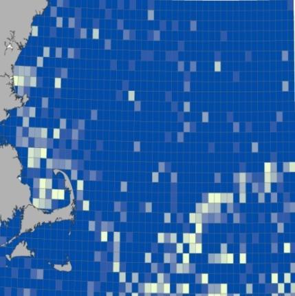
Soft sediments by grain size (in mm) Northwest Atlantic United States March 2016
 Northwest Atlantic United States March 2016") Soft sediments by grain size (in mm) Northwest Atlantic United States March 2016 Prepared for: Northeast Regional Ocean Council (NROC) Northeast Ocean Data www.northeastoceandata.org Prepared by: Eastern
Soft sediments by grain size (in mm) Northwest Atlantic United States March 2016 Prepared for: Northeast Regional Ocean Council (NROC) Northeast Ocean Data www.northeastoceandata.org Prepared by: Eastern
Spatiotemporal Patterns of Coral Bleaching and Disease along the Florida Reef Tract. Brian K. Walker & Amanda Costaregni
 Spatiotemporal Patterns of Coral Bleaching and Disease along the Florida Reef Tract Brian K. Walker & Amanda Costaregni Congratulations!! Objectives 1. Identify areas where spatial clustering of significantly
Lesser Sunda - Banda Seascape Atlas
 Lesser Sunda - Banda Seascape Atlas Report prepared for the development of online interactive map for Lesser Sunda Banda Seascape by WorldFish December 2014 http://sbsatlas.reefbase.org Page 1 of 8 Table
ACRONYMS AREAS COUNTRIES MARINE TERMS
 Natura 2000 ACRONYMS AREAS COUNTRIES MARINE TERMS DEFINITION A European network of protected sites under the European Habitats and Birds Directives, aiming to protect the most valuable and threatened European
BalticBOOST Appendix 1, WP 3.3 Deliverable 1 Final report 14 February 2017
 Theme 1: Biodiversity This is a deliverable from the BalticBOOST project that was coordinated by HELCOM and co-financed by the European Union in 2015-2016 as part of the programme DG ENV/MSFD Action Plans/2016.
Kyle Griebel NRS 509 Dr. August & Dr. Wang GIS and remote sensing in Seafloor mapping
 GIS and remote sensing in Seafloor mapping Introduction to seafloor mapping Seafloor maps have a wide variety of uses for scientists and coastal planning needs. Some of these uses include biological assessment
Marine Spatial Management Tool
 Marine Spatial Management Tool Marine Spatial Management Tool Support the marine spatial planning process with updated and reliable geospatial information Marine management is important to Norway with
Marine Transportation and Ocean Use
 Marine Transportation and Ocean Use Data Needs for Multi-Disciplinary Long-Term Planning 4 th Biennial TRB-CMTS Research and Development Conference Matt Campo Rutgers University 6/22/2016 Overview What
Australia s Marine Bioregional Planning
 Australia s Marine Bioregional Planning And possible lessons for areas beyond national jurisdiction Nautilus (Dr M. Norman, Museum Victoria) Butterfly fish & Yellowback Fusiliners (R.Thorn) Soft coral
Birch Creek Geomorphic Assessment and Action Plan
 Birch Creek Geomorphic Assessment and Action Plan Jim Webster Tim Hanrahan, PhD, CFM Jesse Schwartz, PhD Zach Hill January 22, 2015 White Eagle Grange This Project is a First Step in Strategy Planning
Regional-scale understanding of the geologic character and sand resources of the Atlantic inner continental shelf, Maine to Virginia
 Regional-scale understanding of the geologic character and sand resources of the Atlantic inner continental shelf, Maine to Virginia Workshop on Dredging, Beach Nourishment and Bird Conservation Atlantic
Applications of Geographic Information Systems (GIS) and Remote Sensing (RS) in Marine Spatial Planning
 and Remote Sensing (RS) in Marine Spatial Planning") Ryan Rezendes Dr. August and Dr. Wang NRS 509 Applications of GIS and Remote Sensing Overview and Annotated Bibliography Fall Semester 14 December 2017 Applications of Geographic Information Systems (GIS)
Ryan Rezendes Dr. August and Dr. Wang NRS 509 Applications of GIS and Remote Sensing Overview and Annotated Bibliography Fall Semester 14 December 2017 Applications of Geographic Information Systems (GIS)
Coastal Viewer Mapping Application:
 Coastal Viewer Mapping Application: MAPPING OF COASTAL PUBLIC PROPERTY, THE COASTAL PROTECTION ZONE BOUNDARIES AND AUDITING OF STRUCTURES ON THE COASTAL PUBLIC PROPERTY 15 May 2014 INTEGRATED COASTAL MANAGEMENT
Ecological and Economic Effects of Derelict Fishing Gear in the Chesapeake Bay. Amy V. Uhrin Chief Scientist NOAA Marine Debris Program
 Ecological and Economic Effects of Derelict Fishing Gear in the Chesapeake Bay Amy V. Uhrin Chief Scientist NOAA Marine Debris Program Briefing for: Chesapeake Bay Program Management Board October 13,
IV. Distribution and Abundance of Acropora Corals
 IV. Distribution and Abundance of Acropora Corals Background The declines in abundance of two of the principal Caribbean reef-building corals, staghorn coral (Acropora cervicornis) and elkhorn coral (A.
Water Atlas Overview. Myakka River Management Coordinating Council June 22, 2012 Englewood, Florida
 Water Atlas Overview Myakka River Management Coordinating Council June 22, 2012 Englewood, Florida What is the Water Atlas? A data warehouse A set of interactive maps A collection of tools for viewing/analyzing
Dorset MSP Evidence Base 18 th February Ness Smith C-SCOPE Project Officer
 Dorset MSP Evidence Base 18 th February 2011 Ness Smith C-SCOPE Project Officer Sectoral Topic Papers MMA Description document gives an overview of the area, it s physical and human influences 20 Topic
Marine Spatial Planning in the Baltic Sea Region
 Marine Spatial Planning in the Baltic Sea Region Towards coherence and cross-border solutions in Baltic Maritime Spatial Plans Coordinator & Project manager Dr Ingela Isaksson Swedish Agency for Marine
Bathymetry. EMODnet Stakeholder Conference & Sea-basin Workshops February Bathymetry
 EMODnet Stakeholder Conference & Sea-basin Workshops 14-15 February 2017 Arctic checkpoint Belinda Kater On behalf of all Checkpoints http://www.emodnet.eu 1 ? is the study of the "beds" or "floors" of
Case Study: Bulgarian part of the Black Sea
 Application of the MESMA Framework. Case Study: Bulgarian part of the Black Sea Schipper C.A. 1 Todorova V. 2, Doncheva V. 2 1 Deltares, P.O.Box 177, 2600 MH Delft, The Netherlands 2 Institute of Oceanology
Data Management for Algal Monitoring in the Gulf of Mexico
 Data Management for Algal Monitoring in the Gulf of Mexico Scott Cross NOAA National Oceanographic Data Center/ Coastal Data Development Center (NCDDC) Outline History Current & Future Directions Needs
Overview. Gulf of Mexico Alliance Ocean and Coastal Mapping Regional Ecosystem Data Management (REDM) Q2O (QARTOD to OGC) Things to Consider
 Q2O (QARTOD to OGC) Things to Consider") 1 Overview Gulf of Mexico Alliance Ocean and Coastal Mapping Regional Ecosystem Data Management (REDM) Q2O (QARTOD to OGC) Things to Consider 2 Gulf Of Mexico Alliance Partnership of the states of Alabama,
1 Overview Gulf of Mexico Alliance Ocean and Coastal Mapping Regional Ecosystem Data Management (REDM) Q2O (QARTOD to OGC) Things to Consider 2 Gulf Of Mexico Alliance Partnership of the states of Alabama,
Marine/Maritime Spatial Planning Andrej Abramić
 Marine/Maritime Spatial Planning Andrej Abramić EcoAqua SUMMER SCHOOL: Ecosystem approach to aquaculture 26-29th of October 2015 Research and Technology to enhance excellence in Aquaculture development
A TOOLKIT FOR MARINE SPATIAL PLANNING Version: 17 July, 2009
 A TOOLKIT FOR MARINE SPATIAL PLANNING Version: 17 July, 2009 NEED FOR MARINE SPATIAL PLANNING The health of marine ecosystems is declining, and use conflicts in the marine environment are increasing, in
Natura 2000 and spatial planning. Executive summary
 Natura 2000 and spatial planning Executive summary DISCLAIMER The information and views set out in this study are those of the author(s) and do not necessarily reflect the official opinion of the Commission.
OCEANOGRAPHIC DATA MANAGEMENT
 OCEANOGRAPHIC DATA MANAGEMENT Presented to: Environmental Disaster Data Management Meeting Russ Beard Director, National Coastal Data Development Center Interim Science Coordinator, Gulf Restoration Council