Integrating geology in reality mesh? François ROBIDA BRGM (French Geological Survey)
|
|
|
- Diana Sims
- 5 years ago
- Views:
Transcription

1 Integrating geology in reality mesh? François ROBIDA BRGM (French Geological Survey) > 1
2 UNDERSTANDING geological phenomena and associated risks. THE FRENCH GEOLOGICAL SURVEY THE BRGM IS FRANCE S LEADING PUBLIC INSTITUTION WORKING IN EARTH SCIENCE APPLICATIONS FOR THE MANAGEMENT OF SURFACE AND SUBSURFACE RESOURCES AND RISKS. ITS ACTIVITIES ARE GEARED TO SCIENTIFIC RESEARCH, SUPPORT TO PUBLIC POLICY DEVELOPMENT AND INTERNATIONAL COOPERATION. DEVELOPING new methodologies and techniques. PRODUCING and disseminating data to support the management of soils, subsoils and their resources. DELIVERING the necessary tools for managing soils, subsoils and their resources, preventing risks and pollution and developing climate change policies. Over 1000 staff including more than 700 engineers and researchers
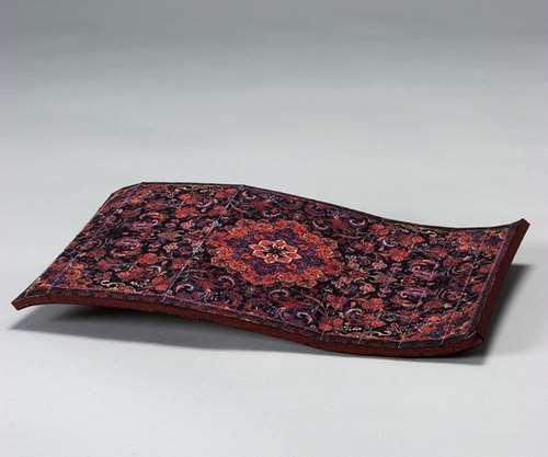
3 OUR INFRASTRUCTURES AND CITIES ARE NOT LAYING ON A FLYING CARPET > 3
4 > 4
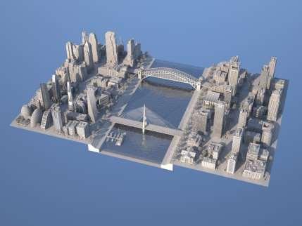
5 > 5

6 > 6

7 Key challenges for smart / sustainable / resilient cities and infrastructures dependent of subsurface knowledge > Geo-Hazards : ground stability, subsidence, earthquake, flooding > Resources / services : water, geothermal energy, energy storage, building materials > Remediation of polluted soils, urban wastelands > In the context of climate change and energy transition > and of increasing conflict of usage of the underground We need an holistic modelling of cities that integrates the subsurface (and the other components of the natural environment as air, water, biodiversity) Geological surveys, environmental agencies are information providers and data custodians > 7
8 Why is it difficult to merge modelling of built environment and geology? Built environment Geology Modelling process Complete design by human Progressive exploration, and understanding (increasing complexity) Data acquisition Relatively cheap (Lidar ) Expensive and indirect Modelling tools CAD engineering software geomodellers (interpolation algorithms) Standards BIM CityGML Accuracy / uncertainty Usualy well known (design construction) For 2d : GeoSciML Not for 3D (still software dependent) Difficult to estimate, communicate, and represent Visualisation VR tools for general public for experts only People Engineers Natural scientists > 8


9 However, there are already examples / experiments City of Lyon City of Toulouse Paris Basin > 9


10 However, there are already examples / experiments > But without shared best practices, common standards and real integration in current urban models > 10
 standards for 3D geology (new OGC group!")
11 We must address the needs of smart cities and large infrastructures > Deliver data / information / products for shallow subsurface > In partnership with municipalities / engineering and utilities companies / > Through agreed (new) standards for 3D geology (new OGC group!) interoperable with BIM standards (Building Information Modelling) > Which makes possible the integration of geology with city models > 11

12 Recent initiatives > 12

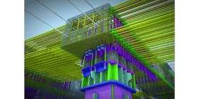
13 Proposed Underground Infrastructure Pilot presented to NYC Mayor s office, May 2016 > 3D integration of underground critical infrastructure with secure online services for multiple applications Routine operations, emergency response with cascading failures, withstand cyber attacks Foster coordination of local, state, federal governments and utilities > Suitable to any urban environment, e.g., New York City Existing Municipal Data Sets Simplifying complex network structures Department of Geoinformation Science Every utility network consist of 3 main functions: 1. distribution Underground objects (pipes, Infrastructure canals, cables etc.) Data Model Needed for transport and distribution of commodity Pipe Long-Distance Heat citygml:track citygml:road citygml:track Secured Online Access Pipe - Gas Pipe - Pipe - FreshWater coolingenergy Pipe - WasteWater 8 Becker, T., Nagel, C., Kolbe, T. H. - Semantic 3D modeling of multi-utility networks in cities Copyright 2016 Open Geospatial Consortium


14 MINnD > Interoperable Information Model for Sustainable Infrastructures > A French consortium of 60 partners > 1 goal : enhancing BIM capabilities for infrastructure modeling and management (complete lifecycle of infrastructures) > 14
 description Relationship with its natural environment > Objectives Contribute to standardisation activity in")
15 MINnD Underground Infrastructure > Specific use case : standardizing underground infrastructure description process > One main sponsor (French nuclear waste agency) Importance of building and environment relationship > Two main topics and working groups Built environment (tunnels ) description Relationship with its natural environment > Objectives Contribute to standardisation activity in OGC + BSI > 15
16 Final remarks > We must not ignore the hidden / unknown part of reality in our «reality mesh» that is our natural environment > Requires cooperation between actors from different skills, disciplines, organisations standards are key for developing this interoperability this is the right timing to engage! > 16

17 THANK YOU FOR YOUR ATTENTION FRANÇOIS ROBIDA
BIM and INSPIRE, for a better integration of built infrastructures in their environment : the MINnD project
 BIM and INSPIRE, for a better integration of built infrastructures in their environment : the MINnD project François ROBIDA Christophe CASTAING Strasbourg, > 1 8 septembre 2017 ABOUT BIM Building Information
a national geological survey perspective François ROBIDA BRGM (French Geological Survey)
") a national geological survey perspective François ROBIDA BRGM (French Geological Survey) Pre-Conference Seminar on Socio-Economic Value of Geospatial for National and Regional Development 21 August 2017,
a national geological survey perspective François ROBIDA BRGM (French Geological Survey) Pre-Conference Seminar on Socio-Economic Value of Geospatial for National and Regional Development 21 August 2017,
SMART CITIES NEED LOCATION DATA
 SMART CITIES NEED LOCATION DATA Carsten Rönsdorf 27 May 2015 Lisbon Future Cities need Location Data Geospatial World Forum 27 May 2015 Carsten Rönsdorf, Head of Advisory Services, OS International OFFICIAL
Oman NSDI Business Values and Future Directions. Hassan Alawi Alghazali Acting Director General National Spatial Data Infrastructure
 Oman NSDI Business Values and Future Directions Hassan Alawi Alghazali Acting Director General National Spatial Data Infrastructure Presentation Outline Geospatial Maturity Current Challenges NCSI s Role
On the convergence of 3D-GIS, CAD and 3D Simulation
 On the convergence of 3D-GIS, CAD and 3D Simulation V. Coors, Stuttgart University of Applied Science, Volker.Coors@hft-stuttgart.de Urban information space Due to improved tools for the design and acquisition
IDBE. Common conceptual framework and roadmap of collaboration in Spatial Standards for the Digital Built Environment
 IDBE Common conceptual framework and roadmap of collaboration in Spatial Standards for the Digital Built Environment GeoBIM: 3D GIS in China Mei Xue: In my opinion, what matters most in the integration
Advancing Geoscientific Capability. Geological Survey of Finland
 Advancing Geoscientific Capability Geological Survey of Finland GTK in brief The Geological Survey of Finland (GTK) is one of the largest European centres of excellence in assessment, research and the
Exploit your geodata to enable smart cities and countries
 Exploit your geodata to enable smart cities and countries Carsten Rönsdorf, Head of Advisory Services Middle East Practice Manager Future Cities, standards and 3D 24 November 2014 Importance of Standards
KUNMING FORUM ON UNITED NATIONS GLOBAL GEOSPATIAL INFORMATION MANAGEMENT CITIES OF THE FUTURE: SMART, RESILIENT
 KUNMING FORUM ON UNITED NATIONS GLOBAL GEOSPATIAL INFORMATION MANAGEMENT CITIES OF THE FUTURE: SMART, RESILIENT and SUSTAINABLE Yunnan Zhenzhuang Guest House, Kunming, China 10 12 May 2017 BACKGROUND CONCEPT
Plan4all (econtentplus project)
") Plan4all (econtentplus project) Karel CHARVAT 1, Tomáš MILDORF 2 1 Help service remote sensing, Ltd., Černoleská 1600, 256 01 Benešov u Prahy, Czech Republic charvat@bnhelp.cz 2 Department of Mathematics
Plan4all (econtentplus project) Karel CHARVAT 1, Tomáš MILDORF 2 1 Help service remote sensing, Ltd., Černoleská 1600, 256 01 Benešov u Prahy, Czech Republic charvat@bnhelp.cz 2 Department of Mathematics
COMBINING URBAN METABOLISM METHODS AND SEMANTIC 3D CITY MODELS
 COMBINING URBAN METABOLISM METHODS AND SEMANTIC 3D CITY MODELS Ihab Hijazi 1,2, Vanessa Ebert 1, Andreas Donaubauer 1, Thomas H. Kolbe 1 1 Chair of Geoinformatics Technical University of Munich 2 An-Najah
DEPARTMENT OF GEOLOGY AND MINERAL INDUSTRIES WAYS & MEANS SUBCOMMITTEE ON NATURAL RESOURCES MARCH 2, 2017
 DEPARTMENT OF GEOLOGY AND MINERAL INDUSTRIES WAYS & MEANS SUBCOMMITTEE ON NATURAL RESOURCES MARCH 2, 2017 1 ABOUT DOGAMI AGENCY MISSION, VISION & GOALS 2 Lidar image of a stream network along the Umpqua
Geographic Information Infrastructure and Policy Framework for Sustainable Mountain Development in the Hindu Kush-Himalayas
 Geo SMART ASIA 2017 22-24 August, Kualalampur Geographic Information Infrastructure and Policy Framework for Sustainable Mountain Development in the Hindu Kush-Himalayas Basanta Shrestha, Director Strategic
GEOMATICS. Shaping our world. A company of
 GEOMATICS Shaping our world A company of OUR EXPERTISE Geomatics Geomatics plays a mayor role in hydropower, land and water resources, urban development, transport & mobility, renewable energy, and infrastructure
Pushing the Standards Edge: Collaborative Testbeds to Accelerate Standards Development and Implementation
 Pushing the Standards Edge: Collaborative Testbeds to Accelerate Standards Development and Implementation Mark E. Reichardt President mreichardt@opengeospatial.org 31 October 2006 2006 Open Geospatial
Presentation of the gicases case studies Carlo Cipolloni ISPRA Giorgio Saio GISIG Dirk Frigne GEOSPARC Elena Krikigianni EPSGR
 Presentation of the gicases case studies Carlo Cipolloni ISPRA Giorgio Saio GISIG Dirk Frigne GEOSPARC Elena Krikigianni EPSGR 1 Which are the gicases Case study? CS1 - Use of indoor GIS in healthcare
Land Use in the context of sustainable, smart and inclusive growth
 Land Use in the context of sustainable, smart and inclusive growth François Salgé Ministry of sustainable development France facilitator EUROGI vice president AFIGéO board member 1 Introduction e-content+
US National Spatial Data Infrastructure A Spatial Framework for Governance and Policy Development to Enable a Location-Based Digital Ecosystem
 GeoPlatform Workshop 7 Dec 2016, Department of the Interior Washington, D.C. US National Spatial Infrastructure A Spatial Framework for Governance and Policy Development to Enable a Location-Based Digital
THE ROLE OF GEOSPATIAL AT THE WORLD BANK
 THE ROLE OF GEOSPATIAL AT THE WORLD BANK INSPIRE Conference Barcelona, Spain September 26, 2016 Kathrine Kelm Senior Land Administration Specialist Global Land and Geospatial Unit The World Bank Group
Geological Survey of Canada Lands and Minerals Sector Natural Resources Canada OneGeology, June 2018
 Geological Survey of Canada Lands and Minerals Sector Natural Resources Canada OneGeology, June 2018 Geological Survey of Canada Mission The Geological Survey of Canada provides public geoscience knowledge
EuroSDR (European Spatial Data Research)
") EuroSDR (European Spatial Data Research) ROLLING RESEARCH PLAN 2015-2018 EuroSDR Secretariat Public Governance Institute KU Leuven Parkstraat 45 bus 3609 3000 Leuven Belgium Tel.: +32 16 32 31 80 Fax:
EuroSDR (European Spatial Data Research) ROLLING RESEARCH PLAN 2015-2018 EuroSDR Secretariat Public Governance Institute KU Leuven Parkstraat 45 bus 3609 3000 Leuven Belgium Tel.: +32 16 32 31 80 Fax:
Land Administration and Cadastre
 Geomatics play a major role in hydropower, land and water resources and other infrastructure projects. Lahmeyer International s (LI) worldwide projects require a wide range of approaches to the integration
Norwegian spatial data infrastructure supporting disaster risk management Norwegian Mapping Authority
 Norwegian spatial data infrastructure supporting disaster risk management Norwegian Mapping Authority Arvid Lillethun, Norwegian Mapping Authority Land and Poverty 2018 Conference, World Bank 19.-23. March
E-Government and SDI in Bavaria, Germany
 135 E-Government and SDI in Bavaria, Germany Wolfgang STOESSEL, Germany Key words: GDI-BY, Bavaria, Spatial Data Infrastructure SUMMARY Spatial Data Infrastructure (SDI) is an important part of the e-government
Enabling Access to Arctic Location Based Information - the Arctic SDI
 Enabling Access to Arctic Location Based Information - the Arctic SDI Jani Kylmäaho Head of Arctic SDI Geoportal WG National Land Survey of Finland SAO Chair, WG Chairs and Executive Secretaries meeting
RETA 6422: Mainstreaming Environment for Poverty Reduction Category 2 Subproject
 RETA 6422: Mainstreaming Environment for Poverty Reduction Category 2 Subproject A. Basic Data 1. Subproject Title: Poverty-Environment Mapping to Support Decision Making 2. Country Director: Adrian Ruthenberg
Graduate Courses Meteorology / Atmospheric Science UNC Charlotte
 Graduate Courses Meteorology / Atmospheric Science UNC Charlotte In order to inform prospective M.S. Earth Science students as to what graduate-level courses are offered across the broad disciplines of
Strategic considerations for geospatial collection development from Greek Academic Libraries in an open access era: GIS users point of view
 Ifigenia Vardakosta1,2 Sarantos Kapidakis1 1Laboratory on Digital Libraries and Electronic Publishing Department of Archive, Library and Museum Sciences, Faculty of Information Science and Informatics
International Union of Geodesy and Geophysics. Resolutions
 International Union of Geodesy and Geophysics Resolutions ADOPTED BY THE COUNCIL AT THE XXVI GENERAL ASSEMBLY PRAGUE, CZECH REPUBLIC (22 JUNE 2 JULY 2015) 0 Page Resolution 1: Role of Ocean in Climate
Supporting GPSC Cities with Satellite Earth Observation for Sustainable Urban Development
 Supporting GPSC Cities with Satellite Earth Observation for Sustainable Urban Development Global Platform for Sustainable Cities African Regional Workshop 14 May 2018 AfDB Headquarters Abidjan, Côte d'ivoire
BIM and Geomatics / GIS Integration Malaysian and Turkish Perspectives
 BIM and Geomatics / GIS Integration Malaysian and Turkish Perspectives Alias Abdul Rahman (UTM), Umit Isikdag (MSGSU), Sedat Bakici (TKGM) and Kherun Nita Ali (UTM) Contents Introduction Malaysian perspectives
INTEGRATED HEAVY RAIN RISK MANAGEMENT
 INTEGRATED HEAVY RAIN RISK MANAGEMENT Newsletter #1 June 2017 November 2017 RAINMAN finally started 2 What do we plan to do 3 Kick-off meeting in Vienna 5 Scoping workshop on risk assessment and mapping
OGC s Underground Information Activities
 OGC s Underground Information Activities Dr. Ingo Simonis representing Bart de Lathouwer Director Innovation Program & Science, OGC December 2017 Copyright 2017 Open Geospatial Consortium The OGC Mission
Building Institutional Capacity for Multi-Hazard Early Warning in Asia and the Pacific Subtitle
 Building Institutional Capacity for Multi-Hazard Early Warning in Asia and the Pacific Subtitle Title Keran Wang Chief, Space Applications Section ICT and Disaster Risk Reduction Division 22 May 2018 Pillar
about GCC
 about GCC Bldg 234, Flat 11, Al Barakat Street, Hail Al Janaubiyah P.O Box: 94, Postal Code: 123, Al Khaudh, Sultante of Oman Fax : +968 24543188 Mobile :+968 96666445 info@gcc-oman.com www.gcc-oman.com
Chapter 10: BIM for Facilitation of Land Administration Systems in Australia
 Chapter 10: BIM for Facilitation of Land Administration Systems in Australia Sam Amirebrahimi Introduction With the introduction of the concept of 3D Cadastre and extensive efforts in this area, currently
VISUALIZING THE SMART CITY 3D SPATIAL INFRASTRUCTURE GEOSMART ASIA- 30 SEP, 2015
 www.aamgroup.com VISUALIZING THE SMART CITY 3D SPATIAL INFRASTRUCTURE GEOSMART ASIA- 30 SEP, 2015 Agenda AAM What is a Smart City? Data Acquisition 3D Modelling Benefits Questions AAM AAM is a Geospatial
3D Urban Information Models in making a smart city the i-scope project case study
 UDC: 007:528.9]:004; 007:912]:004; 004.92 DOI: 10.14438/gn.2014.17 Typology: 1.04 Professional Article 3D Urban Information Models in making a smart city the i-scope project case study Dragutin PROTIĆ
Geospatial Information Management in the Americas: Lessons for the Post-2015 development agenda
 Geospatial Information Management in the Americas: Lessons for the Post-2015 development agenda Rolando Ocampo President, UN-GGIM: Americas October 2014 The integration of statistical and geographical
Chapter 2 Land Use Management and Risk Communication
 Chapter 2 Land Use Management and Risk Communication Michiko Banba Abstract Land use represents a relationship between natural and urban environment. Land use management is the way of managing land use
Arctic Spatial Data Infrastructure Enabling Access to Arctic Location-Based Information
 Arctic Spatial Data Infrastructure Enabling Access to Arctic Location-Based Information Arctic SDI Side Event Co-Chairs: Arvo Kokkonen Arctic SDI Board Chair & Director General, National Land Survey of
Mark E Reichardt. President & CEO Open Geospatial Consortium
 Mark E Reichardt President & CEO Open Geospatial Consortium mreichardt@myogc.org Agenda 0900-0915 Welcome and Introduction - Topic setting (Chair) 0915-0935 Ron Bloksma, The next step is interoperability
Applying Hazard Maps to Urban Planning
 Applying Hazard Maps to Urban Planning September 10th, 2014 SAKAI Yuko Disaster Management Expert JICA Study Team for the Metro Cebu Roadmap Study on the Sustainable Urban Development 1 Contents 1. Outline
INDONESIA S S UPDATE: GEOSPATIAL INFORMATION FOR SUSTAINABLE DEVELOPMENT RELATED TO INA SDI Dr. Asep Karsidi, M.Sc
 INDONESIA S S UPDATE: GEOSPATIAL INFORMATION FOR SUSTAINABLE DEVELOPMENT RELATED TO INA SDI Dr. Asep Karsidi, M.Sc GEOSPATIAL INFORMATION AGENCY 08 August, 2012 OUTLINE 1. Transformation Bakosurtanal into
Scope and design principles of the CityGML Utility Network ADE
 Scope and design principles of the CityGML Utility Network ADE Tatjana Kutzner, Thomas H. Kolbe Chair of Geoinformatics kutzner@tum.de, thomas.kolbe@tum.de Joint Energy ADE and Utility Network ADE workshop
Strengthening Cooperation on International Rivers:
 Strengthening Cooperation on International Rivers: Transboundary Ecosystem Services as a Policy Tool (a theoretical perspective integrating Political Science & Ecology) Olivier Petit (U. of Artois, France)
Short Note 3D modeling of subsurface utilities using Ground Penetrating Radar (GPR) data
 data") 217 Short Note 3D modeling of subsurface utilities using Ground Penetrating Radar GPR data Arnab Dutta and Sameer Saran Geoinformatics Department, Indian Institute of Remote Sensing, ISRO, Dehradun, India
217 Short Note 3D modeling of subsurface utilities using Ground Penetrating Radar GPR data Arnab Dutta and Sameer Saran Geoinformatics Department, Indian Institute of Remote Sensing, ISRO, Dehradun, India
Spatial Data Infrastructure Concepts and Components. Douglas Nebert U.S. Federal Geographic Data Committee Secretariat
 Spatial Data Infrastructure Concepts and Components Douglas Nebert U.S. Federal Geographic Data Committee Secretariat August 2009 What is a Spatial Data Infrastructure (SDI)? The SDI provides a basis for
National workshop on sustainable urban and industry development in Mongolia objective, expected outcomes and schedule
 GEO-REF Information Eco-Efficient Urban Infrastructure, and Platform Green for & Disaster Livable Management Cities National workshop on sustainable urban and industry development in Mongolia objective,
Natural Hazards Large and Small
 Specialty Seminar on Engineering of Geo-Hazards ASCE Met Section Geotechnical Group and Geo-Institute of ASCE 16 May 2007 Natural Hazards Large and Small Evaluation and Mitigation Edward Kavazanjian, Jr.,
INSPIRing effort. Peter Parslow Ordnance Survey December Various European approaches to managing an SDI
 INSPIRing effort Peter Parslow Ordnance Survey December 2015 Various European approaches to managing an SDI WHAT IS INSPIRE? A European Union Directive A community effort: http://inspire.ec.europa.eu/
Semantic 3D City Models for Urban Information Fusion and City Lifecycle Management
 Technische Universität Berlin Semantic 3D City Models for Urban Information Fusion and City Lifecycle Management Thomas H. Kolbe Institute for Geodesy & Geoinformation Science Technische Universität Berlin
We recommend you cite the published version. The publisher s URL is:
 Ludlow, D. and Khan, Z. (2011) GMES and INSPIRE: Harmonising cross-thematic environmental data for integrated intelligence. In: 2nd GMES Operational Workshop, Sofia, Bulgaria, 17th - 18th March 2011. Available
Preface: Mountain hazards and risks! !only a matter of climate change?
 Preface: Mountain hazards and risks!?!only a matter of climate change? Preface Preface: it s a matter of available space!! It a matter of scale!. A piece of! Coastal Belt and Intermontane Basin Preface
UN GGIM and National SDI Strategy
 MSDI Open Forum on 26 th January 2016 Contributing to the successful delivery of MSDI UN GGIM and National SDI Strategy Hiroshi Murakami Deputy Administrator Geospatial Information Authority of Japan Geospatial
2 nd EUROGI imagine Conference 2014 GI - Expertise Made in Europe 8 & 9 October 2014 in Berlin, Germany
 GEO-INFORMATION FOR JOB CREATION AND ECONOMIC GROWTH Conference block organised by the French Umbrella Association for Geospatial Information Moderator: Rapporteur: François Salgé AFIGéO Executive committee
(2008) 8 (6) ISSN
 8 (6) ISSN") Le Cozannet, Gonéri and Hosford, Steven and Douglas, John and Serrano, Jean-Jacques and Coraboeuf, Damien and Comte, Jérémie (2008) Connecting hazard analysts and risk managers to sensor information. Sensors,
Le Cozannet, Gonéri and Hosford, Steven and Douglas, John and Serrano, Jean-Jacques and Coraboeuf, Damien and Comte, Jérémie (2008) Connecting hazard analysts and risk managers to sensor information. Sensors,
Adding value to Copernicus services with member states reference data
 www.eurogeographics.org Adding value to Copernicus services with member states reference data Neil Sutherland neil.sutherland@os.uk GIS in the EU 10 November 2016 Copyright 2016 EuroGeographics 61 member
GMES EURORISK Geo-information services for natural and man-made risks management
 GMES EURORISK Geo-information services for natural and man-made risks management 8/11/2004 EURORISK A European scale approach for developing, delivering and operationally exploiting new information services
Use of geo-referenced data for DRM in Central Asia, problems and prospective
 Use of geo-referenced data for DRM in Central Asia, problems and prospective Dr. Akylbek Chymyrov Director, Kyrgyz Center of Geoinformation Systems Member of the Public Supervisory Board MES KR KSUCTA,
Flash Flood Guidance System On-going Enhancements
 Flash Flood Guidance System On-going Enhancements Hydrologic Research Center, USA Technical Developer SAOFFG Steering Committee Meeting 1 10-12 July 2017 Jakarta, INDONESIA Theresa M. Modrick Hansen, PhD
From Vulnerability to Resilience And the Tools to Get There. Out of Harm s Way Partnership for the Delaware Estuary August 1, 2012
 From Vulnerability to Resilience And the Tools to Get There Out of Harm s Way Partnership for the Delaware Estuary August 1, 2012 Today s Presentation Tour of New Jersey Challenges Definitions so we re
IGOS Geohazards: toward an improved use of Earth Observations for Geohazards mitigation
 IGOS Geohazards: toward an improved use of Earth Observations for Geohazards mitigation Scientific and Technical Subcommittee session Vienna, 15th February 2007 Gonéri Le Cozannet IGOS Geohazards Bureau
Health DWG ad-hoc. May 31 st, 2013 OGC-TC
 Health DWG ad-hoc May 31 st, 2013 OGC-TC AGENDA 1. Welcome / Roundtable Introductions 2. Background of OGC and proposal of Health DWG 3. Toward an OGC Health DWG 4. Draft Health DWG Charter 5. Potential
USGS National Geospatial Program Understanding User Needs. Dick Vraga National Map Liaison for Federal Agencies July 2015
 + USGS National Geospatial Program Understanding User Needs Dick Vraga National Map Liaison for Federal Agencies July 2015 + Topics 2 Background Communities of Use User Surveys National Map Liaisons Partnerships
GIS at UCAR. The evolution of NCAR s GIS Initiative. Olga Wilhelmi ESIG-NCAR Unidata Workshop 24 June, 2003
 GIS at UCAR The evolution of NCAR s GIS Initiative Olga Wilhelmi ESIG-NCAR Unidata Workshop 24 June, 2003 Why GIS? z z z z More questions about various climatological, meteorological, hydrological and
Interpretive Map Series 24
 Oregon Department of Geology and Mineral Industries Interpretive Map Series 24 Geologic Hazards, and Hazard Maps, and Future Damage Estimates for Six Counties in the Mid/Southern Willamette Valley Including
Compact guides GISCO. Geographic information system of the Commission
 Compact guides GISCO Geographic information system of the Commission What is GISCO? GISCO, the Geographic Information System of the COmmission, is a permanent service of Eurostat that fulfils the requirements
Georeferencing and Satellite Image Support: Lessons learned, Challenges and Opportunities
 Georeferencing and Satellite Image Support: Lessons learned, Challenges and Opportunities Shirish Ravan shirish.ravan@unoosa.org UN-SPIDER United Nations Office for Outer Space Affairs (UNOOSA) UN-SPIDER
International 3D Developments. Jantien Stoter Professor 3D GeoInformation
 International 3D Developments Jantien Stoter Professor 3D GeoInformation European Spatial Data Research EuroSDR 3D Special Interest Group Active participants: Swisstopo, Ordnance Survey UK, Ordnance Survey
THREE-DIMENSIONAL DATA MODELLING FOR UNDERGROUND UTILITY NETWORK MAPPING
 THREE-DIMENSIONAL DATA MODELLING FOR UNDERGROUND UTILITY NETWORK MAPPING Jingya YAN 1, Siow Wei JAW 1,2,3, Rob Van Son 1, Kean Huat SOON 4, Gerhard SCHROTTER 5 1 ETH Zurich, Future Cities Laboratory, Singapore-ETH
Foundation Geospatial Information to serve National and Global Priorities
 Foundation Geospatial Information to serve National and Global Priorities Greg Scott Inter-Regional Advisor Global Geospatial Information Management United Nations Statistics Division UN-GGIM: A global
Spatial decision making in Armenia based on multidisciplinary environmental research
 EU FP7 EcoArm2ERA Integration into ERA Integration of spatial decision support systems and evidence based modeling in National/Regional Policy applications and regulatory systems: scientific and policy
National Geographic Institute (IGN)
") (IGN) National Centre of Geographic Information (CNIG) Tenth United Nations Regional Cartographic Conference of the Americas New York, 19-23 August 2013 Spanish National Land Observation Program (PNOT)
(IGN) National Centre of Geographic Information (CNIG) Tenth United Nations Regional Cartographic Conference of the Americas New York, 19-23 August 2013 Spanish National Land Observation Program (PNOT)
Practice of Shanghai Multi-Hazard Early Warning System (MHEWS) CHEN Zhenlin Director-General, Shanghai Meteorological Service, CMA May 22, 2017
 CHEN Zhenlin Director-General, Shanghai Meteorological Service, CMA May 22, 2017") Practice of Shanghai Multi-Hazard Early Warning System (MHEWS) CHEN Zhenlin Director-General, Shanghai Meteorological Service, CMA May 22, 2017 Outline Ⅰ. Background and Practices -- WMO demonstration
Practice of Shanghai Multi-Hazard Early Warning System (MHEWS) CHEN Zhenlin Director-General, Shanghai Meteorological Service, CMA May 22, 2017 Outline Ⅰ. Background and Practices -- WMO demonstration
The Spatial Data Infrastructure for the Geological Reference of France
 The Spatial Data Infrastructure for the Geological Reference of France Marc Urvois, Thierry Baudin, Florence Cagnard, Philippe Calcagno, Nicolas Chauvin, Ulrich Clain, Santiago Gabillard, Sandrine Grataloup,
The UN-GGIM: Europe core data initiative to encourage Geographic information supporting Sustainable Development Goals Dominique Laurent, France
 INSPIRE conference Strasbourg 6 September 2017 The UN-GGIM: Europe core data initiative to encourage Geographic information supporting Sustainable Development Goals Dominique Laurent, France Introduction
Coastal Mapping Follow on? Bruno Frachon Corine Lochet Gaël Morvan
 Coastal Mapping Follow on? Bruno Frachon Corine Lochet Gaël Morvan Shared objectives; IHO DG MARE CPMR Development of a Joint European Coastal Mapping Programme (JECMaP) within the IHO EU network with
A contribution to GEOSS from the SDI for Georesources in Africa
 A contribution to GEOSS from the SDI for Georesources in Africa A. TELLEZ-ARENAS BRGM, France in behalf of: Dr. Marc URVOIS Project Coordinator BRGM, France Mineral Resources Division INSPIRE Conference
Subject map. Custodians Geological Curators Group Geoscience Information Group Higher Education Network History of Geology Group
 Subject map In preparing the science strategy during 2013, Science and External Relations Committee (SERC) thought about how best to map the structure of geoscience, identifying its main disciplines, sub-disciplines
Basics of GIS reviewed
 Basics of GIS reviewed Martin Breunig Karlsruhe Institute of Technology martin.breunig@kit.edu GEODETIC INSTITUTE, DEPARTMENT OF CIVIL ENGINEERING, GEO AND ENVIRONMENTAL SCIENCES, CHAIR IN GEOINFORMATICS
Investigating the practical relationship between GIS and BIM; then relating that to a 3D cadastre. J. Gabriel van Wyk, Johan Nel
 Investigating the practical relationship between GIS and BIM; then relating that to a 3D cadastre. J. Gabriel van Wyk, Johan Nel Overview So exactly what is BIM? Available BIM offerings in the market Traditional
European Spatial Data Research. EuroSDR. Prof. Dr. Ir. Joep Crompvoets. General Assembly CLGE Tirana 18 March
 EuroSDR Prof. Dr. Ir. Joep Crompvoets General Assembly CLGE - 2016 Tirana 18 March 2016 INTRODUCTORY QUESTIONS Who knows what is EuroSDR? Who does NOT know what is EuroSDR? Who is employed at mapping agencies?
Spatial Analysis of Natural Hazard and Climate Change Risks in Peri-Urban Expansion Areas of Dakar, Senegal
 1 Spatial Analysis of Natural Hazard and Climate Change Risks in Peri-Urban Expansion Areas of Dakar, Senegal URBAN WEEK 2009 BBL Preston Lounge Thursday, March 12, 2009 Christian Hoffmann GeoVille group
Geoinformation Science at TU Berlin
 Technische Universität Berlin Department of Geoinformation Science Geoinformation Science at TU Berlin Prof. Dr. Thomas H. Kolbe Institute for Geodesy and Geoinformation Science Berlin University of Technology
ADVANTAGES OF GIS-INTEGRATED MARITIME DATA IN THE BLACK SEA REGION FOR MULTIPURPOSE USE
 INTERAGENCY INTERACTION IN CRISIS MANAGEMENT AND DISASTER RESPONSE 2017 ADVANTAGES OF GIS-INTEGRATED MARITIME DATA IN THE BLACK SEA REGION FOR MULTIPURPOSE USE Lyubka Pashova 1, Anna Kortcheva 2, Vasko
OGC Pilot Future Cities. 3D Stadt modelle, 9/11 Bonn
 Pilot Future Cities 3D Stadt modelle, 9/11 Bonn Bart De Lathouwer / Athina Trakas Open Geospatial Consortium Setting the stage Geo and BIM, how do they relate? Identify the issues How we pilot the solutions
Baltic 2030: Bumps on the Road
 Sven Beyersdorff June 14th 2018 Baltic 2030: Bumps on the Road - How the Baltic Sea States are performing on the SDGs Aims of report Why did we do this? Understand performance of 11 countries in the Baltic
Land Accounts - The Canadian Experience
 Land Accounts - The Canadian Experience Development of a Geospatial database to measure the effect of human activity on the environment Who is doing Land Accounts Statistics Canada (national) Component
Geo-hazard Potential Mapping Using GIS and Artificial Intelligence
 Geo-hazard Potential Mapping Using GIS and Artificial Intelligence Theoretical Background and Uses Case from Namibia Andreas Knobloch 1, Dr Andreas Barth 1, Ellen Dickmayer 1, Israel Hasheela 2, Andreas
Harmonizing spatial databases and services at local and regional level
 Harmonizing spatial databases and services at local and regional level A. Ionita 1, M. Caian 2, V. Vassilev 3, V. Craciunescu 2, I. Nedelcu 4 1 Research Institute for Artificial Intelligence, Bucuresti,
SYNERGY OF SATELLITE REMOTE SENSING AND SENSOR NETWORKS ON GEO GRID
 SYNERGY OF SATELLITE REMOTE SENSING AND SENSOR NETWORKS ON GEO GRID National Institute of Advanced Industrial Science and Technology, Japan Yoshio Tanaka (on behalf of AIST GEO Grid team) Contents Brief
Overview of CityGML. Dave Capstick, Ordnance Survey Research Department
 Overview of CityGML Dave Capstick, Ordnance Survey Research Department Introduction Why is citygml necessary CityGML development who is responsible? Ordnance Surveys interest 3D modelling basic concepts
Weather Climate Science to Service Partnership South Africa
 PROJECTS UNDERWAY Title of the Weather Climate Science to Service Partnership South Africa Together, building on an existing strong partnership, South African Weather Service and the Met Office will build
Press kit Kartotrak 2014 June 2nd, 2014
 Press kit Kartotrak 2014 June 2nd, 2014 Worldwide leader in Geostatistics, Geovariances enables its clients involved with mapping, resource estimation or risk analysis to benefit from more than 25 years
Local EPM Implementation Process in 5 stages
 Local PM Implementation Process in 5 stages 3. Working groups 1. City nvironmental Profile/ Outlook 5. Consolidation & Institutionalisation 4. Strategy & Action plans 2. City Consultation Urban nvironmental
CARTOGRAPHY in a Web World
 CARTOGRAPHY in a Web World SENSE Research Cluster XIII meeting: Concepts and tools for spatial data visualization BAREND KÖBBEN kobben@itc.nl b.j.kobben@utwente.nl Agenda Short introduction to ITC and
SDI DEVELOPMENT UPDATES OF INDONESIA
 SDI DEVELOPMENT UPDATES OF INDONESIA DR. ANTONIUS B. WIJANARTO Center For Management And Dissemination Of Geospatial Information GEOSPATIAL INFORMATION AUTHORITY GOVERNMENT OF THE REPUBLIC OF INDONESIA
The Delaware Environmental Observing System
 The Delaware Environmental Observing System DECISION SUPPORT FOR COASTAL FLOODING AND SNOWFALL Daniel Leathers, State Climatologist, Professor University of Delaware Tina Callahan, DEMAC, University of
Open Cities Project. The World Bank, South Asia Region. Background
 Open Cities Project The World Bank, South Asia Region Opencitiesproject.com Background The World Bank s South Asia Region (SAR) is proud to announce its new Open Cities Project. The goal of this project