International 3D Developments. Jantien Stoter Professor 3D GeoInformation
|
|
|
- Janel Morrison
- 5 years ago
- Views:
Transcription
1 International 3D Developments Jantien Stoter Professor 3D GeoInformation


2 European Spatial Data Research EuroSDR 3D Special Interest Group Active participants: Swisstopo, Ordnance Survey UK, Ordnance Survey Ireland, Kadaster NL, LM Sweden, IGN Belgium, ICGC Catalonia, NLS Finland, GUGIK Poland, IGN France, Denmark, Norway


3 3D is today!

4 But: Potentials of 3D are insufficiently used in geo
5


6 In 2D: important information gets lost


7 3D potentials are insufficiently used Planned situation De Volkskrant 6 January 2016 Realised situation

8 Interactieve 3D omgeving
 www.sonnendach.")
9 Example of good practice of 3D Solarpotential (swissbuildings 3D 2.0) Sonnendach.ch 14
10 3D data have the potential to generate $13 billion in new benefits annually. Snyder, GI, 2012, The 3D Elevation Program Summary of Program Direction U.S. Geological Survey (Fact Sheet )
11 European Spatial Data Research EuroSDR project on economic value of 3D geoinformation for NMAs (2016) Main conclusion: significant positive return on investment from 3D geoinformation even when considering only two use cases in isolation (flooding & urban planning)
12 If 3D techniques have matured.
13 If 3D gives added value.
14 What is the problem?


15 Data, Data, Data Flooding Energy Shadow urban heat island Where do I find usefull 3D data? Solar potential Noise
16 And thus it remains expensive and complicated to use 3D
17 What do we need?
18 3D Geoinformation What do we need (and where are we working on)? 3D (national) standard 3D data maintenance & quality 3D base data 3D data integration


19 (National) 3D standard Solid, uniform base for 3D Makes 3D more efficient Flooding Shadow Energy urban heat island Noise Solar potential


20 In NL: 2D standard for large scale topography Information Model Geography (IMGeo) Mandatory for governmental organisations
21 3D IMGeo?
 standard 3D data maintenance &")


22 Yes! IMGeo modelled as CityGML ADE 3D (national) standard 3D data maintenance & quality 3D base data 3D data integration IMGeo CityGML Vegetation Module W aterbody Module CityFurniture Module Relief Module Tunnel Module Bridge Module Building Module Transportation Module

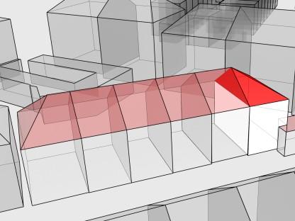
23 CityGML Levels of Detail 3D (national) standard 3D data maintenance & quality 3D base data 3D data integration Filip Biljecki

24

25 Information Model Geography 3D (national) standard 3D data maintenance & quality 3D base data 3D data integration LOD2 LOD1 3D LOD0 IMGeo Boom BGTpand BAGpand 2.5D 2D
 standard 3D data maintenance & quality 3D base data 3D data integration")

26 Specifying Levels of Detail of 3D data Which one is optimal for the application? 3D (national) standard 3D data maintenance & quality 3D base data 3D data integration An improved LOD specification for 3D building models Filip Biljecki, Hugo Ledoux, Jantien Stoter Computers, Environment and Urban Systems, vol. 59, September 2016, pp
 of 3D modelling To have same understanding")

27 European Spatial Data Research Common definition (classification) of 3D modelling To have same understanding (needed for collaboration) To be able to articulate our 3D needs to industry, standardisation organisations, science
28 3D Geoinformation What do we need? 3D national standard 3D data maintenance & quality 3D base data 3D data integration
29 3D data is required 3D (national) standard 3D data maintenance & quality 3D base data 3D data integration Beyond the wow effect Up to date (always) Consistent Authentic Nationwide Without errors etc


30 errors = common in 3D 3D (national) standard 3D data maintenance & quality 3D base data 3D data integration 3
 Reads CityGML By: Hugo Ledoux")
31 Software to validate 3D data 3D (national) standard 3D data maintenance & quality 3D base data 3D data integration free & open-source web interface: According to international standards (ISO19107 & OGC) Reads CityGML By: Hugo Ledoux
32 3D (national) standard 3D data maintenance & quality 3D base data 3D data integration

33 3D (national) standard 3D data maintenance & quality 3D base data 3D data integration
34 3D Geoinformation What do we need? 3D national standard 3D data maintenance & quality 3D base data 3D data integration

")


35 3D data available Ettenheim, Germany (c) Research Center Karlsruhe Provincie Noord Brabant New York Rotterdam Utrecht Den Haag Eindhoven Pariser Platz (c) City of Berlin, Senate of Urban Development
 standard")


36 3D data products 3D (national) standard 3D data maintenance 3D base data 3D data integration Two possibilities 3D as base -> 2D derived Provincie Noord Brabant More often: 3D models are generated from 2D


37 3D NL: available for whole NL + 3D (national) standard 3D data maintenance 3D base data 3D data integration TOP10NL Lidar point clouds

38 3dfier 3D (national) standard 3D data maintenance 3D base data 3D data integration Open-source toolkit to construct (valid!) large 3D city models By: Hugo Ledoux
 standard 3D data")

39 Build and update virtual model NL with 3dfier 3D (national) standard 3D data maintenance 3D base data 3D data integration And link to applications (noise, water)
40 3D Geoinformation What do we need? 3D national standard 3D data maintenance & quality 3D base data 3D data integration
 standard 3D data maintenance 3D base data 3D data integration")
41 Data integration: power of 3D! 3D (national) standard 3D data maintenance 3D base data 3D data integration Smart cities: The city knows what is happening where
")


42 3D GIS BIM 3D (national) standard 3D data maintenance 3D base data 3D data integration Focus area: Concepts: Geographical concepts: space, outdoor shell Constructions Data: Measured Designed
 to CityGML (GIS) Without")

43 BIM-GIS integration 3D (national) standard 3D data maintenance 3D base data 3D data integration = more than geometric conversion from IFC (BIM) to CityGML (GIS) Without interpretation With interpretation Automatic conversion of IFC datasets to geometrically and semantically correct CityGML LOD3 building, Sjors Donkers, Hugo Ledoux, Junqiao Zhao, and Jantien Stoter, 2014
 Develop interface to use: Geo data structured in BIM for BIM app BIM data")
44 Bridging Geo-BIM gap 3D (national) standard 3D data maintenance 3D base data 3D data integration Aims: To reuse each others data To have one, coherent digital view on built environment How?: 1 st step : understand how BIM data is used in Geo and vv Acknowledge the differences (not throwing over the fence ) Develop interface to use: Geo data structured in BIM for BIM app BIM data structured in Geo for Geo app Prepare data for better conversion With experts and users from both domains
 standard")


45 Project GeoBIM 3D (national) standard 3D data maintenance 3D base data 3D data integration 1. open-source API to represent IFC + CityGML with the same data structure 2. Apply to use cases 3. Recommendations for future integration


46 EuroSDR Geo/BIM project 3D (national) standard 3D data maintenance 3D base data 3D data integration European Spatial Data Research Identify use cases Develop appropriate transformation in each use case Formulate recommendations for standardisation organisations (OGC) Partners: OSUK Swisstopo OSI Kadaster ICGC GUGiK IGNF Lantmateriet NLS


47 Example Geo&BIM integration 1st 3D cadastral registration, Railway station Delft Real situation 2D registration 3D registration Prorail Gemeente Delft Railinfratrust BV NS Vastgoed (stations)


48 Added value of 3D
49 Conclusion Advances in 3D Geoinformation Requires: Common 3D base with data beyond the wow effect Standardisation, validation: international collaboration! Most important challenge: 3D data integration Voxel-vector Below and above surface GIS/BIM Across domain boundaries


50 Thanks to all my colleagues 3d.bk.tudelft.nl
Overview of GeoBIM project. Jantien Stoter, Ken Arroyo Ohori, Thomas Krijnen, Hugo Ledoux, GeoBIM conference Amsterdam 24 November 2017
 Overview of GeoBIM project Jantien Stoter, Ken Arroyo Ohori, Thomas Krijnen, Hugo Ledoux, GeoBIM conference Amsterdam 24 November 2017 GeoBIM: We want to integrate because we model the same real world,
European Spatial Data Research. EuroSDR. Prof. Dr. Ir. Joep Crompvoets. General Assembly CLGE Tirana 18 March
 EuroSDR Prof. Dr. Ir. Joep Crompvoets General Assembly CLGE - 2016 Tirana 18 March 2016 INTRODUCTORY QUESTIONS Who knows what is EuroSDR? Who does NOT know what is EuroSDR? Who is employed at mapping agencies?
INSPIRing effort. Peter Parslow Ordnance Survey December Various European approaches to managing an SDI
 INSPIRing effort Peter Parslow Ordnance Survey December 2015 Various European approaches to managing an SDI WHAT IS INSPIRE? A European Union Directive A community effort: http://inspire.ec.europa.eu/
3D implementation at national level Case of The Netherlands
 3D implementation at national level Case of The Netherlands Dr Jantien Stoter Associate professor GIS technology, OTB, Faculty of Architecture and The Built Environment, TUDelft & Consultant innovations
Working with Open BIM standards to source data for a 3D Cadastre Jennifer Oldfield
 Working with Open BIM standards to source data for a 3D Cadastre Jennifer Oldfield j.oldfield@gobar.nl BIM FILE IFC GIS OBJECT LADM Based on Master of Science Geographic Information Management Applications
CityGML & opendrive Urban Simulation Based on Open Standards
 CREATE MAINTAIN DISTRIBUTE 3D Mapping Solutions CityGML & opendrive Urban Simulation Based on Open Standards Dr.-Ing. Stefan Trometer virtualcitysystems GmbH virtualcitysystems Experts for 3D City Models
Data Conversion to I3S for 3D Modeling from CityGML. Christian Dahmen (con terra GmbH) Satish Sankaran (Esri)
 Satish Sankaran (Esri)") Data Conversion to I3S for 3D Modeling from CityGML Christian Dahmen (con terra GmbH) Satish Sankaran (Esri) 3D Across the ArcGIS Platform Manage Multiscale 3D Models 3D Geodesign ArcGIS for 3D Cities
Data Conversion to I3S for 3D Modeling from CityGML Christian Dahmen (con terra GmbH) Satish Sankaran (Esri) 3D Across the ArcGIS Platform Manage Multiscale 3D Models 3D Geodesign ArcGIS for 3D Cities
Sustainable and Harmonised Development for Smart Cities The Role of Geospatial Reference Data. Peter Creuzer
 Sustainable and Harmonised Development for Smart Cities The Role of Geospatial Reference Data Peter Creuzer 1. Introduction - Smart Cities and Geodata 2. Geodata in Germany 3. Examples 4. Data and Service
GSDI Global Spatial Data Infrastructure. Convergences between Geo Spatial Communities: key decision for decision making
 GSDI Global Spatial Data Infrastructure Convergences between Geo Spatial Communities: key decision for decision making April 14 th 2010 Bas Kok GSDI Past-President Director of International Affairs, Dutch
CITYGML MODELLING FOR SINGAPORE 3D NATIONAL MAPPING
 CITYGML MODELLING FOR SINGAPORE 3D NATIONAL MAPPING K. H. Soon* and V. H. S. Khoo Land Survey Division, Singapore Land Authority, 55 Newton Road, #12-01, 307987 Singapore - (soon_kean_huat, victor_khoo)@sla.gov.sg
Overview of CityGML. Dave Capstick, Ordnance Survey Research Department
 Overview of CityGML Dave Capstick, Ordnance Survey Research Department Introduction Why is citygml necessary CityGML development who is responsible? Ordnance Surveys interest 3D modelling basic concepts
OGC Pilot Future Cities. 3D Stadt modelle, 9/11 Bonn
 Pilot Future Cities 3D Stadt modelle, 9/11 Bonn Bart De Lathouwer / Athina Trakas Open Geospatial Consortium Setting the stage Geo and BIM, how do they relate? Identify the issues How we pilot the solutions
STRICT AND AUTOMATIC MAPPING OF IFC-BIM MODELS INTO SEMANTICALLY ENRICHED 3D CITYGML BUILDING MODELS (EXTERIOR AND INTERIOR)
") STRICT AND AUTOMATIC MAPPING OF IFC-BIM MODELS INTO SEMANTICALLY ENRICHED 3D CITYGML BUILDING MODELS (EXTERIOR AND INTERIOR) 1ST INTERNATIONAL IAG WORKSHOP ON BIM AND GIS INTEGRATION 25 OCTOBER 2017 Rudi
STRICT AND AUTOMATIC MAPPING OF IFC-BIM MODELS INTO SEMANTICALLY ENRICHED 3D CITYGML BUILDING MODELS (EXTERIOR AND INTERIOR) 1ST INTERNATIONAL IAG WORKSHOP ON BIM AND GIS INTEGRATION 25 OCTOBER 2017 Rudi
SMART CITIES NEED LOCATION DATA
 SMART CITIES NEED LOCATION DATA Carsten Rönsdorf 27 May 2015 Lisbon Future Cities need Location Data Geospatial World Forum 27 May 2015 Carsten Rönsdorf, Head of Advisory Services, OS International OFFICIAL
STATE-OF-THE-ART. Final report available from EuroSDR website OF AUTOMATED GENERALISATION IN COMMERCIAL SOFTWARE
 STATE-OF-THE-ART OF AUTOMATED GENERALISATION IN COMMERCIAL SOFTWARE Jantien Stoter, TU Delft & Kadaster, NL Blanca Baella, ICC, Catalonia Connie Blok, ITC, Enschede, NL Dirk Burghardt, TU Dresden, Germany
ESDIN Results from a Crossborder INSPIRE Preparatory Project. Jörgen Hartnor, Lantmäteriet.
 ESDIN Results from a Crossborder INSPIRE Preparatory Project Jörgen Hartnor, Lantmäteriet www.esdin.eu Ett econtentplus Best Practice Network projekt September 2008 February 2011 Coordinated by EuroGeographics
Horizon Scanning and Research Lead Innovation
 Horizon Scanning and Research Lead Innovation Helsinki, Finland 25 January 2013 Future Challenges,, Future Cooperation Joep 1 Crompvoets eurosdr@soc.kuleuven.be Objectives 1. EuroSDR 2. Horizon Scanning
Smart Cities: Visualization
 Smart Cities: Visualization ISO/IEC JTC 1/SC24 Meetings 20-25 January 2019 Seoul, Korea Peter Ryan 1 and Myeong Won Lee 2 1 Defence Science & Technology Group, Australia 2 University of Suwon, Korea Presentation
National Geospatial Platforms Solution to interoperability challenge in Europe. Antti Jakobsson Programme manager National Land Survey of Finland
 National Geospatial Platforms Solution to interoperability challenge in Europe Antti Jakobsson Programme manager National Land Survey of Finland 1 Questionnaire made in 2017: Google search: Public Geospatial
VISUALIZING THE SMART CITY 3D SPATIAL INFRASTRUCTURE GEOSMART ASIA- 30 SEP, 2015
 www.aamgroup.com VISUALIZING THE SMART CITY 3D SPATIAL INFRASTRUCTURE GEOSMART ASIA- 30 SEP, 2015 Agenda AAM What is a Smart City? Data Acquisition 3D Modelling Benefits Questions AAM AAM is a Geospatial
Use of the ISO Quality standards at the NMCAs Results from questionnaires taken in 2004 and 2011
 Use of the ISO 19100 Quality standards at the NMCAs Results from questionnaires taken in 2004 and 2011 Eurogeographics Quality Knowledge Exchange Network Reference: History Version Author Date Comments
Integrating geology in reality mesh? François ROBIDA BRGM (French Geological Survey)
") Integrating geology in reality mesh? François ROBIDA BRGM (French Geological Survey) > 1 UNDERSTANDING geological phenomena and associated risks. THE FRENCH GEOLOGICAL SURVEY THE BRGM IS FRANCE S LEADING
Integrating geology in reality mesh? François ROBIDA BRGM (French Geological Survey) > 1 UNDERSTANDING geological phenomena and associated risks. THE FRENCH GEOLOGICAL SURVEY THE BRGM IS FRANCE S LEADING
BIM and INSPIRE, for a better integration of built infrastructures in their environment : the MINnD project
 BIM and INSPIRE, for a better integration of built infrastructures in their environment : the MINnD project François ROBIDA Christophe CASTAING Strasbourg, > 1 8 septembre 2017 ABOUT BIM Building Information
Mapping a Nation in 3D Singapore s Journey. Bryan Chew Registrar of Titles Assistant Chief Executive Singapore Land Authority
 Mapping a Nation in 3D Singapore s Journey Bryan Chew Registrar of Titles Assistant Chief Executive Singapore Land Authority Singapore Size - 719 sq km Population - 5.5 million Density 7,600/sq km Singapore
Progress of UN-GGIM: Europe Working Group A on Core Data
 PolicyKEN Budapest 29 November 2016 Progress of UN-GGIM: Europe Working Group A on Core Data François Chirié, Dominique Laurent, IGNF Core data context Background and purpose Aim of Work Group A to propose
CityGML 3D Geospatial and Semantic Modelling of Urban Structures
 Technische Universität Berlin CityGML 3D Geospatial and Semantic Modelling of Urban Structures Prof. Dr. Thomas H. Kolbe Institute for Geodesy and Geoinformation Science Berlin University of Technology
Semantic 3D City Models for Urban Information Fusion and City Lifecycle Management
 Technische Universität Berlin Semantic 3D City Models for Urban Information Fusion and City Lifecycle Management Thomas H. Kolbe Institute for Geodesy & Geoinformation Science Technische Universität Berlin
Investigating the practical relationship between GIS and BIM; then relating that to a 3D cadastre. J. Gabriel van Wyk, Johan Nel
 Investigating the practical relationship between GIS and BIM; then relating that to a 3D cadastre. J. Gabriel van Wyk, Johan Nel Overview So exactly what is BIM? Available BIM offerings in the market Traditional
EuroSDR (European Spatial Data Research)
") EuroSDR (European Spatial Data Research) ROLLING RESEARCH PLAN 2015-2018 EuroSDR Secretariat Public Governance Institute KU Leuven Parkstraat 45 bus 3609 3000 Leuven Belgium Tel.: +32 16 32 31 80 Fax:
EuroSDR (European Spatial Data Research) ROLLING RESEARCH PLAN 2015-2018 EuroSDR Secretariat Public Governance Institute KU Leuven Parkstraat 45 bus 3609 3000 Leuven Belgium Tel.: +32 16 32 31 80 Fax:
Progress of UN-GGIM: Europe Working Group A on Core Data
 INSPIRE KEN 13 December 2016 Progress of UN-GGIM: Europe Working Group A on Core Data François Chirié, Dominique Laurent, IGN France Plan Introduction Objectives of the working group with respect to INSPIRE
Exploit your geodata to enable smart cities and countries
 Exploit your geodata to enable smart cities and countries Carsten Rönsdorf, Head of Advisory Services Middle East Practice Manager Future Cities, standards and 3D 24 November 2014 Importance of Standards
Arctic Spatial Data Infrastructure (SDI) - Pan-Arctic Cooperation among Ten Mapping Agencies (Skedsmo, Palmer, Taylor, Gudmundsson)
 - Pan-Arctic Cooperation among Ten Mapping Agencies (Skedsmo, Palmer, Taylor, Gudmundsson)") Arctic Arctic Spatial Data Infrastructure () - Pan-Arctic Cooperation among Ten Mapping Agencies (Skedsmo, Palmer, Taylor, Gudmundsson) G 13 2012, Quebec, Canada May 14, 2012 www. arctic-sdi.org Owe Bengt
Arctic Arctic Spatial Data Infrastructure () - Pan-Arctic Cooperation among Ten Mapping Agencies (Skedsmo, Palmer, Taylor, Gudmundsson) G 13 2012, Quebec, Canada May 14, 2012 www. arctic-sdi.org Owe Bengt
Automated generalisation in production at Kadaster
 Automated generalisation in production at Kadaster NL Vincent van Altena 1, Ron Nijhuis 1, Marc Post 1, Ben Bruns 1, Jantien Stoter 1,2 1 Kadaster, The Netherlands, email: firstname.secondname@kadaster.nl
GIS-based Smart Campus System using 3D Modeling
 GIS-based Smart Campus System using 3D Modeling Smita Sengupta GISE Advance Research Lab. IIT Bombay, Powai Mumbai 400 076, India smitas@cse.iitb.ac.in Concept of Smart Campus System Overview of IITB Campus
Better Topographic Map Production Using ArcGIS. A Comprehensive Solution for Mapping Organizations
 Better Topographic Map Production Using ArcGIS A Comprehensive Solution for Mapping Organizations The World Is Always Changing As a member of a national mapping organization, you know this is true. You
a national geological survey perspective François ROBIDA BRGM (French Geological Survey)
") a national geological survey perspective François ROBIDA BRGM (French Geological Survey) Pre-Conference Seminar on Socio-Economic Value of Geospatial for National and Regional Development 21 August 2017,
a national geological survey perspective François ROBIDA BRGM (French Geological Survey) Pre-Conference Seminar on Socio-Economic Value of Geospatial for National and Regional Development 21 August 2017,
Pushing the Standards Edge: Collaborative Testbeds to Accelerate Standards Development and Implementation
 Pushing the Standards Edge: Collaborative Testbeds to Accelerate Standards Development and Implementation Mark E. Reichardt President mreichardt@opengeospatial.org 31 October 2006 2006 Open Geospatial
Applying DLM and DCM concepts in a multi-scale data environment
 Applying DLM and DCM concepts in a multi-scale data environment Jantien Stoter 1,2,, Martijn Meijers 1, Peter van Oosterom 1, Dietmar Grunreich 3, Menno-Jan Kraak 4 1 OTB, GISt, Techncial University of
Data Origin. How to obtain geodata? Ron van Lammeren CGI-GIRS 0910
 Data Origin How to obtain geodata? Ron van Lammeren CGI-GIRS 0910 Spatial Data interest Improvement of policy making. ± 90% of all information used by government has spatial characteristics SPATIAL INFORMATION
AMS E-GOS Local governance and performance of open data policies at municipal level
 AMS E-GOS Local governance and performance of open data policies at municipal level Frederika Welle Donker Knowledge Centre Open Data TU Delft f.m.welledonker@tudelft.nl 1 Knowledge Centre Open Data Research
Multimodal Location Based Services Semantic 3D City Data as Virtual and Augmented Reality
 Multimodal Location Based Services Semantic 3D City Data as Virtual and Augmented Reality José Miguel Santana Agustín Trujillo José Pablo Suárez Jochen Wendel Alexander Simons Andreas Koch Collaboration
INSPIRE - A Legal framework for environmental and land administration data in Europe
 INSPIRE - A Legal framework for environmental and land administration data in Europe Dr. Markus Seifert Bavarian Administration for Surveying and Cadastre Head of the SDI Office Bavaria Delegate of Germany
Title: New dimensions better information. Dear ladies and gentlemen,
 Title: New dimensions better information Dear ladies and gentlemen, A warm welcome to Delft. A city renowned for its Technology University. It is an honour for me to kick off here today on stage at the
Data Origin. Ron van Lammeren CGI-GIRS 0910
 Data Origin Ron van Lammeren CGI-GIRS 0910 How to obtain geodata? Geo data initiative Executive Order 12906, "Coordinating Geographic Data Acquisition and Access: The National Spatial Data Infrastructure,"
IDBE. Common conceptual framework and roadmap of collaboration in Spatial Standards for the Digital Built Environment
 IDBE Common conceptual framework and roadmap of collaboration in Spatial Standards for the Digital Built Environment GeoBIM: 3D GIS in China Mei Xue: In my opinion, what matters most in the integration
About the Author: E mail ID: Contact: Page 1 of 7. Student, DIT University, Dehradun 2
 Spatial Analysis and Visualization through 3D GIS Model: A Case Study of University Campus. Reena Chauhan 1, Saloni Jain 2 1 Student, DIT University, Dehradun 2 Research Scholar, Indian Institute of Technology,
6. Forum Digital City
 Titelmasterformat durch Klicken bearbeiten 35. CADFEM ANSYS Simulation Conference 6. Forum Digital City 6. Forum Digital City CASCON 2017 Koblenz 1 CADFEM Digital City Initiative 6. Forum Digital City
The Combination of Geospatial Data with Statistical Data for SDG Indicators
 Session 3: Sustainable Development Goals, SDG indicators The Combination of Geospatial Data with Statistical Data for SDG Indicators Pier-Giorgio Zaccheddu (with the assistance of Francisco Vala & Cátia
Establishing a national 3D standard compliant to CityGML: good practice of a national 3D SDI
 Establishing a national 3D standard compliant to CityGML: good practice of a national 3D SDI Linda van den Brink, Jantien Stoter, and Sisi Zlatanova Geonovum, Amersfoort, The Netherlands; GISt, OTB, TU
TWG BU State of Play November 2010
 TWG BU State of Play November 2010 TWG BU members General methodology Existing data Use cases User requirements Existing standards Modelling approach Next steps Plan of presentation TWG BU members TWG
Semantic 3D City Models for Strategic Energy Planning in Berlin & London
 Semantic 3D City Models for Strategic Energy Planning in Berlin & London The content of this presentation is provided by Zhihang Yao, Robert Kaden, and Thomas H. Kolbe Chair of Geoinformatics, TU München
GIS-based Smart Campus System using 3D Modeling
 GIS-based Smart Campus System using 3D Modeling Hardik Panchal & Rizwan Khan, Smita Sengupta, GISE Advance Lab, Indian Institute of Technology, Bombay, India N.L. Sarda, Dept. Of Computer Science, Indian
A 3D data modeling approach for integrated management of below and above ground utility network features
 MSc Geomatics for the Built Environment A 3D data modeling approach for integrated management of below and above ground utility network features Xander den Duijn 2018 A 3 D D ATA M O D E L I N G A P P
Important note To cite this publication, please use the final published version (if applicable). Please check the document version above.
. Please check the document version above.") Delft University of Technology Building Information Modelling: essentials and issues The need to Integrate BIM and Geoinformation Zlatanova, Sisi; Isikdag, Umit Publication date 2016 Document Version Early
Delft University of Technology Building Information Modelling: essentials and issues The need to Integrate BIM and Geoinformation Zlatanova, Sisi; Isikdag, Umit Publication date 2016 Document Version Early
Introduction. Elevation Data Strategy. Status and Next Steps
 1 2 Introduction Elevation Data Strategy Status and Next Steps 3 Canada is the 2nd largest country in the world - 9.9 million sq km Surrounded by 3 oceans with 202 000 km of coastline Population over 35
3D-SDI contribution to energy-efficient cities 3D CityModels for Energy Demand Simulation
 HFT Research 3D-SDI contribution to energy-efficient cities 3D CityModels for Energy Demand Simulation Claudia Schulte, HFT Stuttgart, Institute for Applied Research Prof. Dr. Volker Coors, HFT Stuttgart,
INSPIRE in the context of EC Directive 2002/49/EC on Environmental Noise
 INSPIRE in the context of EC Directive 2002/49/EC on Environmental Noise Simon Shilton Acustica Ltd, United Kingdom Nigel Jones Extrium Ltd, United Kingdom About the Authors www.acustica.co.uk Acoustics
A TRIPLE GRAPH GRAMMAR APPROACH TO MAPPING IFC MODELS INTO CITYGML BUILDING MODELS
 A TRIPLE GRAPH GRAMMAR APPROACH TO MAPPING IFC MODELS INTO CITYGML BUILDING MODELS RUDI STOUFFS 1 National University of Singapore 1 stouffs@nus.edu.sg 1. Introduction Abstract. A triple graph grammar
3D City/Landscape Modeling Non-Building Thematic: Vegetation
 3D City/Landscape Modeling Non-Building Thematic: Vegetation Presenter: Shafarina Wahyu Trisyanti shafarina.wahyu@gmail.com Co-Author: Deni Suwardhi, Agung Budi Harto dsuwardhi@kk-insig.org, agung@gd.itb.ac.id
The production and use of a hydrographic flow-direction network of surface waters. Rickard HALLENGREN, Håkan OLSSON and Erik SISELL, Sweden
 The production and use of a hydrographic flow-direction network of surface waters Rickard HALLENGREN, Håkan OLSSON and Erik SISELL, Sweden Key words: hydrographic, flow-direction network, surface waters
The Swedish National Geodata Strategy and the Geodata Project
 The Swedish National Geodata Strategy and the Geodata Project Ewa Rannestig, Head of NSDI Co-ordination Unit, Lantmäteriet, ewa.rannstig@lm.se Ulf Sandgren, Project Manager Geodata Project, Lantmäteriet,
CityGML Implementation Specifications for a Countrywide 3D Data Set: The Case of The Netherlands
 CityGML Implementation Specifications for a Countrywide 3D Data Set: The Case of The Netherlands Jantien Stoter, George Vosselman, Christian Dahmen, Sander Oude Elberink, and Hugo Ledoux Abstract This
Application Domain Extensions definition for crowd source and Volunteer Geographic Information for smart-cities services deployment.
 Application Domain Extensions definition for crowd source and Volunteer Geographic Information for smart-cities services deployment. F. Prandi, R. de Amicis, P. Parslow, M. Ford, E. D Hondt Outlook Introduction
NOKIS an ISO Based Metadata System
 NOKIS an ISO 19115 Based Metadata System Carsten Heidmann BAW Hamburg (Tyskland) Overview Project NOKIS/NOKIS++ NOKIS Editor Metadata Infrastructure Germany NOKIS Tools: Survey Planning Tool Conclusions
8 th Arctic Regional Hydrographic Commission Meeting September 2018, Longyearbyen, Svalbard Norway
 8 th Arctic Regional Hydrographic Commission Meeting 11-13 September 2018, Longyearbyen, Svalbard Norway Status Report of the Arctic Regional Marine Spatial Data Infrastructures Working Group (ARMSDIWG)
May 2011 Oracle Spatial User Conference
 May 2011 Oracle Spatial User Conference Oracle Spatial User Conference! May 19, 2011 Ronald Reagan Building and International Trade Center Washington, DC USA May 2011 Oracle Spatial User Conference Francois
INSPIRE in Sweden.
 INSPIRE in Sweden Swedish National Data Service Established 2008. SND is a service organisation for Swedish research within the Humanities, Social Sciences and Medicine. SND is the Swedish node in an international
State of Israel Ministry of Housing and Construction Survey of Israel. The Hydrological project case
 State of Israel Ministry of Housing and Construction Survey of Israel The Hydrological project case Survey of Israel Content Introduction To the Survey of Israel The operation assumptions The main responsibilities
Colin Bray, OSi CEO. Articulating the Data Needs for SDGs. Collaboration in Ireland
 Ireland Colin Bray, OSi CEO Articulating the Data Needs for SDGs Collaboration in Ireland Articulating the Data Needs for SDGs Ireland Introduction Collaboration between the Irish National Mapping Agency
E-Government and SDI in Bavaria, Germany
 135 E-Government and SDI in Bavaria, Germany Wolfgang STOESSEL, Germany Key words: GDI-BY, Bavaria, Spatial Data Infrastructure SUMMARY Spatial Data Infrastructure (SDI) is an important part of the e-government
The Arctic SDI - A circumpolar initiative -
 Arctic The Arctic - A circumpolar initiative - ULI, Uppsala October 4, 2011 www. arctic-sdi.org Owe Palmér Martin Skedsmo Project Management Group Lantmäteriet Norwegian Mapping Authority October 2011
Making interoperability persistent: A 3D geo database based on CityGML
 Making interoperability persistent: A 3D geo database based on CityGML Alexandra Stadler, Claus Nagel, Gerhard König, Thomas H. Kolbe Technische Universität Berlin Chair of Geoinformation Science Motivation
Features and Benefits
 Autodesk LandXplorer Features and Benefits Use the Autodesk LandXplorer software family to help improve decision making, lower costs, view and share changes, and avoid the expense of creating physical
Modelling cities and landscapes in 3D with CityGML
 Modelling cities and landscapes in 3D with CityGML Ken Arroyo Ohori, Filip Biljecki, Kavisha Kumar, Hugo Ledoux and Jantien Stoter This is an Accepted Manuscript of an article published by Springer in
SWEDISH SDI DEVELOPMENT & IMPLEMENTATION OF INSPIRE
 SWEDISH SDI DEVELOPMENT & IMPLEMENTATION OF INSPIRE Christina Wasström, Lantmäteriet, 801 82 Gävle, Sweden, christina.wasstrom@lm.se ABSTRACT The Swedish Government and Parliament has given Lantmäteriet
INVESTIGATING INTEGRATION CAPABILITIES BETWEEN IFC AND CITYGML LOD3 FOR 3D CITY MODELLING. G. Floros*, I. Pispidikis and E.
 INVESTIGATING INTEGRATION CAPABILITIES BETWEEN IFC AND CITYGML LOD3 FOR 3D CITY MODELLING G. Floros*, I. Pispidikis and E. Dimopoulou School of Rural and Surveying Engineering, National Technical University
Innovation in mapping and photogrammetry at the Survey of Israel
 16, October, 2017 Innovation in mapping and photogrammetry at the Survey of Israel Yaron Felus and Ronen Regev Contents Why HD mapping? Government requirements Mapping regulations o Quality requirements
Multi-scale Representation: Modelling and Updating
 Multi-scale Representation: Modelling and Updating Osman Nuri ÇOBANKAYA 1, Necla ULUĞTEKİN 2 1 General Command of Mapping, Ankara osmannuri.cobankaya@hgk.msb.gov.tr 2 İstanbul Technical University, İstanbul
The Combination of Geospatial Data with Statistical Data for SDG Indicators
 Session x: Sustainable Development Goals, SDG indicators The Combination of Geospatial Data with Statistical Data for SDG Indicators Pier-Giorgio Zaccheddu Fabio Volpe 5-8 December2018, Nairobi IAEG SDG
Joint MISTRAL/CESI lunch workshop 15 th November 2017
 MISTRAL@Newcastle Joint MISTRAL/CESI lunch workshop 15 th November 2017 ITRC at Newcastle ITRC at Newcastle MISTRAL at Newcastle New approach to infrastructure data management to open-up analytics, modelling
Geographic information for Strasbourg : from historical land register to 3D GIS city modelling 09/07/2017
 Geographic information for Strasbourg : from historical land register to 3D GIS city modelling 09/07/2017 Table of contents 1. Introduction of Strasbourg 2. A century of land surveying and cadastre 3.
GIS Building Communities beyond National Borders (Building Successful Spatial Data Infrastructures) Nick Land, ESRI Europe
 Nick Land, ESRI Europe") GIS Building Communities beyond National Borders (Building Successful Spatial Data Infrastructures) Nick Land, ESRI Europe UK worst flooding in the last 60 years 350,000 households without drinking water
GIS Building Communities beyond National Borders (Building Successful Spatial Data Infrastructures) Nick Land, ESRI Europe UK worst flooding in the last 60 years 350,000 households without drinking water
3D MAPS SCALE, ACCURACY, LEVEL OF DETAIL
 26 th International Cartographic Conference August 25 30, 2013 Dresden, Germany 3D MAPS SCALE, ACCURACY, LEVEL OF DETAIL Prof. Dr. Temenoujka BANDROVA Eng. Stefan BONCHEV University of Architecture, Civil
Smart Cities: Data Representation Model
 Smart Cities: Data Representation Model ISO/IEC JTC 1/SC24 Meetings 19-24 January 2019 Seoul, Korea Peter Ryan 1 and Myeong Won Lee 2 1 Defence Science & Technology Group, Australia 2 University of Suwon,
Sova3D - Pilot Case: Hyvinkää Architectural Competition. Internet of Spaces
 Sova3D - Pilot Case: Hyvinkää Architectural Competition SOVA3D SOVA3D offers Internet Based Services for Building Environment 3D Digitalisation. - 3D-VIRTUALMODELS - City Model - Geometry Models - BIM
Project EuroGeoNames (EGN) Results of the econtentplus-funded period *
 Results of the econtentplus-funded period *") UNITED NATIONS Working Paper GROUP OF EXPERTS ON No. 33 GEOGRAPHICAL NAMES Twenty-fifth session Nairobi, 5 12 May 2009 Item 10 of the provisional agenda Activities relating to the Working Group on Toponymic
UNITED NATIONS Working Paper GROUP OF EXPERTS ON No. 33 GEOGRAPHICAL NAMES Twenty-fifth session Nairobi, 5 12 May 2009 Item 10 of the provisional agenda Activities relating to the Working Group on Toponymic
3D Geospatial Information Modelling with CityGML
 Technische Universität Berlin 3D Geospatial Information Modelling with CityGML Prof. Dr. Thomas H. Kolbe Institute for Geodesy and Geoinformation Science Berlin University of Technology kolbe@igg.tu-berlin.de
Improving the consistency of multi-lod CityGML datasets by removing redundancy
 Accepted Manuscript Improving the consistency of multi-lod CityGML datasets by removing redundancy Filip Biljecki Section GIS Technology, Delft University of Technology, The Netherlands Hugo Ledoux Section
The variants of an LOD of a 3D building model and their influence on spatial analyses
 Accepted Manuscript The variants of an LOD of a 3D building model and their influence on spatial analyses Filip Biljecki 3D Geoinformation Research Group, Delft University of Technology, The Netherlands
Efficient procedures for quality assurance of data and services. Anders Östman & Jan Zakariasson Swedesurvey AB
 Efficient procedures for quality assurance of data and services Anders Östman & Jan Zakariasson Swedesurvey AB Swedesurvey AB An International Consultant company, owned by the Swedish Government Provides
SITMUN: Cooperating to Build Local SDIs in the Barcelona Region
 SITMUN: Cooperating to Build Local SDIs in the Barcelona Region Diputació de Barcelona Territory and Sustainability Area Territorial Information Systems Department INSPIRE CONFERENCE Barcelona, September
On the convergence of 3D-GIS, CAD and 3D Simulation
 On the convergence of 3D-GIS, CAD and 3D Simulation V. Coors, Stuttgart University of Applied Science, Volker.Coors@hft-stuttgart.de Urban information space Due to improved tools for the design and acquisition
CityGML and the Streets of New York A Proposal for Detailed Street Space Modeling
 LEONHARD OBERMEYER CENTER TUM CENTER OF DIGITAL METHODS FOR THE BUILT ENVIRONMENT CityGML and the Streets of New York A Proposal for Detailed Street Space Modeling Christof Beil & Thomas H. Kolbe Chair
Assessing energy performance of buildings using modeling based on existing administrative and topographical data
 Assessing energy performance of buildings using modeling based on existing administrative and topographical data Agenda Introduction and goal Methodologies for determining Energy Performance of buildings
Oman NSDI Business Values and Future Directions. Hassan Alawi Alghazali Acting Director General National Spatial Data Infrastructure
 Oman NSDI Business Values and Future Directions Hassan Alawi Alghazali Acting Director General National Spatial Data Infrastructure Presentation Outline Geospatial Maturity Current Challenges NCSI s Role
Funding systems used in Mexico to support institutional arrangements: INEGI case
 Funding systems used in Mexico to support institutional arrangements: INEGI case Sistemas de financiamiento usados en México, para soportar arreglos institucionales: Caso INEGI United Nations Committee
Developing GIS Software to Process Photogrammetric Point Cloud Data for Inventory Production
 Developing GIS Software to Process Photogrammetric Point Cloud Data for Inventory Production Kevin Lim, Ph.D. President and CTO Lim Geomatics Inc. 343 Preston Street, Floor 11, Ottawa, ON, K1S 1N4 Enhanced
Public Geospatial Platforms in Europe Report based on a survey and benchmarking visits
 Public Geospatial Platforms in Europe Report based on a survey and benchmarking visits 25 rd Oct 2017 Sakeri Savola, National Land Survey of Finland, sakeri.savola@nls.fi Antti Jakobsson, National Land
Basics of GIS reviewed
 Basics of GIS reviewed Martin Breunig Karlsruhe Institute of Technology martin.breunig@kit.edu GEODETIC INSTITUTE, DEPARTMENT OF CIVIL ENGINEERING, GEO AND ENVIRONMENTAL SCIENCES, CHAIR IN GEOINFORMATICS
Enabling Access to Arctic Location Based Information
 Enabling Access to Arctic Location Based Information Jani Kylmäaho Arctic SDI Geoportal WG Lead National Land Survey of Finland INSPIRE Conference 29 September 2016 http://wallpaper.imcphoto.net/animals/polar