GIS Solution For Electric Utilities With Integration With Distribution Management System
|
|
|
- Winfred Wilkins
- 5 years ago
- Views:
Transcription

1 GIS Solution For Electric Utilities With Integration With Distribution Management System
2 Agenda Importance Of The GIS GIS - DMS Integration Requirements Distribution Management System The Benefits Of The Integration GIS - DMS Integration Process
3 Importance Of The GIS

4 Importance of the GIS A Geographic Information System is a system designed to capture, store, analyse, manage, and present all types of System Asset data. GIS Database is the main and most important source of data for many Distribution Operations Systems


5 Importance of the GIS GIS is the heart of Distribution Operation - OMS, DMS, CIS, etc. The GIS information needed by various operation systems A good GIS ensures accurate Distribution Power System. DMS GIS OMS CIS


6 GIS - DMS Integration requirements What data does DMS need from the GIS? System electrical Maps Distribution Network Model Device Connectivity Model
7 GIS - DMS Integration requirements GIS Data Model Design: Operational and functional requirements: Feature class (e.g. definition of devices switch, fuse, etc.). Subtypes and Relationships Attributes (Related to the DMS ). Software/Application requirements. Other requirements, such as data maintenance process, data migration.
8 Typical Data Quality Problems Connectivity Issues : de-energized sections wrong connectivity LV-MV-HV Loops Data Issues : Missing Data Incorrect Data Fields containing data that is text but it needs to be numeric


9 GIS DEMO Data Model Changes

10 Distribution Management System

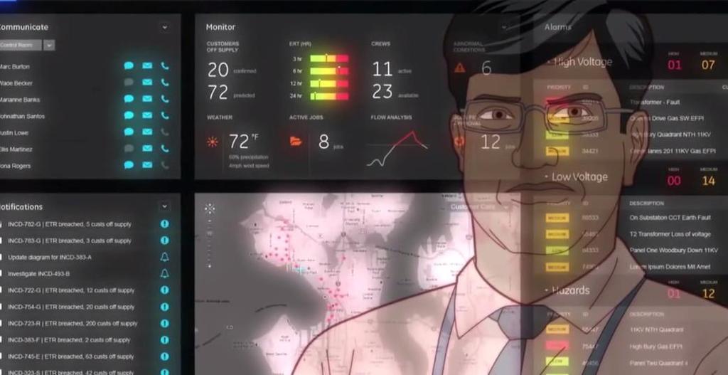
11 What is the DMS? A Distribution Management System is a system designed to monitor and control the entire distribution network efficiently and reliably The DMS provides: Real time view of system status Analysis of system conditions Detecting faults Recommended solutions to violations and faults


12 DMS modules SCADA DMS Map GIS Model DMS Model Distribution Power Flow FLISR Operators Feeder Reconfiguration

13 DMS Map DMS Map contains the operational network model, including connectivity and device modeling, and all user interface functions.

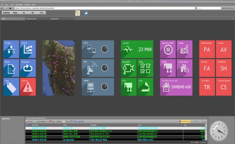
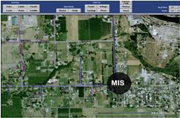
14 DMS Map


15 Fault Location Isolation and Service Restoration - FLISR FLISR is the real-time fault and switching analysis module within the DMS FLISR analyzes faults for possible locations and develops switching solutions to isolate the fault and restore customers.


16 Fault Location Isolation and Service Restoration - FLISR Automatically creating switching plans to isolate fault in the network. Reducing outage durations, and improving system reliability and customer service.


17 Distribution Power Flow - DPF DPF includes real-time calculations for power, voltage, current, and power factor. DPF helps the engineers to detect possible section overloads or high/low voltage issues before they cause an outage. DPF can be run in an offline Study Mode in order to simulate and analyse different system conditions


18
19 The Benefits Of The Integration


20 The Benefits of the integration For the Electrical departments : Control Department: Real time switching plans / switching orders and Visualization of GIS network within SCADA/DMS system.
21 The Benefits of the integration Planning Department: Network analysis with analysis tool. Maintenance Department: Tracking of faults in minimum time / fault management. All Departments: Electrical network tracing functionality : downstream and upstream network etc... New data Model design and validation rules for the GIS : as per the integration requirements ; new feature classes, subtypes, connectivity rules, etc... Updated and accurate data in the GIS : The GIS will be maintained daily/weekly to ensure the DMS information is as up to date as possible.
22 DMS-GIS Integration process


23 GIS Data Validations & Geodatabase Extraction GIS Database Geodatabase for DMS Purposes

24 High-Level Process Overview GIS DMS Integration Process GIS GIS Data Model with DMS requirements GIS Data Enhancements with QA/QC processes Rules & Processes for refining data for DMS fit GIS Data Integration Processes Extraction processes to File Geodatabase DMS DMS Import Processes DMS Validation rules of data for DMS use DMS Applications DMS Data
25 The End Thank You Any Questions??? Eng Anas Obeidat
Enterprise GIS to Support ADMS ESRI GeoConx EGUG 2016 Parag Parikh
 October 20, 2016 ESRI GeoConX Enterprise GIS to Support ADMS ESRI GeoConx EGUG 2016 Parag Parikh Parag.Parikh@us.abb.com Slide 1 WE Energies Overview Total accounts: 2,240,640 Electric accounts: 1,148,805
Integration of ArcFM UT with SCADA, SAP, MAXIMO and Network Calculation
 Integration of ArcFM UT with SCADA, SAP, MAXIMO and Network Calculation Peter Harabin (VSE) Martin Mydliar (ArcGEO) July 9, 2013 Esri International User Conference Agenda > Business/process part = WHAT
How Graphic Representations of Outages at Alabama Power Are Made Simple
 How Graphic Representations of Outages at Alabama Power Are Made Simple Presentation Overview This presentation will discuss the steps we took at Alabama Power using GIS to create a couple of different
Is Your Geodatabase Ready for Smart Grid? Ed Blair Telvent Utility Group
 Is Your Geodatabase Ready for Smart Grid? Ed Blair Telvent Utility Group You Can t Have a Smart Grid with Dumb Data, Jeffery R. Meyers Scope of the Discussion A Geodatabase-centric view of Smart Grid technologies
The Standard Infrastructure
 GISize! The Standard Infrastructure Management Interface for Wonderware Presenter Selim Birced GISize! Introduction 2 GISize! The Standard Infrastructure Management Interface A framework designed to: Helping
Steve Pietersen Office Telephone No
 Steve Pietersen Steve.Pieterson@durban.gov.za Office Telephone No. 031 311 8655 Overview Why geography matters The power of GIS EWS GIS water stats EWS GIS sanitation stats How to build a GIS system EWS
Construction in my Neighborhood - Communication with Stakeholder and Public -
 Construction in my Neighborhood - Communication with Stakeholder and Public - Presented by: Navneet Virk East Bay Municipal Utility District, Oakland, CA 0 Mission at EBMUD To manage the natural resources
Enabling Success in Enterprise Asset Management: Case Study for Developing and Integrating GIS with CMMS for a Large WWTP
 Enabling Success in Enterprise Asset Management: Case Study for Developing and Integrating GIS with CMMS for a Large WWTP Allison Blake, P.E. 1*, Matthew Jalbert, P.E. 2, Julia J. Hunt, P.E. 2, Mazen Kawasmi,
PUB NLH 185 Island Interconnected System Supply Issues and Power Outages Page 1 of 9
 PUB NLH 1 Page 1 of 1 Q. Provide Hydro s list of outage cause codes and indicate how troublemen are managed and trained to properly use the codes. Explain the method used to report outage causes. A. Hydro
USING GIS IN WATER SUPPLY AND SEWER MODELLING AND MANAGEMENT
 USING GIS IN WATER SUPPLY AND SEWER MODELLING AND MANAGEMENT HENRIETTE TAMAŠAUSKAS*, L.C. LARSEN, O. MARK DHI Water and Environment, Agern Allé 5 2970 Hørsholm, Denmark *Corresponding author, e-mail: htt@dhigroup.com
What s New in Collector for ArcGIS (Aurora)
") What s New in Collector for ArcGIS (Aurora) Derek Law (dlaw@esri.com) Esri Apps Product Management @GIS_Bandit Oct 10 th, 2018 Agenda Product overview Use cases Preparing data for Collector for ArcGIS
What s New in Collector for ArcGIS (Aurora) Derek Law (dlaw@esri.com) Esri Apps Product Management @GIS_Bandit Oct 10 th, 2018 Agenda Product overview Use cases Preparing data for Collector for ArcGIS
ArcGIS for Local Government
 Wednesday, June 29th ArcGIS for Local Government Dan Rose, GIS Analyst WaterOne IT/GIS Agenda / Talking Points What is the LGIM? WaterOne s GIS and LGIM background Our geodatabase redesign Our strategies
Administering your Enterprise Geodatabase using Python. Jill Penney
 Administering your Enterprise Geodatabase using Python Jill Penney Assumptions Basic knowledge of python Basic knowledge enterprise geodatabases and workflows You want code Please turn off or silence cell
DP Project Development Pvt. Ltd.
 Dear Sir/Madam, Greetings!!! Thanks for contacting DP Project Development for your training requirement. DP Project Development is leading professional training provider in GIS technologies and GIS application
Performing Advanced Cartography with Esri Production Mapping
 Esri International User Conference San Diego, California Technical Workshops July 25, 2012 Performing Advanced Cartography with Esri Production Mapping Tania Pal & Madhura Phaterpekar Agenda Outline generic
The File Geodatabase API. Craig Gillgrass Lance Shipman
 The File Geodatabase API Craig Gillgrass Lance Shipman Schedule Cell phones and pagers Please complete the session survey we take your feedback very seriously! Overview File Geodatabase API - Introduction
Geodatabase An Overview
 Federal GIS Conference February 9 10, 2015 Washington, DC Geodatabase An Overview Ralph Denkenberger - esri Session Path The Geodatabase - What is it? - Why use it? - What types are there? Inside the Geodatabase
Digital Wetlands. Bringing the Field into the Office Through GIS
 Digital Wetlands Bringing the Field into the Office Through GIS Maryland Department of the Environment Wetlands and Waterways Program MDE's Wetlands and Waterways Program seeks to conserve valuable aquatic
A new FMECA model for reliability computations in electrical distribution systems
 Proceedings of the 6th WSEAS/IASME Int. Conf. on Electric Power Systems, High Voltages, Electric Machines, Tenerife, Spain, December 6-8, 2006 A new FMECA model for reliability computations in electrical
Power System Security. S. Chakrabarti
 Power System Security S. Chakrabarti Outline Introduction Major components of security assessment On-line security assessment Tools for contingency analysis DC power flow Linear sensitivity factors Line
Presentation On GIS. Tarun Batra HoG-GIS Dhruba Banerjee - Team lead (Technical)
") Presentation On GIS Tarun Batra HoG-GIS Dhruba Banerjee - Team lead (Technical) Presentation Outline What is GIS? TPDDL s GIS Journey Component of GIS Project Phase of GIS GIS Applications GIS Landscape
Presentation On GIS Tarun Batra HoG-GIS Dhruba Banerjee - Team lead (Technical) Presentation Outline What is GIS? TPDDL s GIS Journey Component of GIS Project Phase of GIS GIS Applications GIS Landscape
Geodatabase An Introduction
 2013 Esri International User Conference July 8 12, 2013 San Diego, California Technical Workshop Geodatabase An Introduction David Crawford and Jonathan Murphy Session Path The Geodatabase What is it?
INTRODUCTION TO ARCGIS Version 10.*
 Week 3 INTRODUCTION TO ARCGIS Version 10.* topics of the week Overview of ArcGIS Using ArcCatalog Overview of ArcGIS Desktop ArcGIS Overview Scalable desktop applications ArcView ArcEditor ArcInfo ArcGIS
Reliability Assessment Electric Utility Mapping. Maged Yackoub Eva Szatmari Veridian Connections Toronto, October 2015
 Reliability Assessment Electric Utility Mapping Maged Yackoub Eva Szatmari Veridian Connections Toronto, October 2015 Agenda Introduction About Veridian Connections Veridian s GIS platform Reliability
Applications of GIS in Electrical Power System
 Applications of GIS in Electrical Power System Abdulrahman M. AL-Sakkaf 201102310 CRP 514 May 2013 Dr. Baqer M. AL-Ramadan Abstract GIS has been widely used in various areas and disciplines. This paper
Road to GIS, PSE s past, present and future
 Road to GIS, PSE s past, present and future PSE Gas Mapping History 1840 Early 1900 s Gas piping was captured in Field Books which were than converted onto Mylar maps using Pen and Ink. 1955 Washington
Introduction to Portal for ArcGIS. Hao LEE November 12, 2015
 Introduction to Portal for ArcGIS Hao LEE November 12, 2015 Agenda Web GIS pattern Product overview Installation and deployment Security and groups Configuration options Portal for ArcGIS + ArcGIS for
Peterborough Distribution Inc Ashburnham Drive, PO Box 4125, Station Main Peterborough ON K9J 6Z5
 Peterborough Distribution Inc. 1867 Ashburnham Drive, PO Box 4125, Station Main Peterborough ON K9J 6Z5 November 15, 2017 Ontario Energy Board PO Box 2319 27 th Floor, 2300 Yonge St Toronto ON M4P 1E4
PI SERVER 2012 Do. More. Faster. Now! Copyr i g h t 2012 O S Is o f t, L L C. 1
 PI SERVER 2012 Do. More. Faster. Now! Copyr i g h t 2012 O S Is o f t, L L C. 1 AUGUST 7, 2007 APRIL 14, 2010 APRIL 24, 2012 Copyr i g h t 2012 O S Is o f t, L L C. 2 PI Data Archive Security PI Asset
Geodatabase Programming with Python John Yaist
 Geodatabase Programming with Python John Yaist DevSummit DC February 26, 2016 Washington, DC Target Audience: Assumptions Basic knowledge of Python Basic knowledge of Enterprise Geodatabase and workflows
BVES Annual Reliability Public Presentation 2016 Performance
 BVES Annual Reliability Public Presentation 2016 Performance December 13, 2017 Agenda Company Overview What is Electric Utility Reliability? Requirements & Definitions Reliability Indices 2016 Reliability
The Story of a Campus Map:
 The Story of a Campus Map: ACCESSIBILITY, GIS, AND CAMPUS PARTNERS Matthew Tafoya, GIS Manager, Facility Services Lauren Copeland-Glenn, AAP/ADA Coordinator, Co-Chair for the Commission on Disability Access
Introduction to Portal for ArcGIS
 Introduction to Portal for ArcGIS Derek Law Product Management March 10 th, 2015 Esri Developer Summit 2015 Agenda Web GIS pattern Product overview Installation and deployment Security and groups Configuration
Chapter 6: Conclusion
 Chapter 6: Conclusion As stated in Chapter 1, the aim of this study is to determine to what extent GIS software can be implemented in order to manage, analyze and visually illustrate an IT-network between
Geodatabase Programming with Python
 DevSummit DC February 11, 2015 Washington, DC Geodatabase Programming with Python Craig Gillgrass Assumptions Basic knowledge of python Basic knowledge enterprise geodatabases and workflows Please turn
Geodatabase An Introduction
 Federal GIS Conference 2014 February 10 11, 2014 Washington DC Geodatabase An Introduction Ralph Denkenberger esri Session Path The Geodatabase - What is it? - Why use it? - What types are there? Inside
Commissioning and Testing of AVR and PSS
 Commissioning and Testing of AVR and PSS Excitation System Upgrade and commissioning challenges Vetti Bala Principal C&I Engineer G E N E S I S E N E R G Y L I M I T E D Contents Asset Testing - AVR AVR
APPLICATION OF GIS IN ELECTRICAL DISTRIBUTION NETWORK SYSTEM
 See discussions, stats, and author profiles for this publication at: https://www.researchgate.net/publication/305263658 APPLICATION OF GIS IN ELECTRICAL DISTRIBUTION NETWORK SYSTEM Article October 2015
Identifying Trends in Exclusions and Feature Revisions to Promote Better Recon. Surface Water Status Monitoring Network
 Identifying Trends in Exclusions and Feature Revisions to Promote Better Recon Surface Water Status Monitoring Network Andy Woeber GIS Analyst Watershed Monitoring Section FDEP Tallahassee Surface water
Wind power and management of the electric system. EWEA Wind Power Forecasting 2015 Leuven, BELGIUM - 02/10/2015
 Wind power and management of the electric system EWEA Wind Power Forecasting 2015 Leuven, BELGIUM - 02/10/2015 HOW WIND ENERGY IS TAKEN INTO ACCOUNT WHEN MANAGING ELECTRICITY TRANSMISSION SYSTEM IN FRANCE?
Your Perfect 3D World (BIM and GIS Integrated)
") Your Perfect 3D World (BIM and GIS Integrated) June 2015 Larisa Kruger Background Larisa Kruger- Enterprise GIS Manager FITS- Facilities Information Technology Services 2 years (GIS for 15) 2 FTE, 4 students
Your Perfect 3D World (BIM and GIS Integrated) June 2015 Larisa Kruger Background Larisa Kruger- Enterprise GIS Manager FITS- Facilities Information Technology Services 2 years (GIS for 15) 2 FTE, 4 students
Minnesota Public Utilities Commission Staff Briefing Papers
 Minnesota Public Utilities Commission Staff Briefing Papers Meeting Date: March 7, 2006 Agenda Item # *10 Company: Docket Nos. Minnesota Power Northwestern Wisconsin Electric Company Interstate Power and
SIMATIC Ident Industrial Identification Systems
 Related catalogs SIMATIC Ident Industrial Identification Systems Catalog ID 10 2012 Introduction System overview SIMATIC Ident 1 RFID systems for the HF frequency range SIMATIC RF200 SIMATIC RF300 MOBY
Applications of GIS in Electrical Power System. Dr. Baqer AL-Ramadan Abdulrahman Al-Sakkaf
 Applications of GIS in Electrical Power System Dr. Baqer AL-Ramadan Abdulrahman Al-Sakkaf OUTLINES: Objective Importance of GIS GIS data development Application of GIS Findings Conclusions and Recommendations
Geodatabase: Best Practices. Robert LeClair, Senior Instructor
 Geodatabase: Best Practices Robert LeClair, Senior Instructor Agenda Geodatabase Creation Data Ownership Data Model Data Configuration Geodatabase Behaviors Data Validation Extending Performance Geodatabase
GIS implementation in BESCOM
 GIS implementation in BESCOM Muthulakshmi K B DGM-ICT&MIS, BESCOM Slide No 1 Contents Introduction Implementation Challenges Solution Status Way forward Slide No 2 Introduction GIS Geographical Information
Leveraging GIS data and tools for maintaining hydraulic sewer models
 Leveraging GIS data and tools for maintaining hydraulic sewer models Ben Gamble & Joseph Koran Metropolitan Sewer District of Greater Cincinnati Carl C. Chan & Michael York CDM Smith Ben Gamble Senior
Geodatabase Replication for Utilities Tom DeWitte Solution Architect ESRI Utilities Team
 Geodatabase Replication for Utilities Tom DeWitte Solution Architect ESRI Utilities Team 1 Common Data Management Issues for Utilities Utilities are a distributed organization with the need to maintain
Integrating ArcGIS Server and Flex: Highlighting the Trees in Washington, DC. Holli Howard and Mike Alonzo Casey Trees Washington, DC
 Integrating ArcGIS Server and Flex: Highlighting the Trees in Washington, DC Holli Howard and Mike Alonzo Casey Trees Washington, DC Presentation overview Casey Trees Our ESRI partnership: The Casey Trees
Creation and modification of a geological model Program: Stratigraphy
 Engineering manual No. 39 Updated: 11/2018 Creation and modification of a geological model Program: Stratigraphy File: Demo_manual_39.gsg Introduction The aim of this engineering manual is to explain the
Administering Your Enterprise Geodatabase using Python. Gerhard Trichtl
 Administering Your Enterprise Geodatabase using Python Gerhard Trichtl What is the Geodatabase What is the Geodatabase A physical store of geographic data - Scalable storage model supported on different
Data Structures & Database Queries in GIS
 Data Structures & Database Queries in GIS Objective In this lab we will show you how to use ArcGIS for analysis of digital elevation models (DEM s), in relationship to Rocky Mountain bighorn sheep (Ovis
LRS Task Force June 13, REVISION HISTORY
 North Carolina Department of Transportation Geographic Information Systems (GIS) Unit LINEAR REFERENCING SYSTEM (LRS) PROJECT DEFINITION Version 1.0 REVISION HISTORY Date Document Manager Revision Purpose
Project Charter. $58,000 See attached budget report. shapefile to track poles and pole attachments. Poles are defined as a support structure on
 Project Charter Title: Pole and Pole Attachment Geodatabase Design Sponsor: City of Philadelphia Streets Department Date: May 10, 2006 Estimated Start Date: June 1, 2006 Projected Finish Date: October
Is Your GIS Ready For Grid Modernization? A State-of-the Industry Report
 Is Your GIS Ready For Grid Modernization? A State-of-the Industry Report Is Your GIS Ready For Grid Modernization? Survey Overview In the first quarter of 2019, Energy Acuity conducted a grid modernization
Understanding the Impact and Value of Esri s Utility Network for Network Management
 Understanding the Impact and Value of Esri s Utility Network for Network Management Mike Chiasson, Pasadena Water and Power (PWP) Anil Jayavarapu, Avineon, Inc. Esri GeoConX 2017 Presentation Outline Pasadena
Enabling the Image Analyst (IA) to use the geodatabase
 to use the geodatabase") Enabling the Image Analyst (IA) to use the geodatabase Rick Racine, BAE Systems, Reston, VA Stewart Walker, BAE Systems, San Diego, CA 2008 ESRI Federal User Conference, Washington, D.C., 21 February 2610020508
Enabling the Image Analyst (IA) to use the geodatabase Rick Racine, BAE Systems, Reston, VA Stewart Walker, BAE Systems, San Diego, CA 2008 ESRI Federal User Conference, Washington, D.C., 21 February 2610020508
Maryland Transit Administration (MTA) Bus Accident Mapping and Analysis Application
 Bus Accident Mapping and Analysis Application") Maryland Transit Administration (MTA) Bus Accident Mapping and Analysis Application Ralign Wells, MTA Administrator Bernadette Bridges, MTA Chief Safety Officer Office of Safety, Quality Assurance, and
Maryland Transit Administration (MTA) Bus Accident Mapping and Analysis Application Ralign Wells, MTA Administrator Bernadette Bridges, MTA Chief Safety Officer Office of Safety, Quality Assurance, and
DISTRIBUTION SYSTEM OPTIMISATION
 Politecnico di Torino Dipartimento di Ingegneria Elettrica DISTRIBUTION SYSTEM OPTIMISATION Prof. Gianfranco Chicco Lecture at the Technical University Gh. Asachi, Iaşi, Romania 26 October 2010 Outline
Improving Data Quality and. Productivity in Public Works Mobile GIS: Do you GO! Sync? Robert E. Thomas, GISP GIS Specialist City of Woodland
 Improving Data Quality and Increasing Field Crew Productivity in Public Works Mobile GIS: Do you GO! Sync? Robert E. Thomas, GISP GIS Specialist City of Woodland Overview-City of Woodland Woodland is the
Maryland Transit Administration (MTA) Bus Accident Mapping and Analysis Application
 Bus Accident Mapping and Analysis Application") Maryland Transit Administration (MTA) Bus Accident Mapping and Analysis Application Ralign Wells, MTA Administrator Bernadette Bridges, MTA Chief Safety Officer Office of Safety, Quality Assurance, and
Maryland Transit Administration (MTA) Bus Accident Mapping and Analysis Application Ralign Wells, MTA Administrator Bernadette Bridges, MTA Chief Safety Officer Office of Safety, Quality Assurance, and
Smart Grid Opportunities Being Pursued. Stephanie Hamilton Brookhaven National Laboratory June 5, 2013
 Smart Grid Opportunities Being Pursued Stephanie Hamilton Brookhaven National Laboratory June 5, 2013 OUR DREAM!! BNL s Smarter Electric Grid Research, Innovation, Development. Demonstration, Deployment
Tools for GASB34 Implementation GIS/GPS
 Tools for GASB34 Implementation GIS/GPS Geographic Technologies Group February, 2002 Curtis Hinton Goldsboro, NC Augusta, GA Raleigh, NC Boynton Beach, FL Houston, TX http://www.geotg.com 919-759 759-92149214
Enterprise Linear Referencing at the NYS Department of Transportation
 Enterprise Linear Referencing at the NYS Department of Transportation One Highway Network to Support Many Business Processes May 9, 2018 May 9, 2018 2 Agenda An overview of Linear Referencing How NYSDOT
CLICK HERE TO KNOW MORE
 CLICK HERE TO KNOW MORE Integrating GIS data for Water Distribution Modeling Case Study: General Directorate of Water Eng. Atif Karrani - GIS Manager karrani@sewa.gov.ae Agenda Introduction Enterprise
Review of. Florida s Investor-Owned Electric Utilities Service Reliability reports. State of Florida
 Review of Florida s Investor-Owned Electric Utilities 2 0 1 2 Service Reliability reports N O V E M B E R 2 0 1 3 State of Florida Florida Public Service Commission Division of ENGINEERING Review of Florida
Robert D. Borchert GIS Technician
 QA/QC: AM/FM: A Checklist Confirmed for fit Quality Methods and Control Actions Robert D. Borchert GIS Technician This just goes to show that QA/QC is important. Robert D. Borchert GIS Technician Did you
Road Ahead: Linear Referencing and UPDM
 Road Ahead: Linear Referencing and UPDM Esri European Petroleum GIS Conference November 7, 2014 Congress Centre, London Your Work Making a Difference ArcGIS Is Evolving Your GIS Is Becoming Part of an
SAIT & FortisAlberta Forge a Partnership to put New Ideas on the Map
 SAIT & FortisAlberta Forge a Partnership to put New Ideas on the Map Presented by: - Jamie Johnston-Stewart, SAIT Instructor, SAIT - Sarah Cameron, Supervisor Data Integrity & GIS, FortisAlberta - Liam
A GIS Tool for Modelling and Visualizing Sustainability Indicators Across Three Regions of Ireland
 International Conference on Whole Life Urban Sustainability and its Assessment M. Horner, C. Hardcastle, A. Price, J. Bebbington (Eds) Glasgow, 2007 A GIS Tool for Modelling and Visualizing Sustainability
Control Strategies for Microgrids
 Control Strategies for Microgrids Ali Mehrizi-Sani Assistant Professor School of Electrical Engineering and Computer Science Washington State University Graz University of Technology Thursday, November
Role of Synchronized Measurements In Operation of Smart Grids
 Role of Synchronized Measurements In Operation of Smart Grids Ali Abur Electrical and Computer Engineering Department Northeastern University Boston, Massachusetts Boston University CISE Seminar November
Enabling Web GIS. Dal Hunter Jeff Shaner
 Enabling Web GIS Dal Hunter Jeff Shaner Enabling Web GIS In Your Infrastructure Agenda Quick Overview Web GIS Deployment Server GIS Deployment Security and Identity Management Web GIS Operations Web GIS
CAD: Introduction to using CAD Data in ArcGIS. Kyle Williams & Jeff Reinhart
 CAD: Introduction to using CAD Data in ArcGIS Kyle Williams & Jeff Reinhart What we will accomplish today Overview of ArcGIS CAD Support Georeferencing CAD data for ArcGIS How Mapping Specification for
Overload Relays. SIRIUS 3RU1 Thermal Overload Relays. 3RU11 for standard applications. 5/46 Siemens LV 1 AO 2011
 SIRIUS 3RU1 Thermal Overview 1 2 7 3 4 6 "Increased safety" type of EEx e according to ATEX directive 94/9/EC The 3RU11 thermal overload relays are suitable for the overload of explosion-proof motors with
Geodatabase Best Practices. Dave Crawford Erik Hoel
 Geodatabase Best Practices Dave Crawford Erik Hoel Geodatabase best practices - outline Geodatabase creation Data ownership Data model Data configuration Geodatabase behaviors Data integrity and validation
Smart Data Collection and Real-time Digital Cartography
 Smart Data Collection and Real-time Digital Cartography Yuji Murayama and Ko Ko Lwin Division of Spatial Information Science Faculty of Life and Environmental Sciences University of Tsukuba IGU 2013 1
Incorporating ArcGIS Pro in your Curriculum
 AAG, Boston 2017 April 5, 2017 Incorporating ArcGIS Pro in your Curriculum Geri Miller Agenda Concerns Acknowledged Learning curve ArcGIS Pro does not have all the tools (perception) Licensing and offline
Windchill Quality Solutions 2011 (formerly Relex 2011) Curriculum Guide
 Curriculum Guide") Windchill Quality Solutions 2011 (formerly Relex 2011) Curriculum Guide Web Based Curriculum Guide Update to Windchill Quality Solutions (Formerly Relex 2011) Windchill Quality Solutions (Formerly Relex
Windchill Quality Solutions 2011 (formerly Relex 2011) Curriculum Guide Web Based Curriculum Guide Update to Windchill Quality Solutions (Formerly Relex 2011) Windchill Quality Solutions (Formerly Relex
Mapping Utilities with Mobile GIS Applications
 Mapping Utilities with Mobile GIS Applications Kristy M. Capobianco Reynolds, Smith and Hills, Inc. GIS Analyst Kristy.Capobianco@rsandh.com (904) 256-2251 2007 ESRI Southeast User Group Conference May
Introduction to ArcGIS Maps for Office. Greg Ponto Scott Ball
 Introduction to ArcGIS Maps for Office Greg Ponto Scott Ball Agenda What is Maps for Office? Platform overview What are Apps for the Office? ArcGIS Maps for Office features - Visualization - Geoenrichment
Implementation of GISystems in the Land Acquisition Process and Road Maintenance. Immaculate Katutsi Uganda National Roads Authority
 Implementation of GISystems in the Land Acquisition Process and Road Maintenance Immaculate Katutsi Uganda National Roads Authority Stage 1 Stage 2 Stage 3 2 The Road construction process/ Project flow
Electric Power Supply Network Management Using GIS Solution
 Electric Power Supply Network Management Using GIS Solution A.Balamurugan 1, Saravanaraja.K 2, G.Ramakrishnaprabu 3 Asst. Professor, Department of EEE, VMKV Engineering College, Salem, Tamilnadu, India
DISTRIBUTION SYSTEM ELECTRIC INFRASTRUCTURE RELIABILITY PERFORMANCE INDICATORS
 EB-- Exhibit D Page of DISTRIBUTION SYSTEM ELECTRIC INFRASTRUCTURE RELIABILITY PERFORMANCE INDICATORS FIVE-YEAR HISTORICAL RELIABILITY PERFORMANCE THESL tracks System Average Interruption Frequency Index
Lecture 2. Introduction to ESRI s ArcGIS Desktop and ArcMap
 Lecture 2 Introduction to ESRI s ArcGIS Desktop and ArcMap Outline ESRI What is ArcGIS? ArcGIS Desktop ArcMap Overview Views Layers Attribute Tables Help! Scale Tips and Tricks ESRI Environmental Systems
file://q:\report1\greenatlasfinalreportindex.html
 Page 1 of 8 Quick Links WATER MANAGEMENT INTERNSHIP USDA HIS GRANT FUNDED FINAL PROJECT REPORT SUBMITTED BY MELISSA QUINTANA 11/07/07-03/24/08 Summary Provided is an assessment of my accomplishments for
Advanced GIS Applications in Transit
 Advanced GIS Applications in Transit Case Studies of Five Large Transit Agencies presented to GIS in Transit Conference presented by John Sutton, Ph.D. Cambridge Systematics, Inc. November 1, 2005 Transportation
GIS at JLAB. T. Larrieu Jefferson Lab, Newport News, VA 23606, USA. Controls Group. October 2006 PCaPAC
 GIS at JLAB T. Larrieu Jefferson Lab, Newport News, VA 23606, USA October 2006 PCaPAC Jefferson Lab has a Large and Complex Infrastructure CEBAF ( 24/7 electron utility ) 7 km of beamline 2000+ magnets
Lecture 11. Data Standards and Quality & New Developments in GIS
 Lecture 11 Data Standards and Quality & New Developments in GIS Lecture 11: Outline I. Data Standards and Quality 1. Types of Spatial Data Standards 2. Data Accuracy II. New Developments/The Future of
Lecture 12. Data Standards and Quality & New Developments in GIS
 Lecture 12 Data Standards and Quality & New Developments in GIS Lecture 12: Outline I. Data Standards and Quality 1. Types of Spatial Data Standards 2. Data Accuracy 3. III. Documenting Spatial Data Accuracy
GEOGRAPHIC INFORMATION SYSTEMS AND IT SOLUTIONS FOR THE ENVIRONMENT
 GEOGRAPHIC INFORMATION SYSTEMS AND IT SOLUTIONS FOR THE ENVIRONMENT Mission We focus on Solutions is a worldwide operating business offering Geographic Information Systems and IT solutions to assist environmental
IMPERIAL COUNTY PLANNING AND DEVELOPMENT
 IMPERIAL COUNTY PLANNING AND DEVELOPMENT GEODATABASE USER MANUAL FOR COUNTY BUSINESS DEVELOPMENT GIS June 2010 Prepared for: Prepared by: County of Imperial Planning and Development 801 Main Street El
Electric Distribution Storm Hardening Initiatives. Paul V. Stergiou Distribution Engineering October 14 th, 2015
 Consolidated Edison Company of New York, Inc. Electric Distribution Storm Hardening Initiatives Paul V. Stergiou Distribution Engineering October 14 th, 2015 Energy For New York City And Westchester 3.3
An easy-to-use application that lets end users prepare and deploy background maps to your Carmenta based applications.
 Introducing Carmenta Map Builder An easy-to-use application that lets end users prepare and deploy background maps to your Carmenta based applications. Carmenta s geospatial technology is known for its
Reliability Assessment of Radial distribution system incorporating weather effects
 International Journal of Engineering Research and Development e-issn: 2278-067X, p-issn: 2278-800X, www.ijerd.com Volume 6, Issue 7 (pril 2013), PP. 45-51 Reliability ssessment of Radial distribution system
Assessment of Physical status and Irrigation potential of Canals using ArcPy
 Assessment of Physical status and Irrigation potential of Canals using ArcPy Ekta Gupta 1, R.N. Sankhua 2 1 JRF, CES, Indian Institute of Science, Bangalore 2 Director, National Water Academy, Pune Abstract:
That s Why We Did That! A MicroStation to ArcGIS Conversion Story
 GIS- April 2016 That s Why We Did That! A MicroStation to ArcGIS Conversion Story Michael Herrmann (mherrmann1@ncdot.gov) NC : County Road and Bridge Maps 3 Lenoir County Bridge Map Back In the Old Days.
White Rock Tree Management Silverlight Application. Presented by: Boris Zanic, GIS Specialist Ying Lin, GIS/WEB Technician
 White Rock Tree Management Silverlight Application Presented by: Boris Zanic, GIS Specialist Ying Lin, GIS/WEB Technician Land Area 5.28 square km Population in 2011 19,339 Population density 3,500 Median
Linear Referencing Systems (LRS) Support for Municipal Asset Management Systems
 Support for Municipal Asset Management Systems") Linear Referencing Systems (LRS) Support for Municipal Asset Management Systems Esri Canada Infrastructure Asset Management Leadership Forum November 1, 2017 Toronto, ON David Loukes, P. Eng., FEC Andy
Linear Referencing Systems (LRS) Support for Municipal Asset Management Systems Esri Canada Infrastructure Asset Management Leadership Forum November 1, 2017 Toronto, ON David Loukes, P. Eng., FEC Andy
Optimizing work processes by using GIS in the ASFINAG. Peter Aubrecht ASFINAG Service GmbH, AUSTRIA EUC Croatia, Split 15 th October 2014
 Optimizing work processes by using GIS in the ASFINAG Peter Aubrecht ASFINAG Service GmbH, AUSTRIA EUC Croatia, Split 15 th October 2014 AGENDA The ASFINAG Group: Organisation and Tasks The ASFINAG Road