Tools for GASB34 Implementation GIS/GPS
|
|
|
- Nathan Charles
- 6 years ago
- Views:
Transcription
1 Tools for GASB34 Implementation GIS/GPS Geographic Technologies Group February, 2002 Curtis Hinton Goldsboro, NC Augusta, GA Raleigh, NC Boynton Beach, FL Houston, TX
2 Topics GIS Overview Database Design Available Tools Pearland, TX Example Using ArcGIS Other GIS Tools
3
4 Maps + Databases = Digital Model of City Ownership Streets and Addresses Structure Values Water Sewer Storm Water Signs
5 Topics GIS Overview Database Design Available Tools Pearland, TX Example Using ArcGIS Other GIS Tools
6 Database Design Database Design Methodology Business Process Requirements Analysis Logical Design Physical Design Implementation (Pearland, TX) Design Components Establish framework of data to be converted Should be complete before conversion
7 Database Design Test of goodness of a database design includes The quality of representation of the data model Its implementation within the target technology Only true measurement of success Does it meet the users needs
8 Database Design Does it meet the users needs? Has to meet these two criteria: Does the model contain correct representations of all the important aspects of reality that a user must know about in order to solve their business problem? Boynton Beach, FL Does the database avoid including a lot of extra stuff that slows down getting the answer? Ex. Horry Co. SC

9 TAX PARCELS Coverage Type: Tax Parcels Coverage Feature Class(es): Polygon Data Source: Pitt County Utilized By: All Status: Updated monthly Description: Tax parcels Recommended Attributes: Items, Codes and Values: ITEM NAME IN WIDTH OUT WIDTH TYPE DECIMAL DESCRIPTION TAG C None There is commonly a tag or parid that is used to tie the geographic coverage to the tax assessment data. PIN C None A parcel identification number. Mapsheet 6 6 C None The Mapsheet the parcel was obtained from. Ownername C None The name of the parcel s s owner. Mail_Addr C None Owner s s Mailing Address (Street) Mail_City C None Owners s Mailing Address (City) Mail_Zip 5 5 C None Owner s s Mailing Address (Zip Code) Prop_Addr C None Street Address of the actual parcel. Prop_City C None City the parcel resides in. Prop_Zip 5 5 I None Zip Code of the parcel Book 5 5 I None The deed book the parcel is recorded in. Page 5 5 I None The page book the parcel is recorded on. Land_Value I None The dollar value of the land Building_Value I None The dollar value of the building. Misc_buildval I None The dollar value of any miscellaneous buildings Acreage 8 12 F 2 Acreage Sq_ft 5 5 I None Square foot of the building
10 GIS now The Evolution of GIS GIS is mainstream not esoteric Demands from end users ease of use consistent user experience Demands from developers for standards Development environments Mainstream hardware platforms Standardized data storage
11 Mainstream GIS Only through use of highly scalable data stores can this be achieved Pros Power Users Public/Casual Millions Cost per user
12 Topics GIS Overview Database Design Available Tools Pearland, TX Example Using ArcGIS Other GIS Tools
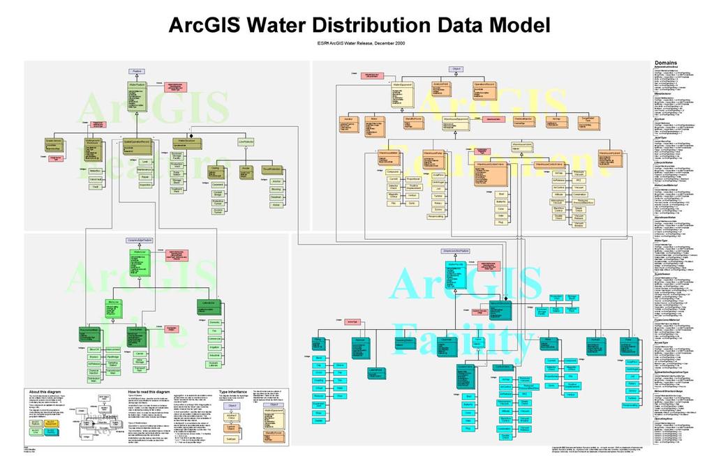
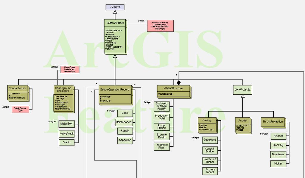
13 Benefits of ArcGIS 8.1 Geodatabase and the Water Distribution and Sanitary Sewer Distribution Data Models ArcGIS 8.1 Rules-based Object-oriented All data stored in one database Data Models Agreed-upon definitions of feature classes Business logic - rules for editing, feature relationships Symbology that pertains to water and wastewater networks
14

15 Point Features

16 Linear Features
17 Non-Network Features
18 Topics GIS Overview Database Design Available Tools Pearland, TX Example Using ArcGIS Other GIS Tools
19 Water Distribution System Linear Features

20 Sanitary Sewer Distribution System Linear Features

21 Sanitary Sewer Network Flow

22 Sanitary Sewer Overlaying Aerial Photography

23 Water Distribution System All Features

24 Feature Identify Fitting (Subtype: Tee)

25 Report Generation Fire Hydrant Maintenance Records City of Pearland Fire Hydrants

26 ArcCatalog Feature Preview: Geography

27 ArcCatalog Feature Preview: Table

28 ArcCatalog Feature Preview: Metadata
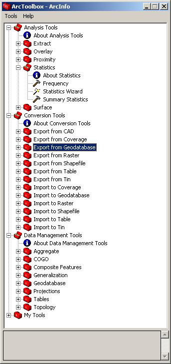
29 ArcToolbox
30 Topics GIS Overview Database Design New School Available Tools Pearland, TX Example Using ArcGIS Other GIS Tools
31
32
33
34
35 Other Key Issues Show success quickly and make it easy to use Use Existing Data - Think Your Data Billing Complaints Asset Information Work Orders Live Link to ODBC Compliant Database New model As Important - Data Entry Application Work Orders
36 Thank you
37 For More Information on GIS Solutions for GASB34 Contact: Geographic Technologies Group February, 2002 Curtis Hinton Goldsboro, NC Augusta, GA Raleigh, NC Boynton Beach, FL Houston, TX
GIS Quick Facts. CIVL 1101 GIS Quick Facts 1/5.
 CIVL 1101 1/5 What is GIS? Geographic Information Systems (GIS) provide a platform for displaying and analyzing spatial data. GIS systems allow you to view multiple layers of data simultaneously. GIS is
Steve Pietersen Office Telephone No
 Steve Pietersen Steve.Pieterson@durban.gov.za Office Telephone No. 031 311 8655 Overview Why geography matters The power of GIS EWS GIS water stats EWS GIS sanitation stats How to build a GIS system EWS
NR402 GIS Applications in Natural Resources
 NR402 GIS Applications in Natural Resources Lesson 1 Introduction to GIS Eva Strand, University of Idaho Map of the Pacific Northwest from http://www.or.blm.gov/gis/ Welcome to NR402 GIS Applications in
GIS Geographical Information Systems. GIS Management
 GIS Geographical Information Systems GIS Management Difficulties on establishing a GIS Funding GIS Determining Project Standards Data Gathering Map Development Recruiting GIS Professionals Educating Staff
USING GIS IN WATER SUPPLY AND SEWER MODELLING AND MANAGEMENT
 USING GIS IN WATER SUPPLY AND SEWER MODELLING AND MANAGEMENT HENRIETTE TAMAŠAUSKAS*, L.C. LARSEN, O. MARK DHI Water and Environment, Agern Allé 5 2970 Hørsholm, Denmark *Corresponding author, e-mail: htt@dhigroup.com
MAPPS 2012 Geospatial Products and Services Excellence Awards Awards Entry Form
 MAPPS 2012 Geospatial Products and Services Excellence Awards 2012 Awards Entry Form Please include a copy of this document with the project/product submission Entry Information Submission Number: 1741558
Cobb County GIS: Beyond the Map
 Cobb County GIS: Beyond the Map Charles Fail Tim Scharff Cobb County GIS SERUG 2008 1 Topics Cobb GIS Overview The Early Years Enterprise GIS Transition Putting It Together Looking Ahead SERUG 2008 2 Cobb
KING GEORGE COUNTY DEPARTMENT OF COMMUNITY DEVELOPMENT
 GIS REPORT 2016 KING GEORGE COUNTY DEPARTMENT OF COMMUNITY DEVELOPMENT Background The GIS (Geographic Information System) coordinator was hired in 2001 to develop a GIS for King George County. Prior to
EEOS 381 -Spatial Databases and GIS Applications
 EEOS 381 -Spatial Databases and GIS Applications Lecture 5 Geodatabases What is a Geodatabase? Geographic Database ESRI-coined term A standard RDBMS that stores and manages geographic data A modern object-relational
Information. Information Technology. Geographic. Services (GIS) 119 W Indiana Ave Deland, FL 32720
 119 W Indiana Ave Deland, FL 32720") Information Technology Geographic Information Services (GIS) 119 W Indiana Ave Deland, FL 32720 A GIS consists of 5 primary components: Hardware Software People Data Methods or Business Processes --- Hardware
Information Technology Geographic Information Services (GIS) 119 W Indiana Ave Deland, FL 32720 A GIS consists of 5 primary components: Hardware Software People Data Methods or Business Processes --- Hardware
INTRODUCTION TO ARCGIS Version 10.*
 Week 3 INTRODUCTION TO ARCGIS Version 10.* topics of the week Overview of ArcGIS Using ArcCatalog Overview of ArcGIS Desktop ArcGIS Overview Scalable desktop applications ArcView ArcEditor ArcInfo ArcGIS
GIS. in the City of Lewiston Maine
 GIS in the City of Lewiston Maine The purpose of this slideshow is to provide an overview of the city GIS and how it is used, maintained and accessed in-house as well as by the public. Please simply hit
Geodatabases and ArcCatalog
 Geodatabases and ArcCatalog Prepared by Francisco Olivera, Ph.D. and Srikanth Koka Department of Civil Engineering Texas A&M University February 2004 Contents Brief Overview of Geodatabases Goals of the
Course overview. Grading and Evaluation. Final project. Where and When? Welcome to REM402 Applied Spatial Analysis in Natural Resources.
 Welcome to REM402 Applied Spatial Analysis in Natural Resources Eva Strand, University of Idaho Map of the Pacific Northwest from http://www.or.blm.gov/gis/ Where and When? Lectures Monday & Wednesday
GIS Monroe Geographic Information System March 14, 2018
 GIS Monroe Geographic Information System March 14, 2018 Goals Maintain Enterprise/County-wide geo-database Increase spatial accuracy of data Build and acquire more data layers Increase use of GIS; as another
MODERNIZATION OF THE MUNICIPAL MAPPING USING HIGH END GNSS SYSTEM AND GIS SOFTWARE
 MODERNIZATION OF THE MUNICIPAL MAPPING USING HIGH END GNSS SYSTEM AND GIS SOFTWARE Mr. R. A. R. Khan Assistant Engineer, Sewerage Utility Management Centre (SUMC) Municipal Corporation Of Greater Mumbai
Enhancing Parcel Data In Colleton County. February 10, 2009
 Enhancing Parcel Data In Colleton County GIS & CAMA Conference February 10, 2009 Introductions Bruce T. Harper Technology Director Colleton County, SC Bill Wetzel National GIS Account Manager The Sidwell
Geodatabase 101 Why, What, & How
 Geodatabase 101 Why, What, & How Beau Dealy Dealy Geomatics, LC beau@dealygeo.com Curt Moore InfiniTec, Inc. cmoore@infinitec.net ... first, a brief explanation. Geodata traditionally stored as two components
IMPERIAL COUNTY PLANNING AND DEVELOPMENT
 IMPERIAL COUNTY PLANNING AND DEVELOPMENT GEODATABASE USER MANUAL FOR COUNTY BUSINESS DEVELOPMENT GIS June 2010 Prepared for: Prepared by: County of Imperial Planning and Development 801 Main Street El
Outline. Chapter 1. A history of products. What is ArcGIS? What is GIS? Some GIS applications Introducing the ArcGIS products How does GIS work?
 Outline Chapter 1 Introducing ArcGIS What is GIS? Some GIS applications Introducing the ArcGIS products How does GIS work? Basic data formats The ArcCatalog interface 1-1 1-2 A history of products Arc/Info
Annual TTFO Meeting April 10, 2018 Michael J. Wittman, P.S. Chief Surveyor / GIS Coordinator
 Annual TTFO Meeting April 10, 2018 Michael J. Wittman, P.S. Chief Surveyor / GIS Coordinator Text Book Definition: Layman Terms: An organized collection of hardware, software and geographic data designed
GIS Lecture 4: Data. GIS Tutorial, Third Edition GIS 1
 GIS Lecture 4: Data GIS 1 Outline Data Types, Tables, and Formats Geodatabase Tabular Joins Spatial Joins Field Calculator ArcCatalog Functions GIS 2 Data Types, Tables, Formats GIS 3 Directly Loadable
Introduction-Overview. Why use a GIS? What can a GIS do? Spatial (coordinate) data model Relational (tabular) data model
 data model Relational (tabular) data model") Introduction-Overview Why use a GIS? What can a GIS do? How does a GIS work? GIS definitions Spatial (coordinate) data model Relational (tabular) data model intro_gis.ppt 1 Why use a GIS? An extension
Introduction-Overview Why use a GIS? What can a GIS do? How does a GIS work? GIS definitions Spatial (coordinate) data model Relational (tabular) data model intro_gis.ppt 1 Why use a GIS? An extension
GeoSpatial Water Distribution, Sanitary Sewer and Stormwater Network Modeling
 2009 Bentley Systems, Incorporated GeoSpatial Water Distribution, Sanitary Sewer and Stormwater Network Modeling Angela Battisti, Gary Griffiths Bentley Systems Inc Presenter Profile Angela Battisti, CE,
Oklahoma GIS for GeoCIP
 GeoCIP Program Partners Oklahoma GIS for GeoCIP A Center for Spatial Analysis Report to Oklahoma GI Council 6 November 2009 The CSA team Kathy Hines Tran Trung Semiha Caliskan Peter Camili Scott March
Learning ArcGIS: Introduction to ArcCatalog 10.1
 Learning ArcGIS: Introduction to ArcCatalog 10.1 Estimated Time: 1 Hour Information systems help us to manage what we know by making it easier to organize, access, manipulate, and apply knowledge to the
Welcome to NR502 GIS Applications in Natural Resources. You can take this course for 1 or 2 credits. There is also an option for 3 credits.
 Welcome to NR502 GIS Applications in Natural Resources. You can take this course for 1 or 2 credits. There is also an option for 3 credits. The 1st credit consists of a series of readings, demonstration,
Geodatabase: Best Practices. Robert LeClair, Senior Instructor
 Geodatabase: Best Practices Robert LeClair, Senior Instructor Agenda Geodatabase Creation Data Ownership Data Model Data Configuration Geodatabase Behaviors Data Validation Extending Performance Geodatabase
GIS for the Beginner on a Budget
 GIS for the Beginner on a Budget Andre C. Bally, RLA, GIS Coordinator, Harris County Public Infrastructure Department Engineering Division This presentation, GIS for Beginners on a Budget. will briefly
Lesson: Don t Wait For the Storm
 Lesson: Don t Wait For the Storm Developing a GIS for Plaquemines Parish, Louisiana Presented by: Daniel Mellott, GISP Burk Kleinpeter, Inc. Where is Plaquemines Parish? 1998 GIS Feasibility Study User
Customer Premise Information Lookup Mapping With ArcGIS Online Jamie Patterson Senior GIS Technician
 Customer Premise Information Lookup Mapping With ArcGIS Online Jamie Patterson Senior GIS Technician January 19, 2016 Bio Jamie Patterson: ASU M.A. in Geography, 2008 10 years in the GIS industry Sr.
E Geographic Information System. Created By: Freda Rocker Pearl River County Mapping
 E-9-1-1 Geographic Information System Created By: Freda Rocker Pearl River County Mapping frocker@pearlrivercounty.net Overview of Pearl River County E-9-1-1 Communications District GIS In 1998 the Pearl
Integrating GIS into West Nile Virus Planning and Surveillance
 Integrating GIS into West Nile Virus Planning and Surveillance Fairfax County Health Department Adrian Joye, Environmental Health Specialist Agenda Background/Benefits Routes/Trap Locations Dead Bird Complaint
GEOGRAPHIC INFORMATION SYSTEMS
 GEOGRAPHIC INFORMATION SYSTEMS 4-H Round-Up Community Transitions Workshop Daniel Hanselka June 14, 2011 Goals of the Workshop Answer the question: What is GIS? Uses of GIS. Some of the Common Terminology
Geodatabase An Introduction
 2013 Esri International User Conference July 8 12, 2013 San Diego, California Technical Workshop Geodatabase An Introduction David Crawford and Jonathan Murphy Session Path The Geodatabase What is it?
GIS Needs Assessment. for. The City of East Lansing
 GIS Needs Assessment for The City of East Lansing Prepared by: Jessica Moy and Richard Groop Center for Remote Sensing and GIS, Michigan State University February 24, 2000 Executive Summary At the request
Applications of Map Book Software for Local Government Agencies. Melisa Bowman Lincoln Parish GIS
 Applications of Map Book Software for Local Government Agencies Melisa Bowman Lincoln Parish GIS North Central Louisiana Parish 472 Square Miles Population: 42,000 Ruston: Largest Municipality Home to
The File Geodatabase API. Craig Gillgrass Lance Shipman
 The File Geodatabase API Craig Gillgrass Lance Shipman Schedule Cell phones and pagers Please complete the session survey we take your feedback very seriously! Overview File Geodatabase API - Introduction
Canadian Board of Examiners for Professional Surveyors Core Syllabus Item C 5: GEOSPATIAL INFORMATION SYSTEMS
 Study Guide: Canadian Board of Examiners for Professional Surveyors Core Syllabus Item C 5: GEOSPATIAL INFORMATION SYSTEMS This guide presents some study questions with specific referral to the essential
(THIS IS AN OPTIONAL BUT WORTHWHILE EXERCISE)
") PART 2: Analysis in ArcGIS (THIS IS AN OPTIONAL BUT WORTHWHILE EXERCISE) Step 1: Start ArcCatalog and open a geodatabase If you have a shortcut icon for ArcCatalog on your desktop, double-click it to start
PART 2: Analysis in ArcGIS (THIS IS AN OPTIONAL BUT WORTHWHILE EXERCISE) Step 1: Start ArcCatalog and open a geodatabase If you have a shortcut icon for ArcCatalog on your desktop, double-click it to start
Geodatabase An Overview
 Federal GIS Conference February 9 10, 2015 Washington, DC Geodatabase An Overview Ralph Denkenberger - esri Session Path The Geodatabase - What is it? - Why use it? - What types are there? Inside the Geodatabase
Working with ArcGIS: Classification
 Working with ArcGIS: Classification 2 Abbreviations D-click R-click TOC Double Click Right Click Table of Content Introduction The benefit from the use of geographic information system (GIS) software is
GIS and Web Technologies to Improve Irrigation Districts
 GIS and Web Technologies to Improve Irrigation Districts Presented To: Montana Association of Dam and Canal Systems Workshop Presented By: Brian Fischer, CFM GIS Manager October 07, 2010 What you won t
Linear Referencing in Boulder County, CO. Getting Started
 Linear Referencing in Boulder County, CO Getting Started 1 Authors Janie Pierre GIS Technician, Boulder County Road centerline and storm sewer geodatabases & maps John Mosher GIS Specialist, Boulder County
Vector Analysis: Farm Land Suitability Analysis in Groton, MA
 Vector Analysis: Farm Land Suitability Analysis in Groton, MA Written by Adrienne Goldsberry, revised by Carolyn Talmadge 10/9/2018 Introduction In this assignment, you will help to identify potentially
Introduction to GIS. Geol 4048 Geological Applications of Remote Sensing
 Introduction to GIS Geol 4048 Geological Applications of Remote Sensing GIS History: Before Computers GIS History Using maps for a long time Dr. Roger F. Tomlinson Father of GIS He was an English geographer
ESRI Survey Summit August Clint Brown Director of ESRI Software Products
 ESRI Survey Summit August 2006 Clint Brown Director of ESRI Software Products Cadastral Fabric How does Cadastral fit with Survey? Surveyors process raw field observations Survey measurements define high-order
The Digital Filing Cabinet A GIS Based Management Solution Tool for the Land Surveyor and Engineer
 The Digital Filing Cabinet A GIS Based Management Solution Tool for the Land Surveyor and Engineer A. Giraldo, A. Lapatka, A. Namyslak, S. Pilny, J. B. Miima Abstract This paper explains how the New Jersey
KING GEORGE COUNTY DEPARTMENT OF COMMUNITY DEVELOPMENT
 GIS REPORT 2017 KING GEORGE COUNTY DEPARTMENT OF COMMUNITY DEVELOPMENT Background The GIS (Geographic Information System) manager was hired in 2001 to develop a GIS for King George County. Prior to 2001,
UNIT 4: USING ArcGIS. Instructor: Emmanuel K. Appiah-Adjei (PhD) Department of Geological Engineering KNUST, Kumasi
 Department of Geological Engineering KNUST, Kumasi") UNIT 4: USING ArcGIS Instructor: Emmanuel K. Appiah-Adjei (PhD) Department of Geological Engineering KNUST, Kumasi Getting to Know ArcGIS ArcGIS is an integrated collection of GIS software products ArcGIS
UNIT 4: USING ArcGIS Instructor: Emmanuel K. Appiah-Adjei (PhD) Department of Geological Engineering KNUST, Kumasi Getting to Know ArcGIS ArcGIS is an integrated collection of GIS software products ArcGIS
Indiana GIS Resources
 Indiana GIS Resources National Association of Water Companies September 21, 2017 Jim Sparks Indiana Geographic Information Officer ABOUT THE INDIANA GEOGRAPHIC INFORMATION OFFICE I.C. 4-23-7.3 Indiana
GIS Level 2. MIT GIS Services
 GIS Level 2 MIT GIS Services http://libraries.mit.edu/gis Email: gishelp@mit.edu TOOLS IN THIS WORKSHOP - Definition Queries - Create a new field in the attribute table - Field Calculator - Add XY Data
Teaching GIS for Land Surveying
 Teaching GIS for Land Surveying Zhanjing (John) Yu Evergreen Valley College, San Jose, California James Crossfield California State University at Fresno, Fresno California 7/13/2006 1 Outline of the Presentation
What is GIS and How Can It Help Me?
 esri European User Conference Madrid 2011 What is GIS and How Can It Help Me? Jaime Nieves Ignacio Vázquez esri spain «Knowing where things are, and why, is essential to rational decision making.» Jack
City of Marquette. Geographic Information Systems (GIS) Global Positioning Systems (GPS)
 Global Positioning Systems (GPS)") City of Marquette Geographic Information Systems (GIS) Global Positioning Systems (GPS) Presented by: Matthew Koss GIS Engineering Technician Email- makoss@mqtcty.org The main focus of my job at the City
City of Marquette Geographic Information Systems (GIS) Global Positioning Systems (GPS) Presented by: Matthew Koss GIS Engineering Technician Email- makoss@mqtcty.org The main focus of my job at the City
Managing Parcels in ArcGIS 10
 Managing Parcels in ArcGIS 10 ArcGIS Geodatabase Editing Workflows Editing Maps Tim Hensley Esri Solution Engineer Karen Lowrey Esri Geospatial Analyst Basemaps Public Access Value Analysis ArcGIS 10 Parcel
September 2016 New ArcGIS Solutions
 September 2016 New ArcGIS Solutions Hydroelectric https://profservices.maps.arcgis.com/apps/mapjournal/index.html?appid=0ef98f74f8fb4f9da88 1adc521e1c90f Adopta Engage the public in the maintenance and
ArcGIS for Desktop. ArcGIS for Desktop is the primary authoring tool for the ArcGIS platform.
 ArcGIS for Desktop ArcGIS for Desktop ArcGIS for Desktop is the primary authoring tool for the ArcGIS platform. Beyond showing your data as points on a map, ArcGIS for Desktop gives you the power to manage
GIS = Geographic Information Systems;
 What is GIS GIS = Geographic Information Systems; What Information are we talking about? Information about anything that has a place (e.g. locations of features, address of people) on Earth s surface,
Census Mapping with ArcGIS
 Census Mapping with ArcGIS Jin Lee, GIS manager at the Lewis Mumford Center and Center for Social and Demographic Analysis Email: jwlee@albany.edu Phone: 442-5402 Quick summary of Day1 http://csda.albany.edu/events-news/gisworkshop_outline_fall_3-1.pdf
GIS ADMINISTRATOR / WEB DEVELOPER EVANSVILLE-VANDERBURGH COUNTY AREA PLAN COMMISSION
 GIS ADMINISTRATOR / WEB DEVELOPER EVANSVILLE-VANDERBURGH COUNTY AREA PLAN COMMISSION SALARY RANGE INITIATION $43,277 SIX MONTHS $45,367 POSITION GRADE PAT VI The Evansville-Vanderburgh County Area Plan
Subwatersheds File Geodatabase Feature Class
 Subwatersheds File Geodatabase Feature Class Tags subwatersheds, watersheds Summary shows the subwatersheds of the 9 watersheds in TRCA's jurisdiction Description sub watershed boundaries in TRCA jurisdiction.
The greatest GIS-fusion in the history of Denmark
 The greatest GIS-fusion in the history of Denmark The structural reform of the Danish public sector Anita Enevoldsen, Municipality of Vejen Per M. Jørgensen, J Municipality of Vejle Merete Hansen, Municipality
Bridging the Gap between Engineering and GIS
 Bridging the Gap between Engineering and GIS Presented by: Karen Stewart, B.Tech, GISP Manager of Geomatics Township of Langley February 13, 2006 Agenda Introduction History Goals Implementation Benefits
for Effective Land Administration
 Role of Geospatial Technology in Land Information System(LIS) for Effective Land Administration Dr. Deb Jyoti Pal Sections Role of GIS in Land Records Proposed Work Flow Case Studies Role of GIS Creating
SECTION 4 PARCEL IDENTIFIERS 4.1 LONGITUDE AND LATITUDE
 SECTION 4 PARCEL IDENTIFIERS 4.1 LONGITUDE AND LATITUDE Most maps must be drawn in such a way that points and areas can be located accurately on the earth's surface and described objectively. A uniform
2. GETTING STARTED WITH GIS
 2. GETTING STARTED WITH GIS What are geographic information systems and what are they used for? ArcGIS: ArcMap, ArcCatalog and ArcToolbox Vector data vs. raster data vs. attribute tables Polygons, polylines,
Digital Tax Maps Westport Island Project Summary
 Digital Tax Maps Westport Island Project Summary Presented to the: Mid-Coast Regional Planning Commission Creating GIS-Based Digital Tax Maps And Linked Assessment Records For Small Towns on a Budget Dennis
CUNY Tax Lots, New York NY, Sept 2016
 Page 1 of 6 Metadata format: ISO 19139 CUNY Tax Lots, New York NY, Sept 2016 ISO 19139 metadata content Resource Identification Information Spatial Representation Information Reference System Information
Geodatabases and ArcCatalog
 Geodatabases and ArcCatalog Francisco Olivera, Ph.D., P.E. Srikanth Koka Lauren Walker Aishwarya Vijaykumar Keri Clary Department of Civil Engineering April 21, 2014 Contents Geodatabases and ArcCatalog...
The Framework and Application of Geographic Information Systems (GIS)
") The Framework and Application of Geographic Information Systems (GIS) The Framework and Application of Geographic Information Systems (GIS) Part I The Geographic Framework The Geographic Framework Spatial
The Framework and Application of Geographic Information Systems (GIS) The Framework and Application of Geographic Information Systems (GIS) Part I The Geographic Framework The Geographic Framework Spatial
LRS Task Force June 13, REVISION HISTORY
 North Carolina Department of Transportation Geographic Information Systems (GIS) Unit LINEAR REFERENCING SYSTEM (LRS) PROJECT DEFINITION Version 1.0 REVISION HISTORY Date Document Manager Revision Purpose
Environmental Systems Research Institute
 Introduction to ArcGIS ESRI Environmental Systems Research Institute Redlands, California 2 ESRI GIS Development Arc/Info (coverage model) Versions 1-7 from 1980 1999 Arc Macro Language (AML) ArcView (shapefile
What s New in Collector for ArcGIS (Aurora)
") What s New in Collector for ArcGIS (Aurora) Derek Law (dlaw@esri.com) Esri Apps Product Management @GIS_Bandit Oct 10 th, 2018 Agenda Product overview Use cases Preparing data for Collector for ArcGIS
What s New in Collector for ArcGIS (Aurora) Derek Law (dlaw@esri.com) Esri Apps Product Management @GIS_Bandit Oct 10 th, 2018 Agenda Product overview Use cases Preparing data for Collector for ArcGIS
Exercise 3: GIS data on the World Wide Web
 Exercise 3: GIS data on the World Wide Web These web sites are a few examples of sites that are serving free GIS data. Many other sites exist. Search in Google or other search engine to find GIS data for
GIS for Planning and Revenue Collection
 GIS for Planning and Revenue Collection Laban Karanja & Barbara Seje GIS for County Government Seminar Agenda Introduction County goals County Challenges GIS as a solution for County challenges What Counties
A GIS TOUR OF DES MOINES PRESENTED BY ANNA WHIPPLE, GIS MANAGER APRIL 20, 2015
 A GIS TOUR OF DES MOINES PRESENTED BY ANNA WHIPPLE, GIS MANAGER APRIL 20, 2015 Welcome to Des Moines! Capital of Iowa Among 100 largest metropolitan areas Insurance, biotech, healthcare, and entertainment
Imagery and the Location-enabled Platform in State and Local Government
 Imagery and the Location-enabled Platform in State and Local Government Fred Limp, Director, CAST Jim Farley, Vice President, Leica Geosystems Oracle Spatial Users Group Denver, March 10, 2005 TM TM Discussion
Performing Map Cartography. using Esri Production Mapping
 AGENDA Performing Map Cartography Presentation Title using Esri Production Mapping Name of Speaker Company Name Kannan Jayaraman Agenda Introduction What s New in ArcGIS 10.1 ESRI Production Mapping Mapping
presents challenges related to utility infrastructure planning. Many of these challenges
 1 Introduction: - a. Purpose According to U.S. Census Bureau the population of stark county was 367,585 in 1990, and in 2000 it was increase to 378,098. Thus County is experiencing a growth that presents
Building GIS for Fairfax County Wastewater Management. Gilbert Osei-Kwadwo
 Abstract: Building GIS for Fairfax County Wastewater Management Gilbert Osei-Kwadwo Wastewater Management Agency (WWM) of Fairfax County in Virginia has put a lot of efforts into building an effective
Lecture 2. Introduction to ESRI s ArcGIS Desktop and ArcMap
 Lecture 2 Introduction to ESRI s ArcGIS Desktop and ArcMap Outline ESRI What is ArcGIS? ArcGIS Desktop ArcMap Overview Views Layers Attribute Tables Help! Scale Tips and Tricks ESRI Environmental Systems
Providing Public Access to King County GIS Data. Presented by: Michael Jenkins King County GIS Center Seattle, WA
 Providing Public Access to King County GIS Data Presented by: Michael Jenkins King County GIS Center Seattle, WA King County, Washington Microsoft Boeing Amazon.Com Starbucks Port of Seattle Weyerhauser
Administering Your Enterprise Geodatabase using Python. Gerhard Trichtl
 Administering Your Enterprise Geodatabase using Python Gerhard Trichtl What is the Geodatabase What is the Geodatabase A physical store of geographic data - Scalable storage model supported on different
Geodatabase Programming with Python John Yaist
 Geodatabase Programming with Python John Yaist DevSummit DC February 26, 2016 Washington, DC Target Audience: Assumptions Basic knowledge of Python Basic knowledge of Enterprise Geodatabase and workflows
ArcGIS Mapping of Beach Eligibility for State of Florida Local Government Funding Requests (LGFR)
") ArcGIS Mapping of Beach Eligibility for State of Florida Local Government Funding Requests (LGFR) John E. Bishop, Ph.D Pinellas County Natural Resources FSBPA September 14-17, 2014 Andrew P. Squires, M.S.
ArcGIS Mapping of Beach Eligibility for State of Florida Local Government Funding Requests (LGFR) John E. Bishop, Ph.D Pinellas County Natural Resources FSBPA September 14-17, 2014 Andrew P. Squires, M.S.
Integrated application of Land Surveying and Mappipng. Data on Web-GIS
 Integrated application of Land Surveying and Mappipng Data on Web-GIS Abstract The data system of the land surveying and drawing is the core of the land information system. It includes the following contents:
The Online Environmental Assessment Form Mapping Tool
 The Online Environmental Assessment Form Mapping Tool Presented by: Austin Fisher Fountains Spatial, Inc. New York State GIS Conference Saratoga Springs November 13 th, 2013 Content Background Information
Arcgis Enterprise Performance And Scalability Best Practices
 Arcgis Enterprise Performance And Scalability Best Practices We have made it easy for you to find a PDF Ebooks without any digging. And by having access to our ebooks online or by storing it on your computer,
Bringing GIS to the Front Lines Author- Mike Masters Co-Author James Kelt
 Pearland, Texas and Enterprise Wide GIS Bringing GIS to the Front Lines Author- Mike Masters Co-Author James Kelt Presenters Mike Masters- GIS Coordinator The City of Pearland, Texas Richard DeLa Mater-
GIS CONCEPTS ARCGIS METHODS AND. 3 rd Edition, July David M. Theobald, Ph.D. Warner College of Natural Resources Colorado State University
 GIS CONCEPTS AND ARCGIS METHODS 3 rd Edition, July 2007 David M. Theobald, Ph.D. Warner College of Natural Resources Colorado State University Copyright Copyright 2007 by David M. Theobald. All rights
DP Project Development Pvt. Ltd.
 Dear Sir/Madam, Greetings!!! Thanks for contacting DP Project Development for your training requirement. DP Project Development is leading professional training provider in GIS technologies and GIS application
 Boone County GIS has the right to inquire about and investigate the use of any requested products and deny access to anyone based on concerns relating to privacy, security, public health, public safety,
WlLPEN L. GORR KRISTEN S. KURLAND. Universitats- und Landesbibliothek. Bibliothek Architektur und Stadtebau ESRI
 hj WlLPEN L. GORR KRISTEN S. KURLAND Universitats- und Landesbibliothek Darmstadt Bibliothek Architektur und Stadtebau ESRI Contents Acknowledgments Preface xvii XV GIS Tutorial 1 Introduction Launch ArcMap
Introduction to ArcGIS 10.2
 Introduction to ArcGIS 10.2 Francisco Olivera, Ph.D., P.E. Srikanth Koka Lauren Walker Aishwarya Vijaykumar Keri Clary Department of Civil Engineering April 21, 2014 Contents Brief Overview of ArcGIS 10.2...
GIS Solution For Electric Utilities With Integration With Distribution Management System
 GIS Solution For Electric Utilities With Integration With Distribution Management System Agenda Importance Of The GIS GIS - DMS Integration Requirements Distribution Management System The Benefits Of The
ArcGIS for Local Government
 Wednesday, June 29th ArcGIS for Local Government Dan Rose, GIS Analyst WaterOne IT/GIS Agenda / Talking Points What is the LGIM? WaterOne s GIS and LGIM background Our geodatabase redesign Our strategies
ArcMap - EXPLORING THE DATABASE Part I. SPATIAL DATA FORMATS Part II
 Week 5 ArcMap - EXPLORING THE DATABASE Part I SPATIAL DATA FORMATS Part II topics of the week Exploring the Database More on the Table of Contents Exploration tools Identify, Find, Measure, Map tips, Hyperlink,
Houston Plat Tracker puts the GIS in Land Development
 Houston Plat Tracker puts the GIS in Land Development Abstract: The Plat Tracker supports Houston's land development approval process. This home grown web-based system includes GIS research tools and a
This paper outlines the steps we took to process the repository file into a Geodatabase Utility Data Model for Bloomfield Township s analysis.
 Title of Paper Importing CAD Drawings into a Utility Data Model Authors Names Kevin G. Broecker & James R. Miller Abstract This presentation covers the process needed to integrate data from a CAD drawing