GIS implementation in BESCOM
|
|
|
- Clifford Hudson
- 6 years ago
- Views:
Transcription
1 GIS implementation in BESCOM Muthulakshmi K B DGM-ICT&MIS, BESCOM Slide No 1

2 Contents Introduction Implementation Challenges Solution Status Way forward Slide No 2

3 Introduction GIS Geographical Information System 5 Components Software Data Hardware Analysis and People Enterprise GIS for Power Distribution utilities (DISCOMs) Strengthens operations and decision-making from the field to the office Efficiently, safely, and effectively manage physical networks Improve reliability, increase customer satisfaction, reduce costs, and fulfill regulatory requirements Identify, prioritize, assign, and execute field tasks Initiation in BESCOM: Restructured Accelerated Power Development and Reforms Programme (R-APDRP) Part-A (IT) Initiative by Ministry of Power, Govt. of India GIS based asset mapping & consumer indexing is one of the key modules out of total 17 various modules in RAPDRP Slide No 3
4 Implementation Field survey: HT/LT network Survey and mapping to 2013 HT/LT Consumer survey and indexing to 2013 Live operations of GIS online web application in all towns since 2015 Incremental data of network assets and consumers are being updated in the system from 2015 After Go-live, field officers themselves update live data in GIS application Centralising updating activities by establishing GIS cell in 2017 Slide No 4

5 Implementation RAPDRP Coverage under GIS: No. of towns: 25 Nos Area of Interest: 2492 sq.km CONSUMER INDEXING: Total: 58 Lakhs ASSETS MAPPED: 66/11kV substations: 128 Nos 11kV feeders: 1422 Nos Distribution transformers: Nos No of Pole supports: Nos HT network length: 9139 route km LT network length: route km Total Assets count: 18 Lakhs Asset Mapping done using DGPS methodology with <1m accuracy Slide No 5
6 Implementation Snapshot of GIS in Bangalore City: Total Area covered: 1658 sq.km Total customers count: 49 Lakhs 66/11kV substations: 92 Nos 11kV feeders: 1253 Nos Distribution transformers: Nos No of Pole supports: Nos HT network length: 7798 route km LT network length: route km Total Assets count: 12 Lakhs BANGALORE is credited as the FIRST large town in India under RAPDRP to complete the GIS based Consumer and Network Asset survey and validation to this magnitude Slide No 6
 in Nos DTC in Nos 800000 60000 780000 760000 740000 50000 40000 720000 700000 680000")
 0 Survey status(2013) Current status(2017) 20000 15000 10000")
 26% Survey status (2013) 74% Survey status(2013) Current status(2017)")
7 Implementation GIS data growth Survey Status(2013) V/s Current status (2017) Support Structure (Poles) in Nos DTC in Nos Survey status(2013) Current status(2017) Support Structure (Poles) in Nos DTC in Nos HT & LT Line Length (in km) 0 Survey status(2013) Current status(2017) HT Line in km LT Line in km Current status(2017) Survey status(2013) CONSUMER INDEXING Incremental updates (2017) 26% Survey status (2013) 74% Survey status(2013) Current status(2017) Slide No 7
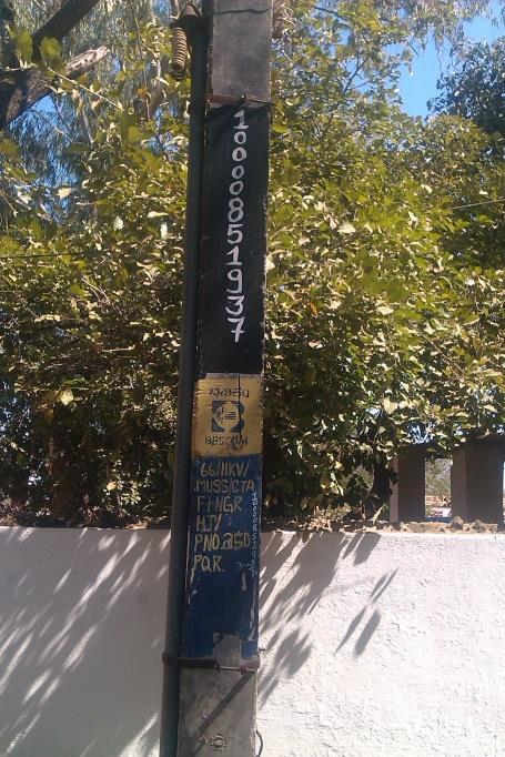
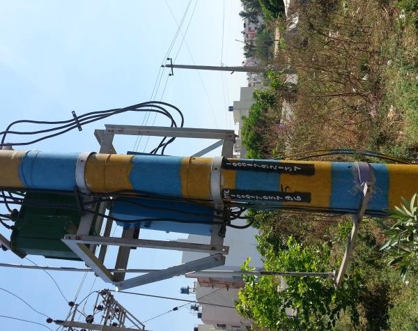
8 Challenges Field Survey challenges Lack of skilled manpower resources/ surveyors & Poor knowledge of Electric network Concurrent implementation of GIS across all DISCOMs in India Large no. of attributes specified for Assets & Consumers DGPS time-consuming Validation of data by utility field staff Non-availability of high quality standard GIS map data Asset painting Meeting the completion timeline owing to all the above Other challenges Bridging the gap created in assets & consumers data between Survey <> Go-Live Performance of Online application Training/ Re-training to all utility field officers on using online GIS application Updating live data in application by field officers through business process Slide No 8
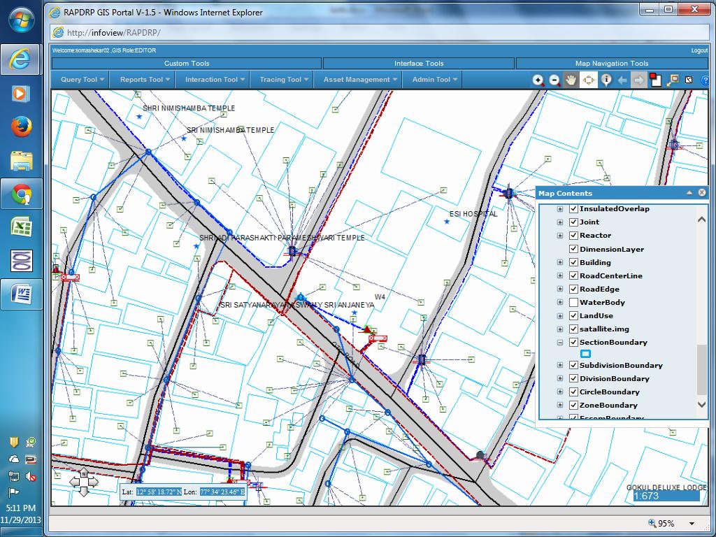
9 Solution Karnataka is one of the few states in India deploying online editing application Application is common for all 5 DISCOMs in Karnataka Online updating mechanism through integrated business processes New Connections not released unless updated in GIS Slide No 9


10 Solution Centralising online GIS updating activity: GIS cell of BESCOM is operational from June 2017 onwards and takes care of updating the assets & consumers in online GIS application GIS Cell activities: Updating live data of assets & consumers 766 New connection cases with network changes have been successfully updated in GIS system by GIS cell since June-2017 The other activities undertaken by GIS centralized team: Creation of Substations & Feeder taps Tagging of incremental consumers Re-indexing of consumers to correct assets in case of incorrect indexing Slide No 10
 Customer Revenue Management System (CRM) Network analysis and planning software")
 Outage Management System (OMS) of")
11 Status GIS is currently integrated with following: Work & Asset Management Systems (WAMS) Customer Revenue Management System (CRM) Network analysis and planning software (NA) Meter data management System (MDM) Energy Accounting System (EA) and also integrated with Distribution Automation System (DAS) Outage Management System (OMS) of DAS Slide No 11
12 Way forward GIS to be extended to semi-urban towns selected under IPDS project and subsequently to rest of rural sections of BESCOM Design of Mobile app using GIS data in association with K-GIS Corrective measures on Consumer indexing and asset mapping for accuracy of Energy Audit results and Network analysis. Derive complete benefits of GIS implementation Slide No 12

13 Lighting up your life Slide No 13
Presentation On GIS. Tarun Batra HoG-GIS Dhruba Banerjee - Team lead (Technical)
") Presentation On GIS Tarun Batra HoG-GIS Dhruba Banerjee - Team lead (Technical) Presentation Outline What is GIS? TPDDL s GIS Journey Component of GIS Project Phase of GIS GIS Applications GIS Landscape
Presentation On GIS Tarun Batra HoG-GIS Dhruba Banerjee - Team lead (Technical) Presentation Outline What is GIS? TPDDL s GIS Journey Component of GIS Project Phase of GIS GIS Applications GIS Landscape
Applications of GIS in Electrical Power System
 Applications of GIS in Electrical Power System Abdulrahman M. AL-Sakkaf 201102310 CRP 514 May 2013 Dr. Baqer M. AL-Ramadan Abstract GIS has been widely used in various areas and disciplines. This paper
ArcGIS. for Server. Understanding our World
 ArcGIS for Server Understanding our World ArcGIS for Server Create, Distribute, and Manage GIS Services You can use ArcGIS for Server to create services from your mapping and geographic information system
Enterprise GIS to Support ADMS ESRI GeoConx EGUG 2016 Parag Parikh
 October 20, 2016 ESRI GeoConX Enterprise GIS to Support ADMS ESRI GeoConx EGUG 2016 Parag Parikh Parag.Parikh@us.abb.com Slide 1 WE Energies Overview Total accounts: 2,240,640 Electric accounts: 1,148,805
About the Author: Abstract:
 Geospatial Technology: A Tool to estimate revenue loss from JJ Clusters in Delhi and implementation of Delhi Govt. Social Welfare Schemes Authors Name: Anil Kumar Rai+, Pooja Yadav+ & Varun Prakash* +Amity
Is Your GIS Ready For Grid Modernization? A State-of-the Industry Report
 Is Your GIS Ready For Grid Modernization? A State-of-the Industry Report Is Your GIS Ready For Grid Modernization? Survey Overview In the first quarter of 2019, Energy Acuity conducted a grid modernization
ArcGIS for Desktop. ArcGIS for Desktop is the primary authoring tool for the ArcGIS platform.
 ArcGIS for Desktop ArcGIS for Desktop ArcGIS for Desktop is the primary authoring tool for the ArcGIS platform. Beyond showing your data as points on a map, ArcGIS for Desktop gives you the power to manage
CHAPTER 22 GEOGRAPHIC INFORMATION SYSTEMS
 CHAPTER 22 GEOGRAPHIC INFORMATION SYSTEMS PURPOSE: This chapter establishes the administration and use of to improve the quality and accessibility of Department s spatial information and support graphical
Implementation Status & Results Congo, Republic of Rep. of Congo - Water, Electricity & Urban Development SIL (LEN) (P106975)
 (P106975)") Public Disclosure Authorized Public Disclosure Authorized The World Bank Implementation Status & Results Congo, Republic of Rep. of Congo - Water, Electricity & Urban Development SIL (LEN) (P106975) Operation
Public Disclosure Authorized Public Disclosure Authorized The World Bank Implementation Status & Results Congo, Republic of Rep. of Congo - Water, Electricity & Urban Development SIL (LEN) (P106975) Operation
The Geospatial Census: plans and progress for the 2010 round of population censuses
 The Geospatial Census: plans and progress for the 2010 round of population censuses David Rain, Assistant Professor of Geography & International Affairs, and Consultant to the United Nations/UNSD drain@gwu.edu
Oakland County Parks and Recreation GIS Implementation Plan
 Oakland County Parks and Recreation GIS Implementation Plan TABLE OF CONTENTS 1.0 Introduction... 3 1.1 What is GIS? 1.2 Purpose 1.3 Background 2.0 Software... 4 2.1 ArcGIS Desktop 2.2 ArcGIS Explorer
Public Disclosure Copy. Implementation Status & Results Report Strengthening Institutional Capacity for Government Effectiveness Project (P149176)
") Public Disclosure Authorized AFRICA Burundi Governance Global Practice IBRD/IDA Investment Project Financing FY 2015 Seq No: 4 ARCHIVED on 10-Jul-2017 ISR28718 Implementing Agencies: Government of Burundi,
Public Disclosure Authorized AFRICA Burundi Governance Global Practice IBRD/IDA Investment Project Financing FY 2015 Seq No: 4 ARCHIVED on 10-Jul-2017 ISR28718 Implementing Agencies: Government of Burundi,
JOB DESCRI PTI ON. GIS Administrator
 JOB DESCRI PTI ON JOB GRADE: GS-0 Cla ss Code : Office - 8 8 0 DEPARTMENT: 2 0 - FLSA: EXEMPT JOB NO: 6-0 9-2 7 SALARY: To Be De t e rm in e d Job description statements are intended to describe the general
Enabling Success in Enterprise Asset Management: Case Study for Developing and Integrating GIS with CMMS for a Large WWTP
 Enabling Success in Enterprise Asset Management: Case Study for Developing and Integrating GIS with CMMS for a Large WWTP Allison Blake, P.E. 1*, Matthew Jalbert, P.E. 2, Julia J. Hunt, P.E. 2, Mazen Kawasmi,
Ministry of Health and Long-Term Care Geographic Information System (GIS) Strategy An Overview of the Strategy Implementation Plan November 2009
 Strategy An Overview of the Strategy Implementation Plan November 2009") Ministry of Health and Long-Term Care Geographic Information System (GIS) Strategy An Overview of the Strategy Implementation Plan November 2009 John Hill, Health Analytics Branch Health System Information
Ministry of Health and Long-Term Care Geographic Information System (GIS) Strategy An Overview of the Strategy Implementation Plan November 2009 John Hill, Health Analytics Branch Health System Information
The World Bank Tamil Nadu Sustainable Urban Development Program (P150395)
") Public Disclosure Authorized Public Disclosure Authorized Public Disclosure Authorized Public Disclosure Authorized SOUTH ASIA India Social, Urban, Rural and Resilience Global Practice Global Practice
Public Disclosure Authorized Public Disclosure Authorized Public Disclosure Authorized Public Disclosure Authorized SOUTH ASIA India Social, Urban, Rural and Resilience Global Practice Global Practice
Better Topographic Map Production Using ArcGIS. A Comprehensive Solution for Mapping Organizations
 Better Topographic Map Production Using ArcGIS A Comprehensive Solution for Mapping Organizations The World Is Always Changing As a member of a national mapping organization, you know this is true. You
Understanding the Impact and Value of Esri s Utility Network for Network Management
 Understanding the Impact and Value of Esri s Utility Network for Network Management Mike Chiasson, Pasadena Water and Power (PWP) Anil Jayavarapu, Avineon, Inc. Esri GeoConX 2017 Presentation Outline Pasadena
MODERNIZATION OF THE MUNICIPAL MAPPING USING HIGH END GNSS SYSTEM AND GIS SOFTWARE
 MODERNIZATION OF THE MUNICIPAL MAPPING USING HIGH END GNSS SYSTEM AND GIS SOFTWARE Mr. R. A. R. Khan Assistant Engineer, Sewerage Utility Management Centre (SUMC) Municipal Corporation Of Greater Mumbai
Asset Management Planning. GIS and Asset Management Integration Readiness Assessment
 Asset Management Planning GIS and Asset Management Integration Readiness Assessment With too little data, you won t be able to make any conclusions that you trust. With loads of data you will find relationships
Road Ahead: Linear Referencing and UPDM
 Road Ahead: Linear Referencing and UPDM Esri European Petroleum GIS Conference November 7, 2014 Congress Centre, London Your Work Making a Difference ArcGIS Is Evolving Your GIS Is Becoming Part of an
The purpose of this report is to recommend a Geographic Information System (GIS) Strategy for the Town of Richmond Hill.
 Strategy for the Town of Richmond Hill.") Staff Report for Committee of the Whole Meeting Department: Division: Subject: Office of the Chief Administrative Officer Strategic Initiatives SRCAO.18.12 GIS Strategy Purpose: The purpose of this report
Staff Report for Committee of the Whole Meeting Department: Division: Subject: Office of the Chief Administrative Officer Strategic Initiatives SRCAO.18.12 GIS Strategy Purpose: The purpose of this report
GIS Capability Maturity Assessment: How is Your Organization Doing?
 GIS Capability Maturity Assessment: How is Your Organization Doing? Presented by: Bill Johnstone Principal Consultant Spatial Vision Group November 8, 2018 1. Motivation for Capability Maturity Models
Desktop GIS for Geotechnical Engineering
 Desktop GIS for Geotechnical Engineering Satya Priya Deputy General Manager (Software) RMSI, A-7, Sector 16 NOIDA 201 301, UP, INDIA Tel: +91-120-2511102 Fax: +91-120-2510963 Email: Satya.Priya@rmsi.com
The World Bank JM Youth Employment in Digital and Animation Industries (P148013)
") Public Disclosure Authorized LATIN AMERICA AND CARIBBEAN Jamaica Social, Urban, Rural and Resilience Global Practice Global Practice IBRD/IDA Investment Project Financing FY 2015 Seq No: 6 ARCHIVED on
Public Disclosure Authorized LATIN AMERICA AND CARIBBEAN Jamaica Social, Urban, Rural and Resilience Global Practice Global Practice IBRD/IDA Investment Project Financing FY 2015 Seq No: 6 ARCHIVED on
Applications of GIS in Electrical Power System. Dr. Baqer AL-Ramadan Abdulrahman Al-Sakkaf
 Applications of GIS in Electrical Power System Dr. Baqer AL-Ramadan Abdulrahman Al-Sakkaf OUTLINES: Objective Importance of GIS GIS data development Application of GIS Findings Conclusions and Recommendations
Bridging the Gap between Engineering and GIS
 Bridging the Gap between Engineering and GIS Presented by: Karen Stewart, B.Tech, GISP Manager of Geomatics Township of Langley February 13, 2006 Agenda Introduction History Goals Implementation Benefits
GIS Solution For Electric Utilities With Integration With Distribution Management System
 GIS Solution For Electric Utilities With Integration With Distribution Management System Agenda Importance Of The GIS GIS - DMS Integration Requirements Distribution Management System The Benefits Of The
The World Bank Tamil Nadu Sustainable Urban Development Program (P150395)
") Public Disclosure Authorized SOUTH ASIA India Social, Urban, Rural and Resilience Global Practice Global Practice IBRD/IDA Investment Project Financing FY 2015 Seq No: 6 ARCHIVED on 02-Dec-2017 ISR29908
Public Disclosure Authorized SOUTH ASIA India Social, Urban, Rural and Resilience Global Practice Global Practice IBRD/IDA Investment Project Financing FY 2015 Seq No: 6 ARCHIVED on 02-Dec-2017 ISR29908
Developing a Community Geographical Information System (GIS) in Rural India
 in Rural India") Developing a Community Geographical Information System (GIS) in Rural India Before rushing off and describing the unique challenges of developing a small scale GIS system India I better first describe
Developing a Community Geographical Information System (GIS) in Rural India Before rushing off and describing the unique challenges of developing a small scale GIS system India I better first describe
Winter Ready DC District of Columbia Public Service Commission
 Winter Ready DC District of Columbia Public Service Commission Presented by: Michael Poncia, Vice President, Customer Operations, Pepco Holdings October 26, 2017 Preparing our System Improving our system
GIS TECHNICIAN I GIS TECHNICIAN II
 GIS TECHNICIAN I GIS TECHNICIAN II CITY OF ROSEVILLE DEFINITION To perform a variety of technical office and field work duties related to the creation and maintenance of maps, tables, graphs and other
Corporate. Information. Railway Infrastructure Administrator. Year indracompany.com
 geospatial and mobility Corporate Geographic Information System of ADIF Railway Infrastructure Administrator. Year 2009-2010 Corporate Geographic Information System of ADIF ADIF. Spanish Administrator
September 2016 New ArcGIS Solutions
 September 2016 New ArcGIS Solutions Hydroelectric https://profservices.maps.arcgis.com/apps/mapjournal/index.html?appid=0ef98f74f8fb4f9da88 1adc521e1c90f Adopta Engage the public in the maintenance and
Seq No: 8 ARCHIVED on 21-May-2018 ISR30720 Created by: Raghava Neti on 04-Dec-2017 Modified by: Raghava Neti on 08-May-2018
 Public Disclosure Authorized SOUTH ASIA India Water Global Practice Requesting Unit: SACIN Responsible Unit: GWA06 IBRD/IDA Program-for-Results FY 2014 Team Leader(s): Raghava Neti Seq No: 8 ARCHIVED on
Web GIS: Architectural Patterns and Practices. Shannon Kalisky Philip Heede
 Web GIS: Architectural Patterns and Practices Shannon Kalisky Philip Heede Web GIS Transformation of the ArcGIS Platform Desktop Apps Server GIS Web Maps Web Scenes Layers Web GIS Transformation of the
ASSESSMENT. Industry Solutions Harness the Power of GIS for Property Assessment
 ASSESSMENT Industry Solutions Harness the Power of GIS for Property Assessment Esri Canada has thousands of customers worldwide who are using the transforming power of GIS technology to collect, maintain,
Module - 3 GIS MAPPING, MIS AND GIS UNDER RAY
 Module - 3 1 GIS MAPPING, MIS AND GIS MIS INTEGRATION UNDER RAY Role of GIS & MIS under RAY Under the scheme, two step implementation strategy has been adopted i.e. preparation of SFCPoAs on whole city
Application of GIS Technologies in maintenance and development of a Gas Transmission System
 Application of GIS Technologies in maintenance and development of a Gas Transmission System by Iva Juretić and Vanja Skopljak Štulić The main role of GIS, in addition to providing spatial data, is to create
Voices from Private Sector: Insights for Future NSDI Development in Indonesia
 Voices from Private Sector: Insights for Future NSDI Development in Indonesia Ta n d a n g Yu l i a d i D w i P u t ra, Ryosuke S h i b a s a k i I n st i t u t e o f I n d u st r i a l S c i e n c e,
OC Enterprise GIS. Kevin Hills, PLS Cameron Smith, GISP. OC Survey
 OC Enterprise GIS Kevin Hills, PLS Cameron Smith, GISP OC Survey Discussion Points Background & Organizational Structure of OCPW Past practices prior to Enterprise Wide GIS License (ELA) Participating
Implementation Status & Results Chad Urban Development Project (P072030)
") Public Disclosure Authorized Public Disclosure Authorized The World Bank Implementation Status & Results Chad Urban Development Project (P072030) Operation Name: Urban Development Project (P072030) Project
Public Disclosure Authorized Public Disclosure Authorized The World Bank Implementation Status & Results Chad Urban Development Project (P072030) Operation Name: Urban Development Project (P072030) Project
The World Bank Health System Performance Reinforcement Project (P156679)
") Public Disclosure Authorized AFRICA Cameroon Health, Nutrition & Population Global Practice IBRD/IDA Investment Project Financing FY 2016 Seq No: 3 ARCHIVED on 14-Apr-2017 ISR27518 Implementing Agencies:
Public Disclosure Authorized AFRICA Cameroon Health, Nutrition & Population Global Practice IBRD/IDA Investment Project Financing FY 2016 Seq No: 3 ARCHIVED on 14-Apr-2017 ISR27518 Implementing Agencies:
SOLUTIONS ADVANCED GIS. TekMindz are developing innovative solutions that integrate geographic information with niche business applications.
 ADVANCED GIS SOLUTIONS TekMindz are developing innovative solutions that integrate geographic information with niche business applications. TEK INDZ TM GIS Services Overview At the leading edge of geospatial
Introducing Spatial IQ
 Introducing Spatial IQ TM A Managed Services Approach to Enterprise GIS Let AppGeo be your bridge to the future. The Magic of Location AppGeo believes that information plus geography changes how we work
TOWARDS STRATEGIC SPATIAL PLANNING IN JAMAICA: THE NATIONAL SPATIAL PLAN
 TOWARDS STRATEGIC SPATIAL PLANNING IN JAMAICA: THE NATIONAL SPATIAL PLAN JIEP 5th Biennial Conference on the Environment: Balancing National Development and Environmental Protection June 6, 2011 Jamaica
Enabling ENVI. ArcGIS for Server
 Enabling ENVI throughh ArcGIS for Server 1 Imagery: A Unique and Valuable Source of Data Imagery is not just a base map, but a layer of rich information that can address problems faced by GIS users. >
SUMMARY REPORT FOR COUNCIL OF MINISTERS ON IMPORTANT DEVELOPMENTS IN POWER SECTOR DURING THE MONTH OF OCTOBER, 2018
 SUMMARY REPORT FOR COUNCIL OF MINISTERS ON IMPORTANT DEVELOPMENTS IN POWER SECTOR DURING THE MONTH OF OCTOBER, 2018 1. CAPACITY ADDITION (Generation and Transmission) (i) Thermal capacity 600 MW has been
The Social Life of Location. David Sonnen September 2008
 The Social Life of Location David Sonnen September 2008 Three Transformations Traditional Cartography -- 2300 B.C. - ~ 1980 Maps represent location and attributes Portable, persistent communication/ reference
DP Project Development Pvt. Ltd.
 Dear Sir/Madam, Greetings!!! Thanks for contacting DP Project Development for your training requirement. DP Project Development is leading professional training provider in GIS technologies and GIS application
Geography for the 2020 Round of Census
 Boundaries Key Census Data EA Id Population Male Female EA Id Area EA Id Num HH Avg HH size Geography for the 2020 Round of Census Linda Peters, Esri lpeters@esri.com Integration of Statistical and Geospatial
Evaluating e-government : implementing GIS services in Municipality
 Evaluating e-government : implementing GIS services in Municipality Municipality of Thessaloniki - G.I.S. Unit Misirloglou Symeon Head of the GIS Unit ESRI UC - 2016 The GIS Section - subset of the department
National GIS Platform for Digital India. Dr.(Mrs.) Vandana Sharma Deputy Director General National Informatics Centre
 Vandana Sharma Deputy Director General National Informatics Centre") National GIS Platform for Digital India Dr.(Mrs.) Vandana Sharma Deputy Director General National Informatics Centre sharma.vandana@nic.in NIC DEITY - National e-governance Infrastructure Meghraj Cloud
National GIS Platform for Digital India Dr.(Mrs.) Vandana Sharma Deputy Director General National Informatics Centre sharma.vandana@nic.in NIC DEITY - National e-governance Infrastructure Meghraj Cloud
Health GIS Tools and Applications Informing Decisions in Yemen
 Health GIS Tools and Applications Informing Decisions in Yemen Prepared by: Carleen Ghio 1, Mark Landry 1, Abdulkadir Nueman 2, and Ahmed Attieg 3 Presented at: Map Middle East Conference April 23-25,
GIS-T 2010 Building a Successful Geospatial Data Sharing Framework: A Ohio DOT Success Story
 GIS-T 2010 Building a Successful Geospatial Data Sharing Framework: A Ohio DOT Success Story ODOT District 2 GIS John Puente District 1 GIS Coordinator\ Planning Administrator 2 Interoperability 3 District
Leveraging Web GIS: An Introduction to the ArcGIS portal
 Leveraging Web GIS: An Introduction to the ArcGIS portal Derek Law Product Management DLaw@esri.com Agenda Web GIS pattern Product overview Installation and deployment Configuration options Security options
Exploit your geodata to enable smart cities and countries
 Exploit your geodata to enable smart cities and countries Carsten Rönsdorf, Head of Advisory Services Middle East Practice Manager Future Cities, standards and 3D 24 November 2014 Importance of Standards
Understanding Your Community A Guide to Data
 Understanding Your Community A Guide to Data Alex Lea September 2013 Research and Insight Team LeicestershireCounty Council Understanding Geographies Important to understand the various geographies that
The National Spatial Data Infrastructure of Zambia Shlomi SIVAN, Israel. Key words: National Land Audit, GIS, LIS, Common Spatial Data
 The National Spatial Data Infrastructure of Zambia Shlomi SIVAN, Israel Key words: National Land Audit, GIS, LIS, Common Spatial Data SUMMARY One of Zambia's important challenges is to recognize the title
Presented at the FIG Congress 2018, May 6-11, 2018 in Istanbul, Turkey
 Presented at the FIG Congress 2018, May 6-11, 2018 in Istanbul, Turkey INVESTIGATION OF THE SPATIAL ADDRESS RECORDING SYSTEM (SARS) PROJECT PROCESS TO BE BASE THE URBAN INFORMATION SYSTEM 1 FANİSE USLU,
How to Increase the Significance of your GIS
 How to Increase the Significance of your GIS Wade Kloos, GIS Director, Utah Department of Natural Resources wkloos@utah.gov 2014 Esri International User Conference July 17 How to Increase the Significance
Mapping Water Resources and Reservoirs for Climate Resilience in Zambezi River Basin
 Mapping Water Resources and Reservoirs for Climate Resilience in Zambezi River Basin Corné van der Sande, NEO BV Senior Advisor Earth Observation Services for Monitoring Drought and Water Resources in
OFWIM 2017 Annual Conference What Does Web GIS Really Mean for Fish and Wildlife Agencies?
 Content Open Mapping OFWIM 2017 Annual Conference What Does Web GIS Really Mean for Fish and Wildlife Agencies? Imagery Spatial Analysis Mike Bialousz, Esri 3D Data Exploration Real-Time Apps Visualization
Georeferencing and Satellite Image Support: Lessons learned, Challenges and Opportunities
 Georeferencing and Satellite Image Support: Lessons learned, Challenges and Opportunities Shirish Ravan shirish.ravan@unoosa.org UN-SPIDER United Nations Office for Outer Space Affairs (UNOOSA) UN-SPIDER
What s New in Collector for ArcGIS (Aurora)
") What s New in Collector for ArcGIS (Aurora) Derek Law (dlaw@esri.com) Esri Apps Product Management @GIS_Bandit Oct 10 th, 2018 Agenda Product overview Use cases Preparing data for Collector for ArcGIS
What s New in Collector for ArcGIS (Aurora) Derek Law (dlaw@esri.com) Esri Apps Product Management @GIS_Bandit Oct 10 th, 2018 Agenda Product overview Use cases Preparing data for Collector for ArcGIS
The GIS Path Forward Saskatchewan s Geomatics Strategic Plan
 The GIS Path Forward Saskatchewan s Geomatics Strategic Plan John Potter, SK Ministry of Central Services Office of Geomatics Coordination Sept.17/13 Table of Contents 1. 2011-2016, Geomatics Strategic
The Underutilization of GIS & How to Cure It. Adam Carnow Esri
 The Underutilization of GIS & How to Cure It Adam Carnow Esri What is GIS? A framework to organize, communicate, and understand the science of our world Business Intelligence (BI) is the set of
The World Bank Competitiveness and Enterprise Development Project (CEDP) (P130471)
 (P130471)") Public Disclosure Authorized AFRICA Uganda Trade & Competitiveness Global Practice IBRD/IDA Specific Investment Loan FY 2013 Seq No: 7 ARCHIVED on 30-Jun-2016 ISR23888 Implementing Agencies: Privatye Sector
Public Disclosure Authorized AFRICA Uganda Trade & Competitiveness Global Practice IBRD/IDA Specific Investment Loan FY 2013 Seq No: 7 ARCHIVED on 30-Jun-2016 ISR23888 Implementing Agencies: Privatye Sector
An Introduction to China and US Map Library. Shuming Bao Spatial Data Center & China Data Center University of Michigan
 An Introduction to China and US Map Library Shuming Bao Spatial Data Center & China Data Center University of Michigan Current Spatial Data Services http://chinadataonline.org China Geo-Explorer http://chinageoexplorer.org
Empowering water/wastewater network management with GIS
 Empowering water/wastewater network management with GIS Ioannis Kavouras_GIS Manager Surveying Engineer, MSc, MBA The Company responsible for fresh water distribution & sanitation serving 1.500.000 citizens
GIS ADMINISTRATOR / WEB DEVELOPER EVANSVILLE-VANDERBURGH COUNTY AREA PLAN COMMISSION
 GIS ADMINISTRATOR / WEB DEVELOPER EVANSVILLE-VANDERBURGH COUNTY AREA PLAN COMMISSION SALARY RANGE INITIATION $43,277 SIX MONTHS $45,367 POSITION GRADE PAT VI The Evansville-Vanderburgh County Area Plan
Geospatial Data Solutions: Site and Corridor Siting Projects. Rachel Turney-Work
 Geospatial Data Solutions: Site and Corridor Siting Projects Rachel Turney-Work Agenda GIS-based Corridor Routing Definition Major Components Uses and Functionality Geospatial Data Sources Data Accuracy
Geo-Spatial Technologies Application To Customs
 Geo-Spatial Technologies Application To Customs Hammamet September 26 th, 2017 GE-Data: previous experience Agenda Leveraging data through geography Geomatics GIS databases Information products and tools
GIS and the Other Enterprise Database
 GIS-T T Symposium GIS and the Other Enterprise Database March 31, 2004 Rapid City, South Dakota 1 Introduction Personal thoughts on recent evolution of GIS Shift in perspective from GIScentric to asset-centric
Web GIS & ArcGIS Pro. Zena Pelletier Nick Popovich
 Web GIS & ArcGIS Pro Zena Pelletier Nick Popovich Web GIS Transformation of the ArcGIS Platform Desktop Apps GIS Web Maps Web Scenes Layers Evolution of the modern GIS Desktop GIS (standalone GIS) GIS
CHAPTER 3 RESEARCH METHODOLOGY
 CHAPTER 3 RESEARCH METHODOLOGY 3.1 INTRODUCTION The research methodology plays an important role in implementing the research and validating the results. Therefore, this research methodology is derived
Towards National Geographic Information System in Nepal
 2 nd High Level Forum on Global Geospatial Information Management, Qatar National Convention Centre, Doha, Qatar, 4 6 February, 2013 Towards National Geographic Information System in Nepal Krishna Raj
Enhance Security, Safety and Efficiency With Geospatial Visualization
 Areas within 10 minutes of an exit are emphasized on this map, to give an indication of how accessible neighborhoods are by highway. The colors represent 1, 3, 5 and 10 minute increments from the exits.
GIS Mapping of Gas Pipeline Distribution Network
 GIS Mapping of Gas Pipeline Distribution Network Furqan Iqbal PhD Student at Punjab University, Pakistan Phone: 0470432323, +923344055563 Email: furqangis@gmail.com Furqan Iqbal Furqan Iqbal earned his
The World Bank Indonesia National Slum Upgrading Project (P154782)
") Public Disclosure Authorized EAST ASIA AND PACIFIC Indonesia Social, Urban, Rural and Resilience Global Practice Global Practice IBRD/IDA Investment Project Financing FY 2017 Seq No: 2 ARCHIVED on 19-May-2017
Public Disclosure Authorized EAST ASIA AND PACIFIC Indonesia Social, Urban, Rural and Resilience Global Practice Global Practice IBRD/IDA Investment Project Financing FY 2017 Seq No: 2 ARCHIVED on 19-May-2017
Enhancements and Validation of a Demand Forecast Tool for South Australian Water Corporation
 ISSN 2206-1991 Volume 3 No 4 2018 https://doi.org/10.21139/wej.2018.041 Enhancements and Validation of a Demand Forecast Tool for South Australian Water Corporation Managing complexities in operations
CREATING LIVEABLE & SAFE CITIES FOR ALL
 CREATING LIVEABLE & SAFE CITIES FOR ALL Taking Transit to people s door steps PRERNA V. MEHTA, MANAGER, WRI INDIA RAJEEV G. MALAGI, SR. PROJECT ASSOCIATE, WRI INDIA A product of WRI Ross Center for Sustainable
GIS and Governing Anchorage. GIS Critical for Efficient, Transparent Government How is GIS Program Doing Where can GIS Program Take us
 GIS and Governing Anchorage GIS Critical for Efficient, Transparent Government How is GIS Program Doing Where can GIS Program Take us Municipality of Anchorage Office of Economic And Community Development
No. of Days. Building 3D cities Using Esri City Engine ,859. Creating & Analyzing Surfaces Using ArcGIS Spatial Analyst 1 7 3,139
 Q3 What s New? Creating and Editing Data with ArcGIS Pro Editing and Maintaining Parcels Using ArcGIS Spatial Analysis Using ArcGIS Pro User Workflows for ArcGIS Online Organizations Q3-2018 ArcGIS Desktop
Flood Mapping Michael Durnin October 9 th
 Michael Durnin October 9 th 2014 Leading Surveyors Company Profile Est. 1983 Celebrating 30 Years in Business Six Offices in UK & Ireland Over 30 Specialised Survey Services ISO 9001:2008 Registered Over
Public Disclosure Copy
 Public Disclosure Authorized AFRICA Guinea Social, Urban, Rural and Resilience Global Practice Global Practice IBRD/IDA Investment Project Financing FY 2016 Seq No: 3 ARCHIVED on 01-Nov-2017 ISR30006 Implementing
Introduction to Portal for ArcGIS
 Introduction to Portal for ArcGIS Derek Law Product Management March 10 th, 2015 Esri Developer Summit 2015 Agenda Web GIS pattern Product overview Installation and deployment Security and groups Configuration
7 GEOMATICS BUSINESS SOLUTIONS - ANNUAL REPORT 2006
 7 GEOMATICS BUSINESS SOLUTIONS - ANNUAL REPORT 2006 The Planning and Economic Development Committee recommends the adoption of the recommendation contained in the following report November 30, 2006, from
GIS PORTFOLIO MOHAMED MAGDY MOHAMED HUSSAIN GIS ENGINEER. UWF GIS ONLINE CERTIFICATE GIS Internship (GIS4944)
") 2012 GIS PORTFOLIO MOHAMED MAGDY MOHAMED HUSSAIN GIS ENGINEER UWF GIS ONLINE CERTIFICATE GIS Internship (GIS4944) Portfolio Table of Contents Subject... Page Personal statement/mission/philosophy... 1
2012 GIS PORTFOLIO MOHAMED MAGDY MOHAMED HUSSAIN GIS ENGINEER UWF GIS ONLINE CERTIFICATE GIS Internship (GIS4944) Portfolio Table of Contents Subject... Page Personal statement/mission/philosophy... 1
INSPIRing Geospatial Framework For Local Administrations
 This project is financed by the European Union and the Republic of Turkey Presented at the FIG Congress 2018, May 6-11, 2018 in Istanbul, Turkey National Programme for Turkey 2010 Instrument for Pre-Accession
ArcGIS Online Routing and Network Analysis. Deelesh Mandloi Matt Crowder
 ArcGIS Online Routing and Network Analysis Deelesh Mandloi Matt Crowder Introductions Who are we? - Members of the Network Analyst development team Who are you? - Network Analyst users? - ArcGIS Online
Web GIS Administration: Tips and Tricks
 EdUC 2017 July 8 th, 2017 Web GIS Administration: Tips and Tricks Geri Miller Agenda Concerns Acknowledged User Management Content Management Monitoring Licensing and logins Sophistication of IT support
GIS for the Beginner on a Budget
 GIS for the Beginner on a Budget Andre C. Bally, RLA, GIS Coordinator, Harris County Public Infrastructure Department Engineering Division This presentation, GIS for Beginners on a Budget. will briefly
The World Bank India: Bihar Integrated Social Protection Strengthening Project (P118826)
") Public Disclosure Authorized SOUTH ASIA India Social Protection & Labor Global Practice IBRD/IDA Investment Project Financing FY 2014 Seq No: 5 ARCHIVED on 13-May-2016 ISR23158 Implementing Agencies: Rural
Public Disclosure Authorized SOUTH ASIA India Social Protection & Labor Global Practice IBRD/IDA Investment Project Financing FY 2014 Seq No: 5 ARCHIVED on 13-May-2016 ISR23158 Implementing Agencies: Rural
The Emerging Role of Enterprise GIS in State Forest Agencies
 The Emerging Role of Enterprise GIS in State Forest Agencies Geographic Information System (GIS) A geographic information system (GIS) is a computer software system designed to capture, store, manipulate,
Oregon Department of Transportation. Geographic Information Systems Strategic Plan
 Oregon Department of Transportation Geographic Information Systems Strategic Plan Adopted May, 2000 By the GIS Steering Committee Last printed 10/2/2012 4:20:00 PM Page Geographic Information Systems Strategic
How GIS can be used for improvement of literacy and CE programmes
 How GIS can be used for improvement of literacy and CE programmes Training Workshop for Myanmar Literacy Resource Center (MLRC) ( Yangon, Myanmar, 11 20 October 2000 ) Presented by U THEIN HTUT GEOCOMP
Mapping and GIS TIME Tra T ining ining - SE S P E, P NEUH AUS US N, GERM ANY
 Mapping and GIS Maps and Humanitarian assistance Geographic coordinate system A geographic coordinate system is a coordinate system that enables every location on the Earth to be specified by a set of
How a Media Organization Tackles the. Challenge Opportunity. Digital Gazetteer Workshop December 8, 2006
 A Case-Study-In-Process: How a Media Organization Tackles the Georeferencing Challenge Opportunity Digital Gazetteer Workshop December 8, 2006 to increase and diffuse geographic knowledge 1888 to 2006:
The World Bank IN Maharashtra Rural Water Supply and Sanitation Program (P126325)
") Public Disclosure Authorized SOUTH ASIA India Water Global Practice IBRD/IDA Program-for-Results FY 2014 Seq No: 5 ARCHIVED on 23-Jun-2016 ISR24264 Implementing Agencies: Public Disclosure Authorized Program
Public Disclosure Authorized SOUTH ASIA India Water Global Practice IBRD/IDA Program-for-Results FY 2014 Seq No: 5 ARCHIVED on 23-Jun-2016 ISR24264 Implementing Agencies: Public Disclosure Authorized Program