MAPPING ALASKA S WATERS
|
|
|
- Neil Horn
- 5 years ago
- Views:
Transcription


1 MAPPING ALASKA S WATERS NHD Advisory Team Call December, K a c y K r i e ge r kacy.krieger@uaa.alaska.edu Alaska Hydrography Coordinator

2 ALASKA S WATER > 3,000,000 Mapped Lakes and Ponds > 847,000 Length of Mapped Streams and Rivers in miles 47,000 Length of Mapped Coastline in miles 1,980 Length of the longest river, the Yukon, in miles 616 Named Glaciers 40% Share of the Nation s Surface Water 2


3 HYDROGRAPHY CHALLENGES IN ALASKA Rapidly Changing Coastline Complex Channels Extreme Tidal Ranges Remote Locations Expansive Wetlands Disconnected Networks 3
4 History of Hydrography in Alaska NHD in Alaska began approximately 15 years ago Primarily using 50 year old data from original USGS Topos NHD at 1:63,360 scaled Multiple partners provided data to USGS Divergence of the datasets since NHD adoption in Alaska since then has been modest Agencies maintained their own hydrography data until recently Authoritative NHD dataset remained mostly unchanged. 4
5 State of Hydrography in Alaska AK Hydro Southcentral Database Streams National Hydrography Dataset Flowlines Alaska Department of Fish & Game Anadromous Water Catalog Streams Kenai Peninsula Borough Surface Hydrology 5


6 Kenai Peninsula Borough Surface Hydrology 6
7 National Hydrography Dataset Flowlines 7

8 Alaska DFG AWC Streams 8

9 KWF Improved Streamlines 9


10 FIXING HYDROGRAPHY 10
11 Alaska Hydrography Technical Working Group Created for hydrography data and editing standard operating procedure coordination and collaboration, including outreach and communication with to the broader mapping community. Created under Alaska Climate Change Executive Roundtable (ACCER) Charter signed by ACCER Co Chairs 6 Federal agencies (BLM, NPS, NOAA, USFS, USFWS, USGS) and 4 AK State entities (ADFG, ADEC, ADNR, UA), plus invited technical advisors 11


12 ALASKA HYDROGRAPHY TECHNICAL WORKING GROUP Agency Primary Member Primary Alaska Department of Environmental Conservation Cliff Jones Alaska Department of Fish and Game J Johnson j.johnson@alaska.gov Alaska Department of Natural Resources Wendy Steinberger wendy.steinberger@alaska.gov Bureau of Land Management Matt Varner mvarner@blm.gov National Oceanic and Atmospheric Administration Tim Smith timothy.m.smith@noaa.gov National Park Service Joni Piercy joni_piercy@nps.gov University of Alaska Kim Homan kim.homan@uas.alaska.edu U.S. Fish and Wildlife Service Bill Rice William_Rice@fws.gov U.S. Forest Service Erik Johnson ejohnson02@fs.fed.us U.S. Geological Survey Becci Anderson rdanderson@usgs.gov 12
13 AHTWG Coordination to Date AHTWG meeting monthly since May, 2013, now meeting quarterly Several Focus Groups meeting regularly NHDPlus Data Model Standards Data Editing Standards Communications Group has already resulted in enhanced coordination between agencies Data contributions: ADNR and TNC have uncaptured data updates Common editing standards: Creation, implementation, outreach and revision Enhanced coordination with USGS: Establish monthly USGS NHD/AK Hydro technical call Common way forward: Agreement to use AK Hydro to update the NHD in Alaska where available 13
14 National LCC Grant LCC/Fish Habitat Partnership/AHTWG/USGS NHD/ACSC Alaska hydrography mapping project funded for $300k Funds moved to University of Alaska for positions AK Hydro Program Coordinator Hired (UAA) AK Hydro Technical Steward funding continued (UAS) Funds moved for on-the-ground edits and hydro updates SMUMN - Arctic TEONs watersheds UAA Nushagak and Kvichak watersheds 14

15 AK HYDRO The Alaska Hydrography Database Regional collaborative databases housed and managed by the University of Alaska and funded by federal and state partners; which is used to store local attributes and generate updates for the NHD. Simplified workflow Basic editing requirements Elastic data model Shared update effort Centralized NHD stewardship Updating the NHD is the goal 15

16 Why AK Hydro Addresses a backlog of hydrography updates Used to store local attributes and generate updates for the NHD Ultimate goal to improve the NHD A Collaborative Database Addresses concerns with NHD in Alaska Funded by federal and state partners Located in an ArcSDE instance Housed and managed by the University of Alaska Award winning and sanctioned by the NHD 16

17 AK Hydro and the NHD Similar, but not the same Local requirements vs. national requirements Feature Classes vs. Feature Types Sharing consistent geometry Updates can go in either direction Updating the NHD is the goal 17

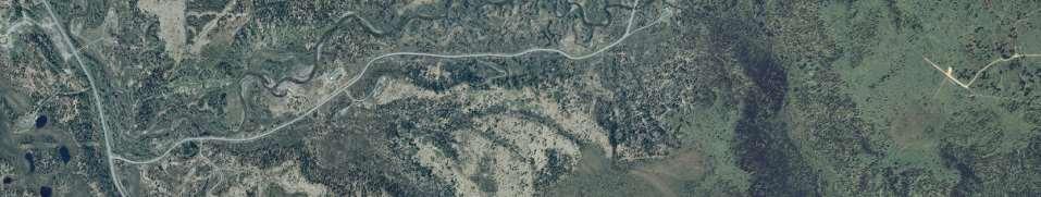
18 18
19 AK Hydro Workflow Goal: Update the NHD Database Replication to Partners Checkout local replica Local Desktop Edits Check-in local replica Database Synchronization to UA Transform and Conflate to NHD 19

20 Agency Requirements for AK Hydro Collaboration A Centralized Spatial Database Basic DBA Experience Agency Expertise Basic Desktop Editing Experience Compatible Software 20

21 Stewardship Responsibilities Partners Provide Agency Coordination Application of Standards Geometric Updates Editing QA Replica Admin and Mgmt. Replica Synchronization AHTWG participation AK Hydro Provides Stewardship Coordination Application of Standards Database QA NHD Updates Database Admin and Mgmt. Technical Support AHTWG participation 21

22 Update the NHD 22
23 Where do we begin? Digital Orthophotos Digital Planimetric Data Digital Elevation Data Digital SDMI Imagery Field Verified Reference Data Other Sources 23

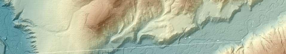
24 Legacy 60-m elevation data Cutler River, Noatak NP Missing terrain and hydrology features such as rivers and lakes in legacy NED data. Missing River

25 IfSAR 5-m Elevation Data Cutler River, Noatak NP Intermap DTM includes detailed hydrology and terrain features.

26 IfSAR Improves Alaska Hydrography Mapping

27 IfSAR Status 27

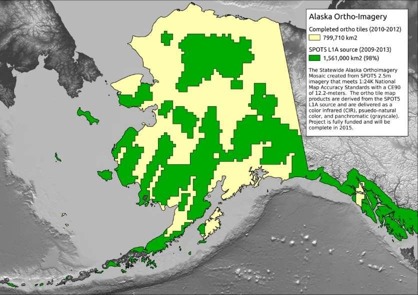
28 Statewide Ortho-imagery 28
29 Where are we today? ADEC: Impaired waters, NHDPlus ADFG: Anadromous Waters Catalog ADNR: Navigable waters ADOT: Pilot project in Port Clarence BLM: updating NHD in NPR-A EPA: NHDPlus Kenai Watershed Forum: Updated NHD streams on Kenai Peninsula, will begin updating lakes and 2D features NOAA: Coastlines, bathymetric surveys NPS: Completed Denali NPP, Cape Krusenstern and Bering Land Bridge NP. Will begin Glacier Bay NPP and other lands soon. The Nature Conservancy: SW Alaska and Mat-Su Basin USFWS: On and off refuge USFS: Tongass and Chugach NF USGS: Glaciers, US Topo areas, fix NHD data model errors prior to agency/ak Hydro editing, and research into elevation derived streams from LiDAR and new 5-meter IfSAR data 29

30 Current as of August 18, Does not include ongoing maintenance and support from USGS NHD program. 30

31 NATIONAL PARK SERVICE Denali National Park & Preserve Bering Land Bridge National Park Cape Krusenstern National Monument Glacier Bay National Park Coastline updated in other parks 5m IfSAR elevation data and SPOT 5 orthoimagergy 31

32 NUSHAGAK & KVICHAK BASINS Funded through WALCC and USGS 19,300 mi 2 5 ½ HUC 8 sub-basins 34,000 stream miles Updated streamlines from TNC QA/QC work to be performed by UAA undergraduate interns Review data and update to national standards as required. 32

33 ARCTIC TEON WATERSHEDS Kokolik River Watershed Agashashok River Watershed Kuparuk River Watershed Update and densify 1D and 2D features Update using 2.5 m SPOT 5 orthoimagery (RGB and CIR), and 5-meter IfSAR elevation data Multi-Agency (LCC) effort 33

34 KENAI PENINSULA Updates generated from LiDAR and aerial imagery Validation involved outreach activities 1D features updated 2D feature updates in progress AK Hydro SCAK database used to conflate to NHD First round of updates performed by Kenai Watershed Forum Multiple funding partners 34

35 TONGASS & CHUGACH NATIONAL FORESTS Alaska NHD update and AK Hydro pioneers Continue to edit in Tongass and Chugach National Forests Updates conflated to NHD through AK hydro 35

36 MATANUSKA SUSITNA BASIN One of the most ambitious projects to date Entire Mat-Su Basin 25,500 mi 2 6 HUC 8 sub-basins 1D and 2D features to be updated Elevation derived streams from IfSAR and LiDAR Extensive ground-truthing Collaborative project funded by many partners 36

37 PORT CLARENCE Pilot Project for IfSAR Hydro automation 3,030 mi 2 Elevation, imagery, hydrography, transportation integration 5m IfSAR elevation data and Rapideye orthoimagergy NHDPlus pilot project Funded through USGS and AK DOT 37

38 AK Hydro Resources Web Map Services ArcGIS Online Webmaps 38
E.W. Johnson 1 and M. Plivelich 2
 E.W. Johnson 1 and M. Plivelich 2 Summary A regionalized approach is being established for the collaborative stewardship of the National Hydrography Dataset (NHD) by state, federal, and university partners
Alaska Hydrography Strategic Plan
 Alaska Hydrography Strategic Plan Mapping Alaska s Water 2017-2021 Prepared by the Alaska Hydrography Technical Working Group and Alaska Hydrography Database Alaska Hydrography Strategic Plan A laska is
USGS Hydrography Overview. May 9, 2018
 + 1 USGS Hydrography Overview May 9, 2018 + 2 The National Geospatial Program Provides the geospatial baseline of the Nation s topography, natural landscape and built environment through The National Map,
U.S. Geological Survey Agency Briefing for MAPPS Mark L. DeMulder Director, National Geospatial Program. March 12, 2013
 + U.S. Geological Survey Agency Briefing for MAPPS Mark L. DeMulder Director, National Geospatial Program March 12, 2013 + 3D Elevation Program (3DEP) National Leadership The National Enhanced Elevation
The National Hydrography Dataset in the Pacific Region. U.S. Department of the Interior U.S. Geological Survey
 The National Hydrography Dataset in the Pacific Region U.S. Department of the Interior U.S. Geological Survey The National Map The National Map is built on partnerships and standards The National Map consists
Geospatial Data, Services, and Products. National Surveying, mapping and geospatial conference
 Geospatial Data, Services, and Products Federal Programs -- USDA NRCS National Surveying, mapping and geospatial conference March 15, 2016 NRCS Applications using Geosaptial Products & Services Field
3D Elevation Program- Status and Updates. Oklahoma GI Council Meeting November 2, 2018 Claire DeVaughan US Geological Survey
 + 1 3D Elevation Program- Status and Updates Oklahoma GI Council Meeting November 2, 2018 Claire DeVaughan US Geological Survey + 2 3D Elevation Program (3DEP) Goals Complete acquisition in 8 years Address
1) make sure folks know what s available in terms of geospatial data and resources that could contribute to their decision support toolkits;
 make sure folks know what s available in terms of geospatial data and resources that could contribute to their decision support toolkits;") Introduction 1 2001 It was born out of the recognition that several of the regions prominent resource management agencies have similar, if not shared, requirements for GIS data. Some of the underlying
Introduction 1 2001 It was born out of the recognition that several of the regions prominent resource management agencies have similar, if not shared, requirements for GIS data. Some of the underlying
Improvement of the National Hydrography Dataset for Parts of the Lower Colorado Region and Additional Areas of Importance to the DLCC
 Improvement of the National Hydrography Dataset for Parts of the Lower Colorado Region and Additional Areas of Importance to the DLCC Carlos Reyes-Andrade California State University, Northridge September
International Geospatial Harmonization of Sister Datasets Hydrography and Watershed Boundaries between Canada and the U.S.A
 International Geospatial Harmonization of Sister Datasets Hydrography and Watershed Boundaries between Canada and the U.S.A by Judy Kwan and Pete Steeves Environment Canada and US Geological Survey in
Esri Image & Mapping Forum 9 July 2017 Geiger-Mode for Conservation Planning & Design by USDA NRCS NGCE
 Esri Image & Mapping Forum 9 July 2017 Geiger-Mode for Conservation Planning & Design by USDA NRCS NGCE For over 75 years, the Natural Resources Conservation Service has been a pioneer in conservation,
National Hydrography Dataset (NHD) Update Project for US Forest Service Region 3
 Update Project for US Forest Service Region 3") National Hydrography Dataset (NHD) Update Project for US Forest Service Region 3 Allison Moncada California State University, Northridge February 2017 July 2017 Advisor: Joel Osuna Center for Geographical
National Hydrography Dataset (NHD) Update Project for US Forest Service Region 3 Allison Moncada California State University, Northridge February 2017 July 2017 Advisor: Joel Osuna Center for Geographical
Statewide Topographic Mapping Program
 Statewide Topographic Mapping Program February 28, 2018 www.dotd.la.gov Outline Purpose of the Statewide Topographic Mapping Program History Breakdown of R.S. 48:36 - Topographic Mapping Statewide Topographic
The 3D Elevation Program: Overview. Jason Stoker USGS National Geospatial Program ESRI 2015 UC
 + The 3D Elevation Program: Overview Jason Stoker USGS National Geospatial Program ESRI 2015 UC + 2 A little history USGS has a long, proud tradition of mapmaking (2009) + 3 The changing times Mapping
A Comprehensive Inventory of the Number of Modified Stream Channels in the State of Minnesota. Data, Information and Knowledge Management.
 A Comprehensive Inventory of the Number of Modified Stream Channels in the State of Minnesota Data, Information and Knowledge Management Glenn Skuta Environmental Analysis and Outcomes Division Minnesota
What's New with NHDPlus (Classic)?
?") What's New with NHDPlus (Classic)? 1987 Reach File Version 1 2017 - NHDPlus Annie Mejaes EPA, Office of Water 2 Overview NHD-NHDPlus Basics Evolving NHD-NHDPlus Data and Tools Training and Support The
What's New with NHDPlus (Classic)? 1987 Reach File Version 1 2017 - NHDPlus Annie Mejaes EPA, Office of Water 2 Overview NHD-NHDPlus Basics Evolving NHD-NHDPlus Data and Tools Training and Support The
Leveraging LiDAR for Statewide NHD Hydrography Projects. Susan Phelps, CFM, GISP
 Leveraging LiDAR for Statewide NHD Hydrography Projects Susan Phelps, CFM, GISP Mon, July 11 th, 2016 National Hydrography Dataset (NHD) Background Why Local-Res NHD? Drivers Include: Availability of accurate
Summary Description Municipality of Anchorage. Anchorage Coastal Resource Atlas Project
 Summary Description Municipality of Anchorage Anchorage Coastal Resource Atlas Project By: Thede Tobish, MOA Planner; and Charlie Barnwell, MOA GIS Manager Introduction Local governments often struggle
ELEVATION IS FOUNDATIONAL. A DEM that is inaccurate or of poor resolution will pass those characteristics onto other data layers
 ELEVATION IS FOUNDATIONAL A DEM that is inaccurate or of poor resolution will pass those characteristics onto other data layers THE DEM IS FOUNDATIONAL TO ALL GIS (Geospatial Information System) LAYERS
USGS National Geospatial Program Understanding User Needs. Dick Vraga National Map Liaison for Federal Agencies July 2015
 + USGS National Geospatial Program Understanding User Needs Dick Vraga National Map Liaison for Federal Agencies July 2015 + Topics 2 Background Communities of Use User Surveys National Map Liaisons Partnerships
Hydrography Webinar Series
 Hydrography Webinar Series Session 2 May 21, 2015 U.S. Department of the Interior U.S. Geological Survey U.S. GEOLOGICAL SURVEY HYDROGRAPHY WEBINAR SERIES Hosted by: Jeff Simley Al Rea Hydrography Webinar
Improvement of the National Hydrography Dataset for US Forest Service Region 3 in Cooperation with the National Forest Service
 Improvement of the National Hydrography Dataset for US Forest Service Region 3 in Cooperation with the National Forest Service Christian L. DeCasas California State University, Northridge November 7 th,
NATIONAL HYDROGRAPHY DATASET (NHD) UPDATE PROJECT FOR US FOREST SERVICE REGION 3
 UPDATE PROJECT FOR US FOREST SERVICE REGION 3") NATIONAL HYDROGRAPHY DATASET (NHD) UPDATE PROJECT FOR US FOREST SERVICE REGION 3 Allison Moncada California State University, Northridge February 2018 July 2018 Advisor: Joel Osuna Center for Geospatial
NATIONAL HYDROGRAPHY DATASET (NHD) UPDATE PROJECT FOR US FOREST SERVICE REGION 3 Allison Moncada California State University, Northridge February 2018 July 2018 Advisor: Joel Osuna Center for Geospatial
USGS National Hydrography Dataset (NHD) and NHDPlus
 and NHDPlus") + 1 + USGS National Hydrography Dataset (NHD) and NHDPlus Al Rea USGS National Geospatial Program Western States Water Council August 1, 2018 + 2 USGS National Hydrography Datasets Hydrologic networks,
+ 1 + USGS National Hydrography Dataset (NHD) and NHDPlus Al Rea USGS National Geospatial Program Western States Water Council August 1, 2018 + 2 USGS National Hydrography Datasets Hydrologic networks,
Philippines NSDI Foundation Data Program. Andrew Bashfield
 Philippines NSDI Foundation Data Program Andrew Bashfield 1 Overview Part 1: Building the NSDI Framework Part 2: Collecting Foundation Datasets 2 Building the NSDI Framework Background & NDSI Overview
Vegetation and Wildlife Habitat Mapping Study in the Upper and Middle Susitna Basin Study Plan Section 11.5
 (FERC No. 14241) Vegetation and Wildlife Habitat Mapping Study in the Upper and Middle Susitna Basin Study Plan Section 11.5 Initial Study Report Part C: Executive Summary and Section 7 Prepared for Prepared
USGS Community Engagement and its Role in Improving The National Map
 USGS Community Engagement and its Role in Improving The National Map ESRI User Conference, 2014 Bob Davis Carol Ostergren Drew Decker USGS Strategic Direction Provides a sharpened focus on our topographic
What s New in Topographic Information - USGS National Map
 + What s New in Topographic Information - USGS National Map SARGIS Workshop November 14, 2016 Rob Dollison, 703-648-5724 rdollison@usgs.gov + USGS 2 National Geospatial Program The National Geospatial
MAPPS/USGS Liaison Meeting U.S. Department of the Interior U.S. Geological Survey
 MAPPS/USGS Liaison Meeting U.S. Department of the Interior U.S. Geological Survey Kevin Gallagher, Associate Director, Core Science Systems Greg Stensaas, Earth Resources and Observation Science Center
StreamStats: Delivering Streamflow Information to the Public. By Kernell Ries
 StreamStats: Delivering Streamflow Information to the Public By Kernell Ries U.S. Department of the Interior U.S. Geological Survey MD-DE-DC District 410-238-4317 kries@usgs.gov StreamStats Web Application
Georeferencing Water Quality Assessments to NHDPlus Catchments
 Georeferencing Water Quality Assessments to NHDPlus Catchments A New Approach to Evaluating and Measuring Progress in Surface Water Quality DWANE YOUNG, U.S. EPA, OFFICE OF WATER Outline Georeferencing
3D Elevation Program, Lidar in Missouri. West Central Regional Advanced LiDAR Workshop Ray Fox
 3D Elevation Program, Lidar in Missouri West Central Regional Advanced LiDAR Workshop Ray Fox National Enhanced Elevation Assessment (Dewberry, 2011) Sponsored by the National Digital Elevation Program
NEEA Refresh aka 3D Nation Requirements and Benefits Study. Allyson Jason, Carol Ostergren, Xan Fredericks and Lou Driber November 9, 2017
 + NEEA Refresh aka 3D Nation Requirements and Benefits Study Allyson Jason, Carol Ostergren, Xan Fredericks and Lou Driber November 9, 2017 + 2 Study Context Background The National Enhanced Elevation
Base Maps: Creating, Using & Participating
 Base Maps: Creating, Using & Participating Michael Fashoway & Erin Geraghty Montana Base Map Service Center 2010 MAGIP Technical Session October 28, 2010 What is a Base Map? Using a Base Map Creating a
Designing a Dam for Blockhouse Ranch. Haley Born
 Designing a Dam for Blockhouse Ranch Haley Born CE 394K GIS in Water Resources Term Paper Fall 2011 Table of Contents Introduction... 1 Data Sources... 2 Precipitation Data... 2 Elevation Data... 3 Geographic
ArcGIS Online Tools and Water-Related Web Services You Can Use Every Day of Your Life!
 ArcGIS Online Tools and Water-Related Web Services You Can Use Every Day of Your Life! Brian Rowley, PE, CFM FMA 2014 Annual Conference 1 Gold Rush (49ers) John Sutter Sutter s Mill South fork of American
MISSOURI LiDAR Stakeholders Meeting
 MISSOURI LiDAR Stakeholders Meeting East-West Gateway June 18, 2010 Tim Haithcoat Missouri GIO Enhanced Elevation Data What s different about it? Business requirements are changing.fast New data collection
The Arctic Landscape Conservation Cooperative Conservation Goals
 The Arctic Landscape Conservation Cooperative Conservation Goals Adopted by the Arctic LCC Steering Committee, 24 August 2010 Background : Landscape Conservation Cooperatives and Climate Science Centers
The National Map State Business Plan
 The National Map State Business Plan D-R-A-F-T Prepared by the West Virginia GIS Technical Center (February 2004) Vision The National Map is envisioned by the USGS as a seamless, continuously maintained,
Office of Technology Partnerships GIS Collaboration
 Office of Technology Partnerships GIS Collaboration State GIS Update April 21, 2017 Mark Holmes, GISP Outline MGF Upgrade Project Census Programs Imagery Update LiDAR Update Open Discussion 2 MGF Background
GRAPEVINE LAKE MODELING & WATERSHED CHARACTERISTICS
 GRAPEVINE LAKE MODELING & WATERSHED CHARACTERISTICS Photo Credit: Lake Grapevine Boat Ramps Nash Mock GIS in Water Resources Fall 2016 Table of Contents Figures and Tables... 2 Introduction... 3 Objectives...
Hydrologically Consistent Pruning of the High- Resolution National Hydrography Dataset to 1:24,000-scale
 Hydrologically Consistent Pruning of the High- Resolution National Hydrography Dataset to 1:24,000-scale Lawrence V. Stanislawski 1, Ariel Doumbouya 2, Barbara P. Buttenfield 3, 1 Center for Excellence
Geospatial Data Sources. SLO GIS User Group June 8, 2010
 Geospatial Data Sources SLO GIS User Group June 8, 2010 Presenters Drew Decker USGS Southern California Geospatial Liaison Kelly Bobbitt Mike Bobbitt & Associates Joe Larson Cal Fire Peter Meertens Regional
Projects Funded in 2012
 Arctic Landscape Conservation Cooperative Advancing Science, Understanding Change. Projects Funded in 2012 The Big Picture In 2012, the Arctic LCC funded wholly, or in part, 16 projects and study planning
A Temporal Hydrologic Database for Rapidly Changing Landscapes
 A Temporal Hydrologic Database for Rapidly Changing Landscapes Using Mt. St. Helens in Washington as a Pilot Site Adam Mosbrucker Geog 575 BACKGROUND: Client / User U.S. Geological Survey Cascades Volcano
Lecture 3. Data Sources for GIS in Water Resources
 Lecture 3 Data Sources for GIS in Water Resources GIS in Water Resources Spring 2015 http://www.data.gov/ 1 USGS GIS data for Water http://water.usgs.gov/maps.html Watersheds of the US 2-digit water resource
Presented by: Ki r k Cont r ucci, CP Ayres Associates. Andy Faust, GISP North Central Wisconsin Regional Planning Commission.
 Andy Faust, GISP North Central Wisconsin Regional Planning Commission Presented by: Ki r k Cont r ucci, CP Ayres Associates Zach Nienow Ayres Associates Adam Derringer, GISP Ayres Associates Type questions
A GIS-based Approach to Watershed Analysis in Texas Author: Allison Guettner
 Texas A&M University Zachry Department of Civil Engineering CVEN 658 Civil Engineering Applications of GIS Instructor: Dr. Francisco Olivera A GIS-based Approach to Watershed Analysis in Texas Author:
GISHydro2000: A Tool for Automated Hydrologic Analysis in Maryland. G. E. Moglen 1
 GISHydro2000: A Tool for Automated Hydrologic Analysis in Maryland G. E. Moglen 1 1 Department of Civil and Environmental Engineering, University of Maryland, College Park, MD 20742; PH (301) 405-1964;
Use of Elevation Data in NOAA Coastal Mapping Shoreline Products. Coastal GeoTools April 1, 2015
 Use of Elevation Data in NOAA Coastal Mapping Shoreline Products Coastal GeoTools April 1, 2015 - NOAA s Coastal Mapping Program & CUSP - Shoreline Uses, Delineation Issues, Definitions - Current Extraction
Overview. Project Background Project Approach: Content and Application Development Application Demonstration Future Developments
 Overview Project Background Project Approach: Content and Application Development Application Demonstration Future Developments Southeast Pressures: Continued Population Growth Transportation Corridors
Kansas Next Generation 911 Data Remediation Program. Esri Imagery Forum June 26, 2016
 Kansas Next Generation 911 Data Remediation Program Esri Imagery Forum June 26, 2016 Kansas NextGen 911 Project Overview Development of statewide Emergency Services IP Network (ESINet) GIS database development,
DRAFT FOR REVIEW PURPOSES ONLY MEMORANDUM OF UNDERSTANDING BETWEEN THE DEPARTMENT OF THE INTERIOR U.S. GEOLOGICAL SURVEY AND
 MEMORANDUM OF UNDERSTANDING BETWEEN THE DEPARTMENT OF THE INTERIOR U.S. GEOLOGICAL SURVEY AND THE WEST VIRGINIA OFFICE OF GIS STATE COORDINATOR FOR THE STEWARDSHIP OF THE NATIONAL HYDROGRAPHY DATASET I.
Tracy Fuller U. S. Geological Survey. February 24, 2016
 U. S. Geological Survey Arctic Elevation Data Involvement Statewide Alaska IfSAR Radar Collection Program Pan-Arctic Digital Elevation Map International Coordination Tracy Fuller U. S. Geological Survey
Technical Drafting, Geographic Information Systems and Computer- Based Cartography
 Technical Drafting, Geographic Information Systems and Computer- Based Cartography Project-Specific and Regional Resource Mapping Services Geographic Information Systems - Spatial Analysis Terrestrial
A Simple Drainage Enforcement Procedure for Estimating Catchment Area Using DEM Data
 A Simple Drainage Enforcement Procedure for Estimating Catchment Area Using DEM Data David Nagel, John M. Buffington, and Charles Luce U.S. Forest Service, Rocky Mountain Research Station Boise Aquatic
Streams in the Ranching Country of South Texas
 Streams in the Ranching Country of South Texas Watershed Analysis of HUC 12110207 Sandranell Moerbe CE GIS in Water Resources Fall 2015 INTRODUCTION This project investigates the portion of South Texas
software, just as word processors or databases are. GIS was originally developed and cartographic capabilities have been augmented by analysis tools.
 1. INTRODUCTION 1.1Background A GIS is a Geographic Information System, a software package for creating, viewing, and analyzing geographic information or spatial data. GIS is a class of software, just
Esri s Living Atlas of the World Community Maps
 Esri s Living Atlas of the World Community Maps Seth Sarakaitis Wednesday May 7, 2014 ArcGIS Living Atlas Concept Living Atlas Content Tour Contributing to the Living Atlas (Community Maps) Seth Sarakaitis
Observatories in the context of the Digital Continent: CZO s and HIS
 Observatories in the context of the Digital Continent: CZO s and HIS Dr. Richard P. Hooper, President, Consortium of Universities for the Advancement of Hydrologic Science, Inc. Why Observatories? From
Atlas of the Upper Gila River Watershed
 Atlas of the Upper Gila River Watershed Katie Banister, David Chan, Jessica M. Driscoll, Christopher Fullerton, Aaron Lien and Kelly Mott Lacroix January 2014 The University of Arizona Water Resources
1. Which agency in your state is PRIMARILY responsible for archiving geospatial data and managing archived geo records? (choose one) nmlkj.
 nmlkj.") Survey Intro Kentucky, North Carolina, and Utah are partnering with the Library of Congress as part of the National Digital Information Infrastructure and Preservation Program (NDIIPP) to examine the current
Survey Intro Kentucky, North Carolina, and Utah are partnering with the Library of Congress as part of the National Digital Information Infrastructure and Preservation Program (NDIIPP) to examine the current
Regional GIS Initiatives Geospatial Technology Center
 Regional GIS Initiatives Geospatial Technology Center Mr. Bobby Lear GIS Coordinator St. James Parish & Dr. Balaji Ramachandran Contractors Educational Trust Fund Endowed Professor Geomatics Program, Department
GIS Changing the World GIS Day November 15, 2017
 + GIS Changing the World GIS Day November 15, 2017 + Growing Up On The Farm 3 Geographic Information in DNR A 75 year history of mapping and GIS. Forest type map from 1944. State of Washington - Division
An Internet-Based Integrated Resource Management System (IRMS)
") An Internet-Based Integrated Resource Management System (IRMS) Third Quarter Report, Year II 4/1/2000 6/30/2000 Prepared for Missouri Department of Natural Resources Missouri Department of Conservation
An Internet-Based Integrated Resource Management System (IRMS) Third Quarter Report, Year II 4/1/2000 6/30/2000 Prepared for Missouri Department of Natural Resources Missouri Department of Conservation
Creating Watersheds and Stream Networks. Steve Kopp
 Creating Watersheds and Stream Networks Steve Kopp Workshop Overview Demo Data Understanding the tools Elevation Data Types DEM : Digital Elevation Model bare Earth DSM : Digital Surface Model Data Structure
A Regional Database Tracking Fire Footprint Each Year within the South Atlantic Region: Current Database Description and Future Directions
 A Regional Database Tracking Fire Footprint Each Year within the South Atlantic Region: Current Database Description and Future Directions Last Updated on September 30, 2018 Contributors: NatureServe,
Document Title. Estimating the Value of Partner Contributions to Flood Mapping Projects. Blue Book
 Document Title Estimating the Value of Partner Contributions to Flood Mapping Projects Blue Book Version 1.1 November 2006 Table of Contents 1. Background...1 2. Purpose...1 3. Overview of Approach...2
Hydrography Program Highlights and Demonstrations
 Hydrography Program Highlights and Demonstrations 2018-05-09, Reston North American Mapping Mark Sondheim & Marie-Eve Martin Overview Common Hydrology Features model: CHyF (chief) Linked Open Data: LOD
CHAPTER 22 GEOGRAPHIC INFORMATION SYSTEMS
 CHAPTER 22 GEOGRAPHIC INFORMATION SYSTEMS PURPOSE: This chapter establishes the administration and use of to improve the quality and accessibility of Department s spatial information and support graphical
Harrison 1. Identifying Wetlands by GIS Software Submitted July 30, ,470 words By Catherine Harrison University of Virginia
 Harrison 1 Identifying Wetlands by GIS Software Submitted July 30, 2015 4,470 words By Catherine Harrison University of Virginia cch2fy@virginia.edu Harrison 2 ABSTRACT The Virginia Department of Transportation
Indiana GIS Resources
 Indiana GIS Resources National Association of Water Companies September 21, 2017 Jim Sparks Indiana Geographic Information Officer ABOUT THE INDIANA GEOGRAPHIC INFORMATION OFFICE I.C. 4-23-7.3 Indiana
STEREO ANALYST FOR ERDAS IMAGINE Stereo Feature Collection for the GIS Professional
 STEREO ANALYST FOR ERDAS IMAGINE Stereo Feature Collection for the GIS Professional STEREO ANALYST FOR ERDAS IMAGINE Has Your GIS Gone Flat? Hexagon Geospatial takes three-dimensional geographic imaging
Storm Surge Analysis Update Meeting Cross City, Florida June 17, 2014
 Big Bend Coastal Storm Surge Study Storm Surge Analysis Update Meeting Cross City, Florida June 17, 2014 Introductions Risk MAP Project Team FEMA Region IV Florida Division of Emergency Management (FDEM)
USGS National Hydrography Dataset Newsletter
 USGS National Hydrography Dataset Newsletter Vol. 16, No. 8, August 2017 USGS Hydrography Team Changes Semi-Automated Method for Updating the WBD - MatSu Basin, Alaska NHD/NHDPlus Featured at EPA Technical
George Mason University Department of Civil, Environmental and Infrastructure Engineering. Dr. Celso Ferreira Prepared by Lora Baumgartner
 George Mason University Department of Civil, Environmental and Infrastructure Engineering Dr. Celso Ferreira Prepared by Lora Baumgartner Exercise Topic: Downloading Spatial Data Objectives: a) Become
Project Primary Contact: Gregg Servheen, Idaho Department of Fish and Game, PO Box 25 Boise, ID ,
 Project Title: Idaho Montana Divide Project Objective: Pilot the conceptualization and coordination of a transboundary Decision Support System(DSS) for fish, wildlife, and habitats along the Idaho Montana
September 2016 New ArcGIS Solutions
 September 2016 New ArcGIS Solutions Hydroelectric https://profservices.maps.arcgis.com/apps/mapjournal/index.html?appid=0ef98f74f8fb4f9da88 1adc521e1c90f Adopta Engage the public in the maintenance and
Floodplain Mapping & Flood Warning Applications in North Carolina
 Floodplain Mapping & Flood Warning Applications in North Carolina Marc Stanard, IT Project Manager Ken Ashe, Assistant Director David Herlong, Flood Warning Program Manager NC Crime Control & Public Safety
Base Level Engineering FEMA Region 6
 Base Level Engineering Over the past five years, has been evaluating its investment approach and data preparation work flow to establish an efficient and effective change in operation, generating an approach
Great Lakes Information Network GIS (Queryable by topic, geography, organization, and upload date 73 layers as of October, 2009)
") Google Earth Files for the Great Lakes and Beyond GLOS Mapping Workshop Alpena, Michigan November 9, 2009 David Hart GIS Specialist University of Wisconsin Sea Grant Institute GREAT LAKES Great Lakes Information
Google Earth Files for the Great Lakes and Beyond GLOS Mapping Workshop Alpena, Michigan November 9, 2009 David Hart GIS Specialist University of Wisconsin Sea Grant Institute GREAT LAKES Great Lakes Information
What is the Living Atlas for ArcGIS and How Can you be Involved?
 Federal GIS Conference February 9 10, 2015 Washington, DC What is the Living Atlas for ArcGIS and How Can you be Involved? Clint Brown Deane Kensok Agenda Introduction to Living Atlas - Transformation
Strategic Plan
 2013-2015 Strategic Plan April 23, 2014 Introduction The Indiana Geographic Information Council's (IGIC) 2013-2015 Strategic Plan establishes a path of action to meet opportunities and challenges of applying
2007 / 2008 GeoNOVA Secretariat Annual Report
 2007 / 2008 GeoNOVA Secretariat Annual Report Prepared for: Assistant Deputy Minister and Deputy Minister of Service Nova Scotia and Municipal Relations BACKGROUND This report reflects GeoNOVA s ongoing
Integrating new coastline information and geographically coordinated coastal geomorphology data
 Integrating new coastline information and geographically coordinated coastal geomorphology data NOAA Contemporary Shoreline DOE Coastal Geomorphology Cynthia Miller Corbett Jeff Simley 1 National Hydrography
Flood Hazard Zone Modeling for Regulation Development
 Flood Hazard Zone Modeling for Regulation Development By Greg Lang and Jared Erickson Pierce County GIS June 2003 Abstract The desire to blend current digital information with government permitting procedures,
Within this document, the term NHDPlus is used when referring to NHDPlus Version 2.1 (unless otherwise noted).
.") Exercise 7 Watershed Delineation Using ArcGIS Spatial Analyst Last Updated 4/6/2017 Within this document, the term NHDPlus is used when referring to NHDPlus Version 2.1 (unless otherwise noted). There
Exercise 7 Watershed Delineation Using ArcGIS Spatial Analyst Last Updated 4/6/2017 Within this document, the term NHDPlus is used when referring to NHDPlus Version 2.1 (unless otherwise noted). There
Appendix C. Questionnaire Summary of Responses Geographic Information Systems
 Appendix C Questionnaire Summary of Responses Geographic Information Systems 1. Is your agency using or planning use of GIS for: a. general mapping (e.g. highway routes, political boundaries, etc.) b.
Land Use Methods & Metrics Development Outcome
 Quarterly Progress Meeting November 15, 2018 Land Use Methods & Metrics Development Outcome Peter Claggett, USGS LUWG Coordinator Through the Chesapeake Bay Watershed Agreement, the Chesapeake Bay Program
Creating A-16 Compliant National Data Theme for Cultural Resources
 Creating A-16 Compliant National Data Theme for Cultural Resources Cultural Resource GIS Facility National Park Service John J. Knoerl Deidre McCarthy Paper 169 Abstract OMB Circular A-16 defines a set
Summary of Available Datasets that are Relevant to Flood Risk Characterization
 Inter-Agency Characterization Workshop February 25-27, 2014 USACE Institute for Water Resources, Alexandria, VA, IWR Classroom Summary of Available Datasets that are Relevant to Characterization National
Introduction. Elevation Data Strategy. Status and Next Steps
 1 2 Introduction Elevation Data Strategy Status and Next Steps 3 Canada is the 2nd largest country in the world - 9.9 million sq km Surrounded by 3 oceans with 202 000 km of coastline Population over 35
Kootenai River Habitat Restoration Program Update
 Kootenai River Habitat Restoration Program Update Kootenai Tribe of Idaho Kootenai Valley Resource Initiative November 19, 2012 Bonners Ferry, Idaho Changes to Kootenai Basin Beaver trapping Floodplain
Creation of an Internet Based Indiana Water Quality Atlas (IWQA)
") Department of Environmental Management Creation of an Internet Based Water Quality Atlas (IWQA) May 4, 2005 IUPUI 1200 Waterway Blvd., Suite 100 polis, 46202-5140 Water Quality Atlas John Buechler, Neil
Department of Environmental Management Creation of an Internet Based Water Quality Atlas (IWQA) May 4, 2005 IUPUI 1200 Waterway Blvd., Suite 100 polis, 46202-5140 Water Quality Atlas John Buechler, Neil
ROAD SEDIMENT ASSESSMENT & MODELING: KOOTENAI-FISHER TMDL PLANNING AREA ROAD GIS LAYERS & SUMMARY STATISTICS
 ROAD SEDIMENT ASSESSMENT & MODELING: KOOTENAI-FISHER TMDL PLANNING AREA ROAD GIS LAYERS & SUMMARY STATISTICS Prepared by: ATKINS Water Resources Group 820 North Montana Avenue Helena, MT 59601 November
Geospatial Decision Support Tools for Planning of Marine Protected Areas in California
 Geospatial Decision Support Tools for Planning of Marine Protected Areas in California WILL MCCLINTOCK (UNIVERSITY OF CALIFORNIA SANTA BARBARA), MATT MERRIFIELD (THE NATURE CONSERVANCY), SOPHIE DE BEUKELAER
Indiana GIS Local Resolution NHD Applications. Indiana State GIS Conference
 Indiana GIS Local Resolution NHD Applications Indiana State GIS Conference May 7, 2013 Agenda Topics I. Indiana s National Hydrography y Data II. Accessing NHD Data III. Demonstrations Using Local NHD
Design and Implementation of a NOAA/NOS Cook Inlet and Shelikof Straits Circulation Modeling System
 Design and Implementation of a NOAA/NOS Cook Inlet and Shelikof Straits Circulation Modeling System Presented at a NOAA/AEA Stakeholders Meeting, August 24, 2011, Anchorage Alaska Richard Patchen and Lyon
Estimating Stream Gradient Using NHD Stream Lines and DEM Data
 Estimating Stream Gradient Using NHD Stream Lines and DEM Data David Nagel, John M. Buffington, and Daniel Isaak U.S. Forest Service, Rocky Mountain Research Station Boise Aquatic Sciences Lab Boise, ID
Using Big Interagency Databases to Identify Climate Refugia for Idaho s Species of Concern
 Using Big Interagency Databases to Identify Climate Refugia for Idaho s Species of Concern What is a Climate Refugia? habitat that supports a locally reproducing population [or key life history stage]