Northland Regional Landscape Assessment Worksheet
|
|
|
- Roy Bryant
- 5 years ago
- Views:
Transcription
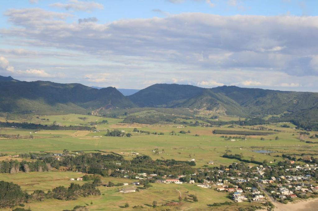
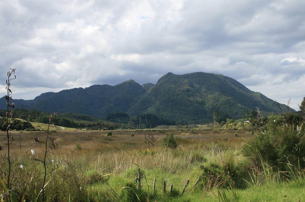
1 Northland Regional Landscape Assessment Worksheet DESCRIPTION AND CHARACTERISATION Component Land Types (refer to list overleaf) Ranges; high relief Unit name HEREKINO BUSH-CLAD HILLS Comment A large, elevated landmass sitting inland of Herekino Harbour and serving to terminate the Tokerau dune flats as the reach Ahipara. High points exceed 550m, and numerous secondary peaks of between m. Geology (including geopreservation sites) Soil Types Ecology (including protected vegetation / features, PNAP Level 1 and 2 sites) An igneous massif of Tangihua Complex rocks, with very steeply sloping flanks and an upper surface dissected by stream valleys. Marine-eroded terrace remnants, including some mantled by deeply leached sands are present at elevations of metres on the northwestern flanks of the massif. Te Kie steepland soils, light brown stony clay loam; Te Kie steepland soils, stony clay loam; Awapuku clay loam. Contains some 18 ecological units and is acknowledged as a large and diverse contiguous habitat with numerous threatened and significant species of flora and fauna. It is the only site in the ecological district where a number of specific forest vegetation associations occur, including taraire-towai-puriri, puriri-taraire-kanuka-towai, kanuka-puriri, kauri-tanekaha-kanuka, secondary kahikatea, as well as the various towai shrubland associations. The site is nationally important because it contains several soils and related vegetation associations of defined types: rendzinas under indigenous vegetation which are nationally uncommon; a moderate range of brown granular clays under indigenous vegetation; and the only example of Dairy Flat soils in the national inventory Archaeological sites Recorded sites tend to be focused around (and outside) the north western edges of this ONL. Heritage Landscapes Landscape characterisation (including the identification of any specific characteristics) A rugged and elevated area of hill country with a heavy and continuous cover of indigenous vegetation. Important as a southern backdrop to Ahipara and natural gateway when approaching from the south via the Hokianga catchment. Portions of the unit are extremely steep and angular, particularly around its south eastern and south western edges, whereas the upper slopes and much of the northern edge of the unit is much more gentle in its contour. Physically, spatially and ecologically related to the Ahipara massif to the west and the Mangataniwha range to the east (with Diggers Valley forming a small divide). Entirely free of built development, but includes some minor access tracks and small pockets of pine. 1
2 EVALUATION Criteria Rank Comment Natural Science Factors Representativeness Natural landscapes are clearly characteristic of the area, district or region. The key components of the landscape will be present in a way that defines the character of the place and distills its character and essence. Endemic associations. Rarity Natural features are unique or rare in the region or nationally, and few comparable examples exist. 3 Distinctive to this area and creating a division between Ahipara / 90 Mile Beach and the northern parts of the Hokianga / Herekino catchment area. Landform and species of vegetation can be broadly seen as being represented elsewhere, but some of the species associations are devoted to this location in relation to the balance of the ecological district and therefore bring a measure of rarity, as do the habitat values provided to a number of threatened and significant species of fauna. Aesthetic Values Coherence The patterns of land cover and land use are largely in harmony with the underlying natural pattern of the landform of the area and there are no significant discordant elements of land cover or land use. 5 Highly unified and cohesive, without compromise by incompatible elements. Diversity & Complexity The elements contributing to overall landscape character are diverse and complex (particularly in ecological terms) without creating disharmony. Vividness Natural features and landscape are widely recognized across the community and beyond the local area and remain clearly in the memory; striking landscapes are symbolic of an area due to their recognisable and memorable qualities. Naturalness How affected by human activity is the landscape? Does human activity intrude on the landscape? Eg. Presence of buildings and associated built development. Presence of infrastructure services. Extent of indigenous forest cover. Homogeneity of exotic vegetation. Presence / extent of modified agricultural land use. Strength of natural processes / ecological patterns. Unmodified and legible physical relief and landform. Presence of water. Intactness Natural systems are intact and aesthetically coherent and do not display significant visual signs of human modification, intervention or manipulation, visually intact and highly aesthetic natural landscapes. 5 A high level of diversity arising from the moderately complex landform involved and the inherent diversity brought by various ecological types and associations. Provides part of a distinctive backdrop to Ahipara and to the experience of travelling to that settlement via the Kaitaia Awaroa Road. These, and likely local perspectives, bring a relatively high level of a vividness. The body of the unit is entirely free of built development and other modifications, although the margins of the landform nearest to Kaitaia are subject to quarrying, masts and pockets of plantation forestry, and these impact upon the naturalness of the associated portion of the ONL. Predominantly intact and cohesive, but with localised impact from nearby activities as outlined above. Experiential Values Expressiveness The legibility of the landscape. Natural features clearly demonstrate the natural processes that formed them. A clearly expressive landscape where ecological influences are readily seen and the most dramatic parts of the landform speak of formative processes. 2
3 Sensory qualities (These are landscape phenomena as directly perceived and experienced by humans, such as the view of a scenic landscape, or the distinctive smell and sound of the foreshore). Transient Values The consistent and repeated occurrence of transient features that contributes to the character, qualities and values of the landscape; landscapes are widely recognised for their transient features and the contribution that these make to the landscape. Remoteness / Wildness Does the landscape display a wilderness character, remote from and untouched by human presence? Eg. Sense of remoteness Accessibility Distance from built development Shared and recognised values Natural features and landscape are widely known and valued by the immediate and wider community for their contribution to a sense of place leading to a strong community association with, or high public esteem for the place. Spiritual, cultural and historical associations Natural features and landscapes can be clearly and widely known and influenced by their connection to the spiritual, cultural and historical valued in the place and includes associative meanings and associative activities valued by the community. Associative meanings are spiritual, cultural or social associations with particular landscape elements, features, or areas, whilst associative activities are patterns of social activity that occur in particular parts of a landscape, for example, popular walking routes or fishing spots. 3 Contributes to the context of Ahipara as a rugged wilderness in the mid distance and to the travelling experience arriving from the south. 2 Reponsive to light conditions primarily. Steep, elevated and apparently largely inaccessible. Tends to sit in the background of views and in relation to road corridors, so brings with it an impression of wilderness and remoteness. Thought to be of importance to Ahipara and Kaitaia, since it forms a mid-distant backdrop to both settlements. The Herekino Forest area generally appears to be not well known (compared to the likes of the Waipoua Forest and Mangataniwha Range). *** Consultation was initiated during the mapping process, but has not led to any feedback within the required period. Rank scale between 1 (low) and 5 (high) Land Types Coastal cliffs / escarpment Low escarpment Bays and headlands Beach Dune complex Reefs and islands Estuarine / inlet Open harbour Coastal plain Rolling hills Steep hills; moderate to high relief Ranges; high relief Strongly rolling land Low rolling land Valley floors and flats Plains Volcanic cones River mouth Wetland Watercourses Lakes and water bodies 3
4 Photographs of unit

5 5

6 6


7 7
Northland Regional Landscape Assessment Worksheet
 Northland Regional Landscape Assessment Worksheet Unit name HURUPAKI VOLCANIC CONE DESCRIPTION AND CHARACTERISATION Component Land Types Volcanic cones land type Comment One of a sequence of volcanic cones,
Northland Regional Landscape Assessment Worksheet
 Northland Regional Landscape Assessment Worksheet Unit name NORTH CAPE DESCRIPTION AND CHARACTERISATION Component Land Types (refer to list overleaf) Coastal cliffs / escarpment Comment A bold, large headland
Northland Regional Landscape Assessment Worksheet
 Northland Regional Landscape Assessment Worksheet Unit name MANGATIPA DESCRIPTION AND CHARACTERISATION Component Land Types (refer to list overleaf) Volcanic cone (remains). Steep hills: moderate high
Northland Regional Landscape Assessment Worksheet
 Northland Regional Landscape Assessment Worksheet DESCRIPTION AND CHARACTERISATION Component Land Types (refer to list overleaf) Coastal cliffs / escarpment Bays and headlands Beach Reefs and islands Unit
Northland Regional Landscape Assessment Worksheet
 Northland Regional Landscape Assessment Worksheet DESCRIPTION AND CHARACTERISATION Component Land Types Central rolling hills; strongly undulating land type Unit name NORTH RIVER AND WAIPU CAVES FORESTS
Northland Regional Landscape Assessment Worksheet
 Northland Regional Landscape Assessment Worksheet DESCRIPTION AND CHARACTERISATION Component Land Types Volcanic cones land type Northern and eastern dissected ranges; high relief land type. Unit name
Northland Regional Landscape Assessment Worksheet
 Northland Regional Landscape Assessment Worksheet Unit / Landscape Ref No. DESCRIPTION AND CHARACTERISATION Component Land Types Northern and eastern dissected ranges; high relief land type Geology (including
fauna ecological unit
 fauna The forested area of this site was surveyed by the NZ Wildlife Service, Fauna Survey Unit in 1977 (SSBI Q08/H012); however, no fauna observations were made. This site is dominated by a relatively
Auckland Council District Plan Hauraki Gulf Islands Section Operative 2013 Proposed plan modification no. 1: Plan Change
 Page 1 Auckland Council District Plan Hauraki Gulf Islands Section Operative 2013 Proposed plan modification no. 1: Plan Change Date of public notification: 31 May 2013 Closing date for submission: 1 July
Map 39 SECTION E: OUTSTANDING COASTAL NATURAL CHARACTER. Legend. Outstanding Coastal Natural Character Areas. Extent of Coastal Environment
 8 289 Legend 1 2 2 3 Extent of Coastal Environment Outstanding Coastal Natural Character Areas 5 Tapuaetahi Bay and Coastline Adjacent Outstanding Coastal Natural Character Areas 4 7 5 6 SECTION E: OUTSTANDING
Coastal Environment. Introduction. 4.1 Coastal Environment. Extent of Coastal Environment
 4 The primary objective (set out in Chapter 2) to be implemented by this Chapter is Objective 2.4 ; the following objectives are also relevant due to the objectives integrated nature: 2.1 Tāngata whenua
Survey no. Q06/111 Survey date 30 April 1997 Grid reference Q ha (153 ha estuary, 53 ha wetland) Altitude sea level
 Altitude sea level") HORAHORA ESTUARY Survey no. Q06/111 Survey date 30 April 1997 Grid reference Q06 456 139 Area 206 ha (153 ha estuary, 53 ha wetland) Altitude sea level Ecological unit (a) Mangrove forest on estuary (b)
HORAHORA ESTUARY Survey no. Q06/111 Survey date 30 April 1997 Grid reference Q06 456 139 Area 206 ha (153 ha estuary, 53 ha wetland) Altitude sea level Ecological unit (a) Mangrove forest on estuary (b)
POUTUKITERANGI PA FOREST REMNANT
 Valley-fill swamp and alluvium in coastal hill country of Waipapa Terrane greywacke (a) Raupo-dominant fertile wetland The wetland is surrounded by pasture except for a small buffer of manuka, totara,
A journey through the earth history of Australia s Coastal Wilderness Part 3 The backdrop - a 70 million year old plain
 A journey through the earth history of Australia s Coastal Wilderness Part 3 The backdrop - a 70 million year old plain Monaro Plain 3. The Cretaceous Plain The western horizon behind Moruya is dominated
Seaton to Seaton Hole SUMMARY OF PREFERRED PLAN RECOMMENDATIONS AND JUSTIFICATION
 Location reference: Policy Unit reference: Plan: Seaton to Seaton Hole 6a29 and 6a30 SUMMARY OF PREFERRED PLAN RECOMMENDATIONS AND JUSTIFICATION The large number of properties and assets at risk in the
Changes in Texas Ecoregions
 Comment On Lesson Changes in Texas Ecoregions The state of Texas can be divided into 10 distinct areas based on unique combinations of vegetation, topography, landforms, wildlife, soil, rock, climate,
Description of Wild Land Area Duirinish Wild Land Area
 22 Duirinish Wild Land Area 1 Context Duirinish is one of the 11 island Wild Land Areas (WLA), one of two on the Isle of Skye. At 43 km 2 it is one of the smallest nationally, located in the far north
Mapping wildness in Scotland s Countryside: a beginner s guide
 Mapping wildness in Scotland s Countryside: a beginner s guide Dr Steve Carver, Wildland Research Institute, University of Leeds The 2007 Perception Survey of Scottish residents carried out by Market Research
Chapter 6, Part Colonizers arriving in North America found extremely landscapes. It looked different to region showing great.
 Social Studies 9 Unit 1 Worksheet Chapter 6, Part 1. 1. Colonizers arriving in North America found extremely landscapes. It looked different to region showing great. 2. The Earth is years old and is composed
Evaluation of the Boundary for the Waiatarua Local Area Plan
 Evaluation of the Boundary for the Waiatarua Local Area Plan 31 July 2009 Version 1 TABLE OF CONTENTS 1.0 STATUTORY CONTEXT LOCAL AREA PLANS... 3 2.0 LOCATION OF LAP BOUNDARY... 3 3.0 DISTINCTIVE COMMUNITIES...
 Page 1 of 9 Name: Base your answer to the question on the diagram below. The arrows show the direction in which sediment is being transported along the shoreline. A barrier beach has formed, creating a
5 Coastal Management
 5 Coastal Management 5 C O A S T A L M A N A G E M E N T 5.1 Introduction Otago s coastal marine area extends from the Waitaki River southwards to Wallace Beach (see Figure 1-1). While the land adjacent
The United States & Canada. A Regional Study of Anglo America
 A Regional Study of Anglo America Landform Regions of the United States & Canada world leaders in agricultural and industrial production because of... VAST LANDS stretch from the Atlantic Ocean on the
Moreton Bay and Key Geographic Concepts Worksheet
 Moreton Bay and Key Geographic Concepts Worksheet The Australian Curriculum: Geography draws on seven key geographic concepts: place scale space environment change interconnection sustainability They are
Chapter 2. Regional Landscapes and the Hydrologic Cycle
 Chapter 2. Regional Landscapes and the Hydrologic Cycle W. Lee Daniels Department of Crop and Soil Environmental Sciences, Virginia Tech Table of Contents Introduction... 23 Soils and landscapes of the
D14. Volcanic Viewshafts and Height Sensitive Areas Overlay
 D14. Volcanic Viewshafts and Height Sensitive Areas Overlay D14.1. Overlay description The purpose of the Volcanic Viewshafts and Height Sensitive Areas Overlay is to appropriately protect significant
Where
 Where What Past Updated Construction Parameters Assumed start date 2030 6 year bulk EW duration plus approx. 1 year enabling works and early construction activities Enabling and early activities includes
Earth s Layers. Earth s Surface
 CHAPTER 1 LESSON 3 Earth s Layers Earth s Surface Key Concepts What are Earth s major landforms and how do they compare? What are the major landform regions of the United States? What do you think? Read
Map 12: Ayrshire Coast: Doonfoot Beach to Dunure Map Content Descriptions
 Map 12: Ayrshire Coast: Doonfoot Beach to Dunure Map Content Descriptions 1. Built Heritage and Archaeology A total of twenty three sites were located in the area covered by Map 12. Of these seventeen
Natural Character Assessment of the Coast Prepared for Marlborough District Council. Coastal Natural Character
 Natural Character Assessment of the Coast Coastal Natural Character September 2011 CONTENTS Background and Introduction... 1 Natural Character Evaluation... 1 Definition of Natural Character... 2 Marlborough
Tuition, Medical and Behaviour Support Service
 Tuition, Medical and Behaviour Support Service Curriculum Policy - Primary Geography Reviewed: October 2018 Next Review: October 2019 Responsibility: Andrea Snow AIMS AND PRINCIPLES The national curriculum
Appendix D ORV Assessment for Clarion River
 Introduction The following ORV assessment criteria were utilized in making WSR eligibility determinations for the 2007 ANF LRMP. These criteria will also be used to assess resource values for the Clarion
Description of Simandou Archaeological Potential Model. 12A.1 Overview
 12A Description of Simandou Archaeological Potential Model 12A.1 Overview The most accurate and reliable way of establishing archaeological baseline conditions in an area is by conventional methods of
Name: Date: Class: Louisiana: Our History, Our Home Chapter 1: Louisiana s Geography - Section 2: Natural Regions Guided Reading
 Instructions: Read the section and complete each item with words from the passages in this section. 1. The diversity of Louisiana s can surprise residents and visitors alike. 2. Physical geography is concerned
Four Mile Run Levee Corridor Stream Restoration
 Four Mile Run Levee Corridor Stream Restoration 30% Design Summary U.S. Army Corps of Engineers, Baltimore District Presentation Outline Four Mile Run 1.) Historic Perspective 2.) Existing Conditions 3.)
Figure 45. Plan of Pukaroro drawn from aerial photograph. K. Jones, drawn by C. Edkins, DOC.
 Figure 45. Plan of Pukaroro drawn from aerial photograph. K. Jones, drawn by C. Edkins, DOC. 101 length, and there are cross-rows forming semi-enclosures. House floors are also present at the southern
Topographic Maps. More than a Road Map
 Topographic Maps More than a Road Map What is a Topographic Map? Scaled representation of features on the surface of the Earth such as roads, rivers, and plains Provides information about land elevations
Candidate Name Centre Number Candidate Number CHANGING PHYSICAL AND HUMAN LANDSCAPES SAMPLE ASSESSMENT MATERIALS
 GCSE GEOGRAPHY Sample Assessment Materials 5 Candidate Name Centre Number Candidate Number 0 GCSE GEOGRAPHY UNIT 1 CHANGING PHYSICAL AND HUMAN LANDSCAPES SAMPLE ASSESSMENT MATERIALS 1 hour 30 minutes Section
Topographic Map Series:
 DEFINITION OF A MAP A MAP IS A GEOGRAPHIC PREPRESENTATION OF A PORTION OF THE EARTH S SURFACE DRAWN TO SCALE, AS SEEN FROM ABOVE. IT S USES COLORS, SYMBOLS AND LABELS TO REPRESENT FEATURES FOUND ON THE
Notes and Summary pages:
 Topographic Mapping 8.9C Interpret topographical maps and satellite views to identify land and erosional features and predict how these shapes may be reshaped by weathering ATL Skills: Communication taking
Terrain Units PALEOGEOGRAPHY: LANDFORM CREATION. Present Geology of NYS. Detailed Geologic Map of NYS
 NYS TOPOGRAPHY Why so? PALEOGEOGRAPHY: LANDFORM CREATION Prof. Anthony Grande AFG 014 Present Geology of NYS Detailed Geologic Map of NYS Generalized Geology Detailed Geology Hot links to the fold out
***When doing the lab report write-up, be sure to follow the guidelines.***
 Topographic Maps Lab Vocabulary: topography - study of the shapes and features of the earth's surface elevation - height above sea level bench mark - a point that has been accurately measured for its position
2.2.7 Backbarrier flats
 FIGURE 24. VERTICAL PHOTOGRAPH SHOWING THE DEVELOPMENT OF SMALL PARABOLIC DUNES FROM BLOWOUTS IN A LARGE RELICT FOREDUNE NORTHWEST OF HUNTER'S CREEK. PHOTOGRAPH COURTESY OF CAR'T'ER HOLT HARVEY FORESTS
The Contested Cultural Landscape of a Lebanese Border Town: MARJA AYOUN
 The Contested Cultural Landscape of a Lebanese Border Town: MARJA AYOUN IBD 2013 FNAS MAY 2013 Dr. Christine Mady, City & Regional Planning NDU -FAAD In this Presentation A PLANNING PERSPECTIVE INTRODUCING
Ecological Land Cover Classification For a Natural Resources Inventory in the Kansas City Region, USA
 Ecological Land Cover Classification For a Natural Resources Inventory in the Kansas City Region, USA by Applied Ecological Services, Inc. In cooperation with the Mid-America Regional Council 600 Broadway,
Map Introduction: South Uist Map 1
 96 Map Introduction: Map This map section covers part of the south coast of, including the head of the causeway which links the island to Eriskay. It extends from South Glen Dale to Taobh a'caolas. There
Ch 10 Deposition Practice Questions
 1. Base your answer to the following question on the data table below. Six identical cylinders, A through F, were filled with equal volumes of sorted spherical particles. The data table shows the particle
3.2.2 Ecological units of the Des Quinze lake proposed biodiversity reserve
 3.2.2 Ecological units of the proposed biodiversity reserve An intact forest mass The proposed biodiversity reserve (see appendix 3) protects terrestrial environments almost exclusively. Proximity of Des
Directed Reading. Section: Types of Maps
 Skills Worksheet Directed Reading Section: Types of Maps 1. What are some of the characteristics of an area shown on maps used by Earth scientists? a. types of animals, types of plants, types of minerals
MARINE GEOLOGY & GEOGRAPHY
 MARINE GEOLOGY & GEOGRAPHY Bathymetry BATHYMETRY BATHYMETRY THE UNDERWATER EQUIVALENT TO TOPOGRAPHY THE STUDY OF WATER DEPTH A BATHYMETRIC MAP SHOWS FLOOR RELIEF OR TERRAIN AS CONTOUR LINES Bathymetry
A physical feature of the Earth s surface
 Earth s Landforms A physical feature of the Earth s surface A physical feature of the Earth s surface LANDFORM Highest of Earth s physical features Highest of Earth s physical features MOUNTAIN Low area
24.0 Mineral Extraction
 Chapter 24 - Mineral Extraction 24.0 Mineral Extraction 24.1 Introduction Apart from gravel, sand, rock, limestone and salt extraction in relatively small quantities mineral extraction is not a strong
Topographic Maps. Take Notes as you view the slides
 Topographic Maps Take Notes as you view the slides Lesson Objectives Define a topographic map and state its uses. Describe how contour lines show the elevations, shape, and slope of the land. Identify
Continental Landscapes
 Continental Landscapes Landscape influenced by tectonics, climate & differential weathering Most landforms developed within the last 2 million years System moves toward an equilibrium Continental Landscapes
Your web browser (Safari 7) is out of date. For more security, comfort and the best experience on this site: Update your browser Ignore
 is out of date. For more security, comfort and the best experience on this site: Update your browser Ignore") Your web browser (Safari 7) is out of date. For more security, comfort and the best experience on this site: Update your browser Ignore ISTHMU S tombolo For the complete encyclopedic entry with media resources,
Your web browser (Safari 7) is out of date. For more security, comfort and the best experience on this site: Update your browser Ignore ISTHMU S tombolo For the complete encyclopedic entry with media resources,
Term Knowledge Using and applying Grade Criteria Autumn 1 Assessment window October Natural hazards pose major risks to people and property.
 Assessment Schedule Year 9 2015/6 Term Knowledge Using and applying Grade Criteria Autumn 1 Assessment window October 2015 3.1.1.2 Tectonic Natural hazards pose major risks to people and property. Definition
Landforms in Canada. Canada is made up of three dis;nct types of landforms: Canadian Shield Highlands Lowlands
 Canada s Landforms What is a Landform? A landform is any physical feature of the Earth s surface having a characteris;c, recognizable shape, produced by natural causes. Landforms include major features
CANADA S LANDFORM REGIONS
 CANADA S LANDFORM REGIONS Canada s Regions Canada is divided into Eight major regions. A Region is an area that is defined on the basis of the presence or absence of certain characteristics: Age of rock
Navigating for Scouts A Self-teaching Guide to Navigation with Map and Compass
 Don Burgess, November 2003 Materials topographic maps Navigating for Scouts A Self-teaching Guide to Navigation with Map and Compass metric ruler orienteering compass 30 M/5 Hamilton-Burlington 41 I/13
Social Studies 9 UNIT 2 GEOGRAPHIC INFLUENCES ON IDENTITY: PLACE AND PEOPLE
 Social Studies 9 UNIT 2 GEOGRAPHIC INFLUENCES ON IDENTITY: PLACE AND PEOPLE The Structure of the Earth To understand the forces that create Canada's physical landscape we must understand the structure
Unit 7.2 W.E.D. & Topography Test
 Name: Score: Unit 7.2 W.E.D. & Topography Test 1. 2. 3. 4. 5. 6. 7. 8. 9. 10. 11. 12. 13. 14. 15. 16. 17. 18. 19. 20. 21. 22. 23. 24. 25. 1. The formation of mountains is due mainly to while the destruction
D14. Volcanic Viewshafts and Height Sensitive Areas Overlay
 D14. Volcanic Viewshafts and Height Sensitive Areas Overlay D14.1. Overlay description The purpose of the Volcanic Viewshafts and Height Sensitive Areas Overlay is to appropriately protect significant
56H. This system allows definition of points on the Earth s surface to within 100 meters. Page 20. Navigation Systems Basics of Maps
 Grid References Many maps are provided with the standard grid overlaying them. This provides a simple and accurate method for finding features on the map. It is a network of intersecting parallel lines
Hiking the Bold Coast, Cutler, Maine
 Maine Geologic Facts and Localities June, 2010 Hiking the Bold Coast, Cutler, Maine 44 o 39 36.34 N, 67 o 12 46.99 W Text by Robert A. Johnston, Department of Agriculture, Conservation & Forestry 1 Map
Laboratory Exercise #4 Geologic Surface Processes in Dry Lands
 Page - 1 Laboratory Exercise #4 Geologic Surface Processes in Dry Lands Section A Overview of Lands with Dry Climates The definition of a dry climate is tied to an understanding of the hydrologic cycle
PATAUA ESTUARY REMNANTS
 Occasional species include tawapou, ti kouka, karaka, kahikatea, ponga, mahoe and whau. (c) The remnants to the east along the coast consist of kanuka/manuka pohutukawa coastal forest, with the occasional
Physical Geology, 15/e
 Lecture Outlines Physical Geology, 15/e Plummer, Carlson & Hammersley Deserts & Wind Action Physical Geology 15/e, Chapter 13 Deserts Desert any arid region that receives less than 25 cm of precipitation
WJEC Eduqas GCSE (9-1) GEOGRAPHY B
 GEOGRAPHY B") WJEC Eduqas GCSE (9-1) GEOGRAPHY B Additional sample questions for Theme 2 Candidate name.. Question Mark (a) (i) /2 (a) (ii) /4 (a) (iii) /4 (a) (iv) /3 (b) (i) /4 (b) (ii) /6 (c) (i) /2 (c) (ii) /1 (c)
WJEC Eduqas GCSE (9-1) GEOGRAPHY B Additional sample questions for Theme 2 Candidate name.. Question Mark (a) (i) /2 (a) (ii) /4 (a) (iii) /4 (a) (iv) /3 (b) (i) /4 (b) (ii) /6 (c) (i) /2 (c) (ii) /1 (c)
Changes to Land 5.7B. landforms: features on the surface of Earth such as mountains, hills, dunes, oceans and rivers
 All the landforms on Earth have changed over time and continue to change. Many of the changes were caused by wind, moving water, and moving ice. Mountains have grown and shrunk. Rivers have cut away land
discussion of North America s physical features, including its landforms and bodies of
 Chapter 7 Natural Environments of North America Chapter 7 focuses on the natural environments of North America. The chapter opens with a discussion of North America s physical features, including its landforms
CHAPTER 28. PHYSIOGRAPHY Cook Inlet Drainages
 PEBBLE PROJECT ENVIRONMENTAL BASELINE DOCUMENT 2004 through 2008 CHAPTER 28. PHYSIOGRAPHY Cook Inlet Drainages PREPARED BY: Knight Piésold Ltd. PHYSIOGRAPHY COOK INLET DRAINAGES TABLE OF CONTENTS TABLE
Natural hazards in Glenorchy Summary Report May 2010
 Natural hazards in Glenorchy Summary Report May 2010 Contents Glenorchy s hazardscape Environment setting Flood hazard Earthquakes and seismic hazards Hazards Mass movement Summary Glossary Introduction
CRITERIA FOR THE ASSESSMENT OF OUTSTANDING UNIVERSAL VALUE
 CRITERIA FOR THE ASSESSMENT OF OUTSTANDING UNIVERSAL VALUE Workshop of National Focal Points of Central, South-East and Eastern European Countries on the Preparation of the Second Cycle of the Periodic
Physical landscapes River landscapes in the UK
 Physical landscapes River landscapes in the UK The shape of river valleys change s as rivers flow downstream - PROCESSES Erosion Abrasion or corrasion Attrition Hydraulic Action Solution or corrosion Deposition
Think about the landforms where you live. How do you think they have changed over time? How do you think they will change in the future?
 reflect All the landforms on Earth have changed over time and continue to change. Many of the changes were caused by wind, moving water, and moving ice. Mountains have grown and shrunk. Rivers have cut
Unit 1: Geography. For additional information, refer to this website: 1 G e o g r a p h y
 Unit 1: Geography For additional information, refer to this website: http://mryoungtms.weebly.com/ 1 G e o g r a p h y Continents and Oceans SOL USI. 2a Essential Understanding: Continents are large land
Page 1. Name:
 Name: 1) Which event is the best example of erosion? dissolving of rock particles on a limestone gravestone by acid rain breaking apart of shale as a result of water freezing in a crack rolling of a pebble
2. PHYSICAL FEATURES OF INDIA
 2. PHYSICAL FEATURES OF INDIA Question 1: Choose the right answer from the four alternatives given below. (i) A landmass bound by sea on three sides is referred to as (a) Coast (c) Peninsula (b) Island
What landforms make up Australia?!
 What landforms make up Australia? The tectonic forces of folding, faulting and volcanic activity have created many of Australia's major landforms. Other forces that work on the surface of Australia, and
Topography the natural and human features of the Earth s surface. ie. Surface features need to understand difference between relief and elevation
 Chapter 1 Landform Patterns and Processes Highlighted script will not be assessed Topography the natural and human features of the Earth s surface. ie. Surface features need to understand difference between
depression above scarp scarp
 1 LAB 1: FIELD TRIP TO McKINLEYVILLE AND MOUTH OF THE MAD RIVER OBJECTIVES: a. to look at geomorphic and geologic evidence for large scale thrust-faulting of young sediments in the Humboldt Bay region
Chapter 6. Field Trip to Sandia Mountains.
 University of New Mexico Biology 310L Principles of Ecology Lab Manual Page -40 Chapter 6. Field Trip to Sandia Mountains. Outline of activities: 1. Travel to Sandia Mountains 2. Collect forest community
Local Area Key Issues Paper No. 13: Southern Hinterland townships growth opportunities
 Draft Sunshine Coast Planning Scheme Review of Submissions Local Area Key Issues Paper No. 13: Southern Hinterland townships growth opportunities Key Issue: Growth opportunities for Southern Hinterland
M w 9.0 Tonga-Kermadec subduction zone scenario
 4.3.3. M w 9.0 Tonga-Kermadec subduction zone scenario The arrival times of the first and maximum waves (as calculated by the method outlined in section 4.1) for the tsunami generated by a M w 8.5 subduction
Topographical Maps ANSWER KEY- Assignment 6
 Topographical Maps ANSWER KEY- Assignment 6 Question 1 (To be answered using toposheet 45 D/7, Grid reference 76 to 85) 1. Cite two differences between the Sipu River and the Mahadeviyo Nala? Sipu River
Science EOG Review: Landforms
 Mathematician Science EOG Review: Landforms Vocabulary Definition Term canyon deep, large, V- shaped valley formed by a river over millions of years of erosion; sometimes called gorges (example: Linville
UNIT 3 GEOLOGY VOCABULARY FLASHCARDS THESE KEY VOCABULARY WORDS AND PHRASES APPEAR ON THE UNIT 3 CBA
 UNIT 3 GEOLOGY VOCABULARY FLASHCARDS THESE KEY VOCABULARY WORDS AND PHRASES APPEAR ON THE UNIT 3 CBA A map that shows Earth s Topographic Map surface topography, which is Earth s shape and features Contour
The Systems Approach. Alun Williams, ABPmer
 The Systems Approach Alun Williams, ABPmer Overview What is A Systems Approach? Behavioural / Qualitative Modelling? System Definition / Mapping (Behavioural Statements Objective) What is a Systems Approach?
1/28/16. EGM101 Skills Toolbox. Map types. Political Physical Topographic Climate Resource Road. Thematic maps (use one of the above as backdrop)
") EGM101 Skills Toolbox Map types Political Physical Topographic Climate Resource Road Thematic maps (use one of the above as backdrop) Map Types Deriving information from maps Hydrographic Geological Soils
EGM101 Skills Toolbox Map types Political Physical Topographic Climate Resource Road Thematic maps (use one of the above as backdrop) Map Types Deriving information from maps Hydrographic Geological Soils
Landscape evolution. An Anthropic landscape is the landscape modified by humans for their activities and life
 Landforms Landscape evolution A Natural landscape is the original landscape that exists before it is acted upon by human culture. An Anthropic landscape is the landscape modified by humans for their activities
2 Georgia: Its Heritage and Its Promise
 TERMS region, erosion, fault, elevation, Fall Line, aquifer, marsh, climate, weather, precipitation, drought, tornado, hurricane, wetland, estuary, barrier island, swamp PLACES Appalachian Mountains, Appalachian
Regional Atlas Activity C
 Political Location Activity AUSTRALIA, OCEANIA, AND ANTARCTICA Regional Atlas Activity C DIRECTIONS: Identify each country marked by a number on the map. Then write the correct name on the numbered blanks
4. The map below shows a meandering stream. Points A, B, C, and D represent locations along the stream bottom.
 1. Sediment is deposited as a river enters a lake because the A) velocity of the river decreases B) force of gravity decreases C) volume of water increases D) slope of the river increases 2. Which diagram
Introduction to the Gozo & Comino Local Plan
 Introduction to the Gozo & Comino Local Plan What is a Local Plan? A Local Plan is a land use document with written text (policies and justifications) and maps; Reconciles local needs with strategic considerations;
EROSIONAL FEATURES. reflect
 reflect Have you ever looked at the land around you and wondered what processes shaped what you see? Perhaps you see mountains, valleys, rivers, or canyons. Do you know how long these geologic features
Erosional Features. What processes shaped this landscape?
 Have you ever looked at the land around you and wondered what processes shaped what you see? Perhaps you see mountains, valleys, rivers, or canyons. Do you know how long these geologic features have been
Locating Potential Archaeology Sites in Aomori, Japan Using Predicative and Maximum Entropy Modeling
 Locating Potential Archaeology Sites in Aomori, Japan Using Predicative and Maximum Entropy Modeling William Goldby LA 221 Tessa Beach Amna Alruheili Final White Paper 13 May 2014 Locating Potential Archaeology
Phillip Island Nature Parks Coastal Process Study 8 October 2014
 Phillip Island Nature Parks Coastal Process Study 8 October 2014 Project Overview Coastal Geology Basaltic and fragmented lavas, granite at Pyramid Rock and Cape Woolamai Weathered basalt (>10m thick)
Geology 101 Lab Worksheet: Topographic Maps
 Geology 101 Lab Worksheet: Topographic Maps Name: Refer to the Topographic Maps Lab for the information you need to complete this worksheet (http://commons.wvc.edu/rdawes/g101ocl/labs/topomapslab.html).
CHAPTER EXIT CHAPTER. Models of Earth. 3.1 Modeling the Planet. 3.2 Mapmaking and Technology. 3.3 Topographic Maps CHAPTER OUTLINE
 EXIT CHAPTER.1 Modeling the Planet.2 Mapmaking and Technology. Topographic Maps CHAPTER OUTLINE CHAPTER.1 Modeling the Planet A flat of Earth is a convenient tool, but it can distort the shape, distance,