Characterization of Southern Florida Marsh Vegetation Using a Landscape Scale Random Sample: R-EMAP Phase III Vegetation Sampling.
|
|
|
- Meghan Hood
- 5 years ago
- Views:
Transcription


1 Characterization of Southern Florida Marsh Vegetation Using a Landscape Scale Random Sample: R-EMAP Phase III Vegetation Sampling. Jennifer H. Richards 1 Tom Philippi 1 P. Kalla 2 and D. Scheidt 3 1 Dept. of Biological Sciences, Florida International University, Miami, FL 2 U.S Environmental Protection Agency, Region 4, Science and Ecosystem Support Division, Athens, GA 3 U.S. Environmental Protection Agency, Region 4, Water Management Division, Athens, GA
2 R-EMAP Sampling Design Sampled 111 sites in spring 25, 119 sites in fall 25, 23 total Parameters sampled at each site, where possible: Biogeochemical (soil, surface and pore-water nutrients/mercury/physical parameters) Plant species presence and vegetation mapping Fish (fall only) Invertebrates (fall only) Periphyton (fall only)


3 Plant Species Sampling Plant Community Analysis Exotic Plant Species Surveys Survey on fly-in Survey from helicopter pontoons
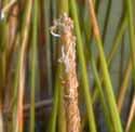
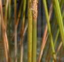
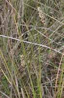
4 Plant Community Analysis: Species presence in 2 (¼ m 2 ) quadrats distributed along 1 m N-S transect 5 m west of sampling point Additional transect to reflect additional diversity within 5m radius at site Sawgrass density counted and l x w of longest leaf measured in 3rd m 2
5


6 Transect 1 Transect 2 2 (.25) m 2 quadrats S N Sawgrass density
7 Plant Community Analysis 23 sites visited (111 spring, 119 fall) 114 sites had transect species encountered (including 4 unknowns) 173 on transect 1 16 on transect 2 14 species present on transect 2 but not on transect 1
8 Species Occurrence, Transect taxa distributed among 23 sites (111 spring, 119 fall) Sawgrss (Cladium jamaicense) Frequency Two species of Utricularia These 133 species (77%) occurred at 1 or fewer sites Species
9 Agglomerative hierarchical clustering of primary transect data: 5 groups recognized Information Remaining (%) s128 s4 s143 s16 s138 s257 s15 s2 s13 s132 s142 s153 s131 s258 s136 s137 s14 s154 s11 s1 s18 s2 s13 s15 s3 s36 s41 s5 s135 s18 s165 s16 s253 s174 s15 s217 s229 s87 s93 s181 s182 s81 s56 s187 s185 s157 s1 s7 s7 s162 s166 s171 s367 s25 s14 s112 s163 s47 s17 s59 s189 s26 s216 s51 s195 s227 s254 s183 s24 s75 s252 s37 s177 s43 s219 s228 s16 s224 s95 s12 s67 s94 s226 s66 s23 s1 s239 s244 s176 s234 s9 s186 s191 s2 s197 s28 s223 s233 s11 s89 s145 s123 s22 s65 s24 s85 s48 s18 s249 s119 s364 s147 s178 s148 s152 s192 s118 s199 s194 s251 s193 s211 s215 s221 s238 s73 s8 s83 s68 s77 s156 s97 s218 s231 s82 s99 s179 s86 s84 s21 s22 s235 s19 s121 s236 s488 s115 s23 s12 s141 s124 s214 s37 s169 s27 s64 s14 s11 s151 s31 s222 s91 s155 s35 s351 s19 s17 s161 s21 s144 s23 s158 s32 s167 s17 s26 s27 s149 s39 s24 s29 s38 s12 s122 s146 s159 s213 s255 s198 s88 s3 s33 s4 s172 s28 s55 s49 s69 s76 s53 s57 s173 s188 s54 s368 s175 s237 s184 s242 s245 s374 s117 s114 s19 s96 s35 s225 s25 s212 s61 s72 s74 s365 s45 s63 s46 s52 s62 s58 s366 Muhlenbergia Cladium Typha Eleocharis Nymphaea (muhly) (sawgrass) (cattail) (spikerush) (water lily)


10 Muhly group is most species rich: 28 sites, 47 species, 41 significant indicator species; But note, also, sawgrass is present at 1% of these sites Species IV % p Muhly group Muhlenbergia capillaris Panicum tenerum Centella asiatica Symphyotrichum bracei Pluchea rosea Rhynchospora microcarpa Solidago stricta Cassytha filiformis Schizachyrium rhizomatum Polygala grandiflora


11 Sawgrass group is most common but is species poor: 12 sites, 7 species, 2 significant indicator species; Species IV % p Sawgrass group Cladium jamaicense Cephalanthus occidentalis


12 Spikerush group is next most abundant and diverse: 52 sites, 18 species, 8 significant indicator species; Species IV % p Spikerush group Eleocharis cellulosa Bacopa caroliniana Rhynchospora tracyi Panicum hemitomon Sagittaria lancifolia Paspalidium geminatum Rhynchospora inundata Justicia angusta

13 Water lily group has floating-leaved and submerged or free-floating aquatics 29 sites, 1 species, 6 significant indicator species, including 3 rootless, aquatic bladderwort species Species IV % p Water lily group Nymphaea odorata Utricularia purpurea Utricularia gibba Eleocharis elongata Nymphoides aquatica Utricularia foliosa


14 Cattail group is least abundant 19 sites, 1 species, 6 significant indicator species, including exotics, shrubs and vines Species IV % p Cattail group Typha domingensis Polygonum hydropiperoides Salix caroliniana Sarcostemma clausum Salvinia minima Pontederia cordata

15 NMS Ordination of Sites: 3Dimensions with 8% of information; groups separate but with overlap Muhly group Sawgrass group Cattail group Spikerush group Water Lily group
16 Muhly group is very distinct; 8 Cattail group is dispersed; Axis 2 Sawgrass, spikerush and water lily groups overlap but occupy different sectors of ordination space Axis Muhly group Sawgrass group Cattail group Spikerush group Water Lily group Axis 3 4 Axis Axis 2 Axis 1
17 Species distributions among clusters reflect both overlap and distinctions among groups Muhly group Sawgrass group Cattail group Spikerush group Water Lily group Axis Axis Cladium 4 8 Axis Axis 1 Nymphaea 8 8 Axis 3 4 Axis 3 4 Muhlenbergia Eleocharis 4 8 Axis Axis 1
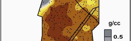
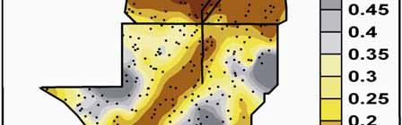
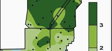
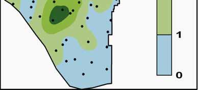
18 Four environmental variables, r 2 >.2, correlate most strongly to a single axis 8 DSDTN WSD Soil Variables Thickness ph Bulk Density* Ash Free Dry Weight* Total P Total N* Total C* Axis 3 4 BD Hydrology Variables Wet Season Water Depth* Dry Season Water Depth* Average Hydroperiod No. Week-long Drydowns 4 8 Axis 1 Muhly group Sawgrass group Cattail group Spikerush group Water Lily group

")


19 (Scheidt and Kalla 27) (Scheidt & Kalla 27)
20 But Total P in soil correlates to another axis, r 2 =.39 8 Soil Variables Thickness ph Bulk Density Ash Free Dry Weight Total P* Total N Total C Axis 2 4 TP Hydrology Variables Wet Season Water Depth Dry Season Water Depth Average Hydroperiod No. Week-long Drydowns 4 8 Axis 1 Muhly group Sawgrass group Cattail group Spikerush group Water Lily group
21 Combined correlations for the environmental variables are seen in the third dimension 8 DSD TN WSD Soil Variables Thickness ph Bulk Density* Ash Free Dry Weight Total P* Total N* Total C* Axis 3 4 TP Hydrology Variables Wet Season Water Depth* Dry Season Water Depth* Average Hydroperiod No. Week-long Drydowns BD 4 8 Axis 2 Muhly group Sawgrass group Cattail group Spikerush group Water Lily group
22 Removing outliers removes TP as a significant correlate, reduces axes to 2D, changes species composition of the cattail group and classifies more sites in the water lily group Axis BD TC AFDW WSDSD TN Soil Variables Thickness ph Bulk Density* Ash Free Dry Weight* Total P Total N* Total C* Hydrology Variables Wet Season Water Depth* Dry Season Water Depth* Average Hydroperiod Maximum Hyrdroperiod No. Week-long Drydowns 4 8 Axis 1 Muhly group Sawgrass group Cattail group Spikerush group Water Lily group

23 Species Distributions Across the Landscape
24 The Everglades is the River of (Saw)Grass
25 Sawgrass morphology and culm density have unimodal (not bimodal) distributions; morphology but not density varies across the landscape Sawgrass Leaf Length vs. Density by Region Sawgrass Leaf Length by Region Length of Longest Leaf (cm) y =.929x R 2 =.13 y =.6973x R 2 =.359 Sawgrass, ENP Sawgrass, north Culms per m 2 Length of Longest Leaf (cm) a b ENP LOX WCA2, 3 b


26 Other common species are unevenly distributed

27


28 White water lily is sparse in ENP
29 Conclusions Everglades marsh plant associations can be broadly delimited into 5 communities that separate out along a hydrologic gradient The muhly and water lily groups are distinct and form the end-points of this environmental gradient; muhly and water lily make good indicator species for these groups. The other species associations show lots of overlap and grade into each other along the hydrologic gradient 8 DSDTN WSD Axis 3 4 BD 4 8 Axis 1

30 Conclusions A cattail association varies along a separate environmental gradient that correlates with soil TP; this association has sites that are both natural and nutrient impacted. Axis TP DSD TN WSD BD Sawgrass shows broad tolerances of hydrological and biogeochemical conditions and is present and abundant throughout the entire Everglades, whereas other species have more restricted distributions. 4 8 Axis 2 Both water lily distribution and sawgrass morphology reflect on a landscape scale the drier, shallower environment in ENP as compared to the WCAs; these conditions should change with restoration.


31 Acknowledgements Paul Groff, Diana Van Dillewijn, Ana Castellanos, Walter Zagarra, Marlene Dow Morris Flexner, Chris Decker, and the rest of the EPA plant sampling team The Institute for Regional Conservation
Big Red Fish / Walton
 Aquatic plant data collected on July 26, 2000 Big Red Fish / Walton Percent area covered with aquatic vegetation (PAC, %). Percent of lake's volume filled with vegetation (PVI, %). Average emergent plant
Rapid Periphyton Survey 2014 Biocriteria Meeting Variability Study Results. Q Meeting March 26, 2015 Meghann Niesen
 Rapid Periphyton Survey 2014 Biocriteria Meeting Variability Study Results Q Meeting March 26, 2015 Meghann Niesen Rapid Periphyton Survey (RPS) Measures extent and thickness of attached algae at 99 points
TECHNICAL PUBLICATION #87-3
 TECHNICAL PUBLICATION #87-3 April 1987 VEGETATION CHANGES IN THE LAKE OKEECHOBEE LITTORAL ZONE 1972 TO 1982 This publication was produced at an annual cost of $153.75 or $.31 per copy to inform the public.
Ecological Patterns and Processes in Ghost Tree Islands of the Everglades
 Ecological Patterns and Processes in Ghost Tree Islands of the Everglades Sharon M. L. Ewe 1, Binhe Gu 2, Jennifer Vega 1 and Kristin Vaughan 1 1 Ecology and Environment Inc., 12300 South Shore Blvd, Wellington,
Floristic Quality Index: Current Methods and Development. Nia Wellendorf Russ Frydenborg DEP Bureau of Labs
 Floristic Quality Index: Current Methods and Development Nia Wellendorf Russ Frydenborg DEP Bureau of Labs Outline History and definition of FQI Methods developed for Florida lakes Ongoing index development
Table 1. Physical Characteristics of Your Lake.
 The lake assessments are created in partnership with Hillsborough County and the Florida Center for Community Design and Research LAKE ASSESSMENT DOCUMENT Lake assessments are being conducted to contribute
Aquatic Botany 95 (2011) Contents lists available at ScienceDirect. Aquatic Botany. journal homepage:
 Contents lists available at ScienceDirect. Aquatic Botany. journal homepage:") Aquatic Botany 95 (2011) 9 16 Contents lists available at ScienceDirect Aquatic Botany journal homepage: www.elsevier.com/locate/aquabot Experimental determination of effects of water depth on Nymphaea
Aquatic Botany 95 (2011) 9 16 Contents lists available at ScienceDirect Aquatic Botany journal homepage: www.elsevier.com/locate/aquabot Experimental determination of effects of water depth on Nymphaea
Hydroecological factors governing surface water flow on a low-gradient floodplain
 Click Here for Full Article WATER RESOURCES RESEARCH, VOL. 45, W03421, doi:10.1029/2008wr007129, 2009 Hydroecological factors governing surface water flow on a low-gradient floodplain Judson W. Harvey,
Systematic Vegetation Survey Development of a Floristic Quality Index for Florida Lakes
 Systematic Vegetation Survey Development of a Floristic Quality Index for Florida Lakes Russel Frydenborg Florida Dept. Environmental Protection Bureau of Laboratories Florida Wetland Bioassessment Contract
Landscape-scale trends and. Islands in the Everglades. Sharon M. L. Ewe, Binhe Gu, Jennifer Vega, Kristin Vaughan, Sumanjit Aich
 Landscape-scale trends and patterns of Ghost Tree Islands in the Everglades Sharon M. L. Ewe, Binhe Gu, Jennifer Vega, Kristin Vaughan, Sumanjit Aich What is a Ghost island? Ghost island is a tree island
Landscape Pattern- Ridge, Slough, and Tree Island Mosaics. Cooperative Agreement #: W912HZ Year-3 Report ( ) Submitted to:
 Submitted to:") Landscape Pattern- Ridge, Slough, and Tree Island Mosaics Cooperative Agreement #: W912HZ-10-2-0030 Year-3 Report (2010-2013) Submitted to: Dr. Al F. Cofrancesco U.S. Army Engineer Research and Development
Landscape Pattern- Ridge, Slough, and Tree Island Mosaics Cooperative Agreement #: W912HZ-10-2-0030 Year-3 Report (2010-2013) Submitted to: Dr. Al F. Cofrancesco U.S. Army Engineer Research and Development
Table 1: 2012 Aquatic Plant Community Statistics, Fish Lake, Dane County, WI Aquatic Plant Community Statistics 2012
 APPENDIX A FISH LAKE PLANT STATISTICS (2012) Table 1: 2012 Aquatic Plant Community Statistics, Fish Lake, Dane County, WI Aquatic Plant Community Statistics 2012 Number of sites sampled 474 Number of sites
Everglades Ridge, Slough, and Tree Island Mosaics: Year 2 Annual Report
 Florida International University FIU Digital Commons SERC Research Reports Southeast Environmental Research Center 2010 Everglades Ridge, Slough, and Tree Island Mosaics: Year 2 Annual Report Michael S.
Marl Prairie vegetation response to 20th century land use and its implications for management in the Everglades
 Marl Prairie vegetation response to 20th century land use and its implications for management in the Everglades C. Bernhardt, D. Willard, B. Landacre US Geological Survey Reston, VA USA U.S. Department
Landscape Pattern- Ridge, Slough, and Tree Island Mosaics. Cooperative Agreement #: W912HZ Year-5 Report ( ) Submitted to:
 Submitted to:") Landscape Pattern- Ridge, Slough, and Tree Island Mosaics Cooperative Agreement #: W912HZ-10-2-0030 Year-5 Report (2010-2015) Submitted to: Dr. Glenn Rhett U.S. Army Engineer Research and Development Center
Landscape Pattern- Ridge, Slough, and Tree Island Mosaics Cooperative Agreement #: W912HZ-10-2-0030 Year-5 Report (2010-2015) Submitted to: Dr. Glenn Rhett U.S. Army Engineer Research and Development Center
ATLSS SESI MODEL: Long-Legged and Short-Legged Wading Birds: Foraging Indices
 ATLSS SESI MODEL: Long-Legged and Short-Legged Wading Birds: Foraging Indices Louis J. Gross, University of Tennessee ATLSS.org Provides a relative estimate of quality of pixels as sites for nesting colonies
Water Management and Hydrology of Northeast Shark River Slough from 1940 to 2015
 Water Management and Hydrology of Northeast Shark River Slough from 1940 to 2015 Greater Everglades Ecosystem Restoration Conference April 2015 Kevin Kotun, Hydrologist Physical Resources Branch South
Aquatic Plant Community of Crooked Lake: 2017 Anoka County, MN (# )
") Aquatic Plant Survey Crooked Lake (Anoka County, MN) August 07 577 Creekside Lane Osseo, MN 5569 james@freshwatersci.com (65) 6-8696 Aquatic Plant Community of Crooked Lake: 07 Anoka County, MN (#0-008)
Aquatic Plant Survey Crooked Lake (Anoka County, MN) August 07 577 Creekside Lane Osseo, MN 5569 james@freshwatersci.com (65) 6-8696 Aquatic Plant Community of Crooked Lake: 07 Anoka County, MN (#0-008)
Assessing researcher impacts from a long-term sampling program of wetland communities in the Everglades National Park, Florida, U.S.A.
 Freshwater Biology (2004) 49, 1381 1390 doi:10.1111/j.1365-2427.2004.01256.x APPLIED ISSUES Assessing researcher impacts from a long-term sampling program of wetland communities in the Everglades National
Wetlands in a Watershed/Landscape Context Vegetation & Wildlife August 15, Kendra Moseley, Regional ESS, Soil Science Division
 Wetlands in a Watershed/Landscape Context Vegetation & Wildlife August 15, 2018 - Kendra Moseley, Regional ESS, Soil Science Division Vegetation in Wetlands Vegetation as an Indicator of Hydrology Vegetation
Consulting Services to Determine the Effectiveness of Vegetation Classification Using WorldView 2 Satellite Data for the Greater Everglades
 Florida International University FIU Digital Commons GIS Center GIS Center 2-2-2012 Consulting Services to Determine the Effectiveness of Vegetation Classification Using WorldView 2 Satellite Data for
This article appeared in a journal published by Elsevier. The attached copy is furnished to the author for internal non-commercial research and
 This article appeared in a journal published by Elsevier. The attached copy is furnished to the author for internal non-commercial research and education use, including for instruction at the authors institution
Effect of Hydrologic Restoration on the Habitat of The Cape Sable Seaside Sparrow, Annual Report of
 Florida International University FIU Digital Commons SERC Research Reports Southeast Environmental Research Center 6-30-2003 Effect of Hydrologic Restoration on the Habitat of The Cape Sable Seaside Sparrow,
Environmental Science
 Environmental Science A Study of Interrelationships Cui Jiansheng Hebei University of Science and Technology CH06 Kinds of Ecosystems and Communities Chapter Objectives After reading this chapter, you
Response of the Everglades ridge and slough landscape to climate variability and 20th-century water management
 Ecological Applications, 19(7), 2009, pp. 1723 1738 Ó 2009 by the Ecological Society of America Response of the Everglades ridge and slough landscape to climate variability and 20th-century water management
Field Guide. To The Aquatic Plants of. Cobbett s Pond. May Improvement Association. Prepared for: Prepared by:
 To The Aquatic Plants of Cobbett s Pond May 2010 Prepared for: Cobbett s Pond Improvement Association Prepared by: 289 Great Rd., Acton, MA 01720 (978) 263-9588 This to the Aquatic Plants of Cobbett s
Patterns of impact of three invasive plant species on freshwater ecosystems
 Patterns of impact of three invasive plant species on freshwater ecosystems Iris Stiers & Ludwig Triest Vrije Universiteit Brussel, Plant Biology and Nature Management, BELGIUM freshwater ecosystem WITHOUT
Other Ingredients: % Total: %
 Supplemental Label Aquatic Weeds Controlled This supplemental label expires December 31, 2014, and must not be used or distributed after this date. Active Ingredient: ammonium salt of imazamox: 2-[4,5-dihydro-4-methyl-4-(1-methylethyl)-5-oxo-1Himidazol-2-yl]-5-(methoxymethyl)-3-pyridinecarboxylic
PINE LAKE AQUATIC PLANT SURVEY PINE LAKE, HILES WISCONSIN DECEMBER 2016 PO BOX 273 PARK FALLS, WI
 PINE LAKE AQUATIC PLANT SURVEY PINE LAKE, HILES WISCONSIN DECEMBER 2016 PO BOX 273 PARK FALLS, WI 54552 715.965.3489 TIFFINEY@FLAMBEAUENGINEERING.COM PINE LAKE AQUATIC PLANT SURVEY An aquatic plant survey
This supplemental label expires December 31, 2014, and must not be used or distributed after this date.
 Supplemental Label Clearcast HERBICIDE EPA Reg. No. 241-437-67690 This supplemental label expires December 31, 2014, and must not be used or distributed after this date. Active Ingredient: ammonium salt
Lake Vermilion ( ) Aquatic Vegetation Survey
 Aquatic Vegetation Survey") Lake Vermilion (69-0378 - 00) Aquatic Vegetation Survey 22796 County Highway 6 Detroit Lakes, MN 56501 (218) 846-1465 www.rmbel.info Table of Contents Executive Summary... 3 Introduction... 4 Methods...
Lake Vermilion (69-0378 - 00) Aquatic Vegetation Survey 22796 County Highway 6 Detroit Lakes, MN 56501 (218) 846-1465 www.rmbel.info Table of Contents Executive Summary... 3 Introduction... 4 Methods...
Reading the landscape: temporal and spatial changes in a patterned peatland
 Wetlands Ecol Manage (211) 19:475 493 DOI 1.17/s11273-11-9229-z ORIGINAL PAPER Reading the landscape: temporal and spatial changes in a patterned peatland M. K. Nungesser Received: 29 June 29 / Accepted:
Chapter 52 An Introduction to Ecology and the Biosphere
 Chapter 52 An Introduction to Ecology and the Biosphere Ecology The study of the interactions between organisms and their environment. Ecology Integrates all areas of biological research and informs environmental
Organism Interactions in Ecosystems
 Organism Interactions in Ecosystems Have you ever grown a plant or taken care of a pet? If so, you know they have certain needs such as water or warmth. Plants need sunlight to grow. Animals need food
TEST NAME: Biome Test 10/7 TEST ID: GRADE:05 - Fifth Grade SUBJECT:Life and Physical Sciences TEST CATEGORY: My Classroom
 TEST NAME: Biome Test 10/7 TEST ID:1239163 GRADE:05 - Fifth Grade SUBJECT:Life and Physical Sciences TEST CATEGORY: My Classroom Biome Test 10/7 Page 1 of 8 10/07/16, Biome Test 10/7 Student: Class: Date:
FIU Digital Commons. Florida International University. Ding He Florida International University,
 Florida International University FIU Digital Commons FIU Electronic Theses and Dissertations University Graduate School 6-25-2014 Application of Biomarkers and Compound Specific Stable Isotopes for the
Connectivity Between the Mangrove Ecotone Region and Florida Bay: Current Understanding in Carbon and Nutrient Fluxes
 Connectivity Between the Mangrove Ecotone Region and Florida Bay: Current Understanding in Carbon and Nutrient Fluxes Victor H. Rivera-Monroy, Stephen E. Davis III, Robert R. Twilley, Daniel L. Childers,
The Role of the Mangrove Ecotone Region in Regulating Nutrient Cycling and Wetland Productivity in South Florida
 The Role of the Mangrove Ecotone Region in Regulating Nutrient Cycling and Wetland Productivity in South Florida Victor H. Rivera-Monroy, Stephen E. Davis III, Robert R. Twilley, Daniel L. Childers, Marc
Types of Wetlands. Tidal Systems
 Types of Wetlands Tidal Systems 1 COASTAL WETLAND ECOSYSTEMS Tidal Salt Marshes Tidal Freshwater Marshes Mangrove Wetlands 2 Tidal Estuarine Wetland 3 Definition and Formation of Estuaries Estuary: : partially
Subtidal permanently flooded with tidal water. Irregularly exposed surface exposed by tides less often than daily
 Types of Wetlands Tidal Systems COASTAL WETLAND ECOSYSTEMS Tidal Salt Marshes Tidal Freshwater Marshes Mangrove Wetlands Tidal Estuarine Wetland 1 Definition and Formation of Estuaries u Estuary : partially
2017 Aquatic Plant Survey: Silver Lake (WBIC# )
") Aquatic Plants in Silver Lake; Hennepin County, MN August 07 577 Creekside Lane Osseo, MN 5569 james@freshwatersci.com (65) 6-8696 07 Aquatic Plant Survey: Silver Lake (WBIC# 7-06-00) Surveyed August,
Aquatic Plants in Silver Lake; Hennepin County, MN August 07 577 Creekside Lane Osseo, MN 5569 james@freshwatersci.com (65) 6-8696 07 Aquatic Plant Survey: Silver Lake (WBIC# 7-06-00) Surveyed August,
Birch Creek Geomorphic Assessment and Action Plan
 Birch Creek Geomorphic Assessment and Action Plan Jim Webster Tim Hanrahan, PhD, CFM Jesse Schwartz, PhD Zach Hill January 22, 2015 White Eagle Grange This Project is a First Step in Strategy Planning
An evaluation of peat loss from an Everglades tree island, Florida, USA
 An evaluation of peat loss from an Everglades tree island, Florida, USA S. Aich 1, S.M.L. Ewe 2, B. Gu 3 and T.W. Dreschel 3 1 Photo Science Geospatial Solutions, St Petersburg, Florida, USA 2 Ecology
Global Biogeography. Natural Vegetation. Structure and Life-Forms of Plants. Terrestrial Ecosystems-The Biomes
 Global Biogeography Natural Vegetation Structure and Life-Forms of Plants Terrestrial Ecosystems-The Biomes Natural Vegetation natural vegetation is the plant cover that develops with little or no human
Crystal Lake Aquatic Plants. Dr. George Knoecklein
 Crystal Lake Aquatic Plants Dr. George Knoecklein Things to keep in mind 1. You will not learn it all in one season 2. Start a library of plant keys 3. Begin to get familiar with scientific names 1. In
Floristic Composition and Species Richness of Subtropical Seasonally Wet Muhlenbergia sericea Prairies in Portions of Central and South Florida
 Floristic Composition and Species Richness of Subtropical Seasonally Wet Muhlenbergia sericea Prairies in Portions of Central and South Florida Steve L. Orzell Avon Park Air Force Range, 29 South Blvd.,
Ground Water Control of Tree Island Origin, Genesis and Destruction. By John F. Meeder and Peter W. Harlem SERC,FIU
 Ground Water Control of Tree Island Origin, Genesis and Destruction By John F. Meeder and Peter W. Harlem SERC,FIU Functional Definition Our functional definition of a Tree Island is; an isolated scrub
Integrated Ecological Modeling and Decision Analysis within the Everglades Landscape
 Integrated Ecological Modeling and Decision Analysis within the Everglades Landscape GEER 2008 H. Carl Fitz Soil & Water Science Dept., Ft. Lauderdale Research & Education Center Greg Kiker Dept. of Agricultural
TUNDRA. Column 1 biome name Column 2 biome description Column 3 examples of plant adaptations
 Biome Cards (pp. 1 of 7) Cut out each biome card and divide each card into three sections. Place all sections in a plastic storage bag. Have one bag for every two students. Column 1 biome name Column 2
PLANT COMMUNITY COMPOSITION OF THE BUCKTOWN CREATED MARSH:
 PLANT COMMUNITY COMPOSITION OF THE BUCKTOWN CREATED MARSH: A PRELIMINARY ASSESSMENT Prepared for: John Lopez, Director Coastal Sustainability Program Lake Pontchartrain Basin Foundation Prepared by: Mark
Global Patterns Gaston, K.J Nature 405. Benefit Diversity. Threats to Biodiversity
 Biodiversity Definitions the variability among living organisms from all sources, including, 'inter alia', terrestrial, marine, and other aquatic ecosystems, and the ecological complexes of which they
Mangrove Restoration and Migration in a Changing Climate: Climatic Drivers and Shifting Ecotones
 Mangrove Restoration and Migration in a Changing Climate: Climatic Drivers and Shifting Ecotones Michael J. Osland & Richard H. Day U.S. Geological Survey, National Wetlands Research Center U.S. Department
HYDROLOGIC RESPONSE OF HILLSLOPE SEEPS AND HEADWATER STREAMS OF THE FORT WORTH PRAIRIE
 HYDROLOGIC RESPONSE OF HILLSLOPE SEEPS AND HEADWATER STREAMS OF THE FORT WORTH PRAIRIE Shannon Jones M. S. Environmental Science TCU School of Geology, Energy and the Environment November 2, 2013 HEADWATERS
Aquatic Plant Survey Methods
 Aquatic Plant Survey Methods Field Methods Harmony Environmental employed a point intercept method for the macrophyte sampling. The Wisconsin Department of Natural Resources (Wisconsin DNR) generated the
Flowering Rush Hand Removal. Lake Minnetonka Pilot Program
 Flowering Rush Hand Lake Minnetonka Pilot Program Spring 2012 Survey Report Provided For the Minnehaha Creek Watershed District By Waterfront Restoration LLC & Blue Water Science May 31, Waterfront Restoration,
Introduction. Ecology is the scientific study of the interactions between organisms and their environment.
 Introduction Ecology is the scientific study of the interactions between organisms and their environment. 1. The interactions between organisms and their environments determine the distribution and abundance
The role of macrophytes in Ladoga Lake ecosystems
 Russian State Hydrometeorological University Department of Applied Ecology The role of macrophytes in Ladoga Lake ecosystems Dr. Nadezhda Zuyeva Valaam 2010 One of the most important components of the
Kakagon Sloughs, Bad River Reservation 1980s Jim Meeker, Northland College
 Natural history of coastal wetlands in the greater Chequamegon Bay region Kakagon Sloughs, Bad River Reservation 1980s Jim Meeker, Northland College small large northern Great Lake wetlands are dominated
Bright blue marble floating in space. Biomes & Ecology
 Bright blue marble floating in space Biomes & Ecology Chapter 50 Spheres of life Molecules Cells (Tissues Organ Organ systems) Organisms Populations Community all the organisms of all the species that
Field Guide to Aquatic Plants of Alabama
 Field Guide to Aquatic Plants of Alabama Prepared by the Alabama Department of Conservation and Natural Resources Fisheries Section 1 Field Guide to Aquatic Plants of Alabama R. Graves Lovell Alabama Department
Lab 2 The reinvasion of flowering plants into aquatic habitats
 Lab 2 The reinvasion of flowering plants into aquatic habitats BIOL 3601: PLANT DIVERSITY Lab Goals: To learn about adaptations of aquatic plants in different aquatic zones To learn common aquatic plants
Earth s Major Terrerstrial Biomes. *Wetlands (found all over Earth)
") Biomes Biome: the major types of terrestrial ecosystems determined primarily by climate 2 main factors: Depends on ; proximity to ocean; and air and ocean circulation patterns Similar traits of plants
Biomes Biome: the major types of terrestrial ecosystems determined primarily by climate 2 main factors: Depends on ; proximity to ocean; and air and ocean circulation patterns Similar traits of plants
Long-Term Patterns of Coastal Response to Changing Land Use and Climate: Examples from the Atlantic and Gulf Coastal Plains
 Long-Term Patterns of Coastal Response to Changing Land Use and Climate: Examples from the Atlantic and Gulf Coastal Plains Debra Willard, Christopher Bernhardt, and Miriam Jones U.S. Geological Survey,
Analysis of the USGS Coastal Gradient Real-time Gaging Network
 Analysis of the USGS Coastal Gradient Real-time Gaging Network Paul Conrads, USGS, SC Water Science Center Kenneth Odom, USGS, CO Water Science Center Greater Everglades Ecosystem Restoration Conference
Geomorphology 126 (2011) Contents lists available at ScienceDirect. Geomorphology. journal homepage:
 Contents lists available at ScienceDirect. Geomorphology. journal homepage:") Geomorphology 126 (2011) 297 313 Contents lists available at ScienceDirect Geomorphology journal homepage: www.elsevier.com/locate/geomorph Field flume reveals aquatic vegetation's role in sediment and
Geomorphology 126 (2011) 297 313 Contents lists available at ScienceDirect Geomorphology journal homepage: www.elsevier.com/locate/geomorph Field flume reveals aquatic vegetation's role in sediment and
9 th INTECOL Orlando, Florida June 7, 2012
 Restoration of the Everglades Saline Wetlands and Florida Bay: Responses Driven from Land and Sea David Rudnick 1, Colin Saunders 2, Carlos Coronado 2, Fred Sklar 2 Erik Stabenau 1, Vic Engel 1, Rene Price
SEAGRASS COVERAGE TRENDS IN THE INDIAN RIVER LAGOON SYSTEM
 Biological Sciences SEAGRASS COVERAGE TRENDS IN THE INDIAN RIVER LAGOON SYSTEM R. W. VIRNSTEIN *,J.S.STEWARD, AND L. J. MORRIS St. Johns River Water Management District, Palatka, FL 32178 ABSTRACT: We
James B. Heffernan Southeast Environmental Research Center, Department of Biological Sciences, Florida International University
 Florida International University FIU Digital Commons SERC Research Reports Southeast Environmental Research Center 10-21-2009 The Monitoring and Assessment Plan (MAP) Greater Everglades Wetlands Module-
Biomes. What is a Biome?
 Biomes What is a Biome? Ecosystems can be grouped into larger categories called biomes Biome A collection of ecosystems that are related to each other, usually based on the type of places they support
A Help Guide for Using gssurgo to Find Potential Wetland Soil Landscapes
 A Help Guide for Using gssurgo to Find Potential Wetland Soil Landscapes Wetland Mapping Consortium Webinar September 17, 2014 Dr. John M. Galbraith Crop & Soil Environmental Sciences Virginia Tech Wetland
Ecohydrologic mechanisms of Mopane in the Kruger National Park
 Ecohydrologic mechanisms of Mopane in the Kruger National Park photo: AK Knapp Jesse B Nippert & Anthony M Swemmer Predicting the FUTURE Savanna types and distributions are susceptible to climate change
Natural Shoreline Landscapes on Michigan Inland Lakes
 Natural Shoreline Landscapes on Michigan Inland Lakes Excerpts from Chapters 2 and 3 Photo Photo by Jane by Jane Herbert Herbert Did you know? Twenty-four species of amphibians, 25 species of reptiles,
Briggs Lake Water Quality Report 2014
 Briggs Lake Water Quality Report 2014 Seasonal Report for Briggs Lake Green Oak Township, Livingston Co. T1N, R6E, Sec. 3,4 74 Surface Acres 414 Hadley Street Holly, MI 48442 Main Phone: 248-634-8388 Northern
A handful of primary features are useful for distinguishing water primrose (Ludwigia) from other plants. Understand what to look for, such as leaf
 from other plants. Understand what to look for, such as leaf") A handful of primary features are useful for distinguishing water primrose (Ludwigia) from other plants. Understand what to look for, such as leaf arrangement and number of petals. Pairing morphological
A handful of primary features are useful for distinguishing water primrose (Ludwigia) from other plants. Understand what to look for, such as leaf arrangement and number of petals. Pairing morphological
Distribution of Hydrilla and Giant Salvinia in Mississippi in 2005
 An Annual Report to the Mississippi Bureau of Plant Industry for 2005 John D. Madsen, Ryan M. Wersal, and Wilfredo Robles GeoResources Institute and Department of Plant and Soil Science Mississippi State
M ODELING NYMPHOIDES ARCHITECTURE: A MORPHOLOGICAL
 American Journal of Botany 97(11): 1761 1771. 2010. M ODELING NYMPHOIDES ARCHITECTURE: A MORPHOLOGICAL ANALYSIS OF NYMPHOIDES AQUATICA (MENYANTHACEAE) 1 Jennifer H. Richards2,4, Marlene Dow 2, and Tiffany
Aquatic Plant Community of the Red Cedar Lakes
 2011, Freshwater Scientific Services, LLC Page 1 of 69. Aquatic Plant Community of the Red Cedar Lakes, July/Aug 2011 www.fixmylake.com 18029 83 rd Avenue North Maple Grove, MN 55311 mail@freshwatersci.com
The Earth s Ecosystems
 CHAPTER 17 DIRECTED READING WORKSHEET The Earth s Ecosystems As you read Chapter 17, which begins on page 414 of your textbook, answer the following questions. Would You Believe...? (p. 414) 1. How does
VEGETATION BEHAVIOR AND ITS HABITAT REGION AGAINST FLOOD FLOW IN URBAN STREAMS
 Journal of Engineering Science and Technology Vol. 8, No. 3 (2013) 306-315 School of Engineering, Taylor s University VEGETATION BEHAVIOR AND ITS HABITAT REGION AGAINST FLOOD FLOW IN URBAN STREAMS JIN-HONG
Nearshore Pink Shrimp Densities and Habitat Limitations in Biscayne Bay: A Saptiotemporal Analysis of 10 Years of Data
 Nearshore Pink Shrimp Densities and Habitat Limitations in Biscayne Bay: A Saptiotemporal Analysis of 10 Years of Data Ian C. Zink 1,2, Joan A. Browder 2, Diego Lirman 1, Joseph E. Serafy 1,2 GEER 2017
Chapter 7 Part III: Biomes
 Chapter 7 Part III: Biomes Biomes Biome: the major types of terrestrial ecosystems determined primarily by climate 2 main factors: Temperature and precipitation Depends on latitude or altitude; proximity
DPM Science Team. S. Baisden S. Wilcox N. Garratt D. Crawford T. Kinsey D. George. F. Sklar C. Saunders S. Newman C. Coronado C. Zweig S.
 DPM Science Team F. Sklar C. Saunders S. Newman C. Coronado C. Zweig S. Hagerthey L. Larsen A. Hurst J. Harvey B. Rosen M. Dickman J. Choi J. Lewis E. Tate-Boldt M. Manna E. Cline C. Hansen M. Blaha F.
Efficient Wetland Surface Water Detection and Monitoring via Landsat: Comparison with in situ Data from the Everglades Depth Estimation Network
 Remote Sens. 2015, 7, 12503-12538; doi:10.3390/rs70912503 Article OPEN ACCESS remote sensing ISSN 2072-4292 www.mdpi.com/journal/remotesensing Efficient Wetland Surface Water Detection and Monitoring via
Southwest LRT Habitat Analysis. May 2016 Southwest LRT Project Technical Report
 Southwest LRT Habitat Analysis Southwest LRT Project Technical Report This page intentionally blank. Executive Summary This technical report describes the habitat analysis that was performed to support
WETLAND & AQUATIC PLANTS Structure & Functions
 WETLAND & AQUATIC PLANTS Structure & Functions for there are some plants which cannot live except in wet; and again these are distinguished from one another by their fondness for different kind of wetness;
Native species (Forbes and Graminoids) Less than 5% woody plant species. Inclusions of vernal pools. High plant diversity
 Less than 5% woody plant species. Inclusions of vernal pools. High plant diversity") WILLAMETTE VALLEY WET-PRAIRIE RESTORATION MODEL WHAT IS A WILLAMETTE VALLEY WET-PRAIRIE Hot Spot s Native species (Forbes and Graminoids) Rare plant species Less than 5% woody plant species Often dominated
WILLAMETTE VALLEY WET-PRAIRIE RESTORATION MODEL WHAT IS A WILLAMETTE VALLEY WET-PRAIRIE Hot Spot s Native species (Forbes and Graminoids) Rare plant species Less than 5% woody plant species Often dominated
Changes in Texas Ecoregions
 Comment On Lesson Changes in Texas Ecoregions The state of Texas can be divided into 10 distinct areas based on unique combinations of vegetation, topography, landforms, wildlife, soil, rock, climate,
Review of Riparian Function Riparian Management Riparian Monitoring
 Review of Riparian Function Riparian Management Riparian Monitoring Water Shed Water Catchment Water catching creek Water shedding creek Properly functioning riparian area Properly Functioning Riparian
WORKSHEET: CATTAIL CHECK-UP
 WORKSHEET: CATTAIL CHECK-UP Name CATTAIL INVESTIGATION Collect some cattails to study. You will find them growing in fresh or slightly salty water along creeks, rivers, ponds, lakes, and wet roadside ditches.
Validation and ecosystem applications of the EDEN water surface model for the Florida Everglades
 See discussions, stats, and author profiles for this publication at: https://www.researchgate.net/publication/227528960 Validation and ecosystem applications of the EDEN water surface model for the Florida
Plant Form and Function Study Guide
 Plant Form and Function Study Guide Environmental Energy Mismatch Case-study Caribou migration triggered by day-length temp. has sped up plant sprouting in the spring Now plant nutrition and digestibility
Biomes and Climate Relationships
 CO 2 Biomes and Climate Relationships Plant Ecology in a Changing World Jim Ehleringer, University of Utah http://plantecology.net Part 1 Global patterns and ordination with temperature and water Biome
Modeling of the spatial variability of biogeochemical soil properties in a freshwater ecosystem
 ecological modelling 201 (2007) 521 535 available at www.sciencedirect.com journal homepage: www.elsevier.com/locate/ecolmodel Modeling of the spatial variability of biogeochemical soil properties in a
Zoogeographic Regions. Reflective of the general distribution of energy and richness of food chemistry
 Terrestrial Flora & Fauna Part II In short, the animal and vegetable lines, diverging widely above, join below in a loop. 1 Asa Gray Zoogeographic Regions Reflective of the general distribution of energy
CHAPTER 6 & 7 VOCABULARY
 CHAPTER 6 & 7 VOCABULARY 1. Biome 2. Climate 3. Latitude 4. Altitude 5. Emergent layer 6. Epiphyte 7. Understory 8. Permafrost 9. Wetland 10.Plankton 11.Nekton 12.Benthos 13.Littoral zone 14.Benthic zone
Landscapes & Hydric Soils Bruce Vasilas University of Delaware
 Landscapes & Hydric Soils Bruce Vasilas University of Delaware Hydric soils are defined as soils that formed under conditions of saturation, flooding, or ponding long enough during the growing season to
3/24/10. Amphibian community ecology. Lecture goal. Lecture concepts to know
 Amphibian community ecology Lecture goal To familiarize students with the abiotic and biotic factors that structure amphibian communities, patterns in species richness, and encourage discussion about community
Nearshore Benthic Habitats Program
 Nearshore Benthic Habitats Program Travis Thyberg, Diego Lirman, Greg Deangelo, Joe Serafy, Sarah Bellmund, Ligia Collado, Joan Browder Rosenstiel School of Marine & Atmospheric Science University of Miami
Sediment Distribution and Characteristics
 Sediment Distribution and Characteristics Sediments at the bottom of ponds are a source or sink for nutrients in relation to the water column, contribute to turbidity during storm events, serve as the
The use of senescent plant biomass to investigate relationships between potential particulate and dissolved organic matter in a wetland ecosystem
 Aquatic Botany 86 (2007) 53 61 www.elsevier.com/locate/aquabot The use of senescent plant biomass to investigate relationships between potential particulate and dissolved organic matter in a wetland ecosystem