Analysis of the USGS Coastal Gradient Real-time Gaging Network
|
|
|
- Brooke Martin
- 5 years ago
- Views:
Transcription
1 Analysis of the USGS Coastal Gradient Real-time Gaging Network Paul Conrads, USGS, SC Water Science Center Kenneth Odom, USGS, CO Water Science Center Greater Everglades Ecosystem Restoration Conference July 13, 2010 U.S. Department of the Interior U.S. Geological Survey
2 USGS Coastal Gradient Network
3 Dataset Parameters: Stage, Salinity, Discharge, Temperature Hourly Data: ~36 Datasets Analyze uniqueness of information of each time series
4 Two Approaches Dynamic Time-series Clustering Groups time series with similar behaviors Cluster on R or R 2 of signal Principle Component Analysis (PCA) R l d ti i Re-sampled time series PCA on the resampled signals
5 Clustering Clustering is a geometry problem. Number of groups minimizes the distance of the group member to the mean of the group (k-means). Numerical score (RMSE) for the tightness of each group.
6 Dynamic Time-series Clustering Use Pearson coefficient (r) as the measure of the dynamic similarity il it between two sites. Build arrays of how sites relate dynamically between all the other sites. Use k-mean to cluster and determine optimal number of groups Di id d h Divide and conquer approach Big problem smaller problem


7 Simple Example 7 Water Level Sites How to objectively group stations with similar behavior?


8 Simple Example 7 Sites Cross correlation matrix produces arrays of Pearson coefficients for each station to the other stations. If all Pearson s are positive, use R 2 to magnify the differences between sites.
9 Example Cluster Results As the number of clusters increases, the RMSE error decreases. RMSE is the measure of the difference in distance RMSE is the measure of the difference in distance between each member and the mean of the group.
10 Group Assignments Group 1 Group 2 Group 3


11 Plots of Groups
12 Water-level Analysis 29 water-level time series used (five removed for short period of records Groups gages with similar behaviors Minimizes i i cumulative distances between each vector (the R 2 between two stations) and the mean of that vector s group Plot RMSE and number of groups 1 cluster has the highest RMSE 29 clusters has RMSE of zero
13 Breakout Curve Inflection point of the curve is at 7 clusters. Indicates that the optimal number of groups is 7. Can also be seen as point of diminishing returns for adding addition clusters.


14 Spatial Distribution of Water Level Clusters


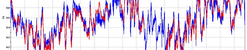
15 Normalize Average Group Hydrographs Groups 1, 2, & 4 Groups 5 & 7 Groups 3 & 6


16 Group 1 Members Potential model R 2 > 0.87


17 Group 2 Members Potential models R 2 > 0.79


18 Group 3 Members Potential models R 2 >


19 Group 4 Members Potential models R 2 > 0.48

20 Group 5 Members Potential models R 2 >

21 Group 6 Members Potential models R 2 >


22 Group 7 Members Potential models R 2 > 0.81


")
23 Anomaly Eden 3 and Upstream Broad River Proximal gaging stations have very different Proximal gaging stations have very different hydrologic behaviors (river and marsh)
24 Ranking of Stations Pearson coefficient (r) () is a measure of shared information between two stations. The lower the r values (or R 2 ), the greater the uniqueness of the station information Ranked the stations within each group Groups with more than 4 stations: re- clustered to determine first sub-group of 1
25 Ranking of Small Groups
26 Ranking of Small Groups (con t)
27 Ranking of Group 2
28 Ranking of Group 2 (con t) Remove Barron and Lopez River from correlation matrix and re-cluster

29 Ranking of Group 7


30 PCA Groupings PCA Similar to dynamic clustering groups Dynamic
31 Detecting Hydrologic Change Approach sets up a baseline of behavioral relations between station. Repeat analysis in the future to see if there are changes in the baseline. Rankings could be used in a similar way. A change in rankings could be an indication of change. Both approaches could be applied in incremental steps with long-term datasets.
32 Summary Approach used on other parameters in the network Salinity Discharge Temperature Dynamic clustering good technique for objectively group time series with similar behaviors rank time series by uniqueness of information Determine system wide behavior changes
33 The End
The Use of Synthetic Floods for Defining the Regulated Volume Duration Frequency Curves for the Red River at Fargo, ND
 The Use of Synthetic Floods for Defining the Regulated Volume Duration Frequency Curves for the Red River at Fargo, ND Prepared by the USACE - St. Paul District Hydrology & Water Management Section June
Everglades National Park
 National Park Service U.S. Department of the Interior Water Budget, Climate Variability, and Predicting Salinity for Eastern Florida Bay Erik Stabenau and Kevin Kotun National Park Service Erik_Stabenau@nps.gov
Long-Term Patterns of Coastal Response to Changing Land Use and Climate: Examples from the Atlantic and Gulf Coastal Plains
 Long-Term Patterns of Coastal Response to Changing Land Use and Climate: Examples from the Atlantic and Gulf Coastal Plains Debra Willard, Christopher Bernhardt, and Miriam Jones U.S. Geological Survey,
ESTIMATING JOINT FLOW PROBABILITIES AT STREAM CONFLUENCES USING COPULAS
 ESTIMATING JOINT FLOW PROBABILITIES AT STREAM CONFLUENCES USING COPULAS Roger T. Kilgore, P.E., D. WRE* Principal Kilgore Consulting and Management 2963 Ash Street Denver, CO 80207 303-333-1408 David B.
3.3 Classification Diagrams Estuarine Zone Coastal Lagoons References Physical Properties and Experiments in
 Contents 1 Introduction to Estuary Studies... 1 1.1 Why to Study Estuaries?.... 1 1.2 Origin and Geological Age... 4 1.3 Definition and Terminology... 7 1.4 Policy and Actions to Estuary Preservation....
Hydrography Webinar Series
 Hydrography Webinar Series Session 2 May 21, 2015 U.S. Department of the Interior U.S. Geological Survey U.S. GEOLOGICAL SURVEY HYDROGRAPHY WEBINAR SERIES Hosted by: Jeff Simley Al Rea Hydrography Webinar
Water Management and Hydrology of Northeast Shark River Slough from 1940 to 2015
 Water Management and Hydrology of Northeast Shark River Slough from 1940 to 2015 Greater Everglades Ecosystem Restoration Conference April 2015 Kevin Kotun, Hydrologist Physical Resources Branch South
An Alternative Temporal Rainfall Distribution for Hydrologic Analysis and Design
 An Alternative Temporal Rainfall Distribution for Hydrologic Analysis and Design Joseph P. Wilson, PE, PH Wilson Hydro, LLC PhD Candidate Missouri University of Science Technology Rolla, Missouri Sorry
Riverine Modeling Proof of Concept
 Technical Team Meeting Riverine Modeling Proof of Concept Version 2 HEC-RAS Open-water Flow Routing Model April 15-17, 2014 Prepared by R2 Resource Consultants, Brailey Hydrologic, Geovera, Tetra Tech,
A Comparative Study of the National Water Model Forecast to Observed Streamflow Data
 A Comparative Study of the National Water Model Forecast to Observed Streamflow Data CE394K GIS in Water Resources Term Project Report Fall 2018 Leah Huling Introduction As global temperatures increase,
Savannah Harbor Expansion Project
 Savannah Harbor Expansion Project Evaluation of Hurricane Surge Impacts with Proposed Mitigation Plan December 2007 Introduction This report summarizes the results of hurricane surge impacts with implementation
5/4/2017 Fountain Creek. Gage Analysis. Homework 6. Clifton, Cundiff, Pour, Queen, and Zey CIVE 717
 5/4/2017 Fountain Creek Gage Analysis Homework 6 Clifton, Cundiff, Pour, Queen, and Zey CIVE 717 Introduction: The CIVE 717 class members, Nate Clifton, Susan Cundiff, Ali Reza Nowrooz Pour, Robbie Queen
Estuarine Response in Northeastern Florida Bay to Major Hurricanes in 2005
 Estuarine Response in Northeastern Florida Bay to Major s in 25 By Jeff Woods and Mark Zucker s and tropical storms are critical components of the south Florida hydrologic cycle. These storms cause dramatic
Flow estimations through spillways under submerged tidal conditions
 Computational Methods and Experimental Measurements XIII 137 Flow estimations through spillways under submerged tidal conditions P. D. Scarlatos 1, M. Ansar 2 & Z. Chen 2 1 Department of Civil Engineering
Recurrence Interval for the 2006 Flood Delaware and Otsego County, New York
 Recurrence Interval for the 2006 Flood Delaware and Otsego County, New York Les Hasbargen Dept. of Earth Sciences SUNY Oneonta Ouleout Creek, flood scars Picture From : http://www.co.delaware.ny.us/flood_2006/crop%20&%20land%20photos/default.htm
ENVG/SC 10110L-20110L PLANET EARTH LABORATORY. Laboratory #9: Surface Hydrology & Map Scale
 Name: Lab day: Tuesday Wednesday ENVG/SC 10110L-20110L PLANET EARTH LABORATORY Laboratory #9: Surface Hydrology & Map Scale Readings: Chapter 9. http://www.nd.edu/~cneal/physicalgeo/lab-surfacehydrology/index.html
Big Wood River. General Information
 General Information The flows out of the southern portion of the Sawtooth National Recreation Area in central Idaho. The study reach is about a,200 ft length of river about.5 miles upstream from the discontinued
Prospects for river discharge and depth estimation through assimilation of swath altimetry into a raster-based hydraulics model
 Prospects for river discharge and depth estimation through assimilation of swath altimetry into a raster-based hydraulics model Kostas Andreadis 1, Elizabeth Clark 2, Dennis Lettenmaier 1, and Doug Alsdorf
Table (6): Annual precipitation amounts as recorded by stations X and Y. No. X Y
: Annual precipitation amounts as recorded by stations X and Y. No. X Y") Example: X and Y are two neighboring rainfall stations. Station X has complete records and station Y has some missing values. Find the linear correlation equation between the two series as mentioned in
Example: X and Y are two neighboring rainfall stations. Station X has complete records and station Y has some missing values. Find the linear correlation equation between the two series as mentioned in
Eco-hydromorphic Characterization of the Louisiana Coastal Region Using Multiple Remotely Sensed Data Sources and Analyses
 National Wetlands Research Center Eco-hydromorphic Characterization of the Louisiana Coastal Region Using Multiple Remotely Sensed Data Sources and Analyses 1Holly Beck, 2 Brady Couvillion, 1 Nadine Trahan
ENSEMBLE FLOOD INUNDATION FORECASTING: A CASE STUDY IN THE TIDAL DELAWARE RIVER
 ENSEMBLE FLOOD INUNDATION FORECASTING: A CASE STUDY IN THE TIDAL DELAWARE RIVER Michael Gomez & Alfonso Mejia Civil and Environmental Engineering Pennsylvania State University 10/12/2017 Mid-Atlantic Water
Marl Prairie vegetation response to 20th century land use and its implications for management in the Everglades
 Marl Prairie vegetation response to 20th century land use and its implications for management in the Everglades C. Bernhardt, D. Willard, B. Landacre US Geological Survey Reston, VA USA U.S. Department
St. Clair River Conveyance Change 2007 to 2012
 St. Clair River Conveyance Change 2007 to 2012 Morphologic Change in the St. Clair River 2007 2012 Conveyance Change Report U.S. Army Corps of Engineers, Detroit District Great Lakes Hydraulics and Hydrology
Squaw Creek. General Information
 General Information is a tributary to the Salmon River. It enters the north side of the river about 0 miles downstream of North Fork, Idaho. The study reach is about a 30 ft length of stream about 2 miles
Catalonia is a small region, managed by an autonomous government (depending from Spain), and placed in NE. Spain, next to Mediterranean sea.
, and placed in NE. Spain, next to Mediterranean sea.") Characterization of the river basin according to the WFD The Catalan Basins, a case of small Mediterranean water district Planning Department c/ Provença, 204-208 08036-Barcelona Introduction to Catalonia
Characterization of the river basin according to the WFD The Catalan Basins, a case of small Mediterranean water district Planning Department c/ Provença, 204-208 08036-Barcelona Introduction to Catalonia
Lower Tuolumne River Accretion (La Grange to Modesto) Estimated daily flows ( ) for the Operations Model Don Pedro Project Relicensing
 Estimated daily flows ( ) for the Operations Model Don Pedro Project Relicensing") Lower Tuolumne River Accretion (La Grange to Modesto) Estimated daily flows (1970-2010) for the Operations Model Don Pedro Project Relicensing 1.0 Objective Using available data, develop a daily time series
Lower Tuolumne River Accretion (La Grange to Modesto) Estimated daily flows (1970-2010) for the Operations Model Don Pedro Project Relicensing 1.0 Objective Using available data, develop a daily time series
Freshwater-Tidal Gradients: Eco-geomorphology Linkages to Watershed-Estuarine Dynamics
 Freshwater-Tidal Gradients: Eco-geomorphology Linkages to Watershed-Estuarine Dynamics Kathy Boomer (The Nature Conservancy) Scott Ensign (Stroud Research) Greg Noe (USGS) Concluding Speculations: It s
Mississippi River West Bay Diversion Geomorphic Assessment and 1-D Modeling Plan
 Mississippi River West Bay Diversion Geomorphic Assessment and 1-D Modeling Plan Freddie Pinkard and Charlie Little Research Hydraulic Engineers ERDC-CHL-River Engineering Branch 27 February 2009 Lane
Hydroclimatic flood trends in the northeastern United States. Matt Collins, P.H. NOAA Restoration Center
 Hydroclimatic flood trends in the northeastern United States and implications for planning and design Matt Collins, P.H. NOAA Restoration Center Gloucester, MA Lake Champlain, VT, April - May, 2011 Credit:
George Host and Tom Hollenhorst Natural Resources Research Institute University of Minnesota Duluth
 George Host and Tom Hollenhorst Natural Resources Research Institute University of Minnesota Duluth Marc Hershfield Minnesota Pollution Control Agency Duluth, MN St. Louis River watershed Duluth-Superior
An Adaptive Assessment of the Flushing Flow Needs of the Lower Poudre River, Colorado: First Evaluation
 Hydrology Days 29 An Adaptive Assessment of the Flushing Flow Needs of the Lower Poudre River, Colorado: First Evaluation 1 Robert T Milhous Hydrologist. Fort Collins, Colorado 8526 Abstract. Adaptive
9 th INTECOL Orlando, Florida June 7, 2012
 Restoration of the Everglades Saline Wetlands and Florida Bay: Responses Driven from Land and Sea David Rudnick 1, Colin Saunders 2, Carlos Coronado 2, Fred Sklar 2 Erik Stabenau 1, Vic Engel 1, Rene Price
Everglades National Park
 National Park Service U.S. Department of the Interior Climate Variability and the Coastal Physical Environment (Florida Bay) Presented by: Erik Stabenau - National Park Service Contributions from: Christina
Start of Presentation: No notes (Introductory Slide 1) 1) Salmonid Habitat Intrinsic Potential (IP) models are a type of habitat potential
 1) Salmonid Habitat Intrinsic Potential (IP) models are a type of habitat potential") The What and How of Salmonid Habitat Intrinsic Potential Modeling Start of Presentation: No notes (Introductory Slide 1) 1) Salmonid Habitat Intrinsic Potential (IP) models are a type of habitat potential
The What and How of Salmonid Habitat Intrinsic Potential Modeling Start of Presentation: No notes (Introductory Slide 1) 1) Salmonid Habitat Intrinsic Potential (IP) models are a type of habitat potential
Analysis of Tides and Storm Surge from Observational Records in the Delaware Inland Bays
 Analysis of Tides and Storm Surge from Observational Records in the Delaware Inland Bays John Callahan Delaware Geological Survey Coastal GeoTools Conference March 30 April 2, 2015 Charleston, SC Outline
Nitrate and Phosphate A Loaded Question in Illinois
 Nitrate and Phosphate A Loaded Question in Illinois Kelly Warner U.S. Geological Survey Chief of Water-Quality and Groundwater Investigations Kelly Warner (Brent Dykes, Customer Analytics for Adobe) Data
Sediment Acoustics Real-Time Continuous Suspended Sediment Data in the Lower Columbia River
 Sediment Acoustics Real-Time Continuous Suspended Sediment Data in the Lower Columbia River U.S. Department of the Interior U.S. Geological Survey Paul Diaz Jr Oregon Water Science Center Sediment Acoustics
A New National Flood Inundation Mapping Science Initiative
 A New National Flood Inundation Mapping Science Initiative William Guertal, PhD. Director, USGS Indiana and Kentucky Water Science Centers U.S. Department of the Interior U.S. Geological Survey Courtesy
Groundwater dynamics and surface water-groundwater interaction in a prograding delta island, Louisiana, USA
 Supplementary Information Groundwater dynamics and surface water-groundwater interaction in a prograding delta island, Louisiana, USA Michael T. O Connor 1* and Kevan B. Moffett 1,2 1 Department of Geological
Examination of Direct Discharge Measurement Data and Historic Daily Data for Selected Gages on the Middle Mississippi River,
 Examination of Direct Discharge Measurement Data and Historic Daily Data for Selected Gages on the Middle Mississippi River, 1861-2008 - Richard J. Huizinga, P.E. U.S. Geological Survey Missouri Water
!"#$%&&'()*+#$%(,-./0*)%(!
*+#$%(,-./0*)%(!") 8:30 Sign in Hoosic River Revival Coalition!"#$%&&'()*+#$%(,-./0*)%(! 12-#30+4/#"5-(60 9:00 Welcome and Introductions 9:15 Goals for Today s Program: A Description of the Planning Process 9:30 First Session:
8:30 Sign in Hoosic River Revival Coalition!"#$%&&'()*+#$%(,-./0*)%(! 12-#30+4/#"5-(60 9:00 Welcome and Introductions 9:15 Goals for Today s Program: A Description of the Planning Process 9:30 First Session:
May 7, Roger Leventhal, P.E. Marin County Public Works Laurel Collins Watershed Sciences
 May 7, 2013 Roger Leventhal, P.E. Marin County Public Works Laurel Collins Watershed Sciences Background Funded in 2009 under EPA 2100 Grant for $30k and managed by SFEP Project Goals: Update original
Technical Notes: Magnitude and Return Period of 2004 Hurricane Rainfall in Florida
 Journal of Floodplain Management Floodplain Management Association NOV. 2005 Vol. 5, No. 1 Glenn Tootle 1 Thomas Mirti 2 Thomas Piechota 3 Technical Notes: Magnitude and Return Period of 2004 Hurricane
Due: Monday November 26 th LAB 7: Rivers and Flood Frequency
 1 12.001 Due: Monday November 26 th LAB 7: Rivers and Flood Frequency Overview and Objectives This exercise will provide some hands-on experience with methods used for predicting flood frequency and magnitude.
Final Report V2 November 13, PREPARED BY: Tetra Tech, Inc Powers Ferry Rd. SE, Suite 202 Atlanta, Georgia Phone: (770)
") PREPARED BY: Tetra Tech, Inc. 2110 Powers Ferry Rd. SE, Suite 202 Atlanta, Georgia 30339 Phone: (770) 850-0949 Final Report V2 November 13, 2015 PREPARED FOR: Department of the Army Savannah District,
PREPARED BY: Tetra Tech, Inc. 2110 Powers Ferry Rd. SE, Suite 202 Atlanta, Georgia 30339 Phone: (770) 850-0949 Final Report V2 November 13, 2015 PREPARED FOR: Department of the Army Savannah District,
Empirical, Dimensionless, CumulativeRainfall Hyetographs Developed From Storm Data for Selected Small Watersheds in Texas
 In cooperation with the Texas Department of Transportation Empirical, Dimensionless, CumulativeRainfall Hyetographs Developed From 1959 86 Storm Data for Selected Small Watersheds in Texas Scientific Investigations
Simulating Sediment Transport in the Patapsco River following Dam Removal with Dam Removal Express Assessment Model-1 (DREAM-1)
") Simulating Sediment Transport in the Patapsco River following Dam Removal with Dam Removal Express Assessment Model-1 (DREAM-1) Prepared for Inter-Fluve 362 Atwood Ave., Suite 3 Madison, WI 53714 www.interfluve.com
Simulating Sediment Transport in the Patapsco River following Dam Removal with Dam Removal Express Assessment Model-1 (DREAM-1) Prepared for Inter-Fluve 362 Atwood Ave., Suite 3 Madison, WI 53714 www.interfluve.com
Hannah Moore CEE Juvenile Bull Trout Distribution in the South Fork Walla Walla River, Oregon
 Hannah Moore CEE 6440 Juvenile Bull Trout Distribution in the South Fork Walla Walla River, Oregon Introduction Bull trout (Salvelinus confluentus) are an endangered species historically found throughout
Typical Hydrologic Period Report (Final)
") (DELCORA) (Final) November 2015 (Updated April 2016) CSO Long-Term Control Plant Update REVISION CONTROL REV. NO. DATE ISSUED PREPARED BY DESCRIPTION OF CHANGES 1 4/26/16 Greeley and Hansen Pg. 1-3,
(DELCORA) (Final) November 2015 (Updated April 2016) CSO Long-Term Control Plant Update REVISION CONTROL REV. NO. DATE ISSUED PREPARED BY DESCRIPTION OF CHANGES 1 4/26/16 Greeley and Hansen Pg. 1-3,
Mapping the River as it Reconnects with Its Delta: Field Studies in Big Mar and Bohemia
 Mapping the River as it Reconnects with Its Delta: Field Studies in Big Mar and Bohemia Ezra Boyd, John Lopez, Andy Baker, Theryn Henkel Lake Pontchartrain Basin Foundation Coastal Sustainability Program
A New Class of Spatial Statistical Model for Data on Stream Networks: Overview and Applications
 A New Class of Spatial Statistical Model for Data on Stream Networks: Overview and Applications Jay Ver Hoef Erin Peterson Dan Isaak Spatial Statistical Models for Stream Networks Examples of Autocorrelated
Water Resources Challenges in Adams County, Pennsylvania
 Water Resources Challenges in Adams County, Pennsylvania Water Availability in the Upper Monocacy River Basin (Marsh, Rock, Alloway, and Toms Creeks) May 13, 2010 Cherie Schultz, Ph.D. Interstate Commission
Michigan s Geology and Groundwater
 Michigan s Geology and Groundwater Ralph J. Haefner Deputy Director U.S. Geological Survey Michigan-Ohio Water Science Center Lansing, Michigan Outline About the USGS Geology 101 Michigan s geology Bedrock
U.S. Department of the Interior U.S. Geological Survey. Krista Karstensen Mark Drummond
 USGS Land-Cover Trends: A focus on contemporary land-use and land-cover change within the LCCs U.S. Department of the Interior U.S. Geological Survey Krista Karstensen Mark Drummond The Challenge Land
John Callahan (Delaware Geological Survey) Kevin Brinson, Daniel Leathers, Linden Wolf (Delaware Environmental Observing System)
 Kevin Brinson, Daniel Leathers, Linden Wolf (Delaware Environmental Observing System)") John Callahan (Delaware Geological Survey) Kevin Brinson, Daniel Leathers, Linden Wolf (Delaware Environmental Observing System) Delaware is extremely vulnerable to the impacts of coastal flooding Tropical
John Callahan (Delaware Geological Survey) Kevin Brinson, Daniel Leathers, Linden Wolf (Delaware Environmental Observing System) Delaware is extremely vulnerable to the impacts of coastal flooding Tropical
A Tale of Two Storms: Surges and Sediment Deposition from Hurricanes Andrew and Wilma in Florida s Southwest Coast Mangrove Forests
 A Tale of Two Storms: Surges and Sediment Deposition from Hurricanes Andrew and Wilma in Florida s Southwest Coast Mangrove Forests By Thomas J. Smith III, Gordon H. Anderson, and Ginger Tiling Hurricanes
Modeling Hydrodynamic Effects and Salinity Intrusion. Presented by Dr. Eric Swain, USGS Water Science Center, Fort Lauderdale Florida
 Modeling Hydrodynamic Effects and Salinity Intrusion Presented by Dr. Eric Swain, USGS Water Science Center, Fort Lauderdale Florida Requirements Because coastal South Florida has unique features such
Building a European-wide hydrological model
 Building a European-wide hydrological model 2010 International SWAT Conference, Seoul - South Korea Christine Kuendig Eawag: Swiss Federal Institute of Aquatic Science and Technology Contribution to GENESIS
Each basin is surrounded & defined by a drainage divide (high point from which water flows away) Channel initiation
 Channel initiation") DRAINAGE BASINS A drainage basin or watershed is defined from a downstream point, working upstream, to include all of the hillslope & channel areas which drain to that point Each basin is surrounded &
DRAINAGE BASINS A drainage basin or watershed is defined from a downstream point, working upstream, to include all of the hillslope & channel areas which drain to that point Each basin is surrounded &
Section 4: Model Development and Application
 Section 4: Model Development and Application The hydrologic model for the Wissahickon Act 167 study was built using GIS layers of land use, hydrologic soil groups, terrain and orthophotography. Within
Nutrient and Sediment Cycling and Retention in Urban Floodplain Wetlands
 Nutrient and Sediment Cycling and Retention in Urban Floodplain Wetlands Greg Noe, Cliff Hupp, Nancy Rybicki, Ed Schenk, and Jackie Batson National Research Program, Reston VA U.S. Department of the Interior
To: Olivia Dorothy March 9, 2018 Associate Director Upper Mississippi River Basin American Rivers
 To: Olivia Dorothy March 9, 2018 Associate Director Upper Mississippi River Basin American Rivers From: Jonathan W.F. Remo Ph.D. Big Muddy Consulting Re: Assessment of flood surcharge related to differences
Using Independent NCDC Gauges to Analyze Precipitation Values from the OneRain Corporation Algorithm and the National Weather Service Procedure
 Using Independent NCDC Gauges to Analyze Precipitation Values from the OneRain Corporation Algorithm and the National Weather Service Procedure Steven M. Martinaitis iti Henry E. Fuelberg John L. Sullivan
Lake-Level Variability and Water Availability in the Great Lakes
 National Water Availability and Use Program Lake-Level Variability and Water Availability in the Great Lakes Circular 1311 U.S. Department of the Interior U.S. Geological Survey Front-cover photo: Drowned-river-mouth
Quarterly Report. 01 July 30 September 2014
 Quarterly Report Faculty of FORESTY School of AGRICULTURAL, FOREST, AND ENVIRONMENTAL SCIENCES College of AGRICULTURE, FORESTRY & LIFE SCIENCES Baruch Institute of Coastal Ecology and Forest Sciences Hwy.
Layers (Layers in italics indicate group layers.) MyHazards MyPlan* Floods and Drought Landslides - USGS
 MyHazards MyPlan* Floods and Drought Landslides - USGS") MyHazards and MyPlan WebApps for Nevada Geohazards Over 100 hazard layers related to floods, fires, earthquakes, radon, and other supporting reference layers. Powerful educational and decision-making tools
MyHazards and MyPlan WebApps for Nevada Geohazards Over 100 hazard layers related to floods, fires, earthquakes, radon, and other supporting reference layers. Powerful educational and decision-making tools
The Role of the Mangrove Ecotone Region in Regulating Nutrient Cycling and Wetland Productivity in South Florida
 The Role of the Mangrove Ecotone Region in Regulating Nutrient Cycling and Wetland Productivity in South Florida Victor H. Rivera-Monroy, Stephen E. Davis III, Robert R. Twilley, Daniel L. Childers, Marc
Development and Land Use Change in the Central Potomac River Watershed. Rebecca Posa. GIS for Water Resources, Fall 2014 University of Texas
 Development and Land Use Change in the Central Potomac River Watershed Rebecca Posa GIS for Water Resources, Fall 2014 University of Texas December 5, 2014 Table of Contents I. Introduction and Motivation..4
REDWOOD VALLEY SUBAREA
 Independent Science Review Panel Conceptual Model of Watershed Hydrology, Surface Water and Groundwater Interactions and Stream Ecology for the Russian River Watershed Appendices A-1 APPENDIX A A-2 REDWOOD
Chapter 5 CALIBRATION AND VERIFICATION
 Chapter 5 CALIBRATION AND VERIFICATION This chapter contains the calibration procedure and data used for the LSC existing conditions model. The goal of the calibration effort was to develop a hydraulic
Vermont Stream Geomorphic Assessment. Appendix J. Vermont Regional Hydraulic Geometry Curves
 Vermont Stream Geomorphic Assessment Appendix J Vermont Regional Hydraulic Geometry Curves River Management Program Vermont Water Quality Division November, 2001 Natural Resources - J0 - VT Agency of Background
Bivariate Rainfall and Runoff Analysis Using Entropy and Copula Theories
 Entropy 2012, 14, 1784-1812; doi:10.3390/e14091784 Article OPEN ACCESS entropy ISSN 1099-4300 www.mdpi.com/journal/entropy Bivariate Rainfall and Runoff Analysis Using Entropy and Copula Theories Lan Zhang
AUTOMATED ONLINE ECOLOGICAL MODELING AND EVALUATION FOR EVERGLADES MANAGEMENT AND RESTORATION
 AUTOMATED ONLINE ECOLOGICAL MODELING AND EVALUATION FOR EVERGLADES MANAGEMENT AND RESTORATION Leonard Pearlstine 1 Suresh Goldconda 2 Kevin Suir 3 Alicia LoGalbo 1 Craig Conzelmann 3 Janice Parsons 1 1
Validation of Spatially Continuous EDEN Water- Surface Model for the Everglades, Florida
 Validation of Spatially Continuous EDEN Water- Surface Model for the Everglades, Florida 2008 EDEN Report John Volin Department of Natural Resources Management and Engineering University of Connecticut
Assessing Groundwater Vulnerability and Contaminant Pathways at MCAS Beaufort, SC
 Assessing Groundwater Vulnerability and Contaminant Pathways at MCAS Beaufort, SC James M. Rine, John M. Shafer, Elzbieta Covington Abstract A project to assess the vulnerability of groundwater resources
MEETING NOTES. SOUTH CAROLINA ELECTRIC & GAS COMPANY Water Quality, Fish and Wildlife RCG Meeting. January 21, 2016
 MEETING NOTES SOUTH CAROLINA ELECTRIC & GAS COMPANY Water Quality, Fish and Wildlife RCG Meeting Final KMK 02-29-16 January 21, 2016 ATTENDEES: Bill Argentieri (SCE&G) Ray Ammarell (SCE&G) Randy Mahan
Stochastic Modeling of Extreme Floods on the American River at Folsom Dam
 US Army Corps of Engineers Hydrologic Engineering Center Stochastic Modeling of Extreme Floods on the American River at Folsom Dam Appendix E - Description of Stochastic Storm Resampling Approach and Selection
Flow regime, floodplain inundation and floodplain waterbody connectivity at Congaree National Park
 Flow regime, floodplain inundation and floodplain waterbody connectivity at Congaree National Park John Kupfer Dept. of Geography Univ. of South Carolina Kimberly Meitzen Duke University Nature Conservancy
Evaluating Physical, Chemical, and Biological Impacts from the Savannah Harbor Expansion Project Cooperative Agreement Number W912HZ
 Evaluating Physical, Chemical, and Biological Impacts from the Savannah Harbor Expansion Project Cooperative Agreement Number W912HZ-13-2-0013 First Quarterly Report January 14, 2014 Submitted by Thomas
International Symposium CLIMATE-ES March 2015 Tortosa, Tarragona, Spain
 1 2 3 4 1 (1) Museo Nacional de Ciencias Naturales, CSIC, 28006 Madrid (2) Dpt. of Geography and Earth Sciences, Aberystwyth University, UK (3) Institute of Geography, Leipzig University, 04103 Leipzig,
Application of a medium range global hydrologic probabilistic forecast scheme to the Ohio River. Basin
 Application of a medium range global hydrologic probabilistic forecast scheme to the Ohio River Basin Nathalie Voisin 1, Florian Pappenberger 2, Dennis P. Lettenmaier 1,4, Roberto Buizza 2, John C. Schaake
Modeling Processes in the South River: Discussion. South River Science Team
 Modeling Processes in the South River: Discussion South River Science Team 09-09-03 Dual Approach May Be Appropriate Fluvial Geomorphology Study landforms and changes through erosion and sedimentation
Evaluating Physical, Chemical, and Biological Impacts from the Savannah Harbor Expansion Project Cooperative Agreement Number W912HZ
 Evaluating Physical, Chemical, and Biological Impacts from the Savannah Harbor Expansion Project Cooperative Agreement Number W912HZ-13-2-0013 Second Quarterly Report - 2017 Submitted by Sergio Bernardes
USGS Hydrography Overview. May 9, 2018
 + 1 USGS Hydrography Overview May 9, 2018 + 2 The National Geospatial Program Provides the geospatial baseline of the Nation s topography, natural landscape and built environment through The National Map,
Watershed Analysis of the Blue Ridge Mountains in Northwestern Virginia
 Watershed Analysis of the Blue Ridge Mountains in Northwestern Virginia Mason Fredericks December 6, 2018 Purpose The Blue Ridge Mountain range is one of the most popular mountain ranges in the United
BSYSE 456/556 Surface Hydrologic Processes and Modeling
 BSYSE 456/556 Surface Hydrologic Processes and Modeling Lab 9 (Prepared by Erin Brooks and Jan Boll, UI, and Joan Wu, WSU) P Introduction One of the most difficult tasks in watershed assessment and management
Grant 0299-NEP: Water Resources Project Preparatory Facility
 Document Produced under Grant Project Number: 45206 May 2016 Grant 0299-NEP: Water Resources Project Preparatory Facility Final Report Volume 3 East Rapti (1 of 9) Prepared by Pvt. Ltd. For Ministry of
Connectivity Between the Mangrove Ecotone Region and Florida Bay: Current Understanding in Carbon and Nutrient Fluxes
 Connectivity Between the Mangrove Ecotone Region and Florida Bay: Current Understanding in Carbon and Nutrient Fluxes Victor H. Rivera-Monroy, Stephen E. Davis III, Robert R. Twilley, Daniel L. Childers,
Chapter 16: Correlation
 Chapter 16: Correlation Correlations: Measuring and Describing Relationships A correlation is a statistical method used to measure and describe the relationship between two variables. A relationship exists
INDIAN INSTITUTE OF SCIENCE STOCHASTIC HYDROLOGY. Lecture -27 Course Instructor : Prof. P. P. MUJUMDAR Department of Civil Engg., IISc.
 INDIAN INSTITUTE OF SCIENCE STOCHASTIC HYDROLOGY Lecture -27 Course Instructor : Prof. P. P. MUJUMDAR Department of Civil Engg., IISc. Summary of the previous lecture Frequency factors Normal distribution
Climate Downscaling 201
 Climate Downscaling 201 (with applications to Florida Precipitation) Michael E. Mann Departments of Meteorology & Geosciences; Earth & Environmental Systems Institute Penn State University USGS-FAU Precipitation
USGS National Geospatial Program Understanding User Needs. Dick Vraga National Map Liaison for Federal Agencies July 2015
 + USGS National Geospatial Program Understanding User Needs Dick Vraga National Map Liaison for Federal Agencies July 2015 + Topics 2 Background Communities of Use User Surveys National Map Liaisons Partnerships
Surface Hydrology Research Group Università degli Studi di Cagliari
 Surface Hydrology Research Group Università degli Studi di Cagliari Evaluation of Input Uncertainty in Nested Flood Forecasts: Coupling a Multifractal Precipitation Downscaling Model and a Fully-Distributed
CU Scholar. University of Colorado, Boulder. Natalie J. Gillard Spring 2016
 University of Colorado, Boulder CU Scholar Undergraduate Honors Theses Honors Program Spring 01 Changing Flood Intensities in California: Examination of Changing Annual Peak Flow Magnitudes in the Northern
ERDC/LAB TR-0X-X 100. Figure 7-3 Maximum velocity magnitudes for existing conditions for 100-year flood event
 ERDC/LAB TR-0X-X 100 Figure 7-3 Maximum velocity magnitudes for existing conditions for 100-year flood event ERDC/LAB TR-0X-X 101 Figure 7-4 Model schematization of Option 1 Figure 7-5 Bed displacement
The Virtual Estuary: What can we learn from long-term datasets and modeling efforts? Antonio Baptista OHSU-CMOP. Presented by Grant Law
 The Virtual Estuary: What can we learn from long-term datasets and modeling efforts? Antonio Baptista OHSU-CMOP Presented by Grant Law Outline 2 Introduction (5 min) The components of the virtual estuary
Application and verification of ECMWF products in Austria
 Application and verification of ECMWF products in Austria Central Institute for Meteorology and Geodynamics (ZAMG), Vienna Alexander Kann 1. Summary of major highlights Medium range weather forecasts in
IEEE GEOSCIENCE AND REMOTE SENSING LETTERS, VOL. 11, NO. 8, AUGUST
 IEEE GEOSCIENCE AND REMOTE SENSING LETTERS, VOL. 11, NO. 8, AUGUST 2014 1355 Multitemporal Multitrack Monitoring of Wetland Water Levels in the Florida Everglades Using ALOS PALSAR Data With Interferometric
RAINFALL FREQUENCY ANALYSIS FOR NEW BRAUNFELS, TX (or Seems like we ve been having lots of 100-yr storms)
") RAINFALL FREQUENCY ANALYSIS FOR NEW BRAUNFELS, TX (or Seems like we ve been having lots of 100-yr storms) Presented By: SAUL NUCCITELLI, PE, CFM (LAN) BLAKE KRONKOSKY, EIT (LAN) JIM KLEIN, PE (CITY OF
RAINFALL FREQUENCY ANALYSIS FOR NEW BRAUNFELS, TX (or Seems like we ve been having lots of 100-yr storms) Presented By: SAUL NUCCITELLI, PE, CFM (LAN) BLAKE KRONKOSKY, EIT (LAN) JIM KLEIN, PE (CITY OF
River Modeling as Big as Texas. Cédric H. David David R. Maidment, Zong-Liang Yang
 River Modeling as Big as Texas Cédric H. David David R. Maidment, Zong-Liang Yang First Water Forum Austin, TX 13 February 2012 1 Atmospheric modeling Equations of fluid mechanics and thermodynamics of