Communicating Hurricane Threats and Impacts on a National Scale. Daniel Brown Warning Coordination Meteorologist National Hurricane Center
|
|
|
- Ann Hood
- 5 years ago
- Views:
Transcription


1 Communicating Hurricane Threats and Impacts on a National Scale Daniel Brown Warning Coordination Meteorologist National Hurricane Center
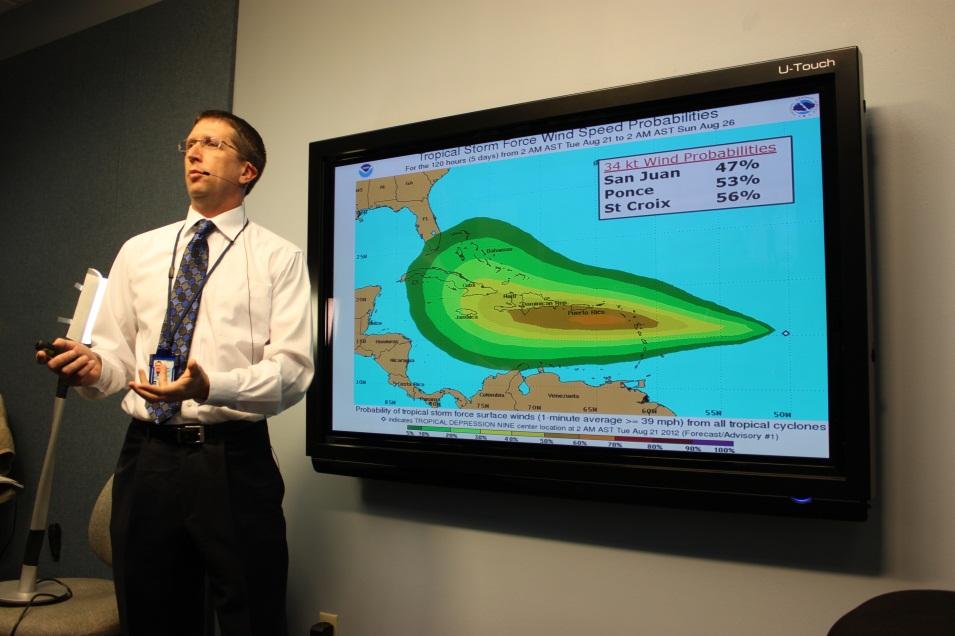
 Storm Surge Probabilities (2007) Graphical Tropical Weather Outlook")

2 New NWS Products to Help Communicate Potential Impacts New probabilistic products Wind Speed Probabilities (2005) Storm Surge Probabilities (2007) Graphical Tropical Weather Outlook introduced (2007), color-coded probabilities added (2008), and extended to 5-days (2013) Tropical Storm and Hurricane Watch & Warning lead times increased in 2010 Extreme Wind Warning Introduced (2005)

 Time of Arrival Graphic (experimental")
3 New NWS Products to Help Communicate Potential Impacts WFO Hurricane Threats and Impacts Graphics Storm Surge Flood Map became available in 2015 Storm Surge Watch/Warning introduced in 2016 (operational in 2017) Time of Arrival Graphic (experimental in 2017)

4 NWS Hurricane Irene Service Assessment Recommendations: NWS needs to improve information services and product delivery to convey relevant impacts, risks, and the urgency of required actions associated with landfalling tropical cyclones for use by decision makers without meteorological expertise. Through programs such as the FEMA Hurricane Liaison Team at NHC, NOAA/NWS should actively recruit new and develop existing NOAA/NWS scientists who can effectively communicate with those at the highest levels of government.


5 NWS Hurricane Sandy Service Assessment Best Practices: Development and delivery of concise DSS briefings and briefing packages, including one-pagers and presentations that synthesized complex information. Briefings contained graphic and textbased information, focused on impacts, and contained confidence and worstcase scenario information that aided decision making.
6 Weather Information Available Briefing Content Decisions that need to be Made
7 What are customer needs, and how do they differ? Emergency manager Increased level of spatial and temporal detail Increased level of uncertainty communicated Media (Radio vs. Television vs. Newspaper) Less spatial and temporal detail More protective action discussion/recommendation (general) Less uncertainty communicated Likely your briefing (interview) will be edited before release
8 Briefing Structure Start and finish with important points Briefing Content Focus on the what, and not the why Briefing Clarity (performance) Speak customer s language
9 All briefings should be designed to answer these questions: What is it When is it going to get here What is it going to do When is it going to be over What is your confidence this will occur

10 Must Know Introduction 3-5 Points Must Remember Support Material The what, where, and when Confidence Summarize Must Know Restate must know points Focus questions Always begin and end with what you want remembered
 Signal to noise ratio Complexity vs. Simplicity Detail vs.")
11 Language (text, words) Graphs, Plots, Maps Symbols Colors Graphics (photos, schematics, etc) Signal to noise ratio Complexity vs. Simplicity Detail vs. Brevity
12 You will have more information than you can, or should, brief. Prioritize information. State what they need to know, no more. Focus on the what, not the why. Tailored for targeted customer base. Water managers vs. EM/civil defense
13 Explain what it is Ordinate, abscissa, plot, symbols Briefly describe region Point out a frame of reference Reduce Noise If not discussed, don t include
14

15 The What, Not the Why!
16 Do not bury the lead Be nice and concise Sell what you have to say Be confident, calm, and assertive Speak like the audience is taking notes Anticipate questions and responses If you don t have anything to say, don t say it
17 Tell me what I need to know, when I need to know it Skip Dugger, FDEM retired

18 Assist people in making more effective decisions Helps manage user expectations Promotes user confidence Probabilistic forecasts allows user to set thresholds Reflects the state of the science Words matter - chose them carefully!


19 Katrina Higher Storm Surge from Isaac in parts of SE Louisiana due to angle of approach and different landfall location Isaac Every storm is different (size, intensity, structure, angle of approach). Analogs can be carefully used to explain with this storm is going to be different than a past one.
20 Not by outlining why you could be wrong But by giving a range of possibilities Here is our best estimate / what we do know Here is what you should be planning for-- reasonable worst case/alternate scenarios
21 "The NWS forecast is just that - a forecast. And we need to be prepared to respond to incidents based on the best available information. The most important aspect of this event is that people responded and lives were saved." - Craig Fugate


22 Hurricane Liaison Team Providing real-time support Initial idea arose in the early 1990 s Proven during response to the 1995 Hurricane Season Andy Newman Former National Hurricane Center Director Max Mayfield discusses where to issue watches and warnings along the west coast of Florida for Hurricane Charley. Formalized in 1996 Request from Governor of Florida to FEMA and NHC Director

23 Hurrevac: Hurricane Liaison Team Augment rapid communications Timing of hazards vs Clearance times Partnership between the NWS and FEMA FEMA Hurricane Program Managers FEMA Reservists NWS meteorologists and hydrologists Support response operations through the rapid exchange of critical information between the National Hurricane Center and emergency managers at all levels.
 Responding to emergency management questions and concerns.")
24 Hurrevac: Hurricane Liaison Team Augment rapid communications Timing of hazards vs Clearance times Video/Teleconferences NHC/NWS FEMA and other Federal Agencies State Emergency Operations Centers (EOCs) Responding to emergency management questions and concerns. 24


25 Communicating the Forecast with State and Federal emergency management
Coordinated Safety Messaging: An Integrated Approach. Matt Moreland FLGHC: Effective Messaging and Decision Support Services May 16, 2017
 Coordinated Safety Messaging: An Integrated Approach Matt Moreland FLGHC: Effective Messaging and Decision Support Services May 16, 2017 Question According to most meteorologists, how long should a weather
The Wind Hazard: Messaging the Wind Threat & Corresponding Potential Impacts
 The Wind Hazard: Messaging the Wind Threat & Corresponding Potential Impacts Scott Spratt Warning Coordination Meteorologist NWS Melbourne, FL David Sharp Science & Operations Officer NWS Melbourne, FL
RSMC-Miami Update Daniel Brown Warning Coordination Meteorologist
 RSMC-Miami Update 2016 Daniel Brown Warning Coordination Meteorologist L-0324 Emergency Management Hurricane Preparedness Training Course Funding provided by FEMA s National Hurricane Program - partnership
National Hurricane Program. FEMA Region IV
 National Hurricane Program FEMA Region IV Percent NHP A quick background Hurricane Program major buckets (Toolboxes) Hurricane Evacuation Study HURREVAC Post Storm Assessments Training Hurricane Liaison
WELCOME TO THE 2018 RA-IV WORKSHOP ON HURRICANE FORECASTING AND WARNING
 WELCOME TO THE 2018 RA-IV WORKSHOP ON HURRICANE FORECASTING AND WARNING Richard J. Pasch and Daniel P. Brown Senior Hurricane Specialists National Hurricane Center ORIENTATION Use of PCs NHC Facility Workshop
The Local Wind Forecast and Its Uncertainty (Completing the Wind Forecast)
") The Local Wind Forecast and Its Uncertainty (Completing the Wind Forecast) Florida Governor Hurricane Conference May 11-16 2014 Pablo Santos Meteorologist In Charge NWS Miami/South Florida Forecast Office
The Local Wind Forecast and Its Uncertainty (Completing the Wind Forecast) Florida Governor Hurricane Conference May 11-16 2014 Pablo Santos Meteorologist In Charge NWS Miami/South Florida Forecast Office
Hurricane Readiness for Coastal Communities
 Hurricane Readiness for Participant Guide Developed for: Federal Emergency Management Agency Emergency Management Institute 16825 South Seton Avenue Emmitsburg, MD 21727-8998 Developed by: C² Technologies,
NWS Flood Warning Products plus a Look Ahead
 NWS Flood Warning Products plus a Look Ahead September 21 & 22, 2010 DRBC Flood Warning Users Forum Presented by Gary Szatkowski Meteorologist-in-Charge NOAA s National Weather Service Philadelphia/Mt.
NOAA s National Weather Service. National Weather Service
 NOAA s National Weather Service Serving the Nation s Environmental Forecasting Needs Lynn Maximuk Regional Director National Weather Service Central Region Headquarters Kansas City, Missouri America s
Planning for the Threat Preparing for the Impacts The Role of the Local Forecast
 Planning for the Threat Preparing for the Impacts The Role of the Local Forecast 2014 Florida Governor Hurricane Conference Pablo Santos NOAA/NWS WFO Miami, FL 2014 - FLGHC 2014 - FLGHC Decision Support
Probabilistic Hurricane Storm Surge A Local Perspective
 Probabilistic Hurricane Storm Surge A Local Perspective Florida Governor Hurricane Conference May 11-16 2014 2014 FLGHC TS 22 Pablo Santos Meteorologist In Charge NWS Miami/South Florida Forecast Office
Canadian Hurricane Center: How NHC Products are used to issue Warnings and Communicate Hazards
 Canadian Hurricane Center: How NHC Products are used to issue Warnings and Communicate Hazards Bob Robichaud Warning Preparedness Meteorologist Canadian Hurricane Centre Contents Brief background on the
National Weather Service
 National Weather Service Performance and Challenges Warning Systems Kenneth E. Graham Meteorologist-in-Charge New Orleans Busy 2008 Number of Tornadoes Number of Tornado Fatalities *Preliminary So Far
Hurricane Shelter Standards Governors Hurricane Conference 2018
 Hurricane Shelter Standards Governors Hurricane Conference 2018 Partnership with Florida Local Level State Level Hurricane Evacuation Studies Hurricane Evacuation Study Fresh Water Flooding Storm Surge
Frank Revitte National Weather Service. Weather Forecast Office New Orleans/Baton Rouge
 Frank Revitte National Weather Service Weather Forecast Office New Orleans/Baton Rouge Above normal activity 17 Total Named Storms 7 Tropical Storms 4 Hurricanes 6 Major Hurricanes Not the most active,
United States Multi-Hazard Early Warning System
 United States Multi-Hazard Early Warning System Saving Lives Through Partnership Lynn Maximuk National Weather Service Director, Central Region Kansas City, Missouri America s s Weather Enterprise: Protecting
Donna J. Kain, PhD and Catherine F. Smith, PhD East Carolina University
 Risk Perceptions and Emergency Communication Effectiveness in Coastal Zones Preliminary Findings on Interpretations of Weather Related Messages and Maps Donna J. Kain, PhD (kaind@ecu.edu), and Catherine
VISIT MISSISSIPPI GULF COAST CRISIS COMMUNICATION MANUAL 2016
 VISIT MISSISSIPPI GULF COAST CRISIS COMMUNICATION MANUAL 2016 This manual was prepared for Visit Mississippi Gulf Coast staff in the event of a crisis, and will help to distinguish the appropriate course
Scenario-based Language for Hurricane Decision Support
 Scenario-based Language for Hurricane Decision Support David Sharp NOAA/National Weather Service Melbourne, FL Pablo Santos NOAA/National Weather Service Miami, FL Weather Model Outcomes (as seen on TV)
HVX-HURREVAC (Beta) Webinar Series
 Webinar Series") HVX-HURREVAC (Beta) Webinar Series Day 1 - An introduction to HURREVAC and the new web-based HVX platform 2018 HVX-HURREVAC Webinar Series 1. Intro to HURREVAC and General Overview of the Program (August
HVX-HURREVAC (Beta) Webinar Series Day 1 - An introduction to HURREVAC and the new web-based HVX platform 2018 HVX-HURREVAC Webinar Series 1. Intro to HURREVAC and General Overview of the Program (August
The Nuts and Bolts of These Community Preparedness Recognition Programs
 The Nuts and Bolts of These Community Preparedness Recognition Programs Bill Sammler Warning Coordination Meteorologist NOAA s National Weather Service, Wakefield VA http://weather.gov/akq Why is StormReady
An Overview of Operations at the West Gulf River Forecast Center Gregory Waller Service Coordination Hydrologist NWS - West Gulf River Forecast Center
 National Weather Service West Gulf River Forecast Center An Overview of Operations at the West Gulf River Forecast Center Gregory Waller Service Coordination Hydrologist NWS - West Gulf River Forecast
A Look Back at the 2012 Hurricane Season and a Look Ahead to 2013 & Beyond. Daniel Brown National Hurricane Center Miami, Florida 24 April 2013
 A Look Back at the 2012 Hurricane Season and a Look Ahead to 2013 & Beyond Daniel Brown National Hurricane Center Miami, Florida 24 April 2013 2012 Atlantic Verification Good News- Lots of Accuracy Records
2017 Hurricane Season and Beyond
 2017 Hurricane Season and Beyond Ken Graham National Hurricane Center Building a Weather-Ready Nation Much of U.S. Coast Saw Tropical Wind Watches or Warnings 2017 Hurricane Season Facts and Figures 7th
Communications and Lessons Learned from
 Weather Forecast Office Charleston, SC Communications and Lessons Learned from Southeast and Caribbean and Climate Community of Practice - April, 2017 Public Information and Communications During Extremes
HURREVAC Webinar Series Day 1 Intro to HURREVAC and General Overview of the Program. National Hurricane Program Training Course
 HURREVAC Webinar Series Day 1 Intro to HURREVAC and General Overview of the Program 2017 HURREVAC Webinar Series 1. Intro to HURREVAC and General Overview of the Program (August 7 th or 14 th ) 2. Evacuation
Wind Speed Probability Products. Daniel Brown and Michael Brennan National Hurricane Center
 Wind Speed Probability Products Daniel Brown and Michael Brennan National Hurricane Center 2017 WMO Course 7 March 2017 Wind Speed Probabilities A Tool to Deal with Uncertainty Hurricane Irene Advisory
Wind Speed Probability Products
 Wind Speed Probability Products Daniel Brown National Hurricane Center 2018 WMO Course 6 March 2018 Wind Speed Probabilities A Tool to Deal with Uncertainty Hurricane Irene Advisory Number 12 Issued 5:00
Unit 5: NWS Hazardous Weather Products. Hazardous Weather and Flooding Preparedness
 Unit 5: NWS Hazardous Weather Products Objectives Describe the mission of the NWS Describe the basic organizational structure of the NWS Explain the purpose of various NWS products Explain how Probability
Outlook 2008 Atlantic Hurricane Season. Kevin Lipton, Ingrid Amberger National Weather Service Albany, New York
 Outlook 2008 Atlantic Hurricane Season Kevin Lipton, Ingrid Amberger National Weather Service Albany, New York Summary 2007 Hurricane Season Two hurricanes made landfall in the Atlantic Basin at category-5
TXWARN Tabletop Exercise: Hurricane Helen
 TXWARN Tabletop Exercise: Hurricane Helen July 31, 2015 Administrative Details In-studio participants and remote participants Situation manual Evaluations Training hours 1 In Studio: Welcome and Introductions
Department of Industrial and Manufacturing Systems Engineering. The Online Hurricane Decision Simulator
 Department of The Online Hurricane Decision Simulator Cameron MacKenzie Assistant Professor Iowa State University Eva Regnier Associate Professor Naval Postgraduate 1 U.S. Marine Forces Reserve (MFR) Lt.
Major Hurricane Matthew Briefing Situation Overview
 Major Hurricane Matthew Briefing Situation Overview THIS IS NOW A WORST CASE STORM SURGE SCENARIO Catastrophic Damage is Anticipated for Coastal Areas. Major Hurricane Matthew is still expected to move
CERA-Atlantic Storm Surge Web Page: Improvements for 2013 Based on EM Feedback
 CERA-Atlantic Storm Surge Web Page: Improvements for 2013 Based on EM Feedback Jessica Losego Meteorologist University of North Carolina - Institute for the Environment Rick Luettich Director, UNC IMS
Daily Operations Briefing. Friday, October 6, :30 a.m. EDT
 Daily Operations Briefing Friday, October 6, 2017 8:30 a.m. EDT Significant Activity Oct 5-6 Significant Events: Response for Hurricane Maria, Preparations for Tropical Storm Nate Tropical Activity: Atlantic
A HURRICANE IS COMING. Presented by Atiba Upchurch Broward Emergency Management Division
 A HURRICANE IS COMING Presented by Atiba Upchurch Broward Emergency Management Division Mission Statement To safeguard the lives and property of the people of Broward County from major hazards and emergencies
Building a Weather Ready Nation: Linking Impact Based Decision Support Services to Observations, Forecasts, Warnings & Dissemination
 Building a Weather Ready Nation: Linking Impact Based Decision Support Services to Observations, Forecasts, Warnings & Dissemination Dr. Louis W. Uccellini Director, NOAA Assistant Administrator for Weather
TROPICAL STORM NATE BRIEFING
 TROPICAL STORM NATE BRIEFING 10:30 AM CDT Friday, October 06, 2017 Prepared by: NWS NWSNewOrleans www.weather.gov/neworleans Situation Overview Track forecast has shifted slightly eastward. Hurricane Watch
Smart Flood Risk Management Solutions
 Smart Flood Risk Management Solutions - RHDHV s Experience in the Gulf of Mexico Mathijs van Ledden, Marten Hillen and Ries Kluskens Challenge Extreme weather around the world (hurricanes, cyclones, extratropical
NWS HURRICANES June 3, 2015
 NWS HURRICANES June 3, 2015 Hurricane Season June 1 November 30 2 What s the concern? All tropical systems passing within 125nm of central Maryland since 1950 Mid-Atlantic Hurricanes Greatest Risk: August
TROPICAL CYCLONE TORNADOES
 TROPICAL CYCLONE TORNADOES 2018 GOVERNOR S HURRICANE CONFERENCE TUESDAY, MAY 15, 2018 WILL ULRICH NWS FORECAST OFFICE MELBOURNE WHERE ARE THE TORNADOES? WHERE ARE THE TORNADOES? C B A WEST MELBOURNE, FL
Arkansas-Red Basin River Forecast Center Operations. RRVA Conference Durant, OK 8/22/2013 Jeff McMurphy Sr. Hydrologist - ABRFC
 Arkansas-Red Basin River Forecast Center Operations RRVA Conference Durant, OK 8/22/2013 Jeff McMurphy Sr. Hydrologist - ABRFC NWS River Forecast Centers NWS Weather Forecast Offices Operations Staffing
Communicating uncertainty from short-term to seasonal forecasting
 Communicating uncertainty from short-term to seasonal forecasting MAYBE NO YES Jay Trobec KELO-TV Sioux Falls, South Dakota USA TV weather in the US Most TV weather presenters have university degrees and
Enhancing Weather Information with Probability Forecasts. An Information Statement of the American Meteorological Society
 Enhancing Weather Information with Probability Forecasts An Information Statement of the American Meteorological Society (Adopted by AMS Council on 12 May 2008) Bull. Amer. Meteor. Soc., 89 Summary This
TROPICAL STORM NATE BRIEFING
 TROPICAL STORM NATE BRIEFING 5:00 AM CDT Friday, October 6, 2017 Prepared by: NWS NWSNewOrleans www.weather.gov/neworleans Situation Overview No significant changes to the track forecast this morning.
EFFECTIVE WARNING PROCESS: RECENT SOCIAL SCIENCE CONTRIBUTIONS
 EFFECTIVE WARNING PROCESS: RECENT SOCIAL SCIENCE CONTRIBUTIONS International Workshop on Tropical Cyclones 04 December 2014 Republic of Korea Dr. Betty Morrow, SocResearch Miami Dr. Jeffrey Lazo, National
HURRICANE Information for the Teacher
 HURRICANE Information for the Teacher This hurricane simulation activity and STELLA model were adapted from materials developed by Jan Mons and Cathy Eaton of the Glynns Integration of Systems Thinking
Tropical Update. 11 AM EDT Tuesday, October 9, 2018 Hurricane Michael, Tropical Storm Leslie, Tropical Storm Nadine
 Tropical Update 11 AM EDT Tuesday, October 9, 2018 Hurricane Michael, Tropical Storm Leslie, Tropical Storm Nadine This update is intended for government and emergency response officials, and is provided
TROPICAL STORM NATE BRIEFING
 TROPICAL STORM NATE BRIEFING 2:00 PM CDT Friday, October 06, 2017 Prepared by: NWS NWSNewOrleans www.weather.gov/neworleans Situation Overview Track forecast has not changed since the 10 am advisory. Hurricane
Developing Products with Partners
 Developing Products with Partners Hydro-Climatology Products Integrated Water Resources Science & Service Community Hydrologic Prediction System Water Resources Outlook Precipitation Frequency Estimates
Miami-Dade County Overview
 Miami-Dade County Overview 2,000 square miles World s busiest cruise port 2.6 million residents Second busiest US airport for international travelers Gateway to the Caribbean and Latin America Natural
Dr. Steven Koch Director, NOAA National Severe Storms Laboratory Chair, WRN Workshop Executive Committee. Photo Credit: Associated Press
 Dr. Steven Koch Director, NOAA National Severe Storms Laboratory Chair, WRN Workshop Executive Committee 1 Photo Credit: Associated Press 1" 2" Much%Increased%Vulnerability%to% High6Impact%Weather% %even%before%2011!%
What s s New for 2009
 What s s New for 2009 Graphical Tropical Weather Outlook becomes operational Special Tropical Disturbance Statement replaced with Special Tropical Weather Outlook Tropical Cyclone Wind Field Graphic becomes
GC Briefing. Weather Sentinel Tropical Storm Michael. Status at 8 AM EDT (12 UTC) Today (NHC) Discussion. October 11, 2018
 Today (NHC) Discussion. October 11, 2018") GC Briefing Weather Sentinel Tropical Storm Michael October 11, 2018 After making landfall as a high-end category-4 hurricane on the Florida Panhandle, Michael weakened to tropical storm status early this
GC Briefing Weather Sentinel Tropical Storm Michael October 11, 2018 After making landfall as a high-end category-4 hurricane on the Florida Panhandle, Michael weakened to tropical storm status early this
The Weather Information Value Chain
 The Weather Information Value Chain Jeffrey K. Lazo Societal Impacts Program National Center for Atmospheric Research Boulder CO April 27 2016 HIWeather Exeter, England Outline Shout out on WMO/USAID/World
HURREVAC REFERENCE IMPORTANT INFORMATION TO KNOW WHEN A STORM IS APPROACHING
 HURREVAC REFERENCE IMPORTANT INFORMATION TO KNOW WHEN A STORM IS APPROACHING PART 1: Workspace Layout Program Header (1 Red) Includes tools that allow the user to manage program setup, update forecast
Maximizing the effectiveness and socio-economic benefits of weather products and services the Hong Kong Experience
 Maximizing the effectiveness and socio-economic benefits of weather products and services the Hong Kong Experience Queenie C.C. Lam Scientific Officer Hong Kong Observatory Hong Kong, China Meeting of
2015 Hurricane Season Outlook and Preparedness. Amy Godsey State Meteorologist State Emergency Response Team Florida Division of Emergency Management
 2015 Hurricane Season Outlook and Preparedness Amy Godsey State Meteorologist State Emergency Response Team Florida Division of Emergency Management 2015 Hurricane Season Last Hurricane Landfall: Kate
Tropical Update. 5 PM EDT Thursday, September 7, 2017 Hurricane Irma, Hurricane Jose, and Hurricane Katia
 Tropical Update 5 PM EDT Thursday, September 7, 2017 Hurricane Irma, Hurricane Jose, and Hurricane Katia This update is intended for government and emergency response officials, and is provided for informational
13.2 USING VIRTUAL GLOBES TO IMPROVE SITUATIONAL AWARENESS IN THE NATIONAL WEATHER SERVICE
 13.2 USING VIRTUAL GLOBES TO IMPROVE SITUATIONAL AWARENESS IN THE NATIONAL WEATHER SERVICE Andy Foster* National Weather Service Springfield, Missouri* Keith Stellman National Weather Service Shreveport,
Rainfall-River Forecasting: Overview of NOAA s Role, Responsibilities, and Services
 Dr. Thomas Graziano Chief Hydrologic Services Division NWS Headquarters Steve Buan Service Coordination Hydrologist NWS North Central River Forecast Center Rainfall-River Forecasting: Overview of NOAA
NWS Resources For School Districts
 NWS Resources For School Districts January 23rd, 2017 Shawn DeVinny shawn.devinny@noaa.gov Meteorologist National Weather Service Twin Cities/Chanhassen, MN Outline Watches/Warnings/Advisories Example
National Hurricane Center Products. Jack Beven National Hurricane Center
 National Hurricane Center Products Jack Beven National Hurricane Center Florida Governor s Hurricane Conference 11 May 2014 NHC Tropical Cyclone Products NHC provides the big picture that complements and
CLIMATE SERVICES for the AGRICUTURAL SECTOR in the PHILIPPINES
 CLIMATE SERVICES for the AGRICUTURAL SECTOR in the PHILIPPINES EDNA L. JUANILLO Weather Services Chief, PAGASA Technical Conference on Future Challenges and Opportunities in Agricultural Meteorology 16-17
The Historic South Carolina Floods of October 1-5, NWS Service Assessment. Denna Geppi, Ph.D., Social Scientist PRSS/CFO.
 The Historic South Carolina Floods of October 1-5, 2015- NWS Service Assessment Denna Geppi, Ph.D., Social Scientist PRSS/CFO April 2017 MISSION Provide strategic, financial, and operational leadership
Improving global coastal inundation forecasting WMO Panel, UR2014, London, 2 July 2014
 Improving global coastal inundation forecasting WMO Panel, UR2014, London, 2 July 2014 Cyclone Sidr, November 2007 Hurricane Katrina, 2005 Prof. Kevin Horsburgh Head of marine physics, UK National Oceanography
Storm Surge/Coastal Inundation State of the Union. Jamie Rhome Storm Surge Team Lead NOAA/National Hurricane Center
 Storm Surge/Coastal Inundation State of the Union Jamie Rhome Storm Surge Team Lead NOAA/National Hurricane Center 2 Tampa: Cat 5 Scenario 3 4 The Stakes are High Combination of SLR and increasing coastal
Tropical Update. 5 AM EDT Thursday, September 7, 2017 Hurricane Irma, Hurricane Jose, and Hurricane Katia
 Tropical Update 5 AM EDT Thursday, September 7, 2017 Hurricane Irma, Hurricane Jose, and Hurricane Katia This update is intended for government and emergency response officials, and is provided for informational
Building a Weather-Ready Nation For Aviation
 Building a Weather-Ready Nation For Aviation Laura Furgione NOAA Deputy Assistant Administrator for Weather Services Friends and Partners in Aviation Weather July 22, 2014 Case for Change Average Year
Overview of the Tropical Cyclone Guidance Project
 Overview of the Tropical Cyclone Guidance Project Dr. Jonathan L. Vigh With thanks to Mahsa Mirzargar (Univ. of Miami) Shanghai Typhoon Institute 09 July 2018 NCAR is sponsored by the National Science
Weather Analysis and Forecasting
 Weather Analysis and Forecasting An Information Statement of the American Meteorological Society (Adopted by AMS Council on 25 March 2015) Bull. Amer. Meteor. Soc., 88 This Information Statement describes
National Situation Report As of 3:00 a.m. EDT, Thursday, September 21, 2017 Table of Contents Current Operations Monitoring Recovery
 25k Overview National Situation Report As of 3:00 a.m. EDT, Thursday, September 21, 2017 Table of Contents Current Operations Monitoring Recovery FEMA Headquarters Status FEMA Region Status NRCC Level
EVALUATION AND VERIFICATION OF PUBLIC WEATHER SERVICES. Pablo Santos Meteorologist In Charge National Weather Service Miami, FL
 EVALUATION AND VERIFICATION OF PUBLIC WEATHER SERVICES Pablo Santos Meteorologist In Charge National Weather Service Miami, FL WHAT IS THE MAIN DIFFERENCE BETWEEN A GOVERNMENT WEATHER SERVICE FORECAST
Tropical Update. 5 PM EDT Sunday, October 7, 2018 Tropical Storm Michael, Tropical Storm Leslie, & Invest 92L (30%)
") Tropical Update 5 PM EDT Sunday, October 7, 2018 Tropical Storm Michael, Tropical Storm Leslie, & Invest 92L (30%) This update is intended for government and emergency response officials, and is provided
Tropical Update 5 PM EDT Sunday, October 7, 2018 Tropical Storm Michael, Tropical Storm Leslie, & Invest 92L (30%) This update is intended for government and emergency response officials, and is provided
We Had No Warning An Overview of Available Forecast Products Before and During Severe Weather Events
 We Had No Warning An Overview of Available Forecast Products Before and During Severe Weather Events Two main sources for severe weather info NOAA/NWS Storm Prediction Center (SPC) Convective Outlooks
Coastal Inundation Forecasting Demonstration Project CIFDP. Flood Forecasting Initiative-Advisory Group (FFI-AG 3), Geneva, 5-7 Dec, 2017
, Geneva, 5-7 Dec, 2017") Coastal Inundation Forecasting Demonstration Project CIFDP Flood Forecasting Initiative-Advisory Group (FFI-AG 3), Geneva, 5-7 Dec, 2017 Coastal Flooding & Vulnerable Populations Coastal populations are
Coastal Inundation Forecasting Demonstration Project CIFDP Flood Forecasting Initiative-Advisory Group (FFI-AG 3), Geneva, 5-7 Dec, 2017 Coastal Flooding & Vulnerable Populations Coastal populations are
2006 & 2007 Pre-Hurricane Scenario Analyses
 2006 & 2007 Pre-Hurricane Scenario Analyses Executive Summary May 2007 Page 1 OF X FOR OFFICIAL USE ONLY 4 Public Availability to be Determined Under 5 U.S.C. 552 NOTE: Limited Distribution. Release of
Tropical Update. 5 AM EDT Tuesday, September 12, 2017 Post-Tropical Cyclone Irma, Hurricane Jose, & Tropical Wave (10%)
") Tropical Update 5 AM EDT Tuesday, September 12, 2017 Post-Tropical Cyclone Irma, Hurricane Jose, & Tropical Wave (10%) This update is intended for government and emergency response officials, and is provided
Tropical Update 5 AM EDT Tuesday, September 12, 2017 Post-Tropical Cyclone Irma, Hurricane Jose, & Tropical Wave (10%) This update is intended for government and emergency response officials, and is provided
The NOAA/NWS Warning Decision Training Branch (WDTB): On-line Training Resources for Emergency Managers & Intro to Dual-Polarization Radar
: On-line Training Resources for Emergency Managers & Intro to Dual-Polarization Radar") The NOAA/NWS Warning Decision Training Branch (WDTB): On-line Training Resources for Emergency Managers & Intro to Dual-Polarization Radar Andy Wood CIMMS (University of Oklahoma)/ WDTB (NOAA/NWS) The
The NOAA/NWS Warning Decision Training Branch (WDTB): On-line Training Resources for Emergency Managers & Intro to Dual-Polarization Radar Andy Wood CIMMS (University of Oklahoma)/ WDTB (NOAA/NWS) The
Case Studies in Communication Challenges: Hurricane Sandy
 Case Studies in Communication Challenges: Hurricane Sandy International Workshop on Tropical Cyclones Jeju Island, South Korea Chris Landsea, National Hurricane Center, RSMC Miami Major Hurricane Sandy
Betty Hearn Morrow Consulting Sociologist Professor Emerita, Florida International University
 Betty Hearn Morrow Consulting Sociologist Professor Emerita, Florida International University 2018 WMO RA-IV Workshop on Hurricane Forecasting and Warning National Hurricane Center - Miami, Florida 8 March
Common Core Reading Passage
 Directions: Please read the following Common Core Reading passage and answer the questions that follow. Common Core Reading Passage Forecasting Severe Weather to Communities Helps Them Prepare By Alissa
City of Punta Gorda Community Emergency Management Plan 2013
 City of Punta Gorda Community Emergency Management Plan 2013 Hurricane Andrew- August 24, 1992 Category 5 hurricane. The second-most-destructive hurricane in U.S. history. The first named storm of the
Tropical Update. 5 PM EDT Sunday, September 10, 2017 Hurricane Irma, Hurricane Jose, Tropical Wave (60%)
") Tropical Update 5 PM EDT Sunday, September 10, 2017 Hurricane Irma, Hurricane Jose, Tropical Wave (60%) This update is intended for government and emergency response officials, and is provided for informational
Tropical Update 5 PM EDT Sunday, September 10, 2017 Hurricane Irma, Hurricane Jose, Tropical Wave (60%) This update is intended for government and emergency response officials, and is provided for informational
By: Jill F. Hasling, Certified Consulting. Houston, Texas. November 2016
 Thirty-three Years of Annual Atlantic Hurricane Season Outlooks Comparison of Weather Research Center Cyclone Strike Index with Colorado State s Hurricane Outlook By: Jill F. Hasling, Certified Consulting
WMO Public Weather Services: Enhanced Communication Skills for Improved Service Delivery. by S.W. Muchemi (WMO)
") WMO Public Weather Services: Enhanced Communication Skills for Improved Service Delivery by S.W. Muchemi (WMO) Functions of the Public Weather Services (PWS) programme of WMO To strengthen the capabilities
WMO Public Weather Services: Enhanced Communication Skills for Improved Service Delivery by S.W. Muchemi (WMO) Functions of the Public Weather Services (PWS) programme of WMO To strengthen the capabilities
Complete Weather Intelligence for Public Safety from DTN
 Complete Weather Intelligence for Public Safety from DTN September 2017 White Paper www.dtn.com / 1.800.610.0777 From flooding to tornados to severe winter storms, the threats to public safety from weather-related
Canes on Canes: Keeping South Florida Prepared During the Calm Before the Storm. Matt Onderlinde and Pete Finocchio
 Canes on Canes: Keeping South Florida Prepared During the Calm Before the Storm Matt Onderlinde and Pete Finocchio Outline The Science of Hurricanes Why and When South Floridians Must Be Weather-Ready
Cómo contar la predicción probabilistica? Part II: From body language to percentages
 Cómo contar la predicción probabilistica? How to tell probabilities in weather forecasting? Part II: From body language to percentages 1 From 100% qualitative to 100% quantitative probability communication
2008 Hurricane Caravan. Daniel Noah Meteorologist National Weather Service x1 May 22, 2008
 2008 Hurricane Caravan Daniel Noah Meteorologist National Weather Service daniel.noah@noaa.gov, 813-645-2323 x1 May 22, 2008 National Weather Service We never close! Open 24 hours a day 365 days per year
Flood Risk Mapping and Forecasting in England
 Flood Risk Mapping and Forecasting in England Mark Franklin Environment Agency, England NORDESS Workshop on Risk Assessment and Acceptable Risk Outline Flood risk in England Who we are and how we work
HURRICANE MATTHEW A GIS PERSPECTIVE GLYNN COUNTY GIS
 HURRICANE MATTHEW A GIS PERSPECTIVE GLYNN COUNTY GIS Situation September 25 th October 9 th 2016 Hurricane Matthew tracked its way up the east coast bringing hurricane force winds and flooding from Haiti
HURREVAC The software Tool used by emergency officials for hurricane evacuation assistance
 HURREVAC 2010 A Quick Reference enc e Guide The software Tool used by emergency officials for hurricane evacuation assistance www.hurrevac.com FinalHURREVAC2010Guide.indd 1 About HURREVAC HURREVAC is a
Situation Manual Protective Actions
 Situation Manual Protective Actions 175 Minutes Situation Manual Tabletop Exercise 1 Disaster Resistant Communities Group www.drc-group.com Tallahassee Twister Start Exercise No Image During the exercise
Graphics Improvement
 Meteorological Model Ensemble Forecast System (MMEFS) (0 7 Day Potential River Levels) Graphics Improvement Robert Shedd Service Coordination Hydrologist NOAA/NWS Middle Atlantic River Forecast Center
Weather forecasts and warnings: Support for Impact based decision making
 Weather forecasts and warnings: Support for Impact based decision making Gerry Murphy, Met Éireann www.met.ie An Era of Change Climate and weather is changing Societal vulnerability is increasing The nature
Importance of Technology as part of the NWS New Orleans/Baton Rouge Impact- Based Decision Support Pilot Project
 Importance of Technology as part of the NWS New Orleans/Baton Rouge Impact- Based Decision Support Pilot Project NWS New Orleans Meteorologist-In-Charge: Ken Graham Emergency Response Specialist Team:
CHAPTER 13 WEATHER ANALYSIS AND FORECASTING MULTIPLE CHOICE QUESTIONS
 CHAPTER 13 WEATHER ANALYSIS AND FORECASTING MULTIPLE CHOICE QUESTIONS 1. The atmosphere is a continuous fluid that envelops the globe, so that weather observation, analysis, and forecasting require international
Unidata Policy Committee
 Unidata Policy Committee Weather-Ready Nation Saving Lives and Livelihoods May 21, 2014 LeRoy Spayd NOAA/NWS 1 Outline Weather Ready Nation NOAA Budget AWIPS 2 Algorithm Verification study National Water
10 years after Hurricane Charley
 10 years after Hurricane Charley Hurricane Charley (2004) A Retrospective Scott M. Spratt Warning Coordination Meteorologist NWS Melbourne, FL Florida Governors Hurricane Conference May 15, 2014 11 AM