A Look Back at the 2012 Hurricane Season and a Look Ahead to 2013 & Beyond. Daniel Brown National Hurricane Center Miami, Florida 24 April 2013
|
|
|
- Barry Skinner
- 5 years ago
- Views:
Transcription


1 A Look Back at the 2012 Hurricane Season and a Look Ahead to 2013 & Beyond Daniel Brown National Hurricane Center Miami, Florida 24 April 2013

2 2012 Atlantic Verification Good News- Lots of Accuracy Records Set Intensity VT NT TRACK INT (h) (n mi) (kt) ============================ Track Values in red exceed all-time records.

3 NHC Atlantic Track Error Trends Reduction in Track Errors Continues Error Reduction since h: 67% 48 h: 65% 24 h: 58%

4 Atlantic Intensity Error Trends Little Progress Overall - But a Very Recent Downward Trend

5 Still Some Forecast Challenges Successes: Beryl, Gordon, Michael, Sandy Challenges: Debby, Isaac, Kirk, Nadine 120 h avg. error 96 h avg. error 72 h avg. error

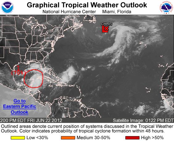
6 Debby- Formation well anticipated but where would it go
7 Debby Forms Diverging Forecast Guidance Tropical Storm Debby Track Guidance June 23, PM Advisory Texas or Florida?
8 Tropical Storm Debby Track Guidance June 23, PM Advisory Debby Advisory #2 Still Texas or Florida Consensus Models Split the Difference

9 Debby Advisory #4 Landfall indicated in 2-3 days by all models, but from Louisiana to Florida Tropical Storm Debby Track Guidance June 24, AM Advisory
10 Tropical Storm Debby Track Guidance June 24, PM Advisory Debby Advisory #6

11 NHC Forecasts First 4 forecasts head toward Texas, shift toward Florida was required


 Lake")
12 Debby Tornadoes 24 tornadoes reported in Florida Most occurred during an outbreak on June 24 Strongest were EF-2s in Venus (Highlands Co.) and Winter Haven (Polk Co.) St. Petersburg, FL (Oriana Sofia) Lake Placid, FL (Skip Dent)


13 Debby Storm Surge: 2 to 4.5 ft above normal levels Inundation: 1 to 3 ft above ground

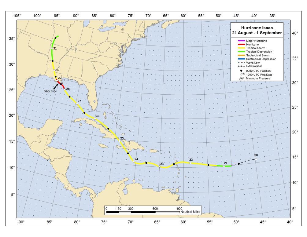

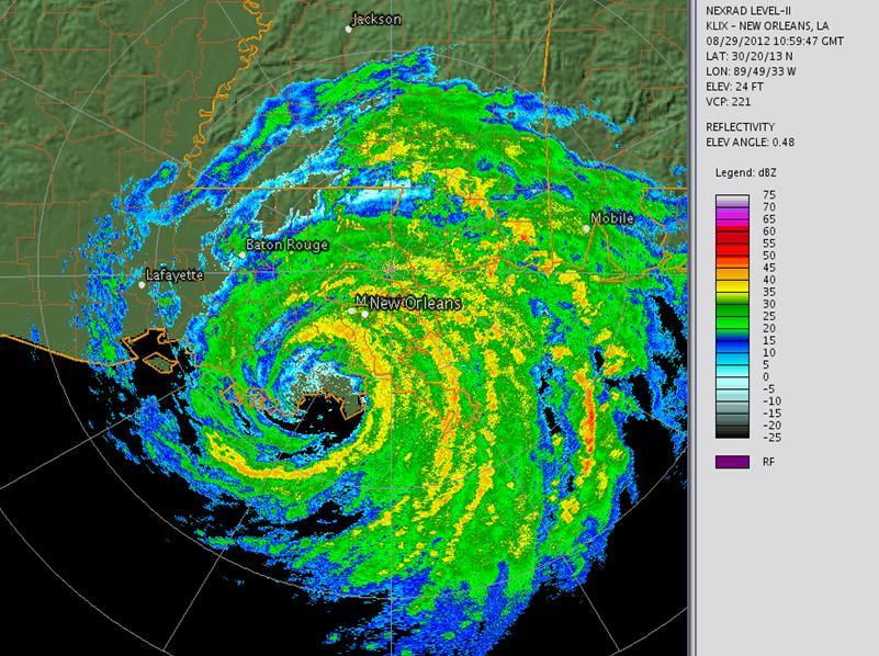
14 Hurricane Isaac
")

")

15 Braithwaite, Louisiana (Twitter/JMLeblanc23) Slidell, Louisiana (Michael DeMocker/Times- Picayune) Laplace, Louisiana (Michael DeMocker/Times- Picayune) Plaquemines Parish, Louisiana (Homeland Security Watch)
16 Isaac Track Guidance Five-day NHC forecast and guidance showed Isaac a threat to Florida

17 Isaac Track Guidance Guidance Shifted Westward- But large spread in potential landfall locations about 4 days out
18
19


 Union Beach,")
20 PATH station, Hoboken, NJ AFP PHOTO / The Port Authority of New York & New Jersey Harvey Cedars, Long Beach Island, New Jersey (AP Photo/The Philadelphia Inquirer, Clem Murray) Atlantic City, NJ (Tom Mihalek/Reuters) Union Beach, NJ (blog, Spleeness)

21 Many Challenges During Sandy But the Track and Intensity Forecasts Were Better than Average

,")
22 Rapid Intensification: A Recurring Challenge Sandy intensified rapidly between Jamaica and Cuba, and this was poorly forecast. Despite ongoing efforts (e.g. the Hurricane Forecast Improvement Program), forecasting rapid intensification remains a major problem.
23 Warning Challenge in Sandy The dynamical models forecast Sandy to become extratropical before landfall, although the timing varied. Once warnings are issued, it is difficult to switch between TC and non-tc warnings. There were several combinations of possible warnings and storm evolution, all of which were problematic. TC warnings were eventually issued for coastal North Carolina, with non-tc warnings for the rest of the affected area. During Sandy, the extratropical transition process did not reduce the threat at all!


24 Meeting the Warning Challenges for 2013 and Beyond The NWS has broadened the tropical storm and hurricane watch and warning definitions to allow them to be used for post-tropical cyclones that pose a significant risk to life and property. NHC will have the option to continue advisory products on post-tropical cyclones that pose a risk to life/property and when the transfer of responsibility to another office would result in an unacceptable discontinuity in service. For several years, the NWS has been developing a storm surge warning that could be used independently of the expected winds and of the type of weather system producing it. This could be operational by 2015.

25 Prototype of Storm Surge Warning

26 Potential Storm Surge Inundation Graphic
27 2013 Changes Definitions of TS and hurricane watches/warnings have been broaden and issuance criteria of advisories have changed to allow NHC the option to use both for post-tropical cyclones that pose a significant threat to life and property (discussed a couple of slides ago) New use of NHC s Tropical Cyclone Update (TCU) product replaces need for Position Estimate (TCE) Planned extension of Tropical Weather Outlook to 5 days Cone size has again been reduced


28 Tropical Cyclone Position Estimate HURRICANE IRENE TROPICAL CYCLONE POSITION ESTIMATE NWS NATIONAL HURRICANE CENTER MIAMI FL AL PM EDT SAT AUG AT 1000 PM EDT 0200 UTC THE CENTER OF HURRICANE IRENE WAS ESTIMATED BY AN AIR FORCE RESERVE HURRICANE HUNTER AIRCRAFT AND NOAA DOPPLER WEATHER RADAR TO BE NEAR LATITUDE 37.1 NORTH LONGITUDE 75.5 WEST....SUMMARY OF 1000 PM EDT INFORMATION... LOCATION N 75.5W ABOUT 270 MI 435 KM SSW OF NEW YORK CITY MAXIMUM SUSTAINED WINDS...80 MPH. PRESENT MOVEMENT...NNE OR 20 DEGREES AT 16 MPH MINIMUM CENTRAL PRESSURE MB $$ FORECASTER BRENNAN This product is issued between 2-hourly intermediate public advisories
29 Tropical Cyclone Update This product is issued when: (1) the cyclone makes landfall (2) unexpected changes occur in the cyclone (3) to issue international watches and warnings (4) now used for 1-hourly position estimates instead of TCE TROPICAL STORM CLAUDETTE TROPICAL CYCLONE UPDATE NWS TPC/NATIONAL HURRICANE CENTER MIAMI FL AL PM EDT SUN AUG DEPRESSION BECOMES TROPICAL STORM CLAUDETTE... DATA FROM THE NOAA DOPPLER RADAR IN TALLAHASSEE FLORIDA INDICATE THAT SURFACE WINDS ASSOCIATED WITH THE DEPRESSION HAVE INCREASED TO 40 MPH...65 KM/HR...MAKING THE DEPRESSION TROPICAL STORM CLAUDETTE....SUMMARY OF 1215 PM AST INFORMATION... LOCATION N 84.6W MAXIMUM SUSTAINED WINDS...40 MPH PRESENT MOVEMENT...NORTHWEST OR 320 DEGREES AT 14 MPH MINIMUM CENTRAL PRESSURE MB $$ FORECASTER ROBERTS/BRENNAN

30 How will the Outlook change in 2013? Additional information about the 0 to 5 day formation potential will be included in the Text TWO THIS SYSTEM HAS A MEDIUM CHANCE 40 PERCENT OF BECOMING A TROPICAL CYCLONE DURING THE NEXT 48 HOURS THIS SYSTEM HAS A HIGH CHANCE 80 PERCENT OF BECOMING A TROPICAL CYCLONE DURING THE NEXT 5 DAYS. - NHC still has some development and testing to complete. - This addition to the TWO is not planned to occur until July or August.
31 Prototype 5-day Graphic Might be available sometime in 2013


32 New Graphic Shows 5-day Potential Formation Area - Overview graphic shows entire basin, with single disturbance graphics to aid in display when overlapping areas - Indicates initial location of disturbance (X), if existing at issuance time - Existing 2-day graphical Outlook will remain unchanged

33 Represents probable track of tropical cyclone center but does not tell you anything about impacts! Formed by connecting circles centered on each forecast point (at 12, 24, 36 h, etc.) Size of the circles determined so that, for example, the actual storm position at 48 h will be within the 48-h circle 67% of the time NHC Forecast Cone
34 Atlantic Cone Radii 2013 vs Improving track accuracy = smaller cone size Forecast Period (h) 2012 Circle Radius (n mi) ( errors) 2013 Circle Radius (n mi) ( errors) Percent Change % % % % % % % Storm size has not changed = more impacts outside cone

35 Isaac Advisory 13 with 2008 Cone

36 Isaac Advisory 13 with 2013 Cone

37 Other Potential NHC Forecast Enhancements and Beyond Storm Surge Warning (2015) and Inundation Graphic Track and intensity forecasts for disturbances Watches/Warning before formation Extension of tropical cyclone forecasts to 7 days


38 Pre-Tropical Cyclone Track & Intensity Forecasts Motivation: Issued for systems prior to genesis in support of the watch/warning process In 2011, the NHC began making forecasts only for tropical disturbances with a high chance of formation in the Tropical Weather Outlook Forecasts include predictions of track, intensity, wind radii, and system status (e.g. TD/TS/HU, or DB ) out to 5 days Pre-Irene (2011) Forecast


39 Watches and Warnings before Formation? Prototype Graphics NHC conducted an in-house experiment during the 2012 season by issuing Pre-TC watches/warnings Could take a few years to have enough cases to evaluate NHC exploring ways to issue and communicate pre-tc watches & warnings Through graphical and text TWO? Through advisory-like products? New products?

40 6- and 7-Day Track Forecasts 2012 NHC 6- and 7-day Track Forecast Verification NHC 6- and 7- day forecasts had lower mean errors than the ECMWF and GFS models Day 6 mean error about 240 n mi Day 7 mean error about 300 n mi Day 6 Day 7
41 6- and 7-day Forecasts 300 n mi 240 n mi 2012 verification results indicate the 6- and 7-day forecasts were about as good as NHC 4- and 5-day forecasts were when introduced a decade ago.
42 6- and 7-day Forecasts for Sandy Were Initially Out to Sea Good model agreement through 72 h. More spread at days four through seven 7-day NHC Forecast 0000 UTC October 24
43 Forecasts Shifted Westward about 6 Days Before Landfall Large spread in track in track guidance at days 5, 6, and 7. ECMWF shows U.S. landfall, GFS on eastern edge of envelope 7-day NHC Forecast 0000 UTC October 25

44 Models in Better Agreement About 5-days from Landfall Guidance in much better agreement. All models show U.S. landfall UTC October 26


45 Social Media and NHC NHC Facebook & Twitter feed began in 2011 Hurricane Awareness Week- Public Service Announcements
46 Social Media and NHC Over 208,000 Facebook followers - One of the most followed government Facebook pages Currently over 111,000 Twitter followers Significantly increase of followers during hurricane threats Debby Ernesto Isaac Leslie Sandy Peaks of new NHC Facebook followers during 2012 hurricane season

47 Brown Thanks for your time! NHC Hurricane Forecasters Roberts Blake Pasch Beven Landsea Berg Avila Cangialosi Kimberlain Brennan Stewart Franklin Questions?
National Hurricane Center Products. Jack Beven National Hurricane Center
 National Hurricane Center Products Jack Beven National Hurricane Center Florida Governor s Hurricane Conference 11 May 2014 NHC Tropical Cyclone Products NHC provides the big picture that complements and
Wind Speed Probability Products. Daniel Brown and Michael Brennan National Hurricane Center
 Wind Speed Probability Products Daniel Brown and Michael Brennan National Hurricane Center 2017 WMO Course 7 March 2017 Wind Speed Probabilities A Tool to Deal with Uncertainty Hurricane Irene Advisory
RSMC-Miami Update Daniel Brown Warning Coordination Meteorologist
 RSMC-Miami Update 2016 Daniel Brown Warning Coordination Meteorologist L-0324 Emergency Management Hurricane Preparedness Training Course Funding provided by FEMA s National Hurricane Program - partnership
What s s New for 2009
 What s s New for 2009 Graphical Tropical Weather Outlook becomes operational Special Tropical Disturbance Statement replaced with Special Tropical Weather Outlook Tropical Cyclone Wind Field Graphic becomes
Wind Speed Probability Products
 Wind Speed Probability Products Daniel Brown National Hurricane Center 2018 WMO Course 6 March 2018 Wind Speed Probabilities A Tool to Deal with Uncertainty Hurricane Irene Advisory Number 12 Issued 5:00
Case Studies in Communication Challenges: Hurricane Sandy
 Case Studies in Communication Challenges: Hurricane Sandy International Workshop on Tropical Cyclones Jeju Island, South Korea Chris Landsea, National Hurricane Center, RSMC Miami Major Hurricane Sandy
WELCOME TO THE 2018 RA-IV WORKSHOP ON HURRICANE FORECASTING AND WARNING
 WELCOME TO THE 2018 RA-IV WORKSHOP ON HURRICANE FORECASTING AND WARNING Richard J. Pasch and Daniel P. Brown Senior Hurricane Specialists National Hurricane Center ORIENTATION Use of PCs NHC Facility Workshop
Storm Summary for Hurricane Jose
 Storm Summary for Hurricane Jose Tuesday, September 19, 2017 at 11 AM EDT (Output from Hurrevac, based on National Hurricane Center Forecast Advisory #57) Jose is currently a Category 1 hurricane on the
Frank Revitte National Weather Service. Weather Forecast Office New Orleans/Baton Rouge
 Frank Revitte National Weather Service Weather Forecast Office New Orleans/Baton Rouge Above normal activity 17 Total Named Storms 7 Tropical Storms 4 Hurricanes 6 Major Hurricanes Not the most active,
GC Briefing. Weather Sentinel Tropical Storm Michael. Status at 8 AM EDT (12 UTC) Today (NHC) Discussion. October 11, 2018
 Today (NHC) Discussion. October 11, 2018") GC Briefing Weather Sentinel Tropical Storm Michael October 11, 2018 After making landfall as a high-end category-4 hurricane on the Florida Panhandle, Michael weakened to tropical storm status early this
GC Briefing Weather Sentinel Tropical Storm Michael October 11, 2018 After making landfall as a high-end category-4 hurricane on the Florida Panhandle, Michael weakened to tropical storm status early this
Overview of Current Tropical Cyclone Products Generated by NWS
 Overview of Current Tropical Cyclone Products Generated by NWS Todd B. Kimberlain National Hurricane Center HFIP Ensembles Workshop Boulder, Colorado 20 April 2010 National Weather Service hurricane forecast
Storm Summary for Hurricane Joaquin
 Storm Summary for Hurricane Joaquin Wednesday, September 30, 2015 at 5 PM EDT (Output from Hurrevac, based on National Hurricane Center Forecast Advisory #12) Joaquin is currently a Category 1 hurricane
SIXTH INTERNATIONAL WORKSHOP on TROPICAL CYCLONES. Working Group: Phillipe Caroff, Jeff Callaghan, James Franklin, Mark DeMaria
 WMO/CAS/WWW Topic 0.1: Track forecasts SIXTH INTERNATIONAL WORKSHOP on TROPICAL CYCLONES Rapporteur: E-mail: Lixion A. Avila NOAA/National Hurricane Center 11691 SW 17th Street Miami, FL 33165-2149, USA
Tropical Update. 5 PM EDT Sunday, September 10, 2017 Hurricane Irma, Hurricane Jose, Tropical Wave (60%)
") Tropical Update 5 PM EDT Sunday, September 10, 2017 Hurricane Irma, Hurricane Jose, Tropical Wave (60%) This update is intended for government and emergency response officials, and is provided for informational
Tropical Update 5 PM EDT Sunday, September 10, 2017 Hurricane Irma, Hurricane Jose, Tropical Wave (60%) This update is intended for government and emergency response officials, and is provided for informational
Tropical Update. 12 PM EDT Friday, October 7, 2016 Hurricane Matthew & Tropical Storm Nicole
 Tropical Update 12 PM EDT Friday, October 7, 2016 Hurricane Matthew & Tropical Storm Nicole This update is intended for government and emergency response officials, and is provided for informational and
2017 Hurricane Season and Beyond
 2017 Hurricane Season and Beyond Ken Graham National Hurricane Center Building a Weather-Ready Nation Much of U.S. Coast Saw Tropical Wind Watches or Warnings 2017 Hurricane Season Facts and Figures 7th
Tropical Update. 11 AM EDT Tuesday, October 9, 2018 Hurricane Michael, Tropical Storm Leslie, Tropical Storm Nadine
 Tropical Update 11 AM EDT Tuesday, October 9, 2018 Hurricane Michael, Tropical Storm Leslie, Tropical Storm Nadine This update is intended for government and emergency response officials, and is provided
Tropical Update. 5 AM EDT Monday, October 8, 2018 Tropical Storm Michael, Tropical Storm Leslie, Invest 92L (10%) & African Tropical Wave (50%)
 & African Tropical Wave (50%)") Tropical Update 5 AM EDT Monday, October 8, 2018 Tropical Storm Michael, Tropical Storm Leslie, Invest 92L (10%) & African Tropical Wave (50%) This update is intended for government and emergency response
Tropical Update 5 AM EDT Monday, October 8, 2018 Tropical Storm Michael, Tropical Storm Leslie, Invest 92L (10%) & African Tropical Wave (50%) This update is intended for government and emergency response
Tropical Update 6 AM EDT Friday, October 7, 2016 Hurricane Matthew & Hurricane Nicole
 Tropical Update 6 AM EDT Friday, October 7, 2016 Hurricane Matthew & Hurricane Nicole This update is intended for government and emergency response officials, and is provided for informational and situational
Tropical Update. 5 PM EDT Tuesday, September 5, 2017 Hurricane Irma, Tropical Storm Jose, and Tropical Depression Thirteen
 Tropical Update 5 PM EDT Tuesday, September 5, 2017 Hurricane Irma, Tropical Storm Jose, and Tropical Depression Thirteen This update is intended for government and emergency response officials, and is
Hurricane Matthew Page 1 Location Forecast Analysis Summary Report - Advanced Wind Estimation On
 Page 1 Current NHC Forecast Predictions Maximum Sustained Winds / Storm Category: 138 MPH / Category 4 Forward motion: 9 mph towards the North Hurricane Force winds extend from the center: 46 miles Tropical
Tropical Update. 5 PM EDT Sunday, October 7, 2018 Tropical Storm Michael, Tropical Storm Leslie, & Invest 92L (30%)
") Tropical Update 5 PM EDT Sunday, October 7, 2018 Tropical Storm Michael, Tropical Storm Leslie, & Invest 92L (30%) This update is intended for government and emergency response officials, and is provided
Tropical Update 5 PM EDT Sunday, October 7, 2018 Tropical Storm Michael, Tropical Storm Leslie, & Invest 92L (30%) This update is intended for government and emergency response officials, and is provided
Tropical Update. 5 AM EDT Tuesday, September 12, 2017 Post-Tropical Cyclone Irma, Hurricane Jose, & Tropical Wave (10%)
") Tropical Update 5 AM EDT Tuesday, September 12, 2017 Post-Tropical Cyclone Irma, Hurricane Jose, & Tropical Wave (10%) This update is intended for government and emergency response officials, and is provided
Tropical Update 5 AM EDT Tuesday, September 12, 2017 Post-Tropical Cyclone Irma, Hurricane Jose, & Tropical Wave (10%) This update is intended for government and emergency response officials, and is provided
Tropical Weather Briefing
 Tropical Weather Briefing August 28, 2012 700 AM CDT National Weather Service Weather Forecast Office Slidell, LA Current Satellite Tropical Storm Isaac Watches/Warnings Tropical Storm Isaac Track Guidance
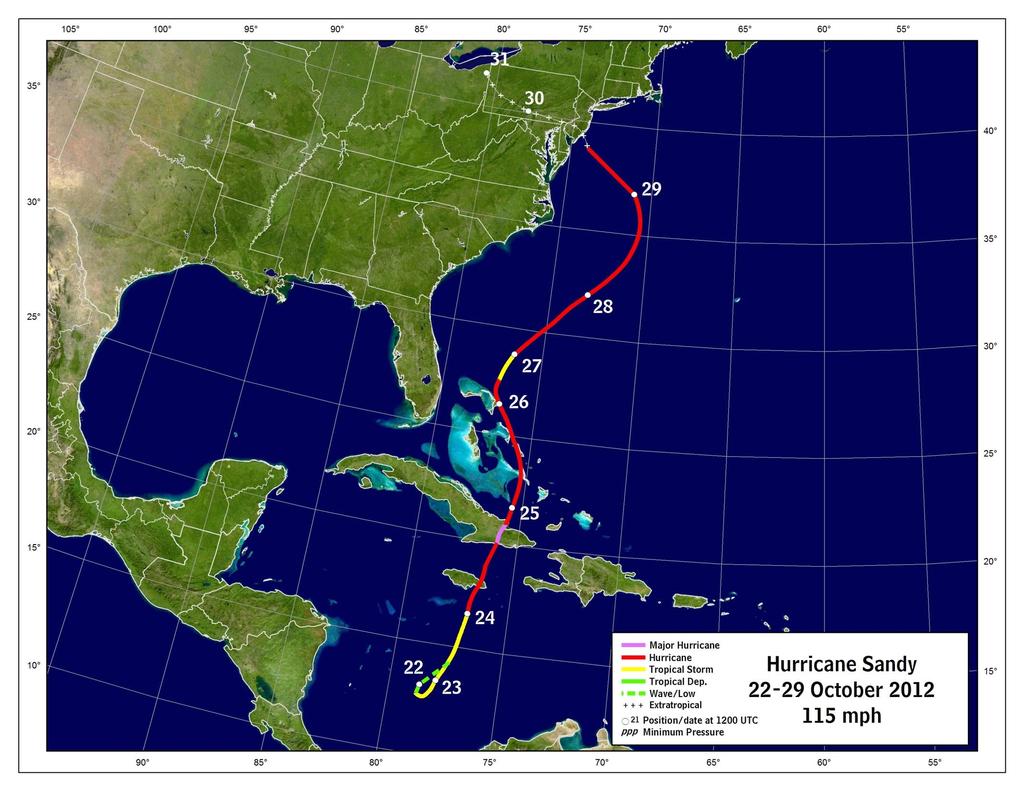
Hurricane Sandy October 28 th 31 st 2012
 Hurricane Sandy October 28 th 31 st 2012 Prepared 530 PM EDT Saturday October 27, 2012 Gary Szatkowski NOAA s NJ Forecast Office Weather.gov/phi Purpose of Briefing Briefing #7 for event Promote situational
WEEKLY WEATHER OUTLOOK BELIZE, CENTRAL AMERICA
 WEEKLY WEATHER OUTLOOK BELIZE, CENTRAL AMERICA PERIOD: Sunday, July 1 until Monday, July 9, 2012 DATE ISSUED: Sunday, July 1, 2012 3:00 pm RFrutos EcoSolutions & Services SYNOPSIS: The features of interest
Outlook 2008 Atlantic Hurricane Season. Kevin Lipton, Ingrid Amberger National Weather Service Albany, New York
 Outlook 2008 Atlantic Hurricane Season Kevin Lipton, Ingrid Amberger National Weather Service Albany, New York Summary 2007 Hurricane Season Two hurricanes made landfall in the Atlantic Basin at category-5
NHC Ensemble/Probabilistic Guidance Products
 NHC Ensemble/Probabilistic Guidance Products Michael Brennan NOAA/NWS/NCEP/NHC Mark DeMaria NESDIS/STAR HFIP Ensemble Product Development Workshop 21 April 2010 Boulder, CO 1 Current Ensemble/Probability
NWS HURRICANES June 3, 2015
 NWS HURRICANES June 3, 2015 Hurricane Season June 1 November 30 2 What s the concern? All tropical systems passing within 125nm of central Maryland since 1950 Mid-Atlantic Hurricanes Greatest Risk: August
COLORADO STATE UNIVERSITY FORECAST OF ATLANTIC HURRICANE ACTIVITY FROM AUGUST 17 AUGUST 30, 2012
 COLORADO STATE UNIVERSITY FORECAST OF ATLANTIC HURRICANE ACTIVITY FROM AUGUST 17 AUGUST 30, 2012 We expect that the next two weeks will be characterized by above-average amounts (greater than 130 percent)
Very Dangerous Coastal Storm Sandy October 28 th 31 st 2012
 Very Dangerous Coastal Storm Sandy October 28 th 31 st 2012 Prepared 600 PM EDT Monday October 29, 2012 Gary Szatkowski NOAA s NJ Forecast Office Weather.gov/phi Purpose of Briefing Briefing #11 for event
Tropical Update. 11 AM EDT Wednesday, October 10, 2018 Hurricane Michael, Hurricane Leslie & Tropical Storm Nadine, Caribbean Low (40%)
") Tropical Update 11 AM EDT Wednesday, October 10, 2018 Hurricane Michael, Hurricane Leslie & Tropical Storm Nadine, Caribbean Low (40%) This update is intended for government and emergency response officials,
Tropical Update 11 AM EDT Wednesday, October 10, 2018 Hurricane Michael, Hurricane Leslie & Tropical Storm Nadine, Caribbean Low (40%) This update is intended for government and emergency response officials,
HURREVAC Webinar Series Day 1 Intro to HURREVAC and General Overview of the Program. National Hurricane Program Training Course
 HURREVAC Webinar Series Day 1 Intro to HURREVAC and General Overview of the Program 2017 HURREVAC Webinar Series 1. Intro to HURREVAC and General Overview of the Program (August 7 th or 14 th ) 2. Evacuation
COLORADO STATE UNIVERSITY FORECAST OF ATLANTIC HURRICANE ACTIVITY FROM AUGUST 31 SEPTEMBER 13, 2012
 COLORADO STATE UNIVERSITY FORECAST OF ATLANTIC HURRICANE ACTIVITY FROM AUGUST 31 SEPTEMBER 13, 2012 We expect that the next two weeks will be characterized by average amounts (70-130 percent) of activity
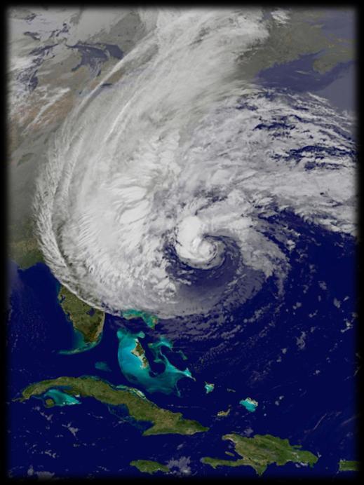
GOES-13 IMAGE OF HURRICANE SANDY AT 1745 UTC 28 OCTOBER ABSTRACT
 NATIONAL HURRICANE CENTER ANNUAL SUMMARY 2012 ATLANTIC HURRICANE SEASON Stacy Stewart 23 January 2014 GOES-13 IMAGE OF HURRICANE SANDY AT 1745 UTC 28 OCTOBER 2012. ABSTRACT The 2012 Atlantic hurricane
TROPICAL STORM NATE BRIEFING
 TROPICAL STORM NATE BRIEFING 5:00 AM CDT Friday, October 6, 2017 Prepared by: NWS NWSNewOrleans www.weather.gov/neworleans Situation Overview No significant changes to the track forecast this morning.
The Atlantic Hurricane Database Reanalysis Project
 The Atlantic Hurricane Database Reanalysis Project 9 November, 2015 14 th International Workshop on Wave Hindcasting and Forecasting Chris Landsea, National Hurricane Center, Miami, USA Chris.Landsea@noaa.gov
Hurricane Irma Page 1 HURRTRAK RM/Pro 2017 Summary Report for Tampa, FL 09/09/ EDT, Adv. # 43
 Hurricane Irma Page 1 Description of impact to Tampa, FL, Tampa, FL, is expected to receive a major impact from Hurricane Irma. The forecast maximum wind for this location has decreased since the last
Homework 2: Hurricane Katrina. Part 1. Hurricane Katrina, August 28, 2005 Satellite Imagery
 Metr 302 Homework 2 Fall 2014 Meteorology 302 Fall 2014 Name Homework 2: Hurricane Katrina 100 points total Distributed Thursday 30 October 2014; Due Thursday 13 November 2014 Answer all questions in complete
Tropical Update. 5 PM EDT Thursday, August 27, 2015 Tropical Storm Erika
 Tropical Update 5 PM EDT Thursday, August 27, 2015 Tropical Storm Erika This update is intended for government and emergency response officials, and is provided for informational and situational awareness
2006 ATLANTIC HURRICANE SUMMARY. Weather Research Center Houston, Texas
 2006 ATLANTIC HURRICANE SUMMARY Weather Research Center Houston, Texas Weather Research Center 5104 Caroline Houston, Texas 77004 Phone: 713-529-3076 Fax: 713-528-3538 E-mail: wrc@wxresearch.org 2006 Atlantic
Hurricane Irma Page 1 HURRTRAK RM/Pro 2017 Summary Report for Tampa, FL 09/10/ EDT, Adv. # 46
 Hurricane Irma Page 1 Description of impact to Tampa, FL, Tampa, FL, is expected to receive a major impact from Hurricane Irma. The forecast maximum wind for this location has increased since the last
2008 Hurricane Caravan. Daniel Noah Meteorologist National Weather Service x1 May 22, 2008
 2008 Hurricane Caravan Daniel Noah Meteorologist National Weather Service daniel.noah@noaa.gov, 813-645-2323 x1 May 22, 2008 National Weather Service We never close! Open 24 hours a day 365 days per year
Hurricane Matthew. National Weather Service Wilmington NC. Steven Pfaff, WCM.
 Hurricane Matthew Threat Assessment for northeast South Carolina & southeast North Carolina National Weather Service Wilmington NC 515 PM EDT Monday October 3, 2016 Steven Pfaff, WCM Steven.Pfaff@noaa.gov
Atlantic Basin Satellite Image
 Tropical Update 11 AM EDT Friday, September 7, 2018 Tropical Depression Gordon, Tropical Storm Florence, Potential Tropical Cyclone #8 (90%), Invest 92L (90%) This update is intended for government and
Hurricane Matthew. National Weather Service Wilmington NC. Steven Pfaff, WCM.
 Hurricane Matthew Threat Assessment for northeast South Carolina & southeast North Carolina National Weather Service Wilmington NC 730 AM EDT Tuesday October 4, 2016 Steven Pfaff, WCM Steven.Pfaff@noaa.gov
TROPICAL DEPRESSION HARVEY BRIEFING
 TROPICAL DEPRESSION HARVEY BRIEFING 10:15 PM CDT Wednesday, August 23, 2017 Prepared by: Lara Beal NWSCorpus www.weather.gov/corpuschristi Situation Overview No changes to Watches. Hurricane Watch remains
Tropical Update. 5 AM EDT Wednesday, September 6, 2017 Hurricane Irma, Tropical Storm Jose, and Tropical Storm Katia
 Tropical Update 5 AM EDT Wednesday, September 6, 2017 Hurricane Irma, Tropical Storm Jose, and Tropical Storm Katia This update is intended for government and emergency response officials, and is provided
GFDL Hurricane Model Ensemble Performance During the 2012 Hurricane Season
 GFDL Hurricane Model Ensemble Performance During the 2012 Hurricane Season Tim Marchok (NOAA / GFDL) Matt Morin (DRC HPTG / GFDL) Morris Bender (NOAA / GFDL) HFIP Team Telecon 12 December 2012 Acknowledgments:
HVX-HURREVAC (Beta) Webinar Series
 Webinar Series") HVX-HURREVAC (Beta) Webinar Series Day 1 - An introduction to HURREVAC and the new web-based HVX platform 2018 HVX-HURREVAC Webinar Series 1. Intro to HURREVAC and General Overview of the Program (August
HVX-HURREVAC (Beta) Webinar Series Day 1 - An introduction to HURREVAC and the new web-based HVX platform 2018 HVX-HURREVAC Webinar Series 1. Intro to HURREVAC and General Overview of the Program (August
Preliminary Assessment of 2017 Atlantic Hurricane Season. Phil Klotzbach. Department of Atmospheric Science. Phil Klotzbach
 Atlantic Basin Basin Tropical Seasonal Cyclone Hurricane Climatology Prediction and Preliminary Assessment of 2017 Atlantic Hurricane Season Phil Klotzbach Department of Atmospheric Science Colorado Phil
There is a Storm. What s the Info? National Weather Service Tropical Cyclone Products
 NHC Forecasts There is a Storm. What s the Info? National Weather Service Tropical Cyclone Products National Weather Service Tropical Cyclone Products NHC provides the big picture that complements and
Tropical Update. 5 PM EDT Thursday, September 7, 2017 Hurricane Irma, Hurricane Jose, and Hurricane Katia
 Tropical Update 5 PM EDT Thursday, September 7, 2017 Hurricane Irma, Hurricane Jose, and Hurricane Katia This update is intended for government and emergency response officials, and is provided for informational
Hurricane Isaac. National Weather Service. Communication Challenges and The Future. Weather Forecast Office New Orleans/Baton Rouge
 Hurricane Isaac Communication Challenges and The Future National Weather Service Weather Forecast Office New Orleans/Baton Rouge Hurricane Isaac Challenges 2012 Tropical Season Season was quiet for Louisiana
Tropical Update. 5 AM EDT Thursday, September 7, 2017 Hurricane Irma, Hurricane Jose, and Hurricane Katia
 Tropical Update 5 AM EDT Thursday, September 7, 2017 Hurricane Irma, Hurricane Jose, and Hurricane Katia This update is intended for government and emergency response officials, and is provided for informational
Tropical Storm Ana. Created 6:00 AM Sun May 10, 2015 John Cole Warning Coordination Meteorologist
 Tropical Storm Ana Threat Assessment for Eastern North Carolina Created 6:00 AM Sun May 10, 2015 John Cole Warning Coordination Meteorologist John.cole@noaa.gov National Weather Service Newport/Morehead
Early Guidance for Tropical Weather Systems
 Early Guidance for Tropical Weather Systems Understanding What s Out There Jennifer McNatt National Weather Service Material from: Dan Brown, Mike Brennan and John Cangialosi, National Hurricane Center
COLORADO STATE UNIVERSITY FORECAST OF ATLANTIC HURRICANE ACTIVITY FROM AUGUST 16 AUGUST 29, 2013
 COLORADO STATE UNIVERSITY FORECAST OF ATLANTIC HURRICANE ACTIVITY FROM AUGUST 16 AUGUST 29, 2013 We expect that the next two weeks will be characterized by above-average amounts (greater than 130 percent)
There is a Storm. What s the Info? National Weather Service Tropical Cyclone Products
 NHC Forecasts There is a Storm. What s the Info? National Weather Service Tropical Cyclone Products National Weather Service Tropical Cyclone Products NHC provides the big picture that complements and
WEEKEND WEATHER OUTLOOK BELIZE, CENTRAL AMERICA
 WEEKEND WEATHER OUTLOOK BELIZE, CENTRAL AMERICA PERIOD: Friday, July 6 until Monday, July 9, 2012 DATE ISSUED: Friday, July 6, 2012; 9:00 am RFrutos SYNOPSIS: An active tropical wave (TW) just west of
August Forecast Update for Atlantic Hurricane Activity in 2016
 August Forecast Update for Atlantic Hurricane Activity in 2016 Issued: 5 th August 2016 by Professor Mark Saunders and Dr Adam Lea Dept. of Space and Climate Physics, UCL (University College London), UK
HURRICANE SURVIVAL KIT
 HURRICANE SURVIVAL KIT DEFINITION-A hurricane is a very vast and powerful storm that originates in the tropics of the Atlantic Ocean. They become hurricanes when the sustained winds associated with it
Forecast Challenges of the 2017 Hurricane Season and NHC Priorities for 2018
 Forecast Challenges of the 2017 Hurricane Season and NHC Priorities for 2018 Michael J. Brennan, Mark DeMaria, Eric S. Blake, Richard J. Pasch, Andrew Penny Annual HFIP Meeting 8 November 2017 Outline
Hurricane Harvey: SE Texas Impacts. 10 PM CDT UPDATE Friday, August 25, 2017 Prepared by: Lance Wood
 Hurricane Harvey: SE Texas Impacts 10 PM CDT UPDATE Friday, August 25, 2017 Prepared by: Lance Wood Latest Observations Hurricane Harvey making landfall this evening near Rockport as a category 4 hurricane.
WEEKEND WEATHER OUTLOOK BELIZE, CENTRAL AMERICA
 WEEKEND WEATHER OUTLOOK BELIZE, CENTRAL AMERICA PERIOD: Friday, July 13 until Monday, July 16, 2012 DATE ISSUED: Friday, June 13, 2012, 9:00 am RFrutos SYNOPSIS: A weak pressure gradient over the NW Caribbean
An upper to mid level circulation (Low) in the NW Caribbean is
 in the NW Caribbean is") WEEKLY WEATHER OUTLOOK BELIZE, CENTRAL AMERICA PERIOD: Monday-Monday, Oct. 1 October 8, 2012 DATE ISSUED: Monday, Oct 1, 2012 6:00 am RFrutos EcoSolutions & Services SYNOPSIS: An upper to mid level circulation
WEEKLY WEATHER OUTLOOK BELIZE, CENTRAL AMERICA PERIOD: Monday-Monday, Oct. 1 October 8, 2012 DATE ISSUED: Monday, Oct 1, 2012 6:00 am RFrutos EcoSolutions & Services SYNOPSIS: An upper to mid level circulation
Communicating Hurricane Threats and Impacts on a National Scale. Daniel Brown Warning Coordination Meteorologist National Hurricane Center
 Communicating Hurricane Threats and Impacts on a National Scale Daniel Brown Warning Coordination Meteorologist National Hurricane Center New NWS Products to Help Communicate Potential Impacts New probabilistic
Superstorm Sandy. Joe Sienkiewicz NOAA Ocean Prediction Center
 Superstorm Sandy Joe Sienkiewicz NOAA Ocean Prediction Center Thanks to: Dr. Louis Uccellini, NCEP Director Dr. David Novak, HPC Dr. Richard Knabb, NHC Director Evolution Jet Stream 10/29/12 12Z (Blue)
Tropical Storm Harvey: SE Texas Impacts
 Tropical Storm Harvey: SE Texas Impacts 10 AM CDT UPDATE Thursday, August 24, 2017 Prepared by: Dan Reilly, Brian Kyle PLEASE MUTE YOUR LINES AND DON T PUT ON HOLD! Situation Overview Tropical Storm Harvey
10 years after Hurricane Charley
 10 years after Hurricane Charley Hurricane Charley (2004) A Retrospective Scott M. Spratt Warning Coordination Meteorologist NWS Melbourne, FL Florida Governors Hurricane Conference May 15, 2014 11 AM
NHC Ocean Vector Winds Update
 NHC Ocean Vector Winds Update Michael J. Brennan NOAA/NWS/NCEP National Hurricane Center International Ocean Vector Winds Science Team Meeting Portland, Oregon, 20 May 2015 Current Status NHC is currently
OPERATIONAL CONSIDERATIONS FOR HURRICANE MODEL DIAGNOSTICS / VERIFICATION
 OPERATIONAL CONSIDERATIONS FOR HURRICANE MODEL DIAGNOSTICS / VERIFICATION Richard J. Pasch National Hurricane Center Hurricane Diagnostics and Verification Workshop Miami, Florida 4 May 2009 NOAA/NESDIS
Storm Surge Forecast with Shifting Forecast Tracks
 Storm Surge Forecast with Shifting Forecast Tracks Storm Surge Findings in the Florida Keys Jon Rizzo Warning Coordination Meteorologist National Weather Service Florida Keys Florida Keys Life History
Hurricane Charley: A Retrospective 2014 Florida Governor s Hurricane Conference
 Hurricane Charley: A Retrospective 2014 Florida Governor s Hurricane Conference 2004 Hurricane Season: Storm Tracks Satellite Images of 2004 Hurricanes Charley Frances Ivan Jeanne Three Hurricanes in Polk
Canadian Hurricane Center: How NHC Products are used to issue Warnings and Communicate Hazards
 Canadian Hurricane Center: How NHC Products are used to issue Warnings and Communicate Hazards Bob Robichaud Warning Preparedness Meteorologist Canadian Hurricane Centre Contents Brief background on the
P1.14 THE SPATIAL PATTERNS OF RAINFALL PRODUCED BY HURRICANE IRENE (2011) AND OTHER TROPICAL CYCLONES WITH SIMILAR TRACKS
 AND OTHER TROPICAL CYCLONES WITH SIMILAR TRACKS") P1.14 THE SPATIAL PATTERNS OF RAINFALL PRODUCED BY HURRICANE IRENE (2011) AND OTHER TROPICAL CYCLONES WITH SIMILAR TRACKS Corene J. Matyas * University of Florida, Gainesville, Florida 1. INTRODUCTION
P1.14 THE SPATIAL PATTERNS OF RAINFALL PRODUCED BY HURRICANE IRENE (2011) AND OTHER TROPICAL CYCLONES WITH SIMILAR TRACKS Corene J. Matyas * University of Florida, Gainesville, Florida 1. INTRODUCTION
GC Briefing. Weather Sentinel Hurricane Florence. Status at 5 PM EDT (21 UTC) Today (NHC) Discussion. September 13, 2018
 Today (NHC) Discussion. September 13, 2018") GC Briefing September 13, 2018 Weather Sentinel Hurricane Florence Tropical storm conditions have been reported for areas of North Carolina and will continue to spread inland to the west and south. Hurricane
GC Briefing September 13, 2018 Weather Sentinel Hurricane Florence Tropical storm conditions have been reported for areas of North Carolina and will continue to spread inland to the west and south. Hurricane
COLORADO STATE UNIVERSITY FORECAST OF ATLANTIC HURRICANE ACTIVITY FROM AUGUST 18-31, 2017
 COLORADO STATE UNIVERSITY FORECAST OF ATLANTIC HURRICANE ACTIVITY FROM AUGUST 18-31, 2017 We expect that the next two weeks will be characterized by above-average amounts (>130%) of activity relative to
Weekend Outlook Belize, Central America Valid for: Friday until Monday, May 25-28, 2012
 Weekend Outlook Belize, Central America Valid for: Friday until Monday, May 25-28, 2012 RFrutos Synopsis: Conditions this past week improved by Wednesday as a surface low and trough producing the showery
(April 7, 2010, Wednesday) Tropical Storms & Hurricanes Part 2
 Tropical Storms & Hurricanes Part 2") Lecture #17 (April 7, 2010, Wednesday) Tropical Storms & Hurricanes Part 2 Hurricane Katrina August 2005 All tropical cyclone tracks (1945-2006). Hurricane Formation While moving westward, tropical disturbances
Lecture #17 (April 7, 2010, Wednesday) Tropical Storms & Hurricanes Part 2 Hurricane Katrina August 2005 All tropical cyclone tracks (1945-2006). Hurricane Formation While moving westward, tropical disturbances
The National Hurricane Center
 The National Hurricane Center Where we are and where we hope to go Bill Read, Director National Hurricane Center U.S. HURRICANE FORECAST SERVICE HISTORY MODERN ERA HIGHLIGHTS 1935: Began 24 hour forecast
Ch. 11: Hurricanes. Be able to. Define what hurricane is. Identify the life and death of a hurricane. Identify the ways we track hurricanes.
 Ch. 11: Hurricanes Be able to Define what hurricane is. Identify the life and death of a hurricane. Identify the ways we track hurricanes. What are Hurricanes? Smaller than mid-latitude cyclones. Don t
COLORADO STATE UNIVERSITY FORECAST OF ATLANTIC HURRICANE ACTIVITY FROM SEPTEMBER 15 SEPTEMBER 28, 2015
 COLORADO STATE UNIVERSITY FORECAST OF ATLANTIC HURRICANE ACTIVITY FROM SEPTEMBER 15 SEPTEMBER 28, 2015 We expect that the next two weeks will be characterized by below-average amounts (
Hurricane Matthew. Life Threatening Flash Flooding Likely. National Weather Service Wilmington NC. Josh Weiss, Meteorologist
 Hurricane Matthew Life Threatening Flash Flooding Likely Threat Assessment for northeast South Carolina & southeast North Carolina National Weather Service Wilmington NC 630 PM EDT Friday October 7, 2016
Prolonged Coastal Storm October 9 th -12 th, 2013
 Prolonged Coastal Storm October 9 th -12 th, 2013 Prepared 400 PM EDT Tuesday, October 8th, 2013 Gary Szatkowski NOAA s NJ Forecast office http://www.erh.noaa.gov/phi/ Purpose of Briefing Briefing #1 for
ERTH 365 Homework #2: Hurricane Harvey. 100 points
 ERTH 365 Homework #2: Hurricane Harvey 100 points Due by 6pm, Tuesday 30 October 2018, ELECTRONIC SUBMISSON BY EMAIL ONLY BY 6PM (send to klevey@sfsu.edu) (acceptable formats: MS Word, Google Doc, plain
Active Weather Threat Halloween Week Nor easter October 28 th 31 st 2012
 Active Weather Threat Halloween Week Nor easter October 28 th 31 st 2012 Prepared 1130 AM EDT Wednesday, October 24, 2012 Gary Szatkowski NOAA s NJ Forecast Office Weather.gov/phi Purpose of Briefing Briefing
Hurricane Matthew Life Threatening Flash Flooding Likely
 Hurricane Matthew Life Threatening Flash Flooding Likely Threat Assessment for northeast South Carolina & southeast North Carolina National Weather Service Wilmington NC 12 AM EDT Saturday October 8, 2016
Lessons Learned from Hurricane Harvey and Irma
 EOL Visit to NSF 3 March 2016 Lessons Learned from Hurricane Harvey and Irma Wen-Chau Lee National Center for Atmospheric Research 23 November 2017 Outline: Meteorological elements of the active 2017 Atlantic
HURRICANE IRMA. 12 PM ET Saturday, September Prepared by: Kyle Thiem / Sid King.
 HURRICANE IRMA 12 PM ET Saturday, September 9 2017 Prepared by: Kyle Thiem / Sid King www.weather.gov/atlanta/briefings @NWSAtlanta www.weather.gov/atlanta Situation Overview 11:00 AM EDT Sat Sep 9 Location:
Standardizing hurricane size descriptors for broadcast to the public
 Standardizing hurricane size descriptors for broadcast to the public Lori Drake, Hurricane Roadmap Project AMS 40th Conference on Broadcast Meteorology August 22-24, 2012, Boston, MA, Operational Forecasting
1C.4 TROPICAL CYCLONE TORNADOES: SYNOPTIC SCALE INFLUENCES AND FORECASTING APPLICATIONS
 1C.4 TROPICAL CYCLONE TORNADOES: SYNOPTIC SCALE INFLUENCES AND FORECASTING APPLICATIONS Daniel J. Cecil and Lori A. Schultz University of Alabama in Huntsville, Huntsville, AL, 35805 1. INTRODUCTION Several
Communications and Lessons Learned from
 Weather Forecast Office Charleston, SC Communications and Lessons Learned from Southeast and Caribbean and Climate Community of Practice - April, 2017 Public Information and Communications During Extremes
COLORADO STATE UNIVERSITY FORECAST OF ATLANTIC HURRICANE ACTIVITY FROM SEPTEMBER 27-OCTOBER 10, 2018
 COLORADO STATE UNIVERSITY FORECAST OF ATLANTIC HURRICANE ACTIVITY FROM SEPTEMBER 27-OCTOBER 10, 2018 We expect that the next two weeks will be characterized by above-normal amounts of hurricane activity,
WEEKLY WEATHER OUTLOOK BELIZE, CENTRAL AMERICA
 WEEKLY WEATHER OUTLOOK BELIZE, CENTRAL AMERICA PERIOD: Sunday, June 17 until Monday, June 25, 2012 DATE ISSUED: Sunday, June 17, 2012; 3:00 pm RFrutos EcoSolutions & Services SYNOPSIS: An upper level trough
Forecasting Atlantic Hurricanes at The. National Hurricane Centre. Centre. Chris Landsea Science and Operations Officer.
 Forecasting Atlantic Hurricanes at The National Hurricane Centre Chris Landsea Science and Operations Officer National Hurricane Centre 16 June, 2010 Forecasting Atlantic Hurricanes at The National Hurricane
El Niño Update Impacts on Florida
 Current Issues in Emergency Management (CIEM) Sessions 1 &2 October 12 th and 26 th, 2006 Florida Division of Emergency Management Tallahassee, Florida El Niño Update Impacts on Florida Bart Hagemeyer
Fort Rucker Wx Operations
 Spring & Summer Weather Hazards Fort Rucker Wx Operations Overview Hours of Operation OWS vs FRWXOPS Products Services Climatology Seasonal Patterns Seasonal Hazards Hours of Operation Observing 24/7 (automated)
Charles Kuster Leadville, CO. Personal Overview
 Charles Kuster Leadville, CO Personal Overview Personal Overview Charles Kuster Leadville, CO OU to study meteorology Charles Kuster Leadville, CO Personal Overview OU to study meteorology Graduated in
The Wind Hazard: Messaging the Wind Threat & Corresponding Potential Impacts
 The Wind Hazard: Messaging the Wind Threat & Corresponding Potential Impacts Scott Spratt Warning Coordination Meteorologist NWS Melbourne, FL David Sharp Science & Operations Officer NWS Melbourne, FL