WELCOME TO THE 2018 RA-IV WORKSHOP ON HURRICANE FORECASTING AND WARNING
|
|
|
- Scott McDowell
- 5 years ago
- Views:
Transcription


1 WELCOME TO THE 2018 RA-IV WORKSHOP ON HURRICANE FORECASTING AND WARNING Richard J. Pasch and Daniel P. Brown Senior Hurricane Specialists National Hurricane Center


2 ORIENTATION Use of PCs NHC Facility Workshop Introduction Outline Campus Map Overview of Workshop INTRODUCTION OF PARTICIPANTS OVERVIEW OF NHC ORGANIZATION ENHANCEMENTS TO NHC PRODUCTS TOUR


3 Use of PCs: Presentations available on Google Drive in folder WMO2018; to access this drive, click on WMO2018-Google Drive icon on your PC desktop Download to your PC desktop folder WMO2018 for viewing in PowerPoint by right clicking on files and selecting download Should you get logged off of Google, get back on with username raivworkshop and password 20Cloud13 (this is also our WiFi password)


4 NHC Facility Sign in/sign out Restrooms Breaks & Food Campus map

5 Introduction of Participants 21 countries & WMO Represented NAME ORGANIZATION CITY, COUNTRY DUTIES WHAT WOULD YOU LIKE TO GET FROM THIS WORKSHOP?
 NHC is one of 7 RSMCs that produce")

6 World Meteorological Organization Regional Specialized Meteorological Centers (RSMC) NHC is one of 7 RSMCs that produce and coordinate tropical cyclone forecasts for various ocean basins. NHC is responsible for both the Atlantic and eastern North Pacific Ocean basins.
, abroad), and issue and tropical")


7 National Hurricane Center Organizational Structure Hurricane Specialists Unit Develop, coordinate (domestically and and abroad), abroad), and issue and tropical issue tropical cyclone warnings, cyclone forecasts, warnings, and forecasts, outlooks in and text and outlooks graphical in formats, text and mostly on a six-hour cycle; graphical formats (~700 full advisory packages/yr) Off-season outreach; Applied research and public awareness Off-season programs. outreach and public awareness programs Applied research Tropical Analysis and Forecast Branch Marine/ocean and satellite analyses, forecasts and warnings in text and graphical formats, 24x7, (~100 products/day) Conduct tropical cyclone (Dvorak) analyses for the hurricane specialists Augments operational support staffing Technology and Science Branch Computer systems support 24x7 Applications development and technology infusion Storm surge guidance (real time; community planning; preparedness) Emergency operational support staffing
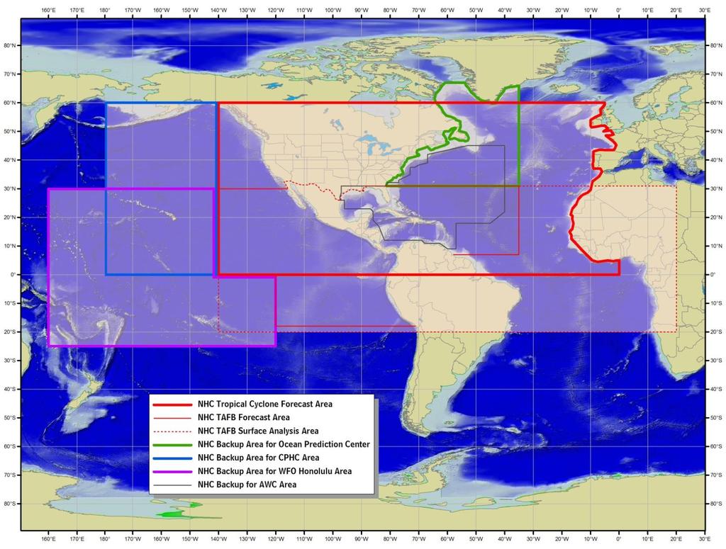
8 NHC Areas of Responsibility


9 Briefing Responders Briefings conducted shortly after the release of the forecasts- 5 & 11 AM/PM FEMA s Hurricane Liaison Team (HLT) State Department briefings U.S. and international media interviews & press briefings Local and State emergency management briefings


10 Briefing the Media Media pool opens whenever there is a hurricane watch/warning in effect for the U.S. NHC Director or spokesperson provides interviews to local or national media outlets in 5 minute windows Top of the hour generic briefings and podcasts are available


11 International Collaboration Highlights Open exchange of meteorological data among countries NHC provides forecasts and guidance on watches and warnings to 30 WMO member nations NHC hosts and teaches two-week workshop on tropical cyclones for international government meteorologists. NHC Director serves as Chairman of the WMO RA-IV Hurricane Committee. Annual meeting updates the Region s Hurricane Operational Plan U.S. conducts annual Caribbean Hurricane Awareness Tour Storm surge demonstration project for Hispaniola


12 2018 Caribbean Hurricane Awareness Tour Expected Stops La Paz, Mexico - April 23 Zihuatanejo, Mexico - April 24 Panama City, Panama - April 26 Montego Bay, Jamaica - April 27 Aquadilla, Puerto Rico - April 28 Opportunity to increase hurricane awareness by meeting with emergency managers, media, and general public Tour of hurricane hunter aircraft
13 NHC s International Coordination World MET. ORGANIZATION - Regional Association IV Coordination RSMC= Regional Specialized Meteorological Center RA-IV countries include Caribbean area, Central America, Mexico, Canada, and Bermuda.


14 Coordination of International Watches & Warnings Each country is responsible for issuing watches/warning for their respective country or jurisdiction NHC issues watches/warnings for Haiti NHC will recommend the placement of watches/warnings Coordinated via phone with Met. Offices throughout the region Tropical Storm or Hurricane Watches and Warnings are currently not issued prior to the formation of a tropical depression


15 National Hurricane Center Update 2018 Daniel Brown Warning Coordination Meteorologist
16 NHC Public Advisory Hurricane Maria Advisory #2 5 PM Saturday September 16 DISCUSSION AND OUTLOOK At 500 PM AST (2100 UTC), the center of Tropical Storm Maria was located near latitude 12.3 North, longitude 52.6 West. Maria is moving toward the west near 20 mph (31 km/h). A slower west-northwest motion is expected during the next several days. On the forecast track, Maria is expected to pass over portions of the Leeward Islands late Monday, and be near the Northern Leeward Islands on Tuesday. Maria is forecast to pass near or over the Virgin Islands and Puerto Rico on Wednesday, and could be near the Dominican Republic later this week. Maximum sustained winds have increased to near 50 mph (85 km/h) with higher gusts. Additional strengthening is expected during the next several days, and Maria is forecast to be a hurricane when it approaches the Leeward Islands. Maria could be a major hurricane when it is near the Northern Leeward Islands, the Virgin Islands, and Puerto Rico next week. New format provides forecast information to 72 h and beyond
 wind radii forecasts")


17 Extension of Hurricane-Force Wind Radii Forecasts Beginning in 2018, NHC will provide 48-h hurricane-force (64 kt) wind radii forecasts (in quadrants) This change should assist forecasters in placing hurricane watches and warnings Previously, NHC provided hurricaneforce wind radii forecasts out to 36 hours Forecast Time 34 kt 50 kt 64 kt 12 hr 24 hr 36 hr 48 hr 72 hr N/A 96 hr N/A N/A N/A 120 hr N/A N/A N/A

18 Time of Arrival Graphics Become Operational in 2018 Shows earliest reasonable arrival time of TS winds (black contours) and cumulative TS wind speed probabilities (colors) Identifies the time window that users at individual locations can safely assume will be free from TS winds Based on the time that has 10% chance of seeing sustained TS winds before the indicated time Earliest Reasonable Arrival of TS Winds Best for users with low tolerance for risk
19 Time of Arrival Graphics Become Operational in 2018 Shows most likely arrival time of TS winds (black contours) and cumulative TS wind speed probabilities (colors) Shows the time before or after which the onset of sustained TS winds is equally likely Best for users that are willing to risk not having completed preparations before TS winds arrive Most Likely Arrival of TS Winds


20 Potential Tropical Cyclone Advisories Allows the timely issuance of watches/warnings before a tropical cyclone has formed Used before the formation of 7 systems in the Atlantic basin in 2017, 6 of those became tropical cyclones Was used for the very first time in the Caribbean region, for the systems that became Tropical Storm Bret and Hurricane Maria


21 Key Message Graphic and Initial Wind Field on Cone Graphic NHC Key Message Graphic Combines Key Messages from the NHC Discussion and pertinent advisory graphics Available via NHC social media accounts and on NHC website Storm size information (initial wind field) was added to the cone graphic in 2017 Helped to illustrate hazardous wind conditions that occur outside the cone

22 Tour of NHC, CARCAH, WFO, and HLT
Tropical Update. 5 PM EDT Tuesday, September 5, 2017 Hurricane Irma, Tropical Storm Jose, and Tropical Depression Thirteen
 Tropical Update 5 PM EDT Tuesday, September 5, 2017 Hurricane Irma, Tropical Storm Jose, and Tropical Depression Thirteen This update is intended for government and emergency response officials, and is
Canadian Hurricane Center: How NHC Products are used to issue Warnings and Communicate Hazards
 Canadian Hurricane Center: How NHC Products are used to issue Warnings and Communicate Hazards Bob Robichaud Warning Preparedness Meteorologist Canadian Hurricane Centre Contents Brief background on the
RSMC-Miami Update Daniel Brown Warning Coordination Meteorologist
 RSMC-Miami Update 2016 Daniel Brown Warning Coordination Meteorologist L-0324 Emergency Management Hurricane Preparedness Training Course Funding provided by FEMA s National Hurricane Program - partnership
Wind Speed Probability Products
 Wind Speed Probability Products Daniel Brown National Hurricane Center 2018 WMO Course 6 March 2018 Wind Speed Probabilities A Tool to Deal with Uncertainty Hurricane Irene Advisory Number 12 Issued 5:00
Wind Speed Probability Products. Daniel Brown and Michael Brennan National Hurricane Center
 Wind Speed Probability Products Daniel Brown and Michael Brennan National Hurricane Center 2017 WMO Course 7 March 2017 Wind Speed Probabilities A Tool to Deal with Uncertainty Hurricane Irene Advisory
Tropical Update. 5 AM EDT Wednesday, September 6, 2017 Hurricane Irma, Tropical Storm Jose, and Tropical Storm Katia
 Tropical Update 5 AM EDT Wednesday, September 6, 2017 Hurricane Irma, Tropical Storm Jose, and Tropical Storm Katia This update is intended for government and emergency response officials, and is provided
Tropical Update. 5 AM EDT Monday, October 8, 2018 Tropical Storm Michael, Tropical Storm Leslie, Invest 92L (10%) & African Tropical Wave (50%)
 & African Tropical Wave (50%)") Tropical Update 5 AM EDT Monday, October 8, 2018 Tropical Storm Michael, Tropical Storm Leslie, Invest 92L (10%) & African Tropical Wave (50%) This update is intended for government and emergency response
Tropical Update 5 AM EDT Monday, October 8, 2018 Tropical Storm Michael, Tropical Storm Leslie, Invest 92L (10%) & African Tropical Wave (50%) This update is intended for government and emergency response
National Hurricane Center Products. Jack Beven National Hurricane Center
 National Hurricane Center Products Jack Beven National Hurricane Center Florida Governor s Hurricane Conference 11 May 2014 NHC Tropical Cyclone Products NHC provides the big picture that complements and
Tropical Update. 5 AM EDT Thursday, September 7, 2017 Hurricane Irma, Hurricane Jose, and Hurricane Katia
 Tropical Update 5 AM EDT Thursday, September 7, 2017 Hurricane Irma, Hurricane Jose, and Hurricane Katia This update is intended for government and emergency response officials, and is provided for informational
Tropical Update. 5 PM EDT Thursday, August 27, 2015 Tropical Storm Erika
 Tropical Update 5 PM EDT Thursday, August 27, 2015 Tropical Storm Erika This update is intended for government and emergency response officials, and is provided for informational and situational awareness
Tropical Update. 11 AM EDT Tuesday, October 9, 2018 Hurricane Michael, Tropical Storm Leslie, Tropical Storm Nadine
 Tropical Update 11 AM EDT Tuesday, October 9, 2018 Hurricane Michael, Tropical Storm Leslie, Tropical Storm Nadine This update is intended for government and emergency response officials, and is provided
Frank Revitte National Weather Service. Weather Forecast Office New Orleans/Baton Rouge
 Frank Revitte National Weather Service Weather Forecast Office New Orleans/Baton Rouge Above normal activity 17 Total Named Storms 7 Tropical Storms 4 Hurricanes 6 Major Hurricanes Not the most active,
Tropical Update. 5 PM EDT Sunday, October 7, 2018 Tropical Storm Michael, Tropical Storm Leslie, & Invest 92L (30%)
") Tropical Update 5 PM EDT Sunday, October 7, 2018 Tropical Storm Michael, Tropical Storm Leslie, & Invest 92L (30%) This update is intended for government and emergency response officials, and is provided
Tropical Update 5 PM EDT Sunday, October 7, 2018 Tropical Storm Michael, Tropical Storm Leslie, & Invest 92L (30%) This update is intended for government and emergency response officials, and is provided
Tropical Update. 5 AM EDT Tuesday, September 12, 2017 Post-Tropical Cyclone Irma, Hurricane Jose, & Tropical Wave (10%)
") Tropical Update 5 AM EDT Tuesday, September 12, 2017 Post-Tropical Cyclone Irma, Hurricane Jose, & Tropical Wave (10%) This update is intended for government and emergency response officials, and is provided
Tropical Update 5 AM EDT Tuesday, September 12, 2017 Post-Tropical Cyclone Irma, Hurricane Jose, & Tropical Wave (10%) This update is intended for government and emergency response officials, and is provided
photo courtesy of
 BRITISH VIRGIN ISLANDS REPORT TROPICAL STORM JEANNE photo courtesy of www.bviplatinum.com PREPARED BY THE DEPARTMENT OF DISASTER MANAGEMENT 1 EVENT 13 th -16 th September, 2004 TROPICAL STORM JEANNE Sequence
A Look Back at the 2012 Hurricane Season and a Look Ahead to 2013 & Beyond. Daniel Brown National Hurricane Center Miami, Florida 24 April 2013
 A Look Back at the 2012 Hurricane Season and a Look Ahead to 2013 & Beyond Daniel Brown National Hurricane Center Miami, Florida 24 April 2013 2012 Atlantic Verification Good News- Lots of Accuracy Records
Atlantic Basin Satellite Image
 Tropical Update 11 AM EDT Friday, September 7, 2018 Tropical Depression Gordon, Tropical Storm Florence, Potential Tropical Cyclone #8 (90%), Invest 92L (90%) This update is intended for government and
Tropical Update. 5 PM EDT Sunday, September 10, 2017 Hurricane Irma, Hurricane Jose, Tropical Wave (60%)
") Tropical Update 5 PM EDT Sunday, September 10, 2017 Hurricane Irma, Hurricane Jose, Tropical Wave (60%) This update is intended for government and emergency response officials, and is provided for informational
Tropical Update 5 PM EDT Sunday, September 10, 2017 Hurricane Irma, Hurricane Jose, Tropical Wave (60%) This update is intended for government and emergency response officials, and is provided for informational
WEDNESDAY 30 TH AUGUST, :57 p.m. Tropical Storm Irma forms in the Atlantic. Don t let your guard down, always #Be Ready.
 Chapter 1 - The Set Up In the days leading up to Irma a series of composed and sobering text messages, presented in truncated form below, from Department of Disaster Management warned us of the pending
Tropical Update. 11 AM EDT Wednesday, October 10, 2018 Hurricane Michael, Hurricane Leslie & Tropical Storm Nadine, Caribbean Low (40%)
") Tropical Update 11 AM EDT Wednesday, October 10, 2018 Hurricane Michael, Hurricane Leslie & Tropical Storm Nadine, Caribbean Low (40%) This update is intended for government and emergency response officials,
Tropical Update 11 AM EDT Wednesday, October 10, 2018 Hurricane Michael, Hurricane Leslie & Tropical Storm Nadine, Caribbean Low (40%) This update is intended for government and emergency response officials,
Tropical Update. 5 PM EDT Thursday, September 7, 2017 Hurricane Irma, Hurricane Jose, and Hurricane Katia
 Tropical Update 5 PM EDT Thursday, September 7, 2017 Hurricane Irma, Hurricane Jose, and Hurricane Katia This update is intended for government and emergency response officials, and is provided for informational
Communicating Hurricane Threats and Impacts on a National Scale. Daniel Brown Warning Coordination Meteorologist National Hurricane Center
 Communicating Hurricane Threats and Impacts on a National Scale Daniel Brown Warning Coordination Meteorologist National Hurricane Center New NWS Products to Help Communicate Potential Impacts New probabilistic
TROPICAL STORM NATE BRIEFING
 TROPICAL STORM NATE BRIEFING 5:00 AM CDT Friday, October 6, 2017 Prepared by: NWS NWSNewOrleans www.weather.gov/neworleans Situation Overview No significant changes to the track forecast this morning.
Covered Area Rainfall Event (18-19 September 2017) Hurricane Maria Excess Rainfall
 Hurricane Maria Excess Rainfall") Covered Area Rainfall Event (18-19 September 2017) Hurricane Maria Excess Rainfall Event Briefing Barbados 28 September 2017 Registered Office: CCRIF SPC c/o Sagicor Insurance Managers Ltd., 198 North
Covered Area Rainfall Event (18-19 September 2017) Hurricane Maria Excess Rainfall Event Briefing Barbados 28 September 2017 Registered Office: CCRIF SPC c/o Sagicor Insurance Managers Ltd., 198 North
Hurricane Matthew Page 1 Location Forecast Analysis Summary Report - Advanced Wind Estimation On
 Page 1 Current NHC Forecast Predictions Maximum Sustained Winds / Storm Category: 138 MPH / Category 4 Forward motion: 9 mph towards the North Hurricane Force winds extend from the center: 46 miles Tropical
What s s New for 2009
 What s s New for 2009 Graphical Tropical Weather Outlook becomes operational Special Tropical Disturbance Statement replaced with Special Tropical Weather Outlook Tropical Cyclone Wind Field Graphic becomes
Overview of Current Tropical Cyclone Products Generated by NWS
 Overview of Current Tropical Cyclone Products Generated by NWS Todd B. Kimberlain National Hurricane Center HFIP Ensembles Workshop Boulder, Colorado 20 April 2010 National Weather Service hurricane forecast
WEATHER SYSTEMS IMPACTING THE CAYMAN ISLANDS Prepared by the staff of the Cayman Islands National Weather Service
 WEATHER SYSTEMS IMPACTING THE CAYMAN ISLANDS 2008 Prepared by the staff of the Cayman Islands National Weather Service TROPICAL STORM DOLLY Formed 194 miles west of Grand Cayman July 19 th. The tropical
"Outcomes of the storm surge and waves workshop in Dominican Republic and the questionnaire"
 "Outcomes of the storm surge and waves workshop in Dominican Republic and the questionnaire" Strengthening Regional Cooperation to Support Forecasting with Multi Hazard Approach in RA IV Ritz Carlton Grand
Careful, Cyclones Can Blow You Away!
 Title: Careful, Cyclones Can Blow You Away! (Meteorology) Grade(s): 6-8 Introduction: Most people associate twisters with tornadoes, but in fact tropical twisters come from hurricanes. Hurricanes are what
Outlook 2008 Atlantic Hurricane Season. Kevin Lipton, Ingrid Amberger National Weather Service Albany, New York
 Outlook 2008 Atlantic Hurricane Season Kevin Lipton, Ingrid Amberger National Weather Service Albany, New York Summary 2007 Hurricane Season Two hurricanes made landfall in the Atlantic Basin at category-5
Tropical Update. 12 PM EDT Friday, October 7, 2016 Hurricane Matthew & Tropical Storm Nicole
 Tropical Update 12 PM EDT Friday, October 7, 2016 Hurricane Matthew & Tropical Storm Nicole This update is intended for government and emergency response officials, and is provided for informational and
National Situation Report As of 3:00 a.m. EDT, Thursday, September 21, 2017 Table of Contents Current Operations Monitoring Recovery
 25k Overview National Situation Report As of 3:00 a.m. EDT, Thursday, September 21, 2017 Table of Contents Current Operations Monitoring Recovery FEMA Headquarters Status FEMA Region Status NRCC Level
National Hurricane Program. FEMA Region IV
 National Hurricane Program FEMA Region IV Percent NHP A quick background Hurricane Program major buckets (Toolboxes) Hurricane Evacuation Study HURREVAC Post Storm Assessments Training Hurricane Liaison
Daily Operations Briefing. Thursday, September 21, :30 a.m. EDT
 Daily Operations Briefing Thursday, September 21, 2017 8:30 a.m. EDT Significant Activity Sep 20-21 Significant Events: Response for Hurricane Maria Tropical Activity: Atlantic Tropical Storm Jose; Hurricane
GC Briefing. Weather Sentinel Tropical Storm Michael. Status at 8 AM EDT (12 UTC) Today (NHC) Discussion. October 11, 2018
 Today (NHC) Discussion. October 11, 2018") GC Briefing Weather Sentinel Tropical Storm Michael October 11, 2018 After making landfall as a high-end category-4 hurricane on the Florida Panhandle, Michael weakened to tropical storm status early this
GC Briefing Weather Sentinel Tropical Storm Michael October 11, 2018 After making landfall as a high-end category-4 hurricane on the Florida Panhandle, Michael weakened to tropical storm status early this
NWS HURRICANES June 3, 2015
 NWS HURRICANES June 3, 2015 Hurricane Season June 1 November 30 2 What s the concern? All tropical systems passing within 125nm of central Maryland since 1950 Mid-Atlantic Hurricanes Greatest Risk: August
2017 Hurricane Season and Beyond
 2017 Hurricane Season and Beyond Ken Graham National Hurricane Center Building a Weather-Ready Nation Much of U.S. Coast Saw Tropical Wind Watches or Warnings 2017 Hurricane Season Facts and Figures 7th
Saturday, October 6, :30 a.m. EDT
 Saturday, October 6, 2018 8:30 a.m. EDT Significant Activity Oct 5-6 Significant Events: None Tropical Activity: Atlantic Tropical Storm Leslie; Disturbance 1 (High: 90%) Eastern Pacific Hurricane Sergio
Storm Summary for Hurricane Jose
 Storm Summary for Hurricane Jose Tuesday, September 19, 2017 at 11 AM EDT (Output from Hurrevac, based on National Hurricane Center Forecast Advisory #57) Jose is currently a Category 1 hurricane on the
Coordinated Safety Messaging: An Integrated Approach. Matt Moreland FLGHC: Effective Messaging and Decision Support Services May 16, 2017
 Coordinated Safety Messaging: An Integrated Approach Matt Moreland FLGHC: Effective Messaging and Decision Support Services May 16, 2017 Question According to most meteorologists, how long should a weather
WEEKLY WEATHER OUTLOOK BELIZE, CENTRAL AMERICA
 WEEKLY WEATHER OUTLOOK BELIZE, CENTRAL AMERICA PERIOD: Sunday, July 1 until Monday, July 9, 2012 DATE ISSUED: Sunday, July 1, 2012 3:00 pm RFrutos EcoSolutions & Services SYNOPSIS: The features of interest
The Local Wind Forecast and Its Uncertainty (Completing the Wind Forecast)
") The Local Wind Forecast and Its Uncertainty (Completing the Wind Forecast) Florida Governor Hurricane Conference May 11-16 2014 Pablo Santos Meteorologist In Charge NWS Miami/South Florida Forecast Office
The Local Wind Forecast and Its Uncertainty (Completing the Wind Forecast) Florida Governor Hurricane Conference May 11-16 2014 Pablo Santos Meteorologist In Charge NWS Miami/South Florida Forecast Office
The Nuts and Bolts of These Community Preparedness Recognition Programs
 The Nuts and Bolts of These Community Preparedness Recognition Programs Bill Sammler Warning Coordination Meteorologist NOAA s National Weather Service, Wakefield VA http://weather.gov/akq Why is StormReady
Current Details from the National Hurricane Center (NHC)
") Current Watches and Warnings A Hurricane Warning is in effect for the Dominican Republic from Cabo Engano to Puerto Plata; Turks and Caicos Islands and the Southeastern Bahamas A Warning is in effect for
Current Watches and Warnings A Hurricane Warning is in effect for the Dominican Republic from Cabo Engano to Puerto Plata; Turks and Caicos Islands and the Southeastern Bahamas A Warning is in effect for
NOAA Storm Surge Modeling Gaps and Priorities
 NOAA Storm Surge Modeling Gaps and Priorities HFIP Meeting November 9 th, 2017 Laura Paulik Alaka NHC Storm Surge Unit Introduction to Probabilistic Storm Surge P-Surge is based on an ensemble of Sea,
NHC Ensemble/Probabilistic Guidance Products
 NHC Ensemble/Probabilistic Guidance Products Michael Brennan NOAA/NWS/NCEP/NHC Mark DeMaria NESDIS/STAR HFIP Ensemble Product Development Workshop 21 April 2010 Boulder, CO 1 Current Ensemble/Probability
The Wind Hazard: Messaging the Wind Threat & Corresponding Potential Impacts
 The Wind Hazard: Messaging the Wind Threat & Corresponding Potential Impacts Scott Spratt Warning Coordination Meteorologist NWS Melbourne, FL David Sharp Science & Operations Officer NWS Melbourne, FL
Hurricane Irma Page 1 HURRTRAK RM/Pro 2017 Summary Report for Tampa, FL 09/10/ EDT, Adv. # 46
 Hurricane Irma Page 1 Description of impact to Tampa, FL, Tampa, FL, is expected to receive a major impact from Hurricane Irma. The forecast maximum wind for this location has increased since the last
Tropical Storm Isaac. INFORMATION NOTE No. 3 AS OF 8:00 PM (AST) ON SEPTEMBER 12, Synopsis of Tropical Storm Isaac
 ON SEPTEMBER 12, Synopsis of Tropical Storm Isaac") Synopsis of Tropical Storm Isaac LOCATION: 260 MILES EAST NORTH EAST OF MARTINIQUE PRESENT MOVEMENT: WEST AT 20 MPH MAXIMUM SUSTAINED WINDS: 60 MPH MINIMUM CENTRAL PRESSURE: 1003 MB WATCHES AND WARNINGS
Synopsis of Tropical Storm Isaac LOCATION: 260 MILES EAST NORTH EAST OF MARTINIQUE PRESENT MOVEMENT: WEST AT 20 MPH MAXIMUM SUSTAINED WINDS: 60 MPH MINIMUM CENTRAL PRESSURE: 1003 MB WATCHES AND WARNINGS
Daily Operations Briefing. Sunday, October 22, :30 a.m. EDT
 Daily Operations Briefing Sunday, October 22, 2017 8:30 a.m. EDT Significant Activity Oct 21-22 Significant Events: Response and recovery Harvey, Irma, Maria; CA Wildfires Tropical Activity: Atlantic No
Current Details from the National Hurricane Center (NHC)
") Current Watches and Warnings A Hurricane Warning is in effect for U.S. Virgin Islands; British Virgin Islands; Puerto Rico, Culebra, and Vieques; Dominican Republic from Cabo Engano to Puerto Plata; Turks
Current Watches and Warnings A Hurricane Warning is in effect for U.S. Virgin Islands; British Virgin Islands; Puerto Rico, Culebra, and Vieques; Dominican Republic from Cabo Engano to Puerto Plata; Turks
Exercise Brunswick ALPHA 2018
 ALPHA Exercise Brunswick ALPHA 2018 Who we are (our structure) What we do (our forecasts) How you can access the information Tropical cyclone information (basic) Overview of the products used for Exercise
HURREVAC Webinar Series Day 1 Intro to HURREVAC and General Overview of the Program. National Hurricane Program Training Course
 HURREVAC Webinar Series Day 1 Intro to HURREVAC and General Overview of the Program 2017 HURREVAC Webinar Series 1. Intro to HURREVAC and General Overview of the Program (August 7 th or 14 th ) 2. Evacuation
Hurricane Readiness for Coastal Communities
 Hurricane Readiness for Participant Guide Developed for: Federal Emergency Management Agency Emergency Management Institute 16825 South Seton Avenue Emmitsburg, MD 21727-8998 Developed by: C² Technologies,
Tropical Update. 1 PM EDT Monday, May 21, 2018 Caribbean Disturbance (20%)
") Tropical Update 1 PM EDT Monday, May 21, 2018 Caribbean Disturbance (20%) This update is intended for government and emergency response officials, and is provided for informational and situational awareness
Tropical Update 1 PM EDT Monday, May 21, 2018 Caribbean Disturbance (20%) This update is intended for government and emergency response officials, and is provided for informational and situational awareness
Case Studies in Communication Challenges: Hurricane Sandy
 Case Studies in Communication Challenges: Hurricane Sandy International Workshop on Tropical Cyclones Jeju Island, South Korea Chris Landsea, National Hurricane Center, RSMC Miami Major Hurricane Sandy
A Prepared Marylander Creates a Resilient Maryland
 Maryland Emergency Management Agency Operations Directorate Hazardous Winter Weather Outlook Briefing March 5, 2013 0800 A Prepared Marylander Creates a Resilient Maryland A strong low pressure will track
Weather forecasts and warnings: Support for Impact based decision making
 Weather forecasts and warnings: Support for Impact based decision making Gerry Murphy, Met Éireann www.met.ie An Era of Change Climate and weather is changing Societal vulnerability is increasing The nature
2006 ATLANTIC HURRICANE SUMMARY. Weather Research Center Houston, Texas
 2006 ATLANTIC HURRICANE SUMMARY Weather Research Center Houston, Texas Weather Research Center 5104 Caroline Houston, Texas 77004 Phone: 713-529-3076 Fax: 713-528-3538 E-mail: wrc@wxresearch.org 2006 Atlantic
Major Hurricane Matthew Briefing Situation Overview
 Major Hurricane Matthew Briefing Situation Overview At 5 p.m. Tuesday, Category 4 Hurricane Matthew was about 860 miles South-Southeast of Mayport, Florida, moving north around 10 mph. Maximum sustained
HURRICANE IRMA. 12 PM ET Saturday, September Prepared by: Kyle Thiem / Sid King.
 HURRICANE IRMA 12 PM ET Saturday, September 9 2017 Prepared by: Kyle Thiem / Sid King www.weather.gov/atlanta/briefings @NWSAtlanta www.weather.gov/atlanta Situation Overview 11:00 AM EDT Sat Sep 9 Location:
HVX-HURREVAC (Beta) Webinar Series
 Webinar Series") HVX-HURREVAC (Beta) Webinar Series Day 1 - An introduction to HURREVAC and the new web-based HVX platform 2018 HVX-HURREVAC Webinar Series 1. Intro to HURREVAC and General Overview of the Program (August
HVX-HURREVAC (Beta) Webinar Series Day 1 - An introduction to HURREVAC and the new web-based HVX platform 2018 HVX-HURREVAC Webinar Series 1. Intro to HURREVAC and General Overview of the Program (August
Tropjcal Cyclone Warning and Response Mulipola A. Titimaea (ACEO-Met) Filomena Nelson (ACEO-Disaster Management
 Filomena Nelson (ACEO-Disaster Management") Tropjcal Cyclone Warning and Response Mulipola A. Titimaea (ACEO-Met) Filomena Nelson (ACEO-Disaster Management Overview Monitoring & Warnings Case study Tropical Cyclone Evans, 11-15 December 2012 Responses
Tropjcal Cyclone Warning and Response Mulipola A. Titimaea (ACEO-Met) Filomena Nelson (ACEO-Disaster Management Overview Monitoring & Warnings Case study Tropical Cyclone Evans, 11-15 December 2012 Responses
An upper to mid level circulation (Low) in the NW Caribbean is
 in the NW Caribbean is") WEEKLY WEATHER OUTLOOK BELIZE, CENTRAL AMERICA PERIOD: Monday-Monday, Oct. 1 October 8, 2012 DATE ISSUED: Monday, Oct 1, 2012 6:00 am RFrutos EcoSolutions & Services SYNOPSIS: An upper to mid level circulation
WEEKLY WEATHER OUTLOOK BELIZE, CENTRAL AMERICA PERIOD: Monday-Monday, Oct. 1 October 8, 2012 DATE ISSUED: Monday, Oct 1, 2012 6:00 am RFrutos EcoSolutions & Services SYNOPSIS: An upper to mid level circulation
Experimental Probabilistic Hurricane Inundation Surge Height (PHISH) Guidance
 Guidance") Experimental Probabilistic Hurricane Inundation Surge Height (PHISH) Guidance DRBC Flood Advisory Committee John Kuhn - NWS/OCWWS Anne Myckow (NWS/MDL), Arthur Taylor (NWS/MDL) SLOSH Sea, Lake and Overland
Experimental Probabilistic Hurricane Inundation Surge Height (PHISH) Guidance DRBC Flood Advisory Committee John Kuhn - NWS/OCWWS Anne Myckow (NWS/MDL), Arthur Taylor (NWS/MDL) SLOSH Sea, Lake and Overland
Tropical Update 11 AM EDT Thursday, September 6, 2018 Tropical Depression Gordon, Hurricane Florence, Invest 92L (90%) & African Tropical Wave (50%)
 & African Tropical Wave (50%)") Tropical Update 11 AM EDT Thursday, September 6, 2018 Tropical Depression Gordon, Hurricane Florence, Invest 92L (90%) & African Tropical Wave (50%) This update is intended for government and emergency
Tropical Update 11 AM EDT Thursday, September 6, 2018 Tropical Depression Gordon, Hurricane Florence, Invest 92L (90%) & African Tropical Wave (50%) This update is intended for government and emergency
Hurricane Irma Page 1 HURRTRAK RM/Pro 2017 Summary Report for Tampa, FL 09/09/ EDT, Adv. # 43
 Hurricane Irma Page 1 Description of impact to Tampa, FL, Tampa, FL, is expected to receive a major impact from Hurricane Irma. The forecast maximum wind for this location has decreased since the last
US Tsunami Services for PR and the VI: An Update from the NOAA NWS Caribbean Tsunami Warning Program
 U.S. National Oceanic and Atmospheric Administration National Weather Service Caribbean Tsunami Warning Program US Tsunami Services for PR and the VI: An Update from the NOAA NWS Caribbean Tsunami Warning
HURREVAC The software Tool used by emergency officials for hurricane evacuation assistance
 HURREVAC 2010 A Quick Reference enc e Guide The software Tool used by emergency officials for hurricane evacuation assistance www.hurrevac.com FinalHURREVAC2010Guide.indd 1 About HURREVAC HURREVAC is a
Miami-Dade County Overview
 Miami-Dade County Overview 2,000 square miles World s busiest cruise port 2.6 million residents Second busiest US airport for international travelers Gateway to the Caribbean and Latin America Natural
Hurricane Basics and Preparedness. Jim Weyman Director, Central Pacific Hurricane Center Phone Office:
 Hurricane Basics and Preparedness Jim Weyman Director, Central Pacific Hurricane Center Phone Office: 973-5270 james.weyman@noaa.gov United States Hurricane/Typhoon Centers National Hurricane Center, Miami
TROPICAL DEPRESSION HARVEY BRIEFING
 TROPICAL DEPRESSION HARVEY BRIEFING 10:15 PM CDT Wednesday, August 23, 2017 Prepared by: Lara Beal NWSCorpus www.weather.gov/corpuschristi Situation Overview No changes to Watches. Hurricane Watch remains
Storm Summary for Hurricane Joaquin
 Storm Summary for Hurricane Joaquin Wednesday, September 30, 2015 at 5 PM EDT (Output from Hurrevac, based on National Hurricane Center Forecast Advisory #12) Joaquin is currently a Category 1 hurricane
Unit 5: NWS Hazardous Weather Products. Hazardous Weather and Flooding Preparedness
 Unit 5: NWS Hazardous Weather Products Objectives Describe the mission of the NWS Describe the basic organizational structure of the NWS Explain the purpose of various NWS products Explain how Probability
TROPICAL STORM NATE BRIEFING
 TROPICAL STORM NATE BRIEFING 10:30 AM CDT Friday, October 06, 2017 Prepared by: NWS NWSNewOrleans www.weather.gov/neworleans Situation Overview Track forecast has shifted slightly eastward. Hurricane Watch
Daily Operations Briefing. Sunday, October 29, :30 a.m. EDT
 Daily Operations Briefing Sunday, October 29, 2017 8:30 a.m. EDT Significant Activity Oct 28-29 Significant Events: Response and Recovery Tropical Cyclones Harvey, Irma, and Maria Tropical Activity: Atlantic
SIXTH INTERNATIONAL WORKSHOP on TROPICAL CYCLONES. Working Group: Phillipe Caroff, Jeff Callaghan, James Franklin, Mark DeMaria
 WMO/CAS/WWW Topic 0.1: Track forecasts SIXTH INTERNATIONAL WORKSHOP on TROPICAL CYCLONES Rapporteur: E-mail: Lixion A. Avila NOAA/National Hurricane Center 11691 SW 17th Street Miami, FL 33165-2149, USA
TXWARN Tabletop Exercise: Hurricane Helen
 TXWARN Tabletop Exercise: Hurricane Helen July 31, 2015 Administrative Details In-studio participants and remote participants Situation manual Evaluations Training hours 1 In Studio: Welcome and Introductions
StormReady Supporter Application Form updated by NWS Chanhassen on April 7, Name of Applying Entity: Point of Contact: Title:
 NATIONAL WEATHER SERVICE 1733 Lake Drive West Chanhassen, Minnesota www.weather.gov/twincities www.stormready.noaa.gov 952-361-6671, todd.krause@noaa.gov StormReady Supporter Application Form updated by
Marshall Alexander Forecaster Commonwealth of Dominica
 Marshall Alexander Forecaster Commonwealth of Dominica Dominica 2015 Impacts Tropical Storm Danny (August 24 th ) Tropical Storm Erika (August 27 th ) Tropical Storm Grace (Remnants) (September 10 th -11
Hurricanes and Their Tracks
 LESSON PLAN 1 Hurricanes 3 5 Hurricanes and Their Tracks Children will know better what to expect of an approaching hurricane if they understand what a hurricane is and the weather associated with it.
Hurricane Sandy October 28 th 31 st 2012
 Hurricane Sandy October 28 th 31 st 2012 Prepared 530 PM EDT Saturday October 27, 2012 Gary Szatkowski NOAA s NJ Forecast Office Weather.gov/phi Purpose of Briefing Briefing #7 for event Promote situational
Operational Monsoon Monitoring at NCEP
 Operational Monsoon Monitoring at NCEP Wassila M. Thiaw Climate Prediction Center National Centers for Environmental Predictions Operational Monsoon Monitoring at NCEP Wassila M. Thiaw Climate Prediction
Daily Operations Briefing. Sunday, September 24, :30 a.m. EDT
 Daily Operations Briefing Sunday, September 24, 2017 8:30 a.m. EDT Significant Activity Sep 23-24 Significant Events: Response for Hurricane Maria Tropical Activity: Atlantic Hurricane Maria (CAT 2); Hurricane
EARLY WARNINGS FOR HURRICANES
 1 EARLY WARNINGS FOR HURRICANES Dr. José Rubiera National Forecasting Center Instituto de Meteorología, Cuba Thematic Session Cluster 2 World Conference on Disaster Reduction Kobe, Japan, January 18 22,
RSMC WASHINGTON USER'S INTERPRETATION GUIDELINES ATMOSPHERIC TRANSPORT MODEL OUTPUTS
 RSMC WASHINGTON USER'S INTERPRETATION GUIDELINES ATMOSPHERIC TRANSPORT MODEL OUTPUTS -Version 2.0- (January 2007) 1. Introduction In the context of current agreements between the National Oceanic and Atmospheric
TROPICAL STORM NATE BRIEFING
 TROPICAL STORM NATE BRIEFING 2:00 PM CDT Friday, October 06, 2017 Prepared by: NWS NWSNewOrleans www.weather.gov/neworleans Situation Overview Track forecast has not changed since the 10 am advisory. Hurricane
Current Details from the National Hurricane Center (NHC)
") Current Watches and Warnings A Hurricane Warning is in effect for Dominican Republic from Cabo Engano to the northern border with Haiti; Haiti from the northern border with the Dominican Republic to Le
Current Watches and Warnings A Hurricane Warning is in effect for Dominican Republic from Cabo Engano to the northern border with Haiti; Haiti from the northern border with the Dominican Republic to Le
Very Dangerous Coastal Storm Sandy October 28 th 31 st 2012
 Very Dangerous Coastal Storm Sandy October 28 th 31 st 2012 Prepared 600 PM EDT Monday October 29, 2012 Gary Szatkowski NOAA s NJ Forecast Office Weather.gov/phi Purpose of Briefing Briefing #11 for event
Daily Operations Briefing. Tuesday, October 24, :30 a.m. EDT
 Daily Operations Briefing Tuesday, October 24, 2017 8:30 a.m. EDT Significant Activity Oct 23-24 Significant Events: Response and recovery Tropical Cyclones Harvey, Irma, Maria Tropical Activity: Atlantic
Tropical Update 6 AM EDT Friday, October 7, 2016 Hurricane Matthew & Hurricane Nicole
 Tropical Update 6 AM EDT Friday, October 7, 2016 Hurricane Matthew & Hurricane Nicole This update is intended for government and emergency response officials, and is provided for informational and situational
Daily Operations Briefing. Thursday, November 9, :30 a.m. EST
 Daily Operations Briefing Thursday, November 9, 2017 8:30 a.m. EST Significant Activity Nov 8-9 Significant Events: Tropical Cyclones Harvey, Irma, and Maria Tropical Activity: Atlantic Tropical Storm
Tropical Cyclone Isaac (AL092012)
") Tropical Cyclone Isaac (AL092012) Event Briefing, Central Caribbean Impacts Caribbean Risk Managers Ltd Facility Supervisor 27 August 2012 Facility Supervisor: Caribbean Risk Managers Ltd Email: ccrif@ccrif.org
Tropical Cyclone Isaac (AL092012) Event Briefing, Central Caribbean Impacts Caribbean Risk Managers Ltd Facility Supervisor 27 August 2012 Facility Supervisor: Caribbean Risk Managers Ltd Email: ccrif@ccrif.org
The National Hurricane Center
 The National Hurricane Center Where we are and where we hope to go Bill Read, Director National Hurricane Center U.S. HURRICANE FORECAST SERVICE HISTORY MODERN ERA HIGHLIGHTS 1935: Began 24 hour forecast
WEEKLY WEATHER OUTLOOK BELIZE, CENTRAL AMERICA
 WEEKLY WEATHER OUTLOOK BELIZE, CENTRAL AMERICA PERIOD: Sunday, June 17 until Monday, June 25, 2012 DATE ISSUED: Sunday, June 17, 2012; 3:00 pm RFrutos EcoSolutions & Services SYNOPSIS: An upper level trough
Saturday, September 1, :30 a.m. EDT
 Saturday, September 1, 2018 8:30 a.m. EDT Significant Activity Aug 31 Sep 1 Significant Events: None Tropical Activity: Atlantic Tropical Storm Florence; Disturbance 1: Medium (40%) Eastern Pacific Hurricane
GC Briefing. Weather Sentinel Hurricane Florence. Status at 5 PM EDT (21 UTC) Today (NHC) Discussion. September 13, 2018
 Today (NHC) Discussion. September 13, 2018") GC Briefing September 13, 2018 Weather Sentinel Hurricane Florence Tropical storm conditions have been reported for areas of North Carolina and will continue to spread inland to the west and south. Hurricane
GC Briefing September 13, 2018 Weather Sentinel Hurricane Florence Tropical storm conditions have been reported for areas of North Carolina and will continue to spread inland to the west and south. Hurricane
Daily Operations Briefing Saturday, October 1, :30 a.m. EDT
 Daily Operations Briefing Saturday, October 1, 2016 8:30 a.m. EDT Significant Activity Sept 30-Oct 1 Significant Events: None Tropical Activity: Atlantic Hurricane Matthew (CAT4); Disturbance 1 Low (10%)
After 2017 Is the Future Predictable?
 After 2017 Is the Future Predictable? Presented by: Evan Thompson Director, Meteorological Service, Jamaica At Caribbean Insurance Conference, Montego Bay, Jamaica June 4, 2018 What s Happening with the