National Hurricane Center Products. Jack Beven National Hurricane Center
|
|
|
- Marcia Powell
- 6 years ago
- Views:
Transcription


1 National Hurricane Center Products Jack Beven National Hurricane Center Florida Governor s Hurricane Conference 11 May 2014

2 NHC Tropical Cyclone Products NHC provides the big picture that complements and guides local NWS forecast office products, and provides guidance for international partners
3 NHC Text Products Public Advisory Forecast Advisory Forecast Discussion Wind Speed Probabilities Tropical Cyclone Update Tropical Weather Outlook Tropical Cyclone Reports Monthly Tropical Weather Summary
4 NHC Graphical Products Track Forecast Cone Surface Wind Field Surface Wind Speed Probabilities Cumulative Wind History Graphical Tropical Weather Outlook Storm Surge Probabilities Potential Storm Surge Flooding Map (Experimental) Podcasts (Audio)
5 Tropical Weather Outlook General assessment of activity in the tropics, pertaining to tropical cyclone formation Discusses areas of disturbed weather and their potential for formation (into a tropical cyclone) during the next 5 days Chance of formation during the first 48 hours and entire 5-day period are provided Issued at 2 AM, 8 AM, 2 PM, 8 PM EDT During EST issuance times become- 1 AM, 7 AM, 1 PM, 7 PM
6 Tropical Weather Outlook TROPICAL WEATHER OUTLOOK NWS NATIONAL HURRICANE CENTER MIAMI FL 800 PM EDT WED SEP For the North Atlantic...Caribbean Sea and the Gulf of Mexico A broad area of low pressure located a couple of hundred miles south-southwest of Jamaica is accompanied by showers and thunderstorms. This disturbance remains disorganized and development if any should be slow to occur over the next couple of days while it moves slowly northwestward. Environmental conditions are expected to be marginally conducive for some development when the system moves over the northwestern Caribbean Sea and the southern Gulf of Mexico later this week. Locally heavy rainfall is possible over portions of Haiti and Jamaica today and will likely spread across the Cayman Island and eastern Cuba on Tuesday. - NHC extended time covered by TWO in Outlook now provides both 48 hour and 5 day probabilities of formation into a tropical cyclone - Probabilities will be in a tabular formation below the last paragraph describing each disturbance Formation chance through 48 hours low 10 percent Formation chance through 5 days medium 30 percent A limited amount of disorganized cloudiness and showers are occurring in association with a broad area of low pressure centered about 600 miles east of the Leeward Islands. This low is expected to continue moving slowly westward but environmental conditions appear hostile for development. Formation chance through 48 hours low 10 percent Formation chance through 5 days low 10 percent Forecaster Brown


7 Graphical Tropical Weather Outlook: Previous Graphical Outlook New Look in 2014 Corresponding text provided as mouse-over on web Prototype of New 48 hour GTWO New 5-day GTWO


 indicated, if")

8 New 5-day Graphical Tropical Weather Outlook - Overview graphic shows entire basin, with single disturbance graphics to aid in display when overlapping areas - Indicates formation potential during next 5 days - Initial location of disturbance (X) indicated, if existing at issuance time - Shading represents potential formation area - Location of current storms are not shown

9 Special Tropical Weather Outlook Issued anytime that there are significant changes with areas of disturbed weather discussed in the Outlook.
10 NHC Tropical Cyclone Advisory Products Public Advisory Plain-language text product originally intended for rip and read. Headline or lead statement Watches and warnings Center location, motion, forecast Wind speed and forecast Storm surge, rainfall, tornadoes, and generalized timing of wind arrival Tornadoes Recommended actions

11 NHC Tropical Cyclone Advisory Products
12 NHC Tropical Cyclone Advisory Products Intermediate Public Advisory Provides continuous flow of information Issued when watches or warnings are in effect Issued 3-hourly or 2-hourly if welldefined center within NWS radar range Not used to issue watches or warnings Content similar to routine public advisories

13 NHC Tropical Cyclone Advisory Products Forecast Advisory Only source of all the forecast data Data is used in HURREVAC and other commercial tracking software Watches and warnings Center location, motion, minimum pressure, and eye diameter Forecast positions, intensity, and wind radii

14 NHC Tropical Cyclone Advisory Products Wind Speed Probabilities Depicts location-specific probabilities of tropical-stormforce, 58 mph, and hurricaneforce winds. Contains cumulative and individual time period onset probabilities for a fixed set of locations More of this product from Dr. Brennan next

15 NHC Tropical Cyclone Advisory Products Forecast Discussion Free-form text product Provides the reasoning behind forecasts and warnings Discussion of relevant observations, model guidance, and the forecast uncertainties Includes table of track and intensity forecasts Will be in mixed case starting this year

16 NHC Tropical Cyclone Advisory Products Track Forecast/Cone Graphic Five Day


17 NHC Tropical Cyclone Advisory Products Track Forecast/Cone Graphic Three Day

18 NHC Tropical Cyclone Advisory Products Surface Wind Field Shows: Wind field Past track Current watches & warnings
 and hurricane force")
19 NHC Tropical Cyclone Advisory Products Cumulative Wind History Shows: Areas potentially affected so far by sustained winds of tropical storm force (in orange) and hurricane force (in red).
20 Tropical Cyclone Update TROPICAL STORM CLAUDETTE TROPICAL CYCLONE UPDATE NWS TPC/NATIONAL HURRICANE CENTER MIAMI FL AL PM EDT SUN AUG DEPRESSION BECOMES TROPICAL STORM CLAUDETTE... DATA FROM THE NOAA DOPPLER RADAR IN TALLAHASSEE FLORIDA INDICATE THAT SURFACE WINDS ASSOCIATED WITH THE DEPRESSION HAVE INCREASED TO 40 MPH...65 KM/HR...MAKING THE DEPRESSION TROPICAL STORM CLAUDETTE....SUMMARY OF 1215 PM AST INFORMATION... LOCATION N 84.6W MAXIMUM SUSTAINED WINDS...40 MPH PRESENT MOVEMENT...NORTHWEST OR 320 DEGREES AT 14 MPH MINIMUM CENTRAL PRESSURE MB $$ FORECASTER ROBERTS/BRENNAN This product is issued when: (1) cyclone makes landfall (2) unexpected changes occur in the cyclone (3) to issue international watches and warnings (4) for 1-hourly position estimates when system with eye is nearing land
21 Timeline for Advisories/Updates -No Watches/Warnings 5 am EDT/4 am CDT - Advisory 11 am EDT/10 am CDT - Advisory 5 pm EDT/4 pm CDT - Advisory 11 pm EDT/10 pm CDT - Advisory
22 Timeline for Advisories/Updates -Watches/Warnings in Place Eastern Daylight Time 2 am- Intermediate Advisory 5 am- Advisory 8 am- Intermediate Advisory 11 am - Advisory 2 pm- Intermediate Advisory 5 pm- Advisory 8 pm- Intermediate Advisory 11 pm- Advisory
23 Timeline for Advisories/Updates -Watches/Warnings in place and center can be tracked by Radar Eastern Daylight Time 11 am - Advisory 12 pm- Tropical Cyclone Update 1 pm- Intermediate Advisory 2 pm- Tropical Cyclone Update 3 pm- Intermediate Advisory 4 pm- Tropical Cyclone Update 5 pm- Repeat


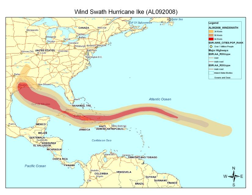
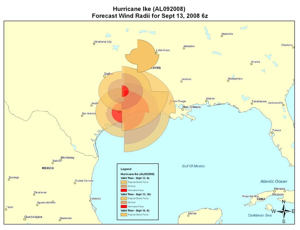
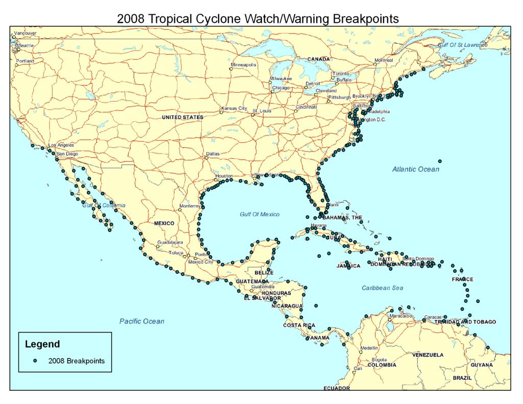
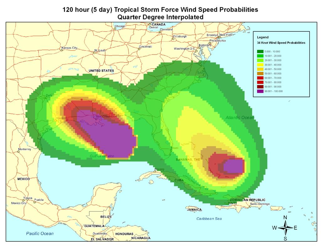
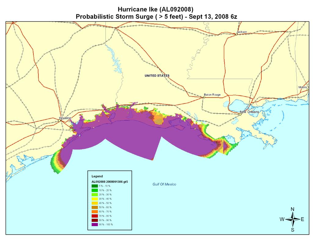
24 GIS Products Forecast Cone/Track/Points/ Watches and Warnings Surface Wind Field Working Best Track Wind Swath Forecast Wind Radii Breakpoints Wind Speed Probability Probabilistic Storm Surge
25 Other NHC Tropical Cyclone ABNT30 KNHC TWSAT MONTHLY TROPICAL WEATHER SUMMARY NWS TPC/NATIONAL HURRICANE CENTER MIAMI FL 800 AM EDT FRI OCT FOR THE NORTH ATLANTIC...CARIBBEAN SEA AND THE GULF OF MEXICO... EIGHT TROPICAL STORMS FORMED IN THE ATLANTIC BASIN DURING THE MONTH OF SEPTEMBER. THREE OF THESE STORMS...IGOR...JULIA...AND KARL... BECAME MAJOR HURRICANES...AND LISA REACHED HURRICANE STATUS. THESE NUMBERS ARE WELL ABOVE THE LONG-TERM ( ) AVERAGES OF 4 TROPICAL STORMS...2 HURRICANES...AND ABOUT 1 MAJOR HURRICANE FOR THE MONTH OF SEPTEMBER. ALSO...THE FORMATION OF EIGHT NAMED STORMS TIES 2002 FOR THE RECORD NUMBER OF NAMED STORMS FORMING IN THE MONTH OF SEPTEMBER. IN TERMS OF ACCUMULATED CYCLONE ENERGY... ACE...WHICH MEASURES THE COMBINED STRENGTH AND DURATION OF TROPICAL STORMS AND HURRICANES...TROPICAL CYCLONE ACTIVITY IN SEPTEMBER WAS ABOUT 78 PERCENT ABOVE AVERAGE. SO FAR THIS SEASON...OVERALL TROPICAL CYCLONE ACTIVITY TO DATE IS ABOUT 53 PERCENT ABOVE THE LONG-TERM MEDIAN. REPORTS ON INDIVIDUAL CYCLONES...WHEN COMPLETED...ARE AT THE WEB SITE OF THE NATIONAL HURRICANE CENTER...USE LOWER-CASE LETTERS... SUMMARY TABLE NAME DATES MAX WIND (MPH) H ALEX 25 JUN-2 JUL 105 TD TWO 7-8 JUL 35 TS BONNIE JUL 40 TS COLIN 2-8 AUG 60 TD FIVE AUG 35 MH DANIELLE AUG 135 MH EARL 25 AUG-5 SEP 145 TS FIONA 30 AUG-4 SEP 60 TS GASTON 1-2 SEP 40 TS HERMINE 6-8 SEP 65 MH IGOR 8-21 SEP 155 MH JULIA SEP 135 MH KARL SEP 120 H LISA SEP 80 Related Products Tropical Weather Summary Issued on the first of each month from July-Dec Summarizes tropical cyclones that occurred during the previous month Provides preliminary statistics of the season thus far

26 Other NHC Tropical Cyclone Related Products Preliminary Track Maps Posted to NHC website around the 1 st of each month Provides preliminary tracks of the season s tropical cyclones to date Operational track & intensities shown until final besttrack issued


27 Other NHC Tropical Cyclone Related Products Tropical Cyclone Reports Reports are completed weeks to a couple of months after each storm Posted to NHC website Provide final track, intensity, and size information Discusses damage and casualties, and provides forecast critique
28 Questions/Comments?
Overview of Current Tropical Cyclone Products Generated by NWS
 Overview of Current Tropical Cyclone Products Generated by NWS Todd B. Kimberlain National Hurricane Center HFIP Ensembles Workshop Boulder, Colorado 20 April 2010 National Weather Service hurricane forecast
What s s New for 2009
 What s s New for 2009 Graphical Tropical Weather Outlook becomes operational Special Tropical Disturbance Statement replaced with Special Tropical Weather Outlook Tropical Cyclone Wind Field Graphic becomes
A Look Back at the 2012 Hurricane Season and a Look Ahead to 2013 & Beyond. Daniel Brown National Hurricane Center Miami, Florida 24 April 2013
 A Look Back at the 2012 Hurricane Season and a Look Ahead to 2013 & Beyond Daniel Brown National Hurricane Center Miami, Florida 24 April 2013 2012 Atlantic Verification Good News- Lots of Accuracy Records
Tropical Update. 5 PM EDT Tuesday, September 5, 2017 Hurricane Irma, Tropical Storm Jose, and Tropical Depression Thirteen
 Tropical Update 5 PM EDT Tuesday, September 5, 2017 Hurricane Irma, Tropical Storm Jose, and Tropical Depression Thirteen This update is intended for government and emergency response officials, and is
Tropical Update. 5 PM EDT Sunday, September 10, 2017 Hurricane Irma, Hurricane Jose, Tropical Wave (60%)
") Tropical Update 5 PM EDT Sunday, September 10, 2017 Hurricane Irma, Hurricane Jose, Tropical Wave (60%) This update is intended for government and emergency response officials, and is provided for informational
Tropical Update 5 PM EDT Sunday, September 10, 2017 Hurricane Irma, Hurricane Jose, Tropical Wave (60%) This update is intended for government and emergency response officials, and is provided for informational
RSMC-Miami Update Daniel Brown Warning Coordination Meteorologist
 RSMC-Miami Update 2016 Daniel Brown Warning Coordination Meteorologist L-0324 Emergency Management Hurricane Preparedness Training Course Funding provided by FEMA s National Hurricane Program - partnership
An upper to mid level circulation (Low) in the NW Caribbean is
 in the NW Caribbean is") WEEKLY WEATHER OUTLOOK BELIZE, CENTRAL AMERICA PERIOD: Monday-Monday, Oct. 1 October 8, 2012 DATE ISSUED: Monday, Oct 1, 2012 6:00 am RFrutos EcoSolutions & Services SYNOPSIS: An upper to mid level circulation
WEEKLY WEATHER OUTLOOK BELIZE, CENTRAL AMERICA PERIOD: Monday-Monday, Oct. 1 October 8, 2012 DATE ISSUED: Monday, Oct 1, 2012 6:00 am RFrutos EcoSolutions & Services SYNOPSIS: An upper to mid level circulation
There is a Storm. What s the Info? National Weather Service Tropical Cyclone Products
 NHC Forecasts There is a Storm. What s the Info? National Weather Service Tropical Cyclone Products National Weather Service Tropical Cyclone Products NHC provides the big picture that complements and
Tropical Update. 5 PM EDT Sunday, October 7, 2018 Tropical Storm Michael, Tropical Storm Leslie, & Invest 92L (30%)
") Tropical Update 5 PM EDT Sunday, October 7, 2018 Tropical Storm Michael, Tropical Storm Leslie, & Invest 92L (30%) This update is intended for government and emergency response officials, and is provided
Tropical Update 5 PM EDT Sunday, October 7, 2018 Tropical Storm Michael, Tropical Storm Leslie, & Invest 92L (30%) This update is intended for government and emergency response officials, and is provided
Tropical Update. 5 AM EDT Tuesday, September 12, 2017 Post-Tropical Cyclone Irma, Hurricane Jose, & Tropical Wave (10%)
") Tropical Update 5 AM EDT Tuesday, September 12, 2017 Post-Tropical Cyclone Irma, Hurricane Jose, & Tropical Wave (10%) This update is intended for government and emergency response officials, and is provided
Tropical Update 5 AM EDT Tuesday, September 12, 2017 Post-Tropical Cyclone Irma, Hurricane Jose, & Tropical Wave (10%) This update is intended for government and emergency response officials, and is provided
WEEKLY WEATHER OUTLOOK BELIZE, CENTRAL AMERICA
 WEEKLY WEATHER OUTLOOK BELIZE, CENTRAL AMERICA PERIOD: Sunday, July 1 until Monday, July 9, 2012 DATE ISSUED: Sunday, July 1, 2012 3:00 pm RFrutos EcoSolutions & Services SYNOPSIS: The features of interest
Tropical Update. 11 AM EDT Tuesday, October 9, 2018 Hurricane Michael, Tropical Storm Leslie, Tropical Storm Nadine
 Tropical Update 11 AM EDT Tuesday, October 9, 2018 Hurricane Michael, Tropical Storm Leslie, Tropical Storm Nadine This update is intended for government and emergency response officials, and is provided
Tropical Update. 5 AM EDT Wednesday, September 6, 2017 Hurricane Irma, Tropical Storm Jose, and Tropical Storm Katia
 Tropical Update 5 AM EDT Wednesday, September 6, 2017 Hurricane Irma, Tropical Storm Jose, and Tropical Storm Katia This update is intended for government and emergency response officials, and is provided
A surge in the easterlies and an influx of moisture and instability is inducing
 WEEKLY WEATHER OUTLOOK BELIZE, CENTRAL AMERICA PERIOD: Monday-Monday, July 16-23, 2012 DATE ISSUED: Monday, July 16, 2012 6:00 am RFrutos EcoSolutions & Services SYNOPSIS: A number of features of interest
Wind Speed Probability Products. Daniel Brown and Michael Brennan National Hurricane Center
 Wind Speed Probability Products Daniel Brown and Michael Brennan National Hurricane Center 2017 WMO Course 7 March 2017 Wind Speed Probabilities A Tool to Deal with Uncertainty Hurricane Irene Advisory
Wind Speed Probability Products
 Wind Speed Probability Products Daniel Brown National Hurricane Center 2018 WMO Course 6 March 2018 Wind Speed Probabilities A Tool to Deal with Uncertainty Hurricane Irene Advisory Number 12 Issued 5:00
Tropical Update. 5 AM EDT Monday, October 8, 2018 Tropical Storm Michael, Tropical Storm Leslie, Invest 92L (10%) & African Tropical Wave (50%)
 & African Tropical Wave (50%)") Tropical Update 5 AM EDT Monday, October 8, 2018 Tropical Storm Michael, Tropical Storm Leslie, Invest 92L (10%) & African Tropical Wave (50%) This update is intended for government and emergency response
Tropical Update 5 AM EDT Monday, October 8, 2018 Tropical Storm Michael, Tropical Storm Leslie, Invest 92L (10%) & African Tropical Wave (50%) This update is intended for government and emergency response
Storm Summary for Hurricane Jose
 Storm Summary for Hurricane Jose Tuesday, September 19, 2017 at 11 AM EDT (Output from Hurrevac, based on National Hurricane Center Forecast Advisory #57) Jose is currently a Category 1 hurricane on the
WELCOME TO THE 2018 RA-IV WORKSHOP ON HURRICANE FORECASTING AND WARNING
 WELCOME TO THE 2018 RA-IV WORKSHOP ON HURRICANE FORECASTING AND WARNING Richard J. Pasch and Daniel P. Brown Senior Hurricane Specialists National Hurricane Center ORIENTATION Use of PCs NHC Facility Workshop
Tropical Update. 5 AM EDT Thursday, September 7, 2017 Hurricane Irma, Hurricane Jose, and Hurricane Katia
 Tropical Update 5 AM EDT Thursday, September 7, 2017 Hurricane Irma, Hurricane Jose, and Hurricane Katia This update is intended for government and emergency response officials, and is provided for informational
Tropical Update. 1 PM EDT Monday, May 21, 2018 Caribbean Disturbance (20%)
") Tropical Update 1 PM EDT Monday, May 21, 2018 Caribbean Disturbance (20%) This update is intended for government and emergency response officials, and is provided for informational and situational awareness
Tropical Update 1 PM EDT Monday, May 21, 2018 Caribbean Disturbance (20%) This update is intended for government and emergency response officials, and is provided for informational and situational awareness
Tropical Update. 11 AM EDT Wednesday, October 10, 2018 Hurricane Michael, Hurricane Leslie & Tropical Storm Nadine, Caribbean Low (40%)
") Tropical Update 11 AM EDT Wednesday, October 10, 2018 Hurricane Michael, Hurricane Leslie & Tropical Storm Nadine, Caribbean Low (40%) This update is intended for government and emergency response officials,
Tropical Update 11 AM EDT Wednesday, October 10, 2018 Hurricane Michael, Hurricane Leslie & Tropical Storm Nadine, Caribbean Low (40%) This update is intended for government and emergency response officials,
There is a Storm. What s the Info? National Weather Service Tropical Cyclone Products
 NHC Forecasts There is a Storm. What s the Info? National Weather Service Tropical Cyclone Products National Weather Service Tropical Cyclone Products NHC provides the big picture that complements and
WEEKLY WEATHER OUTLOOK BELIZE, CENTRAL AMERICA
 WEEKLY WEATHER OUTLOOK BELIZE, CENTRAL AMERICA PERIOD: Sunday, June 17 until Monday, June 25, 2012 DATE ISSUED: Sunday, June 17, 2012; 3:00 pm RFrutos EcoSolutions & Services SYNOPSIS: An upper level trough
Storm Summary for Hurricane Joaquin
 Storm Summary for Hurricane Joaquin Wednesday, September 30, 2015 at 5 PM EDT (Output from Hurrevac, based on National Hurricane Center Forecast Advisory #12) Joaquin is currently a Category 1 hurricane
Tropical Update. 5 PM EDT Thursday, September 7, 2017 Hurricane Irma, Hurricane Jose, and Hurricane Katia
 Tropical Update 5 PM EDT Thursday, September 7, 2017 Hurricane Irma, Hurricane Jose, and Hurricane Katia This update is intended for government and emergency response officials, and is provided for informational
Atlantic Basin Satellite Image
 Tropical Update 11 AM EDT Friday, September 7, 2018 Tropical Depression Gordon, Tropical Storm Florence, Potential Tropical Cyclone #8 (90%), Invest 92L (90%) This update is intended for government and
WEEKEND WEATHER OUTLOOK BELIZE, CENTRAL AMERICA
 WEEKEND WEATHER OUTLOOK BELIZE, CENTRAL AMERICA PERIOD: Friday, July 6 until Monday, July 9, 2012 DATE ISSUED: Friday, July 6, 2012; 9:00 am RFrutos SYNOPSIS: An active tropical wave (TW) just west of
Tropical Update. 12 PM EDT Friday, October 7, 2016 Hurricane Matthew & Tropical Storm Nicole
 Tropical Update 12 PM EDT Friday, October 7, 2016 Hurricane Matthew & Tropical Storm Nicole This update is intended for government and emergency response officials, and is provided for informational and
Saturday, October 6, :30 a.m. EDT
 Saturday, October 6, 2018 8:30 a.m. EDT Significant Activity Oct 5-6 Significant Events: None Tropical Activity: Atlantic Tropical Storm Leslie; Disturbance 1 (High: 90%) Eastern Pacific Hurricane Sergio
WEEKEND WEATHER OUTLOOK BELIZE, CENTRAL AMERICA
 WEEKEND WEATHER OUTLOOK BELIZE, CENTRAL AMERICA PERIOD: Friday, July 13 until Monday, July 16, 2012 DATE ISSUED: Friday, June 13, 2012, 9:00 am RFrutos SYNOPSIS: A weak pressure gradient over the NW Caribbean
Tropical Update. 5 PM EDT Thursday, August 27, 2015 Tropical Storm Erika
 Tropical Update 5 PM EDT Thursday, August 27, 2015 Tropical Storm Erika This update is intended for government and emergency response officials, and is provided for informational and situational awareness
WEATHER SYSTEMS IMPACTING THE CAYMAN ISLANDS Prepared by the staff of the Cayman Islands National Weather Service
 WEATHER SYSTEMS IMPACTING THE CAYMAN ISLANDS 2008 Prepared by the staff of the Cayman Islands National Weather Service TROPICAL STORM DOLLY Formed 194 miles west of Grand Cayman July 19 th. The tropical
HURRICANE IRMA. 12 PM ET Saturday, September Prepared by: Kyle Thiem / Sid King.
 HURRICANE IRMA 12 PM ET Saturday, September 9 2017 Prepared by: Kyle Thiem / Sid King www.weather.gov/atlanta/briefings @NWSAtlanta www.weather.gov/atlanta Situation Overview 11:00 AM EDT Sat Sep 9 Location:
Tropical Update 11 AM EDT Thursday, September 6, 2018 Tropical Depression Gordon, Hurricane Florence, Invest 92L (90%) & African Tropical Wave (50%)
 & African Tropical Wave (50%)") Tropical Update 11 AM EDT Thursday, September 6, 2018 Tropical Depression Gordon, Hurricane Florence, Invest 92L (90%) & African Tropical Wave (50%) This update is intended for government and emergency
Tropical Update 11 AM EDT Thursday, September 6, 2018 Tropical Depression Gordon, Hurricane Florence, Invest 92L (90%) & African Tropical Wave (50%) This update is intended for government and emergency
ovember 2008 Antigua and Barbuda Meteorological Service
 ovember 2008 Antigua and Barbuda Meteorological Service The Atlantic Hurricane Season Summary 2008 Special Focus on Antigua and Barbuda The Season in Brief Sixteen (16) named storms formed in the Atlantic
HVX-HURREVAC (Beta) Webinar Series
 Webinar Series") HVX-HURREVAC (Beta) Webinar Series Day 1 - An introduction to HURREVAC and the new web-based HVX platform 2018 HVX-HURREVAC Webinar Series 1. Intro to HURREVAC and General Overview of the Program (August
HVX-HURREVAC (Beta) Webinar Series Day 1 - An introduction to HURREVAC and the new web-based HVX platform 2018 HVX-HURREVAC Webinar Series 1. Intro to HURREVAC and General Overview of the Program (August
GC Briefing. Weather Sentinel Hurricane Florence. Status at 5 PM EDT (21 UTC) Today (NHC) Discussion. September 13, 2018
 Today (NHC) Discussion. September 13, 2018") GC Briefing September 13, 2018 Weather Sentinel Hurricane Florence Tropical storm conditions have been reported for areas of North Carolina and will continue to spread inland to the west and south. Hurricane
GC Briefing September 13, 2018 Weather Sentinel Hurricane Florence Tropical storm conditions have been reported for areas of North Carolina and will continue to spread inland to the west and south. Hurricane
& ~ Hurricane Season Review ~
 & ~ Hurricane Season Review ~ St. Maarten experienced drought conditions in 2016 with no severe weather events. All Photos compliments Paul G. Ellinger Meteorological Department St. Maarten Airport Rd.
Major Hurricane Matthew Briefing Situation Overview
 Major Hurricane Matthew Briefing Situation Overview At 5 p.m. Tuesday, Category 4 Hurricane Matthew was about 860 miles South-Southeast of Mayport, Florida, moving north around 10 mph. Maximum sustained
Hurricane Matthew Page 1 Location Forecast Analysis Summary Report - Advanced Wind Estimation On
 Page 1 Current NHC Forecast Predictions Maximum Sustained Winds / Storm Category: 138 MPH / Category 4 Forward motion: 9 mph towards the North Hurricane Force winds extend from the center: 46 miles Tropical
Outlook 2008 Atlantic Hurricane Season. Kevin Lipton, Ingrid Amberger National Weather Service Albany, New York
 Outlook 2008 Atlantic Hurricane Season Kevin Lipton, Ingrid Amberger National Weather Service Albany, New York Summary 2007 Hurricane Season Two hurricanes made landfall in the Atlantic Basin at category-5
GC Briefing. Weather Sentinel Tropical Storm Michael. Status at 8 AM EDT (12 UTC) Today (NHC) Discussion. October 11, 2018
 Today (NHC) Discussion. October 11, 2018") GC Briefing Weather Sentinel Tropical Storm Michael October 11, 2018 After making landfall as a high-end category-4 hurricane on the Florida Panhandle, Michael weakened to tropical storm status early this
GC Briefing Weather Sentinel Tropical Storm Michael October 11, 2018 After making landfall as a high-end category-4 hurricane on the Florida Panhandle, Michael weakened to tropical storm status early this
HURREVAC Webinar Series Day 1 Intro to HURREVAC and General Overview of the Program. National Hurricane Program Training Course
 HURREVAC Webinar Series Day 1 Intro to HURREVAC and General Overview of the Program 2017 HURREVAC Webinar Series 1. Intro to HURREVAC and General Overview of the Program (August 7 th or 14 th ) 2. Evacuation
Tropical Storm Colin Briefing Last Briefing on this System
 Tropical Storm Colin Briefing Last Briefing on this System NWS WFO Jacksonville, Florida Tuesday, June 07, 2016 6:00 a.m. EDT Tropical Storm Colin s Impacts SE Georgia & North Florida Local Watches & Warnings:
ERTH 365 Homework #2: Hurricane Harvey. 100 points
 ERTH 365 Homework #2: Hurricane Harvey 100 points Due by 6pm, Tuesday 30 October 2018, ELECTRONIC SUBMISSON BY EMAIL ONLY BY 6PM (send to klevey@sfsu.edu) (acceptable formats: MS Word, Google Doc, plain
Tropical Update 6 AM EDT Friday, October 7, 2016 Hurricane Matthew & Hurricane Nicole
 Tropical Update 6 AM EDT Friday, October 7, 2016 Hurricane Matthew & Hurricane Nicole This update is intended for government and emergency response officials, and is provided for informational and situational
Monday, October 8, :30 a.m. EDT
 Monday, October 8, 2018 8:30 a.m. EDT Significant Activity Oct 7-8 Significant Events: Tropical Storm Michael Preparation Tropical Activity: Atlantic Tropical Storm Leslie; Tropical Storm Michael; Disturbance
NWS HURRICANES June 3, 2015
 NWS HURRICANES June 3, 2015 Hurricane Season June 1 November 30 2 What s the concern? All tropical systems passing within 125nm of central Maryland since 1950 Mid-Atlantic Hurricanes Greatest Risk: August
Tropical Storm Harvey: SE Texas Impacts
 Tropical Storm Harvey: SE Texas Impacts 10 AM CDT UPDATE Thursday, August 24, 2017 Prepared by: Dan Reilly, Brian Kyle PLEASE MUTE YOUR LINES AND DON T PUT ON HOLD! Situation Overview Tropical Storm Harvey
August Forecast Update for Atlantic Hurricane Activity in 2015
 August Forecast Update for Atlantic Hurricane Activity in 2015 Issued: 5 th August 2015 by Professor Mark Saunders and Dr Adam Lea Dept. of Space and Climate Physics, UCL (University College London), UK
August Forecast Update for Atlantic Hurricane Activity in 2016
 August Forecast Update for Atlantic Hurricane Activity in 2016 Issued: 5 th August 2016 by Professor Mark Saunders and Dr Adam Lea Dept. of Space and Climate Physics, UCL (University College London), UK
TROPICAL STORM HARVEY BRIEFING
 TROPICAL STORM HARVEY BRIEFING 10:00 AM CDT Sunday, August 27, 2017 Prepared by: NWS LIX NWSNewOrleans www.weather.gov/neworleans Situation Overview New Information Tropical Storm Winds 40mph Immediate
August Forecast Update for Atlantic Hurricane Activity in 2012
 August Forecast Update for Atlantic Hurricane Activity in 2012 Issued: 6 th August 2012 by Professor Mark Saunders and Dr Adam Lea Dept. of Space and Climate Physics, UCL (University College London), UK
ARUBA CLIMATOLOGICAL SUMMARY 2017 PRECIPITATION
 ARUBA CLIMATOLOGICAL SUMMARY 2017 PRECIPITATION The total amount of rainfall recorded at Reina Beatrix International Airport for the year 2017 was 391.0 mm. This is 17.1 % below normal ( Figure 1 ). During
Daily Operations Briefing Monday, September 19, :30 a.m. EDT
 Daily Operations Briefing Monday, September 19, 2016 8:30 a.m. EDT Significant Activity - Sept 19-20 Significant Events: None Tropical Activity: Atlantic Tropical Storm Karl, Disturbance 1: High (80%)
Friday, September 7, :30 a.m. EDT
 Friday, September 7, 2018 8:30 a.m. EDT Tropical Depression Gordon - Final Situation (Advisory #20 as of 5:00 a.m. EDT) Located 30 miles S of Little Rock, AR Moving N at 5 mph; this motion expected to
Weekend Outlook Belize, Central America Valid for: Friday until Monday, May 25-28, 2012
 Weekend Outlook Belize, Central America Valid for: Friday until Monday, May 25-28, 2012 RFrutos Synopsis: Conditions this past week improved by Wednesday as a surface low and trough producing the showery
Daily Operations Briefing Sunday, June 7, :30 a.m. EDT
 Daily Operations Briefing Sunday, June 7, 2015 8:30 a.m. EDT Significant Activity: June 6-7 Significant Events: None Tropical Activity: Atlantic Tropical cyclone activity not expected during the next 24
Case Studies in Communication Challenges: Hurricane Sandy
 Case Studies in Communication Challenges: Hurricane Sandy International Workshop on Tropical Cyclones Jeju Island, South Korea Chris Landsea, National Hurricane Center, RSMC Miami Major Hurricane Sandy
Summary of 2004 Atlantic Tropical Cyclone Season and Verification of Authors Seasonal Forecasts
 Summary of 2004 Atlantic Tropical Cyclone Season and Verification of Authors Seasonal Forecasts Issued: 31st January 2005 by Drs Mark Saunders and Adam Lea Benfield Hazard Research Centre, UCL (University
Careful, Cyclones Can Blow You Away!
 Title: Careful, Cyclones Can Blow You Away! (Meteorology) Grade(s): 6-8 Introduction: Most people associate twisters with tornadoes, but in fact tropical twisters come from hurricanes. Hurricanes are what
Hurricane Irma Page 1 HURRTRAK RM/Pro 2017 Summary Report for Tampa, FL 09/10/ EDT, Adv. # 46
 Hurricane Irma Page 1 Description of impact to Tampa, FL, Tampa, FL, is expected to receive a major impact from Hurricane Irma. The forecast maximum wind for this location has increased since the last
Daily Operations Briefing Monday, November 4, :30 a.m. EST
 Daily Operations Briefing Monday, November 4, 2013 8:30 a.m. EST 1 Significant Activity: Nov 2 4 Significant Events: None Tropical Activity: Atlantic Area 1 (10%) Eastern Pacific Tropical Depression Sonia
IWT Scenario 2 Integrated Warning Team Workshop National Weather Service Albany, NY October 31, 2014
 IWT Scenario 2 Integrated Warning Team Workshop National Weather Service Albany, NY October 31, 2014 09 10 11 12 13 Scenario 2 Timeline December 9-13 Tue Wed Thu Fri Sat Tue, Dec. 9 @ 5 am 2014 2014 2014
Storm Surge Forecast with Shifting Forecast Tracks
 Storm Surge Forecast with Shifting Forecast Tracks Storm Surge Findings in the Florida Keys Jon Rizzo Warning Coordination Meteorologist National Weather Service Florida Keys Florida Keys Life History
Standardizing hurricane size descriptors for broadcast to the public
 Standardizing hurricane size descriptors for broadcast to the public Lori Drake, Hurricane Roadmap Project AMS 40th Conference on Broadcast Meteorology August 22-24, 2012, Boston, MA, Operational Forecasting
Friday, September 28, :30 a.m. EDT
 Friday, September 28, 2018 8:30 a.m. EDT Significant Activity Sep 26-27 Significant Events: Hurricane Florence Response / Recovery Tropical Activity: Atlantic Tropical Storm Kirk; Disturbance 1: High (90%)
Hurricane Charley: A Retrospective 2014 Florida Governor s Hurricane Conference
 Hurricane Charley: A Retrospective 2014 Florida Governor s Hurricane Conference 2004 Hurricane Season: Storm Tracks Satellite Images of 2004 Hurricanes Charley Frances Ivan Jeanne Three Hurricanes in Polk
Saturday, September 1, :30 a.m. EDT
 Saturday, September 1, 2018 8:30 a.m. EDT Significant Activity Aug 31 Sep 1 Significant Events: None Tropical Activity: Atlantic Tropical Storm Florence; Disturbance 1: Medium (40%) Eastern Pacific Hurricane
Canadian Hurricane Center: How NHC Products are used to issue Warnings and Communicate Hazards
 Canadian Hurricane Center: How NHC Products are used to issue Warnings and Communicate Hazards Bob Robichaud Warning Preparedness Meteorologist Canadian Hurricane Centre Contents Brief background on the
Daily Operations Briefing Wednesday, October 16, :30 a.m. EDT
 Daily Operations Briefing Wednesday, October 16, 2013 8:30 a.m. EDT 1 Significant Activity: Oct 15 16 Significant Events: None Tropical Activity: Atlantic Area 1 (10%) Eastern Pacific Tropical Depression
National Situation Report As of 3:00 a.m. EDT, Thursday, September 21, 2017 Table of Contents Current Operations Monitoring Recovery
 25k Overview National Situation Report As of 3:00 a.m. EDT, Thursday, September 21, 2017 Table of Contents Current Operations Monitoring Recovery FEMA Headquarters Status FEMA Region Status NRCC Level
Tropical Storm Ana. Created 6:00 AM Sun May 10, 2015 John Cole Warning Coordination Meteorologist
 Tropical Storm Ana Threat Assessment for Eastern North Carolina Created 6:00 AM Sun May 10, 2015 John Cole Warning Coordination Meteorologist John.cole@noaa.gov National Weather Service Newport/Morehead
Daily Operations Briefing. Wednesday, August 23, :30 a.m. EDT
 Daily Operations Briefing Wednesday, August 23, 2017 8:30 a.m. EDT Significant Activity August 22-23 Significant Events: Tropical Weather Threat Gulf Coast Tropical Activity: Atlantic Disturbance 1 High
TROPICAL DEPRESSION HARVEY BRIEFING
 TROPICAL DEPRESSION HARVEY BRIEFING 10:15 PM CDT Wednesday, August 23, 2017 Prepared by: Lara Beal NWSCorpus www.weather.gov/corpuschristi Situation Overview No changes to Watches. Hurricane Watch remains
Continuity in the Face of Hurricanes: What Every Business Needs To Know. Cameron Self, Tropical Meteorologist. StormGeo
 Continuity in the Face of Hurricanes: What Every Business Needs To Know Cameron Self, Tropical Meteorologist. StormGeo A Hurricane is a Big Heat Engine Forming over warm tropical waters, wind speeds range
Hurricane Matthew. National Weather Service Wilmington NC. Steven Pfaff, WCM.
 Hurricane Matthew Threat Assessment for northeast South Carolina & southeast North Carolina National Weather Service Wilmington NC 730 AM EDT Tuesday October 4, 2016 Steven Pfaff, WCM Steven.Pfaff@noaa.gov
Daily Operations Briefing. Tuesday, October 24, :30 a.m. EDT
 Daily Operations Briefing Tuesday, October 24, 2017 8:30 a.m. EDT Significant Activity Oct 23-24 Significant Events: Response and recovery Tropical Cyclones Harvey, Irma, Maria Tropical Activity: Atlantic
Tropical Weather Briefing
 Tropical Weather Briefing August 28, 2012 700 AM CDT National Weather Service Weather Forecast Office Slidell, LA Current Satellite Tropical Storm Isaac Watches/Warnings Tropical Storm Isaac Track Guidance
Frank Revitte National Weather Service. Weather Forecast Office New Orleans/Baton Rouge
 Frank Revitte National Weather Service Weather Forecast Office New Orleans/Baton Rouge Above normal activity 17 Total Named Storms 7 Tropical Storms 4 Hurricanes 6 Major Hurricanes Not the most active,
April Forecast Update for Atlantic Hurricane Activity in 2016
 April Forecast Update for Atlantic Hurricane Activity in 2016 Issued: 5 th April 2016 by Professor Mark Saunders and Dr Adam Lea Dept. of Space and Climate Physics, UCL (University College London), UK
Hurricane Irma Page 1 HURRTRAK RM/Pro 2017 Summary Report for Tampa, FL 09/09/ EDT, Adv. # 43
 Hurricane Irma Page 1 Description of impact to Tampa, FL, Tampa, FL, is expected to receive a major impact from Hurricane Irma. The forecast maximum wind for this location has decreased since the last
Homework 2: Hurricane Katrina. Part 1. Hurricane Katrina, August 28, 2005 Satellite Imagery
 Metr 302 Homework 2 Fall 2014 Meteorology 302 Fall 2014 Name Homework 2: Hurricane Katrina 100 points total Distributed Thursday 30 October 2014; Due Thursday 13 November 2014 Answer all questions in complete
Ch. 11: Hurricanes. Be able to. Define what hurricane is. Identify the life and death of a hurricane. Identify the ways we track hurricanes.
 Ch. 11: Hurricanes Be able to Define what hurricane is. Identify the life and death of a hurricane. Identify the ways we track hurricanes. What are Hurricanes? Smaller than mid-latitude cyclones. Don t
2006 ATLANTIC HURRICANE SUMMARY. Weather Research Center Houston, Texas
 2006 ATLANTIC HURRICANE SUMMARY Weather Research Center Houston, Texas Weather Research Center 5104 Caroline Houston, Texas 77004 Phone: 713-529-3076 Fax: 713-528-3538 E-mail: wrc@wxresearch.org 2006 Atlantic
Daily Operations Briefing Tuesday, November 5, :30 a.m. EST
 Daily Operations Briefing Tuesday, November 5, 2013 8:30 a.m. EST 1 Significant Activity: Nov 4 5 Significant Events: None Tropical Activity: Atlantic No tropical cyclone activity expected next 48 hours
July Forecast Update for Atlantic Hurricane Activity in 2016
 July Forecast Update for Atlantic Hurricane Activity in 2016 Issued: 5 th July 2016 by Professor Mark Saunders and Dr Adam Lea Dept. of Space and Climate Physics, UCL (University College London), UK Forecast
Wednesday, June 13, :30 a.m. EDT
 Wednesday, June 13, 2018 8:30 a.m. EDT Significant Activity June 12-13 Significant Events: None Tropical Activity: Atlantic Disturbance 1: Low (20%) Eastern Pacific Tropical Storm Bud; Disturbance 1: Low
Daily Operations Briefing Saturday, October 1, :30 a.m. EDT
 Daily Operations Briefing Saturday, October 1, 2016 8:30 a.m. EDT Significant Activity Sept 30-Oct 1 Significant Events: None Tropical Activity: Atlantic Hurricane Matthew (CAT4); Disturbance 1 Low (10%)
NHC Ocean Vector Winds Update
 NHC Ocean Vector Winds Update Michael J. Brennan NOAA/NWS/NCEP National Hurricane Center International Ocean Vector Winds Science Team Meeting Portland, Oregon, 20 May 2015 Current Status NHC is currently
11/19/14. Chapter 11: Hurricanes. The Atmosphere: An Introduction to Meteorology, 12 th. Lutgens Tarbuck
 Chapter 11: Hurricanes The Atmosphere: An Introduction to Meteorology, 12 th Lutgens Tarbuck Lectures by: Heather Gallacher, Cleveland State University! Hurricanes: " Hurricanes are intense centers of
Lessons Learned from Hurricane Harvey and Irma
 EOL Visit to NSF 3 March 2016 Lessons Learned from Hurricane Harvey and Irma Wen-Chau Lee National Center for Atmospheric Research 23 November 2017 Outline: Meteorological elements of the active 2017 Atlantic
Daily Operations Briefing. Wednesday, September 17, :30 a.m. EDT
 Daily Operations Briefing Wednesday, September 17, 2014 8:30 a.m. EDT Significant Activity: Sep 16 17 Significant Events: CA & OR Wildfires Tropical Activity: Atlantic Hurricane Edouard (Cat 1); Disturbance
Friday, August 31, :30 a.m. EDT
 Friday, August 31, 2018 8:30 a.m. EDT Significant Activity Aug 30-31 Significant Events: Flooding Wisconsin Tropical Activity: Atlantic Potential Tropical Cyclone Six High (90%); Disturbance 1: Low (10%)
2017 Hurricane Season and Beyond
 2017 Hurricane Season and Beyond Ken Graham National Hurricane Center Building a Weather-Ready Nation Much of U.S. Coast Saw Tropical Wind Watches or Warnings 2017 Hurricane Season Facts and Figures 7th
The 2009 Hurricane Season Overview
 The 2009 Hurricane Season Overview Jae-Kyung Schemm Gerry Bell Climate Prediction Center NOAA/ NWS/ NCEP 1 Overview outline 1. Current status for the Atlantic, Eastern Pacific and Western Pacific basins
HURRICANE HARVEY COE Navigation BRIEFING
 HURRICANE HARVEY COE Navigation BRIEFING 10:00 AM CDT Friday, August 25, 2017 NWSNewOrleans www.weather.gov/neworleans Situation Overview New Information Harvey continues to strengthen Max sustained winds
Daily Operations Briefing. Wednesday, August 2, :30 a.m. EDT
 Daily Operations Briefing Wednesday, August 2, 2017 8:30 a.m. EDT Significant Activity August 1-2 Significant Events: None Tropical Activity: Atlantic Disturbance 1 Low (10%); Disturbance 2 Low (10%) Eastern
 Hazard Warnings GE 4150 Natural Hazards September 17, 2007 http://www.sdr.gov/ndis_rev_oct27.pdf Sorensen, J.H. (2000) Hazard warning systems: Review of 20 years of progress. Natural Hazards Review, May,