EVALUATION AND VERIFICATION OF PUBLIC WEATHER SERVICES. Pablo Santos Meteorologist In Charge National Weather Service Miami, FL
|
|
|
- Magdalene Chase
- 5 years ago
- Views:
Transcription
1 EVALUATION AND VERIFICATION OF PUBLIC WEATHER SERVICES Pablo Santos Meteorologist In Charge National Weather Service Miami, FL
2 WHAT IS THE MAIN DIFFERENCE BETWEEN A GOVERNMENT WEATHER SERVICE FORECAST AND A MEDIA FORECAST??? ACCOUNTABILITY!!!
3 HOW ARE FORECASTS USED?? HOW MEDIA FORECAST ARE USED: What Should I Wear Outside? Is It Going To Rain Today? HOW GOV T FORECAST ARE USED: Who Needs To Be Mobilized? What Areas Must Be Evacuated What Should I Tell The President/ Governor/Prime Minister, Etc
4 VERIFICATION GOALS: To Gage The Accuracy, Skill And Timeliness Of Warnings, Watches And Forecasts To Provide A Baseline To Assist In Setting Goals For Measuring Performance Identify Training Needs To Assist In Improvement Of Forecast And Warning Process & Products

5 Evaluation Begins By Establishing Performance Goals
6 REGARDLESS OF THE USER ANY FORECAST SHOULD BE EVALUATED IN 3 WAYS: Is It Timely And Accurate? Is It Understandable? Does It Meet The Users Needs? The First Goal Can Be Objectively Evaluated The Others Take Work!
7 OBJECTIVE VERIFICATION Public Forecasts & Warnings Aviation Forecasts Marine Forecasts & Warnings Fire Weather Forecasts Goal Is To Provide Effective Objective Verification Of All Forecast Parameters
8 PUBLIC FORECASTS Primary Forecast Elements Include: Maximum & Minimum Temperatures Probability Of Precipitation Secondary Elements Include: Sky Condition (Cloudy, Partly Cloudy, Etc.) Winds Precipitation Type (Liquid vs. Frozen, Etc.)
9 PUBLIC FORECASTS While All NWS Products Are Produced In Text Format Those Text Forecasts Are Derived From Gridded Forecasts Of Individual Forecast Parameter Fields

10 All Forecast Elements Found in Gridded, Or Graphical Forecasts Can Be Much More Useful In Depicting Changes On A Spatial Or Temporal Scale But It Makes Realistic Verification Much More Difficult!
? - Model Forecast Fields? - Data Assimilation Fields?")
11 HOW DO WE EFFECTIVELY VERIFY GRIDDED FIELDS? THE FIRST QUESTION THAT MUST BE ANSWERED IS WHAT ARE WE GOING TO VERIFY AGAINST??? - Actual Observations (Points)? - Model Forecast Fields? - Data Assimilation Fields? Any of these options have their own set of problems!

12 Maximum Temperature Verification Against Actual Point Observations
13 Verification Against Actual Point Observations Strengths: - Probably The Most Realistic Scheme Uses Data People Understand - Deals With Absolute Error Therefore Is Easiest To Use and Understand Limitations: - Does Not Really Measure Skill No Control To Measure Against - Tends To Be Biased In Favor Of Locations With Smaller Ranges Of Conditions - Often, The Point Location Where The Observation Is Taken Is Not Representative Of The Area Where The Population Lives!

14 Site A: Let s Look At This Bias Issue And What It Means In A Comparison Of Temperature Forecast Verification Data For Two Sites - 94% Of Temp Forecasts Have Errors Of Less Than 5 Degrees - Less Than 1% Of Forecasts Have Errors Of 10 Degrees Or More Site B: - 70% Of Temp Forecasts Have Errors Of Less Than 5 Degrees - 8% Of Forecasts Have Errors Of 10 Degrees Or More Are The Site A Forecasters Really That Much Better Than Those At Site B? Should We Fire The Forecasters At Site B???


15 First, Let s Make Sure That This Is Actually A Fair Comparison! Site A Is Actually Key West Site B Is Minneapolis Minneapolis Average Temp Difference Between Warmest/Coldest Month : 53 Degrees Average Temp Difference Between Warmest/Coldest Month: 14 Degrees Key West The Answer To Our Question: Nope Key West Simply Does Not Have As Active A Weather and Climate Regime as Minneapolis Therefore, Fewer and Smaller Weather Changes This Means That Using This Type Of Absolute Comparison For All Forecast Offices Does Not Provide A Realistic Evaluation Of Forecast Skill

16 Is It Representative? Consider Jacksonville, FL Official Observations Are Taken Here But Most Of The Population Lives Here!
17 Verification Against Model, or Numerical Forecast Fields Strengths: - Easier To Judge Actual Skill Since Both Model and Human Forecasts Are Compared Against A Common Parameter Actual Observations - Is Much More Effective At Providing A Realistic Evaluation Of Forecaster Performance Limitations: - In The Public s Eyes The Comparison Isn t Much Of A Factor - If A Temperature Forecast Is Off by 20 Degrees, It s Not Much Comfort To The Public To Know That The Model Missed It By 25 Degrees!
18 Let s Look At This Verification Scheme For The Two Sites We Used Previously Key West: - Recall That 94% Of Temp Forecasts For This Station Have Errors Of Less Than 5 Degrees But The Raw Model Forecasts Were Actually 0.1% Better! - In Addition The Model Guidance Had 10% Fewer Errors of More Than 5 Degrees Minneapolis: - While The Absolute Errors For This Location Were Greater Than Those For Key West They Actually Improved Overall Against The Model Forecasts by 2.3% - And They Had 4% Fewer Errors of More Than 5 Degrees!

19 No Matter What Method Is Chosen Effectively Verifying Forecasts Involving Dozens Of Fields Out To As Much As 7 Days At Time Scales As Small As One Hour While Ensuring Consistency With Surrounding Offices Is A Huge Challenge!!
20 PUBLIC FORECASTS Primary Forecast Elements Include: Maximum & Minimum Temperatures
21 MAX & MIN TEMPERATURE FORCASTS Verification Efforts Focus On The Actual Value They Don t, However, Take Into Account: What Time The Max Or Min Occurred How The Temperature Changed During The Course Of A Forecast Period.
22 MAX & MIN TEMPERATURE FORECASTS Consider A Forecast For The Next 12 Hours, Released At 6 Am Which States Or Depicts The Following: Today: Cloudy. High Of 70. Actual Conditions: High During The 12 Hours Was 70 And Cloudy Conditions Existed For Most Of The Day. Did This Forecast Verify?
23 MAX & MIN TEMPERATURE FORECASTS From A Verification Standpoint This Was An Accurate Forecast However While The Temp At 6 AM Was 70 A Cold Front Passed Through And The Temp Dropped To Below 50 By 8 AM And Then Spent The Rest Of The Day In The 40s. It s Highly Debatable, Therefore, That This Would Be Considered A Good Forecast By Users!
24 PUBLIC FORECASTS Primary Forecast Elements Include: Maximum & Minimum Temperatures Probability Of Precipitation
25 PROBABILITY OF PRECIPITATION FORECASTS Probably The Least Understood Forecast Parameter Used By The U.S. NWS. Originally Designed As A Product Of 2 Probabilities: Conditional Probability Areal Probability Ultimately meant to convey frequency of occurrence given present conditions.
26 PROBABILITY OF PRECIPITATION FORECASTS Today s Forecasts Are Verified Against Probabilities Derived From Model Output Statistics A More Objective But Very Different Approach. The Point Could Legitimately Be Made That We Are Comparing Apples And Oranges! Despite This The Main Verification Tool Used To Evaluate PoP Forecasts is Brier Score
27 Brier Score Measures Accuracy Of A Set Of Probability Assessments (but it says nothing about reliability): N = Number Of Forecasts, Ft = Probability That Was Forecast Ot = Actual Outcome (0 If No Rain, 1 If Rain Occurs)
28 Brier Score With Brier Score, The Lower Score = Higher Accuracy: - If you forecast 100% and rain occurs, (ft and ot = 1) BS=0= Perfect! - If you forecast 100% and no rain, (ft=1, ot=0), BS=1 Awful! - If you forecast 70% and rain occurs (ft=.7, ot=1) BS=.09 Pretty Good! - If you forecast 30% and rain occurs (ft=.3, ot=1) BS=.49 Not Too Good! Brier Score Rewards The Aggressive and Punishes Hedge Forecasts! - If you forecast 50%, your BS=.25 Whether or not rain occurs. - Since The NWS Performance Goal for PoP is,<.10, This is Bad. NOTE: Interestingly enough hedge forecasts are punished by Brier Score yet they might be reliable.
29 So Why Not Just Forecast Either High Or Low Probabilities? Public Perception Is The Big Problem! Consider This Forecast Scenario: A Fast Moving Cold Front Is Forecast To Move Through With A Solid But Narrow Band Of Precipitation. The Forecaster Is Sure It Will Rain So She Forecasts a PoP of 100%
30 Was It A Good Forecast? When The Front Passed Through, It Rained For 10 Minutes From 10:00 AM to 10:10 AM Dropping A Total Of.02 Inch. For Verification Purposes, This Would Be A Perfect Brier Score Of 0. But How Useful Was It? - How About The Afternoon Picnic That Was Cancelled Even Though The Afternoon Was Totally Dry! - Or Work Lost On Construction Which Cancelled Work For The Entire Day Even Though It Only Rained For 10 Minutes!
31 While Brier Score Is An Effective Statistical Tool For Evaluating Precipitation Forecasts It Really Doesn t Measure How Helpful The PoP Forecasts Are To The People That Use Them or how reliable they are!!
32 SEVERE LOCAL STORM PRODUCTS AND VERIFICATION IDEALLY, THESE PRODUCTS FOLLOW A LOGICAL TIME/SPATIAL PATTERN THREAT AREA AND TIME FRAMES BECOME SMALLER AS THE EVENT BECOMES MORE CERTAIN.
33 Storm Prediction Center Identifies Potential Severe Weather Threat Areas Time Frame: Out As Far As 8 Days

34 Storm Prediction Center and Local NWS Office Issue Watches Time Frame: Usually 8 Hours Or Less
35 Local NWS Offices Issue Storm Based Warnings : Time Frame: Usually 1 Hour Or Less
36 SEVERE WEATHER: WATCHES VS. WARNINGS Watches Indicate Conditions Are Favorable For Severe Weather Development Warnings Are Issued When Severe Conditions Are Imminent Or Occurring There Are Important Differences In How These Products Are Verified!
37 SEVERE WEATHER: WATCH VERIFICATION Watches Are Generally Issued For Large Geographical Areas Sometimes Thousands Of Square Miles A Severe Weather Event Anywhere In This Geographical Area Verifies The Entire Watch

38
39 SEVERE WEATHER VERIFICATION: COUNTY VS. STORM-BASED WARNINGS Warnings For Severe Thunderstorms Or Tornadoes Used To Be Issued On A County By County Basis. However Storms Do Not Respect Political Boundaries! A Single Storm Will Frequently Threaten Parts Of Several Counties. Warnings Are Now Issued As Polygons Based On Specific Storm Location & Motion Rather Than Political Entities. This Does Present Some Verification Challenges But Provides Much More Realistic Verification!

40 Storm Based Warning Example:
): Was The Event Warned For?")
) Lead Time Of The Event Individual Offices Are Responsible For")
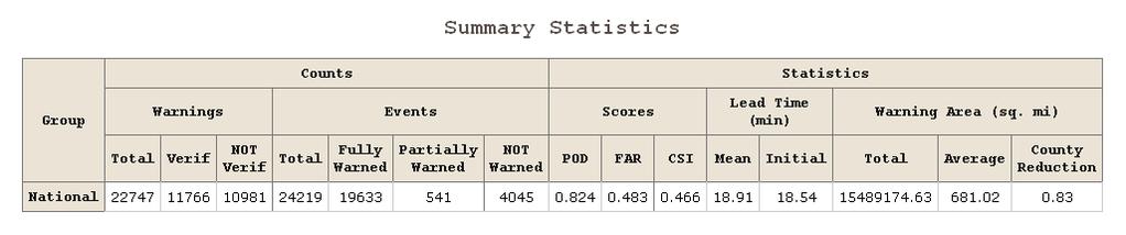
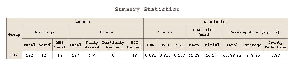
41 SEVERE WEATHER: WARNING VERIFICATION Warnings Are Verified Based On Four Primary Computed Parameters: Probability Of Detection (POD = A/(A+C)): Was The Event Warned For? False Alarm Ratio (FAR = B/(A+B)): Warning Was Issued, Did it Occur? Critical Success Index (CSI = A/(A+B+C)) Lead Time Of The Event Individual Offices Are Responsible For Gathering And Reporting Severe Weather Events In Their Area. This Data Is Published In Storm Data
42 SEVERE WEATHER: WARNING VERIFICATION For Verification Purposes, Severe Weather Includes: Thunderstorm Winds Of 50 Knots (58 Mph) Or Greater Hail Of 1.00 Diameter Or Greater Tornadoes (But Not Funnel Clouds) Occurrence Of Structural Wind Damage Which Implies The Existence Of Any Of The Above.
43 SEVERE WEATHER: WARNING VERIFICATION To Verify A Warning Event Must Occur Within The Valid Time And Area Of A Warning. This Is Subject To Some Complicated Limitations, However. For Example: The 10/15 Rule Severe Events Occurring Within 10 Miles Or 15 Minutes Of Each Other Are Considered Duplicates unless Winds Are 65 Mph Or More Or Hail Is 2 Or Greater Or It Is The Only Event Verifying A Warning. This Can Obviously Get Quite Confusing.
44
45 WARNING VERIFICATION: LONG FUSED EVENTS Longer Duration Events Such As Winter Storm Or High Wind Events Are Verified Differently. Main Criteria Is When And If An Event As Defined By The NWS Is First Observed In A Warned (Or Unwarned) Area Under Some Circumstances, (Both Long And Short Fused Events) A Warning Issued After The Beginning Of An Event Can Still Be A Verified Warning But With Zero Lead Time.

46 SUMMARY While No Verification Scheme Is Perfect, A Good One Will Do The Following: Realistically Measure Objective Data In The Way It Was Intended To Be Used Compares Forecast Data Sets To Others That Are Truly Forecasting The Same Thing Attempts to measure and/or establish usability. Can Be Used For Real Time Quality Control To Ensure Forecasts Are Useful To People, And Not Just A Set Of Numbers Can Truly Be Used To Identify Trends And Biases And Improve The Forecasts and Warnings

47 IMPROVING THE QUALITY OF PUBLIC WEATHER SERVICES Pablo Santos Meteorologist in Charge National Weather Service Miami, FL

48 Post-Disaster Service Assessments: A Key Part Of The Quality Improvement Process!

49 THREE IMMEDIATE POST-EVENT QUESTIONS: What Went Right? What Went Wrong? How Can We Improve? Answering These 3 Questions Is The Primary Goal Of A Service Assessment!
50 WHAT A SERVICE ASSESSMENT IS : A Learning Tool For Future Events A Way To Identify Best Practices A Way To Identify And Correct Problems

51 WHAT A SERVICE ASSESSMENT IS NOT: A Meteorological Study Of The Event A Historical Documentation Of The Event A Way To Place The Blame When Things Go Wrong
52 THE GOAL OF THE SERVICE ASSESSMENT IS TO: Explain What Happened Detail NWS Actions Before, During And After The Event Recommend Changes In NWS Policy, Procedures, Products And Services To Improve Their Quality!
53 CRITERIA FOR SERVICE ASSESSMENTS Significant Impact On Economy Of A Large Area Or Population Significant Number Of Deaths Extensive National Interest, Media Coverage Or Public Scrutiny
54 WHAT TYPE OF EVENTS ARE ASSESSED? Any Event Which Meets The Previous Criteria, Including: Hurricanes Tornadoes Floods Winter Events Heat Waves Wildfires
55 WHO MAKES THE DECISION? The Office Of Services At National Weather Service Headquarters And The Regional Directors Of The Affected Areas. Final Approval For Assessment Comes From The NWS Director. This changed with Hurricanes Irene and Sandy (NOAA directed).

56 THE SERVICE ASSESSMENT TEAM WILL NORMALLY INCLUDE: Subject Matter Expert For The Type Of Event Involved Someone With Field Experience And Current Expertise For The Event. Public Affairs Officer And Office Of Services Facilitator Someone Outside The NWS, Preferably With Expertise Related To The Event Note One Of These Individuals Will Serve As Team Leader
57 Event Specific Assessments There Are Some Differences In The Assessment Approach For A Short Term Event (e.g. Tornado) vs. The Approach For A Longer Term Event (Hurricane) However While The Assessments May Differ In Scale in Time and Space The Goals Are Really The Same To Evaluate What Went Right Or Wrong And Improve The Forecast and Warning Process.
58 An Example To Demonstrate How the Assessment Process Works Let s Look At A Real Life Example Of What Goes Into One The Following Assessment Was Conducted After A Major Tornado Event In Oklahoma City, OK in May, 2003

59 It Starts With Data The First Step Is To Collect As Much Data As Possible, Including: - Meteorological Data... Model Output, Radar, Satellite, Guidance Products Etc. Available At The Time Of The Event - Products & Services Forecasts, Warnings, Statements, Event Logs, Communications Logs, Equipment Status, Contact Information, Staffing Levels, Outreach History, Training Records etc. - Event Data Rough Estimate Of Timing, Areal Extent, Type of Event, Deaths, Injuries, Damage - Potential Interview List Emergency Managers, Eyewitnesses, Media, First Responders, etc.
60 After The Team Arrives On Site Field Operations Begin Usually, The Team Will Split Up With Different Members Collecting Different Information - Some Will Conduct Visual Inspections - Some Will Interview Important Contacts - Some Will Review Forecast Products & Performance

61 CONFIRM WHICH AREAS WERE AFFECTED

62 VISUAL INSPECTION OF AFFECTED AREAS
63 ESTABLISH MAGNITUDE OF DAMAGE INCLUDING NUMBER OF DEATHS, INJURIES, ECONOMIC IMPACT
64 The Service Assessment Team May Also Help To Establish A Rating For The Event (For Example, EF-scale Rating For Tornadoes, or Saffir-Simpson Scale Rating For Hurricanes) Normally, The Final Determination Of The Rating Will Be Made By A Quick Response Team Of Subject Matter Experts.

65 CONDUCTING ASSESSMENT AS QUICKLY AS POSSIBLE AFTER THE EVENT IS CRITICAL!!!
66 PEOPLE TO BE INTERVIEWED: SURVIVORS/WITNESSES EMERGENCY MANAGERS MEDIA RESCUE PERSONNEL
67 INTERVIEW TOPICS DID YOU RECEIVE A WARNING? WAS IT TIMELY? WAS IT UNDERSTANDABLE? HOW DID YOU RECEIVE IT?
68 FORECAST OFFICE INTERVIEWS REVIEW WARNING PRODUCTS ESTABLISH LEAD TIMES WERE AGENCY AND OFFICE POLICIES AND PROCEDURES PROPERLY FOLLOWED? WHAT WENT RIGHT: BEST PRACTICES HOW CAN WE IMPROVE?

69 Results Of The Assessment Are Shared With All NWS Offices So That Everyone Can Learn From Both The Positives And Negatives Of The Event Information Sharing Of This Type Is One Of the Most Vital Methods Available To Ensure The Quality Of Our Most Important Service Protecting Lives & Property!

70 So The Assessment Identifies A Need For A New Service How Does That New Service Come About?

71 Often, The Service Assessment Report Itself Will Contain Specific Recommendations That The NWS Can Implement Through Internal Procedures
72 There Are Also Times When Initiatives From The Research Community Can Directly Result In A Procedural Change! An Example: The Enhanced Fujita Scale
73 The Key Points Change Can Be Difficult But If Quality Of Service Is To Improve, We Must Be Open To Change. We Must Constantly Be Open To The Possibility That There Are Better Ways To Do Things! We Do Not Know It All! Our Partners Are Often Much More Aware Of How Well Our Services Are Meeting Needs!
74 THE END QUESTIONS???
Communicating uncertainty from short-term to seasonal forecasting
 Communicating uncertainty from short-term to seasonal forecasting MAYBE NO YES Jay Trobec KELO-TV Sioux Falls, South Dakota USA TV weather in the US Most TV weather presenters have university degrees and
Challenges of Communicating Weather Information to the Public. Sam Lashley Senior Meteorologist National Weather Service Northern Indiana Office
 Challenges of Communicating Weather Information to the Public Sam Lashley Senior Meteorologist National Weather Service Northern Indiana Office Dilbert the Genius Do you believe him? Challenges of Communicating
The Wind Hazard: Messaging the Wind Threat & Corresponding Potential Impacts
 The Wind Hazard: Messaging the Wind Threat & Corresponding Potential Impacts Scott Spratt Warning Coordination Meteorologist NWS Melbourne, FL David Sharp Science & Operations Officer NWS Melbourne, FL
United States Multi-Hazard Early Warning System
 United States Multi-Hazard Early Warning System Saving Lives Through Partnership Lynn Maximuk National Weather Service Director, Central Region Kansas City, Missouri America s s Weather Enterprise: Protecting
We Had No Warning An Overview of Available Forecast Products Before and During Severe Weather Events
 We Had No Warning An Overview of Available Forecast Products Before and During Severe Weather Events Two main sources for severe weather info NOAA/NWS Storm Prediction Center (SPC) Convective Outlooks
NOAA s National Weather Service. National Weather Service
 NOAA s National Weather Service Serving the Nation s Environmental Forecasting Needs Lynn Maximuk Regional Director National Weather Service Central Region Headquarters Kansas City, Missouri America s
SPEARFISH FIRE DEPARTMENT POLICIES AND PROCEDURES
 SPEARFISH FIRE DEPARTMENT POLICIES AND PROCEDURES Page 1 of 5 Volume: Operation Section: 20.00 Number: 20.09 Subject: Weather Watches, Warnings, Advisory s and Spotter Activation Date Issued: 28 March
Situation Manual Protective Actions
 Situation Manual Protective Actions 175 Minutes Situation Manual Tabletop Exercise 1 Disaster Resistant Communities Group www.drc-group.com Tallahassee Twister Start Exercise No Image During the exercise
Donna J. Kain, PhD and Catherine F. Smith, PhD East Carolina University
 Risk Perceptions and Emergency Communication Effectiveness in Coastal Zones Preliminary Findings on Interpretations of Weather Related Messages and Maps Donna J. Kain, PhD (kaind@ecu.edu), and Catherine
NWS Resources For Public Works
 NWS Resources For Public Works August 28th, 2016 Shawn DeVinny shawn.devinny@noaa.gov Meteorologist National Weather Service Twin Cities/Chanhassen, MN 1 APWA 2016 PWX 8/28/2016 National Weather Service
Severe Weather Hazards Are Real
 Severe Weather Hazards Are Real In the past 10 years, more than 40 people have died and dozens more injured as a result of weatherrelated events in Minnesota (not including motor vehicles.) The top severe
Charles Kuster Leadville, CO. Personal Overview
 Charles Kuster Leadville, CO Personal Overview Personal Overview Charles Kuster Leadville, CO OU to study meteorology Charles Kuster Leadville, CO Personal Overview OU to study meteorology Graduated in
Enhancing Weather Information with Probability Forecasts. An Information Statement of the American Meteorological Society
 Enhancing Weather Information with Probability Forecasts An Information Statement of the American Meteorological Society (Adopted by AMS Council on 12 May 2008) Bull. Amer. Meteor. Soc., 89 Summary This
13.2 USING VIRTUAL GLOBES TO IMPROVE SITUATIONAL AWARENESS IN THE NATIONAL WEATHER SERVICE
 13.2 USING VIRTUAL GLOBES TO IMPROVE SITUATIONAL AWARENESS IN THE NATIONAL WEATHER SERVICE Andy Foster* National Weather Service Springfield, Missouri* Keith Stellman National Weather Service Shreveport,
VISIT MISSISSIPPI GULF COAST CRISIS COMMUNICATION MANUAL 2016
 VISIT MISSISSIPPI GULF COAST CRISIS COMMUNICATION MANUAL 2016 This manual was prepared for Visit Mississippi Gulf Coast staff in the event of a crisis, and will help to distinguish the appropriate course
Severe Weather Watches, Advisories & Warnings
 Severe Weather Watches, Advisories & Warnings Tornado Watch Issued by the Storm Prediction Center when conditions are favorable for the development of severe thunderstorms and tornadoes over a larger-scale
Geoprocessing Hydrometeorological Datasets to Assess National Weather Service (NWS) Forecasts
 Forecasts") Geoprocessing Hydrometeorological Datasets to Assess National Weather Service (NWS) Forecasts Jack Settelmaier National Weather Service Southern Region HQ Fort Worth, Texas ABSTRACT The National Weather
Geoprocessing Hydrometeorological Datasets to Assess National Weather Service (NWS) Forecasts Jack Settelmaier National Weather Service Southern Region HQ Fort Worth, Texas ABSTRACT The National Weather
Winter Weather. National Weather Service Buffalo, NY
 Winter Weather National Weather Service Buffalo, NY Average Seasonal Snowfall SNOWFALL = BIG IMPACTS School / government / business closures Airport shutdowns/delays Traffic accidents with injuries/fatalities
THE IMPACT OF WEATHER
 The United States is the most severe weather prone country in the world. Each year, people in this country cope with an average of 10,000 thunderstorms, 5,000 floods, 1,200 tornadoes and two landfalling
Complete Weather Intelligence for Public Safety from DTN
 Complete Weather Intelligence for Public Safety from DTN September 2017 White Paper www.dtn.com / 1.800.610.0777 From flooding to tornados to severe winter storms, the threats to public safety from weather-related
Advanced Spotter Training Welcome! Lesson 1: Introduction and Why Spotters are Important
 Advanced Spotter Training 2009 Welcome! Lesson 1: Introduction and Why Spotters are Important Introduction This course is intended to advance the basic training given by the National Weather Service (NWS).
Tornado Preparedness. Monthly Safety Meeting
 Tornado Preparedness Monthly Safety Meeting Introduction Tornadoes can occur anywhere and at any time during the year. In an average year, 800 tornadoes are reported throughout the nation. The most violent
May 31, Flood Response Overview
 May 31, 2013 Flood Response Overview Suppression 867 Personnel on three (3) shifts 289 Red Shift (A) 289 Blue Shift (B) 289 Green Shift (C) Department Overview Department Overview EMS: 40,934 False Alarm:
Building A Weather-Ready Nation
 Building A Weather-Ready Nation Steve Runnels National Weather Service Springfield, MO` Photo Credit: Tim Marshall 122 National Weather Service Offices NWS Offices Service Missouri and Warning Coordination
Tropical Update. 12 PM EDT Friday, October 7, 2016 Hurricane Matthew & Tropical Storm Nicole
 Tropical Update 12 PM EDT Friday, October 7, 2016 Hurricane Matthew & Tropical Storm Nicole This update is intended for government and emergency response officials, and is provided for informational and
Net Control Workshop. W9TN Planning AEC 3/12/11
 Net Control Workshop W9TN Planning AEC 3/12/11 Net Control 101 You and Your Station Anyone should be able to figure out which station is the NCS just by listening to the net for a few minutes. Station
Weather Analysis and Forecasting
 Weather Analysis and Forecasting An Information Statement of the American Meteorological Society (Adopted by AMS Council on 25 March 2015) Bull. Amer. Meteor. Soc., 88 This Information Statement describes
CoCoRaHS. Community Collaborative Rain, Hail, & Snow Network. Ashley Wolf Meteorologist NWS Green Bay Northeast Wisconsin CoCoRaHS Coordinator
 CoCoRaHS Community Collaborative Rain, Hail, & Snow Network Ashley Wolf Meteorologist NWS Green Bay Northeast Wisconsin CoCoRaHS Coordinator What is CoCoRaHS Who, What, Where and Whys of CoCoRaHS What?
NWS HURRICANES June 3, 2015
 NWS HURRICANES June 3, 2015 Hurricane Season June 1 November 30 2 What s the concern? All tropical systems passing within 125nm of central Maryland since 1950 Mid-Atlantic Hurricanes Greatest Risk: August
NWS Flood Warning Products plus a Look Ahead
 NWS Flood Warning Products plus a Look Ahead September 21 & 22, 2010 DRBC Flood Warning Users Forum Presented by Gary Szatkowski Meteorologist-in-Charge NOAA s National Weather Service Philadelphia/Mt.
National Public Weather and Warning Services in the Swaziland Meteorological Service Dennis S.Mkhonta /
 National Public Weather and Warning Services in the Swaziland Meteorological Service Dennis S.Mkhonta dennis.mkhonta@gmail.com / dennis@swazimet.gov.sz Introduction Swaziland s geographical position exposes
Our Challenge. It s All Wind 2/16/2017
 2/16/2017 It s All Wind Communicating Damaging Wind & Tornado Threats in an Impact-based Environment Rick Smith - NWS Norman, OK Justin Dougherty Our Challenge Given the history and types of weather threats
tornadoes in oklahoma Christi HAgen
 tornadoes in oklahoma Christi HAgen 17 Introduction Tornadoes are some of the world s most severe phenomena. They can be miles long, with wind speeds over two hundred miles per hour, and can develop in
Name: Date: Part I Weather Tools Match Directions: Correctly identify each weather tool by writing the name on the line.
 Name: Date: Part I Weather Tools Match Directions: Correctly identify each weather tool by writing the name on the line. rain gauge thermometer anemometer barometer Part II Important Vocabulary Directions:
Tropical Update. 5 PM EDT Sunday, September 10, 2017 Hurricane Irma, Hurricane Jose, Tropical Wave (60%)
") Tropical Update 5 PM EDT Sunday, September 10, 2017 Hurricane Irma, Hurricane Jose, Tropical Wave (60%) This update is intended for government and emergency response officials, and is provided for informational
Tropical Update 5 PM EDT Sunday, September 10, 2017 Hurricane Irma, Hurricane Jose, Tropical Wave (60%) This update is intended for government and emergency response officials, and is provided for informational
Ken R. Waters. NOAA/National Weather Service Honolulu, Hawaii
 4.B1 VERIFICATION OF NATIONAL WEATHER SERVICE WARNINGS USING GEOGRAPHIC INFORMATION SYSTEMS Ken R. Waters NOAA/National Weather Service Honolulu, Hawaii 1. INTRODUCTION The NOAA/National Weather Service
The Integrated Warning Partnership: Opportunities for Improved Community-Level Benefits. Dale Morris Oklahoma Climatological Survey April 18, 2006
 The Integrated Warning Partnership: Opportunities for Improved Community-Level Benefits Dale Morris Oklahoma Climatological Survey April 18, 2006 My Personal Motivation Sunday Evening, September 5, 1992
Mark Fox Meteorologist NWS Fort Worth, TX
 Mark Fox Meteorologist NWS Fort Worth, TX Mark Fox Meteorologist NWS Fort Worth, TX What does severe really mean? Heavy Rain? Hail? Flooding? Wind? Lightning? What does severe really mean? Photo: Mike
WMO Public Weather Services: Enhanced Communication Skills for Improved Service Delivery. by S.W. Muchemi (WMO)
") WMO Public Weather Services: Enhanced Communication Skills for Improved Service Delivery by S.W. Muchemi (WMO) Functions of the Public Weather Services (PWS) programme of WMO To strengthen the capabilities
WMO Public Weather Services: Enhanced Communication Skills for Improved Service Delivery by S.W. Muchemi (WMO) Functions of the Public Weather Services (PWS) programme of WMO To strengthen the capabilities
National Weather Service Warning Performance Associated With Watches
 National Weather Service Warning Performance Associated With es Jessica Ram National Weather Center Research Experiences for Undergraduates, and The Pennsylvania State University, University Park, Pennsylvania
3 Severe Weather. Critical Thinking
 CHAPTER 2 3 Severe Weather SECTION Understanding Weather BEFORE YOU READ After you read this section, you should be able to answer these questions: What are some types of severe weather? How can you stay
National Weather Service
 National Weather Service Performance and Challenges Warning Systems Kenneth E. Graham Meteorologist-in-Charge New Orleans Busy 2008 Number of Tornadoes Number of Tornado Fatalities *Preliminary So Far
Communicating Hurricane Threats and Impacts on a National Scale. Daniel Brown Warning Coordination Meteorologist National Hurricane Center
 Communicating Hurricane Threats and Impacts on a National Scale Daniel Brown Warning Coordination Meteorologist National Hurricane Center New NWS Products to Help Communicate Potential Impacts New probabilistic
Information Overload! How To Get and Stay Informed During Severe Wx Season
 Information Overload! How To Get and Stay Informed During Severe Wx Season About Brandon Grew up in Macomb, IL Grew interested in spotting/ham radio Volunteer Fire Fighter/First Responder Moved to Oklahoma
State Of Wisconsin Department of Military Affairs
 State Of Wisconsin Department of Military Affairs Division of Emergency Management Brian M. Satula Administrator Scott Walker Governor For more information contact: Tod Pritchard Office: 608-242-3324 Cell:
Tropical Update. 11 AM EDT Wednesday, October 10, 2018 Hurricane Michael, Hurricane Leslie & Tropical Storm Nadine, Caribbean Low (40%)
") Tropical Update 11 AM EDT Wednesday, October 10, 2018 Hurricane Michael, Hurricane Leslie & Tropical Storm Nadine, Caribbean Low (40%) This update is intended for government and emergency response officials,
Tropical Update 11 AM EDT Wednesday, October 10, 2018 Hurricane Michael, Hurricane Leslie & Tropical Storm Nadine, Caribbean Low (40%) This update is intended for government and emergency response officials,
Williamson County Soccer Association. Weather Policy
 Weather Policy (Adopted August 2013; Updated July 2016) 1. Introduction This document details WCSA policy in the event inclement weather threatens the WCSA Complex during a game day or evening. This Policy
 STATE OF WISCONSIN/ DEPARTMENT OF MILITARY AFFAIRS WISCONSIN EMERGENCY MANAGEMENT 2400 WRIGHT STREET P.O. BOX 7865 MADISON, WISCONSIN 53707-7865 608-242-3232 February 22, 2007 Re: Tornado and Severe Weather
University of Oklahoma Emergency Response Plan for INSERT EVENT NAME HERE.
 University of Oklahoma Emergency Response Plan for INSERT EVENT NAME HERE. Time/Date of Event: INSERT BOTH START & END TIME/DATE HERE. Location of Event: LIST ALL LOCATIONS HERE OF EVENT, INCLUDING ADDRESS.
THE CRUCIAL ROLE OF TORNADO WATCHES IN THE ISSUANCE OF WARNINGS FOR SIGNIFICANT TORNADOS
 THE CRUCIAL ROLE OF TORNADO WATCHES IN THE ISSUANCE OF WARNINGS FOR SIGNIFICANT TORNADOS John E. Hales, Jr. National Severe Storms Forecast Center Kansas City, Missouri Abstract The tornado warning is
Unit 5: NWS Hazardous Weather Products. Hazardous Weather and Flooding Preparedness
 Unit 5: NWS Hazardous Weather Products Objectives Describe the mission of the NWS Describe the basic organizational structure of the NWS Explain the purpose of various NWS products Explain how Probability
Scout s Address: City State Zip:
 WEATHER BYU Merit Badge Pow Wow Official Merit Badge Worksheet New 2014 Requirements Scout s Name: Instructor s Name: Scout s Address: City State Zip: Instructions 1. The Scout is to review the merit badge
Dangerous Weather: Hurricanes and Tornadoes
 Dangerous Weather: Hurricanes and Tornadoes Look outside. What do you see? Are there dark clouds in the sky? Does it look like it might rain? Do you need a jacket? An umbrella? When you check the weather
ICE STORM! a mini tabletop exercise for home care agencies
 1 ICE STORM! a mini tabletop exercise for home care agencies HCA Education and Research Winter 2010 2011 2 What is a tabletop exercise? People come together to review and discuss a hypothetical emergency
Kane County Amateur Radio Emergency Service
 This script is to be used when severe weather is approaching or has reached Kane County. The script is divided into three parts. Part One is for use when the National Weather Service has issued a WATCH
DEPARTMENT OF EARTH & CLIMATE SCIENCES SAN FRANCISCO STATE UNIVERSITY. Metr Fall 2014 Test #1 September 30, 2014
 DEPARTMENT OF EARTH & CLIMATE SCIENCES SAN FRANCISCO STATE UNIVERSITY NAME Metr 302.02 Fall 2014 Test #1 September 30, 2014 200 pts (4 pts each answer) Part I. Surface Chart Interpretation. Questions 1
Storms. Tropical Cyclone?
 Storms Tropical Cyclone? Tropical Cyclone: low pressure storm forming in the tropics (Start as Thunder Storms). They form around a center, producing heavy winds and rains. Storms What strengthens a Tropical
Hazard Warnings and Warning Systems
 Hazard Warnings and Warning Systems Lecture Objectives: -Know the main features and limitations of our national warning system -learn the key features of an effective warning system Sorensen, J.H. (2000)
A Comparison of Tornado Warning Lead Times with and without NEXRAD Doppler Radar
 MARCH 1996 B I E R I N G E R A N D R A Y 47 A Comparison of Tornado Warning Lead Times with and without NEXRAD Doppler Radar PAUL BIERINGER AND PETER S. RAY Department of Meteorology, The Florida State
Tropical Update. 11 AM EDT Tuesday, October 9, 2018 Hurricane Michael, Tropical Storm Leslie, Tropical Storm Nadine
 Tropical Update 11 AM EDT Tuesday, October 9, 2018 Hurricane Michael, Tropical Storm Leslie, Tropical Storm Nadine This update is intended for government and emergency response officials, and is provided
The NOAA/NWS Warning Decision Training Branch (WDTB): On-line Training Resources for Emergency Managers & Intro to Dual-Polarization Radar
: On-line Training Resources for Emergency Managers & Intro to Dual-Polarization Radar") The NOAA/NWS Warning Decision Training Branch (WDTB): On-line Training Resources for Emergency Managers & Intro to Dual-Polarization Radar Andy Wood CIMMS (University of Oklahoma)/ WDTB (NOAA/NWS) The
The NOAA/NWS Warning Decision Training Branch (WDTB): On-line Training Resources for Emergency Managers & Intro to Dual-Polarization Radar Andy Wood CIMMS (University of Oklahoma)/ WDTB (NOAA/NWS) The
Counselor s Name: Counselor s Ph #: 1) Define meteorology. Explain how the weather affects farmers, sailors, aviators,
 Define meteorology. Explain how the weather affects farmers, sailors, aviators,") Weather Merit Badge Workbook This workbook is not required but is designed to help you with this merit badge. No one can add or subtract from the Boy Scout Requirements #33215. Use page backs & add pages
Weather Merit Badge Workbook This workbook is not required but is designed to help you with this merit badge. No one can add or subtract from the Boy Scout Requirements #33215. Use page backs & add pages
Tropical Update. 5 PM EDT Thursday, September 7, 2017 Hurricane Irma, Hurricane Jose, and Hurricane Katia
 Tropical Update 5 PM EDT Thursday, September 7, 2017 Hurricane Irma, Hurricane Jose, and Hurricane Katia This update is intended for government and emergency response officials, and is provided for informational
Village Weather, Snow, Ice, Breakup, Flooding, Fire sites
 Village Weather, Snow, Ice, Breakup, Flooding, Fire sites What is the weather like now in Villages?... 1 BREAKUP:... 2 Flooding... 3 Fires... 5 Weather Predictability, Weather and Ice Advisories and How
Impact Based Warning Tornado - Infrastructure
 National Weather Service Impact Based Warning Tornado - Infrastructure Jim Kramper Warning Coordination Meteorologist St. Louis, MO NOAA s National Weather Service 2011 was a devastating year for tornado
Module 11: Meteorology Topic 6 Content: Severe Weather Notes
 Severe weather can pose a risk to you and your property. Meteorologists monitor extreme weather to inform the public about dangerous atmospheric conditions. Thunderstorms, hurricanes, and tornadoes are
The Nuts and Bolts of These Community Preparedness Recognition Programs
 The Nuts and Bolts of These Community Preparedness Recognition Programs Bill Sammler Warning Coordination Meteorologist NOAA s National Weather Service, Wakefield VA http://weather.gov/akq Why is StormReady
NATS 101 Section 13: Lecture 25. Weather Forecasting Part II
 NATS 101 Section 13: Lecture 25 Weather Forecasting Part II NWP s First Baby Steps: Mid-Twentieth Century It wasn t until the development of computers in the 1940s and 1950s that NWP could be even attempted.
Weather Merit Badge Workbook
 Merit Badge Workbook This workbook can help you but you still need to read the merit badge pamphlet. This Workbook can help you organize your thoughts as you prepare to meet with your merit badge counselor.
 Hazard Warnings GE 4150 Natural Hazards September 17, 2007 http://www.sdr.gov/ndis_rev_oct27.pdf Sorensen, J.H. (2000) Hazard warning systems: Review of 20 years of progress. Natural Hazards Review, May,
Severe Weather Objectives
 Severe Weather Objectives Describe how lightning forms. Describe the formation of thunderstorms, tornadoes, and hurricanes. Describe the characteristics of thunderstorms, tornadoes, and hurricanes. Explain
Verification and performance measures of Meteorological Services to Air Traffic Management (MSTA)
") Verification and performance measures of Meteorological Services to Air Traffic Management (MSTA) Background Information on the accuracy, reliability and relevance of products is provided in terms of verification
Verification and performance measures of Meteorological Services to Air Traffic Management (MSTA) Background Information on the accuracy, reliability and relevance of products is provided in terms of verification
TORNADO PREPAREDNESS AND INFORMATION MANUAL
 TORNADO PREPAREDNESS AND INFORMATION MANUAL What is a Tornado? A tornado is defined as a violently rotating column of air extending from a thunderstorm to the ground. The most violent tornadoes are capable
GENERAL DESCRIPTION OF THE WEATHER FORECAST PROCESS WITH EMPHASIS ON FORECAST UNCERTAINTY. Zoltan Toth
 GENERAL DESCRIPTION OF THE WEATHER FORECAST PROCESS WITH EMPHASIS ON FORECAST UNCERTAINTY Zoltan Toth Environmental Modeling Center NOAA/NWS/NCEP USA Acknowledgements: Steve Lord, David Helms, Geoff DiMego,
Natural Disasters PASSAGE 5
 PASSAGE 5 Name Directions: Read Natural Disasters. Then answer questions 1 8. Natural Disasters Our planet can be a calm place, but weather conditions often change rapidly. Gentle breezes can blow into
National Weather Service
 National Weather Service Integrated Warning Team Workshops: NWS Warnings and Outdoor Warning Sirens Tim Halbach Warning Coordination Meteorologist Milwaukee NWS Integrated Warning Team NWS State Officials
Coordinated Safety Messaging: An Integrated Approach. Matt Moreland FLGHC: Effective Messaging and Decision Support Services May 16, 2017
 Coordinated Safety Messaging: An Integrated Approach Matt Moreland FLGHC: Effective Messaging and Decision Support Services May 16, 2017 Question According to most meteorologists, how long should a weather
The Politics of Tornadoes The Impacts of Sudden Storm Events on People
 The Politics of Tornadoes The Impacts of Sudden Storm Events on People Today s Discussion Brief Review Student Presentation When the Sky Kills Impacts of Tornadoes Questions & Discussion Next Class Brief
SPC Mission Statement. Tornado in Miami, FL Photo: Miami Herald. What is SPC s Responsibility? More SPC Products. SPC Products
 The NOAA/NWS Storm Prediction Center Adapted from a presentation to UNCA atmospheric science students by David Imy SPC Mission Statement SPC exists to protect life and property of the American people through
Emergency Action Guidelines for NH 4-H Animal Events
 Emergency Action Guidelines for NH 4-H Animal Events Purpose: This plan outlines guidelines designed to help ensure NH 4-H Animal Events and Shows are prepared for emergencies and severe weather conditions.
Building a Weather Ready Nation: Linking Impact Based Decision Support Services to Observations, Forecasts, Warnings & Dissemination
 Building a Weather Ready Nation: Linking Impact Based Decision Support Services to Observations, Forecasts, Warnings & Dissemination Dr. Louis W. Uccellini Director, NOAA Assistant Administrator for Weather
Signs in the Sky. by Michelle August
 Read the science passages. Then answer the questions that follow. Signs in the Sky by Michelle August 1 Today, every news channel has a weather person. They can predict the weather for days, even weeks
Tropical Update. 5 AM EDT Thursday, September 7, 2017 Hurricane Irma, Hurricane Jose, and Hurricane Katia
 Tropical Update 5 AM EDT Thursday, September 7, 2017 Hurricane Irma, Hurricane Jose, and Hurricane Katia This update is intended for government and emergency response officials, and is provided for informational
Denver International Airport MDSS Demonstration Verification Report for the Season
 Denver International Airport MDSS Demonstration Verification Report for the 2015-2016 Season Prepared by the University Corporation for Atmospheric Research Research Applications Division (RAL) Seth Linden
Comprehensive Emergency Management Plan
 Comprehensive Emergency Management Plan Section 6- Severe Weather/Wildfire Annex Blank Intentionally 2 CEMP Annex 6 11 Severe Weather / Wildfire Annex I. PURPOSE This plan outlines the procedures to be
Thunderstorms. Stages in the development of a thunderstorm
 Severe Weather Outcomes: S2-4-04 Explain the formation and dynamics of selected severe weather phenomena... S2-4-05 Collect, interpret, and analyze meteorological data related to a severe weather event.
Your Task: Read each slide then use the underlined red or underlined information to fill in your organizer.
 Severe Weather: Tornadoes and Hurricanes Thunderstorms and Lightning S6E4 d. Construct an explanation of the relationship between air pressure, weather fronts, and air masses and meteorological events
WINTER STORM Annex II
 WINTER STORM Annex II I. PURPOSE A. This annex has been prepared to ensure a coordinated response by state agencies to requests from local jurisdictions to reduce potential loss of life and to ensure essential
PUBLIC SAFETY POWER SHUTOFF POLICIES AND PROCEDURES
 PACIFIC GAS AND ELECTRIC COMPANY PUBLIC SAFETY POWER SHUTOFF POLICIES AND PROCEDURES SEPTEMBER 2018 1 PACIFIC GAS AND ELECTRIC COMPANY PUBLIC SAFETY POWER SHUTOFF POLICIES AND PROCEDURES SEPTEMBER 2018
Thunderstorm Forecasting and Warnings in the US: Applications to the Veneto Region
 Thunderstorm Forecasting and Warnings in the US: Applications to the Veneto Region Bill Conway Vice President Weather Decision Technologies Norman, Oklahoma, USA Andrea Rossa ARPAV Lead Scientist Centre
Allen County SKYWARN Net Operations Manual
 Allen County SKYWARN Net Operations Manual This page is intentionally blank Allen County SKYWARN Net Ops. Manual Page 2 of 11 24 January 2017 Table of Contents Table of Contents... 3 Purpose... 5 About
Local Weather History
 Local Weather History 52 40- to 2+ 50-minute sessions ACTIVITY OVERVIEW P RO J E C T Students design and conduct a survey to learn about the history of weather disasters in the local area, and then compare
Scenario-based Language for Hurricane Decision Support
 Scenario-based Language for Hurricane Decision Support David Sharp NOAA/National Weather Service Melbourne, FL Pablo Santos NOAA/National Weather Service Miami, FL Weather Model Outcomes (as seen on TV)
Operational Hydrologic Ensemble Forecasting. Rob Hartman Hydrologist in Charge NWS / California-Nevada River Forecast Center
 Operational Hydrologic Ensemble Forecasting Rob Hartman Hydrologist in Charge NWS / California-Nevada River Forecast Center Mission of NWS Hydrologic Services Program Provide river and flood forecasts
MET Lecture 29 Tornadoes IV
 MET 4300 Lecture 29 Tornadoes IV Outline Definition, life cycle, & climatology of tornadoes Tornado formation within supercells Tornado formation within nonsupercell thunderstorms Fujita scale Tornado
Tropical Storm Colin Briefing Last Briefing on this System
 Tropical Storm Colin Briefing Last Briefing on this System NWS WFO Jacksonville, Florida Tuesday, June 07, 2016 6:00 a.m. EDT Tropical Storm Colin s Impacts SE Georgia & North Florida Local Watches & Warnings:
Tropical Update. 5 AM EDT Tuesday, September 12, 2017 Post-Tropical Cyclone Irma, Hurricane Jose, & Tropical Wave (10%)
") Tropical Update 5 AM EDT Tuesday, September 12, 2017 Post-Tropical Cyclone Irma, Hurricane Jose, & Tropical Wave (10%) This update is intended for government and emergency response officials, and is provided
Tropical Update 5 AM EDT Tuesday, September 12, 2017 Post-Tropical Cyclone Irma, Hurricane Jose, & Tropical Wave (10%) This update is intended for government and emergency response officials, and is provided
2006 & 2007 Pre-Hurricane Scenario Analyses
 2006 & 2007 Pre-Hurricane Scenario Analyses Executive Summary May 2007 Page 1 OF X FOR OFFICIAL USE ONLY 4 Public Availability to be Determined Under 5 U.S.C. 552 NOTE: Limited Distribution. Release of
Tropical Update 6 AM EDT Friday, October 7, 2016 Hurricane Matthew & Hurricane Nicole
 Tropical Update 6 AM EDT Friday, October 7, 2016 Hurricane Matthew & Hurricane Nicole This update is intended for government and emergency response officials, and is provided for informational and situational