The Civil Protection System of the Autonomous Region of Friuli Venezia Giulia (Italy) The response to hydro geological and alluvial risk
|
|
|
- Quentin Morgan
- 5 years ago
- Views:
Transcription
1 The Civil Protection System of the Autonomous Region of Friuli Venezia Giulia (Italy) The response to hydro geological and alluvial risk Geol. Raffaele Lotto La Plata, November 2017


2 Friuli Venezia Giulia Autonomous Region Austria Pordenone Udine Gorizia SLOVENIA Palmanova Veneto Region Adriatic Sea Croatia Trieste

3 Largest recent event: 06/05/1976 Venzone Ms deaths
4 Friuli Venezia Giulia Civil protection Organization
5 Civil protection of FVG National Department of Civil Protection Regional Law No. 64/1986 PRESIDENT OF FVG REGION COUNCILLOR FOR CIVIL PROTECTION CIVIL PROTECTION OF FVG REGION Area of General and Administrative Affairs Technical and Scientific Area for the Forecasting- Prediction, Alerting and Coordination of Rescue Regional Operative Room Area of Prevention and Quick Intervention Law 267/1998 Law 225/1992 Protocol May 2002 Functional Centres CCS Palmanova Law 225/1992


6 Integrated Regional System of Friuli Venezia Giulia Civil Protection State forces Regional forces Armed Forces Firefighters Local bodies Volunteers Prefecture GTO Regional Civil Protection Police Forces National Forest Corp Health Institutions


7 Organisation widespread on the regional territory 216 Municipalities 216 Civil protection Municipality Groups 23 Districts Regional Civil protection Operative Center in Palmanova: SOR/SOUP/CCS


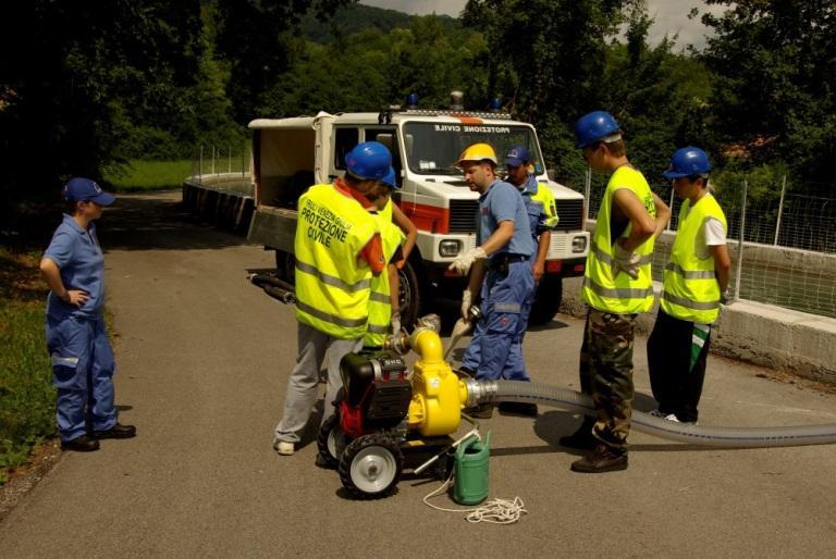
8 Volunteers FVG Civil Protection Volunteers in the Municipality Groups: 216 technical and logistical teams 119 fire-fighting teams 1 water rescue team More than volunteers Equipments More than 650 operative vehicles Civil Protection Associations: 80 associations More than volunteers


9 Seismic Risk Forest fire Risk Hydro Geological Risk: landslides floods debris-flow high-water, storm Natural Risks


10 31st October 2nd November 2010 Flood Basins of Livenza river Sacile - Pordenone 811 mm in 72 hours 150 mm in 6 hours Meduna River in Prata di Pordenone Confluence Meduna River Livenza River in Tremeacque Flooding in Pasiano di Pordenone Livenza River in Sacile
11 Main tools for risk management and realisation of prevention actions Regional Operative Room (SOR) in Palmanova Territory real-time control and monitoring systems Emergency planning Prevention, fast intervention and restoration works Civil protection personnel, volunteers and population training

12 Regional Operative Room in Palmanova (SOR) from 2017 Free phone number UE emergency number
 Seismic Monitoring")
13 Territory real-time control and monitoring systems The data from all of the Civil Protection Monitoring Networks are collected in the Operative Centre in Palmanova : Hydro-Meteo-Marine monitoring network Hydro Geological monitoring network Meteorological Radars for nowcasting Satellite observations (Meteosat MSG) Seismic Monitoring Network


14 Hydro Meteo Marine monitoring network Real time monitoring ground effects of meteorological events by automatic monitoring network managed by regional civil protection : 191 monitoring stations 111 hydrometers 112 rain gages 27 barometers 100 air thermometers 5 sea level sensors 18 snow level sensors 4 present weather sensors
15 Hydro Geological monitoring


16 Example of a real-time monitoring system (Passo Pramollo) Tiltmeters 4 parameters Surface cable extensometers Depth extensometers


17 Example of monitoring system (Passo Pramollo) Laserscan relief by helicopter Foot of the landslide Geology of the area Potential basin of water

 and")
18 Meteorological Radars for nowcasting Fossalon Radar Mount Zouf Plan Radar Meteorological radar data are used for civil protection purposes in order to detect and monitor critical events and, during the phase of meteorological nowcasting The meteorological radar of DPC installed on Mount Zouf Plan grants the maximum coverage of the mountain area of FVG and also of part of Carinzia region (Austria) and Slovenia
19 Emergency planning


20 Emergency plans web portal Regional Civil Protection structure COR Emergency Regional Centre coordination Civil protection municipality headquarters Regional Forest corp local headquarters Hospitals 20


21 Emergency plans web portal 3 levels Web access : Citizens Municipalities Prefectures and Region 3 levels of specific details for every function. Citizens have at disposal only information of their interest and auto-protection raccomandations.


22 Other data censed Emergency Areas Municipal emergency areas web management system Census Areas of the municipalities A Waiting Area B1 - Shelter Area - not covered B2 - Shelter Area - covered C Storage area for Rescuers D Area for landing helicopters PC - Municipal civil protection center RI - Checkpoint on the territory ES Strategic building ER Relevant building municipal emergency areas (2017) 22


23 App MoPiC FVG civil protection municipality emergency plans mobile application FREE download from Google play or AppStore

24 C.F.D. Friuli Venezia Giulia Decentralized Functional Centre Direttiva P.C.M. 27/02/2004 e s.m.i.

25 D.P.C.M. del 27th February 2004 Alert System Responsibles Council of Ministers Presidency - National Civil Protection Department Regional Governments Presidencies - Regional Subjects National Alert System managed through National Functional Centre Network of Functional Centers and Competence Centers Decentralised Functional Centers C.F.D.
26 Decentralised Functional Centres: Location and competence area ( jurisdiction) Structures which, based on the information networks and knowledge of critical issues in the area, should provide technical support to the decision of the Civil Protection 21 Decentralised Functional Centres 1 National Functional Centre Competence Centers
27 ARPA FVG OSMER REGIONAL CIVIL PROTECTION METEO Sector IDROGEO Sector Regional Operative Room CFD - Decentralised Functional Centre

28 Everyday Risks evaluation : meteorological hydrogeological hydraulic Issue METEO SECTOR BULLETINS (dispatch): Regional meteorological supervisory Bulletin IDROGEO SECTOR Regional hydrogeological and hydraulic risk Bulletin


29 IdroGeo Sector EVALUATION FORECASTING RAIN SOIL MOISTURE ACTIVE LANDSLIDE AND FLOOD HYDROMETRIC LEVEL SNOW MELTING THRESOLDS SYSTEM
30 Rainfall thresholds system For precipitation, according to a national study, the levels of the system of thresholds are based on the return time: Absence criticality No significant weather expected Ordinary criticality Return period rainfall forecast> 2 years Moderate criticality Return period rainfall forecast > 5 years Highly criticality Return period rainfall forecast > 10/20 years Punctual and areal rainfall thresholds for different areas of alert
 - 27 Nov 2002 Civil protection municipality")


31 Embankments surveillance phase Meduna river - Prata di Sopra (PN) - 27 Nov 2002 Civil protection municipality Groups are in charged of the surveillance of the embankments in order to permit a prompt hydraulic quick intervention in case of damages avoiding ruptures and flooding of inhabited areas Livenza river Loc. Traffe (PN) - 28 Nov 2002

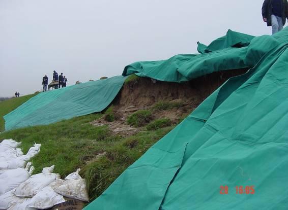


32 Embankment surveillance phase Infiltration Cracks


33 High-water service Coordination: Real-time GIS implementation Immediate perception and visualization of situation on field

34 The hydrological forecasting and management system of Friuli Venezia Giulia The Friuli Venezia Giulia Region has hydrological and hydraulic models for:: basin of rivers Cellina-Meduna basin of river Tagliamento basin of river Isonzo with GIS interface for environmental monitoring and high water real-time forecasting.
35 Prevention, quick intervention and restoration works


36 Flood 2002 Pordenone embankment s break Steel screen


37 Flood 2003 (Pietratagliata) River side defenses and new bridge Temporary rock cliff defense Bailey bridge


38 Young volunteers training Informations to citizens PREVENTION, through...


39 Meetings and exercises at school with civil protection personnel, volunteers and students

40 Friuli Venezia Giulia Civil Protection Web Portal


41 Social Network

42 Thank you for your attention
The Civil Protection System of the Autonomous Region of Friuli Venezia Giulia (Italy)
") The Civil Protection System of the Autonomous Region of Friuli Venezia Giulia (Italy) Geol. Raffaele Lotto La Plata, November 2017 Friuli Venezia Giulia Autonomous Region Austria Pordenone Udine Gorizia
The Civil Protection System of the Autonomous Region of Friuli Venezia Giulia (Italy) Geol. Raffaele Lotto La Plata, November 2017 Friuli Venezia Giulia Autonomous Region Austria Pordenone Udine Gorizia
THE ISONZO SOČA RIVER BASIN
 relator: PhD Geologist Alberto Cisotto e-mail: alberto.cisotto@adbve.it www.adbve.it THE ISONZO SOČA RIVER BASIN Eastern Alps District (NE Italy W Slovenia) Workshop on Transboundary Water Cooperation
12/07/2017. Flash Flood Warning Service, an advanced approach towards flood resilient cities Floodplain Management Association Conference, Newcastle
 12/07/2017 Worldwide problem: Flash Floods Flash Floods are a Global Problem Flash Flood Warning Service, an advanced approach towards flood resilient cities Floodplain Management Association Conference,
Mitigation planning in Epirus- The case of frost and snowfalls. Thematic seminar Epirus September 2011
 Mitigation planning in Epirus- The case of frost and snowfalls Thematic seminar Epirus September 2011 1 Structure of Mitigation Planning in Greece First Level: General Plan for Civil Protection Ksenokratis
United States Multi-Hazard Early Warning System
 United States Multi-Hazard Early Warning System Saving Lives Through Partnership Lynn Maximuk National Weather Service Director, Central Region Kansas City, Missouri America s s Weather Enterprise: Protecting
WHAT S CIVIL DEFENCE?
 WHAT S CIVIL DEFENCE? The Civil Protection Department was found in 1982 in order to prevent, forecast and supervise the natural disasters in agreement with regional and local governments. It also cooperates
Analysis of catastrophic floods affecting Croatia in May 2014 Meteorological and Hydrological Service Zagreb, Croatia
 Analysis of catastrophic floods affecting Croatia in May 2014 Meteorological and Hydrological Service Zagreb, Croatia http://meteo.hr Branka Ivančan-Picek e-mail: picek@cirus.dhz.hr Overview The most affected
MANAGEMENT OF THE NIEMEN RIVER BASIN WITH ACCOUNT OF ADAPTATION TO CLIMATE CHANGE. Hydro-meteorological Monitoring System
 MANAGEMENT OF THE NIEMEN RIVER BASIN WITH ACCOUNT OF ADAPTATION TO CLIMATE CHANGE Hydro-meteorological Monitoring System Draft Interim Report Milestone 1 Giovanni Crema 18 October 2012 Scope of work assessment
Emerging Needs, Challenges and Response Strategy
 Emerging Needs, Challenges and Response Strategy Development of Integrated Observing Systems in China JIAO Meiyan Deputy Administrator China Meteorological Administration September 2011 Geneva Outline
Thunderstorm Forecasting and Warnings in the US: Applications to the Veneto Region
 Thunderstorm Forecasting and Warnings in the US: Applications to the Veneto Region Bill Conway Vice President Weather Decision Technologies Norman, Oklahoma, USA Andrea Rossa ARPAV Lead Scientist Centre
ÖBB Natural Hazard Management
 ÖBB Natural Hazard Management Management of Weather Events in the Austrian Federal Railways MOWE-IT, Brussels 17 th of September 2013 DI Günther Kundela Integrated Track Management Integration Technic
Integrating Nowcastingwith crisis management and risk prevention in a transnational framework (INCA-CE)
") Integrating Nowcastingwith crisis management and risk prevention in a transnational framework (INCA-CE) Yong Wang ZAMG, Austria This project is implemented through the CENTRAL EUROPE Programme co-financed
Integrating Nowcastingwith crisis management and risk prevention in a transnational framework (INCA-CE) Yong Wang ZAMG, Austria This project is implemented through the CENTRAL EUROPE Programme co-financed
THE ISONZO SOČA. Workshop on Transboundary Water Cooperation in Central and Western Europe. Eastern Alps District.
 relator: PhD Geologist Alberto Cisotto e-mail: alberto.cisotto@adbve.it www.adbve.it THE ISONZO SOČA RIVER BASIN Eastern Alps District (NE Italy W Slovenia) Workshop on Transboundary Water Cooperation
Flash flood forecasting and warning infrastructures of National Meteorology and Hydrological Services of Cambodia
 Development and Implementation of the South East Asia Flash Flood Guidance System (SEAFFGS) Ha Noi, Viet Nam, 20-23 November 2017 Flash flood forecasting and warning infrastructures of National Meteorology
WMO/WWRP FDP: INCA CE
 WMO/WWRP FDP: INCA CE Yong Wang ZAMG, Austria This project is implemented through the CENTRAL EUROPE Programme co-financed by the ERDF INCA CE: implementation over Central Europe A Nowcasting Initiative
Europass Curriculum Vitae
 Europass Curriculum Vitae Personal information First name(s) / Surname(s) Francesco Silvestro Telephone(s) +39 019 861418 E-mail fdrancesco.silvestro@cimafoundation.org Nationality Italian Date of birth
INCA CE: Integrating Nowcasting with crisis management and risk prevention in a transnational framework
 INCA CE: Integrating Nowcasting with crisis management and risk prevention in a transnational framework Yong Wang ZAMG, Austria This project is implemented through the CENTRAL EUROPE Programme co-financed
DRR-related mandates and relevant activities and projects of RA III
 DRR-related mandates and relevant activities and projects of RA III 2015 Meeting of the Disaster Risk Reduction Focal Points of WMO Regional Associations, Technical Commissions and Programmes (DRR FP RA-TC-TP)
Instituto de Pesquisas Meteorológicas - IPMet Universidade Estadual Paulista - Unesp
 IPMET WEB GIS APPLICATION FOR SEVERE WEATHER ALERT AND DECISION SUPPORT Jaqueline Murakami Kokitsu Instituto de Pesquisas Meteorológicas - IPMet Universidade Estadual Paulista - Unesp IPMet/Unesp Meteorological
TOOLS FOR RISK MANAGEMENT Related to climate change
 TOOLS FOR RISK MANAGEMENT Related to climate change copyright CONTENT 1 CLIMATE CHANGE AND ENVIRONMENTAL STUDIES 2 METHODS AND TOOLS DEVELOPED BY EGIS For infrastructures For urban areas For crisis management
CLIMATE CHANGE ADAPTATION BY MEANS OF PUBLIC PRIVATE PARTNERSHIP TO ESTABLISH EARLY WARNING SYSTEM
 CLIMATE CHANGE ADAPTATION BY MEANS OF PUBLIC PRIVATE PARTNERSHIP TO ESTABLISH EARLY WARNING SYSTEM By: Dr Mamadou Lamine BAH, National Director Direction Nationale de la Meteorologie (DNM), Guinea President,
GIS in Weather and Society
 GIS in Weather and Society Olga Wilhelmi Institute for the Study of Society and Environment National Center for Atmospheric Research WAS*IS November 8, 2005 Boulder, Colorado Presentation Outline GIS basic
Measures Also Significant Factors of Flood Disaster Reduction
 Non-Structual Measures Also Significant Factors of Flood Disaster Reduction Babiaková Gabriela, Leškov ková Danica Slovak Hydrometeorological Institute, Bratislava Hydrological Forecasts and Warning Department
Programs of Regione Campania for reduction of seismic risk (and others)
") Programs of Regione Campania for reduction of seismic risk (and others) 2011-10151015 Prof ing Edoardo Cosenza Assessore (Regional Ministry) Public Works and Civil Protection Regione Campania Napoli, 1900.
Programs of Regione Campania for reduction of seismic risk (and others) 2011-10151015 Prof ing Edoardo Cosenza Assessore (Regional Ministry) Public Works and Civil Protection Regione Campania Napoli, 1900.
Regional Flash Flood Guidance and Early Warning System
 WMO Training for Trainers Workshop on Integrated approach to flash flood and flood risk management 24-28 October 2010 Kathmandu, Nepal Regional Flash Flood Guidance and Early Warning System Dr. W. E. Grabs
Flash Flood Guidance System On-going Enhancements
 Flash Flood Guidance System On-going Enhancements Hydrologic Research Center, USA Technical Developer SAOFFG Steering Committee Meeting 1 10-12 July 2017 Jakarta, INDONESIA Theresa M. Modrick Hansen, PhD
PRE MONSOON TROPICAL CYCLONE ALERT (LAILA)
") PRE MONSOON TROPICAL CYCLONE ALERT (LAILA) (Updated as on 19 th May, 2010, 10.00 AM) A pre-monsoon Tropical Cyclone alert has been issued for all the coastal districts of Orissa by the Special Relief Commissioner
PRE MONSOON TROPICAL CYCLONE ALERT (LAILA) (Updated as on 19 th May, 2010, 10.00 AM) A pre-monsoon Tropical Cyclone alert has been issued for all the coastal districts of Orissa by the Special Relief Commissioner
URBAS Prediction and management of flash floods in urban areas
 URBAS Prediction and management of flash floods in urban areas 1 Thomas Einfalt, Klaus Friedeheim, Andreas Wagner Project funded by the Federal Ministry of Education and Research BMBF (Germany) as a part
TABLE OF CONTENTS LIST OF TABLES. Page
 TABLE OF CONTENTS Page 11.0 EFFECTS OF THE ENVIRONMENT ON THE PROJECT... 11-1 11.1 Weather Conditions... 11-1 11.2 Flooding... 11-2 11.3 Forest Fires... 11-2 11.4 Permafrost and Subsidence Risk... 11-3
THE STUDY ON 4S TECHNOLOGY IN THE COMMAND OF EARTHQUAKE DISASTER EMERGENCY 1
 THE STUDY ON 4S TECHNOLOGY IN THE COMMAND OF EARTHQUAKE DISASTER EMERGENCY 1 Zhou Wensheng 1, Huang Jianxi 2, Li Qiang 3, Liu Ze 3 1 Associate Professor, School of Architecture, Tsinghua University, Beijing.
Flash Flood Guidance Gazette
 Volume 1, Issue 4 December 2012 Flash Flood Guidance Gazette Flash Flood Guidance (FFG) Gazette, a bi-annual newsletter bringing users of FFG products all the latest news operational information, technical
Sri Lanka Enhancing the Role of ICTs for Disaster Risk Management
 Workshop on ICT for Promoting Inclusive and Disaster Resilient Development Ulaanbaatar, Mongolia Sri Lanka Enhancing the Role of ICTs for Disaster Risk Management Kanchana Thudugala Programme Head, eservices
EARLY WARNING SYSTEM AND THE ROLE OF METEOROLOGICAL AND HYDROLOGICAL SERVICE CROATIA
 EARLY WARNING SYSTEM AND THE ROLE OF METEOROLOGICAL AND HYDROLOGICAL SERVICE CROATIA Meteorological and Hydrological Service National Protection and Rescue Directorate B. Ivančan an-picek V. Stajčić Establishment
The PREVIEW project: general objectives and an overview of the landslides platform
 The PREVIEW project: general objectives and an overview of the landslides platform Risk Mitigation for Earthquakes and Landslides Giacomo Falorni Earth Sciences Dept. University of Firenze 19-20 July 2007
Smart use of Geographic Information System (GIS) platform for delivering weather information and nowcasting services
 platform for delivering weather information and nowcasting services") Smart use of Geographic Information System (GIS) platform for delivering weather information and nowcasting services C. K. Pan Hong Kong Observatory Hong Kong, China It is a world of beauty Source: Image
Smart use of Geographic Information System (GIS) platform for delivering weather information and nowcasting services C. K. Pan Hong Kong Observatory Hong Kong, China It is a world of beauty Source: Image
INCA-CE achievements and status
 INCA-CE achievements and status Franziska Strauss Yong Wang Alexander Kann Benedikt Bica Ingo Meirold-Mautner INCA Central Europe Integrated nowcasting for the Central European area This project is implemented
Challenges in providing effective flood forecasts and warnings
 Challenges in providing effective flood forecasts and warnings National Centre for Flood Research Inaugural Symposium Justin Robinson Bureau of Meteorology October 2018 Zero Lives Lost A key responsibility
Early Warning System and Role of IMD. Manmohan Singh Meteorological Centre Shimla
 Early Warning System and Role of IMD Manmohan Singh Meteorological Centre Shimla India a land with a unique climatic regime Two monsoon seasons (southwest & northeast monsoons) Two cyclone seasons (pre
C o p e r n i c u s E m e r g e n c y M a n a g e m e n t S e r v i c e f o r e c a s t i n g f l o o d s
 C o p e r n i c u s E m e r g e n c y M a n a g e m e n t S e r v i c e f o r e c a s t i n g f l o o d s Copernicus & Copernicus Services Copernicus EU Copernicus EU Copernicus EU www.copernicus.eu W
Progress Report. Flood Hazard Mapping in Thailand
 Progress Report Flood Hazard Mapping in Thailand Prepared By: Mr. PAITOON NAKTAE Chief of Safety Standard sub-beuro Disaster Prevention beuro Department of Disaster Prevention and Mitigation THAILAND E-mail:
Improvement of Hazard Assessment and Management in the Philippines
 Improvement of Hazard Assessment and Management in the Philippines (2014 Summer Training Course for Slope Land Disaster Reduction) Ian Alejandrino (Philippines) Nguyen Manh Hieu (Vietnam) Presentation
Research Activities at CIMA Foundation and contributions to task teams activities
 4 HyMeX Workshop Bologna, 8-10 June 2010 Research Activities at CIMA Foundation and contributions to task teams activities G. Boni(1), F. Castelli(2,1), L. Ferraris(1), S. Gabellani(1), A. Parodi(1), N.
Two case history of EMS data application: earthquake in central italy and flooding in Piedmont region
 Two case history of EMS data application: earthquake in central italy and flooding in Piedmont region Luca Lanteri*, Rocco Pispico*, R. Cremonini** *Arpa Piemonte, Geological and Natural Risk Dipartiment
Michel Jean et al., Meteorological Service of Canada Région du Québec Mai, 2009
 Vigilance Map: Risk Communication Tool - From Regional Pilot Project to National Project Presented at Second Experts Symposium on Multi-Hazard Early Warning Systems (MHEWS-II) Michel Jean et al., Meteorological
Rebuilding Flood-Conscious Society
 A zone where strong flood flow or river bank erosion by levee breach are anticipated, which likely to occur collapsing/washing away of house. Set up the joint councils by relative stakeholders(river managers,
Spatial Optimization of CoCoRAHS Network in Tennessee. Joanne Logan Department of Biosystems Engineering and Soil Science University of Tennessee
 Spatial Optimization of CoCoRAHS Network in Tennessee Joanne Logan Department of Biosystems Engineering and Soil Science University of Tennessee Abstract CoCoRaHS (Community Collaborative Rain, Hail and
Local government of El Prat de Llobregat is working with the Metropolitan Area of Barcelona teamwork on resilience to climate change
 Local government of El Prat de Llobregat is working with the Metropolitan Area of Barcelona teamwork on resilience to climate change Adaptation plan to climate change at AMB Barcelona, resilient city on
SEISMIC RISK ASSESSMENT IN ARMENIA
 SEISMIC RISK ASSESSMENT IN ARMENIA Hovhannes Khangeldyan Head of National Crisis Management Center Rescue Service Ministry of Emergency Situations of the Republic of Armenia Tokyo, 2016 ARMENIA: GEOGRAPHICAL
HISTORY OF HEAVY RAINFALL DISASTER INFORMATION IN JAPAN
 transmission, for a state-of-the-art review. In addition, issues expected to arise in the future are discussed. HISTORY OF HEAVY RAINFALL DISASTER INFORMATION IN JAPAN Progress of Rainfall Observation
Role of Hydro-Met Services in Disaster Risk Management
 Role of Hydro-Met Services in Disaster Risk Management Tshewang Rigzin (Mr) National Centre for Hydrology and Meteorology, Bhutan 30 th November 2017 Outline Vision and Mission Functions related to Disaster
Overview of Early Warning Systems and the role of National Meteorological and Hydrological Services
 Overview of Early Warning Systems and the role of National Meteorological and Hydrological Services South Africa Second Experts Symposium on Multi-Hazard Early Warning Systems With focus on the Role of
APPROACH TO THE SPANISH WATER ORGANISATION IMPROVING FLOOD HAZARD MAPPING, LAWS AND AUTHORITIES COORDINATION
 "Workshop On Land Use Planning And Water Management, With Focus On Flood Risk Management Oslo, Norway. Wednesday 31 January and Thursday 1 February 2007 APPROACH TO THE SPANISH WATER ORGANISATION IMPROVING
THE ADRIARadNet PROJECT
 THE ADRIARadNet PROJECT Activity carried out by Abruzzo Region: Results, problems, aims A. Santacasa, G. Ragni, L. Tontodimamma, F. Rossi, A. Cimoroni, B. Di Giacomantonio, A. Iovino The main project activities
I&CLC2000 in support to new policy initiatives (INSPIRE, GMES,..)
") I&CLC2000 in support to new policy initiatives (INSPIRE, GMES,..) Manfred Grasserbauer, Director Joint Research Centre Institute for Environment and Sustainability 1 IMAGE 2000 European mosaic of satellite
I&CLC2000 in support to new policy initiatives (INSPIRE, GMES,..) Manfred Grasserbauer, Director Joint Research Centre Institute for Environment and Sustainability 1 IMAGE 2000 European mosaic of satellite
Flood Forecasting Methodology in Alberta
 Flood Forecasting Methodology in Alberta Evan Friesenhan, M.Eng., P.Eng Alberta Environment and Sustainable Resource Development February 18, 2014 River Forecast Team Mandate To provide Albertans with
FLORA: FLood estimation and forecast in complex Orographic areas for Risk mitigation in the Alpine space
 Natural Risk Management in a changing climate: Experiences in Adaptation Strategies from some European Projekts Milano - December 14 th, 2011 FLORA: FLood estimation and forecast in complex Orographic
Flood Management in Japan
 Flood Management in Japan 1. Comprehensive Flood Control Measures 2. Provision of River information 3. Responses to the Niigata Torrential Rain Disaster 4. About ICHARM 5. Responses to 2011 Thailand Floods
Climate change and natural disasters, Athens, Greece October 31, 2018
 Flood early warning systems: operational approaches and challenges Climate change and natural disasters, Athens, Greece October 31, 2018 Athens, October 31, 2018 Marco Borga University of Padova, Italy
GIS Geographical Information Systems. GIS Management
 GIS Geographical Information Systems GIS Management Difficulties on establishing a GIS Funding GIS Determining Project Standards Data Gathering Map Development Recruiting GIS Professionals Educating Staff
Use of Climate information in Disaster Risk Management in Zimbabwe
 Use of Climate information in Disaster Risk Management in Zimbabwe WMO Regional Technical Meeting & User/CONOPS Workshop, 28 th October 2015 Lameck Betera Department of Civil Protection Institutional Arrangements
13.2 USING VIRTUAL GLOBES TO IMPROVE SITUATIONAL AWARENESS IN THE NATIONAL WEATHER SERVICE
 13.2 USING VIRTUAL GLOBES TO IMPROVE SITUATIONAL AWARENESS IN THE NATIONAL WEATHER SERVICE Andy Foster* National Weather Service Springfield, Missouri* Keith Stellman National Weather Service Shreveport,
Landslide Hazards: A Stealth Threat to the Nation
 Landslide Hazards: A Stealth Threat to the Nation Sponsored by the Geological Society of America Association of Environmental & Engineering Geologists American Society of Civil Engineers In Cooperation
GEOMATICS. Shaping our world. A company of
 GEOMATICS Shaping our world A company of OUR EXPERTISE Geomatics Geomatics plays a mayor role in hydropower, land and water resources, urban development, transport & mobility, renewable energy, and infrastructure
MODERN TECHNOLOGIES IN HYDRO-METEOROLOGICAL INFORMATION SYSTEMS
 MODERN TECHNOLOGIES IN HYDRO-METEOROLOGICAL INFORMATION SYSTEMS MARK HEGGLI, INNOVATIVE HYDROLOGY CONSULTING METEOROLOGIST/HYDROLOGIST TO THE WORLD BANK AREAS OF TECHNOLOGY ADVANCEMENT RECENT TECHNOLOGY
Flood Forecasting Methodology in Alberta
 Flood Forecasting Methodology in Alberta Colleen Walford, P.Eng Alberta Environment and Sustainable Resource Development March 24, 2014 River Forecast Team Mandate To provide Albertans with information
BARON END-TO-END HYDROLOGICAL MODELING SOLUTION NOW AVAILABLE IN NEW BARON LYNX DISPLAY
 4930 Research Drive Huntsville, AL 35805 (256)-881-8811 www.baronweather.com FOR IMMEDIATE RELEASE BARON END-TO-END HYDROLOGICAL MODELING SOLUTION NOW AVAILABLE IN NEW BARON LYNX DISPLAY Powerful scientific
Copernicus Overview. Major Emergency Management Conference Athlone 2017
 Copernicus Overview Major Emergency Management Conference Athlone 2017 Copernicus is a European programme implemented by the European Commission. The services address six thematic areas: land, marine,
LANDSLIDE MONITORING AND EARLY WARNING SYSTEMS IN AUSTRIA
 LANDSLIDE MONITORING AND EARLY WARNING SYSTEMS IN AUSTRIA --- 1 --- ALPINE HAZARDS IN AUSTRIA Austria is exposed to heavy precipitation, hails, thunderstorms and avalnches in winter 100.000 km rivers and
IRDAT Fvg, evolving a regional Spatial Data Infrastructure according to INSPIRE
 IRDAT Fvg, evolving a regional Spatial Data Infrastructure according to INSPIRE Tutti i diritti riservati. Proprietà INSIEL SpA. A. Benvenuti, A. Chiarandini Insiel (Italy) M. Lunardis - Friuli Venezia
USING 3D GIS TO ASSESS ENVIRONMENTAL FLOOD HAZARDS IN MINA
 King Fahd University of Petroleum & Minerals College of Environmental Design Geographical Information system USING 3D GIS TO ASSESS ENVIRONMENTAL FLOOD HAZARDS IN MINA Prepared by : Ali AL-Zahrani OUTLINE
National Public Weather and Warning Services in the Swaziland Meteorological Service Dennis S.Mkhonta /
 National Public Weather and Warning Services in the Swaziland Meteorological Service Dennis S.Mkhonta dennis.mkhonta@gmail.com / dennis@swazimet.gov.sz Introduction Swaziland s geographical position exposes
COMMUNITY EMERGENCY RESPONSE TEAM FLOODS INTRODUCTION
 INTRODUCTION Floods are one of the most common hazards in the United States. A flood occurs any time a body of water rises to cover what is usually dry land. Flood effects can be local, impacting a neighborhood
2017 Fall Conditions Report
 2017 Fall Conditions Report Prepared by: Hydrologic Forecast Centre Date: November 15, 2017 Table of Contents TABLE OF FIGURES... ii EXECUTIVE SUMMARY... 1 BACKGROUND... 4 SUMMER AND FALL PRECIPITATION...
DISASTER MANAGEMENT AND PREPAREDNESS PLAN
 DISASTER MANAGEMENT AND PREPAREDNESS PLAN Publisher : M.Thennarasan IAS Municipal ommissioner oncept by : Implimantation : B. I. Desai Deputy ommissioner D. M. Jariwala Addi.ity Eng. (ivil) ompilation
Meteorological vigilance An operational tool for early warning
 Meteorological vigilance An operational tool for early warning Jean-Marie Carrière Deputy-director of Forecasting http://www.meteo.fr The French meteorological vigilance procedure Context Routine working
Applying Hazard Maps to Urban Planning
 Applying Hazard Maps to Urban Planning September 10th, 2014 SAKAI Yuko Disaster Management Expert JICA Study Team for the Metro Cebu Roadmap Study on the Sustainable Urban Development 1 Contents 1. Outline
FFGS Advances. Initial planning meeting, Nay Pyi Taw, Myanmar February, Eylon Shamir, Ph.D,
 FFGS Advances Initial planning meeting, Nay Pyi Taw, Myanmar 26-28 February, 2018 Eylon Shamir, Ph.D, EShamir@hrcwater.org Hydrologic Research Center San Diego, California FFG System Enhancements The following
THE WEATHER CASE STUDIES
 THE WEATHER CASE STUDIES Hedi Maurer, NEA (Panteia) Athens, 23.04.2012 Case studies, regions and modes 1. Flood of 2002 in Eastern Germany 2. Summer heat 2007 in Southern Europe 3. Flooding of the rail
EUMETSAT. A global operational satellite agency at the heart of Europe. Presentation for the Spanish Industry Day Madrid, 15 March 2012
 EUMETSAT A global operational satellite agency at the heart of Europe Presentation for the Spanish Industry Day Madrid, Angiolo Rolli EUMETSAT Director of Administration EUMETSAT objectives The primary
May 31, Flood Response Overview
 May 31, 2013 Flood Response Overview Suppression 867 Personnel on three (3) shifts 289 Red Shift (A) 289 Blue Shift (B) 289 Green Shift (C) Department Overview Department Overview EMS: 40,934 False Alarm:
Strategic Framework on Geospatial Information and Services for Disasters Relevance for the Americas Region
 Strategic Framework on Geospatial Information and Services for Disasters Relevance for the Americas Region Seventh Session of the Committee of Experts on UN-GGIM Side Event --- UN Headquarters, New York
Innovative Ways to Monitor Land Displacement
 ARTICLE Innovative Ways to Monitor Land Displacement When people think about landslides, they usually imagine large mud streams which cause considerable loss of life. Whereas such large-scale disasters
California OES Weather Threat Briefing
 California OES Weather Threat Briefing Wednesday, January 16, 2019 9:00 AM PST Day 1: Strong winds, heavy mountain snow and heavy rain with isolated thunderstorms across much of the state through Thursday
H SAF SATELLITE APPLICATION FACILITY ON SUPPORT TO OPERATIONAL HYDROLOGY AND WATER MANAGEMENT EUMETSAT NETWORK OF SATELLITE APPLICATION FACILITIES
 H SAF SATELLITE APPLICATION FACILITY ON SUPPORT TO OPERATIONAL HYDROLOGY AND WATER MANAGEMENT EUMETSAT NETWORK OF SATELLITE APPLICATION FACILITIES H-SAF: SATELLITE PRODUCTS FOR OPERATIONAL HYDROLOGY H-SAF
Flood Forecasting Methodology in Alberta
 Flood Forecasting Methodology in Alberta Evan Friesenhan, M.Eng., P.Eng Alberta Environment and Sustainable Resource Development March 17, 2014 River Forecast Team Mandate To provide Albertans with information
An Overview of Operations at the West Gulf River Forecast Center Gregory Waller Service Coordination Hydrologist NWS - West Gulf River Forecast Center
 National Weather Service West Gulf River Forecast Center An Overview of Operations at the West Gulf River Forecast Center Gregory Waller Service Coordination Hydrologist NWS - West Gulf River Forecast
APPLICATIONS OF EARTHQUAKE HAZARD MAPS TO LAND-USE AND EMERGENCY PLANNING EXAMPLES FROM THE PORTLAND AREA
 APPLICATIONS OF EARTHQUAKE HAZARD MAPS TO LAND-USE AND EMERGENCY PLANNING EXAMPLES FROM THE PORTLAND AREA O. Gerald Uba Metro, Portland, Oregon OVERVIEW The extent to which we understand "below ground"
Linked Open Data usage in geohazard system supporting crisis management
 Linked Open Data usage in geohazard system supporting crisis management INSPIRE Aalborg, 16 20 June 2014 Tomasz Nałęcz Grzegorz Ryżyński Adam Iwaniak the Earth under our feet Critical mineral resources
Developing Products with Partners
 Developing Products with Partners Hydro-Climatology Products Integrated Water Resources Science & Service Community Hydrologic Prediction System Water Resources Outlook Precipitation Frequency Estimates
Trainee Manual C02 CITY OF SASKATOON. Water and Sewer Section. Severe Storm Response Trainee Manual. Version # 1-0-3
 Trainee Manual C02 CITY OF SASKATOON Water and Sewer Section Severe Storm Response Trainee Manual CITY OF SASKATOON Severe Storm Response Trainee Manual City of Saskatoon Severe Storm Response Trainees
Use of Geospatial data for disaster managements
 Use of Geospatial data for disaster managements Source: http://alertsystemsgroup.com Instructor : Professor Dr. Yuji Murayama Teaching Assistant : Manjula Ranagalage What is GIS? A powerful set of tools
Flood Forecasting. Fredrik Wetterhall European Centre for Medium-Range Weather Forecasts
 Flood Forecasting Fredrik Wetterhall (fredrik.wetterhall@ecmwf.int) European Centre for Medium-Range Weather Forecasts Slide 1 Flooding a global challenge Number of floods Slide 2 Flooding a global challenge
3/3/2013. The hydro cycle water returns from the sea. All "toilet to tap." Introduction to Environmental Geology, 5e
 Introduction to Environmental Geology, 5e Running Water: summary in haiku form Edward A. Keller Chapter 9 Rivers and Flooding Lecture Presentation prepared by X. Mara Chen, Salisbury University The hydro
Use of satellite information in research and operational activities at NIMH of Bulgaria
 Use of satellite information in research and operational activities at NIMH of Bulgaria Rilka Valcheva NIMH, Bulgaria WMO/EUMETSAT Satellite Products Training Course 24-28 April 2017, Budapest, Hungary
New Concept of Regional Cooperation in Asia for Water Disaster Management Applying Satellite Precipitation Measurement
 New Concept of Regional Cooperation in Asia for Water Disaster Management Applying Satellite Precipitation Measurement Yusuke Muraki Japan Aerospace Exploration Agency (JAXA) Mission Planning Department
WHAT HAPPENS WHEN A TORNADO STRIKES THE COMMUNITY? Carroll County Sheriff s Office Emergency Management
 WHAT HAPPENS WHEN A TORNADO STRIKES THE COMMUNITY? Carroll County Sheriff s Office Emergency Management WHAT IS EMERGENCY MANAGEMENT? Carroll County Sheriff s Office Emergency Management Agency is responsible
National Report on Weather Forecasting Service
 MINISTRY OF WATER RESOURCES AND METEOROLOGY DEPARTMENT OF METEOROLOGY, CAMBODIA National Report on Weather Forecasting Service Tokyo, 11-15 March 2014 Department of Meteorology, Cambodia Presentation Outline
Need of Proper Development in Hilly Urban Areas to Avoid
 Need of Proper Development in Hilly Urban Areas to Avoid Landslide Hazard Dr. Arvind Phukan, P.E. Cosultant/Former Professor of Civil Engineering University of Alaska, Anchorage, USA RI District Governor
SNOW LEVEL FORECASTING METHODS AND PARAMETERS; TWO PRACTICAL EXAMPLES ON EASTERN ITALIAN ALPS
 P 1.12 SNOW LEVEL FORECASTING METHODS AND PARAMETERS; TWO PRACTICAL EXAMPLES ON EASTERN ITALIAN ALPS 1. Gianni Marigo*; 2. Thierry Robert-Luciani; 3. Andrea Crepaz Environmental Agency of the Veneto Region
Table-Top Exercise for Emergency Preparedness Evaluation: Little Anse, Isle Madame
 Table-Top Exercise for Emergency Preparedness Evaluation: Little Anse, Isle Madame Alexander Chung, M.Sc. Candidate C-Change Student Research Associate May 2013 The Community of Little Anse Coastal community