TOOLS FOR RISK MANAGEMENT Related to climate change
|
|
|
- Annabel Jefferson
- 5 years ago
- Views:
Transcription


1 TOOLS FOR RISK MANAGEMENT Related to climate change copyright
2 CONTENT 1 CLIMATE CHANGE AND ENVIRONMENTAL STUDIES 2 METHODS AND TOOLS DEVELOPED BY EGIS For infrastructures For urban areas For crisis management

3 CLIMATE CHANGE AND ENVIRONMENTAL STUDIES
,")

4 R&D PROGRAM BY EGIS helping decision makers and managers of industrial plants and infrastructures etc., Objectives of the tools and methods developed Being applied at different scales: local (project-based), road and rail infrastructures, or at national scale. They are intended to enrich the existing environmental assessment of programs, plans and projects. They bring elements to anticipate the management of extreme climate events.
5 LINK BETWEEN CLIMATE CHANGE AND EIA Development of tools to guide and support stakeholders : To avoid or reduce risk where possible To transfer risk where feasible To manage residual risk

6 METHODS AND TOOLS copyright
7 CLIMATE CHANGE AND INFRASTRUCTURE Two points : 1. Existing infrastructure is not generally sized to respond to extreme weather events Structural design knowledge from the past while changes in the climate system could induce extreme events exacerbated - increased intensities but also sustained over a longer period - 2. The social acceptability towards risk decreases Inclusion of critical weather events in the design, operation and maintenance of infrastructure as well as in land management A NECESSITY
8 CRITICAL PHENOMENA AND CONSEQUENCES Extreme rainfall floods, traffic stop, erosion, landslides... Seasonal annual rainfall landslide, cracking the pavement Rising sea level cutting and coastal erosion Maximum temperatures risk of rutting some asphalt, bridge expansion / concrete / rails, fire Winds panels falls, trees, power outages But critical event often combine several risk factors (eg. rain + winds, drought + heat wave... )


9 METHODS Communication 1. Context analysis 2. Risk identification 3. Risk analysis 4. Risk evaluation 5. Risk mitigation 6. Implementation of action plans 7. Monitoring, review, capitalization Feed back loop
10 GERICI - RESILIENCE GERICI (gestion des risques liés au changement climatique pour les infrastructures routières) was developed in 2007 to assess risks caused by climate change to road infrastructures and then adapting infrastructure management to it. In the same way, RESILIENCE was developed to assess risks caused by climate change to rail infrastructure. They are both suitable at the infrastructure scale only.
 Capitalization of events GIS Interpretation")


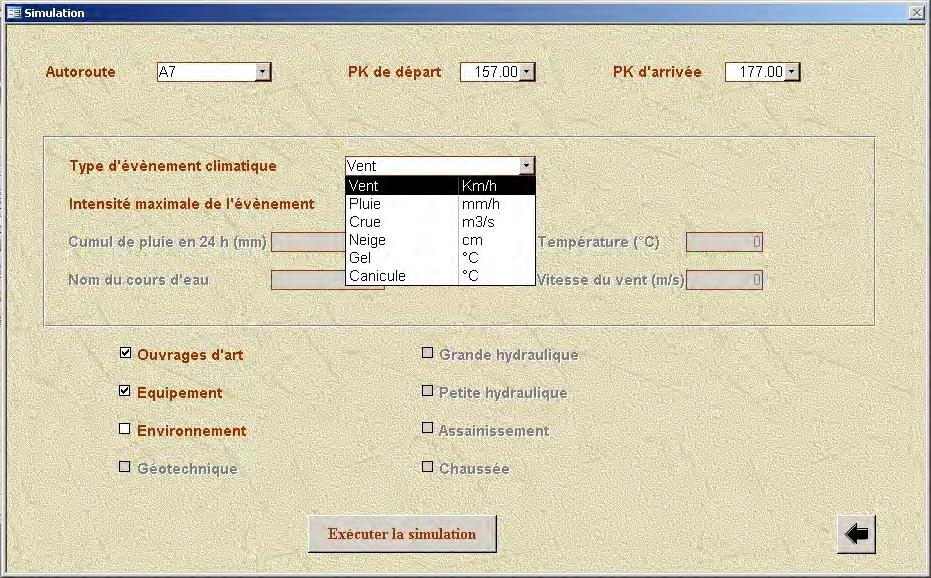
11 GERICI - RESILIENCE Infrastructure database Meteorological data (real or simulated extreme event) Capitalization of events GIS Interpretation system of infrastructure vulnerability to extreme weather event Location-based visualization of the consequences of extreme weather events on infrastructure components Hydraulic Structures Pavement Objects: Equipment and operating facilities Environment (isolated trees... ) Geotechnical
12 GERICI - RESILIENCE


13 GERICI - RESILIENCE Simulations at a section or a network Risk map

 but not its limit break 2 groves of large trees around kilometer point 161 (in red) are likely strong")
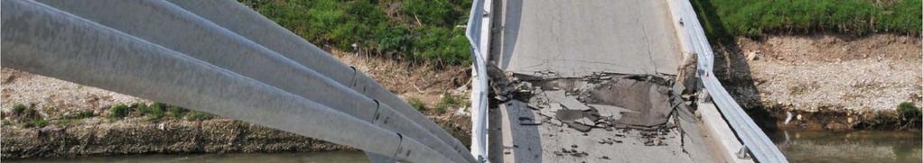
14 GERICI Meteo-France has launched an alert 'storm' forecast at 24 hours with winds around 160 km/h. The simulation by GERICI Section warns that: The Panel variable message at kilometer point is OK (in green) The noise barrier at kilometer point 162 exceeds its limited calculation to the wind (in orange) but not its limit break 2 groves of large trees around kilometer point 161 (in red) are likely strong fall and cut traffic on the motorway

 in North Africa.")
15 CLIMATE CHANGE AND URBAN AREAS A specific method for vulnerable urban areas : Developed and implemented between 2009 and 2011 for three coastal towns (Alexandria / Egypt, Tunis / Tunisia and Casablanca / Morocco) in North Africa. Funded largely by the World Bank


16 SPECIFIC METHOD FOR VULNERABLE URBAN AREAS Methods Vulnerable to extreme weather events exacerbated by climate changes to come Location of these 3 cities Densely populated areas Growing urbanization Understand the risks Identify and locate vulnerabilities Measure the degree of risk exposure : Flooding and storm surges Earthquakes and tsunamis Other extreme weather events Evaluate the costs of potential losses 1. Simulations at a district level 2. Risk map
17 ESPADA : FOR CRISIS MANAGEMENT Tool for the prediction and management of actual floods in urban areas : To avoid human disasters when floods appear. Developed by Egis after large-scale flooding in the south of France in 2002 and 2003 which caused the death of 22 people. ESPADA means Evaluation and monitoring of rain in urban areas for anticipating the alert (Évaluation et Suivi des Pluies en Agglomération pour Anticiper l Alarme)


 developed by")
18 ESPADA : FOR CRISIS MANAGEMENT Monitoring and hydro meteorological forecasting for the anticipation of stormy events Management of alarms and flood alerts Management of alternative plans Turnkey system (PC crisis, hardware computer furniture and communication, software, video surveillance cameras, warranty and maintenance) developed by BCEOM, CS - SI, Meteo-France


19 Acquisition of Data weather Rain forecast Decision Emergency plan : actions Prediction of the risk scenario Decision support Acquisition of data from measurements of the heights of water station Flood prediction Crisis communication
20 Thank you for your attention. CONTACT Virginie DEFROMONT Operational Performance Manager


21 EGIS GROUP 21
Use of Geospatial data for disaster managements
 Use of Geospatial data for disaster managements Source: http://alertsystemsgroup.com Instructor : Professor Dr. Yuji Murayama Teaching Assistant : Manjula Ranagalage What is GIS? A powerful set of tools
Disaster Risk Reduction and
 6 th ICRM Symposium 2015 Disaster Risk Reduction and 2015/04/23 Resilience in Taipei Outline Natural Disaster and Loss in Taiwan Climate Change and Geohazard Hazard Alert & App Monitoring & Modeling Land
CLIMATE CHANGE ADAPTATION BY MEANS OF PUBLIC PRIVATE PARTNERSHIP TO ESTABLISH EARLY WARNING SYSTEM
 CLIMATE CHANGE ADAPTATION BY MEANS OF PUBLIC PRIVATE PARTNERSHIP TO ESTABLISH EARLY WARNING SYSTEM By: Dr Mamadou Lamine BAH, National Director Direction Nationale de la Meteorologie (DNM), Guinea President,
Use of Climate information in Disaster Risk Management in Zimbabwe
 Use of Climate information in Disaster Risk Management in Zimbabwe WMO Regional Technical Meeting & User/CONOPS Workshop, 28 th October 2015 Lameck Betera Department of Civil Protection Institutional Arrangements
Paul Bridge Meteorologist Vaisala/UKMO Work Groups/Committees: WMO/TRB/AMS
 Paul Bridge Meteorologist Vaisala/UKMO Work Groups/Committees: WMO/TRB/AMS Introduction (a) Identify and establish, if possible, inventories of transport networks in the ECE region which are vulnerable
By Lillian Ntshwarisang Department of Meteorological Services Phone:
 By Lillian Ntshwarisang Department of Meteorological Services Phone: +267 3612200 Email: lntshwarisang@gov.bw/ lntshwarisang@gmail.com Introduction Mandate of DMS Function of the Department Services to
Smart use of Geographic Information System (GIS) platform for delivering weather information and nowcasting services
 platform for delivering weather information and nowcasting services") Smart use of Geographic Information System (GIS) platform for delivering weather information and nowcasting services C. K. Pan Hong Kong Observatory Hong Kong, China It is a world of beauty Source: Image
Smart use of Geographic Information System (GIS) platform for delivering weather information and nowcasting services C. K. Pan Hong Kong Observatory Hong Kong, China It is a world of beauty Source: Image
The UN-GGIM: Europe core data initiative to encourage Geographic information supporting Sustainable Development Goals Dominique Laurent, France
 INSPIRE conference Strasbourg 6 September 2017 The UN-GGIM: Europe core data initiative to encourage Geographic information supporting Sustainable Development Goals Dominique Laurent, France Introduction
DEVELOPMENT OF A FORECAST EARLY WARNING SYSTEM ethekwini Municipality, Durban, RSA. Clint Chrystal, Natasha Ramdass, Mlondi Hlongwae
 DEVELOPMENT OF A FORECAST EARLY WARNING SYSTEM ethekwini Municipality, Durban, RSA Clint Chrystal, Natasha Ramdass, Mlondi Hlongwae LOCATION DETAILS AND BOUNDARIES ethekwini Municipal Area = 2297 km 2
Understanding Weather and Climate Risk. Matthew Perry Sharing an Uncertain World Conference The Geological Society, 13 July 2017
 Understanding Weather and Climate Risk Matthew Perry Sharing an Uncertain World Conference The Geological Society, 13 July 2017 What is risk in a weather and climate context? Hazard: something with the
PUBLIC SAFETY POWER SHUTOFF POLICIES AND PROCEDURES
 PACIFIC GAS AND ELECTRIC COMPANY PUBLIC SAFETY POWER SHUTOFF POLICIES AND PROCEDURES SEPTEMBER 2018 1 PACIFIC GAS AND ELECTRIC COMPANY PUBLIC SAFETY POWER SHUTOFF POLICIES AND PROCEDURES SEPTEMBER 2018
12/05/2016. The First step in Adaptation to future climate change Reduce Vulnerability and Exposure to present Climate Variability (IPCC 2014)
") Integrating CCA, DRR and L+D to Address Emerging Challenges due to Slow Onset Processes Joy Jacqueline Pereira (Project Leader), SEADPRI-Universiti Kebangsaan Malaysia, Nguyen Van Thang (Collaborator),
Integrating CCA, DRR and L+D to Address Emerging Challenges due to Slow Onset Processes Joy Jacqueline Pereira (Project Leader), SEADPRI-Universiti Kebangsaan Malaysia, Nguyen Van Thang (Collaborator),
Weather forecasts and warnings: Support for Impact based decision making
 Weather forecasts and warnings: Support for Impact based decision making Gerry Murphy, Met Éireann www.met.ie An Era of Change Climate and weather is changing Societal vulnerability is increasing The nature
Global Challenges - Partnering with Service Providers. World Meteorological Organization. J. Lengoasa WMO Deputy Secretary-General
 WMO World Meteorological Organization Working together in weather, climate and water Global Challenges - Partnering with Service Providers J. Lengoasa WMO Deputy Secretary-General jlengoasa@wmo.int http://www.wmo.int/pages/gfcs/gfcs_en.html
Like other coastal cities, Honolulu s
 Worst-Case Scenarios: Flooding and Evacuation Plans in Honolulu Karl Kim, Pradip Pant, Eric Yamashita Like other coastal cities, Honolulu s long-term viability depends on how well it can adapt to climate
Recent development of the National Hydro-Meteorological Service (NHMS) of Viet Nam for disaster risk reduction
 of Viet Nam for disaster risk reduction") Ministry of Natural Resources and Environment National Hydro-Meteorological Service Recent development of the National Hydro-Meteorological Service (NHMS) of Viet Nam for disaster risk reduction Tran Van
Ministry of Natural Resources and Environment National Hydro-Meteorological Service Recent development of the National Hydro-Meteorological Service (NHMS) of Viet Nam for disaster risk reduction Tran Van
BLUEFIELDS EMERGENCY PLATFORM:
 BLUEFIELDS EMERGENCY PLATFORM: Community Early Warning Systems for Mitigating Hydro-Meteorological Impacts in Bluefields, Jamaica T. Hyman, J. Horney, B. Carby, K. Miller, M. Taylor OUTLINE Background
Workshop on Drought and Extreme Temperatures: Preparedness and Management for Sustainable Agriculture, Forestry and Fishery
 Workshop on Drought and Extreme Temperatures: Preparedness and Management for Sustainable Agriculture, Forestry and Fishery 16-17 Feb.2009, Beijing, China Modeling Apple Tree Bud burst time and frost risk
SECTION II Hydrological risk
 Chapter 3 Understanding disaster risk: hazard related risk issues SECTION II Hydrological risk Peter Salamon Coordinating lead author Hannah Cloke Lead author 3.4 Giuliano di Baldassarre Owen Landeg Florian
Caribbean Early Warning System Workshop
 Caribbean Early Warning System Workshop Hamonization in Existing EWS April 14-16, 2016 Presenter: Shawn Boyce Caribbean Institute for Meteorology and Hydrology Husbands, St. James Barbados Background Between
How Can DOT Operations and Maintenance Prepare for Extreme Weather Events?
 How Can DOT Operations and Maintenance Prepare for Extreme Weather Events? Gregory C. Johnson, P.E. Chief Operations Officer Michigan Department of Transportation November 17, 2012 Michigan s Climate Four
URBAS Prediction and management of flash floods in urban areas
 URBAS Prediction and management of flash floods in urban areas 1 Thomas Einfalt, Klaus Friedeheim, Andreas Wagner Project funded by the Federal Ministry of Education and Research BMBF (Germany) as a part
Monitoring and Warning Systems for Natural Phenomena The Mexican Experience
 Sistema Nacional de Protección Civil Monitoring and Warning Systems for Natural Phenomena The Mexican Experience Roberto Quaas W, Enrique Guevara O. O Mexican National Center for Disaster Prevention CENAPRED
Storm Surge/Coastal Inundation State of the Union. Jamie Rhome Storm Surge Team Lead NOAA/National Hurricane Center
 Storm Surge/Coastal Inundation State of the Union Jamie Rhome Storm Surge Team Lead NOAA/National Hurricane Center 2 Tampa: Cat 5 Scenario 3 4 The Stakes are High Combination of SLR and increasing coastal
ÖBB Natural Hazard Management
 ÖBB Natural Hazard Management Management of Weather Events in the Austrian Federal Railways MOWE-IT, Brussels 17 th of September 2013 DI Günther Kundela Integrated Track Management Integration Technic
Use of big data, crowdsourcing and GIS in assessment of weather-related impact
 Use of big data, crowdsourcing and GIS in assessment of weather-related impact HK (Photo courtesy : GFS) PAN Chi-kin, Hong Kong Observatory (Photo courtesy : Roy Liu/China Daily) November 2017, KMA/WMO
WINTER MAINTENANCE DECISIONS SUPPORT SYSTEMS IN POLAND Paweł Sobiesiak
 WINTER MAINTENANCE DECISIONS SUPPORT SYSTEMS IN POLAND Paweł Sobiesiak POLAND Area of Poland - 312 679 km² 69th largest country in the world 9th largest in Europe Population of over 38.5 million people
Global Atmospheric Circulation. Past climate change and natural causes. Global climate change and human activity
 GCSE Geography Edexcel B Revision Checklist Paper 1. Global Geographical Issues Topic 1. Hazardous Earth Key Idea I know/ understand The world s climate system Global Atmospheric Circulation Past climate
Miami-Dade County Overview
 Miami-Dade County Overview 2,000 square miles World s busiest cruise port 2.6 million residents Second busiest US airport for international travelers Gateway to the Caribbean and Latin America Natural
Assessing Hazards and Risk
 Page 1 of 6 EENS 204 Tulane University Natural Disasters Prof. Stephen A. Nelson Assessing Hazards and Risk This page last updated on 07-Jan-2004 As discussed before, natural disasters are produced by
Bistandsprosjekter i Sørøst-Asia
 Bistandsprosjekter i Sørøst-Asia -Sikre liv og verdier Lars R. Hole, Hanneke Luijting, Tor Ivar Mathisen og Kristine Gjesdal September 2017 Norwegian Meteorological Institute Background Ministry of Foreign
Emerging Needs, Challenges and Response Strategy
 Emerging Needs, Challenges and Response Strategy Development of Integrated Observing Systems in China JIAO Meiyan Deputy Administrator China Meteorological Administration September 2011 Geneva Outline
Sea-Level Rise Impacts on South Florida
 Sea-Level Rise Impacts on South Florida Keren Prize Bolter, PhD Science Director, Coastal Risk Consulting. LLC 5/3/16 FAQ list What is happening? What impacts are we already seeing? Just how vulnerable
West Carroll Parish Hazard Mitigation Plan Update Public Meeting. August 25, 2015 Oak Grove, LA
 West Carroll Parish Hazard Mitigation Plan Update Public Meeting August 25, 2015 Oak Grove, LA Agenda Hazard Mitigation Planning Process SDMI Staff Risk Assessment SDMI Staff Update on Previous/Current
Reducing Vulnerability to Extreme Heat: Science-Policy Interface
 Reducing Vulnerability to Extreme Heat: Science-Policy Interface Olga Wilhelmi, Mary Hayden, Jennifer Boehnert, Ursula Lauper and SIMMER research team October 23, 2013 Toronto SIMMER workshop Science-Policy
Steering Committee on Global Flash Flood Guidance 29 November 2016, Inter-Continental Hotel, Phnom Penh. Cambodia National Weather Services
 Steering Committee on Global Flash Flood Guidance 29 November 2016, Inter-Continental Hotel, Phnom Penh Cambodia National Weather Services Activities and Responsibilities of Research and Flood Forecasting
They include earthquakes, volcanic eruptions, floods, landslides, and other processes and occurrences. They are included in the broader concept of.
 They include earthquakes, volcanic eruptions, floods, landslides, and other processes and occurrences. They are included in the broader concept of. In general, natural processes are labeled hazardous only
Catalysing Innovation in Weather Science - the role of observations and NWP in the World Weather Research Programme
 Catalysing Innovation in Weather Science - the role of observations and NWP in the World Weather Research Programme Estelle de Coning, Paolo Ruti, Julia Keller World Weather Research Division The World
Climate Science to Inform Climate Choices. Julia Slingo, Met Office Chief Scientist
 Climate Science to Inform Climate Choices Julia Slingo, Met Office Chief Scientist Taking the planet into uncharted territory Impacts of climate change will be felt most profoundly through hazardous weather
Cascadia megathrust earthquakes: reducing risk through science, engineering, and planning
 Cascadia megathrust earthquakes: reducing risk through science, engineering, and planning NSF Hazards SEES EAR-1331412 Urban Science and Engineering Workshop 21 July 2014 Everything to do with M9 Cascadia
Running Head: HAZARD MITIGATION PLAN OUTLINE FOR MISSISSIPPI 1
 Running Head: HAZARD MITIGATION PLAN OUTLINE FOR MISSISSIPPI 1 Hazard Mitigation Plan Outline for Mississippi Name: Institution: HAZARD MITIGATION PLAN OUTLINE FOR MISSISSIPPI 2 Hazard Mitigation Plan
GIS in Weather and Society
 GIS in Weather and Society Olga Wilhelmi Institute for the Study of Society and Environment National Center for Atmospheric Research WAS*IS November 8, 2005 Boulder, Colorado Presentation Outline GIS basic
Trip Distribution Model for Flood Disaster Evacuation Operation
 Trip Distribution Model for Flood Disaster Evacuation Operation The devastating consequences of disasters in both developed and developing countries indicate significant lack or absence of disaster management
Assessing the Vulnerability of Tennessee Transportation Assets to Extreme Weather
 Assessing the Vulnerability of Tennessee Transportation Assets to Extreme Weather Dr. Mark Abkowitz, Vanderbilt University 8 th Annual Intermodal Conference Memphis TN October 7, 2014 Requires states to
Disaster Risk Management in India. Kamal Kishore New Delhi, 27 October 2016
 Disaster Risk Management in India Kamal Kishore New Delhi, 27 October 2016 Hazard, Exposure and Vulnerability Disaster Prevention Mitigation Hurricane Matthew: Cuba & Haiti Emergency Response Coordination
Deep Thunder. Local Area Precision Forecasting for Weather-Sensitive Business Operations (e.g. Electric Utility)
") 1 Deep Thunder Local Area Precision Forecasting for Weather-Sensitive Business Operations (e.g. Electric Utility) Dipl. Ing. Helmut Ludwar Chief Technologist Wien, im Oktober 2010 Forecasts for Weather-Sensitive
1 Deep Thunder Local Area Precision Forecasting for Weather-Sensitive Business Operations (e.g. Electric Utility) Dipl. Ing. Helmut Ludwar Chief Technologist Wien, im Oktober 2010 Forecasts for Weather-Sensitive
COUNTRY PRESENTATION ON MR JAYNAL ABEDIN JOINT SECRETARY ( WORKS & DEVELOPMENT ) MINISTRY OF DEFENCE
 MINISTRY OF DEFENCE") COUNTRY PRESENTATION ON By MR JAYNAL ABEDIN JOINT SECRETARY ( WORKS & DEVELOPMENT ) MINISTRY OF DEFENCE Bangladesh Geographical Location of Bangladesh Bangladesh Country at a Glance Physical Features 1,230
COUNTRY PRESENTATION ON By MR JAYNAL ABEDIN JOINT SECRETARY ( WORKS & DEVELOPMENT ) MINISTRY OF DEFENCE Bangladesh Geographical Location of Bangladesh Bangladesh Country at a Glance Physical Features 1,230
Bossier Parish Hazard Mitigation Plan Update Public Meeting. August 10, 2016 Bossier City, LA
 Bossier Parish Hazard Mitigation Plan Update Public Meeting August 10, 2016 Bossier City, LA Agenda Hazard Mitigation Planning Process SDMI Staff Risk Assessment SDMI Staff Update on Previous/Current Mitigation
MODELLING FROST RISK IN APPLE TREE, IRAN. Mohammad Rahimi
 WMO Regional Seminar on strategic Capacity Development of National Meteorological and Hydrological Services in RA II (Opportunity and Challenges in 21th century) Tashkent, Uzbekistan, 3-4 December 2008
Improving global coastal inundation forecasting WMO Panel, UR2014, London, 2 July 2014
 Improving global coastal inundation forecasting WMO Panel, UR2014, London, 2 July 2014 Cyclone Sidr, November 2007 Hurricane Katrina, 2005 Prof. Kevin Horsburgh Head of marine physics, UK National Oceanography
KENTUCKY HAZARD MITIGATION PLAN RISK ASSESSMENT
 KENTUCKY HAZARD MITIGATION PLAN RISK ASSESSMENT Presentation Outline Development of the 2013 State Hazard Mitigation Plan Risk Assessment Determining risk assessment scale Census Data Aggregation Levels
IDENTIFICATION OF HAZARDS OF CONCERN
 IDENTIFICATION OF HAZARDS OF CONCERN To provide a strong foundation for mitigation strategies considered in Section 6, the Village considered a full range of hazards that could impact the area and then
Disaster RISK Management : Bhutanese Scenario
 Disaster RISK Management : Bhutanese Scenario Expert Group Meeting (EGM) on Geo-referenced Information Systems for Disaster Risk Management (Geo-DRM) and sustaining the Community of Practice (COP), Bangkok,
Towards a fully integrated urban weather environment climate service in Mexico City
 Towards a fully integrated urban weather environment climate service in Mexico City Mexico City Ministry of Environment SEDEMA Tanya Müller (Secretary of Environment), Beatriz Cárdenas (SEDEMA), Luisa
Seamless weather and climate for security planning
 Seamless weather and climate for security planning Kirsty Lewis, Principal Climate Change Consultant, Met Office Hadley Centre 28 June 2010 Global Climate Models Mitigation timescale changes could be avoided
Overview of Philippine Geohazards Programs
 Overview of Philippine Geohazards Programs 53 rd CCOP Annual Session CCOP-IUGS Task Group on Geohazards Joint Seminar Cebu City, PHILIPPINES October 18, 2017 Renato U. Solidum, Jr. Department of Science
Copernicus Overview and Emergency Management Service
 Copernicus Overview and Emergency Management Service Frédéric BASTIDE European Commission Open informal session of the United Nations Inter-Agency Meeting on Outer Space Activities 12 March 2013, Geneva
EARLY WARNING IN SOUTHERN AFRICA:
 EARLY WARNING IN SOUTHERN AFRICA: Enhancing the Meteorological Early Warning System Eugene Poolman South African Weather Service OUTLINE OF PRESENTATION Impact of Climate Change Meteorological Early Warning
Meteorological vigilance An operational tool for early warning
 Meteorological vigilance An operational tool for early warning Jean-Marie Carrière Deputy-director of Forecasting http://www.meteo.fr The French meteorological vigilance procedure Context Routine working
USING 3D GIS TO ASSESS ENVIRONMENTAL FLOOD HAZARDS IN MINA
 King Fahd University of Petroleum & Minerals College of Environmental Design Geographical Information system USING 3D GIS TO ASSESS ENVIRONMENTAL FLOOD HAZARDS IN MINA Prepared by : Ali AL-Zahrani OUTLINE
WMO Guide on Integrated Urban Weather, Environment and Climate Services for Cities (IUWECS) Hong Kong- an experience from a high-density city
 Hong Kong- an experience from a high-density city") WMO Guide on Integrated Urban Weather, Environment and Climate Services for Cities (IUWECS) Hong Kong- an experience from a high-density city Dr. Chao REN Associate Professor School of Architecture The
WMO Guide on Integrated Urban Weather, Environment and Climate Services for Cities (IUWECS) Hong Kong- an experience from a high-density city Dr. Chao REN Associate Professor School of Architecture The
Roles of NGII in successful disaster management
 The Second UN-GGIM-AP Plenary Meeting Roles of NGII in successful disaster management Republic of Korea Teheran Iran 28 October 2013 Sanghoon Lee, Ph.D. NGII Outline Type of Disasters Occur in Korea Practical
Baldwin County, Alabama
 2015 Baldwin County, Alabama Multi-Hazard Mitigation Plan I. Comprehensive Plan A multi-jurisdiction plan City of Bay Minette City of Daphne Town of Elberta City of Fairhope City of Foley City of Gulf
12/07/2017. Flash Flood Warning Service, an advanced approach towards flood resilient cities Floodplain Management Association Conference, Newcastle
 12/07/2017 Worldwide problem: Flash Floods Flash Floods are a Global Problem Flash Flood Warning Service, an advanced approach towards flood resilient cities Floodplain Management Association Conference,
Climate Change. What we know And What we need to know
 Climate Change What we know And What we need to know John Tyndall of Carlow "The waves of heat speed from our earth through our atmosphere towards space. These waves dash in their passage against the atoms
Overview of proposed approach to the Desktop Study to inform discussion
 LTAS Phase 2: Climate Change Implications for the Human Settlements sector in South Africa Overview of proposed approach to the Desktop Study to inform discussion Project Team Project Lead: Crispian Olver
New Zealand s Next Top Model: integrating tsunami modelling into land use planning
 New Zealand s Next Top Model: integrating tsunami modelling into land use planning Wendy Saunders (MZNZPI), Gegar Prasetya, Graham Leonard GNS Science, Lower Hutt, w.saunders@gns.cri.nz In April 2011 a
Center for Spatial Data Infrastructures and Land Administration Department of Geomatics, University of Melbourne. Content
 Heri SUTANTA, Abbas RAJABIFARD, Ian BISHOP Center for Spatial Data Infrastructures and Land Administration Department of Geomatics, University of Melbourne Content Introduction Coastal Urban Environment
Applications of GIS in Electrical Power System. Dr. Baqer AL-Ramadan Abdulrahman Al-Sakkaf
 Applications of GIS in Electrical Power System Dr. Baqer AL-Ramadan Abdulrahman Al-Sakkaf OUTLINES: Objective Importance of GIS GIS data development Application of GIS Findings Conclusions and Recommendations
TABLE OF CONTENTS LIST OF TABLES. Page
 TABLE OF CONTENTS Page 11.0 EFFECTS OF THE ENVIRONMENT ON THE PROJECT... 11-1 11.1 Weather Conditions... 11-1 11.2 Flooding... 11-2 11.3 Forest Fires... 11-2 11.4 Permafrost and Subsidence Risk... 11-3
THE 3D SIMULATION INFORMATION SYSTEM FOR ASSESSING THE FLOODING LOST IN KEELUNG RIVER BASIN
 THE 3D SIMULATION INFORMATION SYSTEM FOR ASSESSING THE FLOODING LOST IN KEELUNG RIVER BASIN Kuo-Chung Wen *, Tsung-Hsing Huang ** * Associate Professor, Chinese Culture University, Taipei **Master, Chinese
PROF. DR HAB. PIOTR TRYJANOWSKI
 IMPACT OF EXTREME WEATHER EVENTS ON LOCAL COMMUNITIES AND POSSIBLE RESPONSE FROM THE LOCAL LEVEL PROF. DR HAB. PIOTR TRYJANOWSKI FACULTY OF VETERINARY MEDICINE AND ANIMAL SCIENCES Changes in natural
GIS methodologies for local tsunami risk assessment: examples
 GIS methodologies for local tsunami risk assessment: examples R. Frauenfelder 1,2, C.B. Harbitz 1,2, Sverdrup-Thygeson 1,2, G. Kaiser 2,4, R. Swarny 3, L. Gruenburg 3, S. Glimsdal 1,2, F. Løvholt 1,2,
The WMO Tropical Cyclone Programme(TCP)
") The WMO Tropical Cyclone Programme(TCP) Session 4: Insights into some WMO ProgrammeActivities to Support MHEWS at National, Regional and Global Levels UI-EAG MHEWS, 19-21 April 2016, Geneva Anne-Claire
The WMO Tropical Cyclone Programme(TCP) Session 4: Insights into some WMO ProgrammeActivities to Support MHEWS at National, Regional and Global Levels UI-EAG MHEWS, 19-21 April 2016, Geneva Anne-Claire
Multihazard Early Warning Systems: The European Meteoalarm Platform
 Multihazard Early Warning Systems: The European Meteoalarm Platform UN - ISDR Sendai Framework of Actions, 2015 Early warning criteria: users To develop and strengthen: people-centred multi-hazard forecasting
National Disaster Management Centre (NDMC) Republic of Maldives. Location
 Republic of Maldives. Location") National Disaster Management Centre (NDMC) Republic of Maldives Location Country Profile 1,190 islands. 198 Inhabited Islands. Total land area 300 sq km Islands range b/w 0.2 5 sq km Population approx.
National Disaster Management Centre (NDMC) Republic of Maldives Location Country Profile 1,190 islands. 198 Inhabited Islands. Total land area 300 sq km Islands range b/w 0.2 5 sq km Population approx.
Southern California Edison Wildfire Mitigation & Grid Resiliency
 Southern California Edison Wildfire Mitigation & Grid Resiliency California State Legislative Conference Committee on Wildfire Preparedness and Response August 7, 2018 CALIFORNIA S WILDFIRE RISK Year-Round
Landslide Hazard Assessment Methodologies in Romania
 A Scientific Network for Earthquake, Landslide and Flood Hazard Prevention SciNet NatHazPrev Landslide Hazard Assessment Methodologies in Romania In the literature the terms of susceptibility and landslide
REGIONAL HAZARD MITIGATION PLANNING IN SOUTH CENTRAL CONNECTICUT. Association of State Floodplain Managers Conference June 13, 2013 Hartford, CT
 REGIONAL HAZARD MITIGATION PLANNING IN SOUTH CENTRAL CONNECTICUT Association of State Floodplain Managers Conference June 13, 2013 Hartford, CT MULTI-JURISDICTION MITIGATION PLAN South Central Regional
World Weather Research Program: a ten years vision. PM Ruti, F Vitart, S Majumdar IWTC VIII Dec Jeju
 World Weather Research Program: a ten years vision PM Ruti, F Vitart, S Majumdar IWTC VIII Dec 014 - Jeju An overarching question Disaster risk reduction Climate services How should we move from weather
Chippewa County Natural Hazards Mitigation Plan
 2014 Chippewa County Natural Hazards Mitigation Plan Prepared for: Chippewa County Office of Emergency Management With the Assistance of: Eastern U.P. Regional Planning & Development Commission April,
Adaptation by Design: The Impact of the Changing Climate on Infrastructure
 Adaptation by Design: The Impact of the Changing Climate on Infrastructure Heather Auld, J Klaassen, S Fernandez, S Eng, S Cheng, D MacIver, N Comer Adaptation and Impacts Research Division Environment
Geospatial application in Kiribati
 Geospatial application in Kiribati ICC-21 ST RESAP (9 TH TO 13 TH OCTOBER, 2017) BANGKOK, THAILAND Outline Kiribati Profile Natural disasters in Kiribati Achievements Challenges/Issues Ways forward 1 Kiribati
JICA s Experiences of Connecting Japanese Science & Technologies for Disaster Risk Reduction in Developing Countries
 JICA s Experiences of Connecting Japanese Science & Technologies for Disaster Risk Reduction in Developing Countries Junji WAKUI Deputy Director General, Group Leader Disaster Risk Reduction Group Global
NORTH VISTA SECONDARY SCHOOL HUMANITIES DEPARTMENT SECONDARY 3 EXPRESS HUMANITIES (GEOGRAPHY) 2272/02 CONTENT OUTLINE Term 1
 2272/02 CONTENT OUTLINE Term 1") NORTH VISTA SECONDARY SCHOOL HUMANITIES DEPARTMENT SECONDARY 3 EXPRESS HUMANITIES (GEOGRAPHY) 2272/02 CONTENT OUTLINE 2019 Term 1 Week Learning Outcomes Skills to be covered Assignment Test Project 1-2
NORTH VISTA SECONDARY SCHOOL HUMANITIES DEPARTMENT SECONDARY 3 EXPRESS HUMANITIES (GEOGRAPHY) 2272/02 CONTENT OUTLINE 2019 Term 1 Week Learning Outcomes Skills to be covered Assignment Test Project 1-2
Extreme Weather Events and Transportation Asset Management
 Extreme Weather Events and Transportation Asset Management AASHTO Annual Meeting November 17, 2012 Mike Savonis ICF International 1 AASHTO commissioned a short paper on how to address Extreme Weather Events
INDONESIA IMPACT BASED FORECAST PROGRAM
 INDONESIA IMPACT BASED FORECAST PROGRAM Seoul, 19-21 November 2018 The 2nd Regional Workshop on Impact-based Forecasts in Asia Indonesia Agency for Meteorology Climatology and Geophysics (BMKG) A. Fachri
Complete Weather Intelligence for Public Safety from DTN
 Complete Weather Intelligence for Public Safety from DTN September 2017 White Paper www.dtn.com / 1.800.610.0777 From flooding to tornados to severe winter storms, the threats to public safety from weather-related
Interpretive Map Series 24
 Oregon Department of Geology and Mineral Industries Interpretive Map Series 24 Geologic Hazards, and Hazard Maps, and Future Damage Estimates for Six Counties in the Mid/Southern Willamette Valley Including
17 th Session of RA IV
 17 th Session of RA IV Agenda Item 4.1: Disaster Risk Reduction, Resilience and Prevention, Focusing on Impact-Based Decision Support Services Doc 4.1.(6):Coastal Inundation Forecasting Demonstration Project
Geo-information and Disaster Risk Reduction in the Hindu Kush-Himalayan region
 Geo-information and Disaster Risk Reduction in the Hindu Kush-Himalayan region Basanta Shrestha, Division Head MENRIS, International Centre for Integrated Mountain Development Kathmandu, Nepal The International
INTEGRATING CLIMATE VULNERABILITY & RISK ASSESSMENT INTO URBAN SPATIAL PLANNING PROCESS
 INTEGRATING CLIMATE VULNERABILITY & RISK ASSESSMENT INTO URBAN SPATIAL PLANNING PROCESS (CASE STUDY: BLITAR CITY, EAST JAVA, INDONESIA) SHINTA MICHIKO PUTERI, ST, MT. DR. IR. DENNY ZULKAIDI, MUP. WRITER
Initiative. Country Risk Profile: papua new guinea. Better Risk Information for Smarter Investments PAPUA NEW GUINEA.
 Pacific Catastrophe Risk Assessment And Financing Initiative PAPUA NEW GUINEA September 211 Country Risk Profile: papua new is expected to incur, on average, 85 million USD per year in losses due to earthquakes
Oregon APA Legal Issues Workshop December 7, Tricia Sears, DLCD With information from Bill Burns, DOGAMI
 Oregon APA Legal Issues Workshop December 7, 2018 Tricia Sears, DLCD With information from Bill Burns, DOGAMI How this Topic Arrived WE FREQUENTLY HEAR CONCERNS ABOUT LIABILITY AND TAKINGS. Current federal
The World Bank Ecuador Risk Mitigation and Emergency Recovery Project (P157324)
") Public Disclosure Authorized LATIN AMERICA AND CARIBBEAN Ecuador Social, Urban, Rural and Resilience Global Practice Global Practice IBRD/IDA Investment Project Financing FY 2016 Seq No: 2 ARCHIVED on
Public Disclosure Authorized LATIN AMERICA AND CARIBBEAN Ecuador Social, Urban, Rural and Resilience Global Practice Global Practice IBRD/IDA Investment Project Financing FY 2016 Seq No: 2 ARCHIVED on
Building Marina Resilience to Storms Wisconsin Marine Association Conference November 2-3, 2016
 Julia Noordyk NOAA Great Lakes Coastal Storms Program Outreach Coordinator UW Sea Grant @NoordCoast Building Marina Resilience to Storms Wisconsin Marine Association Conference November 2-3, 2016 July
What Are Disasters? The Rescue Kids Trio!
 The Rescue Kids Trio! What Are Disasters? This manual was made possible through funding by the Council of Local Authorities for International Relations. Disasters and emergency preparedness Emergency preparedness
Rebuilding Flood-Conscious Society
 A zone where strong flood flow or river bank erosion by levee breach are anticipated, which likely to occur collapsing/washing away of house. Set up the joint councils by relative stakeholders(river managers,
Climate Change and. roads in Poland. The example of Polish National Roads projects. Commission Training Session. G. Łutczyk, E.
 Climate Change and Adaptation Major to CC Projects for national roads in Poland The example of Polish National Roads projects Commission Training Session Results of Stages I, II and beginning of Stage
Regional Flash Flood Guidance and Early Warning System
 WMO Training for Trainers Workshop on Integrated approach to flash flood and flood risk management 24-28 October 2010 Kathmandu, Nepal Regional Flash Flood Guidance and Early Warning System Dr. W. E. Grabs