Sediment Traps. CAG Meeting May 21, 2012
|
|
|
- Kenneth Williams
- 5 years ago
- Views:
Transcription
1 Sediment Traps CAG Meeting May 21, 2012
2 Agenda Background Fundamentals of Sediment Transport Sediment Trap Existing Information Next Steps 2
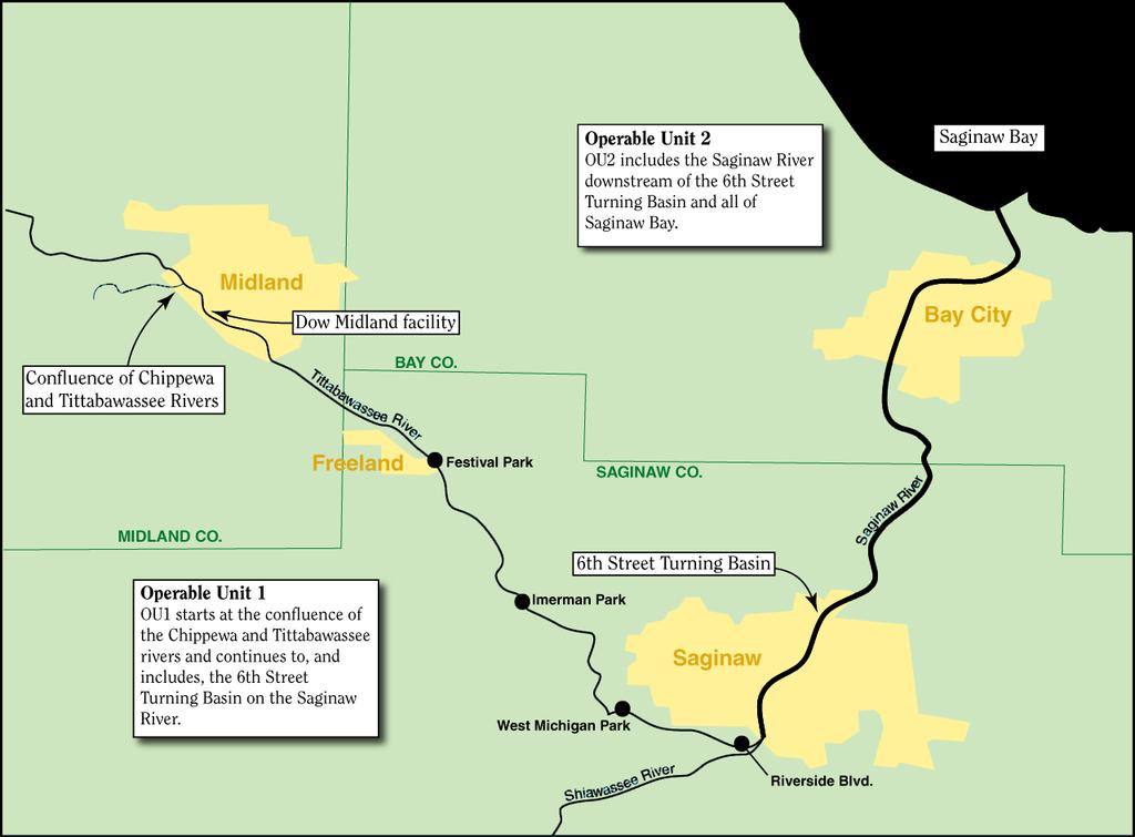
3 The Site
4 Saginaw River 22 mile river beginning at confluence of Tittabawassee and Shiawassee Rivers Drains large watershed River serves industries in Saginaw and Bay City U.S. Army Corps of Engineers (USACE) conducts maintenance dredging in the lower ~17 miles of the river From 6 th Street Turning Basin (SSTB) into Saginaw Bay Saginaw River and Bay are a Great Lakes Area of Concern 4
5 Agenda Background Fundamentals of Sediment Transport Sediment Trap Existing Information Next Steps 5
6 Sediment Inorganic sediment is weathered rock material Sediment is transported, suspended, and deposited with the flow of water Sediment mixes with organic material during transport Sediment particle sizes vary Clay < Silt < Sand < Gravel Tittabawassee River is dominated by sand Saginaw River is dominated by silt and clay Deposited sediment in Saginaw River is mostly sand and silt 6
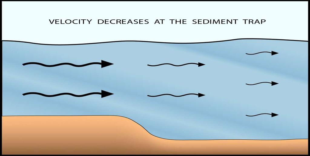
7 Transport Fundamentals In rivers, flowing water is the primary driver of sediment transport Flow rates in rivers are variable As the water flow increases and decreases, water velocity increases and decreases As water velocity changes, so does sediment transport A decrease in water velocity results in a decrease in sediment transport, and particles deposit on the sediment bed Surface particles in most sediment beds are subject to some degree of movement 7
8 Transport Fundamentals (cont.) Larger heavier particles Require more sheer stress (energy) to transport Are first to deposit when velocities decrease Smaller, lighter particles (clays and fine silts) Can suspend in water for a long time Require more time and slower velocities to settle from the water 8
9 Transport Fundamentals What Makes Sediment Particles Move Water flow/velocity results in energy /shear stress that move sediment particles Bed shear stress Describes the hydrodynamic force acting on the sediment bed Bed sediments are transported when the bed shear stress is high enough (greater than critical shear stress) Changes in velocity and bed shear stress changes the rate of transport As the river widens or becomes deeper the velocity and bed shear stress reduces 9
10 SEDIMENT TRANSPORT PROCESSES
11 Transport Fundamentals What Makes Sediment Particles Deposit The opposite of what makes sediment particles move makes them deposit in the river The ability to effectively capture sediment is influenced by Hydrodynamic conditions (flow rates) Type of sediment particles (gravel, sand, silt, clay) Sediments deposit when the kinetic energy (sheer stress) of the water column is reduced Making the river wider and/or deeper reduces kinetic energy in the water column Creates a net-depositional area 11
12 Agenda Background Fundamentals of Sediment Transport Sediment Trap Existing Information Next Steps 12
13 What is a sediment trap? An area in the river designed to catch and hold sediment transported from upstream Effective sediment traps Allow for collection of sediment at a single location Can reduce downstream maintenance dredging requirements in navigation channels 13
14 How does a sediment trap work? Making the river wider or deeper Reduces water velocity, thus reducing energy Velocity = Flow / Area V (m/s) = Q (m 3 /s) / A (m 2 ) Allowing particle deposition In an effective sediment trap Moving particles can deposit Deposited sediment is difficult to transport 14
15 15
16 16
17 Agenda Background Fundamentals of Sediment Transport Sediment Trap Existing Information Next Steps 17
18 Previous Sediment Trap Studies Sediment Trap Assessment, Saginaw River, Michigan, December 2001, USACE/Baird & Associates Sediment Trap Pilot Project Feasibility Study for the Saginaw River, Michigan, July 2008, prepared for ADR Technical Workgroup Sediment Trap Assessment, Saginaw River, Michigan, February 2012, USACE & Baird/URS 18
19 Findings from Sediment Trap Studies USACE / Baird & Associates (2001) Looked at potential traps in the navigation area of the middle and lower Saginaw River Depending on the configuration, a Saginaw River sediment trap is expected to collect a large amount of the incoming suspended sand, and some of the incoming suspended silt Increasing the trap depth and length will improve the trap efficiency for both sand and silt 19
20 Findings from Sediment Trap Studies (cont.) Sediment Trap Pilot Project Feasibility Study (2008) The SSTB effectively traps bedload material that is transported into the basin across a range of flow conditions Due to its larger grain size and its proximity to the sediment bed, a small reduction in velocity accelerates bedload deposition Most of the site-related dioxins are associated with bedload and larger grain size sediment The SSTB has some potential to trap suspended sediment (fine silts and clays), but at a lower capture efficiency compared to bedload 20
21 Findings from Sediment Trap Studies USACE / Baird/URS (2012) (cont.) Looked at potential traps in the upper Saginaw River to prevent transport of material into the navigation area and to reduce dredging costs Sediment traps can efficiently capture sand, but most clay and fine silt will pass into the Bay Increased trap depth increases trapping efficiency and lengthens time needed between maintenance 21

22 River Bed and Surface Water Elevations
23 SSTB Bathymetric Surveys Multiple bathymetric surveys have been conducted at the SSTB to characterize sediment deposition patterns Fall 2006 Dredging Nov 2006 (post-dredging) Sep 2007 Aug 2008 April 2009 (pre-dredging) Summer 2009 Dredging Aug 2009 (post-dredging) May 2010 Jun 2011 (pre-dredging) Fall 2011 Dredging Nov 2011 (post-dredging) March

24 Bathymetric Monitoring 2006 to 2009 Dredging occurred Fall

25 Bathymetric Monitoring 2009 to 2011 Dredging occurred Summer 2009 Dredging occurred Fall
26 SSTB Annual Deposition Rates Net deposition estimated from multibeam bathymetry surveys is variable and influenced by flow conditions Average long-term accumulation rate of ~20,000 CY/yr Findings demonstrate SSTB currently provides an effective trap for incoming sediment when routinely maintained Period Estimated SSTB Volume Dredged by USACE (CY) Fall 2006 Dredge Event ~90,000 Estimated Volume Deposited Within or Upstream of SSTB (CY) Nov Apr ,000 Summer 2009 Dredge Event ~60,000 Aug Jun ,000 Fall 2011 Dredge Event ~40,000
27 Agenda Background Fundamentals of Sediment Transport Sediment Trap Existing Information Next Steps 27
28 Next Steps EPA committed in a letter to the Lone Tree Council to complete an assessment of sediment traps by late 2012 Any actions would require USACE agreement we are engaging in discussions with them 28
29 QUESTIONS?
U.S. Army Corps of Engineers Detroit District. Sediment Trap Assessment Saginaw River, Michigan
 U.S. Army Corps of Engineers Detroit District December 2001 December 2001 This report has been prepared for USACE, Detroit District by: W.F. BAIRD & ASSOCIATES LTD. 2981 YARMOUTH GREENWAY MADISON, WISCONSIN
Quantifying i the GLRI Metric for Annual Sediment Deposition in Great Lakes Harbors:
 USACE 516(e) Annual Meeting Ann Arbor, MI (May 15, 2013) Quantifying i the GLRI Metric for Annual Sediment Deposition in Great Lakes Harbors: A Pilot Evaluation for Toledo Harbor Todd Redder Joe DePinto
Appendix O. Sediment Transport Modelling Technical Memorandum
 Appendix O Sediment Transport Modelling Technical Memorandum w w w. b a i r d. c o m Baird o c e a n s engineering l a k e s design r i v e r s science w a t e r s h e d s construction Final Report Don
Swift Creek Sediment Management Action Plan (SCSMAP)
") Swift Creek Sediment Management Action Plan (SCSMAP) PHASE 2 PROJECT PLAN PROPOSAL Whatcom County Public Works Department 322 N. Commercial Street, Suite 210 Bellingham, WA 98225 (360) 676-6692 June 2013
Swift Creek Sediment Management Action Plan (SCSMAP) PHASE 2 PROJECT PLAN PROPOSAL Whatcom County Public Works Department 322 N. Commercial Street, Suite 210 Bellingham, WA 98225 (360) 676-6692 June 2013
B-1. Attachment B-1. Evaluation of AdH Model Simplifications in Conowingo Reservoir Sediment Transport Modeling
 Attachment B-1 Evaluation of AdH Model Simplifications in Conowingo Reservoir Sediment Transport Modeling 1 October 2012 Lower Susquehanna River Watershed Assessment Evaluation of AdH Model Simplifications
Lower Susquehanna River Reservoir System Proposed Modeling Enhancements
 Lower Susquehanna River Reservoir System Proposed Modeling Enhancements Presented at the Chesapeake Bay Program Scientific and Technical Advisory Committee (STAC) Workshop January 13, 2016 Overview Due
Remaining Capacity in Great Lakes Reservoirs
 US Army Corps of Engineers Detroit District Remaining Capacity in Great Lakes Reservoirs Storage Capacity Behind Great Lakes Dams Field Data and Modeling Motivation for project Project overview Data and
MEMORANDUM. Scott Pickard, CELRB-TD-EH Michael Asquith, CELRB-PM-PM. From: Paul R. Schroeder, Ph.D., PE Earl Hayter, Ph.D. Date: 14 March 2016
 DEPARTMENT OF THE ARMY ENGINEER RESEARCH AND DEVELOPMENT CENTER, CORPS OF ENGINEERS ENVIRONMENTAL LABORATORY WATERWAYS EXPERIMENT STATION, 3909 HALLS FERRY ROAD VICKSBURG, MISSISSIPPI 39180-6199 29 November
STUDY PERFORMANCE REPORT
 STUDY PERFORMANCE REPORT State: Michigan Project No.: F-80-R-8 Study No.: 230702 Title: Effects of sediment traps on Michigan river channels Period Covered: October 1, 2006 to September 30, 2007 Study
Appendix G.19 Hatch Report Pacific NorthWest LNG Lelu Island LNG Maintenance Dredging at the Materials Offloading Facility
 Appendix G.19 Hatch Report Pacific NorthWest LNG Lelu Island LNG Maintenance Dredging at the Materials Offloading Facility Project Memo H345670 To: Capt. David Kyle From: O. Sayao/L. Absalonsen December
Bishopville Prong Study
 Bathymetric and Sediment Assessment in the Bishopville Prong of St. Martin River Darlene V. Wells, Richard A. Ortt, Jr., and Stephen Van Ryswick Funded by MCBP 2011-2012 Implementation Grant Objectives
Tarbela Dam in Pakistan. Case study of reservoir sedimentation
 Tarbela Dam in Pakistan. HR Wallingford, Wallingford, UK Published in the proceedings of River Flow 2012, 5-7 September 2012 Abstract Reservoir sedimentation is a main concern in the Tarbela reservoir
Do you think sediment transport is a concern?
 STREAM RESTORATION FRAMEWORK AND SEDIMENT TRANSPORT BASICS Pete Klingeman 1 What is Your Restoration Project Like? k? Do you think sediment transport is a concern? East Fork Lewis River, WA Tidal creek,
June 2018 Sediments and Dredging at GBR Ports
 June 2018 Sediments and Dredging at GBR Ports Reef 2050 Long Term Sustainability Plan The Great Barrier Reef is over 2000 km long and covers an area of approximately 350,000 square kilometres. It is a
Technical Memorandum No
 Pajaro River Watershed Study in association with Technical Memorandum No. 1.2.10 Task: Evaluation of Four Watershed Conditions - Sediment To: PRWFPA Staff Working Group Prepared by: Gregory Morris and
Reactivation of Klingnau reservoir sidearm: Numerical simulation of sediment release downstream
 River Flow 2014 Schleiss et al. (Eds) 2014 Taylor & Francis Group, London, ISBN 978-1-138-02674-2 Reactivation of Klingnau reservoir sidearm: Numerical simulation of sediment release downstream A. Amini
Redwood City Harbor, California, Navigation Improvement Feasibility Study. Appendix D. Geotechnical Engineering. DRAFT April 2015
 1 Redwood City Harbor, California, Navigation Improvement Feasibility Study Appendix D Geotechnical Engineering DRAFT April 2015 2 Contents 1 Purposes of Report... 3 2 Background... 3 3 References and
REDWOOD VALLEY SUBAREA
 Independent Science Review Panel Conceptual Model of Watershed Hydrology, Surface Water and Groundwater Interactions and Stream Ecology for the Russian River Watershed Appendices A-1 APPENDIX A A-2 REDWOOD
PART 2:! FLUVIAL HYDRAULICS" HYDROEUROPE
 PART 2:! FLUVIAL HYDRAULICS" HYDROEUROPE 2009 1 HYDROEUROPE 2009 2 About shear stress!! Extremely complex concept, can not be measured directly!! Computation is based on very primitive hypotheses that
Sediment and Nutrient Mass Balance Model of ConowingoPool
 Sediment and Nutrient Mass Balance Model of ConowingoPool Mark Velleux and Jim Fitzpatrick HDR Engineering Chesapeake Bay Program Modeling Quarterly Review: August 10, 2016 Model Grid and Spatial Resolution
Sediment Stability in the Lower Passaic River Integration of Multiple Lines of Evidence
 Sediment Stability in the Lower Passaic River Integration of Multiple Lines of Evidence Fourth Passaic River Symposium June 22, 21 Michael Barbara, mab.consulting, LLC Marcia Greenblatt, AECOM John Connolly,
Source Control Early Action Focused Feasibility Study
 Source Control Early Action Focused Feasibility Study Empirical Mass Balance Model Results or the Lower Passaic River Edward A. Garvey, PhD, PG Malcolm Pirnie, Inc. Remedial Options Workgroup Meeting June
Lower Susquehanna River Integrated Sediment & Nutrient Monitoring Program
 Lower Susquehanna River Integrated Sediment & Nutrient Monitoring Program Presented at the Chesapeake Bay Program Scientific and Technical Advisory Committee (STAC) Workshop January 13, 2016 Background
1. The map below shows a meandering river. A A' is the location of a cross section. The arrows show the direction of the river flow.
 1. The map below shows a meandering river. A A' is the location of a cross section. The arrows show the direction of the river flow. Which cross section best represents the shape of the river bottom at
Highland Lake Bathymetric Survey
 Highland Lake Bathymetric Survey Final Report, Prepared For: The Town of Highland Lake 612 Lakeshore Drive Oneonta, AL 35121 Prepared By: Tetra Tech 2110 Powers Ferry Road SE Suite 202 Atlanta, GA 30339
Decline of Lake Michigan-Huron Levels Caused by Erosion of the St. Clair River
 Decline of Lake Michigan-Huron Levels Caused by Erosion of the St. Clair River W.F. & Associates Coastal Engineers (in association with Frank Quinn) April 13, 2005 Outline Problem Definition Understanding
 Red River Flooding June 2015 Caddo and Bossier Parishes Presented by: Flood Technical Committee Where the Rain Falls Matters I-30 versus I-20 I-20 Backwater and Tributary Floods (Localized) 2016 Flood
Great Lakes Update. Volume 191: 2014 January through June Summary. Vol. 191 Great Lakes Update August 2014
 Great Lakes Update Volume 191: 2014 January through June Summary The U.S. Army Corps of Engineers (USACE) monitors the water levels of each of the Great Lakes. This report provides a summary of the Great
Primary Structures in Sedimentary Rocks. Engr. Sultan A. Khoso
 Primary Structures in Sedimentary Rocks Engr. Sultan A. Khoso Sedimentary rocks Sedimentary rocks are those rocks which are formed by the weathered sediments of pre existing rocks (igneous or metamorphic
Coastal Sediment Properties and Longshore Sediment Transport
 Coastal Sediment Properties and Longshore Sediment Transport Julie Rosati Julie.D.Rosati@erdc.usace.army.mil 601-634-3005 Coastal Planning Course Lesson #8 Tuesday 8:00-9:00 am CEM III-1, III-2 1. Coastal
Strategies for managing sediment in dams. Iwona Conlan Consultant to IKMP, MRCS
 Strategies for managing sediment in dams Iwona Conlan Consultant to IKMP, MRCS 1 Sediment trapping by dams Active storage capacity Dead storage coarse material (bed load) Fine materials (suspension) Francis
An Update to EPA s Conceptual Site Model for the Lower Passaic River: An Examination of the Most Recent Results
 An Update to EPA s Conceptual Site Model for the ower Passaic River: An Examination of the Most Recent Results Edward A. arvey, Alice Yeh 2, Solomon bondo-tugbawa, Juliana Atmadja, John Kern 3, AmyMarie
River Model (Delft3D)
") A Short River Model (Delft3D) & DIVERSION ANALYSIS presented by Nina J. Reins, PE, PhD, PMP State of the Coast May 30-June 1, 2018 Overview of Presentation Problem Statement & Background Analysis Key Findings
A Short River Model (Delft3D) & DIVERSION ANALYSIS presented by Nina J. Reins, PE, PhD, PMP State of the Coast May 30-June 1, 2018 Overview of Presentation Problem Statement & Background Analysis Key Findings
RESULTS FROM THE TEXAS COASTAL SEDIMENT SOURCES: A GENERAL EVALUATION STUDY
 RESULTS FROM THE TEXAS COASTAL SEDIMENT SOURCES: A GENERAL EVALUATION STUDY JUAN MOYA KELSEY CALVEZ CRIS WEBER ANTHONY RISKO *KEVIN FRENZEL FREESE AND NICHOLS, INC. COASTAL AND WATERWAYS GROUP OBJECTIVES
MaxDepth Aquatics, Inc.
 MaxDepth Aquatics, Inc. Bathymetry of Mirror Pond From Newport Bridge to Galveston Bridge Prepared for the City of Bend By Joseph Eilers & Benn Eilers MaxDepth Aquatics, Inc. Bend, OR June 2005 INTRODUCTION
Sedimentation in the Nile River
 Advanced Training Workshop on Reservoir Sedimentation Sedimentation in the Nile River Prof. Dr. Abdalla Abdelsalam Ahmed 10-16 Oct. 2007, IRTCES, Beijing, China CWR,Sudan 1 Water is essential for mankind
Development and application of demonstration MIKE 21C morphological model for a bend in Mekong River
 Development and application of demonstration MIKE 21C morphological model for a bend in Mekong River September 2015 0 Table of Contents 1. Introduction... 2 2. Data collection... 3 2.1 Additional data...
Erosion Surface Water. moving, transporting, and depositing sediment.
 + Erosion Surface Water moving, transporting, and depositing sediment. + Surface Water 2 Water from rainfall can hit Earth s surface and do a number of things: Slowly soak into the ground: Infiltration
Great Lakes Dam Capacity Study
 Great Lakes Dam Capacity Study Project Team: USACE, Detroit District Wayne State University, Detroit, Michigan Great Lakes Environmental Center, Traverse City, Michigan BUILDING STRONG Study Objectives
2015 Fall Conditions Report
 2015 Fall Conditions Report Prepared by: Hydrologic Forecast Centre Date: December 21 st, 2015 Table of Contents Table of Figures... ii EXECUTIVE SUMMARY... 1 BACKGROUND... 2 SUMMER AND FALL PRECIPITATION...
U.S. Army Corps of Engineers Detroit District. Boardman River SIAM Modeling Base-case Scenario
 U.S. Army Corps of Engineers Detroit District Boardman River SIAM Modeling Base-case Scenario May 2009 Boardman River SIAM Modeling Base-case Scenario Report Prepared for U.S. Army Corps of Engineers
Final Report. Prepared for. American Rivers, California Trout, Friends of the River and Trout Unlimited
 A of the Potential Downstream Sediment Deposition Following the Removal of Iron Gate, Copco, and J.C. Boyle Dams, Klamath River, CA Final Report Prepared for American Rivers, California Trout, Friends
Great Lakes Tributary Modeling: Canaseraga Creek Watershed
 Great Lakes Tributary Modeling: Canaseraga Creek Watershed SWAT Model Authority: Section 516(e) of WRDA 1996 US Army Corps of Engineers Canaseraga Creek Project Location - Encompasses portions of Livingston,
HEC-RAS Reservoir Transport Simulation of Three Reservoirs in the Lower Susquehanna River Basin. Mike Langland and Ed Koerkle
 HEC-RAS Reservoir Transport Simulation of Three Reservoirs in the Lower Susquehanna River Basin Mike Langland and Ed Koerkle Topics Background / Project Objectives Data Selection - Sediment and Geometric
Colorado River sediment transport 1. Natural sediment supply limitation and the influence of Glen Canyon Dam
 WATER RESOURCES RESEARCH, VOL. 36, NO. 2, PAGES 515 542, FEBRUARY 2000 Colorado River sediment transport 1. Natural sediment supply limitation and the influence of Glen Canyon Dam David J. Topping U.S.
Appendix I. Dredged Volume Estimates. Draft Contractor Document: Subject to Continuing Agency Review
 Appendix I Dredged Volume Estimates Draft Contractor Document: Subject to Continuing Agency Review Interoffice Correspondence Date: April 6, 2007 To: L. Bossi (WHI) Copy: S. Thompson (WHI), B. Fidler (NNJ)
STUDY GUIDE FOR CONTENT MASTERY. Surface Water Movement
 Surface Water SECTION 9.1 Surface Water Movement In your textbook, read about surface water and the way in which it moves sediment. Complete each statement. 1. An excessive amount of water flowing downslope
How to predict the sedimentological impacts of reservoir operations?
 ICSE 212 How to predict the sedimentological impacts of reservoir operations? E. Valette EDF CIH eric.valette@edf.fr M. Jodeau EDF R&D LNHE magali.jodeau@edf.fr Presentation of the numerical code Courlis
Assessment of the Hood River Delta Hood River, Oregon
 Assessment of the Hood River Delta Hood River, Oregon Pacific Northwest Waterways Association Annual Meeting October 13, 2010 Michael McElwee, Executive Director Port of Hood River Overview U.S. Army Corps
Surface Water and Stream Development
 Surface Water and Stream Development Surface Water The moment a raindrop falls to earth it begins its return to the sea. Once water reaches Earth s surface it may evaporate back into the atmosphere, soak
Influence of the Major Drainages to the Mississippi River and Implications for System Level Management
 Influence of the Major Drainages to the Mississippi River and Implications for System Level Management Brian M. Vosburg Geologist Louisiana Coastal Protection and Restoration Authority brian.vosburg@la.gov
MENOMONEE RIVER SEDIMENT TRANSPORT MODELING SYSTEM FINAL REPORT
 MENOMONEE RIVER SEDIMENT TRANSPORT MODELING SYSTEM FINAL REPORT Prepared for: U.S. ARMY CORPS OF ENGINEERS DETROIT DISTRICT BOX 127 DETROIT, MICHIGAN 48231 Prepared by: W.F. BAIRD & ASSOCIATES, LTD. 2981
Walnut Creek Sedimentation Study
 Walnut Creek Sedimentation Study January 10, 2012 Prepared for: U.S. Army Corps of Engineer Sacramento District 1325 J Street Sacramento, CA 95814-2922 Prepared by: Ronald R. Copeland, Ph.D., P.E. Mobile
Imagine the result Sediment Sampling Plan. 1½-Mile Reach of the Housatonic River. General Electric Company Pittsfield, Massachusetts
 Imagine the result General Electric Company Pittsfield, Massachusetts 2012 Sediment Sampling Plan 1½-Mile Reach of the Housatonic River March 2012 2012 Sediment Sampling Plan 1½-Mile Reach of the Housatonic
Erosion Rate is a Function of Erodibility and Excess Shear Stress = k ( o - c ) From Relation between Shear Stress and Erosion We Calculate c and
 From Relation between Shear Stress and Erosion We Calculate c and") Equilibrium, Shear Stress, Stream Power and Trends of Vertical Adjustment Andrew Simon USDA-ARS, Oxford, MS asimon@msa-oxford.ars.usda.gov Non-Cohesive versus Cohesive Materials Non-cohesive: sands and
Equilibrium, Shear Stress, Stream Power and Trends of Vertical Adjustment Andrew Simon USDA-ARS, Oxford, MS asimon@msa-oxford.ars.usda.gov Non-Cohesive versus Cohesive Materials Non-cohesive: sands and
Cohesive sediment erosion and the Vectrino II. Peter J. Rusello DeFrees Hydraulics Laboratory Cornell University (also with NortekUSA)
") Cohesive sediment erosion and the Vectrino II Peter J. Rusello DeFrees Hydraulics Laboratory Cornell University (also with NortekUSA) http://www.flickr.com/photos/rabbit75/5191473522/ Images taken from
Cohesive sediment erosion and the Vectrino II Peter J. Rusello DeFrees Hydraulics Laboratory Cornell University (also with NortekUSA) http://www.flickr.com/photos/rabbit75/5191473522/ Images taken from
Habitat Suitability for Forage Fishes in Chesapeake Bay
 Habitat Suitability for Forage Fishes in Chesapeake Bay Aug 2017 Jul 2019 Mary C Fabrizio Troy D Tuckey Aaron J Bever Michael L MacWilliams 21 June 2018 Photo: Chesapeake Bay Program Motivation Production
Great Lakes Update. Volume 188: 2012 Annual Summary
 Great Lakes Update Volume 188: 2012 Annual Summary Background The U.S. Army Corps of Engineers (USACE) tracks the water levels of each of the Great Lakes. This report highlights hydrologic conditions of
Connec&ng phosphorus loads to cyanobacteria biomass using the Western Lake Erie Ecosystem Model
 Connec&ng phosphorus loads to cyanobacteria biomass using the Western Lake Erie Ecosystem Model John F. Bra?on Edward M. Verhamme, Todd M. Redder, Derek A. Schlea, Jeremy Grush, and Joseph DePinto Western
Illinois State Water Survey Division
 Illinois State Water Survey Division SURFACE WATER SECTION SWS Miscellaneous Publication 108 SEDIMENT YIELD AND ACCUMULATION IN THE LOWER CACHE RIVER by Misganaw Demissie Champaign, Illinois June 1989
Anderson-Ketron PSDDA Disposal Site Fate and Transport Modeling
 Pierce County Washington Anderson-Ketron PSDDA Disposal Site Fate and Transport Modeling Design Memorandum September 2014 Table of Contents 1 Introduction... 3 1.1 Purpose and Scope... 3 1.2 Project Description:
Upper Mississippi River Basin Environmental Management Program Workshop
 Presentation to the Upper Mississippi River Basin Environmental Management Program Workshop by Michael Rodgers River Engineer US Army Corps of Engineers, St. Louis District August 17, 2007 Engineering
Development, Testing and Application of the Multi-Block LTFATE Hydrodynamic and Sediment Transport Model
 Development, Testing and Application of the Multi-Block LTFATE Hydrodynamic and Sediment Transport Model Earl Hayter Environmental Lab October 25, 2012 LTFATE Multi-Block Hydrodynamic, Water Quality and
FORECAST-BASED OPERATIONS AT FOLSOM DAM AND LAKE
 FORECAST-BASED OPERATIONS AT FOLSOM DAM AND LAKE 255 237 237 237 217 217 217 200 200 200 0 163 131 Bridging the Gap163Conference 255 0 132 255 0 163 122 The Dana on Mission Bay San Diego, CA January 28,
A STUDY OF LOCAL SCOUR AT BRIDGE PIERS OF EL-MINIA
 A STUDY OF LOCAL SCOUR AT BRIDGE PIERS OF EL-MINIA Dr. Gamal A. Sallam 1 and Dr. Medhat Aziz 2 ABSTRACT Bridges are critical structures that require a substantial investment to construct and serve an important
Stickney Avenue Depositional Zone (SADZ) Investigation
 Investigation") The Ottawa River: A Report to the Community Stickney Avenue Depositional Zone (SADZ) Investigation May 22, 2007 Presented by: Scott Bell, P.E., BCEE (LimnoTech) Kelly Bensman (Hull & Associates) SADZ Location
The Ottawa River: A Report to the Community Stickney Avenue Depositional Zone (SADZ) Investigation May 22, 2007 Presented by: Scott Bell, P.E., BCEE (LimnoTech) Kelly Bensman (Hull & Associates) SADZ Location
HYDROLOGIC AND WATER RESOURCES EVALUATIONS FOR SG. LUI WATERSHED
 HYDROLOGIC AND WATER RESOURCES EVALUATIONS FOR SG. LUI WATERSHED 1.0 Introduction The Sg. Lui watershed is the upper part of Langat River Basin, in the state of Selangor which located approximately 20
Great Lakes Update. Volume 193: 2015 January through June Summary. Vol. 193 Great Lakes Update August 2015
 Great Lakes Update Volume 193: 2015 January through June Summary The U.S. Army Corps of Engineers (USACE) monitors the water levels of each of the Great Lakes. This report provides a summary of the Great
Simulating Sediment Transport in the Patapsco River following Dam Removal with Dam Removal Express Assessment Model-1 (DREAM-1)
") Simulating Sediment Transport in the Patapsco River following Dam Removal with Dam Removal Express Assessment Model-1 (DREAM-1) Prepared for Inter-Fluve 362 Atwood Ave., Suite 3 Madison, WI 53714 www.interfluve.com
Simulating Sediment Transport in the Patapsco River following Dam Removal with Dam Removal Express Assessment Model-1 (DREAM-1) Prepared for Inter-Fluve 362 Atwood Ave., Suite 3 Madison, WI 53714 www.interfluve.com
Detroit 516 Activities
 Detroit 516 Activities Dam Capacity Study Sediment Workshop in Traverse City START 2.0 Saginaw River Study Dam Capacity Study A progress report Outline Study Objective (Why are we doing this?) Reservoir
PHYSICAL GEOGRAPHY. By Brett Lucas
 PHYSICAL GEOGRAPHY By Brett Lucas FLUVIAL PROCESSES Fluvial Processes The Impact of Fluvial Processes on the Landscape Streams and Stream Systems Stream Channels Structural Relationships The Shaping and
Muck. Kevin Henderson, P.E. Evergreen Engineering, Inc. Presentation to Rivers Coalition 9/29/16
 Muck Kevin Henderson, P.E. Evergreen Engineering, Inc. Presentation to Rivers Coalition 9/29/16 LITERATURE REVIEW Schropp (1994) defined muck sediments as sediment with greater than 60% silts and clays,
Island Design. UMRS EMP Regional Workshop. Presentation for the
 Island Design Presentation for the UMRS EMP Regional Workshop by Jon Hendrickson Hydraulic Engineer Regional Technical Specialist, Water Quality and Habitat Restoration August 17 19, 2005 Project Delivery
Waterbury Dam Disturbance Mike Fitzgerald Devin Rowland
 Waterbury Dam Disturbance Mike Fitzgerald Devin Rowland Abstract The Waterbury Dam was completed in October 1938 as a method of flood control in the Winooski Valley. The construction began in April1935
1. Base your answer to the following question on the map below, which shows the generalized bedrock of a part of western New York State.
 1. Base your answer to the following question on the map below, which shows the generalized bedrock of a part of western New York State. 3. The table below describes the deposits that an observer saw while
Assessment of Water and Sediment Patterns within Prado Basin
 APPENDIX A Assessment of Water and Sediment Patterns within Prado Basin APPENDIX A Submitted To: Orange County Water District 18700 Ward Street Fountain Valley, California 92708 USA Submitted By: Golder
Appendix G.18 Hatch Report Pacific NorthWest LNG Lelu Island LNG Potential Impacts of the Marine Structures on the Hydrodynamics and Sedimentation
 Appendix G.18 Hatch Report Pacific NorthWest LNG Lelu Island LNG Potential Impacts of the Marine Structures on the Hydrodynamics and Sedimentation Patterns Project Memo H345670 To: Capt. David Kyle From:
Technical Memorandum
 2855 Telegraph Avenue, Suite 4, Berkeley, CA 9475, Phone (51) 848-898, Fax (51) 848-8398 Technical Memorandum Date: September 6, 27 To: Mr. Michael Bowen, Project Manager From: Yantao Cui, Ph.D., Hydraulic
Swift Creek Sediment Management Action Plan (SCSMAP)
") Swift Creek Sediment Management Action Plan (SCSMAP) PHASE 3 PROJECT PLAN PROPOSAL Whatcom County Public Works Department 322 N. Commercial Street, Suite 210 Bellingham, WA 98225 (360) 676-6692 June 2013
Swift Creek Sediment Management Action Plan (SCSMAP) PHASE 3 PROJECT PLAN PROPOSAL Whatcom County Public Works Department 322 N. Commercial Street, Suite 210 Bellingham, WA 98225 (360) 676-6692 June 2013
N 2 3. Lake Huron. St. Clair River. Black River Assessment. Figure 1. Major tributaries to the Black River. 1. Berry Drain 2. Elk Creek.
 1. Berry Drain 2. Elk Creek Deckerville 3. Arnot Creek 4. Black Creek 5. Silver Creek 6. Plum Creek 7. Mill Creek 1 Sandusky Carsonville 8. Stocks Creek Applegate N 2 3 Croswell Peck 0 5 10 Brown City
HISTORY OF CONSTRUCTION FOR EXISTING CCR SURFACE IMPOUNDMENT PLANT GASTON ASH POND 40 CFR (c)(1)(i) (xii)
(1)(i) (xii)") HISTORY OF CONSTRUCTION FOR EXISTING CCR SURFACE IMPOUNDMENT PLANT GASTON ASH POND 40 CFR 257.73(c)(1)(i) (xii) (i) Site Name and Ownership Information: Site Name: E.C. Gaston Steam Plant Site Location:
HISTORY OF CONSTRUCTION FOR EXISTING CCR SURFACE IMPOUNDMENT PLANT GASTON ASH POND 40 CFR 257.73(c)(1)(i) (xii) (i) Site Name and Ownership Information: Site Name: E.C. Gaston Steam Plant Site Location:
SCOPE OF PRESENTATION STREAM DYNAMICS, CHANNEL RESTORATION PLANS, & SEDIMENT TRANSPORT ANALYSES IN RELATION TO RESTORATION PLANS
 DESIGN METHODS B: SEDIMENT TRANSPORT PROCESSES FOR STREAM RESTORATION DESIGN PETER KLINGEMAN OREGON STATE UNIVERSITY CIVIL ENGINEERING DEPT., CORVALLIS 2 ND ANNUAL NORTHWEST STREAM RESTORATION DESIGN SYMPOSIUM
Sessom Creek Sand Bar Removal HCP Task 5.4.6
 Sessom Creek Sand Bar Removal HCP Task 5.4.6 Prepared by: Dr. Thomas Hardy Texas State University Dr. Nolan Raphelt Texas Water Development Board January 6, 2013 DRAFT 1 Introduction The confluence of
Sediment and sedimentary rocks Sediment
 Sediment and sedimentary rocks Sediment From sediments to sedimentary rocks (transportation, deposition, preservation and lithification) Types of sedimentary rocks (clastic, chemical and organic) Sedimentary
State Water Survey Division SURFACE WATER SECTION
 State Water Survey Division SURFACE WATER SECTION AT THE UNIVERSITY OF ILLINOIS Illinois Department of Energy and Natural Resources SWS Miscellaneous Publication 88 SEDIMENTATION OF POOL 19 ON THE MISSISSIPPI
2. PRESENT CONDITION OF THE RESERVOIR 2.1 View of Wonogiri Reservoir (1/3)
") 2.1 View of Wonogiri Reservoir (1/3) Wonogiri dam abutment on the left side of dam Spillway forebay on thet left side of dam Bank erosion around Wonogiri reservoir. Wonogiri Dam view from chersonese. An
2.1 View of Wonogiri Reservoir (1/3) Wonogiri dam abutment on the left side of dam Spillway forebay on thet left side of dam Bank erosion around Wonogiri reservoir. Wonogiri Dam view from chersonese. An
Aquatic Transfer Facility (ATF) San Pablo Bay (SPB) Proposed Region of ATF. Proposed Seabed Pipeline
 San Pablo Bay (SPB) Proposed Region of ATF. Proposed Seabed Pipeline") Aquatic Transfer Facility (ATF) San Pablo Bay (SPB) Proposed Region of ATF Proposed Seabed Pipeline Technical Studies An Overview Scope: Provide background and new scientific information and analysis for
Aquatic Transfer Facility (ATF) San Pablo Bay (SPB) Proposed Region of ATF Proposed Seabed Pipeline Technical Studies An Overview Scope: Provide background and new scientific information and analysis for
Folsom Dam Water Control Manual Update Joint Federal Project, Folsom Dam
 Folsom Dam Water Control Manual Update Joint Federal Project, Folsom Dam Public Workshop May 25, 2016 Sacramento Library Galleria 828 I Street, Sacramento, CA US Army Corps of Engineers BUILDING STRONG
Ontonagon River Assessment FIGURES
 FIGURES 95 Major Streams and Lakes 1 Pelton Creek 36 Imp Creek 2 Slate River 37 Imp Lake 3 Marshall Creek 38 Marion Lake 4 Trout Brook 39 Tamarack Lake 5 Lake Gogebic 40 Tamarack River 6 West Branch Ontonagon
CR AAO Bridge. Dead River Flood & Natural Channel Design. Mitch Koetje Water Resources Division UP District
 CR AAO Bridge Dead River Flood & Natural Channel Design Mitch Koetje Water Resources Division UP District Old County Road AAO Bridge Map courtesy of Marquette County Silver Lake Basin McClure Basin
THE QUATERNARY GEOLOGY OF NEWARK BAY AND KILL VAN KULL CHANNEL, NEW YORK AND NEW JERSEY. and
 THE QUATERNARY GEOLOGY OF NEWARK BAY AND KILL VAN KULL CHANNEL, NEW YORK AND NEW JERSEY Stephanie Beda, W. Bruce Ward, William Murphy, Robert Fleming, Gary Fleming, Beckett Boyd Earthworks LLC 27 Glen
PTM: A Lagrangian Particle Tracking Model. Joseph Gailani
 PTM: A Lagrangian Particle Tracking Model Joseph Gailani Joe.Z.Gailani@usace.army.mil OUTLINE Motivation for sediment/constituent modeling system Objectives of modeling system Description of PTM PTM Example
Calculation of Stream Discharge Required to Move Bed Material
 Calculation of Stream Discharge Required to Move Bed Material Objective: Students will map two sections of a stream and calculate the depth, velocity, and discharge of flows required to move the stream
L.O: SLOWING STREAMS DEPOSIT (SORT) SEDIMENT HORIZONTALLY BY SIZE.
 SEDIMENT HORIZONTALLY BY SIZE.") L.O: SLOWING STREAMS DEPOSIT (SORT) SEDIMENT HORIZONTALLY BY SIZE. 1. Base your answer to the following question on the profile shown below, which shows the pattern of horizontal sorting produced at a
L.O: SLOWING STREAMS DEPOSIT (SORT) SEDIMENT HORIZONTALLY BY SIZE. 1. Base your answer to the following question on the profile shown below, which shows the pattern of horizontal sorting produced at a
January 25, Summary
 January 25, 2013 Summary Precipitation since the December 17, 2012, Drought Update has been slightly below average in parts of central and northern Illinois and above average in southern Illinois. Soil
(3) Sediment Movement Classes of sediment transported
 Sediment Movement Classes of sediment transported") 9/17/15 (3) Sediment Movement Classes of sediment transported Dissolved load Suspended load Important for scouring algae Bedload (5-10% total load) Moves along bed during floods Source of crushing for
9/17/15 (3) Sediment Movement Classes of sediment transported Dissolved load Suspended load Important for scouring algae Bedload (5-10% total load) Moves along bed during floods Source of crushing for
Numerical modeling of sediment flushing from Lewis and Clark Lake
 University of Nebraska - Lincoln DigitalCommons@University of Nebraska - Lincoln US Army Research U.S. Department of Defense 2013 Numerical modeling of sediment flushing from Lewis and Clark Lake Jungkyu
Folsom Dam Water Control Manual Update Joint Federal Project, Folsom Dam
 Folsom Dam Water Control Manual Update Joint Federal Project, Folsom Dam Public Workshop May 28, 2015 Library Galleria 828 I Street, Sacramento, CA US Army Corps of Engineers BUILDING STRONG WELCOME &
Analysis of Sedimentation in Wonogiri Reservoir
 Journal of the Civil Engineering Forum Vol. 2 No. 1 (January 2016) Analysis of Sedimentation in Wonogiri Reservoir Tri Joko Inti Budi Santosa Large River Basin Organization of Bengawan Solo, Surakarta,
EAGLES NEST AND PIASA ISLANDS
 EAGLES NEST AND PIASA ISLANDS HABITAT REHABILITATION AND ENHANCEMENT PROJECT MADISON AND JERSEY COUNTIES, ILLINOIS ENVIRONMENTAL MANAGEMENT PROGRAM ST. LOUIS DISTRICT FACT SHEET I. LOCATION The proposed