HEC-RAS Reservoir Transport Simulation of Three Reservoirs in the Lower Susquehanna River Basin. Mike Langland and Ed Koerkle
|
|
|
- Ethan Little
- 6 years ago
- Views:
Transcription
1 HEC-RAS Reservoir Transport Simulation of Three Reservoirs in the Lower Susquehanna River Basin Mike Langland and Ed Koerkle
2 Topics Background / Project Objectives Data Selection - Sediment and Geometric Input Data Sediment transport calibration / simulation Model results / issues
3 Background USGS collected bathymetry and cores in 1990, 1993, 1996, 2001, and 2008 Document change in sediment storage capacity and size composition Previous USGS HEC-6 Model (1995) Remaining Capacity Implications - Chesapeake Watershed TMDL - PA/NY reduce more to meet goals
4 Changes in Bathymetry with Time only 10-15% of original volume remains to fill to capacity

5 Sediment inputs have been decreasing (about 2/3 less)
6 Objectives Construct, calibrate, and validate a 1-D sediment model for the entire Reservoir system (~33 miles) GOAL - Simulate the loads in and out, bed-form change, and particle size distribution Product - Produce input boundary condition files for Conowingo Reservoir for USACE 2-D model
7 Definitions 1-D sediment model model either erodes OR deposits, not both on same transect Shear stress (SS) force of water acting on the channel sides and bed (different for each particle size) model can only have one) Critical Shear Stress (CSS) shear stress required to mobilize sediments (model can only input one value) Generally, if SS < CSS, then deposition, if SS = CSS, then equilibrium, if SS > SCC, then degradation (scour)
8 Susquehanna River Reservoirs Model Simulation area (~33 m)
9 HEC-RAS Model 3 main steps 1) Prepare Input data sediment and flow 2) Construct Geometric and Hydraulic framework 3) Calibrate to observed data
10 Input Data Sediment - transport curves or estimated daily sediment loads and core data Flow rating curve or actual daily flow data
11 Sediment Transport Curves *Transport curves yielded low mass, used actual sediment data
12 Bed Material Particle Size (cores) Generally, more sand, less silt and clay as upstream distance increases. (19 locations in Conowingo) DOWN STREAM UPSTREAM
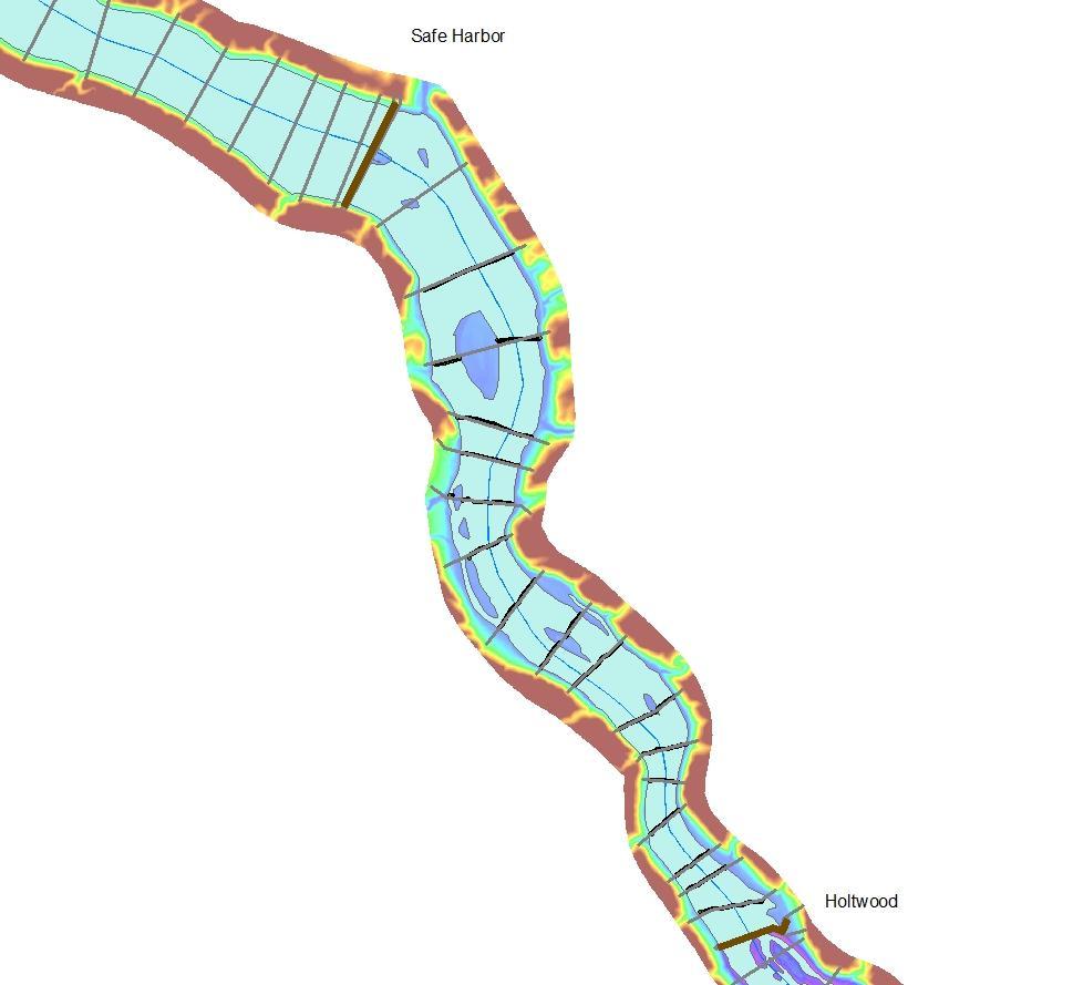
13 Bed Material Grouping (cores) Safe Harbor 4 groups Based on particle size and bed thickness Assigned average shear stress based on USACE Sediment Flume data Holtwood 5 groups Conowingo 5 groups
14 HEC-RAS Model 3 main steps 1) Prepare Input data sediment and flow 2) Construct Geometric and Hydraulic framework 3) Calibrate to observed data
15 Model Geometry Geometric Options : Adapt previous HEC-6 model (USGS, 1995) Convert HEC-2 (FIS) model to RAS sediment model Construct new RAS sediment model
16 Options : Adapt HEC-6 model ( USGS, 1995) Performed poorly, no digital files Convert HEC-2 (FIS) model to RAS sed model Covers 75% of reach, XS stationing errors, no XS bathymetry, and poor alignment current bathymetry Construct new RAS model Alignment of XS cut lines with current bathymetry Model geometry better suited for sediment model (i.e., no structures, fewer XS) Use Lidar-derived topography for channel banks
17 Flood Insurance Study Cross-sections No transect data
18 Options : Adapt HEC-6 model ( USGS, 1995) Performed poorly, no digital files Convert HEC-2 (FIS) model to RAS sed model Covers 75% of reach, XS stationing errors, no XS bathymetry, and poor alignment current bathymetry Construct new RAS model Alignment of XS cut lines with current bathymetry Model geometry better suited for sediment model (i.e., no structures, fewer XS) Use Lidar-derived topography for channel banks
19
20 Final Model Cross-sections 34 in Conowingo 18 In Holtwood 28 in Safe Harbor 80 X-sections Avg one X-section every 0.4 mile SU SQ LSUS Holtwood Dam Safe Harbor Dam Conowingo Dam
21 Hydraulics Hydraulic Options : Discharge Rating Curve Actual daily value discharge Gate and Spillway Simulation
22 Elevation (ft) Gate Representation (Safe Harbor) LSusqReservSed Plan: SedRunInitial 10/3/2012 Safe Harbor Dam Legend EG 01Jan WS 01Jan Ground Ineff Bank Sta Station (ft)
23 Elevation (ft) Reservoir System Hydraulic Representation LSusqReservSed Plan: SedRunInitial 10/19/2012 SUSQ LSUS Safe Harbor Dam Holtwood Dam Legend EG 09Sep WS 09Sep Cri t 09Sep EG 01Jan WS 01Jan Cri t 01Jan Ground Conowingo Dam Mai n Channel Distance (ft)
24 HEC-RAS Model 3 main steps 1) Prepare Input data sediment and flow 2) Construct Geometric and Hydraulic framework 3) Calibrate to observed data
25 Simulation targets ( calibration data) Reasonable estimates of particle size distributions and sediment depth s in the Reservoir System. Bathymetry from 2008 and 2011 surveys Daily streamflow and sediment loads for More detailed sediment load from Sept flood (Tropical storm Lee)
26 Model Calibration Issues Bathymetry data indicates both deposition and scour in same X-Section, 1-D model simulates only one occurrence Modeled fall velocity (silts and clays) about 2X lower (lack of deposition) then expected from literature values and 2-D model, and could not adjust values Model only allows one critical shear stress value, SEDFLUME data indicates wide variability (8x) Increasing the critical shear resulted in an increase in scour (contradictory effect)
27 GSE 2011 XC21
28 Results Model Development Due to uncertainty (fall-velocity and bed sorting), built and verified 2 models, one net depositional one net scour Both boundary condition outputs delivered to Steve (USACE) for 2-D model Depositional model recommended and produced best overall results Scour model performed better for T.S. Lee and other short-term high flow scour events Allows for range in uncertainty
29 ll (tons) HEC-RAS Deposition Model (Transport Function Laursen (Copeland), Sorting Method Exner5, Fall Velocity Method Ruby, Cohesive shear lbs/sqft)) SUSQ-LSUS 31Dec :00: Conowingo Dam Holtwood Dam Safe Harbor Dam 31D T.S. Lee September 7-13, 2011 Mass In 22.3 M tons Mass In 9.95 M tons Mass Out 20.2 M tons Mass Out 9.57 M tons Difference 2.1 M tons deposition Difference <1 M tons deposition , ,000 Distance Upstream (ft)
30 31Dec :00:00 HEC-RAS Deposition Model Bed Elevation Change (ft) 31Dec :00:00 Legend Safe Harbor Dam Holtwood Dam Conowingo Dam
31 t Cum: All (tons) HEC-RAS Scour Model (Transport Function Laursen (Copeland), Sorting Method - Active Layer, Fall Velocity Method Van Rijn, Cohesive shear lbs/sq ft)) SUSQ-LSUS 31Dec :00: Conowingo Dam 31DEC2 Holtwood Dam Safe Harbor Dam T.S. Lee September 7-13, 2011 Mass In 22.3 M tons Mass In 9.9 M tons Mass Out 25.2 Mass Out 11.4 M tons Difference 2.9 M tons scour Difference 1.5 M tons scour , ,000 Distance Upstream (ft)
32 31Dec :00:00 31Dec :00:00 HEC-RAS Scour Model Bed Elevation Change (ft) Safe Harbor Dam Legend Holtwood Dam Conowingo Dam
33 Model Results Sediment Transport (tons) Loads (tons) HEC-RAS (depositional) CY difference TS Lee (Sept 7-13, 2011) difference Marietta IN 22,300,000 9,950,000 Conowingo IN 22,100, ,000 10,100, ,000 Conowingo OUT 20,200,000 2,100,000 9,570, ,000 HEC-RAS (scour) Marietta IN 22,300,000 9,950,000 Conowingo IN 24,400,000-2,100,000 10,300, ,000 Conowingo OUT 25,200, ,000 11,400,000-1,100,000 USGS ESTIMATOR Marietta IN 22,300, ,950, Conowingo OUT 21,100,000 1,200,000 13,500,000-3,500,000 WRTDS (B. Hirsch) Conowingo OUT WY ,500, TS Lee 18,800,000 --
34 Model results Particle Size HEC-RAS (depositional) Particle Size TS Lee Historic Particle Size Sand/Silt/Clay Sand/Silt/Clay Sand/Silt/Clay Marietta IN 10 / 47 / / 47 / 42 9 / 47 / 44 Conowingo IN 3 / 47 / 50 5 / 50 / 45 n/a Conowingo OUT 1 / 32 / 67 2 / 50 / 48 1 / 51 / 48 HEC-RAS (Scour) TS Lee Historic P.S. Sand/Silt/Clay Sand/Silt/Clay Sand/Silt/Clay Marietta IN 10 / 47 / / 47 / 42 9 / 47 / 44 Conowingo IN 2 / 48 / 50 5 / 51 / 44 n/a Conowingo OUT 1 / 45 / 54 2 / 52 / 46 1 / 51 / 48 Minor differences between models Good correspondence with historic particle size
35 Summary HEC-RAS generally not condusive for cohesive (silts/clays) simulations The 2 models provide a range of uncertainty in the boundary condition files Estimated total sediment transport most likely underestimated but reasonable Both models indicate upper 2 reservoirs still play a role in sediment transport
Lower Susquehanna River Reservoir System Proposed Modeling Enhancements
 Lower Susquehanna River Reservoir System Proposed Modeling Enhancements Presented at the Chesapeake Bay Program Scientific and Technical Advisory Committee (STAC) Workshop January 13, 2016 Overview Due
Sediment and Nutrient Mass Balance Model of ConowingoPool
 Sediment and Nutrient Mass Balance Model of ConowingoPool Mark Velleux and Jim Fitzpatrick HDR Engineering Chesapeake Bay Program Modeling Quarterly Review: August 10, 2016 Model Grid and Spatial Resolution
Lower Susquehanna River Integrated Sediment & Nutrient Monitoring Program
 Lower Susquehanna River Integrated Sediment & Nutrient Monitoring Program Presented at the Chesapeake Bay Program Scientific and Technical Advisory Committee (STAC) Workshop January 13, 2016 Background
LAKE CLARKE AND LAKE ALDRED SEDIMENT TRANSPORT MODELING FINAL REPORT
 LAKE CLARKE AND LAKE ALDRED SEDIMENT TRANSPORT MODELING FINAL REPORT Safe Harbor Dam, 2011 Conestoga River Mouth Holtwood Dam, September 10, 2011 Prepared by: WEST CONSULTANTS, INC. May 2017 Lake Clarke
Proposal for Lower Susquehanna River Reservoir System Model Enhancements in Support of the 2017 Chesapeake Bay TMDL Midpoint Assessment January 2016
 Proposal for Lower Susquehanna River Reservoir System Model Enhancements in Support of the 2017 Chesapeake Bay TMDL Midpoint Assessment January 2016 Exelon Generation Company, LLC (Exelon) submits this
Determining the Suitable Sediment extraction Locations of Existing Sand and Gravel Mines on Boshar River in Iran using HEC-RAS Modeling
 ICSE6-134 Determining the Suitable Sediment extraction Locations of Existing Sand and Gravel Mines on Boshar River in Iran using HEC-RAS Modeling Mohammad GHARESIFARD 1, Ali JAHEDAN 2, Bahar MOLAZEM 3
B-1. Attachment B-1. Evaluation of AdH Model Simplifications in Conowingo Reservoir Sediment Transport Modeling
 Attachment B-1 Evaluation of AdH Model Simplifications in Conowingo Reservoir Sediment Transport Modeling 1 October 2012 Lower Susquehanna River Watershed Assessment Evaluation of AdH Model Simplifications
Development and application of demonstration MIKE 21C morphological model for a bend in Mekong River
 Development and application of demonstration MIKE 21C morphological model for a bend in Mekong River September 2015 0 Table of Contents 1. Introduction... 2 2. Data collection... 3 2.1 Additional data...
3 Theoretical Basis for SAM.sed Calculations
 3 Theoretical Basis for SAM.sed Calculations Purpose Sediment transport functions can be used to calculate the bed material portion of the sediment discharge rating curve. This rating curve can then be
7.3 Sediment Delivery Analysis
 7.3 Sediment Delivery Analysis In order to evaluate potential changes in sedimentation patterns that could occur due to impacts from the FCP and LPP alignments, sediment assessment models were constructed
How to predict the sedimentological impacts of reservoir operations?
 ICSE 212 How to predict the sedimentological impacts of reservoir operations? E. Valette EDF CIH eric.valette@edf.fr M. Jodeau EDF R&D LNHE magali.jodeau@edf.fr Presentation of the numerical code Courlis
U.S. Army Corps of Engineers Detroit District. Sediment Trap Assessment Saginaw River, Michigan
 U.S. Army Corps of Engineers Detroit District December 2001 December 2001 This report has been prepared for USACE, Detroit District by: W.F. BAIRD & ASSOCIATES LTD. 2981 YARMOUTH GREENWAY MADISON, WISCONSIN
Technical Memorandum No
 Pajaro River Watershed Study in association with Technical Memorandum No. 1.2.10 Task: Evaluation of Four Watershed Conditions - Sediment To: PRWFPA Staff Working Group Prepared by: Gregory Morris and
Sediment Transport Analysis for Stream Restoration Design: The Good, the Bad, and the Ugly.
 Sediment Transport Analysis for Stream Restoration Design: The Good, the Bad, and the Ugly. Brett Jordan Phd, PE HydroGeo Designs LLC. Land and Water Services Inc. THE GOOD THE BAD THE UGLY THE GOOD THE
SCOPE OF PRESENTATION STREAM DYNAMICS, CHANNEL RESTORATION PLANS, & SEDIMENT TRANSPORT ANALYSES IN RELATION TO RESTORATION PLANS
 DESIGN METHODS B: SEDIMENT TRANSPORT PROCESSES FOR STREAM RESTORATION DESIGN PETER KLINGEMAN OREGON STATE UNIVERSITY CIVIL ENGINEERING DEPT., CORVALLIS 2 ND ANNUAL NORTHWEST STREAM RESTORATION DESIGN SYMPOSIUM
Walnut Creek Sedimentation Study
 Walnut Creek Sedimentation Study January 10, 2012 Prepared for: U.S. Army Corps of Engineer Sacramento District 1325 J Street Sacramento, CA 95814-2922 Prepared by: Ronald R. Copeland, Ph.D., P.E. Mobile
Erosion Rate is a Function of Erodibility and Excess Shear Stress = k ( o - c ) From Relation between Shear Stress and Erosion We Calculate c and
 From Relation between Shear Stress and Erosion We Calculate c and") Equilibrium, Shear Stress, Stream Power and Trends of Vertical Adjustment Andrew Simon USDA-ARS, Oxford, MS asimon@msa-oxford.ars.usda.gov Non-Cohesive versus Cohesive Materials Non-cohesive: sands and
Equilibrium, Shear Stress, Stream Power and Trends of Vertical Adjustment Andrew Simon USDA-ARS, Oxford, MS asimon@msa-oxford.ars.usda.gov Non-Cohesive versus Cohesive Materials Non-cohesive: sands and
Review Team: STAC Report = 40 p., condensed from ~ 100 pages of individual reviews submitted by the team.
 Review Team: Carl Friedrichs (Lead), VIMS Theo Dillaha, Virginia Tech John Gray, USGS Robert Hirsch, USGS Andrew Miller, UMD-Baltimore David Newburn, UMD-College Park James Pizzuto, Univ of Delaware Larry
Tarbela Dam in Pakistan. Case study of reservoir sedimentation
 Tarbela Dam in Pakistan. HR Wallingford, Wallingford, UK Published in the proceedings of River Flow 2012, 5-7 September 2012 Abstract Reservoir sedimentation is a main concern in the Tarbela reservoir
LOMR SUBMITTAL LOWER NEHALEM RIVER TILLAMOOK COUNTY, OREGON
 LOMR SUBMITTAL LOWER NEHALEM RIVER TILLAMOOK COUNTY, OREGON Prepared for: TILLAMOOK COUNTY DEPARTMENT OF COMMUNITY DEVELOPMENT 1510-B THIRD STREET TILLAMOOK, OR 97141 Prepared by: 10300 SW GREENBURG ROAD,
Sediment and Nutrient Mass Balance Model of Conowingo Pool
 Sediment and Nutrient Mass Balance Model of Conowingo Pool Mark Velleux and Jim Fitzpatrick HDR Engineering Status Update: April 27, 2016 Chesapeake Bay Program Modeling Quarterly Review Model Grid and
UPPER COSUMNES RIVER FLOOD MAPPING
 UPPER COSUMNES RIVER FLOOD MAPPING DRAFT BASIC DATA NARRATIVE FLOOD INSURANCE STUDY SACRAMENTO COUTY, CALIFORNIA Community No. 060262 November 2008 Prepared By: CIVIL ENGINEERING SOLUTIONS, INC. 1325 Howe
A STUDY OF LOCAL SCOUR AT BRIDGE PIERS OF EL-MINIA
 A STUDY OF LOCAL SCOUR AT BRIDGE PIERS OF EL-MINIA Dr. Gamal A. Sallam 1 and Dr. Medhat Aziz 2 ABSTRACT Bridges are critical structures that require a substantial investment to construct and serve an important
Bathymetry and Sediment-Storage Capacity Change in Three Reservoirs on the Lower Susquehanna River,
 In cooperation with the Pennsylvania Department of Environmental Protection Bathymetry and Sediment-Storage Capacity Change in Three Reservoirs on the Lower Susquehanna River, 1996 2008 Scientific Investigations
Final Report for TWDB Contract No
 Final Report for TWDB Contract No. 1004831127 Sediment Transport Modeling of Channel Scale Geomorphic Processes J.K. Haschenburger University of Texas at San Antonio July 31, 2012 1 Introduction This study
Design of a Sediment Removal and Processing System to Reduce Sediment Scouring Potential from the Lower Susquehanna River Dams
 Design of a Sediment Removal and Processing System to Reduce Sediment Scouring Potential from the Lower Susquehanna River Dams Project Team: Saqib Qureshi, Ray Fontaine, Sam Saleeb, Joel Stein George Mason
MODELING OF LOCAL SCOUR AROUND AL-KUFA BRIDGE PIERS Saleh I. Khassaf, Saja Sadeq Shakir
 ISSN 2320-9100 11 International Journal of Advance Research, IJOAR.org Volume 1, Issue 8,August 2013, Online: ISSN 2320-9100 MODELING OF LOCAL SCOUR AROUND AL-KUFA BRIDGE PIERS Saleh I. Khassaf, Saja Sadeq
Birecik Dam & HEPP Downstream River Arrangement R. Naderer, G. Scharler Verbundplan GmbH, 5021 Salzburg, Austria
 Birecik Dam & HEPP Downstream River Arrangement R. Naderer, G. Scharler Verbundplan GmbH, 5021 Salzburg, Austria e-mail: scharlerg@verbund.co.at Abstract Birecik Dam & HEPP on the Euphrates river in Turkey
Pompton Lakes Dam Downstream Effects of the Floodgate Facility. Joseph Ruggeri Brian Cahill Michael Mak Andy Bonner
 Pompton Lakes Dam Downstream Effects of the Joseph Ruggeri Brian Cahill Michael Mak Andy Bonner ASFPM 2013: Overview Page 2 Overview Page 3 Overview Page 4 Overview Page 5 Overview - Historical Pompton
Technical Memorandum No Sediment Model
 Pajaro River Watershed Study in association with Technical Memorandum No. 1.2.9 Sediment Model Task: Development of Sediment Model To: PRWFPA Staff Working Group Prepared by: Gregory Morris and Elsie Parrilla
Technical Memorandum. To: From: Copies: Date: 10/19/2017. Subject: Project No.: Greg Laird, Courtney Moore. Kevin Pilgrim and Travis Stroth
 Technical Memorandum To: From: Greg Laird, Courtney Moore Kevin Pilgrim and Travis Stroth 5777 Central Avenue Suite 228 Boulder, CO 80301 www.otak.com Copies: [Electronic submittal] Date: 10/19/2017 Subject:
Sediment and Water Quality in HEC-RAS. Mark Jensen
 Sediment and Water Quality in HEC-RAS Mark Jensen The HEC-RAS Modeling System 1D River Hydraulics Graphical User Interface Steady & Unsteady Flow Bridges, Culverts, Dams, weirs, gates, etc Data storage/management
Numerical modeling of sediment flushing from Lewis and Clark Lake
 University of Nebraska - Lincoln DigitalCommons@University of Nebraska - Lincoln US Army Research U.S. Department of Defense 2013 Numerical modeling of sediment flushing from Lewis and Clark Lake Jungkyu
Varying Bathymetric Data Collection Methods and their Impact on Impoundment Volume and Sediment Load Calculations I.A. Kiraly 1, T.
 Varying Bathymetric Data Collection Methods and their Impact on Impoundment Volume and Sediment Load Calculations I.A. Kiraly 1, T. Sullivan 2 1 Gomez and Sullivan Engineers, D.P.C., 41 Liberty Hill Road,
Summary of Hydraulic and Sediment-transport. Analysis of Residual Sediment: Alternatives for the San Clemente Dam Removal/Retrofit Project,
 Appendix N SUMMARY OF HYDRAULIC AND SEDIMENT-TRANSPORT ANALYSIS OF RESIDUAL SEDIMENT: ALTERNATIVES FOR THE SAN CLEMENTE DAM REMOVAL/RETROFIT PROJECT, CALIFORNIA the San Clemente Dam Removal/Retrofit Project,
Remaining Capacity in Great Lakes Reservoirs
 US Army Corps of Engineers Detroit District Remaining Capacity in Great Lakes Reservoirs Storage Capacity Behind Great Lakes Dams Field Data and Modeling Motivation for project Project overview Data and
Assessment of Water and Sediment Patterns within Prado Basin
 APPENDIX A Assessment of Water and Sediment Patterns within Prado Basin APPENDIX A Submitted To: Orange County Water District 18700 Ward Street Fountain Valley, California 92708 USA Submitted By: Golder
Sediment Transport, Numerical Modeling and Reservoir Management some Concepts and Applications
 Sediment Transport, Numerical Modeling and Reservoir Management some Concepts and Applications CEMRACS 2013 August 6 th Magali Jodeau EDF R&D LNHE magali.jodeau@edf.fr Overview of the presentation What
MATHEMATICAL MODELING OF FLUVIAL SEDIMENT DELIVERY, NEKA RIVER, IRAN. S.E. Kermani H. Golmaee M.Z. Ahmadi
 JOURNAL OF ENVIRONMENTAL HYDROLOGY The Electronic Journal of the International Association for Environmental Hydrology On the World Wide Web at http://www.hydroweb.com VOLUME 16 2008 MATHEMATICAL MODELING
Squaw Creek. General Information
 General Information is a tributary to the Salmon River. It enters the north side of the river about 0 miles downstream of North Fork, Idaho. The study reach is about a 30 ft length of stream about 2 miles
Design of a Sediment Removal and Processing System to Reduce Sediment Scouring Potential from the Lower Susquehanna River Dams
 Design of a Sediment Removal and Processing System to Reduce Sediment Scouring Potential from the Lower Susquehanna River Dams Saqib Qureshi, Raymond Fontaine, Samuel Saleeb, and Joel Stein George Mason
Final Report. Prepared for. American Rivers, California Trout, Friends of the River and Trout Unlimited
 A of the Potential Downstream Sediment Deposition Following the Removal of Iron Gate, Copco, and J.C. Boyle Dams, Klamath River, CA Final Report Prepared for American Rivers, California Trout, Friends
Big Wood River. General Information
 General Information The flows out of the southern portion of the Sawtooth National Recreation Area in central Idaho. The study reach is about a,200 ft length of river about.5 miles upstream from the discontinued
Overview of fluvial and geotechnical processes for TMDL assessment
 Overview of fluvial and geotechnical processes for TMDL assessment Christian F Lenhart, Assistant Prof, MSU Research Assoc., U of M Biosystems Engineering Fluvial processes in a glaciated landscape Martin
Swift Creek Sediment Management Action Plan (SCSMAP)
") Swift Creek Sediment Management Action Plan (SCSMAP) PHASE 2 PROJECT PLAN PROPOSAL Whatcom County Public Works Department 322 N. Commercial Street, Suite 210 Bellingham, WA 98225 (360) 676-6692 June 2013
Swift Creek Sediment Management Action Plan (SCSMAP) PHASE 2 PROJECT PLAN PROPOSAL Whatcom County Public Works Department 322 N. Commercial Street, Suite 210 Bellingham, WA 98225 (360) 676-6692 June 2013
(3) Sediment Movement Classes of sediment transported
 Sediment Movement Classes of sediment transported") (3) Sediment Movement Classes of sediment transported Dissolved load Suspended (and wash load ) Important for scouring algae Bedload (5-10% total load Moves along bed during floods Source of crushing for
(3) Sediment Movement Classes of sediment transported Dissolved load Suspended (and wash load ) Important for scouring algae Bedload (5-10% total load Moves along bed during floods Source of crushing for
DRAFT LOW FLOW CONVEYANCE CHANNEL BORAMEP TOTAL LOAD ANALYSIS 2001 MIDDLE RIO GRANDE, NEW MEXICO MAY 2005
 LOW FLOW CONVEYANCE CHANNEL BORAMEP TOTAL LOAD ANALYSIS 2001 MIDDLE RIO GRANDE, NEW MEXICO MAY 2005 PREPARED FOR: US BUREAU OF RECLAMATION ALBUQUERQUE, NEW MEXICO PREPARED BY: FORREST JAY JASON ALBERT
Reactivation of Klingnau reservoir sidearm: Numerical simulation of sediment release downstream
 River Flow 2014 Schleiss et al. (Eds) 2014 Taylor & Francis Group, London, ISBN 978-1-138-02674-2 Reactivation of Klingnau reservoir sidearm: Numerical simulation of sediment release downstream A. Amini
International Journal of Scientific & Engineering Research, Volume 6, Issue 3, March ISSN
 International Journal of Scientific & Engineering Research, Volume 6, Issue 3, March-2015 1338 Modeling of Sediment Transport Upstream of Al- Shamia Barrage Prof. Dr. Saleh I. Khassaf, Mohammed jaber Abbas
Simulating Sediment Transport in the Patapsco River following Dam Removal with Dam Removal Express Assessment Model-1 (DREAM-1)
") Simulating Sediment Transport in the Patapsco River following Dam Removal with Dam Removal Express Assessment Model-1 (DREAM-1) Prepared for Inter-Fluve 362 Atwood Ave., Suite 3 Madison, WI 53714 www.interfluve.com
Simulating Sediment Transport in the Patapsco River following Dam Removal with Dam Removal Express Assessment Model-1 (DREAM-1) Prepared for Inter-Fluve 362 Atwood Ave., Suite 3 Madison, WI 53714 www.interfluve.com
CONCEPTS Conservational Channel Evolution and Pollutant Transport System
 CONCEPTS Conservational Channel Evolution and Pollutant Transport System Eddy J. Langendoen Watershed Physical Processes Research Unit National Sedimentation Laboratory USDA Agricultural Research Service
LOMR SUBMITTAL LOWER NESTUCCA RIVER TILLAMOOK COUNTY, OREGON
 LOMR SUBMITTAL LOWER NESTUCCA RIVER TILLAMOOK COUNTY, OREGON Prepared for: TILLAMOOK COUNTY DEPARTMENT OF COMMUNITY DEVELOPMENT 1510-B THIRD STREET TILLAMOOK, OR 97141 Prepared by: 10300 SW GREENBURG ROAD,
Stop 1: Marmot Dam Stop 1: Marmot Dam
 Stop 1: Marmot Dam Stop 1: Marmot Dam Following the removal of Marmot Dam in 2007, the fate of the reservoir sediments has been monitored through a series of surveys and sediment transport measurements.
Field Observations and One-Dimensional Flow Modeling of Summit Creek in Mack Park, Smithfield, Utah
 Intermountain Center for River Rehabilitation and Restoration, Utah State University 31 July 2018 Field Observations and One-Dimensional Flow Modeling of Summit Creek in Mack Park, Smithfield, Utah I.
Modelling of flow and sediment transport in rivers and freshwater deltas Peggy Zinke
 1 Modelling of flow and sediment transport in rivers and freshwater deltas Peggy Zinke with contributions from Norwegian and international project partners 2 Outline 1. Introduction 2. Basic ideas of flow
Assessment of Lake Forest Lake Sediment Trapping Efficiency and Capacity. Marlon R. Cook Groundwater Assessment Program Geological Survey of Alabama
 Assessment of Lake Forest Lake Sediment Trapping Efficiency and Capacity Marlon R. Cook Groundwater Assessment Program Geological Survey of Alabama Impacts of the Lake at Lake Forest on the connectivity
Probabilistic Evaluation of a Meandering Low-Flow Channel. February 24 th, UMSRS
 Probabilistic Evaluation of a Meandering Low-Flow Channel February 24 th, 2014 2014 UMSRS 1 2 acknowledgments Low- Flow Channel (LFC) overview Proposed Diversion Channel collects runoff from: The Rush
Modeling of long-term sedimentation in the Osijek port basin
 Water Management and Hydraulic Engineering 2015 Litera Brno, ISBN 978-80-214-5230-5, ISSN 2410-5910 Modeling of long-term sedimentation in the Osijek port basin G. Gilja, N. Kuspilić (Faculty of civil
Sediment Traps. CAG Meeting May 21, 2012
 Sediment Traps CAG Meeting May 21, 2012 Agenda Background Fundamentals of Sediment Transport Sediment Trap Existing Information Next Steps 2 The Site Saginaw River 22 mile river beginning at confluence
Beaver Creek Corridor Design and Analysis. By: Alex Previte
 Beaver Creek Corridor Design and Analysis By: Alex Previte Overview Introduction Key concepts Model Development Design Accuracy Conclusion Refresh v = Beaver Creek Site = Wittenberg Introduction Low head
Earth Science Chapter 6 Section 2 Review
 Name: Class: Date: Earth Science Chapter 6 Section Review Multiple Choice Identify the choice that best completes the statement or answers the question. 1. Most streams carry the largest part of their
Colorado River sediment transport 1. Natural sediment supply limitation and the influence of Glen Canyon Dam
 WATER RESOURCES RESEARCH, VOL. 36, NO. 2, PAGES 515 542, FEBRUARY 2000 Colorado River sediment transport 1. Natural sediment supply limitation and the influence of Glen Canyon Dam David J. Topping U.S.
Mississippi River West Bay Diversion Geomorphic Assessment and 1-D Modeling Plan
 Mississippi River West Bay Diversion Geomorphic Assessment and 1-D Modeling Plan Freddie Pinkard and Charlie Little Research Hydraulic Engineers ERDC-CHL-River Engineering Branch 27 February 2009 Lane
STREAM RESTORATION AWRA Summer Specialty Conference, GIS and Water Resources IX
 STREAM RESTORATION 2016 AWRA Summer Specialty Conference, GIS and Water Resources IX Innovative Use of 2D Hydraulic Modeling in Stream Restoration Design Presented by: Li Gao, PE and Robert Scrafford,
YELLOWSTONE RIVER FLOOD STUDY REPORT TEXT
 YELLOWSTONE RIVER FLOOD STUDY REPORT TEXT TECHNICAL REPORT Prepared for: City of Livingston 411 East Callender Livingston, MT 59047 Prepared by: Clear Creek Hydrology, Inc. 1627 West Main Street, #294
Do you think sediment transport is a concern?
 STREAM RESTORATION FRAMEWORK AND SEDIMENT TRANSPORT BASICS Pete Klingeman 1 What is Your Restoration Project Like? k? Do you think sediment transport is a concern? East Fork Lewis River, WA Tidal creek,
Appendix O. Sediment Transport Modelling Technical Memorandum
 Appendix O Sediment Transport Modelling Technical Memorandum w w w. b a i r d. c o m Baird o c e a n s engineering l a k e s design r i v e r s science w a t e r s h e d s construction Final Report Don
River Model (Delft3D)
") A Short River Model (Delft3D) & DIVERSION ANALYSIS presented by Nina J. Reins, PE, PhD, PMP State of the Coast May 30-June 1, 2018 Overview of Presentation Problem Statement & Background Analysis Key Findings
A Short River Model (Delft3D) & DIVERSION ANALYSIS presented by Nina J. Reins, PE, PhD, PMP State of the Coast May 30-June 1, 2018 Overview of Presentation Problem Statement & Background Analysis Key Findings
FORECAST-BASED OPERATIONS AT FOLSOM DAM AND LAKE
 FORECAST-BASED OPERATIONS AT FOLSOM DAM AND LAKE 255 237 237 237 217 217 217 200 200 200 0 163 131 Bridging the Gap163Conference 255 0 132 255 0 163 122 The Dana on Mission Bay San Diego, CA January 28,
Upper Truckee River Restoration Lake Tahoe, California Presented by Brendan Belby Sacramento, California
 Upper Truckee River Restoration Lake Tahoe, California Presented by Brendan Belby Sacramento, California Mike Rudd (Project Manager), Charley Miller & Chad Krofta Declines in Tahoe s Water Clarity The
Implementing a Project with 319 Funds: The Spring Brook Meander Project. Leslie A. Berns
 Implementing a Project with 319 Funds: The Spring Brook Meander Project Leslie A. Berns "...to acquire... and hold lands... for the purpose of protecting and preserving the flora, fauna and scenic beauties...
JEMEZ RIVER CASE STUDY: UTILIZING A FROUDE NUMBER SIMILITUDE PHYSICAL
 University of New Mexico UNM Digital Repository Civil Engineering ETDs Engineering ETDs 2-14-2014 JEMEZ RIVER CASE STUDY: UTILIZING A FROUDE NUMBER SIMILITUDE PHYSICAL MODEL, 1-D MOBILE BED NUMERICAL MODEL,
HEC-6 Modeling of the Main Stem of the Kankakee River in Illinois from the Stateline Bridge to the Kankakee Dam
 Contract Report 2004-04 HEC-6 Modeling of the Main Stem of the Kankakee River in Illinois from the Stateline Bridge to the Kankakee Dam by Nani G. Bhowmik, Christina Tsai, Paminder Parmar, and Misganaw
Stream Geomorphology. Leslie A. Morrissey UVM July 25, 2012
 Stream Geomorphology Leslie A. Morrissey UVM July 25, 2012 What Functions do Healthy Streams Provide? Flood mitigation Water supply Water quality Sediment storage and transport Habitat Recreation Transportation
!"#$%&&'()*+#$%(,-./0*)%(!
*+#$%(,-./0*)%(!") 8:30 Sign in Hoosic River Revival Coalition!"#$%&&'()*+#$%(,-./0*)%(! 12-#30+4/#"5-(60 9:00 Welcome and Introductions 9:15 Goals for Today s Program: A Description of the Planning Process 9:30 First Session:
8:30 Sign in Hoosic River Revival Coalition!"#$%&&'()*+#$%(,-./0*)%(! 12-#30+4/#"5-(60 9:00 Welcome and Introductions 9:15 Goals for Today s Program: A Description of the Planning Process 9:30 First Session:
Riverine Modeling Proof of Concept
 Technical Team Meeting Riverine Modeling Proof of Concept Version 2 HEC-RAS Open-water Flow Routing Model April 15-17, 2014 Prepared by R2 Resource Consultants, Brailey Hydrologic, Geovera, Tetra Tech,
TRWD Upper Trinity River Flood Operations Decision Support System
 TRWD Upper Trinity River Flood Operations Decision Support System TFMA 2012 Fall Conference Rockwall, Texas September 20, 2012 Presented by: Andrew Ickert, PE, CFM & Craig Ottman, PE, CFM (Halff Associates,
MEMORANDUM 1. INTRODUCTION
 MEMORANDUM TO: Jim Well, Ducks Unlimited FROM: Mike Harvey, PhD, PG, Bob Mussetter, PhD, PE, Dai Thomas, PE SUBJECT: Two-dimensional Sediment-transport Modeling of the M&T/Llano Project No. US-CA-62-2
U.S. Army Corps of Engineers Detroit District. Boardman River SIAM Modeling Base-case Scenario
 U.S. Army Corps of Engineers Detroit District Boardman River SIAM Modeling Base-case Scenario May 2009 Boardman River SIAM Modeling Base-case Scenario Report Prepared for U.S. Army Corps of Engineers
Valenciano Reservoir Safe Yield Study. Prepared by: CSA Architects & Engineers, LLP
 Valenciano Reservoir Safe Yield Study Prepared by: CSA Architects & Engineers, LLP CSA Group Prepared for: Puerto Rico Aqueduct and Sewer Authority Planning TABLE OF CONTENTS 1 Introduction...1 1.1 Safe
U.S. DEPARTMENT OF THE INTERIOR U.S. GEOLOGICAL SURVEY MEASUREMENTS OF SAND THICKNESSES IN GRAND CANYON,
 U.S. DEPARTMENT OF THE INTERIOR U.S. GEOLOGICAL SURVEY MEASUREMENTS OF SAND THICKNESSES IN GRAND CANYON, ARIZONA, AND A CONCEPTUAL MODEL FOR CHARACTERIZING CHANGES IN SAND-BAR VOLUME THROUGH TIME AND SPACE
Sediment and Erosion Design Guide
 Sediment and Erosion Design Guide Sediment Transport & Bulking Factors Goals of this Session Review key principals Review basic relationships and available tools Review bulking factor relationships Purposes
Geomorphology Studies
 Geomorphology Studies Technical Workgroup Meeting February 14, 2012 Prepared by: Tetra Tech Prepared for: Alaska Energy Authority Overall Goal Geomorphology Studies Two studies Geomorphology Study (RSP
Chehalis Basin Strategy
 Chehalis Basin Strategy Geomorphology, Sediment Transport, and Large Woody Debris Report Reducing Flood Damage and Restoring Aquatic Species Habitat Prepared by Watershed GeoDynamics and Anchor QEA, LLC
Illinois State Water Survey Division
 Illinois State Water Survey Division SURFACE WATER SECTION SWS Miscellaneous Publication 108 SEDIMENT YIELD AND ACCUMULATION IN THE LOWER CACHE RIVER by Misganaw Demissie Champaign, Illinois June 1989
State Water Survey Division SURFACE WATER SECTION
 State Water Survey Division SURFACE WATER SECTION AT THE UNIVERSITY OF ILLINOIS Illinois Department of Energy and Natural Resources SWS Miscellaneous Publication 88 SEDIMENTATION OF POOL 19 ON THE MISSISSIPPI
Pequabuck River Flooding Study and Flood Mitigation Plan The City of Bristol and Towns of Plainville and Plymouth, CT
 Pequabuck River Flooding Study and Flood Mitigation Plan The City of Bristol and Towns of Plainville and Plymouth, CT Raymond Rogozinski and Maged Aboelata The City of Bristol and Towns of Plainville and
SEDIMENT TRANSPORT IN RIVER MOUTH ESTUARY
 SEDIMENT TRANSPORT IN RIVER MOUTH ESTUARY Katsuhide YOKOYAMA, Dr.Eng. dredge Assistant Professor Department of Civil Engineering Tokyo Metropolitan University 1-1 Minami-Osawa Osawa, Hachioji,, Tokyo,
LOGO Self-Cleansing of Storm Drain through Incipient Motion Design Concept and Flushing Gate
 LOGO Self-Cleansing of Storm Drain through Incipient Motion Design Concept and Flushing Gate River Engineering & Urban Drainage Research Centre (REDAC) Sedimentation Problem Sediment deposits in drainage
Perspectives on river restoration science, geomorphic processes, and channel stability
 Perspectives on river restoration science, geomorphic processes, and channel stability Stream Restoration Forum: Science and Regulatory Connections Andrew C. Wilcox Department of Geosciences University
~ W 89 CONTENTS J-1 J-1 J-6 J-7 J-9 J-10 J-10 J-10
 15 W 89 J-1. J-2. J-3. J-4. J-5. J-6 J-7. J-8. CONTENTS Introduction... Stable Slope Method... Example 1... Armor Bed Method... Example 2...*.... Dominant Discharge... Bed Material Gradation... Numerical
Decline of Lake Michigan-Huron Levels Caused by Erosion of the St. Clair River
 Decline of Lake Michigan-Huron Levels Caused by Erosion of the St. Clair River W.F. & Associates Coastal Engineers (in association with Frank Quinn) April 13, 2005 Outline Problem Definition Understanding
Annual transport rates at two locations on the fore-slope.
 Sediment Transport by Currents Fore-slope Sediment transport rates and sediment concentrations were computed from the hydrodynamic model runs as well as from direct measurements of current velocities at
A Simulation-Based Approach for Evaluating Cost and Performance of a Sediment Removal and Processing System for the Lower Susquehanna River Dams
 A Simulation-Based Approach for Evaluating Cost and Performance of a Sediment Removal and Processing System for the Lower Susquehanna River Dams Saqib Qureshi, Raymond Fontaine, Samuel Saleeb, and Joel
Development and testing of improved physically based streambank erosion and sediment routing routines in SWAT
 Development and testing of improved physically based streambank erosion and sediment routing routines in SWAT Balaji Narasimhan, P. M. Allen, Stephanie Capello, and Dave Coffman, J.G. Arnold, and R. Srinivasan
PART 2:! FLUVIAL HYDRAULICS" HYDROEUROPE
 PART 2:! FLUVIAL HYDRAULICS" HYDROEUROPE 2009 1 HYDROEUROPE 2009 2 About shear stress!! Extremely complex concept, can not be measured directly!! Computation is based on very primitive hypotheses that
CASE STUDY BINGA, PHILIPPINES
 SEDIMENT MANAGEMENT CASE STUDY BINGA, PHILIPPINES Key project features Name: Binga Country: Philippines Category: modify operating rule (focus or redistribute sediment); adaptive strategies Reservoir volume
* Chapter 10 Nonequilibrium Sediment Transport
 Chapter 10 Nonequilibrium Sediment Transport Section I Introduction 10-1. General Nonequilibrium sediment transport refers to cases where the outflowing sediment discharge from a reach does not equal the
Determining the Best Method for Estimating the Bed Load through HEC-RAS Model (A Case Study for Taleghan Dam)
") Bulletin of Environment, Pharmacology and Life Sciences Bull. Env. Pharmacol. Life Sci., Vol 3 Spl Issue III 2014: 20-27 2014 Academy for Environment and Life Sciences, India Online ISSN 2277-1808 Journal
Bulletin of Environment, Pharmacology and Life Sciences Bull. Env. Pharmacol. Life Sci., Vol 3 Spl Issue III 2014: 20-27 2014 Academy for Environment and Life Sciences, India Online ISSN 2277-1808 Journal
Appendix B. Mobile-bed model Calibration Report
 Appendix B Mobile-bed model Calibration Report This page is intentionally left blank. Missouri River Bed Degradation Study Mobile Bed Model Calibration Report March 2017 Introduction Bed Degradation on