RESULTS FROM THE TEXAS COASTAL SEDIMENT SOURCES: A GENERAL EVALUATION STUDY
|
|
|
- Gervase Richard
- 5 years ago
- Views:
Transcription


1 RESULTS FROM THE TEXAS COASTAL SEDIMENT SOURCES: A GENERAL EVALUATION STUDY JUAN MOYA KELSEY CALVEZ CRIS WEBER ANTHONY RISKO *KEVIN FRENZEL FREESE AND NICHOLS, INC. COASTAL AND WATERWAYS GROUP

2 OBJECTIVES A desktop inventory of the Texas coastal soft sediments was developed through a compilation of engineering and geoscientific reports, peer reviewed publications, and sediment databases in state and federal programs. The objective was to compile and interpret important datasets focused on the potential availability of sediments for coastal restoration and storm protection. The analysis included the availability of sediments within dredging activities and the geological and geomorphological environments across Texas. Limited information on several aspects of the sediment inventories within the coastal system left several gaps that will need to be covered with future investigations. Acknowledgements: Special thanks to Dr. Tim Dellapenna and Dr. John Anderson for sharing important information on the geological deposits. USACE Galveston District staff provided their dredging records. USGS provided suspended sediment data.

3 SEDIMENT MODEL
4 CONCLUSIONS: A.1. Coastal/marine depositional environments associated with past cycles of sea level rise that occurred from the Middle to Late Pleistocene; A.2. Paleo-incise river channels and valley filled fluvial deposits developed on the inner shelf; A.3. Holocene deposits formed in the last 10,000 years on the Gulf shoreface; B.1. Bay deposits as part of the new coastal/bay Holocene environments or on top of Pleistocene deposits; B.2. Ebb Delta deposits located on the Texas Gulf Inlets; B.3. Flood Delta deposits located on the Texas Bays; C.1. Suspended and bedload fluvial sediments coming from rivers and watersheds; C.2. Fluvial-Deltaic deposits; D.1. Sediments generated by dredging and dredged material management of navigation channels; and E.1. Sediments impounded by coastal engineering and navigation structures (e.g., jetties, breakwaters).


5 TEXAS RIVERS RESPONSE TO SEA LEVEL RISE A B Blum et al., 2013 Innovative approaches... practical results... outstanding service


6 GEOLOGIC RECORDS VS. GEOMORPHOLOGIC RECORDS Chowdhury and Turco, 2006 Anderson et al., 2016

7 MAJOR GEOLOGIC DEPOSITS Anderson et al., 2016


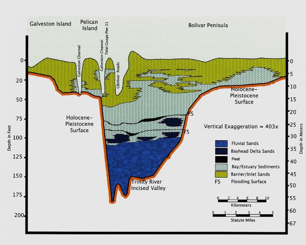
8 GEOLOGICAL DEPOSITION ON INCISED FLUVIAL VALLEYS
9 SEDIMENT-ACCUMULATION PROCESSES Anderson et al., 2016 Anderson, 2007


10 SEDIMENT IN BAYS Anderson et al., 2016


11 RECENT SEDIMENTS IN BAYS-INLETS Anderson et al., 2016
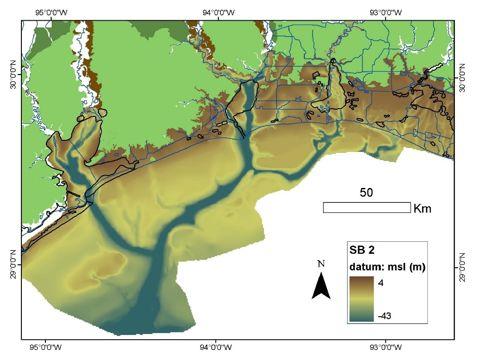
12 ESTIMATED SEDIMENT VOLUMES Geologic Unit: Offshore Trinity and Sabine Incised Valleys Location: From 10 to 50 km offshore Areal Extent: In average >150 km long, 10 km wide Water Depth: From 10 to 50 meters water depth Layer Thickness: >25 meters, variable depending of the paleo environment Sediment Characteristics: Episodic paleo river channel deposits (sand), bay head deltas (fines and sands), bays (fines), deltas (sand/mud) Potential Volumes/Quantities: 40,000,000,000 cubic meters Compatibility for Restoration of: Marshes and barrier islands Gaps: Specific studies need to be conducted for specific targets in terms of composition due to the presence of mixed sediments (sand and fines) and compaction levels may be high for some bay and fluvial deposits. This will also require analysis of the consistency of the overburden. Geologic Unit: Colorado River Delta Stage 3 Location: From 10 km 60 km from the beach (*) Areal Extent: See Figure 6-2 Water Depth: From -10 to -60 meters Layer Thickness: Variable depending of the paleo environment Sediment Characteristics: Episodic paleo river and delta deposits Potential Volumes/Quantities: 21 km3 (Anderson et al., 2016) Compatibility for Restoration of: Marshes and barrier islands Gaps: This is the closest paleo delta to the beach. Specific studies need to be conducted for specific targets in terms of composition (abundant sand was reported). Compaction levels may be high for some deltaic deposits. This will also require analysis of the consistency of the overburden. Some deposits may have high percent of fines. (* = High uncertainty-requires more data) Geologic Unit: Colorado River Delta Stage 2 to 1 Location: From 5 to 150 km from the beach on paleo incised channels (*) Areal Extent: In average >70 km long. See Figure 6-2 Water Depth: From -10 to -120 meters Layer Thickness: Estimated volume 21 km3 (Anderson et al., 2016) Sediment Characteristics: Episodic paleo river channel deposits Potential Volumes/Quantities: 77 km3 Compatibility for Restoration of: Marshes and barrier islands Gaps: Specific studies need to be conducted for specific targets in terms of composition due to the presence of mixed sediments (gravels, sand, and fines) and compaction levels may be high for some fine fluvial deposits. This will also require analysis of the consistency of the overburden (* = High Uncertainty-requires more data) Geologic Unit: Sabine Bank Facies A1 Location: From 30 to 50 km from the beach (*) Areal Extent: See Figure 6-1 Water Depth: >-10 meters (*) Layer Thickness: ~2 meters (Variable depending of the paleo environment) Sediment Characteristics: Former Barrier Island Potential Volumes/Quantities: 413,000,000 cubic meters (Dellapenna, 2009) Compatibility for Restoration of: Beaches and marshes Gaps: The deposits consist of sandy deposits. (* = High Uncertainty-requires more data)
 Areal Extent: See Figure 6-4 Water Depth: -2 to 15 meters (*) Layer Thickness: Up")

13 SEDIMENTS ON THE SHOREFACE Dellapenna, et al., 2013 Geologic Unit: Sand Bars on the Shoreface of Galveston Island Location: From 2 to 12 km from the beach (*) Areal Extent: See Figure 6-4 Water Depth: -2 to 15 meters (*) Layer Thickness: Up to 1 meter Sediment Characteristics: Sandy migrating bars Potential Volumes/Quantities: 1,800,000 to 3,000,000 cubic meters (Dellapenna, 2009) Compatibility for Restoration of: Beaches and marshes Gaps: The deposits consist of sand migrating to deeper areas and it may content fine deposits. These deposits may be available after storms in other portions of the Texas coast. (* = High Uncertainty-requires more data) Geologic Sedimentary Unit Potential Sediment Volume Sorted Bedform Shoals of the Shoreface ~184,257 cubic meters (on a single bedform)
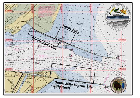
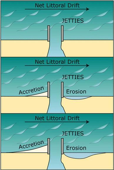
14 SEDIMENT IMPOUNDMENTS


15 USACE SEDIMENT TRANSPORT DATA/NRDA DATA
16 ANALYSIS OF DREDGE MATERIAL RELATED SOURCES USACE Galveston District dredging volumes for navigation channels (mainly maintenance dredging) USACE Navigation Data Center Database Location of past dredging events with associated volumes and potential locations of these sediments in nearby PAs Critical dredging hot spots along Texas Coast
 USACE Galveston")
 for Region 1 Trinity-Galveston Bay")
17 USACE Galveston District Cumulative Dredged Material by System ( ) USACE Galveston District Total Quantity of Sediment Dredged Annual by Year (CY) for Region 1 Trinity-Galveston Bay ( )
 Trinity-Galveston Bay Dredge")
18 Trinity-Galveston Bay Dredge Volumes (1991, 1994, , and ) Trinity-Galveston Bay Dredge Volumes
19 REPORT: Report to be cited as: Moya, J. Risko, A., Calvez, K., Gerkus, H., Weber, C., Buckley, K., and Nickerson, B Texas Sediment Sources-General Evaluation Study. A Texas General Land Office Contract No A Freese and Nichols, Inc. project under a sub-contract with Coast and Harbor Engineering, Inc. 247pp.
ΛTKINS. Applications of Regional Sediment Management Concepts in Texas Estuarine Restoration Projects. Riparian Workshop Fort Worth, October 17, 2012
 Juan C Moya, PhD., PG Coastal Planning and Restoration Applications of Regional Sediment Management Concepts in Texas Estuarine Restoration Projects Riparian Workshop Fort Worth, October 17, 2012 West
West Galveston Bay Regional Sediment Management Plan (An Eco-geomorphologic Approach)
") West Galveston Bay Regional Sediment Management Plan (An Eco-geomorphologic Approach) Juan Moya, Matthew Mahoney and Mike Smith Restore America s Estuaries Conference Tampa, FL, October 23, 2012 Atkins
West Galveston Bay Regional Sediment Management Plan (An Eco-geomorphologic Approach) Juan Moya, Matthew Mahoney and Mike Smith Restore America s Estuaries Conference Tampa, FL, October 23, 2012 Atkins
TEXAS COASTAL GEOLOGICAL DREDGING VS. GEOTECHNICAL DREDGING: CAN WE ANTICIPATE THE FUTURE?
 TEXAS COASTAL GEOLOGICAL DREDGING VS. GEOTECHNICAL DREDGING: CAN WE ANTICIPATE THE FUTURE? J.C. Moya 1, M. Mahoney 2, T. Dellapenna 3, C. Weber 1, T. Dixon 1 ABSTRACT How much do we really know about our
Material Workshop. Galveston District 2012 Beneficial Use of Dredged. Material Workshop. Custodians of the Coast
 Galveston District 2012 Beneficial Use of Dredged Material Workshop Galveston District 2012 Beneficial Use of Dredged Material Workshop US Army Corps of Engineers BUILDING STRONG Welcome Opening Remarks
Regional-scale understanding of the geologic character and sand resources of the Atlantic inner continental shelf, Maine to Virginia
 Regional-scale understanding of the geologic character and sand resources of the Atlantic inner continental shelf, Maine to Virginia Workshop on Dredging, Beach Nourishment and Bird Conservation Atlantic
The Impact of Changing Winds on Estuarine Evolution, Copano Bay, TX
 The Impact of Changing Winds on Estuarine Evolution, Copano Bay, TX Purpose: The fulfillment of partial requirements for the Degree of Master of Science in Geology Oklahoma State University, Stillwater
GALVESTON BAY RSM Moving toward an Integrated, Cooperative, and Holistic Approach to Estuarine Sediments
 GALVESTON BAY RSM Moving toward an Integrated, Cooperative, and Holistic Approach to Estuarine Sediments RAE Conference 2010 Larry A. Wise Moffatt & Nichol RSM is a system-based approach for collaboratively
MISSISSIPPI RIVER DELTA OVERVIEW
 MISSISSIPPI RIVER DELTA OVERVIEW Science and Engineering Special Team Conference Louisiana State University October 9, 2012 Introduction Basics of the Mississippi Delta Natural and Human-Induced Land Loss
Michael Walsworth, Ryan Sullivan, Simi Odueyungbo, William Budd
 Michael Walsworth, Ryan Sullivan, Simi Odueyungbo, William Budd Estuarine Environment At first (Pritchard, 1967), an estuary was defined by the salinity of the water. Then by Clifton (1982) as an inlet
EARTH SURFACE PROCESSES AND SEDIMENTATION!
 Sed and Strat EARTH SURFACE PROCESSES AND SEDIMENTATION! 2/27 Lecture 7- Exposure: Weathering and the Sediment Factory 3/04 Lecture 8 - Rivers and Landscapes 3/06 Lecture 9 - Waves (not Tides) 3/11 Lecture
Coastal Inlets Research Program US Army Corps of Engineers Engineering Research and Development Center
 Coastal Inlets Research Program US Army Corps of Engineers Engineering Research and Development Center Site of Moriches Inlet Nov. 1951 Julie Dean Rosati and Nicholas C. Kraus, CIRP Program Manager Shinnecock
Regional Sediment Management
 Regional Sediment Management Linda S. Lillycrop Program Manager Coastal Engineer US Army Engineer Research and Development Center Coastal and Hydraulics Laboratory Q AVG Coastal Resilience: The Environmental,
Heather Schlosser Army Corps of Engineers Coastal Studies Group August 28, 2008
 Got sand? Regional Sediment Management in Orange County Heather Schlosser Army Corps of Engineers Coastal Studies Group August 28, 2008 Regional Sediment Management Regional sediment management recognizes
Coastal Sediment Properties and Longshore Sediment Transport
 Coastal Sediment Properties and Longshore Sediment Transport Julie Rosati Julie.D.Rosati@erdc.usace.army.mil 601-634-3005 Coastal Planning Course Lesson #8 Tuesday 8:00-9:00 am CEM III-1, III-2 1. Coastal
ENGINEERING APPROACHES TO SHORELINE PLACEMENT FROM COAST TO COAST
 ENGINEERING APPROACHES TO SHORELINE PLACEMENT FROM COAST TO COAST 237 237 237 217 217 217 200 200 200 0 0 0 163 163 163 131 132 122 80 119 27 252 174.59 83 36 118 110 135 120 112 92 56 62 102 130 Comparing
Anderson-Ketron PSDDA Disposal Site Fate and Transport Modeling
 Pierce County Washington Anderson-Ketron PSDDA Disposal Site Fate and Transport Modeling Design Memorandum September 2014 Table of Contents 1 Introduction... 3 1.1 Purpose and Scope... 3 1.2 Project Description:
Geological record of severe storm impacts along the Texas Coast. Davin Wallace 1, John Anderson 1, Winnie Yu 1 and Antonio Rodriguez 2
 Geological record of severe storm impacts along the Texas Coast Davin Wallace 1, John Anderson 1, Winnie Yu 1 and Antonio Rodriguez 2 1 2 Motivation Understand natural evolution of stressed barrier island
GenCade. Combining and Extending the GENESIS and Cascade Models for Planning and Design in a Regional Sediment Management Framework
 GenCade Combining and Extending the GENESIS and Cascade Models for Planning and Design in a Regional Sediment Management Framework G Presented by Nicholas C. Kraus For the GenCade Development Team Ken
The Sediment Budget Calculator: A Webtool to Develop a Family of Viable Inlet and Adjacent Beach Sediment Budget Solutions
 The Sediment Budget Calculator: A Webtool to Develop a Family of Viable Inlet and Adjacent Beach Sediment Budget Solutions by Julie Dean Rosati, Charles A. Sumner, and Derek A. Wilson PURPOSE: This Coastal
THE QUATERNARY GEOLOGY OF NEWARK BAY AND KILL VAN KULL CHANNEL, NEW YORK AND NEW JERSEY. and
 THE QUATERNARY GEOLOGY OF NEWARK BAY AND KILL VAN KULL CHANNEL, NEW YORK AND NEW JERSEY Stephanie Beda, W. Bruce Ward, William Murphy, Robert Fleming, Gary Fleming, Beckett Boyd Earthworks LLC 27 Glen
Primer on Coastal Erosion And Habitat Creation
 2 nd Regional Conference Dredging, Beach Nourishment & Bird Conservation Primer on Coastal Erosion And Habitat Creation Timothy Kana Ph.D Source: Newsday 1962 Photo by Kelsey Aerials 1978 Source: U Mass
MODELING OF EROSION CONTROL ALTERNATIVES AT STUMP PASS, CHARLOTTE COUNTY
 2014 NATIONAL CONFERENCE ON BEACH PRESERVATION TECHNOLOGY FEBRUARY 13, 2014 MODELING OF EROSION CONTROL ALTERNATIVES AT STUMP PASS, CHARLOTTE COUNTY 1 VADIM ALYMOV, PH.D. 2 CHUCK MOPPS 3 MICHAEL POFF,
Regional Sediment Management: The Long Island Coastal Planning Project
 Regional Sediment Management: The Long Island Coastal Planning Project Lynn M. Bocamazo Senior Coastal Engineer USACE-New York District 22 September 2009 US Army Corps of Engineers Outline Project Location
ANALYSIS OF SEISMIC PROFILES AND SIDE-SCAN SONAR RECORDS FROM LOWER NEW YORK HARBOR, A PROGRESS REPORT. Roger D. Flood Vicki Lynn Ferrini
 45 ANALYSIS OF SISMIC PROFILS AND SID-SCAN SONAR RCORDS FROM LOWR NW YORK HARBOR, A PROGRSS RPORT Roger D. Flood Vicki Lynn Ferrini Marine Sciences Research Center State University of New York, Stony Brook,
Planning for the Future of Humboldt Bay: Sea Level Rise, Sediment Management, Sand Spits and Salt Marshes. Joel Gerwein
 Planning for the Future of Humboldt Bay: Sea Level Rise, Sediment Management, Sand Spits and Salt Marshes Joel Gerwein Introduction to Humboldt Bay Setting Economy, community, and environment Sediment
Final Report on Development of Deep Aquifer Database and Preliminary Deep Aquifer Map
 4 CHAPTER Final Report on Development of Deep Aquifer Database and Preliminary Deep Aquifer Map 31 Chronostragraphic Mapping 4.1 Introduction The analysis of geological logs was conducted during the project
The Coast: Beaches and Shoreline Processes
 1 2 3 4 5 6 7 8 9 The Coast: es and Shoreline Processes Trujillo & Thurman, Chapter 10 Oceanography 101 Chapter Objectives Recognize the various landforms characteristic of beaches and coastal regions.
The Coast: Beaches and Shoreline Processes Trujillo & Thurman, Chapter 10
 The Coast: es and Shoreline Processes Trujillo & Thurman, Chapter 10 Oceanography 101 Chapter Objectives Recognize the various landforms characteristic of beaches and coastal regions. Identify seasonal
Sediment Data for the Texas Coast
 Sediment Data for the Texas Coast Ray Newby, P.G. Coastal Geologist Coastal Resources Program Texas General Land Office George P. Bush, Land Commissioner Texas General Land Office (GLO) and the Texas Coast:
Sediment Traps. CAG Meeting May 21, 2012
 Sediment Traps CAG Meeting May 21, 2012 Agenda Background Fundamentals of Sediment Transport Sediment Trap Existing Information Next Steps 2 The Site Saginaw River 22 mile river beginning at confluence
Pinellas, Manatee, and Sarasota Counties, Florida; Regional Sediment Budget
 Pinellas, Manatee, and Sarasota Counties, Florida; Regional Sediment Budget by Kelly R. Legault and Ashley E. Frey PURPOSE: This U.S. Army Corps of Engineers (USACE) Regional Sediment Management Technical
ENGINEERING WITH NATURE: NEARSHORE BERM PLACEMENTS AT FORT MYERS BEACH AND PERDIDO KEY, FLORIDA, USA
 1 ENGINEERING WITH NATURE: NEARSHORE BERM PLACEMENTS AT FORT MYERS BEACH AND PERDIDO KEY, FLORIDA, USA KATHERINE E. BRUTSCHÉ 1, PING WANG 2, JULIE D. ROSATI 1, CHERYL E. POLLOCK 1 1. U.S. Army Engineer
Kristy Milliken, Rice University
 2005 GCSSEPM Foundation Ed Picou Fellowship Grant for Graduate Studies in the Earth Sciences Recipient Kristy Milliken, Rice University Controls on the Transgressive facies of coastal plain incised valley
The U.S. Army Corps of Engineers Philadelphia District
 The U.S. Army Corps of Engineers Philadelphia District The Atlantic Coast of New Jersey Regional Sediment Budget 1986-2003 Cape May Point to Manasquan Inlet Final Report March 2006 The Atlantic Coast of
Lab 12 Coastal Geology
 Lab 12 Coastal Geology I. Fluvial Systems Hydrologic Cycle Runoff that flows into rivers = precipitation (rain and snowmelt) [infiltration (loss to groundwater) + evaporation (loss to atmosphere) + transpiration
Forecast of Nearshore Wave Parameters Using MIKE-21 Spectral Wave Model
 Forecast of Nearshore Wave Parameters Using MIKE-21 Spectral Wave Model Felix Jose 1 and Gregory W. Stone 2 1 Coastal Studies Institute, Louisiana State University, Baton Rouge, LA 70803 2 Coastal Studies
Geology Setting Management Options Management Structure
 Geology Setting Management Options Management Structure WFF = Wallops Flight Facility LST = Longshore sediment transport SLR = Sea level rise September 29, 2015 Accomack County/Accomack Northampton County
The Marine Environment
 The Marine Environment SECTION 16.1 Shoreline Features In your textbook, read about erosional landforms, beaches, estuaries, longshore currents, and rip currents. For each statement below, write true or
Monitoring Shoreline Change along Assateague Barrier Island: The First Trend Report
 Journal of Coastal Research SI 64 8-84 ICS211 (Proceedings) Poland ISSN 749-28 Monitoring Shoreline Change along Assateague Barrier Island: The First Trend Report N. P. Psuty and T. M. Silveira Marine
Geol 117 Lecture 18 Beaches & Coastlines. I. Types of Coastlines A. Definition:
 I. Types of Coastlines A. Definition: 1. Shore = narrow zone where ocean meets land (e.g. beach) 2. Coast is a broad area where both ocean and land processes act a. Includes onshore marshes, dunes, sea
Weathering of Rocks. Weathering - Breakdown of rocks into pieces (sediment) 2 main types of weathering to rocks
 2 main types of weathering to rocks") Weathering of Rocks Weathering - Breakdown of rocks into pieces (sediment) 2 main types of weathering to rocks Mechanical weathering requires physical forces to break rocks into smaller pieces. Chemical
Weathering of Rocks Weathering - Breakdown of rocks into pieces (sediment) 2 main types of weathering to rocks Mechanical weathering requires physical forces to break rocks into smaller pieces. Chemical
The Marine Environment
 The Marine Environment SECTION 16.1 Shoreline Features In your textbook, read about erosional landforms, beaches, estuaries, longshore currents, and rip currents. For each statement below, write or. 1.
MEMORANDUM FOR SWG
 MEMORANDUM FOR SWG-2007-1623 Subject: Jurisdictional Determination (JD) for SWG-2007-1623 on Interdunal Wetlands Adjacent to Traditional Navigable Waters (TNWs) Summary The U.S. Environmental Protection
Appendix D. Sediment Texture and Other Soil Data
 5 6 7 8 Appendix D. Sediment Texture and Other Soil Data This appendix describes the sediment texture of the aquifer system in the Restoration Area. The contents of this appendix describe the: Importance
Supplemental Slides. Shore: Junction of Land & Water. Junction of Land & Water. Sea Level Variations. Shore vs. Coast. Sea Level Variations
 Shore: Junction of Land & Water Supplemental Slides Sediments come off land Most get dumped at the beach Sediment interacts with ocean waves and currents Junction of Land & Water Features: Breaking waves,
Shore: Junction of Land & Water. Sediments come off land Most get dumped at the beach Sediment interacts with ocean waves and currents
 Shore: Junction of Land & Water Supplemental Slides Sediments come off land Most get dumped at the beach Sediment interacts with ocean waves and currents Junction of Land & Water Features: Breaking waves,
Redwood City Harbor, California, Navigation Improvement Feasibility Study. Appendix D. Geotechnical Engineering. DRAFT April 2015
 1 Redwood City Harbor, California, Navigation Improvement Feasibility Study Appendix D Geotechnical Engineering DRAFT April 2015 2 Contents 1 Purposes of Report... 3 2 Background... 3 3 References and
Lab 7: Sedimentary Structures
 Name: Lab 7: Sedimentary Structures Sedimentary rocks account for a negligibly small fraction of Earth s mass, yet they are commonly encountered because the processes that form them are ubiquitous in the
Holocene Carbonate-Siliciclastic Shoreline and Ravinement Stratigraphy of the Belize Lagoon: a Mixed-System Model
 Holocene CarbonateSiliciclastic Shoreline and Ravinement Stratigraphy of the Belize Lagoon: a MixedSystem Model DONALD F. MCNEILL AND CLINTON A. COWAN Key findings o Mixedsystem facies heterogeneity during
The Systems Approach. Alun Williams, ABPmer
 The Systems Approach Alun Williams, ABPmer Overview What is A Systems Approach? Behavioural / Qualitative Modelling? System Definition / Mapping (Behavioural Statements Objective) What is a Systems Approach?
A National Outer Continental Shelf Sand / Sediment Inventory
 A National Outer Continental Shelf Sand / Sediment Inventory Sand Resource Areas Lease Areas Lora Turner December 15, 2016 Restoring and Protecting Our Nation s Coasts through Stewardship of OCS Resources
DESIGN ENGINEERING ANALYSIS FOR TERMINAL GROIN LENGTH
 APPENDIX F DESIGN ENGINEERING ANALYSIS FOR TERMINAL GROIN LENGTH (Prepared by Olsen Associates, Inc.) DRAFT Environmental Impact Statement Village of Bald Head Island Shoreline Protection Project Brunswick
Donald K. Stauble and Bill Birkemeier Coastal and Hydraulics Laboratory US Army Corps of Engineers
 Donald K. Stauble and Bill Birkemeier Coastal and Hydraulics Laboratory US Army Corps of Engineers Define the Problem Navigation Shore Protection Environmental Political So what is the problem? Management
Mark H. Horwitz Ping Wang PhD Coastal Research Laboratory, School of Geosciences University of South Florida
 Mark H. Horwitz Ping Wang PhD Coastal Research Laboratory, School of Geosciences University of South Florida American Shore & Beach Preservation Association 2015 National Coastal Conference, New Orleans,
DATA REPOSITORY MATERIAL: PALEOCHANNEL GROUP MAPPING DESCRIPTIONS
 Data Repository item 2695 DATA REPOSITORY MATERIAL: PALEOCHANNEL GROUP MAPPING DESCRIPTIONS Groups 1 (North Myrtle Beach) and 2 (Atlantic Beach) Channel Groups 1 (North Myrtle Beach) and 2 (Atlantic Beach)
COASTAL SEDIMENT BUDGET FOR JUPITER INLET, FLORIDA
 COASTAL SEDIMENT BUDGET FOR JUPITER INLET, FLORIDA By KRISTEN MARIE ODRONIEC A THESIS PRESENTED TO THE GRADUATE SCHOOL OF THE UNIVERSITY OF FLORIDA IN PARTIAL FULFILLMENT OF THE REQUIREMENTS FOR THE DEGREE
Earth Wind & Fire. Game Changing Restoration Options in the Texas Chenier Plain
 Earth Wind & Fire Game Changing Restoration Options in the Texas Chenier Plain EARTH: The Chenier Plain is a 5 million acre coastal region in Southwest Louisiana and Southeast Texas providing landscape
Sediment Management in the Coastal Bays
 Sediment Management in the Coastal Bays Introduction Need for ecosystem view of sediment management in Coastal Bays Island loss and restoration Navigation needs Habitat Trade offs Living Shoreline Requirements
Freshwater-Tidal Gradients: Eco-geomorphology Linkages to Watershed-Estuarine Dynamics
 Freshwater-Tidal Gradients: Eco-geomorphology Linkages to Watershed-Estuarine Dynamics Kathy Boomer (The Nature Conservancy) Scott Ensign (Stroud Research) Greg Noe (USGS) Concluding Speculations: It s
THE IMPORTANCE OF SCIENCE IN COASTAL RESTORATION IN LOUISIANA
 THE IMPORTANCE OF SCIENCE IN COASTAL RESTORATION IN LOUISIANA Barb Kleiss USACE, Mississippi Valley Division August 3, 2011 LCA S&T Office Authorized under WRDA 2007 Designed to address technical issues
DEPARTMENT OF THE ARMY WATERWAYS EXPERIMENT STATION. CORPS OF ENGINEERS P. 0. BOX 631 VICKSBURG. MISSISSIPPI 39180
 DEPARTMENT OF THE ARMY WATERWAYS EXPERIMENT STATION. CORPS OF ENGINEERS P. 0. BOX 631 VICKSBURG. MISSISSIPPI 39180 IN REPLY REF6R TO: WESYV 31 July 1978 SUBJECT: Transmittal of Technical Report D-78-34
KEYWORDS: erosion shoreline change nourishment community issues
 UNC Coastal Studies Institute 1 TITLE: Sand, Soil, Sediment Selection for Beach Nourishment KEYWORDS: erosion shoreline change nourishment community issues ABSTRACT: North Carolina s barrier islands are
A SEDIMENT BUDGET ANALYSIS AND MANAGEMENT STRATEGY FOR FORT PIERCE INLET, FL
 A SEDIMENT BUDGET ANALYSIS AND MANAGEMENT STRATEGY FOR FORT PIERCE INLET, FL By Elba Rodriguez and Robert G. Dean Department of Civil and Coastal Engineering University of Florida Gainesville, FL 32611,
Landscape Development
 Landscape Development Slopes Dominate Natural Landscapes Created by the interplay of tectonic and igneous activity and gradation Deformation and uplift Volcanic activity Agents of gradation Mass wasting
The Mississippi River: Its Role in Restoration Efforts and Potential Effects of Climate Change
 The Mississippi River: Its Role in Restoration Efforts and Potential Effects of Climate Change Clinton S. Willson, P.E., Ph.D. Department of Civil & Environmental Engineering Louisiana State University
II Why study coastal landforms?
 COASTAL LANDFORMS (32) I Main topics A Why study coastal landforms? B Sediment budget and system response C Coastal landforms 3/26/15 GG454 1 II Why study coastal landforms? A Dynamic systems B Reflect
Solutions to Flooding on Pescadero Creek Road
 Hydrology Hydraulics Geomorphology Design Field Services Photo courtesy Half Moon Bay Review Solutions to Flooding on Pescadero Creek Road Prepared for: San Mateo County Resource Conservation District
Red River Levee Panel
 Red River Levee Panel Mississippi River Commission Monday, August 9, 2017 Red River Levees in LA & AR NONE along TX & OK Boarder Red River Levee Issues Caddo Levee Cherokee Park Authorization Bossier Levee
Geomorphology Geology 450/750 Spring Fluvial Processes Project Analysis of Redwood Creek Field Data Due Wednesday, May 26
 Geomorphology Geology 450/750 Spring 2004 Fluvial Processes Project Analysis of Redwood Creek Field Data Due Wednesday, May 26 This exercise is intended to give you experience using field data you collected
L7/ Historical Perspec=ve, Deltas
 Colin Woodroffe (2002) Coasts: Form, Process and Evolu=on, Outline of Chapter 7: L7/1 L7/2 7.1. Historical Perspec=ve, 7.1.1. Deltas Herodotus (450, B.C.) delta = Shape of Nile River Delta = Δ Gilbert
Sediment Transport Analysis for Stream Restoration Design: The Good, the Bad, and the Ugly.
 Sediment Transport Analysis for Stream Restoration Design: The Good, the Bad, and the Ugly. Brett Jordan Phd, PE HydroGeo Designs LLC. Land and Water Services Inc. THE GOOD THE BAD THE UGLY THE GOOD THE
Assessment of the Hood River Delta Hood River, Oregon
 Assessment of the Hood River Delta Hood River, Oregon Pacific Northwest Waterways Association Annual Meeting October 13, 2010 Michael McElwee, Executive Director Port of Hood River Overview U.S. Army Corps
 Red River Flooding June 2015 Caddo and Bossier Parishes Presented by: Flood Technical Committee Where the Rain Falls Matters I-30 versus I-20 I-20 Backwater and Tributary Floods (Localized) 2016 Flood
Remaining Capacity in Great Lakes Reservoirs
 US Army Corps of Engineers Detroit District Remaining Capacity in Great Lakes Reservoirs Storage Capacity Behind Great Lakes Dams Field Data and Modeling Motivation for project Project overview Data and
Integrated geological approach to the study of coastal subsidence in Emilia-Romagna. Luisa PERINI Calabrese Lorenzo, Luciani Paolo, Severi Paolo,
 Integrated geological approach to the study of coastal subsidence in Emilia-Romagna Luisa PERINI Calabrese Lorenzo, Luciani Paolo, Severi Paolo, Subsidence hazard of Emilia-Romagna coastal plain Caputo
EAGLES NEST AND PIASA ISLANDS
 EAGLES NEST AND PIASA ISLANDS HABITAT REHABILITATION AND ENHANCEMENT PROJECT MADISON AND JERSEY COUNTIES, ILLINOIS ENVIRONMENTAL MANAGEMENT PROGRAM ST. LOUIS DISTRICT FACT SHEET I. LOCATION The proposed
GEOL 440 Sedimentology and stratigraphy: processes, environments and deposits Lectures 16 & 17: Deltaic Facies
 GEOL 440 Sedimentology and stratigraphy: processes, environments and deposits Lectures 16 & 17: Deltaic Facies What controls morphology and facies of the Nile Delta? Basic processes Classification Facies
BUDGET. Investigation of natural sand transport on the Belgian continental shelf
 BUDGET Investigation of natural sand transport on the Belgian continental shelf Funded by Federal Office for Scientific, Technical and Cultural Affairs Program: Sustainable Management of the North Sea
Influence of the Major Drainages to the Mississippi River and Implications for System Level Management
 Influence of the Major Drainages to the Mississippi River and Implications for System Level Management Brian M. Vosburg Geologist Louisiana Coastal Protection and Restoration Authority brian.vosburg@la.gov
Winfried Siefert ; Volker Barthel**' and
 CHAPTER 176 THE GERMAN "MORAN" PROJECT by Winfried Siefert ; Volker Barthel**' and Abstract The project "MORAN" (Morphological Analyses of the North- Sea-Coast) is an extensive program in order to try
June 2018 Sediments and Dredging at GBR Ports
 June 2018 Sediments and Dredging at GBR Ports Reef 2050 Long Term Sustainability Plan The Great Barrier Reef is over 2000 km long and covers an area of approximately 350,000 square kilometres. It is a
Regional Sediment Management at East Rockaway Inlet, NY, Utilizing the USACE Coastal Modeling System
 Regional Sediment Management at East Rockaway Inlet, NY, Utilizing the USACE Coastal Modeling System by US Army Engineer District, New York PURPOSE: This Coastal and Hydraulics Engineering Technical Note
ON THE EVOLUTION OF A HOLOCENE BARRIER COAST
 ON THE EVOLUTION OF A HOLOCENE BARRIER COAST Response to sea-level change and sediment supply DANCORE Seminar 2014 COADAPT - Danish Coasts and Climate Adaptation Flooding Risk and Coastal Protection Mikkel
Quantifying i the GLRI Metric for Annual Sediment Deposition in Great Lakes Harbors:
 USACE 516(e) Annual Meeting Ann Arbor, MI (May 15, 2013) Quantifying i the GLRI Metric for Annual Sediment Deposition in Great Lakes Harbors: A Pilot Evaluation for Toledo Harbor Todd Redder Joe DePinto
Coastal and Hydraulics Laboratory
 ERDC/CHL TR-09-6 Houston-Galveston Navigation Channels, Texas Project Navigation Channel Sedimentation Study, Phase 2 Plan Simulations Jennifer N. Tate and Cassandra G. Ross August 2009 Coastal and Hydraulics
Map 9: Ayrshire Coast: Stevenston Pier to Barassie Map Content Descriptions
 Map 9: Ayrshire Coast: Stevenston Pier to Barassie Map Content Descriptions 1. Built Heritage and Archaeology A total of thirteen sites were recorded in the area covered by Map 9. Of these five were previously
Mapping of Future Coastal Hazards. for Southern California. January 7th, David Revell, Ph.D. E.
 Mapping of Future Coastal Hazards for Southern California January 7th, 2014 David Revell, Ph.D. drevell@esassoc.com E. Vandebroek, 2012 Outline Coastal erosion hazard zones Flood hazard zones: Coastal
Waterbury Dam Disturbance Mike Fitzgerald Devin Rowland
 Waterbury Dam Disturbance Mike Fitzgerald Devin Rowland Abstract The Waterbury Dam was completed in October 1938 as a method of flood control in the Winooski Valley. The construction began in April1935
Appendix D Geotechnical
 USACE JACKSONVIE DISTRICT Appendix D Geotechnical LEE COUNTY GASPARIA SHORE PROTECTION PROJECT 934 REPORT June 216 TABLE OF CONTENTS 1 Background... 1 1.1 Regional Geology... 1 1.2 Local Geology... 2 2
Appendix I. Dredged Volume Estimates. Draft Contractor Document: Subject to Continuing Agency Review
 Appendix I Dredged Volume Estimates Draft Contractor Document: Subject to Continuing Agency Review Interoffice Correspondence Date: April 6, 2007 To: L. Bossi (WHI) Copy: S. Thompson (WHI), B. Fidler (NNJ)
Griswold Creek August 22, 2013
 Creek August 22, 2013 1 Lake Erie Protection Fund Creek Study ver Evaluate the overall condition of Creek Determine stable channel dimensions & appropriate restoration techniques Starting Stat gpoint for
THC-T-2013 Conference & Exhibition
 Modeling of Shutter Coastal Protection against Storm Surge for Galveston Bay C. Vipulanandan, Ph.D., P.E., Y. Jeannot Ahossin Guezo and and B. Basirat Texas Hurricane Center for Innovative Technology (THC-IT)
Introduction to sequence stratigraphy and its application to reservoir geology
 Introduction to sequence stratigraphy and its application to reservoir geology Massimo Zecchin Istituto Nazionale di Oceanografia e di Geofisica Sperimentale - OGS Historical development Definitions Systems
Diagnostic Geomorphic Methods for Understanding Future Behavior of Lake Superior Streams What Have We Learned in Two Decades?
 Diagnostic Geomorphic Methods for Understanding Future Behavior of Lake Superior Streams What Have We Learned in Two Decades? Faith Fitzpatrick USGS WI Water Science Center, Middleton, WI fafitzpa@usgs.gov
Whiskey Island Marsh Creation Rolling with the Punches
 Whiskey Island Marsh Creation Rolling with the Punches Santiago Alfageme, M&N Jerry Carroll, LADNR Brad Miller, LADNR Project Location Historic Island Retreat Previous Restoration Project Whiskey Island
APPENDIX B. BORROW SOURCE INVESTIGATIONS East Rockaway Inlet to Rockaway Inlet, NY, Reformulation Study
 APPENDIX B BORROW SOURCE INVESTIGATIONS East Rockaway Inlet to Rockaway Inlet, NY, Reformulation Study 1. Objective. The East Rockaway Inlet to Rockaway Inlet and Jamaica Bay, NY, Reformulation Study is
Subcommittee on Sedimentation Draft Sediment Analysis Guidelines for Dam Removal
 Subcommittee on Sedimentation Draft Sediment Analysis Guidelines for Dam Removal August 4, 2011 Jennifer Bountry, M.S., P.E. Tim Randle, M.S., P.E., D.WRE. Blair Greimann, Ph.D., P.E. Sedimentation and
1 Shoreline Landforms 2. 2 Emergent v. Submergent 2. 3 Wavecutting 3. 4 Planview 4. 5 Marine Terraces 5. 6 California 7. 7 Tombolos, Sea Stacks 8
 Shorelines November 9, 2008 Contents 1 Shoreline Landforms 2 2 Emergent v. Submergent 2 3 Wavecutting 3 4 Planview 4 5 Marine Terraces 5 6 California 7 7 Tombolos, Sea Stacks 8 8 Active Processes 9 9 Emergence
Which map shows the stream drainage pattern that most likely formed on the surface of this volcano? A) B)
 B)") 1. When snow cover on the land melts, the water will most likely become surface runoff if the land surface is A) frozen B) porous C) grass covered D) unconsolidated gravel Base your answers to questions
1. When snow cover on the land melts, the water will most likely become surface runoff if the land surface is A) frozen B) porous C) grass covered D) unconsolidated gravel Base your answers to questions
SEGMENTED BREAKWATERS AND THEIR USE IN COASTAL LOUISIANA
 SEGMENTED BREAKWATERS AND THEIR USE IN COASTAL LOUISIANA Prepared by: Louisiana Coastal Protection and Restoration Authority Engineering Division March 2016 The geology of Louisiana s coastal zone is intimately