MISSISSIPPI RIVER DELTA OVERVIEW
|
|
|
- Edmund Todd
- 5 years ago
- Views:
Transcription

1 MISSISSIPPI RIVER DELTA OVERVIEW Science and Engineering Special Team Conference Louisiana State University October 9, 2012
2 Introduction Basics of the Mississippi Delta Natural and Human-Induced Land Loss Impact of Sea Level Change Projections of Sea Level-Subsidence
")

3 Delta Type by Dominant Process (modified from Galloway, 1975) Delta Characteristics = Fluvial vs. Receiving Basin Processes

4 Major Deltas of the World

5 Deltas are Part of Much Larger System Modulated by Sea Level
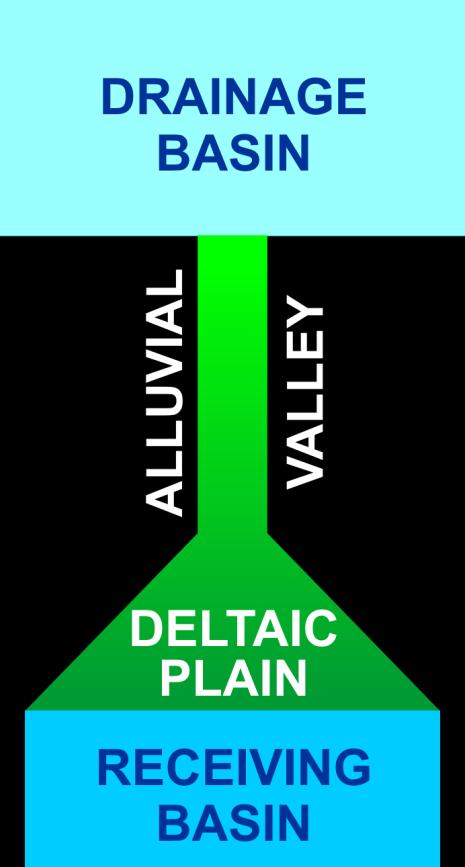
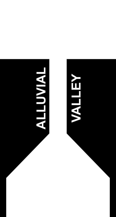
6 Components of a River-Delta System

7 Six Major Drainage Basins of the Mississippi River Watershed


8 Mississippi River Delta Holocene History of Delta Growth 6 major coupled channel belts and delta complexes Like most major deltas, growth occurred after ca yrs BP
9 Temporal Scale of Pulsing Events in Deltaic Systems Event Timescale Impact River switching 1,000-1,500 yrs Deltaic lobe formation Net advance of deltaic landmass, Barrier Island Formation Major river floods yrs Channel switching initiation Crevasse splay formation Major deposition Major storms 5-20 yrs Major deposition Enhanced production Average river floods Annual Freshening (lower salinity) Nutrient input Normal storm events (Fronts) Weekly Enhanced 1º and 2º production Enhanced production Organism transport Net material transport Tides Daily Drainage/marsh production Low net transport Modified from John Day
10

11 Factors Causing Land Loss Mississippi Delta Natural: Tectonic Subsidence Delta Switching (subsidence under load) Consolidation Sea Level Rise Hurricanes Faulting Biological Man-Induced Dams, Levees, Impoundments Fluid Withdrawal Canal Dredging Salt Water Intrusion
")
12 Dynamic Shifting of the Modern Mississippi River (Fisk, 1944)

13 Environmental Transformation Historic-period levees decoupled delta plain from fluvial sediment source Global sea level rise started accelerating No doubt, the great benefit to the present and two or three following generations accruing from a complete system of absolutely protective levees, excluding the flood waters entirely from the great areas of the lower delta country, far outweighs the disadvantages to future generations from the subsidence of the Gulf delta lands below the level of the sea and their gradual abandonment due to this cause (Corthelll 1897)

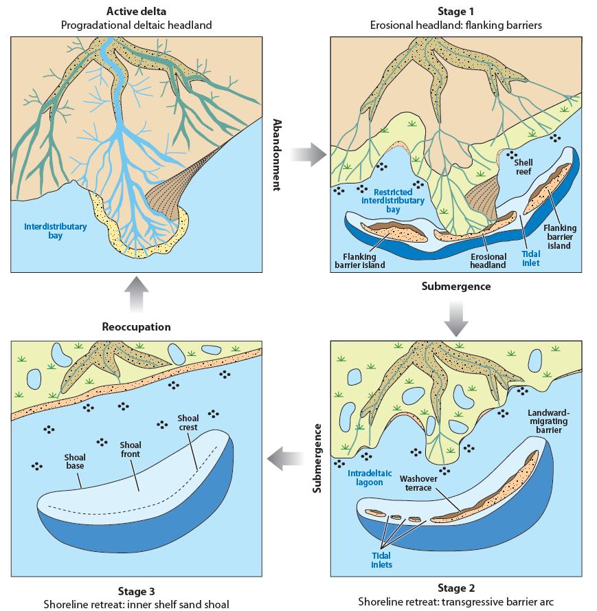
14 Mississippi Delta Land Loss and Gain Barras et al. (2003)
15 Context for Modern Delta by Summarizing Geological History of Lower Mississippi Valley and Delta Region

16 Cretaceous to 65.5 MYA Mississippi Embayment Formed, began to focus sediment input to GOM during Late Cretaceous Mississippi Embayment formed, focused sediment in late Cretaceous Modern land-surface dynamics Conditioned by longer-term processes indigenous to the Mississippi depocenter CO Plateau Geosystems

17 Paleogene 65.6 to 23 MYA Series of Smaller-Scale River Systems entered GOM in what is now south Louisiana CO Plateau Geosystems Shelf Margin at New Orleans MYA
18 Miocence 23 to 5.3 MYA Mississippi Embayment Emerged as Primary Focus for Sediment Input CO Plateau Geosystems ~200 km of shelf margin progradation Foundation for Modern Delta Region

19 Plio-Pleistocene < 5 MYA Sediment Loading CO Plateau Geosystems Depocenter extends ~400 km along Mississippi and Louisiana Coasts Foundations for the Modern Delta reflect evolution of Depocenter
20 Delta Region Foundation Fluvial to shallow marine sediments >500 m thickness Sediment thickness > 4,000 m Delta region is inherently unstable, with subsidence processes that are driven by depocenter loading
21 Modern alluvial-deltaic landscape directly reflects the response of the Mississippi system to climate and sea-level changes from the last interglacial period to the present.

22 Sea Level History

23 Marine Isotope State 5 ca KYA Lower Mississippi and Delta Looked Much Like Today Last Interglacial MI5 Delta Plain (or Prairie Terrace) extended further west Meandering channels characterized alluvial valley

24 Large Scale Changes in Channel Morphology and Climate and Sea-Level Changes Lower MS channel was braided and routed meltwater, incised through Prairie Terrace Shoreline located at shelf margin and up to 120 m lower in elevation


25 Vicksburg Baton Rouge New Madrid Memphis New Orleans Mississippi incised valley The Lower Mississippi River and Delta Glacial-period braided streams within incised valley Holocene valley filling and delta construction Valley fill reflects interactions between climate and sea-level change

26 Delta Plain Landscape Glacial Period Incised Valley and Complex Deltaic Deposits Modified from Autin et al 1991


27 Block Diagram of Mississippi Alluvial Valley at the Latitude of Natchez, MS
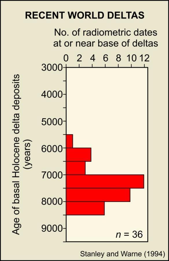
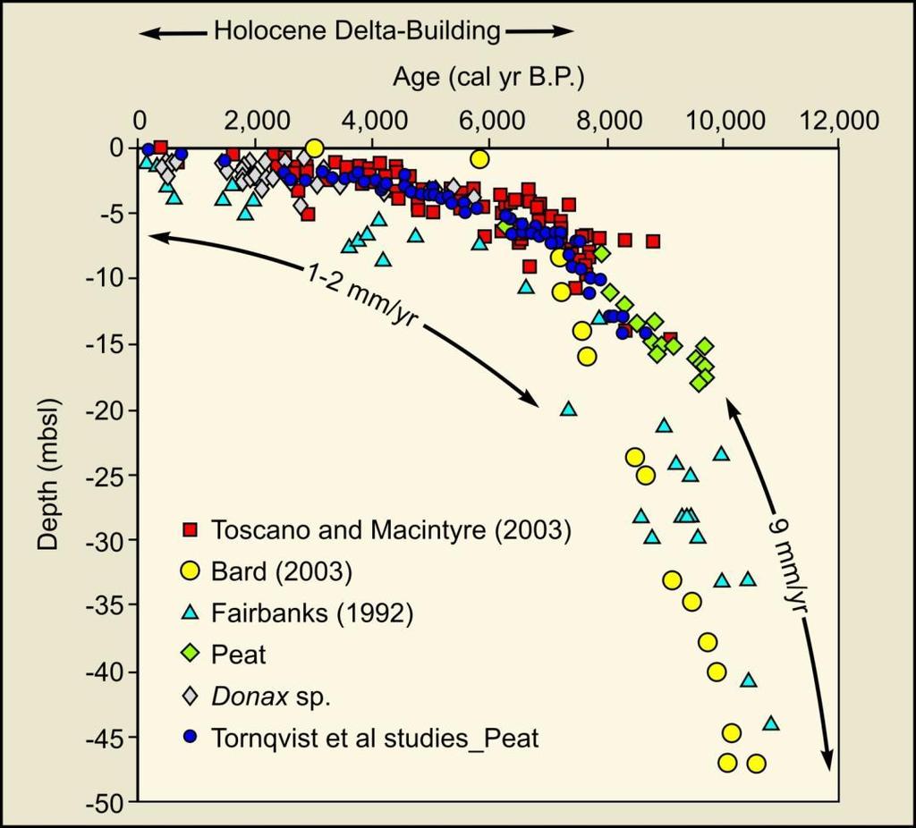
28 Initiation of Holocene World Deltas


29 Most Holocene Delta Plains Similarly Constructed, after SLR Decelerated Mississippi 28,568 km 2 Gulf of Mexico Yangtze-Kiang 66,669 km 2 Ganges-Brahmaputra 105,641 km 2 Mekong 93,781 km 2 Yangtze-Kiang 66,669 km 2 Lena 43,563 km 2 Huang He (Yellow) 36,272 km 2 Indus 29,524 km 2
30
31 Vicksburg Baton Rouge New Madrid Memphis Post-Glacial Alluvium and Deltaic Sediments = ~ km 2 New Orleans Mississippi incised valley The Lower Mississippi River and Delta Glacial-period braided streams within incised valley Holocene valley filling and delta construction Valley fill reflects interactions between climate and sea-level change

")
32 Longitudinal Profile of the Lower Mississippi Valley and Delta Tracing Late Pleistocene Braided Streams into the Subsurface Using Base of Backswamp Deposits Based on 325 USACE boreholes from Blum et al. (2008)
")
33 Lower Mississippi Valley and Delta Magnitude of Post-Glacial Deposition Balize Delta > 100 m Thick Total storage = km 3 or BT of sediment Storage rate = ~ MT/yr over 12,000 yr post-glacial period sediment isopachs adapted from Kulp (2000)

34 Coastal Plain Elevations

35 Projected Submergence: 2000 vs 2100

36 Global Sea-Level Rise Sea-Level Change Data and Projections Satellite observations Tide-gauge observations ~3.0 mm/yr ~1mm/yr ~ mm/yr from IPCC 2007
37 The Louisiana Coast in 2000 Baton Rouge Lafayette New Orleans

38 The Louisiana Coast in 2100? Baton Rouge Lafayette New Orleans Projected future land loss of 10,500-13,500 km 2 New accommodation ~12-16 km 3 (Requires ~18-24 BT to fill accommodation)
39 The Louisiana Coast in 2100? Mass balance considerations present tough choices for diversion scenarios Baton Rouge Lafayette Projected future land loss of 10,500-13,500 km 2 New Orleans LSU CLEAR model creates km 2 with 25% of sediment load
40 Questions?

41 Delta Switching
Unchain the River and Allow it to Build a Delta
 Unchain the River and Allow it to Build a Delta Harley S. Winer Atkins Harley.Winer@atkinsglobal.com Mississippi River Drainage Basin Basin Facts Drains 41% of continental U.S. Includes 31 states & 2 Canadian
SUPPLEMENTARY INFORMATION
 Drowning of the Mississippi Delta due to Insufficient Supply and Global Sea Level Rise Michael D. Blum 1 and Harry H. Roberts 2 1 Department of Geology and Geophysics, Louisiana State University, Baton
L7/ Historical Perspec=ve, Deltas
 Colin Woodroffe (2002) Coasts: Form, Process and Evolu=on, Outline of Chapter 7: L7/1 L7/2 7.1. Historical Perspec=ve, 7.1.1. Deltas Herodotus (450, B.C.) delta = Shape of Nile River Delta = Δ Gilbert
Holocene Lower Mississippi River Avulsions: Autogenic Versus Allogenic Forcing*
 Holocene Lower Mississippi River Avulsions: Autogenic Versus Allogenic Forcing* Eric Prokocki 1,2 Search and Discovery Article #50330 (2010) Posted October 14, 2010 *Adapted from oral presentation at AAPG
PART 5 MECHANISMS OF GROUND SETTLEMENT IN GREATER NEW ORLEANS
 PART 5 MECHANISMS OF GROUND SETTLEMENT IN GREATER NEW ORLEANS Predicted water depth in New Orleans flood inundation area based on water level of 2.37 ft in Lake Ponchartrain on Sept 2, 2005. Overlay on
Lab 12 Coastal Geology
 Lab 12 Coastal Geology I. Fluvial Systems Hydrologic Cycle Runoff that flows into rivers = precipitation (rain and snowmelt) [infiltration (loss to groundwater) + evaporation (loss to atmosphere) + transpiration
GLY Coastal Geomorphology Notes
 GLY 4734 - Coastal Geomorphology Notes Dr. Peter N. Adams Spring 2011 2 Coastal Classification In this lecture, we discuss some successful classification schemes of the coastal landscape, and pay particular
HURRICANE SANDY LIMITED REEVALUATION REPORT UNION BEACH, NEW JERSEY DRAFT ENGINEERING APPENDIX SUB APPENDIX C SEA LEVEL RISE ANALYSIS
 HURRICANE SANDY LIMITED REEVALUATION REPORT UNION BEACH, NEW JERSEY DRAFT ENGINEERING APPENDIX SUB APPENDIX C SEA LEVEL RISE ANALYSIS Rev. 18 Feb 2015 1.0 Introduction 1.1 Guidance The Department of the
Sea-level Rise on Cape Cod: How Vulnerable Are We? Rob Thieler U.S. Geological Survey Woods Hole, MA
 Sea-level Rise on Cape Cod: How Vulnerable Are We? Rob Thieler U.S. Geological Survey Woods Hole, MA Outline Sea-level and coastal processes Past sea-level change Predictions for the future Coastal responses
The Overall Objectives of Proposed Study
 Eric Prokocki is currently working on a Ph.D. degree at The University of Illinois. His advisor is Dr. Gary Proctor. His research project is related to Holocene evolution and avulsion dynamics of the lower
THE IMPORTANCE OF SCIENCE IN COASTAL RESTORATION IN LOUISIANA
 THE IMPORTANCE OF SCIENCE IN COASTAL RESTORATION IN LOUISIANA Barb Kleiss USACE, Mississippi Valley Division August 3, 2011 LCA S&T Office Authorized under WRDA 2007 Designed to address technical issues
The Mississippi River: Its Role in Restoration Efforts and Potential Effects of Climate Change
 The Mississippi River: Its Role in Restoration Efforts and Potential Effects of Climate Change Clinton S. Willson, P.E., Ph.D. Department of Civil & Environmental Engineering Louisiana State University
RESULTS FROM THE TEXAS COASTAL SEDIMENT SOURCES: A GENERAL EVALUATION STUDY
 RESULTS FROM THE TEXAS COASTAL SEDIMENT SOURCES: A GENERAL EVALUATION STUDY JUAN MOYA KELSEY CALVEZ CRIS WEBER ANTHONY RISKO *KEVIN FRENZEL FREESE AND NICHOLS, INC. COASTAL AND WATERWAYS GROUP OBJECTIVES
Eco-hydromorphic Characterization of the Louisiana Coastal Region Using Multiple Remotely Sensed Data Sources and Analyses
 National Wetlands Research Center Eco-hydromorphic Characterization of the Louisiana Coastal Region Using Multiple Remotely Sensed Data Sources and Analyses 1Holly Beck, 2 Brady Couvillion, 1 Nadine Trahan
Moosehead Lake and the Tale of Two Rivers
 Maine Geologic Facts and Localities June, 2005 45 o 53 5.09 N, 69 o 42 14.54 W Text by Kelley, A.R.; Kelley, J.T.; Belknap, D.F.; and Gontz, A.M. Department of Earth Sciences, University of Maine, Orono,
Tony Pratt, DNREC to The Center for the Inland Bays Scientific and Technical Advisory Committee. August 21, 2009
 Sea Level Rise in Delaware Presented by Tony Pratt, DNREC to The Center for the Inland Bays Scientific and Technical Advisory Committee August 21, 2009 Sea level has been fluctuating ever since there have
Main issues of Deltas
 Global sediment supply to coastal seas and oceans; location of major river deltas RIVER DELTAS Depositional processes - Course Coastal Morphodynamics GEO3-436; lecture 4 Nile Delta, Egypt Solo Delta, Java,
Influence of the Major Drainages to the Mississippi River and Implications for System Level Management
 Influence of the Major Drainages to the Mississippi River and Implications for System Level Management Brian M. Vosburg Geologist Louisiana Coastal Protection and Restoration Authority brian.vosburg@la.gov
River Model (Delft3D)
") A Short River Model (Delft3D) & DIVERSION ANALYSIS presented by Nina J. Reins, PE, PhD, PMP State of the Coast May 30-June 1, 2018 Overview of Presentation Problem Statement & Background Analysis Key Findings
A Short River Model (Delft3D) & DIVERSION ANALYSIS presented by Nina J. Reins, PE, PhD, PMP State of the Coast May 30-June 1, 2018 Overview of Presentation Problem Statement & Background Analysis Key Findings
Fresh Water: Streams, Lakes Groundwater & Wetlands
 Fresh Water:, Lakes Groundwater & Wetlands Oct 27 Glaciers and Ice Ages Chp 13 Nov 3 Deserts and Wind and EXAM #3 Slope hydrologic cycle P = precip I = precip intercepted by veg ET = evapotranspiration
Coastal Litigation in the Context of Science Literacy
 Coastal Litigation in the Context of Science Literacy Chris McLindon New Orleans Geological Society February 6, 7 Science Literacy The value of community participation in scientific research is widely
Mississippi River and Tributaries Project Mississippi River Geomorphology and Potamology Program
 Mississippi River and Tributaries Project Mississippi River Geomorphology and Potamology Program Barb Kleiss, Mississippi Valley Division Freddie Pinkard, Vicksburg District June, 2016 Program Objectives
Effects of Tides on Deltaic Deposition: Causes and Responses*
 Effects of Tides on Deltaic Deposition: Causes and Responses* Piret Plink-Bjorklund 1 Search and Discovery Article #50626 (2012)** Posted June 25, 2012 *Adapted from oral presentation at AAPG Annual Convention
Wetland & Floodplain Functional Assessments and Mapping To Protect and Restore Riverine Systems in Vermont. Mike Kline and Laura Lapierre Vermont DEC
 Wetland & Floodplain Functional Assessments and Mapping To Protect and Restore Riverine Systems in Vermont Mike Kline and Laura Lapierre Vermont DEC NWI+ Hydro-Geomorphic Characterization of Wetlands and
Optimal Design of Sediment Diversions for Delta Restoration: lessons learned from examples
 Optimal Design of Sediment Diversions for Delta Restoration: lessons learned from examples Samuel Bentley 1, Angelina Freeman 2, Clinton S. Willson 1, Liviu Giosan 3, Jaye Cable 4 1 LSU 2 EDF 3 WHOI 4
The Late Quaternary Rio Grande Delta A Distinctive, Underappreciated Geologic System
 The Late Quaternary Rio Grande Delta A Distinctive, Underappreciated Geologic System Thomas E. Ewing 1 and Juan L. Gonzalez 2 1 Frontera Exploration Consultants, 19240 Redland Rd., Ste. 250, San Antonio,
Sequence Stratigraphy. Historical Perspective
 Sequence Stratigraphy Historical Perspective Sequence Stratigraphy Sequence Stratigraphy is the subdivision of sedimentary basin fills into genetic packages bounded by unconformities and their correlative
GEOL 1121 Earth Processes and Environments
 GEOL 1121 Earth Processes and Environments Wondwosen Seyoum Department of Geology University of Georgia e-mail: seyoum@uga.edu G/G Bldg., Rm. No. 122 Seyoum, 2015 Chapter 6 Streams and Flooding Seyoum,
East Asia & Southeast Asia region
 Deltas at Risk Dynamics and vulnerability of river delta system East Asia & Southeast Asia region Yoshiki Saito Geological Survey of Japan Huanghe (Yellow River) Plateau Tibetan Himalayas Old Huanghe (500
Evolution of the Po Delta, Italy
 Evolution of the Po Delta, Italy Albert Kettner & James Syvitski, Charles Vörösmarty Dynamics and Vulnerability of River Delta Systems workshop September, 2007 Outline 21,000 years ago Effects of the ever
Reading Material. See class website. Sediments, from Oceanography M.G. Gross, Prentice-Hall
 Reading Material See class website Sediments, from Oceanography M.G. Gross, Prentice-Hall Materials filling ocean basins Dissolved chemicals especially from rivers and mid-ocean ridges (volcanic eruptions)
SEA LEVEL RISE IN THE 2017 COASTAL MASTER PLAN
 SEA LEVEL RISE IN THE 2017 COASTAL MASTER PLAN James W. Pahl, Ph.D. Coastal Resources Scientist, Senior Presentation to the Barataria-Terrebonne National Estuary Program Management Conference Meeting Nicholls
PART 4 GEOLOGIC SETTING AND FOUNDATION CONDITIONS IN NEW ORLEANS
 PART 4 GEOLOGIC SETTING AND FOUNDATION CONDITIONS IN NEW ORLEANS The modern Mississippi Delta has been deposited during the past 6000 years, in four major areas. Current interpretation of the modern delta.
EXTERNAL LAND FORMING PROCESSES
 NAME SCHOOL INDEX NUMBER DATE EXTERNAL LAND FORMING PROCESSES WEATHERING 1 1998 Q 7 (a) (i) What is the difference between weathering and mass wasting (ii) List five processes involved in chemical weathering
Semi-enclosed seas. Estuaries are only a particular type of semi-enclosed seas which are influenced by tides and rivers
 Semi-enclosed seas Estuaries are only a particular type of semi-enclosed seas which are influenced by tides and rivers Other semi-enclosed seas vary from each other, mostly by topography: Separated from
CHAPTER 107 DETERIORATION AND RESTORATION OF COASTAL WETLANDS
 CHAPTER 107 DETERIORATION AND RESTORATION OF COASTAL WETLANDS By Sherwood M Gagliano Hyuck J Kwon Johannes L van Beek Coastal Studies Institute Louisiana State University Baton Rouge, Louisiana 70803 ABSTRACT
FLUVIAL LANDFORMS. Floodplains
 FLUVIAL LANDFORMS Floodplains fairly flat & continuous surface occupying much of a valley bottom normally underlain by unconsolidated sediments subject to periodic flooding (usually once every year or
Name: Date: Class: Louisiana: Our History, Our Home Chapter 1: Louisiana s Geography - Section 2: Natural Regions Guided Reading
 Instructions: Read the section and complete each item with words from the passages in this section. 1. The diversity of Louisiana s can surprise residents and visitors alike. 2. Physical geography is concerned
mountain rivers fixed channel boundaries (bedrock banks and bed) high transport capacity low storage input output
 high transport capacity low storage input output") mountain rivers fixed channel boundaries (bedrock banks and bed) high transport capacity low storage input output strong interaction between streams & hillslopes Sediment Budgets for Mountain Rivers Little
mountain rivers fixed channel boundaries (bedrock banks and bed) high transport capacity low storage input output strong interaction between streams & hillslopes Sediment Budgets for Mountain Rivers Little
ΛTKINS. Applications of Regional Sediment Management Concepts in Texas Estuarine Restoration Projects. Riparian Workshop Fort Worth, October 17, 2012
 Juan C Moya, PhD., PG Coastal Planning and Restoration Applications of Regional Sediment Management Concepts in Texas Estuarine Restoration Projects Riparian Workshop Fort Worth, October 17, 2012 West
Stream Geomorphology. Leslie A. Morrissey UVM July 25, 2012
 Stream Geomorphology Leslie A. Morrissey UVM July 25, 2012 What Functions do Healthy Streams Provide? Flood mitigation Water supply Water quality Sediment storage and transport Habitat Recreation Transportation
Regional Geomorphology
 Chapter 2 Environmental Setting Regional Geomorphology The study area is set in the floodplain of the Mississippi River, just south of Plaquemine, Louisiana. The river has occupied its current position
Geol 117 Lecture 18 Beaches & Coastlines. I. Types of Coastlines A. Definition:
 I. Types of Coastlines A. Definition: 1. Shore = narrow zone where ocean meets land (e.g. beach) 2. Coast is a broad area where both ocean and land processes act a. Includes onshore marshes, dunes, sea
SEGMENTED BREAKWATERS AND THEIR USE IN COASTAL LOUISIANA
 SEGMENTED BREAKWATERS AND THEIR USE IN COASTAL LOUISIANA Prepared by: Louisiana Coastal Protection and Restoration Authority Engineering Division March 2016 The geology of Louisiana s coastal zone is intimately
Sedimentation Dynamics and Stratigraphy of the Middle Breton Sound Estuary, Southeastern Louisiana: Spatiotemporal Evidence for Subdeltaic Evolution
 Sedimentation Dynamics and Stratigraphy of the Middle Breton Sound Estuary, Southeastern Louisiana: Spatiotemporal Evidence for Subdeltaic Evolution Edwin J. Bomer IV 1, Samuel J. Bentley 1,2, Kehui Xu
Coastal Oceanography. Coastal Oceanography. Coastal Waters
 Coastal Oceanography Coastal Oceanography 95% of ocean life is in coastal waters (320 km from shore) Estuaries and wetlands are among most productive ecosystems on Earth Major shipping routes, oil and
Year 6. Geography. Revision
 Year 6 Geography Revision November 2017 Rivers and World knowledge How the water cycle works and the meaning of the terms evaporation, condensation, precipitation, transpiration, surface run-off, groundwater
NATURAL RIVER. Karima Attia Nile Research Institute
 NATURAL RIVER CHARACTERISTICS Karima Attia Nile Research Institute NATURAL RIVER DEFINITION NATURAL RIVER DEFINITION Is natural stream of water that flows in channels with ih more or less defined banks.
NOTICE AND DISCLAIMER
 NOTICE AND DISCLAIMER The information contained herein and/or these workshop/seminar proceedings (WORK) was prepared by or contributed to by various parties in support of professional continuing education.
West Galveston Bay Regional Sediment Management Plan (An Eco-geomorphologic Approach)
") West Galveston Bay Regional Sediment Management Plan (An Eco-geomorphologic Approach) Juan Moya, Matthew Mahoney and Mike Smith Restore America s Estuaries Conference Tampa, FL, October 23, 2012 Atkins
West Galveston Bay Regional Sediment Management Plan (An Eco-geomorphologic Approach) Juan Moya, Matthew Mahoney and Mike Smith Restore America s Estuaries Conference Tampa, FL, October 23, 2012 Atkins
Global Population Density
 THE IMPORTANCE OF SCALE IN DEFINING VULNERABILITY OF THE GANGES-BRAHMAPUTRA RIVER DELTA TO ENVIRONMENTAL CHANGE Carol A. Wilson 1, Steven L. Goodbred, Jr. 1, Irina Overeem 2 1 Dept. of Earth and Environmental
Decoupling Allogenic Forcing from Autogenic Processes: Experimental Stratigraphy. Wonsuck Kim
 Decoupling Allogenic Forcing from Autogenic Processes: Experimental Stratigraphy Wonsuck Kim Department of Geological Sciences and Institute for Geophysics, Jackson School of Geosciences, University of
Sedimentation Patterns in the Ganges- Brahmaputra Delta System
 Sedimentation Patterns in the Ganges- Brahmaputra Delta System SRTM-topography >10 m Irina Overeem, CSDMS, University of Colorado at Boulder K. Rogers, S. Goodbred, S. Higgins, K. Matin, Z. Kahn, S. Cohen,
Resilient deltas. Dr. Irina Overeem 1,2)
") Resilient deltas a case-study report on the Volga and Ganges delta systems Dr. Irina Overeem 1,2) 1) CSDMS, INSTAAR, University of Colorado, CO, Boulder, USA 2) Delft University of Technology, The Netherlands
Resilient deltas a case-study report on the Volga and Ganges delta systems Dr. Irina Overeem 1,2) 1) CSDMS, INSTAAR, University of Colorado, CO, Boulder, USA 2) Delft University of Technology, The Netherlands
Monitoring Hurricane Rita Inland Storm Surge
 Monitoring Hurricane Rita Inland Storm Surge By Benton D. McGee, Roland W. Tollett, and Burl B. Goree Pressure transducers (sensors) are accurate, reliable, and cost-effective tools to measure and record
Holocene evolution of Dahab coastline Gulf of Aqaba, Sinai Peninsula, Egypt 1
 Holocene evolution of Dahab coastline Gulf of Aqaba, Sinai Peninsula, Egypt 1 Magdy Torab* 2 * Prof. of Geomorphology, Department of Geography, Damanhour University, Egypt 3 E-mail: magdytorab@hotmail.com.
Active Tectonics. Earthquakes, Uplift, and Landscape. Edward A. Keller University of California, Santa Barbara
 Prentice Hall Earth Science Series SUB Gottingen 214 80416X, im ^, 2002 A 7883 lllllllilwii Active Tectonics Earthquakes, Uplift, and Landscape Second Edition V Edward A. Keller University of California,
4.17 Spain. Catalonia
 4.17 Spain Catalonia In Spain, inundation studies are the responsibility of the respective Hydrographic Confederations of each river basin (River Basin Authorities). The actual status of inundation studies
Environmental Science EES B02H3 PRINCIPLES OF GEOMORPHOLOGY
 THE UNIVERSITY of TORONTO at SCARBOROUGH January, 2009 Department of Physical & Environmental Sciences Environmental Science EES B02H3 PRINCIPLES OF GEOMORPHOLOGY The earth s surface form and its dynamic
Altered morphodynamics in tidallyinfluenced rivers: re-thinking catchment management, flood risk & material fluxes
 Altered morphodynamics in tidallyinfluenced rivers: re-thinking catchment management, flood risk & material fluxes Paul A. Brewer, Mark G. Macklin, Marc Huband and Sara Rassner Centre for Catchment and
A geological perspective on sea-level rise and its impacts
 A geological perspective on sea-level rise and its impacts K.G. Miller, R.E. Kopp, B.H. Horton, J.V. Browning, A.C. Kemp Front Pages November 1, 2012 kgm@rutgers.edu Ship Bottom, Long Beach Island, NJ
The Coast: Beaches and Shoreline Processes
 1 2 3 4 5 6 7 8 9 The Coast: es and Shoreline Processes Trujillo & Thurman, Chapter 10 Oceanography 101 Chapter Objectives Recognize the various landforms characteristic of beaches and coastal regions.
Future Sea Level Rise and its Implications for SIDS and LDCs
 Future Sea Level Rise and its Implications for SIDS and LDCs Bill Hare, Michiel Schaeffer, Mahé Perrette, Matthias Mengel COP17, Durban, 2 nd December Overview Part 1: Global sea level: past and future
The Coast: Beaches and Shoreline Processes Trujillo & Thurman, Chapter 10
 The Coast: es and Shoreline Processes Trujillo & Thurman, Chapter 10 Oceanography 101 Chapter Objectives Recognize the various landforms characteristic of beaches and coastal regions. Identify seasonal
Landscape Development
 Landscape Development Slopes Dominate Natural Landscapes Created by the interplay of tectonic and igneous activity and gradation Deformation and uplift Volcanic activity Agents of gradation Mass wasting
Accommodation. Tectonics (local to regional) Subsidence Uplift
 Subsidence Uplift") Accommodation Accommodation varies over time; it is the distance between a reference horizon and the sea surface (i.e. relative sea level). The space to be filled in with sediments or water What are the
Accommodation Accommodation varies over time; it is the distance between a reference horizon and the sea surface (i.e. relative sea level). The space to be filled in with sediments or water What are the
4. The map below shows a meandering stream. Points A, B, C, and D represent locations along the stream bottom.
 1. Sediment is deposited as a river enters a lake because the A) velocity of the river decreases B) force of gravity decreases C) volume of water increases D) slope of the river increases 2. Which diagram
Running Water Earth - Chapter 16 Stan Hatfield Southwestern Illinois College
 Running Water Earth - Chapter 16 Stan Hatfield Southwestern Illinois College Hydrologic Cycle The hydrologic cycle is a summary of the circulation of Earth s water supply. Processes involved in the hydrologic
Last Time. Submarine Canyons and Fans. Turbidites. MAS 603: Geological Oceanography. Lecture 16: Greenhouse vs. Icehouse Earths
 UNIVERSITY OF SOUTH ALABAMA Last Time MAS 603: Geological Oceanography Lecture 16: Greenhouse vs. Icehouse Earths Submarine Fans Definition and morphology Transport mechanisms (density currents) Submarine
Wetland attenuation of Hurricane Rita s storm surge
 Wetland attenuation of Hurricane Rita s storm surge Pat Fitzpatrick, Yee Lau, Yongzuo Li, Nam Tran, Chris Hill, and Suzanne Shean Geosystems Research Institute, Mississippi State University Sponsors: NOAA
WATER ON AND UNDER GROUND. Objectives. The Hydrologic Cycle
 WATER ON AND UNDER GROUND Objectives Define and describe the hydrologic cycle. Identify the basic characteristics of streams. Define drainage basin. Describe how floods occur and what factors may make
Bulletin of Earth Sciences of Thailand
 Depositional Environments and Stratigraphic Development of the Grand Taman Sari Circuit Outcrop: an Analogue for Transgressive Mahakam Delta Successions Ridha Santika Riadi Petroleum Geoscience Program,
Subsidence and Silt:
 Lecture 3 Subsidence and Silt: Why Are They So Important? J. David Rogers, Ph.D., P.E., R.G. Karl F. Hasselmann Chair in Geological Engineering Missouri University of Science & Technology for the First
II Why study coastal landforms?
 COASTAL LANDFORMS (32) I Main topics A Why study coastal landforms? B Sediment budget and system response C Coastal landforms 3/26/15 GG454 1 II Why study coastal landforms? A Dynamic systems B Reflect
Rivers and Landslides
 Rivers and Landslides Path of desire or path of least resistance? Desire Path: A term in landscape architecture used to describe a path that isn t designed but rather is worn casually away by people finding
Regional-scale understanding of the geologic character and sand resources of the Atlantic inner continental shelf, Maine to Virginia
 Regional-scale understanding of the geologic character and sand resources of the Atlantic inner continental shelf, Maine to Virginia Workshop on Dredging, Beach Nourishment and Bird Conservation Atlantic
Neogene Uplift of The Barents Sea
 Neogene Uplift of The Barents Sea W. Fjeldskaar A. Amantov Tectonor/UiS, Stavanger, Norway FORCE seminar April 4, 2013 The project (2010-2012) Funding companies Flat Objective The objective of the work
Final Exam. Running Water Erosion and Deposition. Willamette Discharge. Running Water
 Final Exam Running Water Erosion and Deposition Earth Science Chapter 5 Pages 120-135 Scheduled for 8 AM, March 21, 2006 Bring A scantron form A calculator Your 3 x 5 paper card of formulas Review questions
Sedimentary Basins. Gerhard Einsele. Springer-Verlag Berlin Heidelberg New York London Paris Tokyo Hong Kong Barcelona Budapest
 Gerhard Einsele Sedimentary Basins Evolution, Facies, and Sediment Budget With 269 Figures Springer-Verlag Berlin Heidelberg New York London Paris Tokyo Hong Kong Barcelona Budapest Contents Part I Types
Stratigraphic Architecture and Key Stratigraphic Surfaces Formed by Punctuated Flow Events - An Experiment on Fluviodeltaic Responses*
 Click to view movie-steady State Click to view movie-high Flow 1 Click to view movie- Low Flow 1 Click to view movie-high Flow Click to view movie-low Flow Note: If video clips do not function properly,
9 th INTECOL Orlando, Florida June 7, 2012
 Restoration of the Everglades Saline Wetlands and Florida Bay: Responses Driven from Land and Sea David Rudnick 1, Colin Saunders 2, Carlos Coronado 2, Fred Sklar 2 Erik Stabenau 1, Vic Engel 1, Rene Price
Oceans and Climate. Caroline Katsman. KNMI Global Climate Division
 Oceans and Climate Caroline Katsman KNMI Global Climate Division Aimée Slangen, Roderik van de Wal (IMAU, Utrecht University) Sybren Drijfhout, Wilco Hazeleger (KNMI, Global Climate) Bert Vermeersen (NIOZ/Delft
Depositional Environment
 Depositional Environment Sedimentary depositional environment describes the combination of physical, chemical and biological processes associated with the deposition of a particular type of sediment. Types
Down-stream process transition (f (q s ) = 1)
 = 1)") Down-stream process transition (f (q s ) = 1) Detachment Limited S d >> S t Transport Limited Channel Gradient (m/m) 10-1 Stochastic Variation { Detachment Limited Equilibrium Slope S d = k sd A -θ d S
Down-stream process transition (f (q s ) = 1) Detachment Limited S d >> S t Transport Limited Channel Gradient (m/m) 10-1 Stochastic Variation { Detachment Limited Equilibrium Slope S d = k sd A -θ d S
Surface Water and Stream Development
 Surface Water and Stream Development Surface Water The moment a raindrop falls to earth it begins its return to the sea. Once water reaches Earth s surface it may evaporate back into the atmosphere, soak
THC-T-2013 Conference & Exhibition
 Modeling of Shutter Coastal Protection against Storm Surge for Galveston Bay C. Vipulanandan, Ph.D., P.E., Y. Jeannot Ahossin Guezo and and B. Basirat Texas Hurricane Center for Innovative Technology (THC-IT)
Diagnostic Geomorphic Methods for Understanding Future Behavior of Lake Superior Streams What Have We Learned in Two Decades?
 Diagnostic Geomorphic Methods for Understanding Future Behavior of Lake Superior Streams What Have We Learned in Two Decades? Faith Fitzpatrick USGS WI Water Science Center, Middleton, WI fafitzpa@usgs.gov
Should I Sell My Shore House? NJ As a Natural Laboratory for Sea-level Change Ken Miller, Chair of Geological Sciences (FAS)
") Should I Sell My Shore House? NJ As a Natural Laboratory for Sea-level Change Ken Miller, Chair of Geological Sciences (FAS) Hurricane Isabelle, Avalon, NJ 9/18/2003 December Nor easter, LBI, 12/1993 Ash
Should I Sell My Shore House? NJ As a Natural Laboratory for Sea-level Change Ken Miller, Chair of Geological Sciences (FAS) Hurricane Isabelle, Avalon, NJ 9/18/2003 December Nor easter, LBI, 12/1993 Ash
Running Water: The Geology of Streams and Floods Running Water Chapter 14
 Geology 800 Today Running Water: The Geology of Streams and Floods Running Water Chapter 14 Next Class Oceans and Coasts 15 Stream Flow Streams Ribbons of water that flow down channels. Runoff Water in
Mammoth Cave National Park, Kentucky
 Mammoth Cave National Park, Kentucky Objectives of Today s Lecture Refresher on Sedimentary Depositional Systems and Rock Classifications Transgressive and Regressive Marine Environments Carbonate Depositional
ES 105 Surface Processes I. Hydrologic cycle A. Distribution % in oceans 2. >3% surface water a. +99% surface water in glaciers b.
 ES 105 Surface Processes I. Hydrologic cycle A. Distribution 1. +97% in oceans 2. >3% surface water a. +99% surface water in glaciers b. >1/3% liquid, fresh water in streams and lakes~1/10,000 of water
GIS Project: Study on Gulf of Mexico basin provenance in Lower Miocene
 GIS Project: Study on Gulf of Mexico basin provenance in Lower Miocene Introduction Background: The Lower Miocene of the Gulf of Mexico (GOM) Basin is a transitional unit from many respects. It is a time
Chapter 5. The Sedimentary Archives
 Chapter 5 The Sedimentary Archives Factors affecting Sedimentary Characteristics 1. Tectonic setting 2. Physical, chemical, and biological processes in the depositional environment 3. Method of sediment
The Mesozoic. Wednesday, November 30, 11
 The Mesozoic Periods of the Mesozoic Triassic- First period of the Mesozoic era Jurassic Cretaceous- Last period of the Mesozoic era Breakup of Pangaea Stage one (Triassic) Rifting and volcanism, normal
CAPE Unit 1 Module 2 & 3. Topic Specific Objectives Content Explain the main concepts, flows and processes associated with coastal environments
 # Week(s) Wks 1-3 CAPE Unit 1 Module 2 & 3 Topic Specific Objectives Content Explain the main concepts, flows and processes associated with coastal environments Wave formation, structure, types Textbook
Chapter 10. Running Water aka Rivers. BFRB Pages
 Chapter 10 Running Water aka Rivers BFRB Pages 101-116 Stream Erosion and Transportation Running water is all precipitation (rain, snow, etc) that falls on Earth and is pulled downhill by gravity. Running
STREAM SYSTEMS and FLOODS
 STREAM SYSTEMS and FLOODS The Hydrologic Cycle Precipitation Evaporation Infiltration Runoff Transpiration Earth s Water and the Hydrologic Cycle The Hydrologic Cycle The Hydrologic Cycle Oceans not filling
Precipitation Evaporation Infiltration Earth s Water and the Hydrologic Cycle. Runoff Transpiration
 STREAM SYSTEMS and FLOODS The Hydrologic Cycle Precipitation Evaporation Infiltration Earth s Water and the Hydrologic Cycle Runoff Transpiration The Hydrologic Cycle The Hydrologic Cycle Oceans not filling
GIS 2010: Coastal Erosion in Mississippi Delta
 1) Introduction Problem overview To what extent do large storm events play in coastal erosion rates, and what is the rate at which coastal erosion is occurring in sediment starved portions of the Mississippi
Facies Reconstruction of a Late Pleistocene Cypress Forest Discovered on the Northern Gulf of Mexico Continental Shelf
 Facies Reconstruction of a Late Pleistocene Cypress Forest Discovered on the Northern Gulf of Mexico Continental Shelf Suyapa Gonzalez 1, Samuel J. Bentley, Sr. 1, Kristine L. DeLong 3, Kehui Xu 2, Jeffrey