Aquatic Transfer Facility (ATF) San Pablo Bay (SPB) Proposed Region of ATF. Proposed Seabed Pipeline
|
|
|
- Amie Montgomery
- 6 years ago
- Views:
Transcription
 Proposed Region of ATF Proposed Seabed")
1 Aquatic Transfer Facility (ATF) San Pablo Bay (SPB) Proposed Region of ATF Proposed Seabed Pipeline
2 Technical Studies An Overview Scope: Provide background and new scientific information and analysis for technical evaluation of ATF in San Pablo Bay. Focus on hydrodynamic and sedimentological processes affected by the location and operation of the ATF. Guidance: Specific topics incorporated in the technical report were decided upon by steering committee including representatives from ACOE, Coastal Conservancy, BCDC, Jones and Stokes, and CME (D. Cacchione). Technical Studies: 1. Long-term erosion rates and mercury-rich deposits in SPB Bruce Jaffe and Theresa Fregoso, USGS Coastal & Marine Geology, Santa Cruz, CA 2. Suspended sediment concentrations and transport in SPB David Schoellhamer, Neil Ganju, and Greg Shellenbarger, USGS Water Resources Division, Sacramento, CA 3. Tidal hydrodynamic modeling in SPB Michael MacWilliams, Environmental Consultant, San Francisco, and Ralph Cheng, USGS Water Resources Division, Menlo Park, CA 4. Sediment properties, erosion, and accumulation within the ATF Craig Jones, Sea Engineering Inc., Santa Cruz, CA 5. Loss of dredged material during discharge operations Engineering Research and Development Center, Army Corps of Engineers, Vicksburg, MS

3 Major Considerations for ATF Site Selection: 1. ATF would be located northwest of the main navigation channel in SPB. 2. A bay-floor pipeline would be constructed from ATF to Hamilton Restoration Area. 3. Dredging vessels would have safe navigable access to the ATF with no or minimal newly dredged channel required for entry or egress. 4. ATF maximum depth and horizontal dimensions would accommodate required material volume for wetland restoration. 5. ATF would be located in a region of low volumes of buried mercury-rich sediment (hydraulic mining debris). 6. Erosive loss of sediment within ATF due to the action of waves and currents.must be minimized 7. Alterations to tidal flows and sediment dispersal in SPB must be minimized.

4 Bathymetric Change Analysis -- Accretion in Red/Yellow; Erosion in Blue/Orchid San Pablo Bay

5 SPB Bathymetry and Locations of Potential ATF Sites

6 Detailed Bathymetry and Site Locations SF-10

7 Seafloor Erosion and Accretion based on Detailed Bathymetric Analysis Net Bed Level Changes at Selected ATF Sites Period ATF Site Average Change, cm Rate, cm/yr ± ± ± ± ± ± 0.7

8 Mercury-Rich Deposits from Hydraulic Mining Debris (HMD)
9 Delta Water Discharge, Wind Speed, and Suspended Sediment Concentration (SSC) Source: USGS D Measured at Carneros Data from Subsurface Mooring in ATF Area
10

.")
.")
11 UnTRIM Model Overview Model includes San Francisco Bay and extends into Pacific Ocean. Highly refined project area in San Pablo Bay with 25 m grid resolution (64% of total grid cells in San Pablo Bay). Model calibrated and validated using two independent data sets (Calibrated for 1998; validated using velocity data from 1980). 7 ATF Configurations modeled and compared to existing conditions. Results presented show velocity changes and scalar tracer analysis for preferred ATF alternative.
 Partially Confined ATF (site 1) Confined ATF (sites 1, 2) Partially Confined")
12 Open ATF Confined ATF Tidal Flow Model Runs (7 total) Open ATF (sites 1, 2, 3) Half-filled Open ATF (site 2) Partially Confined ATF (site 1) Confined ATF (sites 1, 2) Partially Confined ATF
13 Preferred ATF Velocity Comparison Start Ebb
14 Preferred ATF Velocity Comparison Peak Ebb
15 Preferred ATF Velocity Comparison Start Flood
16 Preferred ATF Velocity Comparison Peak Flood
17 Tracer Plume: Low Water Release
18 Tracer Plume: Low Water Release
19 Tracer Plume: Low Water Release
20 Tracer Plume: Low Water Release
21 Tracer Plume: Low Water Release
22 Tracer Plume: Low Water Release
23 Tracer Plume: Low Water Release
24 Tracer Plume: Low Water Release
25 Tracer Plume: Low Water Release
26 Tracer Plume: Low Water Release
27 Tracer Plume: Low Water Release
28 Tracer Plume: High Water Release
29 Tracer Plume: High Water Release
30 Tracer Plume: High Water Release
31 Tracer Plume: High Water Release
32 Tracer Plume: High Water Release
33 Tracer Plume: High Water Release
34 Tracer Plume: High Water Release
35 Tracer Plume: High Water Release
36 Tracer Plume: High Water Release
37
38
39 Sediment Transport Modeling Hydrodynamic Model Near-bed velocities Bed shear stresses Sediment Cores Grain size and Bulk density Erosion Rates Threshold Erosion Stress Sediment Transport Model Erosion Deposition Major Results 1. For full basins erosion depths based on 1-day consolidation of dredged sediment at ATF Site 2 are comparable to erosion of native sediment. ATF Site 1 has over twice the maximum depth of erosion as the other Sites. 2. Erosion of dredged sediment consolidated over 1 day is nil for half- and full-depth ATF basins at all locations. 3. Dredged sediment consolidated over 7 days and longer is much stiffer than the native material, likely due to the absence of a developed biotic community, and is essentially unerodable at all ATF Sites.. 4. Deposition rates within half- and full-depth ATF basins would increase by at least a factor of 3 over the natural setting at ATF Site 2, and by at least a factor of 20 at ATF Site 1.

")
")
40 Erosion Deposition long term (Jaffe) Deposition in ATF (Jones)
41 TECHNICAL STUDIES for the ALTERNATIVE TRANSFER FACILITY, HAMILTON WETLANDS RESTORATION PROJECT David A. Cacchione, CME (Coastal & Marine Environments); Editor TABLE OF CONTENTS EXECUTIVE SUMMARY INTRODUCTION ENVIRONMENTAL SETTING CHAPTER 1. A History of Deposition, Erosion, and Mercury-Contaminated Hydraulic Mining Debris in the Region of the Proposed San Pablo Bay Aquatic Transfer Facility Bruce Jaffe and Theresa Fregoso, both at USGS Coastal and Marine Programs CHAPTER 2. Sediment Transport in San Pablo Bay David H. Schoellhamer, Neil K. Ganju, and Gregory G. Shellenbarger; all at USGS Water Resources Division, Sacramento District CHAPTER 3. Hydrodynamic Modeling of the Aqautic Tranfer Facility, San Pablo Bay, CA Michael L. MacWilliams, Environmental Consultant, and Ralph T. Cheng, USGS Water Resources Division, National Research Program, Menlo Park, CA CHAPTER 4. Aquatic Transfer Facility Sediment Transport Analysis Craig Jones, Sea Engineering Inc., Santa Cruz, CA CHAPTER 5. HAMILTON WETLAND RESTORATION PROJECT STFATE Evaluation Environmental Research and Development Center, ACOE, Vicksburg, MS
Regional Sediment Management Science Workshop: Sediment in San Francisco Bay
 Regional Sediment Management Science Workshop: Sediment in San Francisco Bay Purpose Co-sponsored by BCDC and USGS April 19-20, 2010 at USGS, Menlo Park, CA Discuss recent scientific results related to
RMP Sediment Workgroup Meeting May 1, :30 AM 4:15 PM
 RMP Sediment Workgroup Meeting May 1, 2018 9:30 AM 4:15 PM LOCATION San Francisco Estuary Institute 4911 Central Ave, Richmond, CA REMOTE ACCESS Audio by Phone: (415) 594-5500, Access Code 943-326-397#
South San Francisco Bay Shoreline Studies for EIA 11 with Project Conditions
 South San Francisco Bay Shoreline Studies for EIA 11 with Project Conditions U.S. Army Corps of Engineers San Francisco District Ms. Lisa Andes Mr. Craig Conner Dr. Frank Wu Dr. Jen-Men Lo Dr. Michael
PIANC World Congress San Francisco, USA 2014
 NUMERICAL MODELING OF SEDIMENT DISPERSAL FOLLOWING DREDGE MATERIAL PLACEMENTS TO EXAMINE POSSIBLE AUGMENTATION OF THE SEDIMENT SUPPLY TO MARSHES AND MUDFLATS, SAN FRANCISCO BAY, USA by Aaron J. Bever 1,
Anderson-Ketron PSDDA Disposal Site Fate and Transport Modeling
 Pierce County Washington Anderson-Ketron PSDDA Disposal Site Fate and Transport Modeling Design Memorandum September 2014 Table of Contents 1 Introduction... 3 1.1 Purpose and Scope... 3 1.2 Project Description:
Appendix G.19 Hatch Report Pacific NorthWest LNG Lelu Island LNG Maintenance Dredging at the Materials Offloading Facility
 Appendix G.19 Hatch Report Pacific NorthWest LNG Lelu Island LNG Maintenance Dredging at the Materials Offloading Facility Project Memo H345670 To: Capt. David Kyle From: O. Sayao/L. Absalonsen December
Annual transport rates at two locations on the fore-slope.
 Sediment Transport by Currents Fore-slope Sediment transport rates and sediment concentrations were computed from the hydrodynamic model runs as well as from direct measurements of current velocities at
Modeling the Transport and Fate of Sediments Released from Dredging Projects in the Coastal Waters of British Columbia, Canada
 WEDA Dredging Summit & Expo 18 Modeling the Transport and Fate of Sediments Released from Dredging Projects in the Coastal Waters of British Columbia, Canada David B. Fissel, Yuehua (Andy) Lin and Todd
Modeling of Dredging-Induced Sediment Resuspension: Remaining Questions and Progress Toward Answers
 Modeling of Dredging-Induced Sediment Resuspension: Remaining Questions and Progress Toward Answers Thomas Borrowman Douglas Clarke Tahirih Lackey US Army Corps of Engineers Research and Development Center,
Field and Numerical Study of the Columbia River Mouth
 DISTRIBUTION STATEMENT A. Approved for public release; distribution is unlimited. Field and Numerical Study of the Columbia River Mouth Guy Gelfenbaum 400 Natural Bridges Dr. Santa Cruz, CA 95060 Phone:
Appendix G.18 Hatch Report Pacific NorthWest LNG Lelu Island LNG Potential Impacts of the Marine Structures on the Hydrodynamics and Sedimentation
 Appendix G.18 Hatch Report Pacific NorthWest LNG Lelu Island LNG Potential Impacts of the Marine Structures on the Hydrodynamics and Sedimentation Patterns Project Memo H345670 To: Capt. David Kyle From:
Morphological Modeling of Inlets and Adjacent Shorelines on Engineering Timescales
 CB&I Morphological Modeling of Inlets and Adjacent Shorelines on Engineering Timescales Challenges and Model Improvements based on Recent Studies Dobrochinski, J.P.H.; Benedet, L.; Signorin, M.; Pierro,
A process-based approach toward assessing the coastal impact of projected sea level rise and severe storms
 A process-based approach toward assessing the coastal impact of projected sea level rise and severe storms Patrick Barnard 1, Cheryl Hapke 2, Li Erikson 1, Amy Foxgrover 1, and Maarten van Ormondt 3 1
Transport and fate of sediment and associated contaminants in SF Bay. Mike Connor & John Oram 2007 LTMS Science Workshop
 Transport and fate of sediment and associated contaminants in SF Bay Mike Connor & John Oram 2007 LTMS Science Workshop Major Points Bay Still Responding to 1800 s mgmt Transport Has Spread Contamination
Two-Dimensional Simulation of Truckee River Hydrodynamics
 Two-Dimensional Simulation of Truckee River Hydrodynamics by Stephen H. Scott PURPOSE: The purpose of this Coastal and Hydraulics Engineering Technical Note (CHETN) is to demonstrate the use of multidimensional
Lu, S., P. Craig, C. Wallen, Z. Liu, A. Stoddard, W. McAnnally and E. Maak. Dynamic Solutions, Knoxville, TN USACOE, Sacramento District
 An Extended-Delta Hydrodynamic Model Framework for Sea Level Rise Analysis to Support Resource Management Planning for the Sacramento-San Joaquin River Delta Lu, S., P. Craig, C. Wallen, Z. Liu, A. Stoddard,
Research Topic Updated on Oct. 9, 2014
 Research Topic Updated on Oct. 9, 204 Mixed Cohesive/Non-cohesive Sediments Sedimentation in Estuary: Flocculation Deposition Erosion Transport Consolidation *: It has been recognized that when the fraction
Coastal Sediment Properties and Longshore Sediment Transport
 Coastal Sediment Properties and Longshore Sediment Transport Julie Rosati Julie.D.Rosati@erdc.usace.army.mil 601-634-3005 Coastal Planning Course Lesson #8 Tuesday 8:00-9:00 am CEM III-1, III-2 1. Coastal
MEMORANDUM. Scott Pickard, CELRB-TD-EH Michael Asquith, CELRB-PM-PM. From: Paul R. Schroeder, Ph.D., PE Earl Hayter, Ph.D. Date: 14 March 2016
 DEPARTMENT OF THE ARMY ENGINEER RESEARCH AND DEVELOPMENT CENTER, CORPS OF ENGINEERS ENVIRONMENTAL LABORATORY WATERWAYS EXPERIMENT STATION, 3909 HALLS FERRY ROAD VICKSBURG, MISSISSIPPI 39180-6199 29 November
Lower Susquehanna River Reservoir System Proposed Modeling Enhancements
 Lower Susquehanna River Reservoir System Proposed Modeling Enhancements Presented at the Chesapeake Bay Program Scientific and Technical Advisory Committee (STAC) Workshop January 13, 2016 Overview Due
Sediment Traps. CAG Meeting May 21, 2012
 Sediment Traps CAG Meeting May 21, 2012 Agenda Background Fundamentals of Sediment Transport Sediment Trap Existing Information Next Steps 2 The Site Saginaw River 22 mile river beginning at confluence
Predicting the Fate of Sediment Suspended Due to Dredging and Placement
 Predicting the Fate of Sediment Suspended Due to Dredging and Placement Tahirih Lackey and Thomas Borrowman US Army ERDC, Vicksburg, MS Tahirih.C.Lackey@erdc.usace.army.mil Thomas.D.Borrowman@erdc.usace.army.mil
Regional-scale understanding of the geologic character and sand resources of the Atlantic inner continental shelf, Maine to Virginia
 Regional-scale understanding of the geologic character and sand resources of the Atlantic inner continental shelf, Maine to Virginia Workshop on Dredging, Beach Nourishment and Bird Conservation Atlantic
Particle Tracking Model (PTM): II. Overview of Features and Capabilities
: II. Overview of Features and Capabilities") Particle Tracking Model (PTM): II. Overview of Features and Capabilities PURPOSE: This Dredging Operations and Engineering Research (DOER) Technical Note (TN) is the second in a series. It describes the
Particle Tracking Model (PTM): II. Overview of Features and Capabilities PURPOSE: This Dredging Operations and Engineering Research (DOER) Technical Note (TN) is the second in a series. It describes the
Development, Testing and Application of the Multi-Block LTFATE Hydrodynamic and Sediment Transport Model
 Development, Testing and Application of the Multi-Block LTFATE Hydrodynamic and Sediment Transport Model Earl Hayter Environmental Lab October 25, 2012 LTFATE Multi-Block Hydrodynamic, Water Quality and
Quantifying i the GLRI Metric for Annual Sediment Deposition in Great Lakes Harbors:
 USACE 516(e) Annual Meeting Ann Arbor, MI (May 15, 2013) Quantifying i the GLRI Metric for Annual Sediment Deposition in Great Lakes Harbors: A Pilot Evaluation for Toledo Harbor Todd Redder Joe DePinto
APPENDIX O. Sediment Modeling of Dredging off Lelu Island, Prince Rupert, BC Canada, and Disposal of Dredgate at Brown Passage
 APPENDIX O Sediment Modeling of Dredging off Lelu Island, Prince Rupert, BC Canada, and Disposal of Dredgate at Brown Passage Sediment Modeling of Dredging off Lelu Island, Prince Rupert, BC Canada, and
Prediction of changes in tidal system and deltas at Nakdong estuary due to construction of Busan new port
 Prediction of changes in tidal system and deltas at Nakdong estuary due to construction of Busan new port H. Gm1 & G.-Y. park2 l Department of Civil & Environmental Engineering, Kookmin University, Korea
Remaining Capacity in Great Lakes Reservoirs
 US Army Corps of Engineers Detroit District Remaining Capacity in Great Lakes Reservoirs Storage Capacity Behind Great Lakes Dams Field Data and Modeling Motivation for project Project overview Data and
U.S. Army Corps of Engineers Detroit District. Sediment Trap Assessment Saginaw River, Michigan
 U.S. Army Corps of Engineers Detroit District December 2001 December 2001 This report has been prepared for USACE, Detroit District by: W.F. BAIRD & ASSOCIATES LTD. 2981 YARMOUTH GREENWAY MADISON, WISCONSIN
High Resolution Numerical Models of Tidal Marshes in the Delaware Bay
 High Resolution Numerical Models of Tidal Marshes in the Delaware Bay Ramona Stammermann Dept. of Civil, Architectural & Environmental Engineering, Drexel University, Philadelphia, PA Michael Piasecki
Linking Sediment Transport in the Hudson from the Tidal River to the Estuary
 Linking Sediment Transport in the Hudson from the Tidal River to the Estuary Or, what happened to all the mud from Irene? David Ralston, Rocky Geyer, John Warner, Gary Wall Hudson River Foundation seminar
The Field Research Facility, Duck, NC Warming Ocean Observations and Forecast of Effects
 The Field Research Facility, Duck, NC Warming Ocean Observations and Forecast of Effects A potential consequence of a warming ocean is more frequent and more intense wind events (Hurricanes & Typhoons)
Assessment of the performance of a turbulence closure model: along the tidally-influenced Kaipara River to the estuary, NZ
 Assessment of the performance of a turbulence closure model: along the tidally-influenced Kaipara River to the estuary, NZ Berengere S. Dejeans 1, Julia C. Mullarney 2, Iain T. MacDonald 3 and Glen M.
Appendix O. Sediment Transport Modelling Technical Memorandum
 Appendix O Sediment Transport Modelling Technical Memorandum w w w. b a i r d. c o m Baird o c e a n s engineering l a k e s design r i v e r s science w a t e r s h e d s construction Final Report Don
Session: For more information:
 Session: For more information: www.hydropower.org/congress Sediment management: mitigation options? Marc Goichot World Hydropower Congress Beijing, China 21 May 2015 A project jointly implemented by MRCS
B-1. Attachment B-1. Evaluation of AdH Model Simplifications in Conowingo Reservoir Sediment Transport Modeling
 Attachment B-1 Evaluation of AdH Model Simplifications in Conowingo Reservoir Sediment Transport Modeling 1 October 2012 Lower Susquehanna River Watershed Assessment Evaluation of AdH Model Simplifications
Donald K. Stauble and Bill Birkemeier Coastal and Hydraulics Laboratory US Army Corps of Engineers
 Donald K. Stauble and Bill Birkemeier Coastal and Hydraulics Laboratory US Army Corps of Engineers Define the Problem Navigation Shore Protection Environmental Political So what is the problem? Management
Sediment Transport at Density Fronts in Shallow Water: a Continuation of N
 DISTRIBUTION STATEMENT A. Approved for public release; distribution is unlimited. Sediment Transport at Density Fronts in Shallow Water: a Continuation of N00014-08-1-0846 David K. Ralston Applied Ocean
6.0 SEDIMENT TRANSPORT
 Coastal Geomorphology Study - 74 - November 2004 6.0 SEDIMENT TRANSPORT 6.1 SEDIMENT CHARACTERISTICS 6.1.1 Bed Sediment Properties The size distribution of sediments on Roberts Bank was determined using
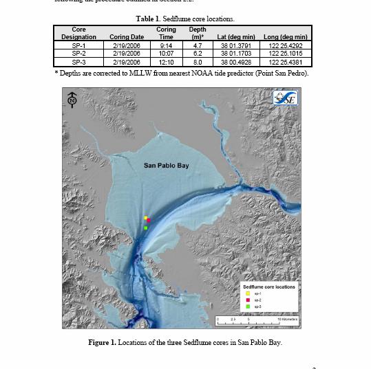
Sediment Transport in San Pablo Bay
 Chapter 2 Sediment Transport in San Pablo Bay By David H. Schoellhamer, Neil K. Ganju, and Gregory G. Shellenbarger Introduction San Pablo Bay is the northwestern subembayment of the San Francisco Estuary
UC Berkeley Technical Completion Reports
 UC Berkeley Technical Completion Reports Title Hydrodynamics of shallow water habitats in the Sacramento-San Joaquin Delta Permalink https://escholarship.org/uc/item/3j77h7t6 Author Stacey, Mark T Publication
Assessment of the Hood River Delta Hood River, Oregon
 Assessment of the Hood River Delta Hood River, Oregon Pacific Northwest Waterways Association Annual Meeting October 13, 2010 Michael McElwee, Executive Director Port of Hood River Overview U.S. Army Corps
Modeling Sediment Disposal in Inshore Waterways of British Columbia, Canada
 Modeling Sediment Disposal in Inshore Waterways of British Columbia, Canada Jianhua Jiang 1 and David B. Fissel 1 Abstract In support of the environmental assessment and regulatory approval process and
Appendix I. Dredged Volume Estimates. Draft Contractor Document: Subject to Continuing Agency Review
 Appendix I Dredged Volume Estimates Draft Contractor Document: Subject to Continuing Agency Review Interoffice Correspondence Date: April 6, 2007 To: L. Bossi (WHI) Copy: S. Thompson (WHI), B. Fidler (NNJ)
Main issues of Deltas
 Global sediment supply to coastal seas and oceans; location of major river deltas RIVER DELTAS Depositional processes - Course Coastal Morphodynamics GEO3-436; lecture 4 Nile Delta, Egypt Solo Delta, Java,
Technical Memorandum No
 Pajaro River Watershed Study in association with Technical Memorandum No. 1.2.10 Task: Evaluation of Four Watershed Conditions - Sediment To: PRWFPA Staff Working Group Prepared by: Gregory Morris and
RMA. Comparing Salinity and Hydrodynamics in the Historical and Contemporary Deltas
 Comparing Salinity and Hydrodynamics in the Historical and Contemporary Deltas Stephen Andrews, Ph.D. Ed Gross, Ph.D. John DeGeorge, Ph.D., P.E. Stacie Grinbergs, P.E. Outline Project Goals Model information
IS THERE ENOUGH SEDIMENT? Presentation at the State of the Estuary Conference San Francisco, CA, October 9-10, By Philip B.
 IS THERE ENOUGH SEDIMENT? Presentation at the State of the Estuary Conference San Francisco, CA, October 9-10, 2001 By Philip B. Williams 1. INTRO I AM TEMPTED TO MAKE THIS THE SHORTEST TALK OF THE CONFERENCE:
Freshwater-Tidal Gradients: Eco-geomorphology Linkages to Watershed-Estuarine Dynamics
 Freshwater-Tidal Gradients: Eco-geomorphology Linkages to Watershed-Estuarine Dynamics Kathy Boomer (The Nature Conservancy) Scott Ensign (Stroud Research) Greg Noe (USGS) Concluding Speculations: It s
Development and application of demonstration MIKE 21C morphological model for a bend in Mekong River
 Development and application of demonstration MIKE 21C morphological model for a bend in Mekong River September 2015 0 Table of Contents 1. Introduction... 2 2. Data collection... 3 2.1 Additional data...
Numerical modelling of morphological stability of proposed restoration measures along the Havel River
 Numerical modelling of morphological stability of proposed restoration measures along the Havel River Small scale morphological evolution of coastal, estuarine and rivers systems 6 7 October 2014, Nantes,
Historical Bathymetric Data for the Lower Passaic River
 Historical Bathymetric Data for the Lower Passaic River 4th Passaic River Symposium June 22nd, 2010 Dr. William Hansen Jeffrey Cranson Worcester State College Project Supported by The Hudson River Foundation
SHORELINE AND BEACH PROCESSES: PART 2. Implications for Coastal Engineering
 SHORELINE AND BEACH PROCESSES: PART 2 Implications for Coastal Engineering Objectives of the lecture: Part 2 Show examples of coastal engineering Discuss the practical difficulties of ocean engineering
9 th INTECOL Orlando, Florida June 7, 2012
 Restoration of the Everglades Saline Wetlands and Florida Bay: Responses Driven from Land and Sea David Rudnick 1, Colin Saunders 2, Carlos Coronado 2, Fred Sklar 2 Erik Stabenau 1, Vic Engel 1, Rene Price
Sediment Transport Modelling of Proposed Maintenance Dredging of the Outer and Inner Berths at the Aughinish Marine Terminal, Shannon Estuary
 Sediment Transport Modelling of Proposed Maintenance Dredging of the Outer and Inner Berths at the Aughinish Marine Terminal, Shannon Estuary Prepared for Malachy Walsh & Partners On behalf of Aughinish
Simulating the large-scale spatial sand-mud distribution in a schematized process-based tidal inlet system model
 DOI: 10.3990/2.196 Simulating the large-scale spatial sand-mud distribution in a schematized process-based tidal inlet system model F. Scheel1,2,3, M. van Ledden1,2, B.C. van Prooijen1 and M.J.F. Stive1
CHAPTER 28. PHYSIOGRAPHY Cook Inlet Drainages
 PEBBLE PROJECT ENVIRONMENTAL BASELINE DOCUMENT 2004 through 2008 CHAPTER 28. PHYSIOGRAPHY Cook Inlet Drainages PREPARED BY: Knight Piésold Ltd. PHYSIOGRAPHY COOK INLET DRAINAGES TABLE OF CONTENTS TABLE
An overview of USGS Hurricane Sandy Supplemental Studies along the Delmarva Peninsula
 An overview of USGS Hurricane Sandy Supplemental Studies along the Delmarva Peninsula Neil K. Ganju, Laura L. Brothers, Nathaniel G. Plant, Christopher G. Smith, E. Robert Thieler Coastal and Marine Geology
Elkhorn Slough Marsh Stratigraphy
 Elkhorn Slough Marsh Stratigraphy Prehistoric marsh extent & recent sediment accretion Elizabeth Burke Watson, Ph.D. U.S. Environmental Protection Agency Narragansett, RI Paleoecology: Reconstruction of
Temporal variability of partially-contaminated sediments in a strongly regulated reservoir of the upper Rhine River
 Temporal variability of partially-contaminated sediments in a strongly regulated reservoir of the upper Rhine River Germain Antoine 1,2,, Thomas Pretet 1,3,, Matthieu Secher 3,, and Anne Clutier 3, 1 Laboratoire
Seasonal Changes in the Mekong River Delta's Distributary Channels and Nearshore Sedimentary Environments
 DISTRIBUTION STATEMENT A. Approved for public release; distribution is unlimited. Seasonal Changes in the Mekong River Delta's Distributary Channels and Nearshore Sedimentary Environments Paul Liu & David
Mercury and methylmercury transport in the Cache Creek Settling Basin, California, U.S.A.
 Mercury and methylmercury transport in the Cache Creek Settling Basin, California, U.S.A. Alpers, C.N. 1, Fleck, J.A. 1, Marvin- DiPasquale, M. 2, Beaulieu, E. 1, and Wright, S.A. 1 1 U.S. Geological Survey,
Modelling of flow and sediment transport in rivers and freshwater deltas Peggy Zinke
 1 Modelling of flow and sediment transport in rivers and freshwater deltas Peggy Zinke with contributions from Norwegian and international project partners 2 Outline 1. Introduction 2. Basic ideas of flow
Sediment Connectivity and Exchange in Ameland Inlet
 Sediment Connectivity and Exchange in Ameland Inlet Stuart G. Pearson, Bram C. van Prooijen, Zheng Bing Wang, and Jasper P. Bak January 11 th, 2017 NCK Symposium on Sediment Sorting Study Site: Ameland
Dynamics of the Ems Estuary
 Dynamics of the Ems Estuary Physics of coastal systems Jerker Menninga 0439738 Utrecht University Institute for Marine and Atmospheric research Utrecht Lecturer: Prof. dr. H.E. de Swart Abstract During
Securing Manoeuverability of a Deep Draft Ship in a Sediment loaded Tidal River Berth
 Securing Manoeuverability of a Deep Draft Ship in a Sediment loaded Tidal River Berth O. Stoschek 1, A. Matheja 1 & C. Zimmermann 1 1 Franzius-Institute for Hydraulic, Waterways and Coastal Engineering,
Assessment of Water and Sediment Patterns within Prado Basin
 APPENDIX A Assessment of Water and Sediment Patterns within Prado Basin APPENDIX A Submitted To: Orange County Water District 18700 Ward Street Fountain Valley, California 92708 USA Submitted By: Golder
Texas A & M University and U.S. Bureau of Reclamation Hydrologic Modeling Inventory Model Description Form
 Texas A & M University and U.S. Bureau of Reclamation Hydrologic Modeling Inventory Model Description Form JUNE, 1999 Name of Model: Two-Dimensional Alluvial River and Floodplain Model (MIKE21 CHD & CST)
Marine Geosciences / Oceanography Fields and disciplines
 Marine Geosciences / Oceanography Fields and disciplines Marine Geosciences; Oceanography Chemical Oceanography Marine chemistry; marine geochemistry Biological Oceanography Marine biology; marine biogeochemistry
Technical Memorandum No Sediment Model
 Pajaro River Watershed Study in association with Technical Memorandum No. 1.2.9 Sediment Model Task: Development of Sediment Model To: PRWFPA Staff Working Group Prepared by: Gregory Morris and Elsie Parrilla
Sediment Stability in the Lower Passaic River Integration of Multiple Lines of Evidence
 Sediment Stability in the Lower Passaic River Integration of Multiple Lines of Evidence Fourth Passaic River Symposium June 22, 21 Michael Barbara, mab.consulting, LLC Marcia Greenblatt, AECOM John Connolly,
ABSTRACT. Keywords: Brunswick, dredged material, nearshore placement, PTM, sediment transport INTRODUCTION
 APPLICATION OF THE PARTICLE TRACKING MODEL TO PREDICT FAR-FIELD FATE OF SEDIMENT SUSPENDED BY NEARSHORE DREDGING AND PLACEMENT, BRUNSWICK GA Joseph Z. Gailani 1, Tahirih C. Lackey 1, and S. Jarrell Smith
Swift Creek Sediment Management Action Plan (SCSMAP)
") Swift Creek Sediment Management Action Plan (SCSMAP) PHASE 2 PROJECT PLAN PROPOSAL Whatcom County Public Works Department 322 N. Commercial Street, Suite 210 Bellingham, WA 98225 (360) 676-6692 June 2013
Swift Creek Sediment Management Action Plan (SCSMAP) PHASE 2 PROJECT PLAN PROPOSAL Whatcom County Public Works Department 322 N. Commercial Street, Suite 210 Bellingham, WA 98225 (360) 676-6692 June 2013
Sediment Dynamics in Restored Tidal Wetlands of San Francisco Bay
 Sediment Dynamics in Restored Tidal Wetlands of San Francisco Bay John Callaway & Jennifer Gagnon (USF) Lisa Schile (UC Berkeley) Evyan Borgnis & Tom Parker (SFSU) Donna Ball (HT Harvey & Assoc.) Gene
Coastal and Hydraulics Laboratory
 ERDC/CHL TR-09-6 Houston-Galveston Navigation Channels, Texas Project Navigation Channel Sedimentation Study, Phase 2 Plan Simulations Jennifer N. Tate and Cassandra G. Ross August 2009 Coastal and Hydraulics
SEDIMENT TRANSPORT IN RIVER MOUTH ESTUARY
 SEDIMENT TRANSPORT IN RIVER MOUTH ESTUARY Katsuhide YOKOYAMA, Dr.Eng. dredge Assistant Professor Department of Civil Engineering Tokyo Metropolitan University 1-1 Minami-Osawa Osawa, Hachioji,, Tokyo,
Optimal Design of Sediment Diversions for Delta Restoration: lessons learned from examples
 Optimal Design of Sediment Diversions for Delta Restoration: lessons learned from examples Samuel Bentley 1, Angelina Freeman 2, Clinton S. Willson 1, Liviu Giosan 3, Jaye Cable 4 1 LSU 2 EDF 3 WHOI 4
An Integrated Storm Surge, Hurricane Wave, Salinity and Sediment Transport Modeling System for Breton Sound, LA
 An Integrated Storm Surge, Hurricane Wave, Salinity and Sediment Transport Modeling System for Breton Sound, LA Q. Jim Chen Department of Civil and Environmental Engineering qchen@lsu.edu Acknowledgements
Heather Schlosser Army Corps of Engineers Coastal Studies Group August 28, 2008
 Got sand? Regional Sediment Management in Orange County Heather Schlosser Army Corps of Engineers Coastal Studies Group August 28, 2008 Regional Sediment Management Regional sediment management recognizes
The Effect of Statistical Abyssal Hill Roughness on the Generation of Internal Waves
 The Effect of Statistical Abyssal Hill Roughness on the Generation of Internal Waves Patrick G. Timko 1, Brian K. Arbic 1 John A. Goff 1 Center for Atmospheric and Oceanic Prediction Studies, Florida State
Comparing suspended sediment concentrations derived from a model and collected in a tidally dominated area
 Comparing suspended sediment concentrations derived from a model and collected in a tidally dominated area Maryam Rahbani, Department of oceanic and atmospheric science University of Hormozgan, maryamrahbani@yahoo.com
PREDICTION ON MORPHOLOGICAL RESPONSE OF DREDGED SAND-BORROW PITS. Qimiao Lu 1 and Robert B. Nairn 1
 PREDICTION ON MORPHOLOGICAL RESPONSE OF DREDGED SAND-BORROW PITS Qimiao Lu 1 and Robert B. Nairn 1 Dredged pits in coastal zones are generally required for sand borrows for beach nourishment. The morphological
BEFORE THE ENVIRONMENTAL PROTECTION AUTHORITY AT WELLINGTON
 BEFORE THE ENVIRONMENTAL PROTECTION AUTHORITY AT WELLINGTON IN THE MATTER of the Exclusive Economic Zone and Continental Shelf (Environmental Effects) Act 2012 (EEZ Act) AND IN THE MATTER BETWEEN AND AND
WIND EFFECTS ON CHEMICAL SPILL IN ST ANDREW BAY SYSTEM
 WIND EFFECTS ON CHEMICAL SPILL IN ST ANDREW BAY SYSTEM PETER C. CHU, PATRICE PAULY Naval Postgraduate School, Monterey, CA93943 STEVEN D. HAEGER Naval Oceanographic Office, Stennis Space Center MATHEW
M. MARVIN- DIPASQUALE B. JAFFE, J. ACKERMAN & G. SHELLENBARGER U.S. GEOLOGICAL SURVEY D. SLOTTON UNIV. CALIFORNIA - DAVIS
 MERCURY IN MOTION: An Examination of Mercury Mobilization and Transformation Associated With Wetland Restoration in South San Francisco Bay M. MARVIN- DIPASQUALE B. JAFFE, J. ACKERMAN & G. SHELLENBARGER
Importance of Understanding Coastal Landforms
 Importance of Understanding Coastal Landforms Costa Concordia Shipwreck, Isola del Giglio, Italy Depositional Coastal Landforms Can interpret landforms in light of geomorphic processes, both terrestrial
Shelf And Slope Sediment Transport In Strataform
 Shelf And Slope Sediment Transport In Strataform David A. Cacchione Woods Hole Group 1167 Oddstad Drive Redwood City, MA 94063 phone: 650-298-0520 fax: 650-298-0523 email: dcacchione@whgrp.com Award #:
Monitoring of sediment dynamics during disposal of dredged harbour sediment in Port of Esbjerg, Denmark
 Monitoring of sediment dynamics during disposal of dredged harbour sediment in Port of Esbjerg, Denmark Ulrik Lumborg, DHI Jacob Vested, DHI Signe Marie Ingvardsen, Kystdirektoratet Agenda Port of Esbjerg
West Galveston Bay Regional Sediment Management Plan (An Eco-geomorphologic Approach)
") West Galveston Bay Regional Sediment Management Plan (An Eco-geomorphologic Approach) Juan Moya, Matthew Mahoney and Mike Smith Restore America s Estuaries Conference Tampa, FL, October 23, 2012 Atkins
West Galveston Bay Regional Sediment Management Plan (An Eco-geomorphologic Approach) Juan Moya, Matthew Mahoney and Mike Smith Restore America s Estuaries Conference Tampa, FL, October 23, 2012 Atkins
Applying Gerris to Mixing and Sedimentation in Estuaries
 Applying Gerris to Mixing and Sedimentation in Estuaries Timothy R. Keen U.S. Naval Research Laboratory Stennis Space Center, Mississippi, U.S.A. 4 July 2011 Université Pierre et Marie Curie Paris, France
Field and Numerical Study of the Columbia River Mouth
 DISTRIBUTION STATEMENT A. Approved for public release; distribution is unlimited. Field and Numerical Study of the Columbia River Mouth Guy Gelfenbaum 400 Natural Bridges Dr. Santa Cruz, CA 95060 Phone:
Restoration of a boulder reef in Kattegat a numerical study of the design parameters and impact on sediment transport
 Restoration of a boulder reef in Kattegat a numerical study of the design parameters and impact on sediment transport S. Niemann, K. Bundgaard, et. al. DHI Water Environment Health, Denmark Boulder reef
Regional Sediment Management at East Rockaway Inlet, NY, Utilizing the USACE Coastal Modeling System
 Regional Sediment Management at East Rockaway Inlet, NY, Utilizing the USACE Coastal Modeling System by US Army Engineer District, New York PURPOSE: This Coastal and Hydraulics Engineering Technical Note
3.0 ROBERTS BANK TIDAL FLAT MORPHOLOGY
 Vancouver Port Authority Northwest Hydraulic Consultants Ltd. /Triton Consultants Ltd. Roberts Bank Container Expansion File: 33863 Coastal Geomorphology Study - 19 - November 2004 3.0 ROBERTS BANK TIDAL
Upper Truckee River Restoration Lake Tahoe, California Presented by Brendan Belby Sacramento, California
 Upper Truckee River Restoration Lake Tahoe, California Presented by Brendan Belby Sacramento, California Mike Rudd (Project Manager), Charley Miller & Chad Krofta Declines in Tahoe s Water Clarity The
ADH Sediment Module Testing
 ADH Sediment Module Testing By Jennifer N. Tate and R. C. Berger PURPOSE: The Kate Aubrey reach of the Mississippi River, located north of Memphis, TN, was used as a test domain for the ADaptive Hydraulics
Solutions to Flooding on Pescadero Creek Road
 Hydrology Hydraulics Geomorphology Design Field Services Photo courtesy Half Moon Bay Review Solutions to Flooding on Pescadero Creek Road Prepared for: San Mateo County Resource Conservation District
Decline of Lake Michigan-Huron Levels Caused by Erosion of the St. Clair River
 Decline of Lake Michigan-Huron Levels Caused by Erosion of the St. Clair River W.F. & Associates Coastal Engineers (in association with Frank Quinn) April 13, 2005 Outline Problem Definition Understanding
River Model (Delft3D)
") A Short River Model (Delft3D) & DIVERSION ANALYSIS presented by Nina J. Reins, PE, PhD, PMP State of the Coast May 30-June 1, 2018 Overview of Presentation Problem Statement & Background Analysis Key Findings
A Short River Model (Delft3D) & DIVERSION ANALYSIS presented by Nina J. Reins, PE, PhD, PMP State of the Coast May 30-June 1, 2018 Overview of Presentation Problem Statement & Background Analysis Key Findings