Morphological Modeling of Inlets and Adjacent Shorelines on Engineering Timescales
|
|
|
- Anissa Preston
- 5 years ago
- Views:
Transcription


1 CB&I Morphological Modeling of Inlets and Adjacent Shorelines on Engineering Timescales Challenges and Model Improvements based on Recent Studies Dobrochinski, J.P.H.; Benedet, L.; Signorin, M.; Pierro, T. CB&I Coastal & Maritime Services, 2481 NW Boca Raton Blvd, Boca Raton, FL, A World of Solutions
2 Outline 1. Inlet systems overview 2. Project cases general description North Topsail Beach, NC Blind Pass (Lee County, FL) 3. Use of numerical models Hydrodynamic and wave calibration Morphology calibration Model application / production runs 4. Conclusions A World of Solutions 1
3 Inlets systems Complex systems Tidal currents Waves Alongshore current and sediment drift Sediment bypassing (complex sediment paths) Multiple grain sizes Channel and ebb shoal relocation Coastal erosion/accretion A World of Solutions 2
4 Inlets systems Complex systems Tidal currents Process affect each other (inter-relations) Waves Alongshore current and sediment drift Sediment bypassing (complex sediment paths) Multiple grain sizes Coastal erosion/accretion (influence of channel location/orientation and ebb shoal) A World of Solutions 3
5 Project cases description A World of Solutions 4


6 Study areas A World of Solutions 5
7 North Topsail, NC (New River Inlet) A World of Solutions 6

8 Study areas North Topsail, NC ICWW North ICWW South New River Inlet A World of Solutions 7

9 Study areas North Topsail, NC Apr 2013 ~550,000 cy Authorized channel limits A World of Solutions 8

10 Study areas North Topsail, NC Apr 2014 Authorized channel limits A World of Solutions 9

11 Study areas North Topsail, NC Oct 2015 Authorized channel limits A World of Solutions 10

12 Study areas North Topsail, NC April 2013 Measured Bathymetry April 2014 April 2015 A World of Solutions 11
13 Blind Pass, FL (Lee County) A World of Solutions 12

14 Study areas Blind Pass, FL Blind Pass, Lee County (FL) Boca Grande Pass Captiva Pass Redfish Pass Blind Pass San Carlos Bay A World of Solutions 13
 Jun 2008 May")

15 Study areas Blind Pass, FL Blind Pass, Lee County (FL) Jun 2008 May 2002 Source: Captiva Erosion Prevention District A World of Solutions 14


16 Study areas Blind Pass, FL Blind Pass, Lee County (FL) ~150,000 cy A World of Solutions 15

")

17 Study areas Blind Pass, FL Blind Pass, Lee County (FL) A World of Solutions 16
18 Study areas - Summary Extremely dynamic and responsive environments challenging problems How to improve the situation, optimize project lifetime and expenses? alternate dredging layout, beach nourishment, hard structures, etc. (?) Support for decision making : a) Historical analysis of morphology changes b) Engineering analysis and sediment budgets c) Field surveys and measurements d) Numerical modeling e) Environmental resource mapping & impact assessments A World of Solutions 17
19 APPLICATIONS INPUTS Delft3D Overview General input Bathymetry, bed roughness, turbulence coefficients (viscosity) Boundary conditions Water levels, discharges / velocities, wind stress Delft3D-WAVE (Wind wave generation and propagation) State of the Art Morphology Modeling Delft3D-FLOW (3D currents, water levels) Morphology update Transport of Constituents (salinity, temperature, tracer, etc.) Particle tracking (oil spill, debris transport, etc.) Sediment transport (non-cohesive and cohesive) A World of Solutions 18
20 How the tool is applied Coastal Engineering Applications: 1) Hydrodynamic and wave model calibration 2) Morphology model calibration 3) Application - production runs A World of Solutions 19
21 How the tool is applied Coastal Engineering Applications: 1) Hydrodynamic and wave model calibration 2) Morphology model calibration 3) Application - production runs A World of Solutions 20


22 Flow and wave model A World of Solutions 21
23 How the tool is applied Coastal Engineering Applications: 1) Hydrodynamic and wave model calibration 2) Morphology model calibration 3) Application - production runs A World of Solutions 22
24 Morphology model calibration First challenge Computation time: 20 model days ~1 computer day 5*365 model days ~90 computer days! (longer term morphology) Wave, wind and tide input schematization required Selection of representative conditions - reproduce gross and net sediment transport - Mix wave conditions, avoid long repetitions, include the calm wave periods - Individual storms are/were relevant during calibration period (?) A World of Solutions 23
25 Morphology model calibration - Definition of calibration target (measured datasets for model verification) - Sediment budget - Alongshore volume change (erosion/sedimentation curves) - Morphology changes in the inlet - Morphology model (main) variables - Sediment transport formula (e.g. Van Rijn 1997, TRANSPOR 2004) - Cross shore sediment transport coefficients (i.e. SusW/BedW) - Bed roughness: bed forms and roughness predictor - Number and structure of vertical model layers: 3D flow structure and near-bed velocities - Horizontal eddy viscosity (flow) and diffusivity (transport) coefficients - Sediment mapping (3D measured data unavailable) and non-erodible layers - Transverse bed slope effect on transport (AlfaBn) TOTAL: >100 model runs How good is good enough? A World of Solutions 24
26 Examples of morphology calibration results North Topsail and Blind Pass Projects A World of Solutions 25
27 Volume change (1000*cy/yr) Calibration results - North Topsail CH1 CH2 IN1 IN2 IN3 Measured Simulated A World of Solutions 26

28 Calibration results - North Topsail Measured Simulated A World of Solutions 27
29 How the tool is applied Coastal Engineering Applications: 1) Hydrodynamic and wave model calibration 2) Morphology model calibration 3) Application - production runs A World of Solutions 28
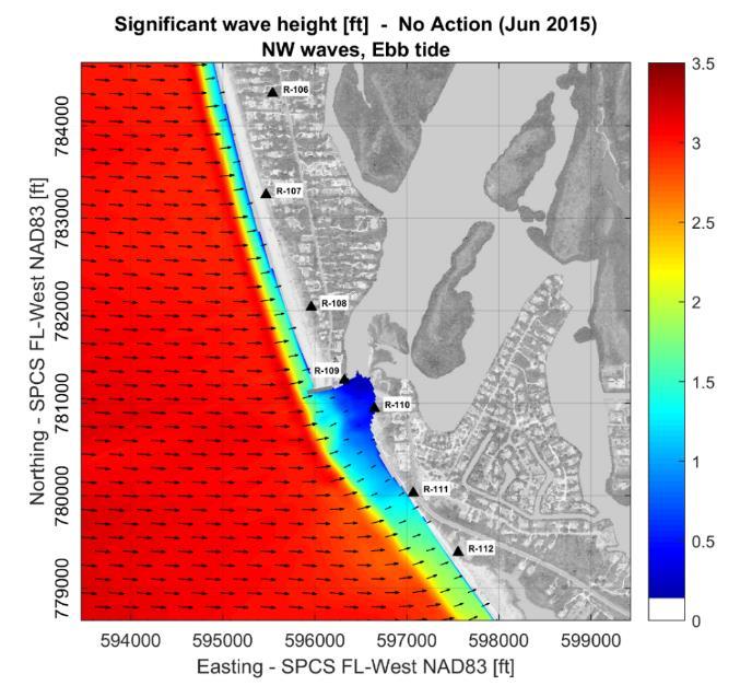
30 Application/production runs Calibrated model setup: Parameters Forcing scheme Base case simulation (usually No Action scenario) Several alternatives tested 1 5 year morphology simulations Storm simulations Analysis of absolute and relative results (benefits / impacts) A World of Solutions 29

31 Application/production runs A World of Solutions 30


32 Application/production runs Channel layouts Coastal structures and beach nourishment Blind Pass: under development A World of Solutions 31
33 Conclusions Tidal inlets + adjacent shorelines: extremely complex systems State-of-the-art morphological models (e.g. Delft3D) might supplement other analysis to: better understand beach/inlet changes assess the effects of engineering solutions Morphology calibration is essential for a solid application of the model Calibration target goals of the project Final/calibrated model setup: combination of several choices No general recipe or shortcuts to get there (experience builds up over the years) Good luck in your next morphology model application! A World of Solutions 32
34 A World of Solutions 33
The use of MIKE21 to study the. barrier beach system of Inner Dingle Bay, Co. Kerry, Ireland. Dr. Michael O Shea Malachy Walsh and Partners
 The use of MIKE21 to study the morphodynamic evolution of the mid-bay barrier beach system of Inner Dingle Bay, Co. Kerry, Ireland Dr. Michael O Shea Malachy Walsh and Partners Contents Why Study Morphodynamics
Sediment Connectivity and Exchange in Ameland Inlet
 Sediment Connectivity and Exchange in Ameland Inlet Stuart G. Pearson, Bram C. van Prooijen, Zheng Bing Wang, and Jasper P. Bak January 11 th, 2017 NCK Symposium on Sediment Sorting Study Site: Ameland
STORM IMPACT MODELING ANALYSIS FOR THE RESTORATION OF GULF STATE PARK, AL
 STORM IMPACT MODELING ANALYSIS FOR THE RESTORATION OF GULF STATE PARK, AL Jordon Cheifet, PE, CFM Joao Dobrochinski, MSc Morjana Signorin APTIM Senior Project Engineer APTIM Numerical Modeling Lead APTIM
MODELING OF EROSION CONTROL ALTERNATIVES AT STUMP PASS, CHARLOTTE COUNTY
 2014 NATIONAL CONFERENCE ON BEACH PRESERVATION TECHNOLOGY FEBRUARY 13, 2014 MODELING OF EROSION CONTROL ALTERNATIVES AT STUMP PASS, CHARLOTTE COUNTY 1 VADIM ALYMOV, PH.D. 2 CHUCK MOPPS 3 MICHAEL POFF,
PRESENTATION TITLE. Regional Sediment Management Application of a Coastal Model at the St. Johns River Entrance BUILDING STRONG
 PRESENTATION TITLE Regional Sediment Management Application of a Coastal Model at the St. Johns River Entrance Steven Bratos Senior Coastal Engineer U.S. Army Corps of Engineers Jacksonville District February
Mark H. Horwitz Ping Wang PhD Coastal Research Laboratory, School of Geosciences University of South Florida
 Mark H. Horwitz Ping Wang PhD Coastal Research Laboratory, School of Geosciences University of South Florida American Shore & Beach Preservation Association 2015 National Coastal Conference, New Orleans,
Pinellas, Manatee, and Sarasota Counties, Florida; Regional Sediment Budget
 Pinellas, Manatee, and Sarasota Counties, Florida; Regional Sediment Budget by Kelly R. Legault and Ashley E. Frey PURPOSE: This U.S. Army Corps of Engineers (USACE) Regional Sediment Management Technical
Coastal Sediment Properties and Longshore Sediment Transport
 Coastal Sediment Properties and Longshore Sediment Transport Julie Rosati Julie.D.Rosati@erdc.usace.army.mil 601-634-3005 Coastal Planning Course Lesson #8 Tuesday 8:00-9:00 am CEM III-1, III-2 1. Coastal
Nearshore Placement as a Regional Sediment Management Practice
 Nearshore Placement as a Regional Sediment Management Practice Katherine E. Brutsché, Ph.D. Brian C. McFall, Ph.D., P.E. Coastal and Hydraulics Laboratory US Army Engineer R&D Center ASBPA National Coastal
WIND EFFECTS ON CHEMICAL SPILL IN ST ANDREW BAY SYSTEM
 WIND EFFECTS ON CHEMICAL SPILL IN ST ANDREW BAY SYSTEM PETER C. CHU, PATRICE PAULY Naval Postgraduate School, Monterey, CA93943 STEVEN D. HAEGER Naval Oceanographic Office, Stennis Space Center MATHEW
Del Mar Sediment Management Study
 Del Mar Sediment Management Study Shoreline Preservation Working Group, June 7, 2018 Lindsey Sheehan Current work in Del Mar 2016 Sea-Level Rise Vulnerability Assessment 2018 Adaptation Plan 2018 Sediment
ENGINEERING APPROACHES TO SHORELINE PLACEMENT FROM COAST TO COAST
 ENGINEERING APPROACHES TO SHORELINE PLACEMENT FROM COAST TO COAST 237 237 237 217 217 217 200 200 200 0 0 0 163 163 163 131 132 122 80 119 27 252 174.59 83 36 118 110 135 120 112 92 56 62 102 130 Comparing
Decline of Lake Michigan-Huron Levels Caused by Erosion of the St. Clair River
 Decline of Lake Michigan-Huron Levels Caused by Erosion of the St. Clair River W.F. & Associates Coastal Engineers (in association with Frank Quinn) April 13, 2005 Outline Problem Definition Understanding
GenCade. Combining and Extending the GENESIS and Cascade Models for Planning and Design in a Regional Sediment Management Framework
 GenCade Combining and Extending the GENESIS and Cascade Models for Planning and Design in a Regional Sediment Management Framework G Presented by Nicholas C. Kraus For the GenCade Development Team Ken
Appendix O. Sediment Transport Modelling Technical Memorandum
 Appendix O Sediment Transport Modelling Technical Memorandum w w w. b a i r d. c o m Baird o c e a n s engineering l a k e s design r i v e r s science w a t e r s h e d s construction Final Report Don
Aquatic Transfer Facility (ATF) San Pablo Bay (SPB) Proposed Region of ATF. Proposed Seabed Pipeline
 San Pablo Bay (SPB) Proposed Region of ATF. Proposed Seabed Pipeline") Aquatic Transfer Facility (ATF) San Pablo Bay (SPB) Proposed Region of ATF Proposed Seabed Pipeline Technical Studies An Overview Scope: Provide background and new scientific information and analysis for
Aquatic Transfer Facility (ATF) San Pablo Bay (SPB) Proposed Region of ATF Proposed Seabed Pipeline Technical Studies An Overview Scope: Provide background and new scientific information and analysis for
Coastal Inlets Research Program US Army Corps of Engineers Engineering Research and Development Center
 Coastal Inlets Research Program US Army Corps of Engineers Engineering Research and Development Center Site of Moriches Inlet Nov. 1951 Julie Dean Rosati and Nicholas C. Kraus, CIRP Program Manager Shinnecock
Dynamics of the Ems Estuary
 Dynamics of the Ems Estuary Physics of coastal systems Jerker Menninga 0439738 Utrecht University Institute for Marine and Atmospheric research Utrecht Lecturer: Prof. dr. H.E. de Swart Abstract During
Hindcasting morphodynamic evolution with sand mud interactions in the Yangtze Estuary
 doi:10.5194/piahs-368-430-2015 430 Remote Sensing and GIS for Hydrology and Water Resources (IAHS Publ. 368, 2015) (Proceedings RSHS14 and ICGRHWE14, Guangzhou, China, August 2014). Hindcasting morphodynamic
Development, Testing and Application of the Multi-Block LTFATE Hydrodynamic and Sediment Transport Model
 Development, Testing and Application of the Multi-Block LTFATE Hydrodynamic and Sediment Transport Model Earl Hayter Environmental Lab October 25, 2012 LTFATE Multi-Block Hydrodynamic, Water Quality and
Regional Sediment Management at East Rockaway Inlet, NY, Utilizing the USACE Coastal Modeling System
 Regional Sediment Management at East Rockaway Inlet, NY, Utilizing the USACE Coastal Modeling System by US Army Engineer District, New York PURPOSE: This Coastal and Hydraulics Engineering Technical Note
Annual transport rates at two locations on the fore-slope.
 Sediment Transport by Currents Fore-slope Sediment transport rates and sediment concentrations were computed from the hydrodynamic model runs as well as from direct measurements of current velocities at
Coastal and Hydraulics Laboratory
 ERDC/CHL TR-12-14 Coastal Inlets Research Program Optimization of Ebb Shoal Mining and Beach Nourishment at St. Johns County, St. Augustine Inlet, Florida Report 3 Tanya M. Beck and Kelly Legault August
DIVISION OF COASTAL MANAGEMENT TO STUDY CURRENT LONG-TERM EROSION RATES ADJACENT TO TERMINAL GROINS
 DIVISION OF COASTAL MANAGEMENT TO STUDY CURRENT LONG-TERM EROSION RATES ADJACENT TO TERMINAL GROINS North Carolina Department of Environmental Quality Division of Coastal Management February 22, 2018 N.
SUBJECT INDEX. ~ ~5 physico-chemical properties 254,255 Redox potential 254,255
 Aggregates: beds formed by deposition 81,82 breakup by fluid shear, introduction 85,86 deposition from flowing water 80 implications in cohesive sediment transport 102-105 needs for further research 83
SHORELINE AND BEACH PROCESSES: PART 2. Implications for Coastal Engineering
 SHORELINE AND BEACH PROCESSES: PART 2 Implications for Coastal Engineering Objectives of the lecture: Part 2 Show examples of coastal engineering Discuss the practical difficulties of ocean engineering
MORPHOLOGICAL MODELLING OF ARTIFICIAL SAND RIDGE NEAR HOEK VAN HOLLAND, THE NETHERLANDS. L.C. van Rijn, D.J.R. Walstra and P.K.
 MORPHOLOGICAL MODELLING OF ARTIFICIAL SAND RIDGE NEAR HOEK VAN HOLLAND, THE NETHERLANDS L.C. van Rijn, D.J.R. Walstra and P.K. Tonnon Delft Hydraulics, P.O. Box 177, 2700 MH Delft, The Netherlands. leo.vanrijn@wldelft.nl
Hauraki regional harbour model : set-up calibration and verification
 Hauraki regional harbour model : set-up calibration and verification August 2004 TP238 Auckland Regional Council Technical Publication 238, August 2004 ISSN 1175 205X ISBN 1-877353-52-3 Printed on recycled
Securing Manoeuverability of a Deep Draft Ship in a Sediment loaded Tidal River Berth
 Securing Manoeuverability of a Deep Draft Ship in a Sediment loaded Tidal River Berth O. Stoschek 1, A. Matheja 1 & C. Zimmermann 1 1 Franzius-Institute for Hydraulic, Waterways and Coastal Engineering,
Process-based Long Term Morphological Modelling the present state-of-the-art and the way ahead. Dirk-Jan Walstra
 Process-based Long Term Morphological Modelling the present state-of-the-art and the way ahead Dirk-Jan Walstra Deltares Delft Hydraulics Delft University of Technology Les littoraux à l heure du changement
Assessing Storm Tide Hazard for the North-West Coast of Australia using an Integrated High-Resolution Model System
 Assessing Storm Tide Hazard for the North-West Coast of Australia using an Integrated High-Resolution Model System J. Churchill, D. Taylor, J. Burston, J. Dent September 14, 2017, Presenter Jim Churchill
EXAMPLES (SEDIMENT TRANSPORT) AUTUMN 2018
 AUTUMN 2018") EXAMPLES (SEDIMENT TRANSPORT) AUTUMN 2018 Q1. Using Cheng s formula estimate the settling velocity of a sand particle of diameter 1 mm in: (a) air; (b) water. Q2. Find the critical Shields parameter diameter
EXAMPLES (SEDIMENT TRANSPORT) AUTUMN 2018 Q1. Using Cheng s formula estimate the settling velocity of a sand particle of diameter 1 mm in: (a) air; (b) water. Q2. Find the critical Shields parameter diameter
SEGMENTED BREAKWATERS AND THEIR USE IN COASTAL LOUISIANA
 SEGMENTED BREAKWATERS AND THEIR USE IN COASTAL LOUISIANA Prepared by: Louisiana Coastal Protection and Restoration Authority Engineering Division March 2016 The geology of Louisiana s coastal zone is intimately
Simulating the large-scale spatial sand-mud distribution in a schematized process-based tidal inlet system model
 DOI: 10.3990/2.196 Simulating the large-scale spatial sand-mud distribution in a schematized process-based tidal inlet system model F. Scheel1,2,3, M. van Ledden1,2, B.C. van Prooijen1 and M.J.F. Stive1
INFLUENCE OF INLET / SHOAL COMPLEX ON ADJACENT SHORELINES VIA INLET SINK METHOD
 INFLUENCE OF INLET / SHOAL COMPLEX ON ADJACENT SHORELINES VIA INLET SINK METHOD Kelly R. Legault, Ph.D., P.E. 1, Tanya M. Beck 2 and Jason A. Engle, P.E. 3 The region of influence of the inlet on the adjacent
The U.S. Army Corps of Engineers Philadelphia District
 The U.S. Army Corps of Engineers Philadelphia District The Atlantic Coast of New Jersey Regional Sediment Budget 1986-2003 Cape May Point to Manasquan Inlet Final Report March 2006 The Atlantic Coast of
Probabilistic Evaluation of a Meandering Low-Flow Channel. February 24 th, UMSRS
 Probabilistic Evaluation of a Meandering Low-Flow Channel February 24 th, 2014 2014 UMSRS 1 2 acknowledgments Low- Flow Channel (LFC) overview Proposed Diversion Channel collects runoff from: The Rush
Mapping of Future Coastal Hazards. for Southern California. January 7th, David Revell, Ph.D. E.
 Mapping of Future Coastal Hazards for Southern California January 7th, 2014 David Revell, Ph.D. drevell@esassoc.com E. Vandebroek, 2012 Outline Coastal erosion hazard zones Flood hazard zones: Coastal
2 MATERIALS AND METHODS
 2 MATERIALS AND METHODS 2.1. Sand Movement on Coral Cays Sand movement in Semak Daun cay was recognized by the monsoonal morphological change of the beach line. It is found that certain beach lines advanced
ERDC Update SAD Regional Management Board
 ERDC Update SAD Regional Management Board José E. Sanchez, P.E., SES Director, Coastal and Hydraulics Laboratory Engineer Research and Development Center 14FEB17 Overview of R&D Activities in AOR Cross
Sea-level Rise on Cape Cod: How Vulnerable Are We? Rob Thieler U.S. Geological Survey Woods Hole, MA
 Sea-level Rise on Cape Cod: How Vulnerable Are We? Rob Thieler U.S. Geological Survey Woods Hole, MA Outline Sea-level and coastal processes Past sea-level change Predictions for the future Coastal responses
Holderness Erosion and Evolution of the Spurn Peninsula
 Holderness Erosion and Evolution of the Spurn Peninsula Prof. Ken Pye and Dr. Simon Blott Kenneth Pye Associates Ltd. Outline of the Presentation Overview of historical erosion trends Effects of coast
LONG-TERM MORPHOLOGICAL MODELING AT COASTAL INLETS
 1 LONG-TERM MORPHOLOGICAL MODELING AT COASTAL INLETS ALEJANDRO SANCHEZ 1, MITCHELL BROWN 2, TANYA BECK 3, RICHARD STYLES 4, HONGHAI LI 5 1. U.S. Army Engineer Research and Development Center,, 3909 Halls
6.0 SEDIMENT TRANSPORT
 Coastal Geomorphology Study - 74 - November 2004 6.0 SEDIMENT TRANSPORT 6.1 SEDIMENT CHARACTERISTICS 6.1.1 Bed Sediment Properties The size distribution of sediments on Roberts Bank was determined using
EAST PASS UP-DATE SUMMARY OF FINDINGS REPORT and INLET MANAGEMENT IMPLEMENTATION PLAN
 EAST PASS 2013 UP-DATE SUMMARY OF FINDINGS REPORT and INLET MANAGEMENT IMPLEMENTATION PLAN Introduction On June 8, 2000, the Florida Department of Environmental Protection adopted the East Pass Inlet Management
Unified View of Sediment Transport by Currents and Waves. IV: Application of Morphodynamic Model
 Unified View of Sediment Transport by Currents and Waves. IV: Application of Morphodynamic Model Leo C. van Rijn 1 ; Dirk-Jan R. Walstra 2 ; and Maarten van Ormondt 3 Abstract: The TR2004 transport formulations
Supplemental Slides. Shore: Junction of Land & Water. Junction of Land & Water. Sea Level Variations. Shore vs. Coast. Sea Level Variations
 Shore: Junction of Land & Water Supplemental Slides Sediments come off land Most get dumped at the beach Sediment interacts with ocean waves and currents Junction of Land & Water Features: Breaking waves,
Shore: Junction of Land & Water. Sediments come off land Most get dumped at the beach Sediment interacts with ocean waves and currents
 Shore: Junction of Land & Water Supplemental Slides Sediments come off land Most get dumped at the beach Sediment interacts with ocean waves and currents Junction of Land & Water Features: Breaking waves,
Prediction of changes in tidal system and deltas at Nakdong estuary due to construction of Busan new port
 Prediction of changes in tidal system and deltas at Nakdong estuary due to construction of Busan new port H. Gm1 & G.-Y. park2 l Department of Civil & Environmental Engineering, Kookmin University, Korea
Research Topic Updated on Oct. 9, 2014
 Research Topic Updated on Oct. 9, 204 Mixed Cohesive/Non-cohesive Sediments Sedimentation in Estuary: Flocculation Deposition Erosion Transport Consolidation *: It has been recognized that when the fraction
Applying Gerris to Mixing and Sedimentation in Estuaries
 Applying Gerris to Mixing and Sedimentation in Estuaries Timothy R. Keen U.S. Naval Research Laboratory Stennis Space Center, Mississippi, U.S.A. 4 July 2011 Université Pierre et Marie Curie Paris, France
Linking Inlet Hydrodynamics and Morphologic Response at Oregon Inlet, NC
 Linking Inlet Hydrodynamics and Morphologic Response at Oregon Inlet, NC Prepared for: Sharon Ahlers Engineering Communications Program Cornell University Prepared by: Justin Vandever School of Civil and
A SEDIMENT BUDGET ANALYSIS AND MANAGEMENT STRATEGY FOR FORT PIERCE INLET, FL
 A SEDIMENT BUDGET ANALYSIS AND MANAGEMENT STRATEGY FOR FORT PIERCE INLET, FL By Elba Rodriguez and Robert G. Dean Department of Civil and Coastal Engineering University of Florida Gainesville, FL 32611,
Material Workshop. Galveston District 2012 Beneficial Use of Dredged. Material Workshop. Custodians of the Coast
 Galveston District 2012 Beneficial Use of Dredged Material Workshop Galveston District 2012 Beneficial Use of Dredged Material Workshop US Army Corps of Engineers BUILDING STRONG Welcome Opening Remarks
Restored oyster reefs enhance estuarine ecosystem services by altering nearshore salinity
 Restored oyster reefs enhance estuarine ecosystem services by altering nearshore salinity Photo: UF/IFAS David Kaplan, Maitane Olabarrieta, Peter Frederick, and Arnoldo Valle-Levinson Globally: Most Threatened
MISSISSIPPI COASTAL IMPROVEMENTS
 MISSISSIPPI COASTAL IMPROVEMENTS PROGRAM (MsCIP) Comprehensive Barrier 237 27 200 237 27 200 Island 237 Restoration 27 200 Plan 80 9 27 252 74.59 255 255 255 0 0 0 63 63 63 3 32 22 239 65 53 0 35 20 2
Appendix G.19 Hatch Report Pacific NorthWest LNG Lelu Island LNG Maintenance Dredging at the Materials Offloading Facility
 Appendix G.19 Hatch Report Pacific NorthWest LNG Lelu Island LNG Maintenance Dredging at the Materials Offloading Facility Project Memo H345670 To: Capt. David Kyle From: O. Sayao/L. Absalonsen December
Effects of possible land reclamation projects on siltation in the Rotterdam harbour area. A model study.
 Effects of possible land reclamation projects on siltation in the Rotterdam harbour area. A model study. J.M. de Kok
Lu, S., P. Craig, C. Wallen, Z. Liu, A. Stoddard, W. McAnnally and E. Maak. Dynamic Solutions, Knoxville, TN USACOE, Sacramento District
 An Extended-Delta Hydrodynamic Model Framework for Sea Level Rise Analysis to Support Resource Management Planning for the Sacramento-San Joaquin River Delta Lu, S., P. Craig, C. Wallen, Z. Liu, A. Stoddard,
Modeling the North West European Shelf using Delft3D Flexible Mesh
 Modeling the North West European Shelf using Delft3D Flexible Mesh 2nd JCOMM Scientific and Technical Symposium on Storm Surges, 8-13 Nov. 2015, Key West, USA; Firmijn Zijl Outline of this presentation
DESIGN ENGINEERING ANALYSIS FOR TERMINAL GROIN LENGTH
 APPENDIX I DESIGN ENGINEERING ANALYSIS FOR TERMINAL GROIN LENGTH (Prepared by Olsen Associates, Inc.) Final Environmental Impact Statement Village of Bald Head Island Shoreline Protection Project Brunswick
SEDIMENT IMPORT BY TIDAL INLETS SEDBOX -model for tidal inlets Marsdiep and Vlie, Wadden sea, The Netherlands by L.C. van Rijn
 SEDIMENT IMPORT BY TIDAL INLETS SEDBOX -model for tidal inlets Marsdiep and Vlie, Wadden sea, The Netherlands by L.C. van Rijn 1. Physical processes of sandy tidal inlet systems 1.1 Introduction 1.2 Hydrodynamics
Primer on Coastal Erosion And Habitat Creation
 2 nd Regional Conference Dredging, Beach Nourishment & Bird Conservation Primer on Coastal Erosion And Habitat Creation Timothy Kana Ph.D Source: Newsday 1962 Photo by Kelsey Aerials 1978 Source: U Mass
SAVANNAH HARBOR EXPANSION BANK EROSION STUDY UPDATE
 CESAS-EN-GS SAVANNAH HARBOR EXPANSION BANK EROSION STUDY UPDATE GEOTECHNICAL AND HTRW BRANCH SOILS SECTION CITY FRONT, BIGHT SECTION, FORT PULASKI & NORTH TYBEE ISLAND GEORGIA 23 June 2011 CESAW-TS-EG
Field and Numerical Study of the Columbia River Mouth
 DISTRIBUTION STATEMENT A. Approved for public release; distribution is unlimited. Field and Numerical Study of the Columbia River Mouth Guy Gelfenbaum 400 Natural Bridges Dr. Santa Cruz, CA 95060 Phone:
Coastal Flood Risk Study Project for East Coast Central Florida Study Area
 Coastal Flood Risk Study Project for East Coast Central Florida Study Area St Lucie County, Florida Flood Risk Review Meeting March 28, 2017 Introductions Risk MAP Project Team FEMA Region IV BakerAECOM,
Texas A & M University and U.S. Bureau of Reclamation Hydrologic Modeling Inventory Model Description Form
 Texas A & M University and U.S. Bureau of Reclamation Hydrologic Modeling Inventory Model Description Form JUNE, 1999 Name of Model: Two-Dimensional Alluvial River and Floodplain Model (MIKE21 CHD & CST)
Donald K. Stauble and Bill Birkemeier Coastal and Hydraulics Laboratory US Army Corps of Engineers
 Donald K. Stauble and Bill Birkemeier Coastal and Hydraulics Laboratory US Army Corps of Engineers Define the Problem Navigation Shore Protection Environmental Political So what is the problem? Management
COASTAL SEDIMENT BUDGET FOR JUPITER INLET, FLORIDA
 COASTAL SEDIMENT BUDGET FOR JUPITER INLET, FLORIDA By KRISTEN MARIE ODRONIEC A THESIS PRESENTED TO THE GRADUATE SCHOOL OF THE UNIVERSITY OF FLORIDA IN PARTIAL FULFILLMENT OF THE REQUIREMENTS FOR THE DEGREE
Assessment of the performance of a turbulence closure model: along the tidally-influenced Kaipara River to the estuary, NZ
 Assessment of the performance of a turbulence closure model: along the tidally-influenced Kaipara River to the estuary, NZ Berengere S. Dejeans 1, Julia C. Mullarney 2, Iain T. MacDonald 3 and Glen M.
Application of Mathematical Model to Assess Sediment Movement Pattern along Nearshore Coastal Water
 Journal of Earth Science and Engineering 6 (2016) 177-182 doi: 10.17265/2159-581X/2016.03.004 D DAVID PUBLISHING Application of Mathematical Model to Assess Sediment Movement Pattern along Sumaya Hossain
Sediment Traps. CAG Meeting May 21, 2012
 Sediment Traps CAG Meeting May 21, 2012 Agenda Background Fundamentals of Sediment Transport Sediment Trap Existing Information Next Steps 2 The Site Saginaw River 22 mile river beginning at confluence
PTM: A Lagrangian Particle Tracking Model. Joseph Gailani
 PTM: A Lagrangian Particle Tracking Model Joseph Gailani Joe.Z.Gailani@usace.army.mil OUTLINE Motivation for sediment/constituent modeling system Objectives of modeling system Description of PTM PTM Example
COASTAL DATA APPLICATION
 2015 Coastal GeoTools Proactive By Design. Our Company Commitment COASTAL DATA APPLICATION Projecting Future Coastal Flood Risk for Massachusetts Bay Bin Wang, Tianyi Liu, Daniel Stapleton & Michael Mobile
Appendix G.18 Hatch Report Pacific NorthWest LNG Lelu Island LNG Potential Impacts of the Marine Structures on the Hydrodynamics and Sedimentation
 Appendix G.18 Hatch Report Pacific NorthWest LNG Lelu Island LNG Potential Impacts of the Marine Structures on the Hydrodynamics and Sedimentation Patterns Project Memo H345670 To: Capt. David Kyle From:
Beach Nourishment on the Florida East Coast. Boca Raton
 Beach Nourishment on the Florida East Coast Past Future Boca Raton Erosion is the Main Reason for Beach Past - Erosion on the east coast was mainly caused by inlets created or modified for navigation Nourishment
PREDICTION ON MORPHOLOGICAL RESPONSE OF DREDGED SAND-BORROW PITS. Qimiao Lu 1 and Robert B. Nairn 1
 PREDICTION ON MORPHOLOGICAL RESPONSE OF DREDGED SAND-BORROW PITS Qimiao Lu 1 and Robert B. Nairn 1 Dredged pits in coastal zones are generally required for sand borrows for beach nourishment. The morphological
ST. JOHNS COUNTY, FLORIDA South Ponte Vedra Beach, Vilano Beach, and Summer Haven Reaches
 ST. JOHNS COUNTY, FLORIDA South Ponte Vedra Beach, Vilano Beach, and Summer Haven Reaches COASTAL STORM RISK MANAGEMENT PROJECT DRAFT INTEGRATED FEASIBILITY STUDY AND ENVIRONMENTAL ASSESSMENT APPENDIX
Webinar on PTM with CMS
 Webinar on PTM with CMS Honghai Li Research Physical Scientist Mitchell E. Brown Civil Engineering Technician Engineer Research and Development Center CMS December 4, 2013 US Army Corps of Engineers BUILDING
Jun Cheng School of Geosciences, University of South Florida 4202 E. Fowler Ave., NES 117, Tampa, FL 33620
 EDUCATION Jun Cheng 4202 E. Fowler Ave., NES 117, Tampa, FL 33620 Phone: 813-974-2759 Email: jun@mail.usf.ed University of South Florida (Tampa, FL) Ph.D. in Geology, 2015 Dissertation: Multiple Scale
Coastal Barrier Island Network (CBIN): Management strategies for the future
: Management strategies for the future") Coastal Barrier Island Network (CBIN): Management strategies for the future Heather Joesting*, Amy Williams**, Rusty Feagin**, and William K. Smith* *Department of Biology, Wake Forest University, Winston
Coastal Barrier Island Network (CBIN): Management strategies for the future Heather Joesting*, Amy Williams**, Rusty Feagin**, and William K. Smith* *Department of Biology, Wake Forest University, Winston
Mississippi River West Bay Diversion Geomorphic Assessment and 1-D Modeling Plan
 Mississippi River West Bay Diversion Geomorphic Assessment and 1-D Modeling Plan Freddie Pinkard and Charlie Little Research Hydraulic Engineers ERDC-CHL-River Engineering Branch 27 February 2009 Lane
Towards prediction of fines captures
 Towards prediction of fines captures over the wide range of depositional environments occurring simultaneously in a typical facility Luca Sittoni, Jill Hanssen, Hugo van Es, Jan van Kester, Rob Uittenbogaard,
MODELLING OF SEDIMENTATION OF DREDGED TRENCHES AND CHANNELS UNDER THE COMBINED ACTION OF TIDAL CURRENTS AND WAVES
 MODELLING OF SEDIMENTATION OF DREDGED TRENCHES AND CHANNELS UNDER THE COMBINED ACTION OF TIDAL CURRENTS AND WAVES D.J.R. Walstra 1, L.C. Van Rijn 1, S.E. Hoogewoning 2, S.G.J. Aarninkhof 1 Abstract: The
Geology Setting Management Options Management Structure
 Geology Setting Management Options Management Structure WFF = Wallops Flight Facility LST = Longshore sediment transport SLR = Sea level rise September 29, 2015 Accomack County/Accomack Northampton County
ΛTKINS. Applications of Regional Sediment Management Concepts in Texas Estuarine Restoration Projects. Riparian Workshop Fort Worth, October 17, 2012
 Juan C Moya, PhD., PG Coastal Planning and Restoration Applications of Regional Sediment Management Concepts in Texas Estuarine Restoration Projects Riparian Workshop Fort Worth, October 17, 2012 West
Appendix I. Dredged Volume Estimates. Draft Contractor Document: Subject to Continuing Agency Review
 Appendix I Dredged Volume Estimates Draft Contractor Document: Subject to Continuing Agency Review Interoffice Correspondence Date: April 6, 2007 To: L. Bossi (WHI) Copy: S. Thompson (WHI), B. Fidler (NNJ)
Environmental concerns for marina planning in the Gulf of Suez
 Journal of Coastal Conservation 6: 51-56, 2000 EUCC; Opulus Press Uppsala. Printed in Sweden - Environmental concerns for marina planning in the Gulf of Suez - 51 Environmental concerns for marina planning
The Sediment Budget Calculator: A Webtool to Develop a Family of Viable Inlet and Adjacent Beach Sediment Budget Solutions
 The Sediment Budget Calculator: A Webtool to Develop a Family of Viable Inlet and Adjacent Beach Sediment Budget Solutions by Julie Dean Rosati, Charles A. Sumner, and Derek A. Wilson PURPOSE: This Coastal
DESIGN ENGINEERING ANALYSIS FOR TERMINAL GROIN LENGTH
 APPENDIX F DESIGN ENGINEERING ANALYSIS FOR TERMINAL GROIN LENGTH (Prepared by Olsen Associates, Inc.) DRAFT Environmental Impact Statement Village of Bald Head Island Shoreline Protection Project Brunswick
ENGINEERING WITH NATURE: NEARSHORE BERM PLACEMENTS AT FORT MYERS BEACH AND PERDIDO KEY, FLORIDA, USA
 1 ENGINEERING WITH NATURE: NEARSHORE BERM PLACEMENTS AT FORT MYERS BEACH AND PERDIDO KEY, FLORIDA, USA KATHERINE E. BRUTSCHÉ 1, PING WANG 2, JULIE D. ROSATI 1, CHERYL E. POLLOCK 1 1. U.S. Army Engineer
CHAPTER 126 ^^^C^SR, SEDIMENTATION STUDIES ON THE NIGER RIVER DELTA
 CHAPTER 126 SEDIMENTATION STUDIES ON THE NIGER RIVER DELTA Ramiro Mayor-Mora, D. Eng. (1) Preben Mortensen, M.Sc. (2) Jorgen Fredsoe, M.Sc. (2) 1. Introduction An area of the Niger River Delta was studied
EVALUATION OF THE RELATIONSHIPS BETWEEN NAVIGATION CHANNEL DREDGING AND EROSION OF ADJACENT BEACHES IN SOUTHERN BRAZIL
 EVALUATION OF THE RELATIONSHIPS BETWEEN NAVIGATION CHANNEL DREDGING AND EROSION OF ADJACENT BEACHES IN SOUTHERN BRAZIL Lucas Silveira 1 ;Lindino Benedet 2 ; Morjana Signorin 3 and Rafael Bonanata 4 São
Numerical Study To Enhance Stability Condition Within The River Mouth; Case Study: Rosetta Promontory, Egypt
 City University of New York (CUNY) CUNY Academic Works International Conference on Hydroinformatics 8-1-2014 Numerical Study To Enhance Stability Condition Within The River Mouth; Case Study: Rosetta Promontory,
Fluvial Processes in River Engineering
 Fluvial Processes in River Engineering Howard H. Chang San Diego State University... A WILEY-INTERSCIENCE PUBLTCATION John Wiley & Sons New York Chicbester Brisbane Toronto Singapore CONTENTS PARTI FLUVIAL
DRIVEN LARVAL TRANSPORT ON SALEH BAY, SUMBAWA, INDONESIA *)
") BAROTROPIC TIDAL AND WIND-DRIVEN DRIVEN LARVAL TRANSPORT ON SALEH BAY, SUMBAWA, INDONESIA *) Widodo S. Pranowo 1), Yulia Herdiani 2) Ivonne M. Radjawane 3) 2), *) Presenting on WOM-12 APEC/MRC/OMISAR in
BAROTROPIC TIDAL AND WIND-DRIVEN DRIVEN LARVAL TRANSPORT ON SALEH BAY, SUMBAWA, INDONESIA *) Widodo S. Pranowo 1), Yulia Herdiani 2) Ivonne M. Radjawane 3) 2), *) Presenting on WOM-12 APEC/MRC/OMISAR in
River Model (Delft3D)
") A Short River Model (Delft3D) & DIVERSION ANALYSIS presented by Nina J. Reins, PE, PhD, PMP State of the Coast May 30-June 1, 2018 Overview of Presentation Problem Statement & Background Analysis Key Findings
A Short River Model (Delft3D) & DIVERSION ANALYSIS presented by Nina J. Reins, PE, PhD, PMP State of the Coast May 30-June 1, 2018 Overview of Presentation Problem Statement & Background Analysis Key Findings
Sediment Management in the Coastal Bays
 Sediment Management in the Coastal Bays Introduction Need for ecosystem view of sediment management in Coastal Bays Island loss and restoration Navigation needs Habitat Trade offs Living Shoreline Requirements
L7/ Historical Perspec=ve, Deltas
 Colin Woodroffe (2002) Coasts: Form, Process and Evolu=on, Outline of Chapter 7: L7/1 L7/2 7.1. Historical Perspec=ve, 7.1.1. Deltas Herodotus (450, B.C.) delta = Shape of Nile River Delta = Δ Gilbert