An Integrated Storm Surge, Hurricane Wave, Salinity and Sediment Transport Modeling System for Breton Sound, LA
|
|
|
- Kristopher Norton
- 5 years ago
- Views:
Transcription
1 An Integrated Storm Surge, Hurricane Wave, Salinity and Sediment Transport Modeling System for Breton Sound, LA Q. Jim Chen Department of Civil and Environmental Engineering
 Pat")
 John Pardue, Clint Willson,")
2 Acknowledgements Haihong Zhao, Kelin Hu (LSU/CEE) Robert Twilley, Jaye Cable (LSU, Co-PI) Pat Fitzpatrick (MSU, Co-PI) Hendrik Tolman (NOAA/NCEP, CO-PI) John Pardue, Clint Willson, Greg Zhang Funding

3 Objective Develop a computer modeling system to predict storm surges, hurricane waves, and corresponding wetland erosion and sedimentation in Breton Sound and Wax Lake Delta. Transport models: Sediment Salinity Oil slicks


4 Study Area Lake Pontchartrain Caernarvon Marsh Biloxi Marsh Chandeleur Island Mississippi River

 41 Deciduous Forest 42 Evergreen Forest")


5 Vegetation Coverage (NLCD) NLCD Class # NLCD Class Name Marshes Legend Open Water 21 Developed - Open Space 22 Developed Low Intensity 23 Developed Medium Intensity 24 Developed Medium Intensity 31 Barren Land (Rock/Sand/Clay) 41 Deciduous Forest 42 Evergreen Forest 43 Mixed Forest 52 Shrub/Scrub 71 Grassland/Herbaceous 81 Pasture/Hay 82 Cultivated Crops 90 Woody Wetlands 95 Emergent Herbaceous Wetlands In Louisiana GAP analysis project, #95 is classified as Brackish marsh with Manning s coefficient of and at the seaward edge saline marsh is distributed but not indicated in NLCD database.
 Plant Density (number/m 2 ) Stem")

6 Marsh Properties Sampling Site Breton Sound (August, 2009) Terrebonne Bay (December, 2009) Plant Density (number/m 2 ) Stem Height (m) / (Stem Diameter (mm)) Bending Stiffness EI (N m 2 ) / / Breton Sound Terrebonne Bay
 US")

7 Bottom Sediment (LASeabed) LA Seabed (Tulip Pink) US Seabed (Aster Purple) Including: Sand%, Mud%, Clay% and D 50
8 Latitude (degrees) Hurricane Katrina (H*WIND) Hurricane Katrina 2005 coastline track tropical storm hurricane Longitude (degrees)

")
9 Fall 2004 ~ Fall 2006 Impact of Hurricane Katrina Basin Mississippi River Delta Breton Sound Pontchartrain Pearl River Period Class Mi 2 Km 2 Mi 2 Km 2 Mi 2 Km 2 Mi 2 Km 2 Net Land Area Change Flooded Burned Marsh Flooded Ag/Pasture Impoundment Adjusted Net Land Area Change Land Area Change in Coastal Louisiana After the 2005 Hurricanes: Overview (Barras, 2006)
10 Methodology Numerical Models Storm surge model (ADCIRC) 3D circulation model (Modified ECOM3D) Spectral wave model (SWAN w/ vegetation) Sediment transport model (SED vegetation) Satellite Images Estimated the increase of water area by comparing LANDSAT imagery before/after the storm (Barras 2006)
11 Hot start after 30 days of tide simulation Mesh:SL15v71 ADCIRC (2.4M nodes, 4.7M elements) Time step: 1s Open boundary 7 tidal constituents (K1, O1, Q1,N2, M2, S2 and K2) Parallel run on 800 cores for 12 days simulation (Aug 27 ~ Sep 7, 2008)
 Time step: 1s Open boundary 7 tidal constituents (K1, O1, Q1,N2, M2, S2 and K2) Parallel run on 800 cores")
12 Hot start after 30 days of tide simulation Mesh:SL15v71 ADCIRC (2.4M nodes, 4.7M elements) Time step: 1s Open boundary 7 tidal constituents (K1, O1, Q1,N2, M2, S2 and K2) Parallel run on 800 cores for 12 days simulation (Aug 27 ~ Sep 7, 2008)
13 Numerical Modeling System Wind Forcing (H*Wind) Hydrodynamic Model (ECOM3D) Offshore Boundary Conditions River Discharge (USGS) SED Cohesive and Non-cohesive Sediments properties Sediment Load from River Suspended Sediment Concentration SSC
14 Numerical Modeling System Wind Forcing (H*Wind) Hydrodynamic Model (ECOM3D) Offshore Boundary Conditions River Discharge (USGS) Wind Waves (SWAN) SED Cohesive and Non-cohesive Sediments properties Sediment Load from River Suspended Sediment Concentration SSC
15 Numerical Modeling System Wind Forcing (H*Wind) Hydrodynamic Model (ECOM3D) Offshore Boundary Conditions Wind Waves (SWAN) SED Cohesive and Non-cohesive Sediments properties Suspended Sediment Concentration SSC
16 Numerical Modeling System Wind Forcing (H*Wind) Hydrodynamic Model (ECOM3D) Wind Waves (SWAN) SED Cohesive and Non-cohesive Sediments properties Suspended Sediment Concentration SSC
 by")

17 Model Setup Water points Cell size along the Chandeleur Island is ~150m(dx) by ~260m(dy) Cell size in the marsh area is 200m~300m Boundary conditions are provided by ADCIRC
18 Latitude (degrees) Maximum Surge Height Maximum Surge Surface Elevation (m) Longitude (degrees)
19 Modeled (m, NAVD) Comparison with measured HWM 15 r 2 =0.874, RMSE= Measured (m, NAVD)
20 Latitude (degrees) Wave Model Setup (SWAN) Model domain Utilize the same mesh for Breton Sound Offshore boundary Employ the spectra output from a regional scale model Buoy Buoy42040 Bottom friction Longitude (degrees) Input the spatial and temporal varying friction coefficients computed in the circulation model Buoy42039
21 Tpk (sec) Azimuth Angle (deg.) Hsig (m) Tavg (sec) Comparison of Wave Parameters /08 28/08 29/08 30/08 31/08 Date (2005) /08 28/08 29/08 30/08 31/08 Date (2005) Modeled Measured /08 28/08 29/08 30/08 31/08 Date (2005) 0 27/08 28/08 29/08 30/08 31/08 Date (2005)

22 Maximum Significant Wave Height Non-vegetated Bed
23 Maximum Significant Wave Height Vegetated Bed

24 Flow Resistance
 August 9,")

25 Wetland Loss (Before Hurricane) August 9, 2005 Initial Coverage in Numerical Model

26 Wetland Loss (After Hurricane) September 4, 2005 Model Output of Damaged Vegetation Area
27 Maximum Bottom Shear Stress Vegetation reduces the bottom shear stress (sheltering effects)
28 Latitude (degrees) Sediment Suspension (Snapshort) Depth-Averaged SSC at 11:30, 08/29/2005 < >10 SSC (g/l) Longitude (degrees)
 30.4 30.2 30 29.8 29.6 29.4 29.2 29-91 -90.")
29 Latitude (degrees) Bed Erosion After Katrina s Landfall /30/ : Bed Elevation Change (cm) Longitude (degrees)
30 Conclusion and Future Work The effects of vegetation have been incorporated into an integrated modeling system for the simulation of storm surges, hurricane waves, and wetland erosion and sedimentation in coastal Louisiana. Future work includes 1) comparison with the satellite estimate of wetland loss, 2) field measurements of spatial varying marsh properties, marsh critical strength, critical shear stress Modeling of the fate and transport of the oil spill under hurricane conditions.
 MIKE SA/OS")
31 Preliminary Result of Oil Spill Modeling Hydrodynamic modeling POM/ECOM ADCIRC MIKE21/3 FVCOM Oil Spill model GNOME (General NOAA Operational Modeling Environment) MIKE SA/OS Animation
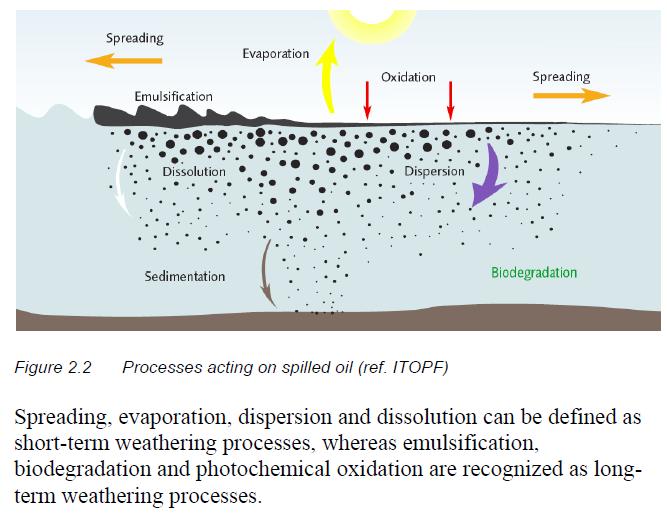
32 Weathering

33 Click image for Hurricane Gustav ADCIRC Animation..
Assessing fate and transport issues of the DWH oil spill using simulations and merged datasets
 Assessing fate and transport issues of the DWH oil spill using simulations and merged datasets Pat Fitzpatrick Geosystems Research Institute Mississippi State University The influence of cyclones on the
Modeling Nearshore Waves for Hurricane Katrina
 Modeling Nearshore Waves for Hurricane Katrina Jane McKee Smith US Army Engineer Research & Development Center Coastal and Hydraulics Laboratory Outline Introduction Modeling Approach Hurricane Katrina
THE IMPORTANCE OF SCIENCE IN COASTAL RESTORATION IN LOUISIANA
 THE IMPORTANCE OF SCIENCE IN COASTAL RESTORATION IN LOUISIANA Barb Kleiss USACE, Mississippi Valley Division August 3, 2011 LCA S&T Office Authorized under WRDA 2007 Designed to address technical issues
Optimal Design of Sediment Diversions for Delta Restoration: lessons learned from examples
 Optimal Design of Sediment Diversions for Delta Restoration: lessons learned from examples Samuel Bentley 1, Angelina Freeman 2, Clinton S. Willson 1, Liviu Giosan 3, Jaye Cable 4 1 LSU 2 EDF 3 WHOI 4
South Florida Coastal Storm Surge and Mapping Study
 South Florida Coastal Storm Surge and Mapping Study Presented by Christopher Bender, Ph.D., P.E., D.CE June 2, 2015 Presentation Overview FEMA risk studies outline Overview South Florida surge study Work
COASTAL DATA APPLICATION
 2015 Coastal GeoTools Proactive By Design. Our Company Commitment COASTAL DATA APPLICATION Projecting Future Coastal Flood Risk for Massachusetts Bay Bin Wang, Tianyi Liu, Daniel Stapleton & Michael Mobile
Advances in Coastal Inundation Simulation Using Unstructured-Grid Coastal Ocean Models
 Advances in Coastal Inundation Simulation Using Unstructured-Grid Coastal Ocean Models Bob Beardsley (WHOI) Changsheng Chen (UMass-Dartmouth) Bob Weisberg (U. South Florida) Joannes Westerink (U. Notre
2013 Louisiana Transportation Conference
 2013 Louisiana Transportation Conference Background FHWA/AASHTO study Objectives of LADOTD study Level III methodology Surge/Wave force methodology 100-Year Surge-Wave GIS Atlas Summary Questions Pensacola,
Wetland attenuation of Hurricane Rita s storm surge
 Wetland attenuation of Hurricane Rita s storm surge Pat Fitzpatrick, Yee Lau, Yongzuo Li, Nam Tran, Chris Hill, and Suzanne Shean Geosystems Research Institute, Mississippi State University Sponsors: NOAA
Effects of input DEM data spatial resolution on Upstream Flood modeling result A case study in Willamette river downtown Portland
 Effects of input DEM data spatial resolution on Upstream Flood modeling result A case study in Willamette river downtown Portland By Hue Duong GEOG 593 Fall 2015 Digital Terrain Analysis Photo: Anh Duc
Estimating Probability of Success Rate
 Estimating Probability of Success Rate Don Ferguson, PhD A member of Appalachian Search and Rescue Conference Objective Provide SAR planners with a tool to help optimize effort allocation based on a number
Amina Rangoonwala and Elijah Ramsey III Wetland and Aquatic Research Center. U.S. Geological Survey. Lafayette, LA
 First I will show examples of radar mapping of hurricane surge extent and duration and optical mapping of the resultant marsh dieback along the Louisiana coast Next we extend these works to hurricane Sandy
What is CERA? Coastal Emergency Risks Assessment
 What is CERA? Coastal Emergency Risks Assessment Visualization tool using OGC standards Displays the outputs from the ADCIRC storm surge model or other coastal models Represents the maps on interactive
Influence of Marsh Restoration and Degradation on Storm Surge and Waves
 Influence of Marsh Restoration and Degradation on Storm Surge and Waves by Ty V. Wamsley, Mary A. Cialone, Joannes Westerink, and Jane M. Smith PURPOSE: The purpose of this CHETN is to examine storm surge
Development, Testing and Application of the Multi-Block LTFATE Hydrodynamic and Sediment Transport Model
 Development, Testing and Application of the Multi-Block LTFATE Hydrodynamic and Sediment Transport Model Earl Hayter Environmental Lab October 25, 2012 LTFATE Multi-Block Hydrodynamic, Water Quality and
Land Area Changes in Coastal Louisiana After Hurricanes Katrina and Rita
 Land Area Changes in Coastal Louisiana After Hurricanes Katrina and Rita By John A. Barras Comparison of classified Landsat Thematic Mapper (TM) satellite imagery acquired before and after the landfalls
Miami-Dade County Technical Update Meeting South Florida Coastal Study. May 11, 2016
 Miami-Dade County Technical Update Meeting South Florida Coastal Study May 11, 2016 Welcome and Introductions FEMA Region IV Christina Lindemer Technical Lead Production and Technical Services (PTS) Contractor
An analysis of storm surge attenuation by wetlands using USGS, FEMA, and NASA data
 An analysis of storm surge attenuation by wetlands using USGS, FEMA, and NASA data Pat Fitzpatrick Geosystems Research Institute Mississippi State University Walter Peterson and Courtney Buckley NASA Marshall
General background on storm surge. Pat Fitzpatrick and Yee Lau Mississippi State University
 General background on storm surge Pat Fitzpatrick and Yee Lau Mississippi State University Storm surge is an abnormal rise of water associated with a cyclone, not including tidal influences Low pressure
Computing the Joint Probability of Hurricane Sandy and Historical Coastal Storm Forcing Parameters from Maine to Virginia
 Computing the Joint Probability of Hurricane Sandy and Historical Coastal Storm Forcing Parameters from Maine to Virginia Chris Massey and Jeff Melby USACE-ERDC Coastal & Hydraulics Lab Chris.Massey@usace.army.mil
Simulation of storm surge and overland flows using geographical information system applications
 Coastal Processes 97 Simulation of storm surge and overland flows using geographical information system applications S. Aliabadi, M. Akbar & R. Patel Northrop Grumman Center for High Performance Computing
Location: Jacksonville, FL December 11, 2012
 Technical Update Meeting Northeast Florida Surge Study Location: Jacksonville, FL December 11, 2012 Agenda 2:00 2:15 Welcome/Introductions Tucker Mahoney, FEMA Region IV Michael DelCharco, BakerAECOM 2:15
An Ensemble based Reliable Storm Surge Forecasting for Gulf of Mexico
 An Ensemble based Reliable Storm Surge Forecasting for Gulf of Mexico Umer Altaf Delft University of Technology, Delft ICES, University of Texas at Austin, USA KAUST, Saudi Arabia JONSMOD 2012, Ifremer,
Hurricane Tracks. Isaac versus previous storms Impacts and solutions. ( Continue by clicking on the slide bar to the right)
") Hurricane Tracks Isaac versus previous storms Impacts and solutions ( Continue by clicking on the slide bar to the right) 1 Hurricane Tracks 2 Sample Hurricanes The sample hurricanes selected were chosen
Hurricane Tracks Isaac versus previous storms Impacts and solutions ( Continue by clicking on the slide bar to the right) 1 Hurricane Tracks 2 Sample Hurricanes The sample hurricanes selected were chosen
Visualizing hurricanes
 Visualizing hurricanes NAME: DATE: Scientific visualization is an integral part of the process of simulating natural phenomena. In the computational sciences, the main goal is to understand the workings
Sea Level Rise and Hurricane Florence storm surge research methodology
 Sea Level Rise and Hurricane Florence storm surge research methodology Hurricane Florence storm surge analysis was conducted using a variety of input sources. In order to determine the maximum storm surge
New developments in data assimilation in MIKE 21/3 FM Assimilation of along-track altimetry data with correlated measurement errors
 New developments in data assimilation in MIKE 21/3 FM Assimilation of along-track altimetry data with correlated measurement errors EnKF Workshop 2016-06-20 Jesper Sandvig Mariegaard Henrik Andersson DHI
WIND EFFECTS ON CHEMICAL SPILL IN ST ANDREW BAY SYSTEM
 WIND EFFECTS ON CHEMICAL SPILL IN ST ANDREW BAY SYSTEM PETER C. CHU, PATRICE PAULY Naval Postgraduate School, Monterey, CA93943 STEVEN D. HAEGER Naval Oceanographic Office, Stennis Space Center MATHEW
Utility of National Spatial Data for Conservation Design Projects
 Utility of National Spatial Data for Conservation Design Projects Steve Williams Biodiversity and Spatial Information Center North Carolina State University PIF CDW St. Louis, MO April 11, 2006 Types of
Robert Weaver, Donald Slinn 1
 1 1 Robert Weaver, Donald Slinn 1 Department of Civil and Coastal Engineering, University of Florida, Gainesville, Florida Supported by the US Office of Naval Research AGU Fall Meeting 2002 Poster OS72A-0342
SUBJECT INDEX. ~ ~5 physico-chemical properties 254,255 Redox potential 254,255
 Aggregates: beds formed by deposition 81,82 breakup by fluid shear, introduction 85,86 deposition from flowing water 80 implications in cohesive sediment transport 102-105 needs for further research 83
USACE-ERDC Coastal Storm Modeling System Updates Chris Massey, PhD
 USACE-ERDC Coastal Storm Modeling System Updates Chris Massey, PhD Research Mathematician USACE-ERDC Coastal & Hydraulics Lab Chris.Massey@usace.army.mil ERDC s Coastal Storm-Modeling System (ERDC CSTORM-MS)
USING MIKE TO MODEL COASTAL CATASTROPHE RISK
 USING MIKE TO MODEL COASTAL CATASTROPHE RISK Nicola Howe, Christopher Thomas, Joss Matthewman, John Maskell* 1 SUMMARY About RMS Who are we and what do we do? How do we use MIKE in our workflow? Case study:
Development of Operational Storm Surge Guidance to Support Total Water Predictions
 Development of Operational Storm Surge Guidance to Support Total Water Predictions J. Feyen 1, S. Vinogradov 1,2, T. Asher 3, J. Halgren 4, Y. Funakoshi 1,5 1. NOAA/NOS//Development Laboratory 2. ERT,
Impacts of Hurricane Rita on the Beaches of Western Louisiana
 Impacts of Hurricane Rita on the Beaches of Western Louisiana By Hilary F. Stockdon, Laura A. Fauver, Asbury H. Sallenger, Jr., and C. Wayne Wright Hurricane Rita made landfall as a category 3 storm in
Forecasting Gulf of Mexico Hypoxia under Scenarios of Watershed and River Management
 Forecasting Gulf of Mexico Hypoxia under Scenarios of Watershed and River Management Dubravko Justic and Lixia Wang Department of Oceanography and Coastal Sciences College of the Coast and Environment
STORM SURGE ATTENUATION IN CHESAPEAKE BAY WETLANDS
 STORM SURGE ATTENUATION IN CHESAPEAKE BAY WETLANDS Seth Lawler, Dr. Celso Ferreira Department of Civil, Environmental and Infrastructure Engineering 1 Background: Surge & Natural Defenses 4 3 1 2 2 Background:
THC-T-2013 Conference & Exhibition
 Modeling of Shutter Coastal Protection against Storm Surge for Galveston Bay C. Vipulanandan, Ph.D., P.E., Y. Jeannot Ahossin Guezo and and B. Basirat Texas Hurricane Center for Innovative Technology (THC-IT)
Simulating Hurricane Storm Surge in the Lower Mississippi River under Varying Flow Conditions
 Simulating Hurricane Storm Surge in the Lower Mississippi River under Varying Flow Conditions R. C. Martyr, M.ASCE 1 ; J. C. Dietrich 2 ; J. J. Westerink, M.ASCE 3 ; P. C. Kerr 4 ; C. Dawson 5 ; J. M.
Reducing Nitrogen Removal Uncertainty for Operation of Mississippi River Sediment Diversions: Nitrate Reduction Rates In Turbulent Flow Conditions
 Reducing Nitrogen Removal Uncertainty for Operation of Mississippi River Sediment Diversions: Nitrate Reduction Rates In Turbulent Flow Conditions Nia R. Hurst, John R. White, Kehui Xu, and MingCheng Ren
Linking Sediment Transport in the Hudson from the Tidal River to the Estuary
 Linking Sediment Transport in the Hudson from the Tidal River to the Estuary Or, what happened to all the mud from Irene? David Ralston, Rocky Geyer, John Warner, Gary Wall Hudson River Foundation seminar
Hurricanes and Storm Surge : Before coming to lab, visit the following web site:
 Geol 108 Lab #7 Week of October 15-19, 2012 Coastal Studies Hurricanes and Storm Surge : Before coming to lab, visit the following web site: http://www.usatoday.com/graphics/weather/gra/gsurge/flash.htm
SLOSH New Orleans Basin 2012 Update
 SLOSH New Orleans Basin 2012 Update Michael Koziara Science and Operations Officer National Weather Service Slidell, LA The Basics What is storm surge? What is SLOSH? Details Assumptions Inundation = Storm
North Wales PRP for Wissahickon Creek Nutrients
 North Wales PRP for Wissahickon Creek Nutrients July 14, 2017 Revised September 7, 2017 Revised August 9, 2018 Prepared for: North Wales Borough 300 School Street North Wales, PA 19454 Corporate Headquarters
Changes in Ecosystems - Natural Events
 Changes in Ecosystems - Natural Events 8A predict and describe how different types of catastrophic events impact ecosystems such as floods, hurricanes, or tornadoes Textbook pages: 396-406 How can ecosystems
Assessing Storm Tide Hazard for the North-West Coast of Australia using an Integrated High-Resolution Model System
 Assessing Storm Tide Hazard for the North-West Coast of Australia using an Integrated High-Resolution Model System J. Churchill, D. Taylor, J. Burston, J. Dent September 14, 2017, Presenter Jim Churchill
Modelling of flow and sediment transport in rivers and freshwater deltas Peggy Zinke
 1 Modelling of flow and sediment transport in rivers and freshwater deltas Peggy Zinke with contributions from Norwegian and international project partners 2 Outline 1. Introduction 2. Basic ideas of flow
The Delaware Environmental Monitoring & Analysis Center
 The Delaware Environmental Monitoring & Analysis Center Tina Callahan Delaware Estuary Science & Environmental Summit 2013 January 27-30, 2013 What is DEMAC? Delaware Environmental Monitoring & Analysis
Forecast of Nearshore Wave Parameters Using MIKE-21 Spectral Wave Model
 Forecast of Nearshore Wave Parameters Using MIKE-21 Spectral Wave Model Felix Jose 1 and Gregory W. Stone 2 1 Coastal Studies Institute, Louisiana State University, Baton Rouge, LA 70803 2 Coastal Studies
Savannah Harbor Expansion Project
 Savannah Harbor Expansion Project Evaluation of Hurricane Surge Impacts with Proposed Mitigation Plan December 2007 Introduction This report summarizes the results of hurricane surge impacts with implementation
Unit 7 Section 3 Computer Lab. Part 1: OPEN OCEAN AND COASTAL IMPACTS OF TROPICAL CYCLONES
 Unit 7 Section 3 Computer Lab Part 1: OPEN OCEAN AND COASTAL IMPACTS OF TROPICAL CYCLONES Educational Outcomes: Tropical cyclones are significant phenomena in the Earth system. They are as much oceanic
Impact of Sea Level Rise on Future Storm-induced Coastal Inundation
 Impact of Sea Level Rise on Future Storm-induced Coastal Inundation Changsheng Chen School for Marine Science and Technology, University of Massachusetts-Dartmouth Email: c1chen@umassd.edu 04/14/2015 Outline
EFFECTIVE TROPICAL CYCLONE WARNING IN BANGLADESH
 Country Report of Bangladesh On EFFECTIVE TROPICAL CYCLONE WARNING IN BANGLADESH Presented At JMA/WMO WORKSHOP ON EFFECTIVE TROPICAL CYCLONE WARNING IN SOUTHEAST ASIA Tokyo, Japan,11-14 March 2014 By Sayeed
Coastal Litigation in the Context of Science Literacy
 Coastal Litigation in the Context of Science Literacy Chris McLindon New Orleans Geological Society February 6, 7 Science Literacy The value of community participation in scientific research is widely
GIS 2010: Coastal Erosion in Mississippi Delta
 1) Introduction Problem overview To what extent do large storm events play in coastal erosion rates, and what is the rate at which coastal erosion is occurring in sediment starved portions of the Mississippi
New Directions in Catastrophe Risk Models
 New Directions in Catastrophe Risk Models World Bank Brown-Bag Lunch Presentation October 9, 2007 Richard J. Murnane Baseline Management Company, Inc. Overview! Background on reinsurance and cat models!
Appendix A STORM SURGE AND WAVE HEIGHT ANALYSIS
 Appendix A STORM SURGE AND WAVE HEIGHT ANALYSIS Memo To: Jeff Robinson, P.E., GEC, Inc. From: Silong Lu, Ph.D., P.E., D.WRE, Dynamic Solutions, LLC. Date: 1/9/2014 CC: Re: Chris Wallen, Vice President,
PRESS RELEASE LOUISIANA UNIVERSITIES MARINE CONSORTIUM July 31, 2011
 PRESS RELEASE LOUISIANA UNIVERSITIES MARINE CONSORTIUM July 31, 2011 Scientists have returned from mapping the 2011 area of hypoxia, commonly known as the Dead Zone, along the Louisiana coast. This year
Monitoring Coastal Marshes for Persistent Saltwater Intrusion
 Monitoring Coastal Marshes for Persistent Saltwater Intrusion Maria Kalcic, 1 Callie Hall, 2 Jeff Russell, 3 and Rose Fletcher 1 1 Science Systems and Applications, Inc., Bldg. 1105, John C. Stennis Space
Modeling the response of a beach restoration project in Louisiana to two consecutive hurricanes
 Louisiana State University LSU Digital Commons LSU Master's Theses Graduate School 2011 Modeling the response of a beach restoration project in Louisiana to two consecutive hurricanes Naveen Khammampati
Lab 12 Coastal Geology
 Lab 12 Coastal Geology I. Fluvial Systems Hydrologic Cycle Runoff that flows into rivers = precipitation (rain and snowmelt) [infiltration (loss to groundwater) + evaporation (loss to atmosphere) + transpiration
ERDC Support for Hurricane Sandy
 ERDC Support for Hurricane Sandy Chris Massey, CHL; Aaron Byrd, CHL; Nawa Pradhan, CHL; Jeff Melby, CHL; Jane Smith, CHL; Robert Walker, ITL; and Jennifer Wozencraft, JALBTCX ERDC Support for Hurricane
Hindcast and validation of Hurricane Ike (2008) waves, forerunner, and storm surge
 waves, forerunner, and storm surge") JOURNAL OF GEOPHYSICAL RESEARCH: OCEANS, VOL. 118, 1 37, doi:10.1002/jgrc.20314, 2013 Hindcast and validation of Hurricane Ike (2008) waves, forerunner, and storm surge M. E. Hope, 1 J. J. Westerink, 1
JOURNAL OF GEOPHYSICAL RESEARCH: OCEANS, VOL. 118, 1 37, doi:10.1002/jgrc.20314, 2013 Hindcast and validation of Hurricane Ike (2008) waves, forerunner, and storm surge M. E. Hope, 1 J. J. Westerink, 1
DEVELOPMENT OF AN INUNDATION FORECAST SYSTEM FOR MASSACHUSETTS COASTAL WATERS
 DEVELOPMENT OF AN INUNDATION FORECAST SYSTEM FOR MASSACHUSETTS COASTAL WATERS C. Chen and R. C. Beardsley MITSG 13-26 Sea Grant College Program Massachusetts Institute of Technology Cambridge, Massachusetts
MODELLING CATASTROPHIC COASTAL FLOOD RISKS AROUND THE WORLD
 MODELLING CATASTROPHIC COASTAL FLOOD RISKS AROUND THE WORLD Nicola Howe Christopher Thomas Copyright 2016 Risk Management Solutions, Inc. All Rights Reserved. June 27, 2016 1 OUTLINE MOTIVATION What we
Dissipation due to Vegetation in Nearshore Wave Models
 Dissipation due to Vegetation in Nearshore Wave Models Jane McKee Smith US Army Engineer Research and Development Center, Coastal and Hydraulic Laboratory Alison Sleath Grzegorzewski, New Orleans District
HURRICANE FRANCES CHARACTERISTICS and STORM TIDE EVALUATION
 HURRICANE FRANCES CHARACTERISTICS and STORM TIDE EVALUATION ((DRAFT)) By Robert Wang and Michael Manausa Sponsored by Florida Department of Environmental Protection, Bureau of Beaches and Coastal Systems
Storm Surge Frequency Analysis using a Modified Joint Probability Method with Optimal Sampling (JPM-OS)
") Storm Surge Frequency Analysis using a Modified Joint Probability Method with Optimal Sampling (JPM-OS) Jay Ratcliff Coastal Hydraulics Lab, of Engineers (USACE) Engineering Research and Development Center
Storm Surge Frequency Analysis using a Modified Joint Probability Method with Optimal Sampling (JPM-OS) Jay Ratcliff Coastal Hydraulics Lab, of Engineers (USACE) Engineering Research and Development Center
Parallel Platform for Multi-Scale CFD Storm Flood Forecast Using Geographical Information System Applications
 Parallel Platform for Multi-Scale CFD Storm Flood Forecast Using Geographical Information System Applications Tian Wan a and Shahrouz Aliabadi a a Northrop Grumman Center for HPC of Ship Systems Engineering,
U.S. Army Corps of Engineers Detroit District. Sediment Trap Assessment Saginaw River, Michigan
 U.S. Army Corps of Engineers Detroit District December 2001 December 2001 This report has been prepared for USACE, Detroit District by: W.F. BAIRD & ASSOCIATES LTD. 2981 YARMOUTH GREENWAY MADISON, WISCONSIN
High Resolution Numerical Models of Tidal Marshes in the Delaware Bay
 High Resolution Numerical Models of Tidal Marshes in the Delaware Bay Ramona Stammermann Dept. of Civil, Architectural & Environmental Engineering, Drexel University, Philadelphia, PA Michael Piasecki
Potential use of the SWOT satellite to characterize the hydrodynamic of the estuaries and coasts
 WOT Potential use of the SWOT satellite to characterize the hydrodynamic of the estuaries and coasts Laignel B. 1, Turki I. 1, Chevalier L. 1, Salameh E. 1,2, Soloy A. 1, Lyard F. 2, Frappart F. 2, Desroches
P1.16 RECENT MONITORING OF SUSPENDED SEDIMENT PATTERNS ALONG LOUISIANA S COASTAL ZONE USING ER-2 BASED MAS DATA AND TERRA BASED MODIS DATA.
 P1.16 RECENT MONITORING OF SUSPENDED SEDIMENT PATTERNS ALONG LOUISIANA S COASTAL ZONE USING ER-2 BASED MAS DATA AND TERRA BASED MODIS DATA. Christopher C. Moeller* 1, M. M. Gunshor 1, W. P. Menzel 2, O.K.
Mapping the River as it Reconnects with Its Delta: Field Studies in Big Mar and Bohemia
 Mapping the River as it Reconnects with Its Delta: Field Studies in Big Mar and Bohemia Ezra Boyd, John Lopez, Andy Baker, Theryn Henkel Lake Pontchartrain Basin Foundation Coastal Sustainability Program
The Northeast Coastal Ocean Forecast System (NECOFS) and Storm Surge and Inundation Prediction. Status and Initial Ideas
 and Storm Surge and Inundation Prediction. Status and Initial Ideas") The Northeast Coastal Ocean Forecast System (NECOFS) and Storm Surge and Inundation Prediction Status and Initial Ideas Changsheng Chen (UMassD) and Bob Beardsley (WHOI) Website: http://fvcom.smast.umassd.edu
The Northeast Coastal Ocean Forecast System (NECOFS) and Storm Surge and Inundation Prediction Status and Initial Ideas Changsheng Chen (UMassD) and Bob Beardsley (WHOI) Website: http://fvcom.smast.umassd.edu
W I N D R E S O U R C E A S S E S S M E N T
 W I N D R E S O U R C E A S S E S S M E N T Annual Energy Production Project: Hundhammer_WS_Express Layout: Layout1 Customer: WindSim 2014-01-29 WindSim AS Fjordgaten 15, N- 3125 Tønsberg, Norway phone.:
Exploitation of Ocean Predictions by the Oil and Gas Industry. GODAE OceanView Symposium 2013
 Exploitation of Ocean Predictions by the Oil and Gas Industry GODAE OceanView Symposium 2013 Introduction Information needs Challenges Acknowledgements IMarEST/SUT Metocean Awareness Course Colleagues
Coastal Emergency Risks Assessment - CERA Real-Time Storm Surge and Wave Visualization Tool
 Coastal Emergency Risks Assessment - CERA Real-Time Storm Surge and Wave Visualization Tool Introduction This document provides guidance for using the Coastal Emergency Risks Assessment (CERA) visualization
Appendix G.19 Hatch Report Pacific NorthWest LNG Lelu Island LNG Maintenance Dredging at the Materials Offloading Facility
 Appendix G.19 Hatch Report Pacific NorthWest LNG Lelu Island LNG Maintenance Dredging at the Materials Offloading Facility Project Memo H345670 To: Capt. David Kyle From: O. Sayao/L. Absalonsen December
Typhoon Maemi and Hurricane Katrina: Impacts and Aftermath. Typhoon Maemi: September 13, Typhoon Maemi Track and Characteristics
 Typhoon Maemi and Hurricane Katrina: Impacts and Aftermath Pierre Julien Un Ji Department of Civil Engineering Colorado State University Fort Collins, Colorado USA September, 2005 Typhoon Maemi: September
Wind Effects on the Choctawhatchee River Plume at Destin Inlet, Florida
 Wind Effects on the Choctawhatchee River Plume at Destin Inlet, Florida Rosemary Cyriac 1, Casey Dietrich 1, Arash Fathi 2, Clint Dawson 2, Kendra Dresback 3, Cheryl Ann Blain 4, Matthew Bilskie 5, Scott
MISSISSIPPI RIVER DELTA OVERVIEW
 MISSISSIPPI RIVER DELTA OVERVIEW Science and Engineering Special Team Conference Louisiana State University October 9, 2012 Introduction Basics of the Mississippi Delta Natural and Human-Induced Land Loss
Ms. A. Mormando's Class *
 8 th Grade Science Essential Standard: 8.E.1.1 Explain the structure of the hydrosphere including: Water distribution on Earth; Local river basin and water availability Stream - A stream is a body of water
Coastal Inundation Risk for SE Florida Incorporating Climate Change Impact on Hurricanes & Sea Level Rise
 Coastal Inundation Risk for SE Florida Incorporating Climate Change Impact on Hurricanes & Sea Level Rise Y. Peter Sheng and V.A. Paramygin Justin R. Davis, Andrew Condon, Andrew Lapetina, Tianyi Liu,
Coastal Storms of the New Jersey Shore
 Coastal Storms of the New Jersey Shore Dr. Steven G. Decker Dept. of Environmental Sciences School of Environmental and Biological Sciences Rutgers University May 25, 2011 Overview Threats Historical Examples
HURRICANE NATE BRIEFING
 HURRICANE NATE BRIEFING 2:00 PM CDT Saturday, October 07, 2017 Prepared by: NWS NWSNewOrleans www.weather.gov/neworleans Situation Overview continues to intensify. It is now forecast to be a category 2
NOAA Storm Surge Modeling Gaps and Priorities
 NOAA Storm Surge Modeling Gaps and Priorities HFIP Meeting November 9 th, 2017 Laura Paulik Alaka NHC Storm Surge Unit Introduction to Probabilistic Storm Surge P-Surge is based on an ensemble of Sea,
Monitoring Hurricane Rita Inland Storm Surge
 Monitoring Hurricane Rita Inland Storm Surge By Benton D. McGee, Roland W. Tollett, and Burl B. Goree Pressure transducers (sensors) are accurate, reliable, and cost-effective tools to measure and record
The Pontchartrain Maurepas Surge Consortium (LPMSC) Lake Sloshing Effect Preliminary Findings
 Lake Sloshing Effect Preliminary Findings") The Pontchartrain Maurepas Surge Consortium (LPMSC) Lake Sloshing Effect Preliminary Findings Lake Pontchartrain Basin Foundation John A. Lopez, Ph.D. with contributions from Dr. Joe Suhayda, Dr. Hal Needham,
The Pontchartrain Maurepas Surge Consortium (LPMSC) Lake Sloshing Effect Preliminary Findings Lake Pontchartrain Basin Foundation John A. Lopez, Ph.D. with contributions from Dr. Joe Suhayda, Dr. Hal Needham,
Eco-hydromorphic Characterization of the Louisiana Coastal Region Using Multiple Remotely Sensed Data Sources and Analyses
 National Wetlands Research Center Eco-hydromorphic Characterization of the Louisiana Coastal Region Using Multiple Remotely Sensed Data Sources and Analyses 1Holly Beck, 2 Brady Couvillion, 1 Nadine Trahan
Hurricane KATRINA Lessons Learned for Managing Risk
 Hurricane KATRINA Lessons Learned for Managing Risk Steven L. Stockton, P.E. Deputy Director of Civil Works U.S. Army Corps of Engineers What Happened? Storm Path from August 23 to 31, 2005 Mon. August
Navigating the Hurricane Highway Understanding Hurricanes With Google Earth
 Navigating the Hurricane Highway Understanding Hurricanes With Google Earth 2008 Amato Evan, Kelda Hutson, Steve Kluge, Lindsey Kropuenke, Margaret Mooney, and Joe Turk Images and data courtesy hurricanetracking.com,
MISSISSIPPI COASTAL IMPROVEMENTS
 MISSISSIPPI COASTAL IMPROVEMENTS PROGRAM (MsCIP) Comprehensive Barrier 237 27 200 237 27 200 Island 237 Restoration 27 200 Plan 80 9 27 252 74.59 255 255 255 0 0 0 63 63 63 3 32 22 239 65 53 0 35 20 2
The Mississippi River: Its Role in Restoration Efforts and Potential Effects of Climate Change
 The Mississippi River: Its Role in Restoration Efforts and Potential Effects of Climate Change Clinton S. Willson, P.E., Ph.D. Department of Civil & Environmental Engineering Louisiana State University
Appendix G.18 Hatch Report Pacific NorthWest LNG Lelu Island LNG Potential Impacts of the Marine Structures on the Hydrodynamics and Sedimentation
 Appendix G.18 Hatch Report Pacific NorthWest LNG Lelu Island LNG Potential Impacts of the Marine Structures on the Hydrodynamics and Sedimentation Patterns Project Memo H345670 To: Capt. David Kyle From:
HURRICANE ISAAC WITH AND WITHOUT YEAR HSDRRS EVALUATION
 HURRICANE ISAAC WITH AND WITHOUT 2012 100-YEAR HSDRRS EVALUATION FINAL REPORT FEBRUARY 2013 Executive Summary EXECUTIVE SUMMARY SIGNIFICANT FINDINGS According to the Saffir-Simpson Hurricane Wind Scale,
ΛTKINS. Applications of Regional Sediment Management Concepts in Texas Estuarine Restoration Projects. Riparian Workshop Fort Worth, October 17, 2012
 Juan C Moya, PhD., PG Coastal Planning and Restoration Applications of Regional Sediment Management Concepts in Texas Estuarine Restoration Projects Riparian Workshop Fort Worth, October 17, 2012 West
Modeling Salinity Distribution in Apalachicola Bay, Florida
 Modeling Salinity Distribution in Apalachicola Bay, Florida Factors Affecting Salinity Distribution in Apalachicola Bay: Freshwater Inflow Apalachicola River Lake Lanier Precipitation Wind Hurricane Climate
Performance of the Unstructured-Mesh, SWAN+ ADCIRC Model in Computing Hurricane Waves and Surge
 DOI 10.1007/s10915-011-9555-6 Performance of the Unstructured-Mesh, SWAN+ ADCIRC Model in Computing Hurricane Waves and Surge J.C. Dietrich S. Tanaka J.J. Westerink C.N. Dawson R.A. Luettich Jr. M. Zijlema