Advances in Coastal Inundation Simulation Using Unstructured-Grid Coastal Ocean Models
|
|
|
- Emily Wood
- 5 years ago
- Views:
Transcription
1 Advances in Coastal Inundation Simulation Using Unstructured-Grid Coastal Ocean Models Bob Beardsley (WHOI) Changsheng Chen (UMass-Dartmouth) Bob Weisberg (U. South Florida) Joannes Westerink (U. Notre Dame) MARICOOS Coastal Inundation Module Design Workshop September 14-15, 2006
2 Basic Requirements for Inundation Simulation (coastal flooding caused by river discharge, tides, storm surge, and tsunami processes) 1) A high-resolution, physics-based circulation model with flooding and drying capabilities. 2) A high-resolution water depth (bathymetry) and land elevation data set on which to overlay the model. 3) Accurate enough river discharge, tidal forcing, and surface wind and pressure fields to drive the model.
 coastal ocean model (J. Westerink, R. Luettich, et al, 1992) 2. Finite-Volume Coastal Ocean Model (FVCOM) (C. Chen, H. Liu, and R Beardsley, 2003)")
3 Basic Classes of Ocean Model Grids: 1. Structured cartesian (rectangular), orthogonal curvilinear, spherical 2. Unstructured triangular, trapezoidal (geometric flexibility) Two U.S. Unstructured-Grid Ocean Models: 1. ADCIRC (finite-element) coastal ocean model (J. Westerink, R. Luettich, et al, 1992) 2. Finite-Volume Coastal Ocean Model (FVCOM) (C. Chen, H. Liu, and R Beardsley, 2003)

4 Example of ADCIRC applied to Hurricane Surge Simulation Westerink, et al, A Basin to Channel Scale Unstructured Grid Hurricane Storm Surge Model Applied to Southern Louisiana, Monthly Weather Review (in review)

5 Land BC s: 1. Upriver Tidal Propagation 2. River Discharge OBC s: 1. Tides 2. Inverted Barometer Surface Forcing: 1. Wind Stress 2. Atmospheric Pressure (Large domain approach simplifies boundary conditions, avoids tidal resonance problems in GoM, at the cost of ~ 5-10% additional grid cells/computational effort)
6

7

8 Hurricane Betsy track and 10 minute averaged maximum marine wind speed contours from H*WIND (m/s)

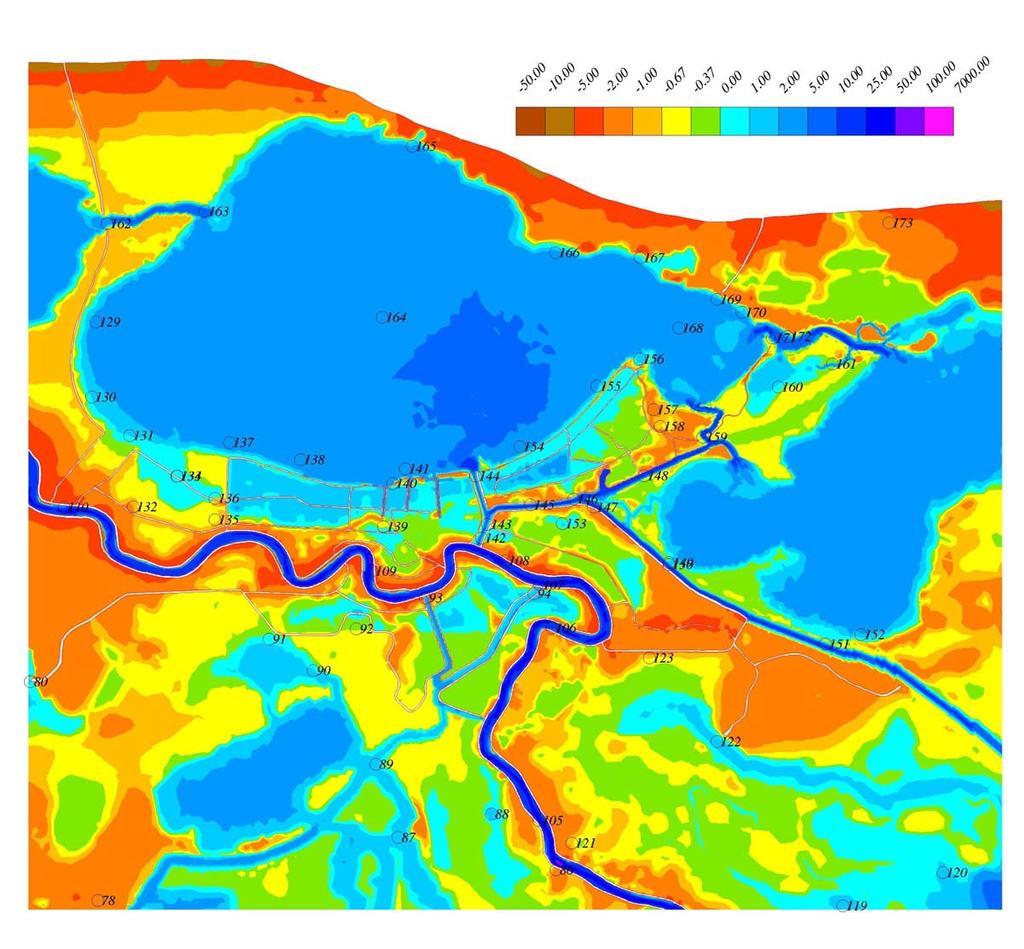
9 Hurricane Betsy modeled peak storm surge elevation, with error in peak storm surge height (m) at stations. Positive error values indicate model over-prediction and negative values indicate under-prediction. Dry areas are shown in gray and levee structures are shown as brown lines.
10
11 Steps taken to obtain accurate model simulation 1. Very careful adjustment of bathymetry and elevation data from different sources to common surface (steric effects). 2. Different methods used for flooding and drying of grid cells, barriers (impervious and porous), spillways. 3. Used two hurricane models to produce surface wind and pressure fields to drive model. 4. Modification of wind field over land and in land-water zone due to spatial change in surface roughness (z o ) caused by land canopy, buildings, etc. 5. Adjusted grid resolution, bathymetry/topography detail as suggested by model results and model/data comparisons. 6. Wind-wave effects on ocean roughness z o, surge elevation, and sediment/structure change TO BE ADDED.
12 FVCOM: Finite-Volume Coastal Ocean Model Key Features: An unstructured triangle grid for representing complex coastal geometry 3D primitive equations, with flow dependent turbulence closure Finite-volume (differences of fluxes) for mass, momentum, heat, and salt conservation, plus computational efficiency Provision for flooding and drying land Examples: 1. Hurricane surge simulation 2. NE regional model system for inundation simulation

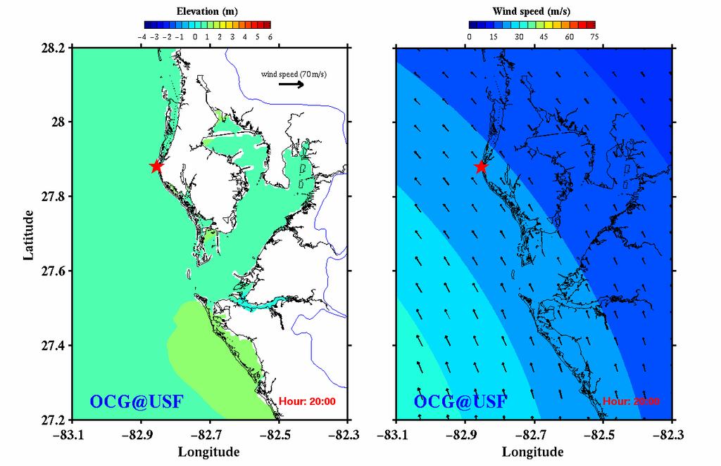
13 Example of FVCOM applied to Hurricane Surge Simulation Weisberg and Zheng, What May Have Occurred Had Hurricane Ivan Made Landfall Within the Tampa Bay Region?

14 A Zoom View of the Tampa Bay Region Longitude

15 Merged Bathymetry and Topography
16
17 Schematic of UMassD Regional NE Model System for Inundation Simulation/Prediction BC s NCEP North American Weather Model (NAM) Satellite SST Buoy Winds Insolation Regional Mesoscale Model (MM5,WRF) Global Wave Model BC s BC s Ocean GCM Heat Flux Wind Stress P-E U,V Form Drag Surface Wave Model SWAN U,V, Waves, Langmuir Cells Global Tidal Model Freshwater Input Local Inundation Models (FVCOM, ADCIRC,...) FVCOM Bottom Stress Satellite SST, U,V Buoy T,S,U,V,P BC s Sediment Transport Model (USGS) KEY In Development Existing Models Core Models Data
 Assimilation")

18 The Gulf of Maine/Georges Bank MM5 Weather Forecast Model System Song Hu and Zhongxiang Wu ETA/NAM Nested Region domain MM5 (resolution: 30 km) Non-hydrostatic Assimilation Air stations Buoy data Satellite data Local network Local domain Nested Local domain MM5 (resolution: 10 km) Assimilation SST (9 km) Local buoys Sites of Surface Buoys Regional domain Wind stress, heat flux, air pressure, precipitation - evaporation On-going modifications: 1. Convert the MM5 to 4 km resolution over the Gulf of Maine and 1 km resolution over Georges Bank, Mass Bay and New England Shelf 2. Convert to WRF mesoscale model

19
 256 Gigabytes RAM,")

20 256 Processors (Intel 3.4 GHz Pentium 4) 256 Gigabytes RAM, Infiniband High Speed Network 7 Terabytes disk space Third Generation Gulf of Maine FVCOM


21

22

23 M2 tidal currents
24 Summary ADCIRC and FVCOM both use unstructured triangular grids to represent complex coastal geometries - allowing river to basin grids with sufficient horizontal resolution to capture key physical processes ADCIRC and FVCOM both feature flooding and drying - allowing them to simulate inundation associated with river, tidal, storm surge, and tsunami processes FVCOM uses finite-volume approach providing excellent local mass, momentum, heat, salt conservation FVCOM is an open community model system with support by a UMassD/WHOI development team lead by C. Chen, G. Cowles, and R. Beardsley. UMassD NE regional coupled atmosphere/ocean FVCOM system exists - which could provide starting point for regional inundation prediction system.
The Northeast Coastal Ocean Forecast System (NECOFS) and Storm Surge and Inundation Prediction. Status and Initial Ideas
 and Storm Surge and Inundation Prediction. Status and Initial Ideas") The Northeast Coastal Ocean Forecast System (NECOFS) and Storm Surge and Inundation Prediction Status and Initial Ideas Changsheng Chen (UMassD) and Bob Beardsley (WHOI) Website: http://fvcom.smast.umassd.edu
The Northeast Coastal Ocean Forecast System (NECOFS) and Storm Surge and Inundation Prediction Status and Initial Ideas Changsheng Chen (UMassD) and Bob Beardsley (WHOI) Website: http://fvcom.smast.umassd.edu
An Unstructured Grid, Finite-Volume Coastal Ocean Model (FVCOM), Validations and Applications
, Validations and Applications") An Unstructured Grid, Finite-Volume Coastal Ocean Model (FVCOM), Validations and Applications Bob Beardsley, Changsheng Chen, and Geoff Cowles http://fvcom.smast.umassd.edu Data Assimilation in Support
An Unstructured Grid, Finite-Volume Coastal Ocean Model (FVCOM), Validations and Applications Bob Beardsley, Changsheng Chen, and Geoff Cowles http://fvcom.smast.umassd.edu Data Assimilation in Support
Topics 1. IOOS on the US East Coast. 2. Regional Physical & Ecosystem Modeling Efforts
 Topics 1. IOOS on the US East Coast National Federation of Regional Associations http://usnfra.org - NERACOOS - MACOORA 2. Regional Physical & Ecosystem Modeling Efforts Northeast Regional Association
Critical Issues in Assessment of Offshore Wind Farm Development on Dispersion and Settling of Scallop Larvae in the Northeast U.S.
 Critical Issues in Assessment of Offshore Wind Farm Development on Dispersion and Settling of Scallop Larvae in the Northeast U.S. Coastal Ocean Changsheng Chen School for Marine Science and Technology
Impact of Sea Level Rise on Future Storm-induced Coastal Inundation
 Impact of Sea Level Rise on Future Storm-induced Coastal Inundation Changsheng Chen School for Marine Science and Technology, University of Massachusetts-Dartmouth Email: c1chen@umassd.edu 04/14/2015 Outline
DEVELOPMENT OF AN INUNDATION FORECAST SYSTEM FOR MASSACHUSETTS COASTAL WATERS
 DEVELOPMENT OF AN INUNDATION FORECAST SYSTEM FOR MASSACHUSETTS COASTAL WATERS C. Chen and R. C. Beardsley MITSG 13-26 Sea Grant College Program Massachusetts Institute of Technology Cambridge, Massachusetts
NORTHEAST COASTAL OCEAN FORECAST SYSTEM (NECOFS)
") NORTHEAST COASTAL OCEAN FORECAST SYSTEM (NECOFS) R. C. Beardsley and C. Chen MITSG 13-27 Sea Grant College Program Massachusetts Institute of Technology Cambridge, Massachusetts 02139 NOAA Grant No. NA10OAR4170086
NORTHEAST COASTAL OCEAN FORECAST SYSTEM (NECOFS) R. C. Beardsley and C. Chen MITSG 13-27 Sea Grant College Program Massachusetts Institute of Technology Cambridge, Massachusetts 02139 NOAA Grant No. NA10OAR4170086
Coastal Cities-Coastal Impacts: 'The Tides They Are A-Changin
 Coastal Cities-Coastal Impacts: 'The Tides They Are A-Changin Susan K. Avery Woods Hole Oceanographic Institution Thanks to: Jeff Donnelly, Chris Reddy, Porter Hoagland, Jim Price, Dennis McGillicuddy,
Coupled, Unstructured Grid, Wave and Circulation Models: Validation and Resolution Requirements
 Coupled, Unstructured Grid, Wave and Circulation Models: Validation and Resolution Requirements J.C. Dietrich, J.J. Westerink University of Notre Dame C. Dawson University of Texas at Austin M. Zijlema,
Modeling Nearshore Waves for Hurricane Katrina
 Modeling Nearshore Waves for Hurricane Katrina Jane McKee Smith US Army Engineer Research & Development Center Coastal and Hydraulics Laboratory Outline Introduction Modeling Approach Hurricane Katrina
Robert Weaver, Donald Slinn 1
 1 1 Robert Weaver, Donald Slinn 1 Department of Civil and Coastal Engineering, University of Florida, Gainesville, Florida Supported by the US Office of Naval Research AGU Fall Meeting 2002 Poster OS72A-0342
THC-T-2013 Conference & Exhibition
 Modeling of Shutter Coastal Protection against Storm Surge for Galveston Bay C. Vipulanandan, Ph.D., P.E., Y. Jeannot Ahossin Guezo and and B. Basirat Texas Hurricane Center for Innovative Technology (THC-IT)
Simulation of storm surge and overland flows using geographical information system applications
 Coastal Processes 97 Simulation of storm surge and overland flows using geographical information system applications S. Aliabadi, M. Akbar & R. Patel Northrop Grumman Center for High Performance Computing
Flood and Sea Level Rise Mapping Methodologies: The Way Forward
 Flood and Sea Level Rise Mapping Methodologies: The Way Forward Malcolm L. Spaulding Professor Emeritus, Ocean Engineering University of Rhode Island spaulding@egr.uri.edu Interagency Coordination Meeting
Benchmarking of Hydrodynamic Models for Development of a Coupled Storm Surge Hazard-Infrastructure Modeling Method to improve Inundation Forecasting
 Benchmarking of Hydrodynamic Models for Development of a Coupled Storm Surge Hazard-Infrastructure Modeling Method to improve Inundation Forecasting Abstract Fragility-based models currently used in coastal
Tampa Bay Storm Surge & Wave Vulnerability, Response to Hurricane Irma and Tools for Future Use
 Tampa Bay Storm Surge & Wave Vulnerability, Response to Hurricane Irma and Tools for Future Use Robert H. Weisberg with J. Chen, Y. Liu and L. Zheng College of Marine Science University of South Florida
West Florida Shelf and Tampa Bay Responses to Hurricane Irma: What Happened and Why
 West Florida Shelf and Tampa Bay Responses to Hurricane Irma: What Happened and Why R.H. Weisberg Y. Liu J. Chen College of Marine Science University of South Florida St. Petersburg, FL SECOORA Webinar
J-Rapid PI: Jun Sasaki 1 T. Suzuki 1 and R. U. A. Wiyono 1. Rapid PI: Changsheng Chen 2 C. Beardsley 3, Z. Lai 2, R., H. Lin 2, J. Lin 3 and R.
 Collaborative Research: The Japan March 11 Earthquake: Tsunami inundation, and initial spread of Fukushima Dai-ichi Radionuclides into the Pacific Ocean: Model Assessment J-Rapid PI: Jun Sasaki 1 T. Suzuki
Saiful Islam Anisul Haque
 Workshop on Disaster Prevention/Mitigation Measures against Floods and Storm Surges in Bangladesh on 17-21 November, 2012, in Kyoto University, Japan Component 2: Flood disaster risk assessment and mitigation
An Investigation of the Influence of Waves on Sediment Processes in Skagit Bay
 DISTRIBUTION STATEMENT A. Approved for public release; distribution is unlimited. An Investigation of the Influence of Waves on Sediment Processes in Skagit Bay Geoffrey W. Cowles School for Marine Science
An Integrated Storm Surge, Hurricane Wave, Salinity and Sediment Transport Modeling System for Breton Sound, LA
 An Integrated Storm Surge, Hurricane Wave, Salinity and Sediment Transport Modeling System for Breton Sound, LA Q. Jim Chen Department of Civil and Environmental Engineering qchen@lsu.edu Acknowledgements
Research of the Influential Factors on the Simulation of Storm Surge in the Bohai Sea
 Send Orders for Reprints to reprints@benthamscience.net The Open Mechanical Engineering Journal, 2014, 8, 151-156 151 Open Access Research of the Influential Factors on the Simulation of Storm Surge in
An Ensemble based Reliable Storm Surge Forecasting for Gulf of Mexico
 An Ensemble based Reliable Storm Surge Forecasting for Gulf of Mexico Umer Altaf Delft University of Technology, Delft ICES, University of Texas at Austin, USA KAUST, Saudi Arabia JONSMOD 2012, Ifremer,
A SIMULATION OF THE HURRICANE CHARLEY STORM SURGE AND ITS BREACH OF NORTH CAPTIVA ISLAND
 A SIMULATION OF THE HURRICANE CHARLEY STORM SURGE AND ITS BREACH OF NORTH CAPTIVA ISLAND R. H. WEISBERG (1) AND L. ZHENG (1) (1) College of Marine Science, University of South Florida St. Petersburg, FL
Earth Observation in coastal zone MetOcean design criteria
 ESA Oil & Gas Workshop 2010 Earth Observation in coastal zone MetOcean design criteria Cees de Valk BMT ARGOSS Wind, wave and current design criteria geophysical process uncertainty modelling assumptions
Casco Bay Estuary Partnership (CBEP) USM Muskie School 34 Bedford St 228B. Portland, ME
 USM Muskie School 34 Bedford St 228B. Portland, ME") Casco Bay Estuary Partnership (CBEP) USM Muskie School 34 Bedford St 228B Wishcamper Center Portland, ME 04104 9300 Malcolm L. Spaulding Applied Science Associates 55 Village Square Drive South Kingstown,
Casco Bay Estuary Partnership (CBEP) USM Muskie School 34 Bedford St 228B Wishcamper Center Portland, ME 04104 9300 Malcolm L. Spaulding Applied Science Associates 55 Village Square Drive South Kingstown,
Implications from the comparisons between two- and threedimensional model simulations of the Hurricane Ike storm surge
 JOURNAL OF GEOPHYSICAL RESEARCH: OCEANS, VOL. 118, 3350 3369, doi:10.1002/jgrc.20248, 2013 Implications from the comparisons between two- and threedimensional model simulations of the Hurricane Ike storm
HFIP- Supported Improvements to Storm Surge Forecas6ng in 2012
 HFIP- Supported Improvements to Storm Surge Forecas6ng in 2012 Jesse C. Feyen (NOS/OCS), Jamie Rhome (NWS/NHC), Rick LueJch (UNC- CH), Jason Fleming (Seahorse Consul6ng), Brian Blanton (RENCI), Yuji Funakoshi
Applying Gerris to Mixing and Sedimentation in Estuaries
 Applying Gerris to Mixing and Sedimentation in Estuaries Timothy R. Keen U.S. Naval Research Laboratory Stennis Space Center, Mississippi, U.S.A. 4 July 2011 Université Pierre et Marie Curie Paris, France
HURRICANE - GENERATED OCEAN WAVES
 HURRICANE - GENERATED OCEAN WAVES Fumin Xu,, Will Perrie Bechara Toulany and Peter C Smith Fisheries and Oceans Canada, Bedford Institute of Oceanography, Dartmouth, NS, Canada College of Ocean Engineering,
Development of a coastal modeling system
 Development of a coastal modeling system John Warner US Geological Survey Coastal and Marine Geology Program Woods Hole, MA U.S. Department of the Interior U.S. Geological Survey Jeff List Rob Thieler
Experimental storm surge forecasting in the Bay of Bengal
 Environmental Problems in Coastal Regions VI 397 Experimental storm surge forecasting in the Bay of Bengal H. S. Mashriqui 1, G. P. Kemp 1, I. van Heerden 1, J. Westerink 2, Y. S. Yang 1 & B. D. Ropers-Huilman
Coupled Wind, Wave, and Surge Modeling. Pat Welsh University of North Florida 10th International Wave Conference 12 November 2007
 Coupled Wind, Wave, and Surge Modeling Pat Welsh University of North Florida 10th International Wave Conference 12 November 2007 Current AWIS Lab Project & Proposals Collaborators Our Lab is too small
USING MIKE TO MODEL COASTAL CATASTROPHE RISK
 USING MIKE TO MODEL COASTAL CATASTROPHE RISK Nicola Howe, Christopher Thomas, Joss Matthewman, John Maskell* 1 SUMMARY About RMS Who are we and what do we do? How do we use MIKE in our workflow? Case study:
Operational Estuarine & Coastal Forecast Systems in NOAA s. National Ocean Service
 Operational Estuarine & Coastal Forecast Systems in NOAA s. National Ocean Service Eugene Wei, Frank Aikman III and Richard Patchen NOAA S S National Ocean Service Workshop on: Data Assimilation in Support
COASTAL DATA APPLICATION
 2015 Coastal GeoTools Proactive By Design. Our Company Commitment COASTAL DATA APPLICATION Projecting Future Coastal Flood Risk for Massachusetts Bay Bin Wang, Tianyi Liu, Daniel Stapleton & Michael Mobile
Coupling of Wave and Hydrodynamic Models for Predicting Coastal Inundation: A case study in Jakarta and Semarang
 Coupling of Wave and Hydrodynamic Models for Predicting Coastal Inundation: A case study in Jakarta and Semarang http://peta-maritim.bmkg.go.id/cifdp/maps Nelly Florida Riama,Andri Ramdhani, Andi Eka Sakya,,
Adapting NEMO for use as the UK operational storm surge forecasting model
 Adapting NEMO for use as the UK operational storm surge forecasting model Rachel Furner 1, Jane Williams 2, Kevin Horsburgh 2, Andy Saulter 1 1; Met Office 2; NOC Table of Contents Existing CS3 model Developments
Coastal Emergency Risks Assessment - CERA Real-Time Storm Surge and Wave Visualization Tool
 Coastal Emergency Risks Assessment - CERA Real-Time Storm Surge and Wave Visualization Tool Introduction This document provides guidance for using the Coastal Emergency Risks Assessment (CERA) visualization
Agenda FVCOM Users Workshop Bedford Institute of Oceanography, Dartmouth October 20-22, Oral Program. Day 1: October 20
 Agenda FVCOM Users Workshop Bedford Institute of Oceanography, Dartmouth October 20-22, 2015 Oral Program 8:30 Registration Day 1: October 20 9:00 Welcome S. Haigh/D. Greenberg Session 1 C. Chen 9:10 A
Signals of sea-level rise in Delaware and Chesapeake Bay tides
 Signals of sea-level rise in Delaware and Chesapeake Bay tides Andrew C. Ross and Raymond G. Najjar Pennsylvania State University Also thanks to Ming Li, Serena Lee, Fan Zhang, Wei Liu Observations show
Moving Freshwater to the Ocean: Hydrology-Ocean Model Coupling
 Moving Freshwater to the Ocean: Hydrology-Ocean Model Coupling Cheryl Ann Blain 1, Tim Campbell 1, Song Yang 2, Aubrey Dugger 3, Paul Martin 1, Tommy Jenson 1 Naval Research Laboratory 1 Oceanography Division,
M. Liste 1, M. Grifoll 2, I. Keupers 1, J. Fernández 3, H. Ortega 1, J. Monbaliu 1
 M. Liste 1, M. Grifoll 2, I. Keupers 1, J. Fernández 3, H. Ortega 1, J. Monbaliu 1 1 Hydraulics Laboratory (K.U.Leuven, Belgium) 2 Laboratori d Enginyeria Marítima (LIM/UPC, Spain) 3 SIMO, Spain. Motivation
Discussion of forcing errors in the Bay and how to deal with these using the LETKF. Assimilation with synthetic obs with realistic coverage
 Discussion of forcing errors in the Bay and how to deal with these using the LETKF Assimilation with synthetic obs with realistic coverage Ecologically and economically important resource Home to over
Development of Operational Storm Surge Guidance to Support Total Water Predictions
 Development of Operational Storm Surge Guidance to Support Total Water Predictions J. Feyen 1, S. Vinogradov 1,2, T. Asher 3, J. Halgren 4, Y. Funakoshi 1,5 1. NOAA/NOS//Development Laboratory 2. ERT,
*Corresponding author
 8/27/2004 10:04 AM A New Generation Hurricane Storm Surge Model for Southern Louisiana Joannes J. Westerink 1*, Jesse C. Feyen 1, John H. Atkinson 2, Richard A. Luettich 3, Clint N. Dawson 4, Mark D. Powell
A Strategy for the Development of Coupled Ocean- Atmosphere Discontinuous Galerkin Models
 A Strategy for the Development of Coupled Ocean- Atmosphere Discontinuous Galerkin Models Frank Giraldo Department of Applied Math, Naval Postgraduate School, Monterey CA 93943 Collaborators: Jim Kelly
POLCOMS Metadata for the ARCoES project Keywords: POLCOMS, WAM, residual circulation, waves, Liverpool Bay, UK shelf
 POLCOMS Metadata for the ARCoES project Keywords: POLCOMS, WAM, residual circulation, waves, Liverpool Bay, UK shelf POLCOMS is the Proudman Oceanographic Laboratory Coastal Ocean Modelling System. It
Lecture-1: FVCOM-An unstructured grid Finite-Volume Community Ocean Model
 Lecture-1: FVCOM-An unstructured grid Finite-Volume Community Ocean Model Changsheng Chen School for Marine Science and Technology University of Massachusetts-Dartmouth New Bedford, MA 02744 Email: c1chen@umassd.edu,
HYCOM in the South Atlantic Bight: Performance and Client Applications
 HYCOM in the South Atlantic Bight: Performance and Client Applications Brian Blanton, Alfredo Aretxabaleta Department of Marine Sciences UNC-Chapel Hill UNC Group Activities HYCOM/GODAE NOPP Provide SEACOOS
Coastal Inundation Risk for SE Florida Incorporating Climate Change Impact on Hurricanes & Sea Level Rise
 Coastal Inundation Risk for SE Florida Incorporating Climate Change Impact on Hurricanes & Sea Level Rise Y. Peter Sheng and V.A. Paramygin Justin R. Davis, Andrew Condon, Andrew Lapetina, Tianyi Liu,
Storm Surge Frequency Analysis using a Modified Joint Probability Method with Optimal Sampling (JPM-OS)
") Storm Surge Frequency Analysis using a Modified Joint Probability Method with Optimal Sampling (JPM-OS) Jay Ratcliff Coastal Hydraulics Lab, of Engineers (USACE) Engineering Research and Development Center
Storm Surge Frequency Analysis using a Modified Joint Probability Method with Optimal Sampling (JPM-OS) Jay Ratcliff Coastal Hydraulics Lab, of Engineers (USACE) Engineering Research and Development Center
Forecast of Nearshore Wave Parameters Using MIKE-21 Spectral Wave Model
 Forecast of Nearshore Wave Parameters Using MIKE-21 Spectral Wave Model Felix Jose 1 and Gregory W. Stone 2 1 Coastal Studies Institute, Louisiana State University, Baton Rouge, LA 70803 2 Coastal Studies
Tidal Constituents in the Persian Gulf, Gulf of Oman and Arabian Sea: a Numerical Study
 Indian Journal of Geo-Marine Sciences Vol. 45(8), August 2016, pp. 1010-1016 Tidal Constituents in the Persian Gulf, Gulf of Oman and Arabian Sea: a Numerical Study P. Akbari 1 *, M. Sadrinasab 2, V. Chegini
CERA-Atlantic Storm Surge Web Page: Improvements for 2013 Based on EM Feedback
 CERA-Atlantic Storm Surge Web Page: Improvements for 2013 Based on EM Feedback Jessica Losego Meteorologist University of North Carolina - Institute for the Environment Rick Luettich Director, UNC IMS
What is CERA? Coastal Emergency Risks Assessment
 What is CERA? Coastal Emergency Risks Assessment Visualization tool using OGC standards Displays the outputs from the ADCIRC storm surge model or other coastal models Represents the maps on interactive
Recent Developments in the Navy Coastal Ocean Model and its application as the ocean component in regional coupled forecast models
 Recent Developments in the Navy Coastal Ocean Model and its application as the ocean component in regional coupled forecast models Tommy Jensen, Paul Martin, Clark Rowley, Tim Campbell, Richard Allard,
THE IMPORTANCE OF SCIENCE IN COASTAL RESTORATION IN LOUISIANA
 THE IMPORTANCE OF SCIENCE IN COASTAL RESTORATION IN LOUISIANA Barb Kleiss USACE, Mississippi Valley Division August 3, 2011 LCA S&T Office Authorized under WRDA 2007 Designed to address technical issues
Comparative Analysis of Hurricane Vulnerability in New Orleans and Baton Rouge. Dr. Marc Levitan LSU Hurricane Center. April 2003
 Comparative Analysis of Hurricane Vulnerability in New Orleans and Baton Rouge Dr. Marc Levitan LSU Hurricane Center April 2003 In order to compare hurricane vulnerability of facilities located in different
Parallel Platform for Multi-Scale CFD Storm Flood Forecast Using Geographical Information System Applications
 Parallel Platform for Multi-Scale CFD Storm Flood Forecast Using Geographical Information System Applications Tian Wan a and Shahrouz Aliabadi a a Northrop Grumman Center for HPC of Ship Systems Engineering,
Impact of Changes in Morphology on Extent and Duration of Inundation during Tropical Cyclones
 DISTRIBUTION STATEMENT A. Approved for public release; distribution is unlimited. Impact of Changes in Morphology on Extent and Duration of Inundation during Tropical Cyclones Jayaram Veeramony Code 7322,
An analysis of storm surge attenuation by wetlands using USGS, FEMA, and NASA data
 An analysis of storm surge attenuation by wetlands using USGS, FEMA, and NASA data Pat Fitzpatrick Geosystems Research Institute Mississippi State University Walter Peterson and Courtney Buckley NASA Marshall
Influence of Marsh Restoration and Degradation on Storm Surge and Waves
 Influence of Marsh Restoration and Degradation on Storm Surge and Waves by Ty V. Wamsley, Mary A. Cialone, Joannes Westerink, and Jane M. Smith PURPOSE: The purpose of this CHETN is to examine storm surge
5. General Circulation Models
 5. General Circulation Models I. 3-D Climate Models (General Circulation Models) To include the full three-dimensional aspect of climate, including the calculation of the dynamical transports, requires
SLOSH New Orleans Basin 2012 Update
 SLOSH New Orleans Basin 2012 Update Michael Koziara Science and Operations Officer National Weather Service Slidell, LA The Basics What is storm surge? What is SLOSH? Details Assumptions Inundation = Storm
Assimilation Impact of Physical Data on the California Coastal Ocean Circulation and Biogeochemistry
 Assimilation Impact of Physical Data on the California Coastal Ocean Circulation and Biogeochemistry Yi Chao, Remote Sensing Solutions (RSS)/UCLA; John D. Farrara, RSS; Fei Chai, University of Maine; Hongchun
A Dissertation. Presented to. The Faculty of the School of Marine Science. The College of William and Mary in Virginia. In Partial Fulfillment
 Developing an Unstructured Grid, Coupled Storm Surge, Wind Wave and Inundation Model for Super-regional Applications A Dissertation Presented to The Faculty of the School of Marine Science The College
On the importance of the forward speed of hurricanes in storm surge forecasting: A numerical study
 Click Here for Full Article GEOPHYSICAL RESEARCH LETTERS, VOL. 36, L07609, doi:10.1029/2008gl036953, 2009 On the importance of the forward speed of hurricanes in storm surge forecasting: A numerical study
Performance of the Unstructured-Mesh, SWAN+ ADCIRC Model in Computing Hurricane Waves and Surge
 DOI 10.1007/s10915-011-9555-6 Performance of the Unstructured-Mesh, SWAN+ ADCIRC Model in Computing Hurricane Waves and Surge J.C. Dietrich S. Tanaka J.J. Westerink C.N. Dawson R.A. Luettich Jr. M. Zijlema
Yi Chao Jet Propulsion Laboratory California Institute of Technology & Joint Institute for Regional Earth System Science and Engineering (JIFRESSE)
") Strategy to Develop a 3D Ocean Circulation Forecasting System for Cook Inlet Yi Chao Jet Propulsion Laboratory California Institute of Technology & Joint Institute for Regional Earth System Science and
Strategy to Develop a 3D Ocean Circulation Forecasting System for Cook Inlet Yi Chao Jet Propulsion Laboratory California Institute of Technology & Joint Institute for Regional Earth System Science and
A Modeling Study on Flows in the Strait of Hormuz (SOH)
") A Modeling Study on Flows in the Strait of Hormuz (SOH) Peter C Chu & Travis Clem Naval Postgraduate School Monterey, CA 93943, USA IUGG 2007: PS005 Flows and Waves in Straits. July 5-6, Perugia, Italy
A Modeling Study on Flows in the Strait of Hormuz (SOH) Peter C Chu & Travis Clem Naval Postgraduate School Monterey, CA 93943, USA IUGG 2007: PS005 Flows and Waves in Straits. July 5-6, Perugia, Italy
Pacific HYCOM. E. Joseph Metzger, Harley E. Hurlburt, Alan J. Wallcraft, Luis Zamudio and Patrick J. Hogan
 Pacific HYCOM E. Joseph Metzger, Harley E. Hurlburt, Alan J. Wallcraft, Luis Zamudio and Patrick J. Hogan Naval Research Laboratory, Stennis Space Center, MS Center for Ocean-Atmospheric Prediction Studies,
Development and Validation of a Coastal Surge and Inundation Prediction System
 Development and Validation of a Coastal Surge and Inundation Prediction System Andrew Condon American Society for Engineering Education Stennis Space Center, MS, 39529, USA Jay Veeramony Oceanography Division
Sediment Transport at Density Fronts in Shallow Water: a Continuation of N
 DISTRIBUTION STATEMENT A. Approved for public release; distribution is unlimited. Sediment Transport at Density Fronts in Shallow Water: a Continuation of N00014-08-1-0846 David K. Ralston Applied Ocean
3.6 EFFECTS OF WINDS, TIDES, AND STORM SURGES ON OCEAN SURFACE WAVES IN THE JAPAN/EAST SEA
 3.6 EFFECTS OF WINDS, TIDES, AND STORM SURGES ON OCEAN SURFACE WAVES IN THE JAPAN/EAST SEA Wei Zhao 1, Shuyi S. Chen 1 *, Cheryl Ann Blain 2, Jiwei Tian 3 1 MPO/RSMAS, University of Miami, Miami, FL 33149-1098,
Alexander Barth, Aida Alvera-Azc. Azcárate, Robert H. Weisberg, University of South Florida. George Halliwell RSMAS, University of Miami
 Ensemble-based based Assimilation of HF-Radar Surface Currents in a West Florida Shelf ROMS Nested into HYCOM and filtering of spurious surface gravity waves. Alexander Barth, Aida Alvera-Azc Azcárate,
Hyperlocal Marine Weather: What s Happening?
 Hyperlocal Marine Weather: What s Happening? André van der Westhuysen 1,2 and Jeff McQueen 1 1 NOAA / National Weather Service National Centers for Environmental Prediction 2 I.M Systems Group, Rockville
Development of a Forecast Capability for Coastal Embayments of the Mississippi Sound
 Development of a Forecast Capability for Coastal Embayments of the Mississippi Sound Cheryl Ann Blain Oceanography Division (Code 7322), Naval Research Laboratory Stennis Space Center, MS 39529, U.S.A.
Navigating the Hurricane Highway Understanding Hurricanes With Google Earth
 Navigating the Hurricane Highway Understanding Hurricanes With Google Earth 2008 Amato Evan, Kelda Hutson, Steve Kluge, Lindsey Kropuenke, Margaret Mooney, and Joe Turk Images and data courtesy hurricanetracking.com,
Development of Ocean and Coastal Prediction Systems
 Development of Ocean and Coastal Prediction Systems Tal Ezer Program in Atmospheric and Oceanic Sciences P.O.Box CN710, Sayre Hall Princeton University Princeton, NJ 08544-0710 phone: (609) 258-1318 fax:
Storm surge forecasting and other Met Office ocean modelling
 Storm surge forecasting and other Met Office ocean modelling EMODnet stakeholder meeting Clare O Neill + many others Outline Ocean modelling at the Met Office Storm surge forecasting Current operational
The impact of rain on ocean wave evolution and its feedback to the atmosphere
 HAROKOPIO UNIVERSITY OF ATHENS DEPARTMENT OF GEOGRAPHY ATMOSPHERE AND CLIMATE DYNAMICS GROUP (ACDG) http://meteoclima.gr Coastal Hydrology and Surface Processes linked to Air/Sea Modeling: 1 st community
Coastal Storms of the New Jersey Shore
 Coastal Storms of the New Jersey Shore Dr. Steven G. Decker Dept. of Environmental Sciences School of Environmental and Biological Sciences Rutgers University May 25, 2011 Overview Threats Historical Examples
Study on Air-Sea Interaction under Typhoon and Its Application of Two Important Projects
 ESCAP/WMO Typhoon Committee Technical Conference (TC50 TECO) Study on Air-Sea Interaction under Typhoon and Its Application of Two Important Projects Li Yongping Shanghai Typhoon Institute/CMA 2018.02.26
Ocean Model Development for COAMPS
 Ocean Model Development for COAMPS Paul Martin Naval Research Laboratory Stennis Space Center, MS 39529 phone: (228) 688-5447 fax: (228) 688-4759 email: martin@nrlssc.navy.mil Award #: N0001498WX30328
HWRF Ocean: The Princeton Ocean Model. HWRF Tutorial NCWCP, College Park, MD January 2018
 HWRF Ocean: The Princeton Ocean Model Isaac Ginis Graduate School of Oceanography University of Rhode Island HWRF Tutorial NCWCP, College Park, MD 23-25 January 2018 1 1 Why Couple a 3-D Ocean Model to
General background on storm surge. Pat Fitzpatrick and Yee Lau Mississippi State University
 General background on storm surge Pat Fitzpatrick and Yee Lau Mississippi State University Storm surge is an abnormal rise of water associated with a cyclone, not including tidal influences Low pressure
PREDICTING TROPICAL CYCLONE FORERUNNER SURGE. Abstract
 PREDICTING TROPICAL CYCLONE FORERUNNER SURGE Yi Liu 1 and Jennifer L. Irish 1 Abstract In 2008 during Hurricane Ike, a 2-m forerunner surge, early surge arrival before tropical cyclone landfall, flooded
Integrating Hydrologic and Storm Surge Models for Improved Flood Warning
 Integ Hydrologic and Storm Surge Models for Improved Flood Warning Leahy, C.P, Entel, M, Sooriyakumaran, S, and Warren, G Flood Warning Program Office, Bureau of Meteorology, Docklands, Victoria National
Chester River Shallow Water Project SCHISM model results
 Chester River Shallow Water Project SCHISM model results Harry Wang, Joseph Zheng, Fei Ye, Zhengui Wang, and Xiaonan Li Virginia Institute of Marine Science, College of William and Mary Gloucester Point,
6.1 CASE STUDY: SLOSH USING GRIDDED WIND FIELDS FOR HURRICANES IRENE-2011 AND SANDY-2012
 6.1 CASE STUDY: SLOSH USING GRIDDED WIND FIELDS FOR HURRICANES IRENE-2011 AND SANDY-2012 Dongming Yang 1* and Arthur Taylor 2 1. Ace Info Solutions, Reston, Virginia 2. NOAA / NWS / Office of Science and
Computational Methods for Storm Surge
 Computational Methods for Storm Surge Columbia University Department of Applied Physics and Applied Mathematics 1 Source: Jocelyn Augustino / FEMA - http://www.fema.gov/photdata/original/38891.jpg Storm
Impact of current-wave interaction on storm surge simulation: A case study for Hurricane Bob
 JOURNAL OF GEOPHYSICAL RESEARCH: OCEANS, VOL. 118, 2685 2701, doi:10.1002/jgrc.20207, 2013 Impact of current-wave interaction on storm surge simulation: A case study for Hurricane Bob Yunfang Sun, 1 Changsheng
Sea Level Rise and Hurricane Florence storm surge research methodology
 Sea Level Rise and Hurricane Florence storm surge research methodology Hurricane Florence storm surge analysis was conducted using a variety of input sources. In order to determine the maximum storm surge
Frank Revitte National Weather Service. Weather Forecast Office New Orleans/Baton Rouge
 Frank Revitte National Weather Service Weather Forecast Office New Orleans/Baton Rouge Above normal activity 17 Total Named Storms 7 Tropical Storms 4 Hurricanes 6 Major Hurricanes Not the most active,
Implementation of SWAN model with COSMO-CLM and WRF-ARW wind forcing for the Barents Sea storm events (case study).
.") IGU Regional Conference Moscow 2015 Implementation of SWAN model with COSMO-CLM and WRF-ARW wind forcing for the Barents Sea storm events (case study). Stanislav Myslenkov 1, Vladimir Platonov 2 and Pavel
IGU Regional Conference Moscow 2015 Implementation of SWAN model with COSMO-CLM and WRF-ARW wind forcing for the Barents Sea storm events (case study). Stanislav Myslenkov 1, Vladimir Platonov 2 and Pavel
CHAPTER 13 WEATHER ANALYSIS AND FORECASTING MULTIPLE CHOICE QUESTIONS
 CHAPTER 13 WEATHER ANALYSIS AND FORECASTING MULTIPLE CHOICE QUESTIONS 1. The atmosphere is a continuous fluid that envelops the globe, so that weather observation, analysis, and forecasting require international
Appendix A STORM SURGE AND WAVE HEIGHT ANALYSIS
 Appendix A STORM SURGE AND WAVE HEIGHT ANALYSIS Memo To: Jeff Robinson, P.E., GEC, Inc. From: Silong Lu, Ph.D., P.E., D.WRE, Dynamic Solutions, LLC. Date: 1/9/2014 CC: Re: Chris Wallen, Vice President,
WAVE-ATMOSPHERE-OCEAN MODELLING OF RECENT STORMS
 WAVE-ATMOSPHERE-OCEAN MODEING OF RECENT STORMS W.Perrie 1, W. Zhang 1,4, Z. ong 1,2, W. i 1,3 & B. Toulany 1 1 Bedford Institute of Oceanography, Dartmouth, Nova Scotia, Canada 2 Institute for Atmospheric
New Storm Surge Catastrophe Model for Great Britain and Beyond
 New Storm Surge Catastrophe Model for Great Britain and Beyond Richard Yablonsky, Mohammad Keshtpoor, and Austen Blair 33 rd Conference on Hurricanes and Tropical Meteorology American Meteorological Society