The Northeast Coastal Ocean Forecast System (NECOFS) and Storm Surge and Inundation Prediction. Status and Initial Ideas
|
|
|
- Gwenda Richard
- 6 years ago
- Views:
Transcription
1 The Northeast Coastal Ocean Forecast System (NECOFS) and Storm Surge and Inundation Prediction Status and Initial Ideas Changsheng Chen (UMassD) and Bob Beardsley (WHOI) Website: Mass CZM July 15, 2008
2 Northeast Coastal Ocean Forecast System (NECOFS) simplified for storm surge and inundation prediction BC s North American Mesoscale Weather Model (NAM 32 km) Satellite SST Buoy Winds Insolation Regional Mesoscale Model (MM5,WRF) Global Wave Model (WAVEWATCH) BC s BC s Heat Flux P-E Wind Stress U,V Form Drag Surface Wave Model (ug-swan) Ocean GCM Global Tidal Model Freshwater Input U,V, Waves, Radiation Stress FVCOM Storm Surge Bottom Stress Satellite SST, U,V Buoy T,S,U,V,P BC s KEY TB Developed Existing Models Core Models Local Inundation Models (FVCOM, ADCIRC,...) Sediment Transport Model (FVCOM USGS module) Data
3 NE weather models being used to drive ocean models Group Model Source Nesting Output Variables Online Stony Brook U WRF- ARW 1 32-km NAM 1- deg NOGAPS1- deg CMC0.5 deg GFS 32-km 12-km (R) 4-km (NAM member) 2-day@ 1-hr 1.5-day for 4-km Basic, ASF, RF Y Stony Brook U MM5 Same as WRF- ARW 32-km 12-km (R) 4-km (NAM member) 2-day@ 1-hr 1.5-day for 4-km Basic, ASF, RF Y UMassD MM5 32-km NAM 30 km 10-km (R) 3-day@ 3-hr Basic, ASF, RF Y UMassD WRF- ARW 1 32-km NAM 32-km 9-km (R) 3-km (L) 3-day@ 3-hr Basic, ASF, RF Y UNH-AER ARW- WRF 1 32-km NAM 27-km 9-km (R) 3-km (L) 6-hr Basic, ASF, RF Y 3 UMaine - 12-km NAM - 2-day@ 6-hr Output Variables: Basic: surface wind, air temperature, RH, pressure, SST Air-Sea Fluxes (ASF): wind stress, sensible heat flux, latent heat flux, E-P Radiative Fluxes (RF): shortwave heat flux, long-wave heat flux, PAR Basic, ASF 2 Y Stony Brook U: Stony Brook U: UMassD: UMassD: UNH-AER: UMaine: -


4 Domain 2 Domain 1 Domain 3 Domain 2 Regional Domain: 9 km Domain 3 Hindcast Local domain: 3 km Large domain: 27 km

5 Example of surface (10-m) wind and pressure


6 Critical Issues in Coastal Ocean Modeling Irregular geometry Mass Conservation? Steep topography Intertidal wetlands
 (examples: ADCIRC (FE), SELFE FE), Finite-Volume Coastal Ocean Model")
7 Basic Classes of Ocean Model Grids: Structured cartesian (rectangular), orthogonal curvilinear, spherical (examples: POM, ECOM-si, ROMS) Unstructured triangular, trapezoidal (geometric flexibility) (examples: ADCIRC (FE), SELFE FE), Finite-Volume Coastal Ocean Model (FVCOM)
8 FVCOM: Unstructured-grid, Finite-Volume Coastal Ocean Model (Chen, C. R. H. Liu and R. C. Beardsley, JAOT, 2003) All variables are computed in the integral form of the equations, which provides a better representation of the conservative laws of mass, momentum and heat in the coastal region with complex geometry. F u,v u,v F u,v F u,v F u,v u,v F The numerical computational domain consists of non-overlapping unstructured cells. F F F : ", T, S,!, H, K m, K h, etc yʹ Combines the best from the finiteelement method for the geometric flexibility and finite difference method for the simplest discrete computation. u,v u,v u,v u,v Both current and tracer remain the second-order accuracy.


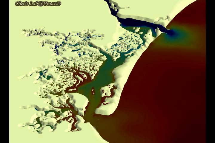
9 NERACOOS regional FVCOM grids Second Generation Third Generation Horizontal resolution: km in the coastal region; Sigma-coordinates: 31 vertical layers 300-m cutoff off Georges Bank Horizontal resolution: km in the coastal region; Generalized terrain-following coordinates: 46 layers: 10 uniform layers in the surface and bottom boundary layers, respectively m cutoff off Georges Bank Capable to nest to the coastal-estuarine model with a horizontal resolution of ~ m;


10

11

12
13
14 NECOFS Model Flow Diagram: 1.0 Stage: 1 (midnight) Crontab starts NECOFS Day 0 ~ now Day# wrf forecast data wrf hindcast data fvcom data (results) river data sst data Current Process 1: 2: 3: (Previous Hindcast) (Previous Forecast)
15 NECOFS Model Flow Diagram: 1.0 Stage: 2 (midnight) Update River Data Day# wrf forecast data wrf hindcast data fvcom data (results) river data sst data (Previous Hindcast) (Previous Forecast) Current Process 1: Download USGS data and update data file 2: 3:
16 NECOFS Model Flow Diagram: 1.0 Stage: 3 (00:10) Update SST Data Latest available SST data is already several days old Day# wrf forecast data wrf hindcast data fvcom data (results) river data sst data S 2 (Previous Hindcast) (Previous Forecast) Current Process 1: Download JPL SST and update OI assim 2: 3:
17 NECOFS Model Flow Diagram: 1.0 Stage: 4 (00:15) Run WRF wrf forecast data Continuous WRF data archive is automatically updated with new results Day# wrf hindcast data fvcom data (results) river data sst data S 3 S 2 (Previous Hindcast) (Previous Forecast) Current Process 1: WRF Forecast 2: WRF Hindcast 3:
18 NECOFS Model Flow Diagram: 1.0 Stage: 5 (08:00) Start FVCOM hindcast FVCOM overwrites old results updating time period of new WRF data. Day# wrf forecast data (Still running) wrf hindcast data fvcom data (results) river data sst data S 3 S 4 S 2 (Previous Hindcast) (Previous Forecast) Current Process 1: WRF Forecast 2: FVCOM Hindcast 3:
19 NECOFS Model Flow Diagram: 1.0 Stage: 6 (11:00) Start FVCOM Forecast FVCOM forecast runs till end of available WRF data Day# wrf forecast data wrf hindcast data fvcom data (results) river data sst data S 3 S 4 S 5 S 2 (Previous Hindcast) S 5 (Previous Forecast) Current Process 1: FVCOM Forecast 2: 3:
20 NECOFS Model Flow Diagram: 1.0 Stage: 7 (12:00) NECOFS Forecast Finished! New Results are Automatically posted to the web site! Day# wrf forecast data wrf hindcast data fvcom data (results) river data sst data S 3 S 4 S 2 S 5 S 5 S 6 (Previous Hindcast) (Previous Forecast) Current Process 1: 2: 3:

21

22
23
24 NECOFS - status 1. Now operational 24/7 in experimental mode 2. Model system description and forecasts available at NECOFS website: 3. Initial applications: a) surface weather and ice forecast data for NWS Taunton WFO; b) surface currents and winds for USCG search and research planning; c) surface forcing and currents in Buzzards Bay for research by USGS, in Nantucket Sound for WHOI/UMassD, in Plum Island Sound by MBL, Mass Bays for MWRA planning. 4. NERACOOS Storm Surge and Inundation project ( )
25 NECOFS storm surge and inundation system Definitions: Storm surge (SS) = surface elevation in model domain with tall walls at coastline (i.e., no flooding and drying) Inundation (In) = surface elevation in coastal region where flooding and drying can occur within model domain Objectives: Produce 3-d forecast of SS and related variables in coastal zone of regional model domain Produce surface and open ocean/land BC s to drive local FVCOM model to produce 3-d forecast of In and related variables Provide data in correct format for distribution through USGS
26 Steps: 1. Run NECOFS 3rd generation 3-D model to produce 3-d forecast of surface forcing, ocean fields 2. Use fields to force 2-D regional storm surge model to produce 3-d storm surge forecast and forcing fields for local inundation models 3. Use 2-D fields to force local 2-D inundation models (Saco, Scituate) 4. Distribute storm surge and inundation forecast results through USGS/GOMOOS 5..

27

28
29 Town Contacts: SACO, Maine Robert C. Bohlmann, Director, York County Emergency Management and Homeland Security Steve Boucouvalas, EMA Director, City Office of Emergency Management SCITUATE, Mass Neil F. Duggan, Scituate Inspection Department Building Zoning Enforcement Officer Other Contacts Wes Shaw, StormSmart Coasts Project Manager, Mass CZM Bob Thompson, Head, Taunton NWS Weather Forecast Office Ed Fratto, Executive Director, Northeast States Emergency Consortium (NESEC)
Advances in Coastal Inundation Simulation Using Unstructured-Grid Coastal Ocean Models
 Advances in Coastal Inundation Simulation Using Unstructured-Grid Coastal Ocean Models Bob Beardsley (WHOI) Changsheng Chen (UMass-Dartmouth) Bob Weisberg (U. South Florida) Joannes Westerink (U. Notre
An Unstructured Grid, Finite-Volume Coastal Ocean Model (FVCOM), Validations and Applications
, Validations and Applications") An Unstructured Grid, Finite-Volume Coastal Ocean Model (FVCOM), Validations and Applications Bob Beardsley, Changsheng Chen, and Geoff Cowles http://fvcom.smast.umassd.edu Data Assimilation in Support
An Unstructured Grid, Finite-Volume Coastal Ocean Model (FVCOM), Validations and Applications Bob Beardsley, Changsheng Chen, and Geoff Cowles http://fvcom.smast.umassd.edu Data Assimilation in Support
NORTHEAST COASTAL OCEAN FORECAST SYSTEM (NECOFS)
") NORTHEAST COASTAL OCEAN FORECAST SYSTEM (NECOFS) R. C. Beardsley and C. Chen MITSG 13-27 Sea Grant College Program Massachusetts Institute of Technology Cambridge, Massachusetts 02139 NOAA Grant No. NA10OAR4170086
NORTHEAST COASTAL OCEAN FORECAST SYSTEM (NECOFS) R. C. Beardsley and C. Chen MITSG 13-27 Sea Grant College Program Massachusetts Institute of Technology Cambridge, Massachusetts 02139 NOAA Grant No. NA10OAR4170086
Impact of Sea Level Rise on Future Storm-induced Coastal Inundation
 Impact of Sea Level Rise on Future Storm-induced Coastal Inundation Changsheng Chen School for Marine Science and Technology, University of Massachusetts-Dartmouth Email: c1chen@umassd.edu 04/14/2015 Outline
Critical Issues in Assessment of Offshore Wind Farm Development on Dispersion and Settling of Scallop Larvae in the Northeast U.S.
 Critical Issues in Assessment of Offshore Wind Farm Development on Dispersion and Settling of Scallop Larvae in the Northeast U.S. Coastal Ocean Changsheng Chen School for Marine Science and Technology
Topics 1. IOOS on the US East Coast. 2. Regional Physical & Ecosystem Modeling Efforts
 Topics 1. IOOS on the US East Coast National Federation of Regional Associations http://usnfra.org - NERACOOS - MACOORA 2. Regional Physical & Ecosystem Modeling Efforts Northeast Regional Association
DEVELOPMENT OF AN INUNDATION FORECAST SYSTEM FOR MASSACHUSETTS COASTAL WATERS
 DEVELOPMENT OF AN INUNDATION FORECAST SYSTEM FOR MASSACHUSETTS COASTAL WATERS C. Chen and R. C. Beardsley MITSG 13-26 Sea Grant College Program Massachusetts Institute of Technology Cambridge, Massachusetts
Coastal Cities-Coastal Impacts: 'The Tides They Are A-Changin
 Coastal Cities-Coastal Impacts: 'The Tides They Are A-Changin Susan K. Avery Woods Hole Oceanographic Institution Thanks to: Jeff Donnelly, Chris Reddy, Porter Hoagland, Jim Price, Dennis McGillicuddy,
Flood and Sea Level Rise Mapping Methodologies: The Way Forward
 Flood and Sea Level Rise Mapping Methodologies: The Way Forward Malcolm L. Spaulding Professor Emeritus, Ocean Engineering University of Rhode Island spaulding@egr.uri.edu Interagency Coordination Meeting
Coastal Emergency Risks Assessment - CERA Real-Time Storm Surge and Wave Visualization Tool
 Coastal Emergency Risks Assessment - CERA Real-Time Storm Surge and Wave Visualization Tool Introduction This document provides guidance for using the Coastal Emergency Risks Assessment (CERA) visualization
NWS Operational Marine and Ocean Forecasting. Overview. Ming Ji. Ocean Prediction Center National Weather Service/NCEP. CIOSS/CoRP
 NWS Operational Marine and Ocean Forecasting Overview Ming Ji Ocean Prediction Center National Weather Service/NCEP CIOSS/CoRP CoRP Symposium Corvallis, OR Aug. 12-13, 13, 2008 Titanic Telegram Marine
Robert Weaver, Donald Slinn 1
 1 1 Robert Weaver, Donald Slinn 1 Department of Civil and Coastal Engineering, University of Florida, Gainesville, Florida Supported by the US Office of Naval Research AGU Fall Meeting 2002 Poster OS72A-0342
What is CERA? Coastal Emergency Risks Assessment
 What is CERA? Coastal Emergency Risks Assessment Visualization tool using OGC standards Displays the outputs from the ADCIRC storm surge model or other coastal models Represents the maps on interactive
Saiful Islam Anisul Haque
 Workshop on Disaster Prevention/Mitigation Measures against Floods and Storm Surges in Bangladesh on 17-21 November, 2012, in Kyoto University, Japan Component 2: Flood disaster risk assessment and mitigation
John Kindle. Sergio derada Igor Shulman Ole Martin Smedstad Stephanie Anderson. Data Assimilation in Coastal Modeing April
 John Kindle Sergio derada Igor Shulman Ole Martin Smedstad Stephanie Anderson Data Assimilation in Coastal Modeing April 3 2007 MODELS Motivation: Global->Coastal Real-Time Regional Coastal Models Global
Implementation of SWAN model with COSMO-CLM and WRF-ARW wind forcing for the Barents Sea storm events (case study).
.") IGU Regional Conference Moscow 2015 Implementation of SWAN model with COSMO-CLM and WRF-ARW wind forcing for the Barents Sea storm events (case study). Stanislav Myslenkov 1, Vladimir Platonov 2 and Pavel
IGU Regional Conference Moscow 2015 Implementation of SWAN model with COSMO-CLM and WRF-ARW wind forcing for the Barents Sea storm events (case study). Stanislav Myslenkov 1, Vladimir Platonov 2 and Pavel
Adapting NEMO for use as the UK operational storm surge forecasting model
 Adapting NEMO for use as the UK operational storm surge forecasting model Rachel Furner 1, Jane Williams 2, Kevin Horsburgh 2, Andy Saulter 1 1; Met Office 2; NOC Table of Contents Existing CS3 model Developments
POLCOMS Metadata for the ARCoES project Keywords: POLCOMS, WAM, residual circulation, waves, Liverpool Bay, UK shelf
 POLCOMS Metadata for the ARCoES project Keywords: POLCOMS, WAM, residual circulation, waves, Liverpool Bay, UK shelf POLCOMS is the Proudman Oceanographic Laboratory Coastal Ocean Modelling System. It
John Callahan (Delaware Geological Survey) Kevin Brinson, Daniel Leathers, Linden Wolf (Delaware Environmental Observing System)
 Kevin Brinson, Daniel Leathers, Linden Wolf (Delaware Environmental Observing System)") John Callahan (Delaware Geological Survey) Kevin Brinson, Daniel Leathers, Linden Wolf (Delaware Environmental Observing System) Delaware is extremely vulnerable to the impacts of coastal flooding Tropical
John Callahan (Delaware Geological Survey) Kevin Brinson, Daniel Leathers, Linden Wolf (Delaware Environmental Observing System) Delaware is extremely vulnerable to the impacts of coastal flooding Tropical
Lecture-1: FVCOM-An unstructured grid Finite-Volume Community Ocean Model
 Lecture-1: FVCOM-An unstructured grid Finite-Volume Community Ocean Model Changsheng Chen School for Marine Science and Technology University of Massachusetts-Dartmouth New Bedford, MA 02744 Email: c1chen@umassd.edu,
An Investigation of the Influence of Waves on Sediment Processes in Skagit Bay
 DISTRIBUTION STATEMENT A. Approved for public release; distribution is unlimited. An Investigation of the Influence of Waves on Sediment Processes in Skagit Bay Geoffrey W. Cowles School for Marine Science
West Florida Shelf and Tampa Bay Responses to Hurricane Irma: What Happened and Why
 West Florida Shelf and Tampa Bay Responses to Hurricane Irma: What Happened and Why R.H. Weisberg Y. Liu J. Chen College of Marine Science University of South Florida St. Petersburg, FL SECOORA Webinar
ERDC Support for Hurricane Sandy
 ERDC Support for Hurricane Sandy Chris Massey, CHL; Aaron Byrd, CHL; Nawa Pradhan, CHL; Jeff Melby, CHL; Jane Smith, CHL; Robert Walker, ITL; and Jennifer Wozencraft, JALBTCX ERDC Support for Hurricane
M. Liste 1, M. Grifoll 2, I. Keupers 1, J. Fernández 3, H. Ortega 1, J. Monbaliu 1
 M. Liste 1, M. Grifoll 2, I. Keupers 1, J. Fernández 3, H. Ortega 1, J. Monbaliu 1 1 Hydraulics Laboratory (K.U.Leuven, Belgium) 2 Laboratori d Enginyeria Marítima (LIM/UPC, Spain) 3 SIMO, Spain. Motivation
Casco Bay Estuary Partnership (CBEP) USM Muskie School 34 Bedford St 228B. Portland, ME
 USM Muskie School 34 Bedford St 228B. Portland, ME") Casco Bay Estuary Partnership (CBEP) USM Muskie School 34 Bedford St 228B Wishcamper Center Portland, ME 04104 9300 Malcolm L. Spaulding Applied Science Associates 55 Village Square Drive South Kingstown,
Casco Bay Estuary Partnership (CBEP) USM Muskie School 34 Bedford St 228B Wishcamper Center Portland, ME 04104 9300 Malcolm L. Spaulding Applied Science Associates 55 Village Square Drive South Kingstown,
Simulation of storm surge and overland flows using geographical information system applications
 Coastal Processes 97 Simulation of storm surge and overland flows using geographical information system applications S. Aliabadi, M. Akbar & R. Patel Northrop Grumman Center for High Performance Computing
Operational Estuarine & Coastal Forecast Systems in NOAA s. National Ocean Service
 Operational Estuarine & Coastal Forecast Systems in NOAA s. National Ocean Service Eugene Wei, Frank Aikman III and Richard Patchen NOAA S S National Ocean Service Workshop on: Data Assimilation in Support
Research of the Influential Factors on the Simulation of Storm Surge in the Bohai Sea
 Send Orders for Reprints to reprints@benthamscience.net The Open Mechanical Engineering Journal, 2014, 8, 151-156 151 Open Access Research of the Influential Factors on the Simulation of Storm Surge in
CERA-Atlantic Storm Surge Web Page: Improvements for 2013 Based on EM Feedback
 CERA-Atlantic Storm Surge Web Page: Improvements for 2013 Based on EM Feedback Jessica Losego Meteorologist University of North Carolina - Institute for the Environment Rick Luettich Director, UNC IMS
Development of a coastal modeling system
 Development of a coastal modeling system John Warner US Geological Survey Coastal and Marine Geology Program Woods Hole, MA U.S. Department of the Interior U.S. Geological Survey Jeff List Rob Thieler
New Directions in Catastrophe Risk Models
 New Directions in Catastrophe Risk Models World Bank Brown-Bag Lunch Presentation October 9, 2007 Richard J. Murnane Baseline Management Company, Inc. Overview! Background on reinsurance and cat models!
Estimation of Wave Heights during Extreme Events in Lake St. Clair
 Abstract Estimation of Wave Heights during Extreme Events in Lake St. Clair T. J. Hesser and R. E. Jensen Lake St. Clair is the smallest lake in the Great Lakes system, with a maximum depth of about 6
National Centers for Environmental Prediction: Building a Weather-Ready Nation
 National Centers for Environmental Prediction: Building a Weather-Ready Nation Dr. William M. Lapenta Director, National Centers for Environmental Prediction NOAA/National Weather Service COPC meeting
COASTAL DATA APPLICATION
 2015 Coastal GeoTools Proactive By Design. Our Company Commitment COASTAL DATA APPLICATION Projecting Future Coastal Flood Risk for Massachusetts Bay Bin Wang, Tianyi Liu, Daniel Stapleton & Michael Mobile
Overview of NOS Coastal Ocean Operational Forecast Systems
 Overview of NOS Coastal Ocean Operational Forecast Systems Aijun Zhang NOAA/NOS Center for Operational Oceanographic Products and Services (CO-OPS) Frank Aikman III NOAA/NOS/OCS Coast Survey Development
An Integrated Storm Surge, Hurricane Wave, Salinity and Sediment Transport Modeling System for Breton Sound, LA
 An Integrated Storm Surge, Hurricane Wave, Salinity and Sediment Transport Modeling System for Breton Sound, LA Q. Jim Chen Department of Civil and Environmental Engineering qchen@lsu.edu Acknowledgements
MAR513 Lecture 10: Pressure Errors in Terrain-Following Coordinates
 MAR513 Lecture 10: Pressure Errors in Terrain-Following Coordinates The vertical coordinates: The z-coordinate The Terrain-following coordinate Advantage: Simple Disadvantage: Poorly resolve topography
Nor easter Monday Night Wednesday December 8 10, 2014
 Nor easter Monday Night Wednesday December 8 10, 2014 Prepared 400 PM EST Monday, December 8, 2014 Mitchell Gaines NOAA s Philadelphia/Mount Holly NJ Forecast Office www.weather.gov/phi/ Purpose of Briefing
THC-T-2013 Conference & Exhibition
 Modeling of Shutter Coastal Protection against Storm Surge for Galveston Bay C. Vipulanandan, Ph.D., P.E., Y. Jeannot Ahossin Guezo and and B. Basirat Texas Hurricane Center for Innovative Technology (THC-IT)
Storm surge forecasting and other Met Office ocean modelling
 Storm surge forecasting and other Met Office ocean modelling EMODnet stakeholder meeting Clare O Neill + many others Outline Ocean modelling at the Met Office Storm surge forecasting Current operational
Introduction of Korea Operational Oceanographic System (KOOS)
") PICES-2010, Portland, USA October 21-31, 2010 Introduction of Korea Operational Oceanographic System (KOOS) Oct. 28, 2010 Kwang-Soon Park, Dong-Young Lee, Ki-Cheon Jun, Sang-Ik Kim, Jae-Il Kwon and Jung-Woon
PICES-2010, Portland, USA October 21-31, 2010 Introduction of Korea Operational Oceanographic System (KOOS) Oct. 28, 2010 Kwang-Soon Park, Dong-Young Lee, Ki-Cheon Jun, Sang-Ik Kim, Jae-Il Kwon and Jung-Woon
Overview of HYCOM activities at SHOM
 Overview of HYCOM activities at SHOM Stéphanie Louazel, Stéphanie Corréard, Rémy Baraille, Annick Pichon, Cyril Lathuilière, Audrey Pasquet, Emeric Baquet LOM2015 Copenhagen 2 nd 4 th June 2015 French
Developing Coastal Ocean Forecasting Systems and Their Applications
 Developing Coastal Ocean Forecasting Systems and Their Applications Xiaochun Wang a,b LASG/IAP, CAS, July 23, 2010 Contributions from: JPL Yi Chao, John Farrara, Peggy Li, Zhijin Li, Quoc Vu, Hongchun
Recent Developments in the Navy Coastal Ocean Model and its application as the ocean component in regional coupled forecast models
 Recent Developments in the Navy Coastal Ocean Model and its application as the ocean component in regional coupled forecast models Tommy Jensen, Paul Martin, Clark Rowley, Tim Campbell, Richard Allard,
NOAA Inundation Dashboard
 NOAA Inundation Dashboard Audra Luscher & Paul Fanelli NOS Center for Operational Oceanographic Products & Services (CO-OPS) Hampton Roads Sea Level Rise/Flooding Adaptation Forum July 29, 2016 http://tidesandcurrents.noaa.gov/inundationdb/newyork.html
Impact of current-wave interaction on storm surge simulation: A case study for Hurricane Bob
 JOURNAL OF GEOPHYSICAL RESEARCH: OCEANS, VOL. 118, 2685 2701, doi:10.1002/jgrc.20207, 2013 Impact of current-wave interaction on storm surge simulation: A case study for Hurricane Bob Yunfang Sun, 1 Changsheng
Coupled Wind, Wave, and Surge Modeling. Pat Welsh University of North Florida 10th International Wave Conference 12 November 2007
 Coupled Wind, Wave, and Surge Modeling Pat Welsh University of North Florida 10th International Wave Conference 12 November 2007 Current AWIS Lab Project & Proposals Collaborators Our Lab is too small
Advanced Hurricane WRF (AHW) Physics
 Physics") Advanced Hurricane WRF (AHW) Physics Jimy Dudhia MMM Division, NCAR 1D Ocean Mixed-Layer Model 1d model based on Pollard, Rhines and Thompson (1973) was added for hurricane forecasts Purpose is to represent
Advanced Hurricane WRF (AHW) Physics Jimy Dudhia MMM Division, NCAR 1D Ocean Mixed-Layer Model 1d model based on Pollard, Rhines and Thompson (1973) was added for hurricane forecasts Purpose is to represent
Wave Forecast and Wave Climate, Advances and Challenges
 Wave Forecast and Wave Climate, Advances and Challenges Alexander Babanin, Ian Young and Stefan Zieger Swinburne University, Melbourne Australian National University, Canberra Australian Bureau of Meteorology,
Agenda FVCOM Users Workshop Bedford Institute of Oceanography, Dartmouth October 20-22, Oral Program. Day 1: October 20
 Agenda FVCOM Users Workshop Bedford Institute of Oceanography, Dartmouth October 20-22, 2015 Oral Program 8:30 Registration Day 1: October 20 9:00 Welcome S. Haigh/D. Greenberg Session 1 C. Chen 9:10 A
Numerical Weather Prediction. Meteorology 311 Fall 2010
 Numerical Weather Prediction Meteorology 311 Fall 2010 Closed Set of Equations Same number of equations as unknown variables. Equations Momentum equations (3) Thermodynamic energy equation Continuity equation
Assimilation Impact of Physical Data on the California Coastal Ocean Circulation and Biogeochemistry
 Assimilation Impact of Physical Data on the California Coastal Ocean Circulation and Biogeochemistry Yi Chao, Remote Sensing Solutions (RSS)/UCLA; John D. Farrara, RSS; Fei Chai, University of Maine; Hongchun
5. General Circulation Models
 5. General Circulation Models I. 3-D Climate Models (General Circulation Models) To include the full three-dimensional aspect of climate, including the calculation of the dynamical transports, requires
Moving to a simpler NCEP production suite
 Moving to a simpler NCEP production suite Unified coupled global modeling Hendrik L. Tolman Director, Environmental Modeling Center NOAA / NWS / NCEP Hendrik.Tolman@NOAA.gov page 1 of 14 Content The suite
NOAA s National Weather Service Philadelphia/Mt. Holly NJ
 Snow and Coastal Flooding through this evening Hazards and Impacts: Coastal Flooding: With the persistent onshore flow, and a new moon yesterday, coastal flooding is expected at high tide today. Moderate
A Realtime Forecasting System for the Chesapeake Bay Tributaries: Interoperability and Metadata for Automation
 A Realtime Forecasting System for the Chesapeake Bay Tributaries: Interoperability and Metadata for Automation David Forrest Virginia Institute of Marine Science drf@vims.edu East Coast ELCIRC grid Mixed
Study on Air-Sea Interaction under Typhoon and Its Application of Two Important Projects
 ESCAP/WMO Typhoon Committee Technical Conference (TC50 TECO) Study on Air-Sea Interaction under Typhoon and Its Application of Two Important Projects Li Yongping Shanghai Typhoon Institute/CMA 2018.02.26
Earth Observation in coastal zone MetOcean design criteria
 ESA Oil & Gas Workshop 2010 Earth Observation in coastal zone MetOcean design criteria Cees de Valk BMT ARGOSS Wind, wave and current design criteria geophysical process uncertainty modelling assumptions
Richard M. Yablonsky University of Rhode Island. WRF for Hurricanes Tutorial Boulder, CO 25 February 2010
 Richard M. Yablonsky University of Rhode Island WRF for Hurricanes Tutorial Boulder, CO 25 February 2010 1 What is the Princeton Ocean Model? Three dimensional, primitive equation, numerical ocean model
A Cloud-Based Flood Warning System For Forecasting Impacts to Transportation Infrastructure Systems
 A Cloud-Based Flood Warning System For Forecasting Impacts to Transportation Infrastructure Systems Jon Goodall Associate Professor, Civil and Environmental Engineering Associate Director, Link Lab April
Hyperlocal Marine Weather: What s Happening?
 Hyperlocal Marine Weather: What s Happening? André van der Westhuysen 1,2 and Jeff McQueen 1 1 NOAA / National Weather Service National Centers for Environmental Prediction 2 I.M Systems Group, Rockville
Tropical Update. 11 AM EDT Wednesday, October 10, 2018 Hurricane Michael, Hurricane Leslie & Tropical Storm Nadine, Caribbean Low (40%)
") Tropical Update 11 AM EDT Wednesday, October 10, 2018 Hurricane Michael, Hurricane Leslie & Tropical Storm Nadine, Caribbean Low (40%) This update is intended for government and emergency response officials,
Tropical Update 11 AM EDT Wednesday, October 10, 2018 Hurricane Michael, Hurricane Leslie & Tropical Storm Nadine, Caribbean Low (40%) This update is intended for government and emergency response officials,
Numerical Weather Prediction. Meteorology 311 Fall 2016
 Numerical Weather Prediction Meteorology 311 Fall 2016 Closed Set of Equations Same number of equations as unknown variables. Equations Momentum equations (3) Thermodynamic energy equation Continuity equation
Computing the Joint Probability of Hurricane Sandy and Historical Coastal Storm Forcing Parameters from Maine to Virginia
 Computing the Joint Probability of Hurricane Sandy and Historical Coastal Storm Forcing Parameters from Maine to Virginia Chris Massey and Jeff Melby USACE-ERDC Coastal & Hydraulics Lab Chris.Massey@usace.army.mil
3.6 EFFECTS OF WINDS, TIDES, AND STORM SURGES ON OCEAN SURFACE WAVES IN THE JAPAN/EAST SEA
 3.6 EFFECTS OF WINDS, TIDES, AND STORM SURGES ON OCEAN SURFACE WAVES IN THE JAPAN/EAST SEA Wei Zhao 1, Shuyi S. Chen 1 *, Cheryl Ann Blain 2, Jiwei Tian 3 1 MPO/RSMAS, University of Miami, Miami, FL 33149-1098,
Case study analysis of the Real-Time Mesoscale Analysis (RTMA) in the northern Gulf of Mexico
 in the northern Gulf of Mexico") Case study analysis of the Real-Time Mesoscale Analysis (RTMA) in the northern Gulf of Mexico Pat Fitzpatrick and Yee Lau Mississippi State University Stennis Space Center, MS Description of research consortium
Case study analysis of the Real-Time Mesoscale Analysis (RTMA) in the northern Gulf of Mexico Pat Fitzpatrick and Yee Lau Mississippi State University Stennis Space Center, MS Description of research consortium
Coastal Inundation Forecasting and Community Response in Bangladesh
 WMO Coastal Inundation Forecasting and Community Response in Bangladesh Bapon (SHM) Fakhruddin Nadao Kohno 12 November 2015 System Design for Coastal Inundation Forecasting CIFDP-PSG-5, 14-16 May 2014,
Arctic System Reanalysis Provides Highresolution Accuracy for Arctic Studies
 Arctic System Reanalysis Provides Highresolution Accuracy for Arctic Studies David H. Bromwich, Aaron Wilson, Lesheng Bai, Zhiquan Liu POLAR2018 Davos, Switzerland Arctic System Reanalysis Regional reanalysis
USACE-ERDC Coastal Storm Modeling System Updates Chris Massey, PhD
 USACE-ERDC Coastal Storm Modeling System Updates Chris Massey, PhD Research Mathematician USACE-ERDC Coastal & Hydraulics Lab Chris.Massey@usace.army.mil ERDC s Coastal Storm-Modeling System (ERDC CSTORM-MS)
Alexander Barth, Aida Alvera-Azc. Azcárate, Robert H. Weisberg, University of South Florida. George Halliwell RSMAS, University of Miami
 Ensemble-based based Assimilation of HF-Radar Surface Currents in a West Florida Shelf ROMS Nested into HYCOM and filtering of spurious surface gravity waves. Alexander Barth, Aida Alvera-Azc Azcárate,
Polar Weather Prediction
 Polar Weather Prediction David H. Bromwich Session V YOPP Modelling Component Tuesday 14 July 2015 A special thanks to the following contributors: Kevin W. Manning, Jordan G. Powers, Keith M. Hines, Dan
HY-2A Satellite User s Guide
 National Satellite Ocean Application Service 2013-5-16 Document Change Record Revision Date Changed Pages/Paragraphs Edit Description i Contents 1 Introduction to HY-2 Satellite... 1 2 HY-2 satellite data
J-Rapid PI: Jun Sasaki 1 T. Suzuki 1 and R. U. A. Wiyono 1. Rapid PI: Changsheng Chen 2 C. Beardsley 3, Z. Lai 2, R., H. Lin 2, J. Lin 3 and R.
 Collaborative Research: The Japan March 11 Earthquake: Tsunami inundation, and initial spread of Fukushima Dai-ichi Radionuclides into the Pacific Ocean: Model Assessment J-Rapid PI: Jun Sasaki 1 T. Suzuki
Cold air outbreak over the Kuroshio Extension Region
 Cold air outbreak over the Kuroshio Extension Region Jensen, T. G. 1, T. Campbell 1, T. A. Smith 1, R. J. Small 2 and R. Allard 1 1 Naval Research Laboratory, 2 Jacobs Engineering NRL, Code 7320, Stennis
Hindcast Arabian Gulf
 Hindcast Arabian Gulf Image of isobars of atmospheric pressure and hindcast wind- and wave field over the Arabian Gulf during a storm in January 1993. Detailed wave studies are supported by nesting of
Major Hurricane Earl
 Major Hurricane Earl Advisory 32 North Carolina Threat Assessment Prepared at: 8 AM Thursday September 2, 2010 Hurricane and Tropical Storm Warnings in effect for the North Carolina Coast and Sounds. NWS
SLOSH New Orleans Basin 2012 Update
 SLOSH New Orleans Basin 2012 Update Michael Koziara Science and Operations Officer National Weather Service Slidell, LA The Basics What is storm surge? What is SLOSH? Details Assumptions Inundation = Storm
The Heat Budget for Mt. Hope Bay
 The School for Marine Science and Technology The Heat Budget for Mt. Hope Bay Y. Fan and W. Brown SMAST, UMassD SMAST Technical Report No. SMAST-03-0801 The School for Marine Science and Technology University
Tampa Bay Storm Surge & Wave Vulnerability, Response to Hurricane Irma and Tools for Future Use
 Tampa Bay Storm Surge & Wave Vulnerability, Response to Hurricane Irma and Tools for Future Use Robert H. Weisberg with J. Chen, Y. Liu and L. Zheng College of Marine Science University of South Florida
Numerical Weather Prediction: Data assimilation. Steven Cavallo
 Numerical Weather Prediction: Data assimilation Steven Cavallo Data assimilation (DA) is the process estimating the true state of a system given observations of the system and a background estimate. Observations
1.2 DEVELOPMENT OF THE NWS PROBABILISTIC EXTRA-TROPICAL STORM SURGE MODEL AND POST PROCESSING METHODOLOGY
 1.2 DEVELOPMENT OF THE NWS PROBABILISTIC EXTRA-TROPICAL STORM SURGE MODEL AND POST PROCESSING METHODOLOGY Huiqing Liu 1 and Arthur Taylor 2* 1. Ace Info Solutions, Reston, VA 2. NOAA / NWS / Science and
Polar COAWST. Coupled Atmosphere (Land) Ocean Sea Ice Wave Sediment Transport Modeling System for Polar Regions
 Ocean Sea Ice Wave Sediment Transport Modeling System for Polar Regions") U.S. Department of the Interior U.S. Geological Survey Polar COAWST Coupled Atmosphere (Land) Ocean Sea Ice Wave Sediment Transport Modeling System for Polar Regions David Bromwich 1, Le-Sheng Bai 1 Michael
U.S. Department of the Interior U.S. Geological Survey Polar COAWST Coupled Atmosphere (Land) Ocean Sea Ice Wave Sediment Transport Modeling System for Polar Regions David Bromwich 1, Le-Sheng Bai 1 Michael
Ocean Model Development for COAMPS
 Ocean Model Development for COAMPS Paul Martin Naval Research Laboratory Stennis Space Center, MS 39529 phone: (228) 688-5447 fax: (228) 688-4759 email: martin@nrlssc.navy.mil Award #: N0001498WX30328
HWRF Ocean: MPIPOM-TC
 HWRF v3.7a Tutorial Nanjing, China, December 2, 2015 HWRF Ocean: MPIPOM-TC Ligia Bernardet NOAA SRL Global Systems Division, Boulder CO University of Colorado CIRS, Boulder CO Acknowledgement Richard Yablonsky
A process-based approach toward assessing the coastal impact of projected sea level rise and severe storms
 A process-based approach toward assessing the coastal impact of projected sea level rise and severe storms Patrick Barnard 1, Cheryl Hapke 2, Li Erikson 1, Amy Foxgrover 1, and Maarten van Ormondt 3 1
HYCOM in the South Atlantic Bight: Performance and Client Applications
 HYCOM in the South Atlantic Bight: Performance and Client Applications Brian Blanton, Alfredo Aretxabaleta Department of Marine Sciences UNC-Chapel Hill UNC Group Activities HYCOM/GODAE NOPP Provide SEACOOS
Coastal Inundation Risk for SE Florida Incorporating Climate Change Impact on Hurricanes & Sea Level Rise
 Coastal Inundation Risk for SE Florida Incorporating Climate Change Impact on Hurricanes & Sea Level Rise Y. Peter Sheng and V.A. Paramygin Justin R. Davis, Andrew Condon, Andrew Lapetina, Tianyi Liu,
INFLUENCE OF SEA SURFACE TEMPERATURE ON COASTAL URBAN AREA - CASE STUDY IN OSAKA BAY, JAPAN -
 Proceedings of the Sixth International Conference on Asian and Pacific Coasts (APAC 2011) December 14 16, 2011, Hong Kong, China INFLUENCE OF SEA SURFACE TEMPERATURE ON COASTAL URBAN AREA - CASE STUDY
The North Carolina State University coastal and estuary storm surge and flood prediction system
 The North Carolina State University coastal and estuary storm surge and flood prediction system L. J. Pietrafesa, L. Xie, D. A. Dickey, M. C. Peng & S. Yan College of Physical & Mathematical Sciences,
P2.57 Cyclone Yasi Storm Surge in Australia Implications for Catastrophe Modeling
 P2.57 Cyclone Yasi Storm Surge in Australia Implications for Catastrophe Modeling Kevin A. Hill*, Peter Sousounis, and Jason Butke AIR Worldwide Corporation, Boston, Massachusetts 1. INTRODUCTION Storm
THE INFLUENCE OF HIGHLY RESOLVED SEA SURFACE TEMPERATURES ON METEOROLOGICAL SIMULATIONS OFF THE SOUTHEAST US COAST
 THE INFLUENCE OF HIGHLY RESOLVED SEA SURFACE TEMPERATURES ON METEOROLOGICAL SIMULATIONS OFF THE SOUTHEAST US COAST Peter Childs, Sethu Raman, and Ryan Boyles State Climate Office of North Carolina and
O.M Smedstad 1, E.J. Metzger 2, R.A. Allard 2, R. Broome 1, D.S. Franklin 1 and A.J. Wallcraft 2. QinetiQ North America 2. Naval Research Laboratory
 An eddy-resolving ocean reanalysis using the 1/12 global HYbrid Coordinate Ocean Model (HYCOM) and the Navy Coupled Ocean Data Assimilation (NCODA) scheme O.M Smedstad 1, E.J. Metzger 2, R.A. Allard 2,
Frank Revitte National Weather Service. Weather Forecast Office New Orleans/Baton Rouge
 Frank Revitte National Weather Service Weather Forecast Office New Orleans/Baton Rouge Above normal activity 17 Total Named Storms 7 Tropical Storms 4 Hurricanes 6 Major Hurricanes Not the most active,
Indian Ocean Forecast System (INDOFOS) Abhisek Chatterjee
 Abhisek Chatterjee") Indian Ocean Forecast System (INDOFOS) Abhisek Chatterjee Earth System Sciences Organisation (ESSO) Indian National Centre for Ocean Information Services (INCOIS) Ministry of Earth Sciences, Government
Indian Ocean Forecast System (INDOFOS) Abhisek Chatterjee Earth System Sciences Organisation (ESSO) Indian National Centre for Ocean Information Services (INCOIS) Ministry of Earth Sciences, Government
Coastal Tidal Marshes
 Virginia s Wetlands Coastal Tidal Marshes Hydrology driven by lunar tides; Stresses include tidal inundation and/or salts; Found along high latitudes along intertidal coasts; Comprise ~ 70% wetlands of
WRF Modeling System Overview
 WRF Modeling System Overview Louisa Nance National Center for Atmospheric Research (NCAR) Developmental Testbed Center (DTC) 27 February 2007 1 Outline What is WRF? WRF Modeling System WRF Software Design
Adaptation to Sea Level Rise A Regional Approach
 Adaptation to Sea Level Rise A Regional Approach Project Partners: in Saco Bay, ME Peter Slovinsky, Marine Geologist Maine Geological Survey, Department of Conservation Project Funding from: Saco Bay Hazards
Tropical Weather Briefing
 Tropical Weather Briefing August 28, 2012 700 AM CDT National Weather Service Weather Forecast Office Slidell, LA Current Satellite Tropical Storm Isaac Watches/Warnings Tropical Storm Isaac Track Guidance
Forecast of Nearshore Wave Parameters Using MIKE-21 Spectral Wave Model
 Forecast of Nearshore Wave Parameters Using MIKE-21 Spectral Wave Model Felix Jose 1 and Gregory W. Stone 2 1 Coastal Studies Institute, Louisiana State University, Baton Rouge, LA 70803 2 Coastal Studies
Tropical Update. 5 AM EDT Tuesday, September 12, 2017 Post-Tropical Cyclone Irma, Hurricane Jose, & Tropical Wave (10%)
") Tropical Update 5 AM EDT Tuesday, September 12, 2017 Post-Tropical Cyclone Irma, Hurricane Jose, & Tropical Wave (10%) This update is intended for government and emergency response officials, and is provided
Tropical Update 5 AM EDT Tuesday, September 12, 2017 Post-Tropical Cyclone Irma, Hurricane Jose, & Tropical Wave (10%) This update is intended for government and emergency response officials, and is provided