The Pontchartrain Maurepas Surge Consortium (LPMSC) Lake Sloshing Effect Preliminary Findings
|
|
|
- Patrick Byrd
- 5 years ago
- Views:
Transcription

1 The Pontchartrain Maurepas Surge Consortium (LPMSC) Lake Sloshing Effect Preliminary Findings Lake Pontchartrain Basin Foundation John A. Lopez, Ph.D. with contributions from Dr. Joe Suhayda, Dr. Hal Needham, and Dr. Ezra Boyd workshop held Feb April 16, 2015 South Louisiana Flood Protection Authority East Board Meeting Kenner, La SaveOurLake.org
2 Pontchartrain Maurepas Surge Consortium Mission The LPMSC mission is to leverage local expertise with additional technical resources in a regional collaboration that will promote a broader understanding of storm surge dynamics in the lakes, and abetter informed storm surge risk reduction strategies for all communities around the Lakes to bolster the environmental sustainability, community resilience, and safety of residents through enhancement of storm surge risk management.


3 Regional Authorities Participating CPRA NWS LPBF LSU Climate Center La DHS
4 Presentation of surge data is often the maximum surge during storm passage and so is a composite over time masking the actual storm surge movement details including model data and observed storm surge elevations.
5
6
7 Water Surface Elevation Profile - North Transect 100-Year Event 400-Year Event 1000-Year Event Feet Interstate 10 Lake Pontchartrain Shoreline Lake St. Catherine Shoreline Lake St. Catherine Shoreline Lake Borgne Shoreline Lake Pontchartrain East Orleans Land Bridge Lake Borgne
8 Composite maximum surge Incoming surge Outgoing surge

9 Empirically Derived Storm Surge Return Levels Image: Time News Feed How often does a surge of this magnitude occur? Contact info: Hal Needham hal@srcc.lsu.edu
10
11 Empirical Storm Surge Return Levels around Lake Pontchartrain Location 50 yr 100 yr 200 yr 500 yr New Orleans Lakefront Frenier Mandeville Slidell Units: Feet above Mean Sea Level (MSL) Hal Needham
12 High Water Records around Lake Pontchartrain Location Storm Year Water Level Datum Year Event New Orleans Katrina NAVD88 98 Lakefront Frenier Betsy Unknown 115 Mandeville Katrina NAVD88 78 Slidell Katrina NAVD Hal Needham

13 Links/ Contact Info SCIPP SURGEDAT Contact info: Hal Needham
14 The Lake Pontchartrain sloshing effect is principally due to wind stress, wind driven waves and surge flux, which vary during storm Passage. The Variables Influencing Wind Driven Waves: Wind Speed Fetch Width of area affected by a wind field, i.e. open water that the wind is blowing Wind duration Water depth
15 30 Lake Maurepas Maurepas Landbridge Lake Pontchartrain East Orleans Landbridge Mississippi Sound
16
17

18 30 Lake Maurepas Maurepas Landbridge Lake Pontchartrain East Orleans Landbridge Mississippi Sound Direction and Length of Maximum Fetch ESE >75 SSW to SE 25 WSW 29 W 52 ENE 45 WNW 43 N 25
19
20 Surge Transmission Potential function of cross section area and boundary resistance IHNC closed Positive surge head
21 Surge Transmission Potential function of cross section area and boundary resistance IHNC closed Negative surge head
22 SE 16 SSE 15 SW 14 ENE 22 WNW 10 NNE 10
23 LP Soft and Equidistant Hard and Convergent
24
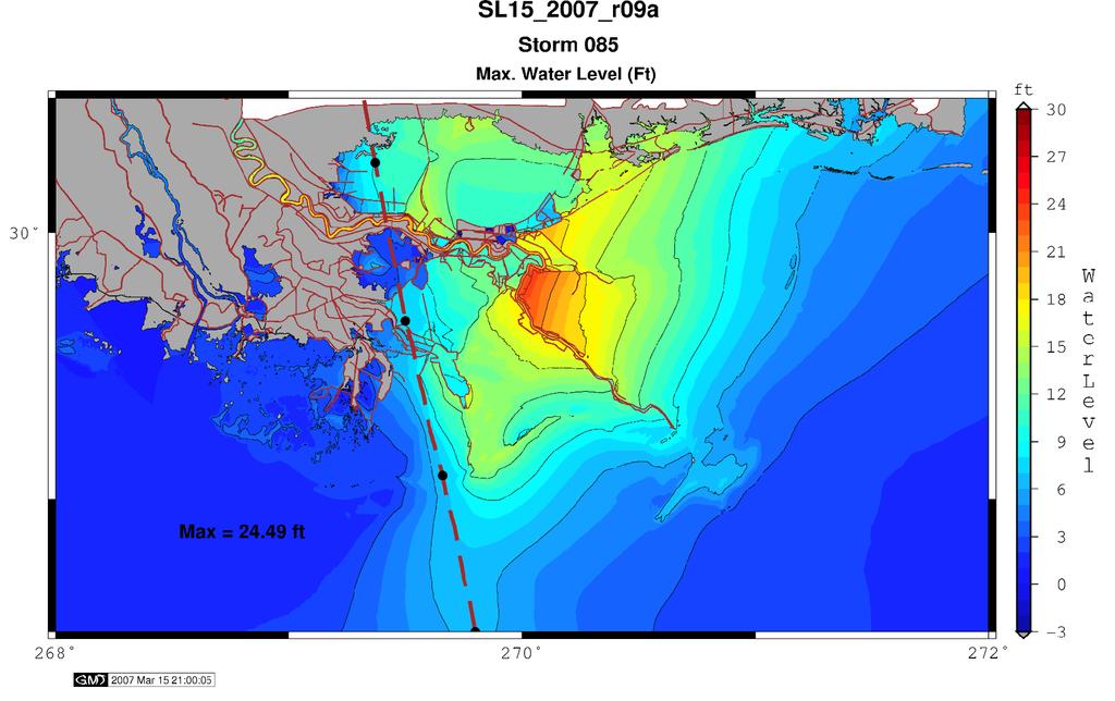
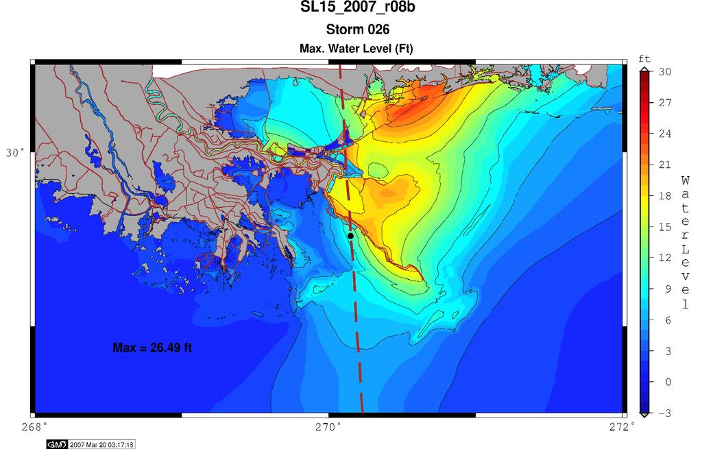
25 Lake Maurepas Lake Pontchartrain Track East of New Orleans Eye far southeast of LP Pre wind surge Mississippi Sound Eye East of LP Wind & Surge effect Eye northeast of LP Wind & Surge discharge effect
26 Lake Maurepas Lake Pontchartrain Track East of New Orleans Eye far southeast of LP Pre wind surge Mississippi Sound Eye East of LP Wind & Surge effect Eye northeast of LP Wind & Surge discharge effect
27
28 All storms East Track only e.g. Katrina West track only e.g. Isaac All storms
29 LP WEST LP LP LP SOUTH LP NORTH LP EAST LP
30 E>S>W E>N>W
31 E>W E>S>W E>N>W
32 Easterly Passage, such as Hurricane Katrina
33
34 LP LP LP
35 ENE 45 SW 15
36 SE 16 N 25 NNE 10
37 WNW 43 WNW 10
38
39 W 52 SW 15
40 W 52 SW 15 Lower Surge Transmission
41 Westerly Passage, such as Hurricane Isaac
42


43 EARLY Hurricane Isaac CERA Model LATE
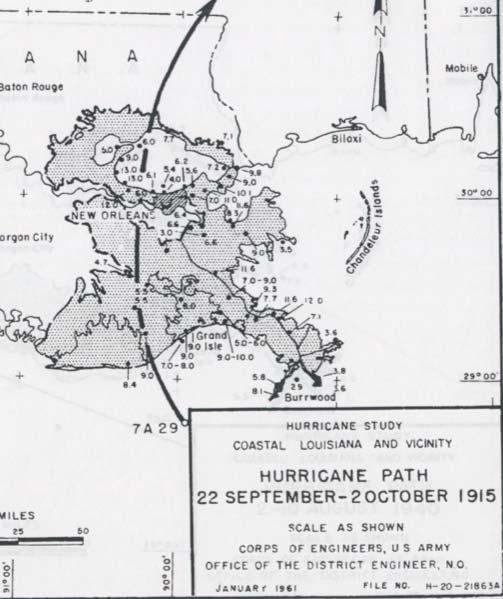
44 LP LP LP
45 LP LP wet side rainfall LP
46
47 ENE 45 SW 15
48 SSW to SE 25 SE 16 S 12 SW 15 SW 15 NNW 10 WNW 10

49 WSW 29 S 12

50 The future of the region and New Orleans hinges on Coastal restoration. Emergence of Coastal Louisiana s Vulnerability to Hurricane Surges Eye over lake but west of Orleans 21 deaths West passage 58 deaths Hurricane Betsy West Passage 12 deaths East Passage 986 to 1,440 deaths Hurricane Katrina Pontchartrain & Vic. Decision Chronology (Woolly and Shabman, 2008) Mortality added by LPBF 3
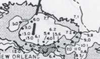
51 Lake Passage, such as 1915 Hurricane

52 E>W E>S>W E>N>W
53
54 So what is the worst track scenario for Pontchartrain Maurepas Surge? Different tracks put different areas at most risk
55 LP Westerly Passage E>S>W wind rotation worst case surge Frenier to Mandeville LP LP LP
56 Easterly Passage E>N>W wind rotation worst case surge NO east to Slidell LP LP LP LP


57 Lake Passage E>W wind shift worst case surge Frenier & Slidell


58 All worst case surges of the three conceptual tracks
59 Typical Expected Characteristics to the Pontchartrain Maurepas Basin Relative track Westward Passage of LP Eastward Passage of LP Central Passage LP Example storms tracks Isaac, Gustav, Bill, Betsy Katrina, Isidore, Camille, Georges 1915 hurricane? Wind field shift (origin) East>South>West East>North>West E>W Surge max rotation Clockwise Counter clockwise Symmetrical west to east Local Rainfall Wet storm Dry storm?? Local Runoff significant, may add to surge less significant?? Location Maximum lake surge NW quadrant NE Quadrant NE Quadrant Approaching "Slosh" location LaBranch/Frenier LaBranch/Frenier Frenier Departing "Slosh" Location NW Quadrant NE Quadrant NE Quadrant
60 Preliminary conclusions of Lake surge sloshing Primary Factors Surge flux, i.e. surge head Waves, i.e. run up Secondary Factors Shoreline geometry e.g. leeward/windward or convergence Natural Shoreline type e.g. shallow /steep, vegetation Surge transmission potential e.g. cross sectional area, roughness Levees, e.g. reducing storage, deflecting surge In all except a for direct strike, Sloshing is actually a rotation of maximum surge around the lake perimeter, but typically more pronounced on eastern and western shores. The rotation of the max surge is counter clockwise for an east passing storm and clockwise for a westerly passing storm. For Lake passage surge would likely slosh symmetrically west to east.
Hurricane Tracks. Isaac versus previous storms Impacts and solutions. ( Continue by clicking on the slide bar to the right)
") Hurricane Tracks Isaac versus previous storms Impacts and solutions ( Continue by clicking on the slide bar to the right) 1 Hurricane Tracks 2 Sample Hurricanes The sample hurricanes selected were chosen
Hurricane Tracks Isaac versus previous storms Impacts and solutions ( Continue by clicking on the slide bar to the right) 1 Hurricane Tracks 2 Sample Hurricanes The sample hurricanes selected were chosen
SLOSH New Orleans Basin 2012 Update
 SLOSH New Orleans Basin 2012 Update Michael Koziara Science and Operations Officer National Weather Service Slidell, LA The Basics What is storm surge? What is SLOSH? Details Assumptions Inundation = Storm
TROPICAL STORM NATE BRIEFING
 TROPICAL STORM NATE BRIEFING 10:30 AM CDT Friday, October 06, 2017 Prepared by: NWS NWSNewOrleans www.weather.gov/neworleans Situation Overview Track forecast has shifted slightly eastward. Hurricane Watch
Comparative Analysis of Hurricane Vulnerability in New Orleans and Baton Rouge. Dr. Marc Levitan LSU Hurricane Center. April 2003
 Comparative Analysis of Hurricane Vulnerability in New Orleans and Baton Rouge Dr. Marc Levitan LSU Hurricane Center April 2003 In order to compare hurricane vulnerability of facilities located in different
HURRICANE NATE BRIEFING
 HURRICANE NATE BRIEFING 2:00 PM CDT Saturday, October 07, 2017 Prepared by: NWS NWSNewOrleans www.weather.gov/neworleans Situation Overview continues to intensify. It is now forecast to be a category 2
Appendix A STORM SURGE AND WAVE HEIGHT ANALYSIS
 Appendix A STORM SURGE AND WAVE HEIGHT ANALYSIS Memo To: Jeff Robinson, P.E., GEC, Inc. From: Silong Lu, Ph.D., P.E., D.WRE, Dynamic Solutions, LLC. Date: 1/9/2014 CC: Re: Chris Wallen, Vice President,
CHAPTER SEVEN: THE NEW ORLEANS EAST PROTECTED AREA
 7.1 Introduction CHAPTER SEVEN: THE NEW ORLEANS EAST PROTECTED AREA The New Orleans East (NEO) protected area includes some of the lowest ground in the metropolitan region. Therefore, it is not surprising
TROPICAL STORM NATE BRIEFING
 TROPICAL STORM NATE BRIEFING 2:00 PM CDT Friday, October 06, 2017 Prepared by: NWS NWSNewOrleans www.weather.gov/neworleans Situation Overview Track forecast has not changed since the 10 am advisory. Hurricane
Tropical Weather Briefing
 Tropical Weather Briefing August 28, 2012 700 AM CDT National Weather Service Weather Forecast Office Slidell, LA Current Satellite Tropical Storm Isaac Watches/Warnings Tropical Storm Isaac Track Guidance
Mapping the River as it Reconnects with Its Delta: Field Studies in Big Mar and Bohemia
 Mapping the River as it Reconnects with Its Delta: Field Studies in Big Mar and Bohemia Ezra Boyd, John Lopez, Andy Baker, Theryn Henkel Lake Pontchartrain Basin Foundation Coastal Sustainability Program
US Army Corps of Engineers BUILDING STRONG
 Greater New Orleans Hurricane and Storm Damage Risk Reduction System Robert Rowlette Senior Senior Program Manager Task Force Hope U.S. Army Corps of Engineers April 19, 2012 US Army Corps of Engineers
Greater New Orleans Hurricane and Storm Damage Risk Reduction System 101
 Greater New Orleans Hurricane and Storm Damage Risk Reduction System 101 René Poché New Orleans District U.S. Army Corps of Engineers US Army Corps of Engineers BUILDING STRONG 1878 Gentilly Ridge Metairie
APPENDIX G-7 METEROLOGICAL DATA
 APPENDIX G-7 METEROLOGICAL DATA METEOROLOGICAL DATA FOR AIR AND NOISE SAMPLING DAYS AT MMR Monthly Normals and Extremes for Honolulu International Airport Table G7-1 MMR RAWS Station Hourly Data Tables
TROPICAL STORM NATE BRIEFING
 TROPICAL STORM NATE BRIEFING 5:00 AM CDT Friday, October 6, 2017 Prepared by: NWS NWSNewOrleans www.weather.gov/neworleans Situation Overview No significant changes to the track forecast this morning.
Coastal Emergency Risks Assessment - CERA Real-Time Storm Surge and Wave Visualization Tool
 Coastal Emergency Risks Assessment - CERA Real-Time Storm Surge and Wave Visualization Tool Introduction This document provides guidance for using the Coastal Emergency Risks Assessment (CERA) visualization
Modeling Nearshore Waves for Hurricane Katrina
 Modeling Nearshore Waves for Hurricane Katrina Jane McKee Smith US Army Engineer Research & Development Center Coastal and Hydraulics Laboratory Outline Introduction Modeling Approach Hurricane Katrina
The Climate of Payne County
 The Climate of Payne County Payne County is part of the Central Great Plains in the west, encompassing some of the best agricultural land in Oklahoma. Payne County is also part of the Crosstimbers in the
Construction complete on all HSDRRS projects across storm evacuation routes
 Task Force Hope Status Report August 29, 2013 Construction complete on all HSDRRS projects across storm evacuation routes Eastern Tie-In Swing Gates positioned across Hwy. 23 By Susan Spaht If a tropical
Wetland attenuation of Hurricane Rita s storm surge
 Wetland attenuation of Hurricane Rita s storm surge Pat Fitzpatrick, Yee Lau, Yongzuo Li, Nam Tran, Chris Hill, and Suzanne Shean Geosystems Research Institute, Mississippi State University Sponsors: NOAA
Hurricane Isaac. National Weather Service. Communication Challenges and The Future. Weather Forecast Office New Orleans/Baton Rouge
 Hurricane Isaac Communication Challenges and The Future National Weather Service Weather Forecast Office New Orleans/Baton Rouge Hurricane Isaac Challenges 2012 Tropical Season Season was quiet for Louisiana
OSCILLATIONS OF SEMI-ENCLOSED WATER BODY INDUCED BY HURRICANES. Yuan-Hung Paul Tan 1 and Jiin-Jen Lee 1
 OSCILLATIONS OF SEMI-ENCLOSED WATER BODY INDUCED BY HURRICANES Yuan-Hung Paul Tan 1 and Jiin-Jen Lee 1 The primary focus of this research is to study the oscillations of semi-enclosed water body induced
Chapter 16, Part Hurricane Paths. 2. Hurricane Paths. Hurricane Paths and Damage
 Chapter 16, Part 2 Hurricane Paths and Damage 1. Hurricane Paths Start over tropical water except South Atlantic and eastern South Atlantic, where water is too cold. Initially steered by easterly winds
LOCAL CLIMATOLOGICAL DATA Monthly Summary November 2006
 Deg. Days Precip Ty Precip Wind Sun Hu- Adj. to Sea Level mid- ity Avg Res Res Peak Minute 1 fog 2 hvy fog 3 thunder 4 ice plt 5 hail 6 glaze 7 duststm 8 smk, hz 9 blw snw 1 2 3 4A 4B 5 6 7 8 9 12 14 15
The Climate of Marshall County
 The Climate of Marshall County Marshall County is part of the Crosstimbers. This region is a transition region from the Central Great Plains to the more irregular terrain of southeastern Oklahoma. Average
Agricultural Outlook Forum Presented: February 17, 2006 THE SCIENCE BEHIND THE ATLANTIC HURRICANES AND SEASONAL PREDICTIONS
 Agricultural Outlook Forum Presented: February 17, 2006 THE SCIENCE BEHIND THE ATLANTIC HURRICANES AND SEASONAL PREDICTIONS Gerald Bell Meteorologist, National Centers for Environmental Prediction NOAA,
LOCAL CLIMATOLOGICAL DATA Monthly Summary July 2013
 Deg. Days Precip Ty Precip Wind Solar Hu- Adj. to Sea Level mid- ity Avg Res Res Peak Minute 1 fog 2 hvy fog 3 thunder 4 ice plt 5 hail 6 glaze 7 duststm 8 smk, hz 9 blw snw 1 2 3 4A 4B 5 6 7 8 9 12 14
Donna J. Kain, PhD and Catherine F. Smith, PhD East Carolina University
 Risk Perceptions and Emergency Communication Effectiveness in Coastal Zones Preliminary Findings on Interpretations of Weather Related Messages and Maps Donna J. Kain, PhD (kaind@ecu.edu), and Catherine
HURRICANE ISAAC WITH AND WITHOUT YEAR HSDRRS EVALUATION
 HURRICANE ISAAC WITH AND WITHOUT 2012 100-YEAR HSDRRS EVALUATION FINAL REPORT FEBRUARY 2013 Executive Summary EXECUTIVE SUMMARY SIGNIFICANT FINDINGS According to the Saffir-Simpson Hurricane Wind Scale,
LOCAL CLIMATOLOGICAL DATA Monthly Summary September 2016
 Deg. Days Precip Ty Precip Wind Solar Hu- Adj. to Sea Level mid- ity Avg Res Res Peak 2 Minute 1 fog 2 hvy fog 3 thunder 4 ice plt 5 hail 6 glaze 7 duststm 8 smk, hz 9 blw snw 1 2 3 4A 4B 5 6 7 8 9 11
The Climate of Seminole County
 The Climate of Seminole County Seminole County is part of the Crosstimbers. This region is a transition region from the Central Great Plains to the more irregular terrain of southeastern Oklahoma. Average
WEATHER SYSTEMS IMPACTING THE CAYMAN ISLANDS Prepared by the staff of the Cayman Islands National Weather Service
 WEATHER SYSTEMS IMPACTING THE CAYMAN ISLANDS 2008 Prepared by the staff of the Cayman Islands National Weather Service TROPICAL STORM DOLLY Formed 194 miles west of Grand Cayman July 19 th. The tropical
The Climate of Murray County
 The Climate of Murray County Murray County is part of the Crosstimbers. This region is a transition between prairies and the mountains of southeastern Oklahoma. Average annual precipitation ranges from
(April 7, 2010, Wednesday) Tropical Storms & Hurricanes Part 2
 Tropical Storms & Hurricanes Part 2") Lecture #17 (April 7, 2010, Wednesday) Tropical Storms & Hurricanes Part 2 Hurricane Katrina August 2005 All tropical cyclone tracks (1945-2006). Hurricane Formation While moving westward, tropical disturbances
Lecture #17 (April 7, 2010, Wednesday) Tropical Storms & Hurricanes Part 2 Hurricane Katrina August 2005 All tropical cyclone tracks (1945-2006). Hurricane Formation While moving westward, tropical disturbances
Storm Surge Forecast with Shifting Forecast Tracks
 Storm Surge Forecast with Shifting Forecast Tracks Storm Surge Findings in the Florida Keys Jon Rizzo Warning Coordination Meteorologist National Weather Service Florida Keys Florida Keys Life History
Hurricanes and Storm Surge : Before coming to lab, visit the following web site:
 Geol 108 Lab #7 Week of October 15-19, 2012 Coastal Studies Hurricanes and Storm Surge : Before coming to lab, visit the following web site: http://www.usatoday.com/graphics/weather/gra/gsurge/flash.htm
Chapter 24. Tropical Cyclones. Tropical Cyclone Classification 4/19/17
 Chapter 24 Tropical Cyclones Tropical Cyclones Most destructive storms on the planet Originate over tropical waters, but their paths often take them over land and into midlatitudes Names Hurricane (Atlantic
Format of CLIGEN weather station statistics input files. for CLIGEN versions as of 6/2001 (D.C. Flanagan).
.") Format of CLIGEN weather station statistics input files for CLIGEN versions 4.1-5.1 as of 6/2001 (D.C. Flanagan). updated 12/11/2008 - Jim Frankenberger These files are also known as CLIGEN state files
Format of CLIGEN weather station statistics input files for CLIGEN versions 4.1-5.1 as of 6/2001 (D.C. Flanagan). updated 12/11/2008 - Jim Frankenberger These files are also known as CLIGEN state files
The Climate of Haskell County
 The Climate of Haskell County Haskell County is part of the Hardwood Forest. The Hardwood Forest is characterized by its irregular landscape and the largest lake in Oklahoma, Lake Eufaula. Average annual
LECTURE #18: Hurricane Damage, Monitoring & Case Study
 GEOL 0820 Ramsey Natural Disasters Spring, 2018 LECTURE #18: Hurricane Damage, Monitoring & Case Study Date: 27 March 2018 I. Exam II grades now posted online o high: 98, low: 46, average: 80 (~3 points
Hurricanes. April 14, 2009
 Tropical Weather & Hurricanes Chapter 15 April 14, 2009 Tropical meteorology Tropics characterized by seasonal wet and drier periods- wet when sun is nearly overhead at noon and inter-tropical convergence
Lab 12 Coastal Geology
 Lab 12 Coastal Geology I. Fluvial Systems Hydrologic Cycle Runoff that flows into rivers = precipitation (rain and snowmelt) [infiltration (loss to groundwater) + evaporation (loss to atmosphere) + transpiration
Loss Avoidance Study. St. Tammany Parish, Louisiana Hurricane Isaac, 2012 DR-4080-LA. Joint Field Office, Hazard Mitigation Branch, Baton Rouge, LA
 Loss Avoidance Study St. Tammany Parish, Louisiana Hurricane Isaac, 2012 DR-4080-LA Joint Field Office, Hazard Mitigation Branch, Baton Rouge, LA January 2013 Hurricane Isaac, August 2012 Losses Avoided
The Climate of Kiowa County
 The Climate of Kiowa County Kiowa County is part of the Central Great Plains, encompassing some of the best agricultural land in Oklahoma. Average annual precipitation ranges from about 24 inches in northwestern
Hurricane Katrina and Oil Spills: Impact on Coastal and Ocean Environments
 Archived version from NCDOCKS Institutional Repository http://libres.uncg.edu/ir/asu/ Pine, J. C. (June 2006). Hurricane Katrina and oil spills: Impact on coastal and ocean environments. Oceanography,
The Climate of Bryan County
 The Climate of Bryan County Bryan County is part of the Crosstimbers throughout most of the county. The extreme eastern portions of Bryan County are part of the Cypress Swamp and Forest. Average annual
Draft for Discussion 11/11/2016
 Coastal Risk Consulting (CRC) Climate Vulnerability Assessment for Village of Key Biscayne Deliverable 1.1 in Statement of Work. Preliminary Vulnerability Assessment Identifying Flood Hotspots Introduction...
UPDATE OF REGIONAL WEATHER AND SMOKE HAZE (December 2017)
") UPDATE OF REGIONAL WEATHER AND SMOKE HAZE (December 2017) 1. Review of Regional Weather Conditions for November 2017 1.1 In November 2017, Southeast Asia experienced inter-monsoon conditions in the first
UPDATE OF REGIONAL WEATHER AND SMOKE HAZE (December 2017) 1. Review of Regional Weather Conditions for November 2017 1.1 In November 2017, Southeast Asia experienced inter-monsoon conditions in the first
Frank Revitte National Weather Service. Weather Forecast Office New Orleans/Baton Rouge
 Frank Revitte National Weather Service Weather Forecast Office New Orleans/Baton Rouge Above normal activity 17 Total Named Storms 7 Tropical Storms 4 Hurricanes 6 Major Hurricanes Not the most active,
2013 Louisiana Transportation Conference
 2013 Louisiana Transportation Conference Background FHWA/AASHTO study Objectives of LADOTD study Level III methodology Surge/Wave force methodology 100-Year Surge-Wave GIS Atlas Summary Questions Pensacola,
Coastal Litigation in the Context of Science Literacy
 Coastal Litigation in the Context of Science Literacy Chris McLindon New Orleans Geological Society February 6, 7 Science Literacy The value of community participation in scientific research is widely
The Climate of Texas County
 The Climate of Texas County Texas County is part of the Western High Plains in the north and west and the Southwestern Tablelands in the east. The Western High Plains are characterized by abundant cropland
Cause, Assessment & Management of Flood Hazards associated with Landfalling Tropical Cyclones & Heavy Rain
 Cause, Assessment & Management of Flood Hazards associated with Landfalling Tropical Cyclones & Heavy Rain by CHEN Charng Ning, Professor Emeritus Nanyang Technological University (NTU), Singapore Consultant,
Typhoon Maemi and Hurricane Katrina: Impacts and Aftermath. Typhoon Maemi: September 13, Typhoon Maemi Track and Characteristics
 Typhoon Maemi and Hurricane Katrina: Impacts and Aftermath Pierre Julien Un Ji Department of Civil Engineering Colorado State University Fort Collins, Colorado USA September, 2005 Typhoon Maemi: September
Report on the Damage Survey Caused by Hurricane Katrina (Tentative Report)
") Report on the Damage Survey Caused by Hurricane Katrina (Tentative Report) November 1, 2005 Coastal Disaster Prevention Technology Survey Team 1. Introduction Hurricane Katrina struck the United States
Report on the Damage Survey Caused by Hurricane Katrina (Tentative Report) November 1, 2005 Coastal Disaster Prevention Technology Survey Team 1. Introduction Hurricane Katrina struck the United States
HURRICANE IRMA. 12 PM ET Saturday, September Prepared by: Kyle Thiem / Sid King.
 HURRICANE IRMA 12 PM ET Saturday, September 9 2017 Prepared by: Kyle Thiem / Sid King www.weather.gov/atlanta/briefings @NWSAtlanta www.weather.gov/atlanta Situation Overview 11:00 AM EDT Sat Sep 9 Location:
Florida Statewide Regional Evacuation Study Program
 Florida Statewide Regional Evacuation Study Program Directional Atlas Lafayette County Volume 10-3 Book 4 Florida Division of Emergency Management North Central Florida Regional Planning Council North
Drought Impacts in the Southern Great Plains. Mark Shafer University of Oklahoma Norman, OK
 Drought Impacts in the Southern Great Plains Mark Shafer University of Oklahoma Norman, OK Causes of Drought: Large-Scale, Stationary High Pressure Air rotates clockwise around high pressure steers storms
CLIMATE READY BOSTON. Climate Projections Consensus ADAPTED FROM THE BOSTON RESEARCH ADVISORY GROUP REPORT MAY 2016
 CLIMATE READY BOSTON Sasaki Steering Committee Meeting, March 28 nd, 2016 Climate Projections Consensus ADAPTED FROM THE BOSTON RESEARCH ADVISORY GROUP REPORT MAY 2016 WHAT S IN STORE FOR BOSTON S CLIMATE?
Ch. 3: Weather Patterns
 Ch. 3: Weather Patterns Sect. 1: Air Mass & Fronts Sect. 2: Storms Sect. 3: Predicting the Weather Sect. 4: Weather forecasters use advanced technologies Ch. 3 Weather Fronts and Storms Objective(s) 7.E.1.3
Monitoring Hurricane Rita Inland Storm Surge
 Monitoring Hurricane Rita Inland Storm Surge By Benton D. McGee, Roland W. Tollett, and Burl B. Goree Pressure transducers (sensors) are accurate, reliable, and cost-effective tools to measure and record
SAMPLE. SITE SPECIFIC WEATHER ANALYSIS Wind Report. Robinson, Smith & Walsh. John Smith. July 1, 2017 REFERENCE: 1 Maple Street, Houston, TX 77034
 SAMPLE SITE SPECIFIC WEATHER ANALYSIS Wind Report PREPARED FOR: Robinson, Smith & Walsh John Smith July 1, 2017 REFERENCE: JACK HIGGINS / 4151559-01 1 Maple Street, Houston, TX 77034 CompuWeather Sample
30 If Vmax > 150, HSI intensity pts = 25
 Hurricane Severity Index: A New Way of Estimating a Tropical Cyclone s Destructive Potential 1. Introduction Christopher G. Hebert*, Robert A. Weinzapfel*, Mark A. Chambers* Impactweather, Inc., Houston,
Florida Statewide Regional Evacuation Study Program
 Florida Statewide Regional Evacuation Study Program Directional Atlas Brevard County Volume 10-6 Book 1 Florida Division of Emergency Management East Central Florida Regional Planning Council East Central
The Climate of Grady County
 The Climate of Grady County Grady County is part of the Central Great Plains, encompassing some of the best agricultural land in Oklahoma. Average annual precipitation ranges from about 33 inches in northern
Trends in the Character of Hurricanes and their Impact on Heavy Rainfall across the Carolinas
 Trends in the Character of Hurricanes and their Impact on Heavy Rainfall across the Carolinas Chip Konrad Carolina Integrated Science and Assessments (CISA) The Southeast Regional Climate Center Department
Hurricane KATRINA Lessons Learned for Managing Risk
 Hurricane KATRINA Lessons Learned for Managing Risk Steven L. Stockton, P.E. Deputy Director of Civil Works U.S. Army Corps of Engineers What Happened? Storm Path from August 23 to 31, 2005 Mon. August
Hurricane Matthew Threats and Impacts Briefing for Eastern NC
 Hurricane Matthew Threats and Impacts Briefing for Eastern NC October 6 th, 2016 Date/Time Created: 10/6/2016, Noon EDT National Weather Service Newport/Morehead City, NC Hurricane Matthew Key Points Changes
The Climate of Pontotoc County
 The Climate of Pontotoc County Pontotoc County is part of the Crosstimbers. This region is a transition region from the Central Great Plains to the more irregular terrain of southeast Oklahoma. Average
An Integrated Storm Surge, Hurricane Wave, Salinity and Sediment Transport Modeling System for Breton Sound, LA
 An Integrated Storm Surge, Hurricane Wave, Salinity and Sediment Transport Modeling System for Breton Sound, LA Q. Jim Chen Department of Civil and Environmental Engineering qchen@lsu.edu Acknowledgements
SAMPLE. SITE SPECIFIC WEATHER ANALYSIS Wind Report. Robinson, Smith & Walsh. John Smith REFERENCE:
 SAMPLE SITE SPECIFIC WEATHER ANALYSIS Wind Report PREPARED FOR: Robinson, Smith & Walsh John Smith REFERENCE: JACK HIGGINS / 4151559-01 CompuWeather Sample Report Please note that this report contains
What s s New for 2009
 What s s New for 2009 Graphical Tropical Weather Outlook becomes operational Special Tropical Disturbance Statement replaced with Special Tropical Weather Outlook Tropical Cyclone Wind Field Graphic becomes
Local Storm Surge Considerations. Al Sandrik Warning Coordination Meteorologist National Weather Service Office Jacksonville, Florida
 Local Storm Surge Considerations Al Sandrik Warning Coordination Meteorologist National Weather Service Office Jacksonville, Florida SLOSH Display Program Some Definitions: Astronomical Tide: The daily
THE IMPORTANCE OF SCIENCE IN COASTAL RESTORATION IN LOUISIANA
 THE IMPORTANCE OF SCIENCE IN COASTAL RESTORATION IN LOUISIANA Barb Kleiss USACE, Mississippi Valley Division August 3, 2011 LCA S&T Office Authorized under WRDA 2007 Designed to address technical issues
1. Sea Surface Temperatures (SSTs) > 27 and extending to some depth.
 > 27 and extending to some depth.") Formation Factors for Hurricanes 1. Sea Surface Temperatures (SSTs) > 27 and extending to some depth. 2. Location >5 away from the equator (usually 10 ). Coriolis force is necessary for rotation. 3. High
Formation Factors for Hurricanes 1. Sea Surface Temperatures (SSTs) > 27 and extending to some depth. 2. Location >5 away from the equator (usually 10 ). Coriolis force is necessary for rotation. 3. High
MODELLING CATASTROPHIC COASTAL FLOOD RISKS AROUND THE WORLD
 MODELLING CATASTROPHIC COASTAL FLOOD RISKS AROUND THE WORLD Nicola Howe Christopher Thomas Copyright 2016 Risk Management Solutions, Inc. All Rights Reserved. June 27, 2016 1 OUTLINE MOTIVATION What we
LMRFC is one of 13 NWS RFCs. There are 4 RFCs within the Southern Region of the NWS. Southern Region HQ is located in Fort Worth, TX
 LMRFC is one of 13 NWS RFCs There are 4 RFCs within the Southern Region of the NWS. Southern Region HQ is located in Fort Worth, TX The LMRFC hydrologic forecasting program provides hydrologic guidance
Simulation of storm surge and overland flows using geographical information system applications
 Coastal Processes 97 Simulation of storm surge and overland flows using geographical information system applications S. Aliabadi, M. Akbar & R. Patel Northrop Grumman Center for High Performance Computing
SOUTHERN CLIMATE MONITOR
 SOUTHERN CLIMATE MONITOR MARCH 2011 VOLUME 1, ISSUE 3 IN THIS ISSUE: Page 2 to 4 Severe Thunderstorm Climatology in the SCIPP Region Page 4 Drought Update Page 5 Southern U.S. Precipitation Summary for
Custom Weather Forecast
 1 of 23 Custom Weather Forecast 2018 Chicago Yacht Club s Race To Mackinac- Cruising Division Disclaimer: The user assumes all risk related to the use of this Custom Weather Forecast. The crew of the participating
General background on storm surge. Pat Fitzpatrick and Yee Lau Mississippi State University
 General background on storm surge Pat Fitzpatrick and Yee Lau Mississippi State University Storm surge is an abnormal rise of water associated with a cyclone, not including tidal influences Low pressure
Regional Sediment Management
 Regional Sediment Management Linda S. Lillycrop Program Manager Coastal Engineer US Army Engineer Research and Development Center Coastal and Hydraulics Laboratory Q AVG Coastal Resilience: The Environmental,
CHAPTER FIVE: THE LOWER MISSISSIPPI REGION AND PLAQUEMINES PARISH
 CHAPTER FIVE: THE LOWER MISSISSIPPI REGION AND PLAQUEMINES PARISH 5.1 Overview Plaquemines Parish is the area where the last portion of the Mississippi River flows out into the Gulf of Mexico (see Figures
Tropical Update. 5 PM EDT Thursday, September 7, 2017 Hurricane Irma, Hurricane Jose, and Hurricane Katia
 Tropical Update 5 PM EDT Thursday, September 7, 2017 Hurricane Irma, Hurricane Jose, and Hurricane Katia This update is intended for government and emergency response officials, and is provided for informational
COASTAL DATA APPLICATION
 2015 Coastal GeoTools Proactive By Design. Our Company Commitment COASTAL DATA APPLICATION Projecting Future Coastal Flood Risk for Massachusetts Bay Bin Wang, Tianyi Liu, Daniel Stapleton & Michael Mobile
KCC White Paper: The 100 Year Hurricane. Could it happen this year? Are insurers prepared? KAREN CLARK & COMPANY. June 2014
 KAREN CLARK & COMPANY KCC White Paper: The 100 Year Hurricane Could it happen this year? Are insurers prepared? June 2014 Copyright 2014 Karen Clark & Company The 100 Year Hurricane Page 1 2 COPLEY PLACE
Storm Surge Frequency Analysis using a Modified Joint Probability Method with Optimal Sampling (JPM-OS)
") Storm Surge Frequency Analysis using a Modified Joint Probability Method with Optimal Sampling (JPM-OS) Jay Ratcliff Coastal Hydraulics Lab, of Engineers (USACE) Engineering Research and Development Center
Storm Surge Frequency Analysis using a Modified Joint Probability Method with Optimal Sampling (JPM-OS) Jay Ratcliff Coastal Hydraulics Lab, of Engineers (USACE) Engineering Research and Development Center
Exploring the costs of sea level rise: should we focus on means or extremes?
 Exploring the costs of sea level rise: should we focus on means or extremes? Robert Muir-Wood Chief Research Officer, RMS AAAS Chicago Feb 16 th 2009 Change Points in Cat 3-5 Hurricane Numbers (the drivers
Hurricane Surge Hazard Analysis for Southeast Louisiana
 Hurricane Surge Hazard Analysis for Southeast Louisiana SLFPA-E Coastal Advisory Committee and Invitees February 21, 2013 Presented by Bob Jacobsen PE, LLC Consulting Coastal Hydrologist Objective Review
Ellen L. Mecray NOAA Regional Climate Services Director, Eastern Region Taunton, MA
 Ellen L. Mecray NOAA Regional Climate Services Director, Eastern Region Taunton, MA Regions of the US National Climate Assessment What we Observe: Climate changes and impacts Increasing temperature Increasingly
WEDNESDAY 30 TH AUGUST, :57 p.m. Tropical Storm Irma forms in the Atlantic. Don t let your guard down, always #Be Ready.
 Chapter 1 - The Set Up In the days leading up to Irma a series of composed and sobering text messages, presented in truncated form below, from Department of Disaster Management warned us of the pending
Climate and the Atmosphere
 Climate and Biomes Climate Objectives: Understand how weather is affected by: 1. Variations in the amount of incoming solar radiation 2. The earth s annual path around the sun 3. The earth s daily rotation
Visualizing hurricanes
 Visualizing hurricanes NAME: DATE: Scientific visualization is an integral part of the process of simulating natural phenomena. In the computational sciences, the main goal is to understand the workings
Hurricane Matthew. National Weather Service Wilmington NC. Steven Pfaff, WCM.
 Hurricane Matthew Threat Assessment for northeast South Carolina & southeast North Carolina National Weather Service Wilmington NC 515 PM EDT Monday October 3, 2016 Steven Pfaff, WCM Steven.Pfaff@noaa.gov
Smart Flood Risk Management Solutions
 Smart Flood Risk Management Solutions - RHDHV s Experience in the Gulf of Mexico Mathijs van Ledden, Marten Hillen and Ries Kluskens Challenge Extreme weather around the world (hurricanes, cyclones, extratropical
TROPICAL STORM HARVEY BRIEFING
 TROPICAL STORM HARVEY BRIEFING 10:00 AM CDT Sunday, August 27, 2017 Prepared by: NWS LIX NWSNewOrleans www.weather.gov/neworleans Situation Overview New Information Tropical Storm Winds 40mph Immediate
CERA-Atlantic Storm Surge Web Page: Improvements for 2013 Based on EM Feedback
 CERA-Atlantic Storm Surge Web Page: Improvements for 2013 Based on EM Feedback Jessica Losego Meteorologist University of North Carolina - Institute for the Environment Rick Luettich Director, UNC IMS
East Penn School District Curriculum and Instruction
 East Penn School District Curriculum and Instruction Curriculum for: Meteorology Course(s): Meteorology Grades: 10-12 Department: Science Length of Period (average minutes): 42 Periods per cycle: 6 Length
Heavy Rainfall Event of June 2013
 Heavy Rainfall Event of 10-11 June 2013 By Richard H. Grumm National Weather Service State College, PA 1. Overview A 500 hpa short-wave moved over the eastern United States (Fig. 1) brought a surge of
HURRICANE HARVEY COE Navigation BRIEFING
 HURRICANE HARVEY COE Navigation BRIEFING 10:00 AM CDT Friday, August 25, 2017 NWSNewOrleans www.weather.gov/neworleans Situation Overview New Information Harvey continues to strengthen Max sustained winds