Historical Bathymetric Data for the Lower Passaic River
|
|
|
- Silvia Henderson
- 6 years ago
- Views:
Transcription
1 Historical Bathymetric Data for the Lower Passaic River 4th Passaic River Symposium June 22nd, 2010 Dr. William Hansen Jeffrey Cranson Worcester State College Project Supported by The Hudson River Foundation for Science and Environmental Research
2 Outline of Presentation Lower Passaic River Study Area. Historical Hydrographic Data. Processing and Rectifying data Interpolation Procedure Bathymetric Surfaces and Differences Conclusion
3
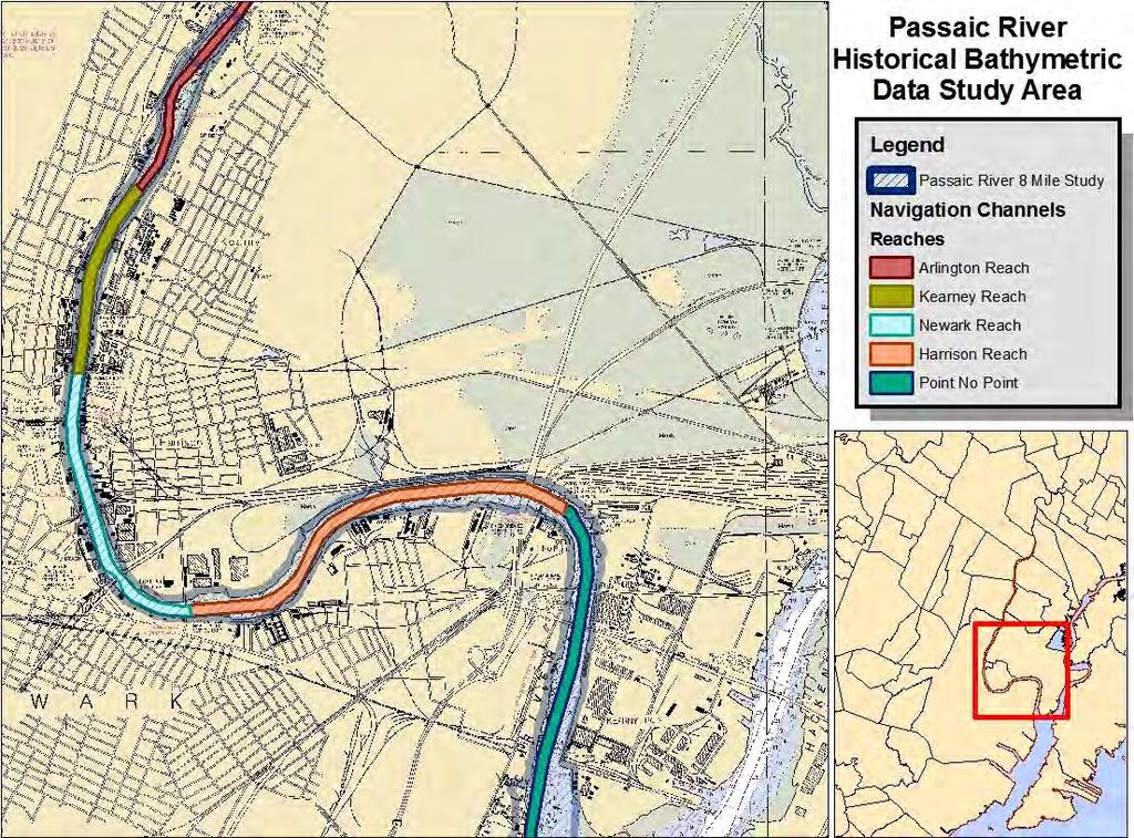
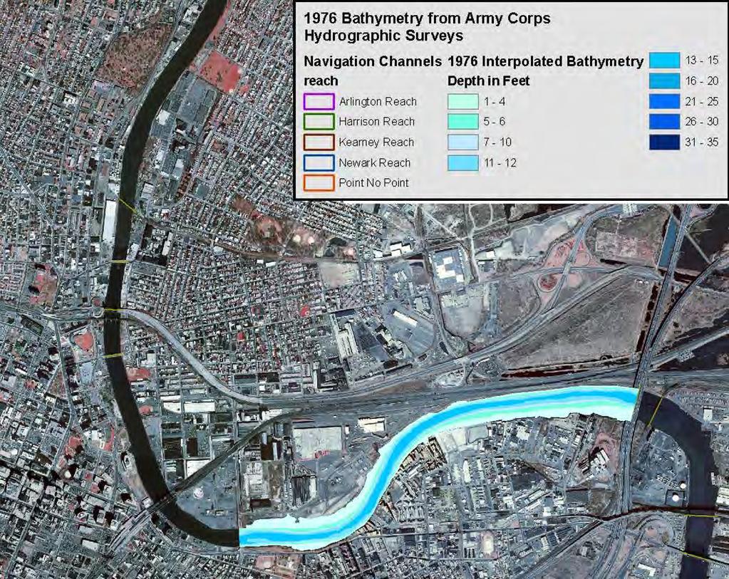
4 Dredging History Arlington Reach 200 feet wide channel 16 feet authorized depth. Last Dredged in 1930 (Iannuzzi, et al. 2002) Newark and Kearney Reaches 300 feet wide channel. 20 feet authorized depth, historically maintained at 16 feet. Last Dredged in 1950 (Iannuzzi, et al. 2002) Harrison Reach 300 feet channel, 20 feet authorized depth, maintained at 16 feet. Last dredged Point No Point Reach 300 feet channel,30 feet authorized, 30 maintained depth. Dredged 1946, 1951, 1957, 1962, 1965, 1971, 1972, 1977, (Iannuzzi, et al. 2002)

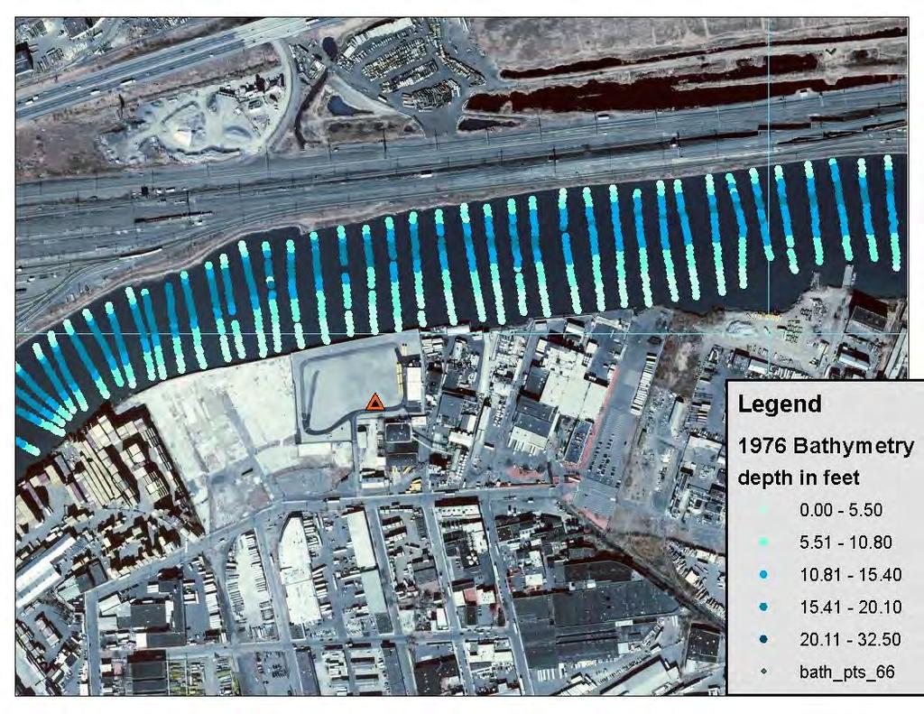
5 Historical Bathymetry Data Current hydrographic surveys are done digitally. Started in 1999 for Passaic River Historical Bathymetry on microfiche in District Office. Time periods available were: 1949, 1952, 1966, 1973 and None of the surveys had complete coverage of the study area.


6 Historical Bathymetry Data Scanned jpeg files of US Army Corps of Engineers Hydrographic Survey sheets on Microfiche were obtained from NY District through a FOIA request.


7 Base map Data 2007 Digital Bathymetry data was provided by the Army Corps in CAD format. Channels were extracted and used in rectification procedure. Digital OrthoPhotos downloaded from State of New Jersey


8 Historical Bathymetry Data Scanned Surveys were rectified to NJDEP high resolution Digital Ortho photos and Digital Channel data.

9
10 Digitizing Procedure Hydrographic Survey point locations and depth values were digitized into GIS point shapefiles using ArcGIS 9.3. New Jersey State Plane coordinates Fields - Depth and Depth with tidal datum change Check plots were created, values displayed by graduated color and labeled. Survey depths were adjusted for tidal datum change since 1900.
11

12 Tidal Datum Change Based on NOAA Tidal Station The Battery, NY Baseline 1900 Mean Sea Level 1.54 Feet April 19-22, 1949 Mean Sea Level (MSL) 2.13 feet Difference ft. April 21 26, 1966 MSL 2.29 ft. Difference 0.75 ft. April 18-24, 1976 MSL 2.25 ft. Difference 0.71 ft. Nov-Dec ft. Difference 0.89 ft.

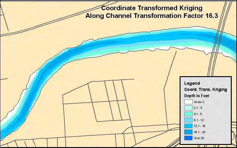
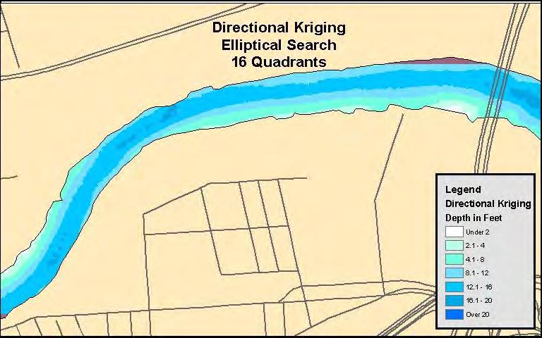
13 Interpolation Process of taking random sample point locations and values and mathematically calculating values at regular grid cells. Spline interpolator fits a minimum-curvature surface through the points. Best for gently varying surfaces such as elevation, water table heights, or pollution concentrations. Inverse Distance Weighting uses n number of neighboring points and weights the value of each point by its distance to the cell being analyzed and averages the values. Kriging uses a Semivariograms (measure the strength of statistical correlation as a function of distance.) to associate some probability with each prediction. Interpolation methods, including kriging, for this highly anisotropic dataset yielded poor results.
 and cross channel distances (X), therefore straightening the")
14 Data Transformation Spatial Locations were transformed to along channel distances (Y) and cross channel distances (X), therefore straightening the river.


15 Transformation
16

17
18
19
20

21
22

23
24

25 Depth in Feet Upstream New Jersey Turnpike South Bank Cross Channel Distance in Feet North Bank

26 Diamond Alkali Site Cross Sections Depth in Feet South Bank Cross Channel Distance in Feet North Bank

27 River Bank Park Depth in Feet South Bank Cross Channel Distance in Feet North Bank

28 Downtown Newark Depth in Feet South Bank Cross Channel Distance in Feet North Bank
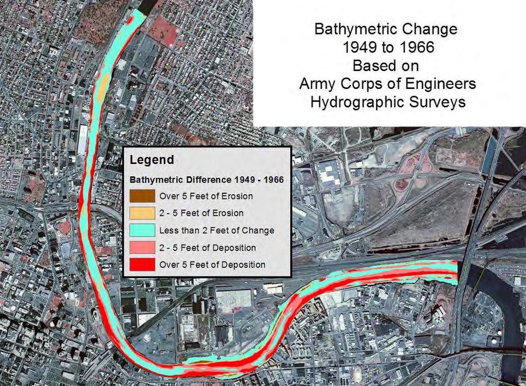
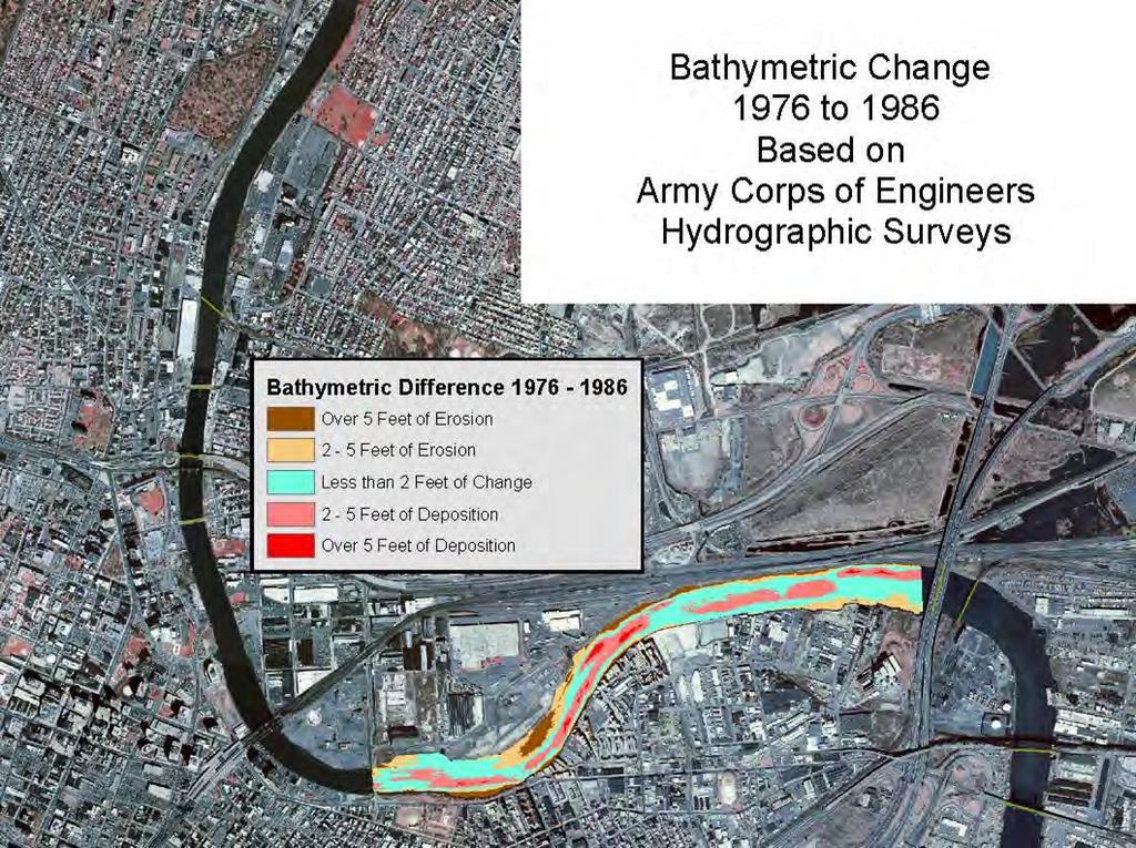
29 Conclusion Significant deposition has occurred in channel in the Lower Passaic. Major deposition between 1949 and Highest sedimentation rates along inner bend of navigation channel. Up to 9 feet in Harrison Reach. Timeframe of largely unregulated discharge Significant deposition and reworking of the thalweg between 1966 and Deposition highest at lower end of Harrison Reach. Erosion and deposition between 1976 and 1986 In channel deposition Significant areas of off-channel erosion
MaxDepth Aquatics, Inc.
 MaxDepth Aquatics, Inc. Bathymetry of Mirror Pond From Newport Bridge to Galveston Bridge Prepared for the City of Bend By Joseph Eilers & Benn Eilers MaxDepth Aquatics, Inc. Bend, OR June 2005 INTRODUCTION
Creating a Bathymetric Database & Datum Conversion
 Creating a Bathymetric Database & Datum Conversion Mitchell Brown Civil Engineering Technician Mitchell.E.Brown@erdc.dren.mil June 11, 2012 US Army Corps of Engineers BUILDING STRONG Introduction to Bathymetric
Colorado River: Mile 8 to Mile 13.5
 Colorado River: Mile to Mile. +00 +00 +00 0+00 0+00 +00 00+00 +00 +00 +00 +00 +00 +00 +00 +00 +00 +00 0+00 +00 +00 +00 +00 +00 0+00 +00 +00 0+00 +00 +00 +00 +00 0+00 +00 +00 +00 +00 +00 +00 +00 0+00 0+00
REGIONAL SEDIMENT MANAGEMENT: A GIS APPROACH TO SPATIAL DATA ANALYSIS. Lynn Copeland Hardegree, Jennifer M. Wozencraft 1, Rose Dopsovic 2 INTRODUCTION
 REGIONAL SEDIMENT MANAGEMENT: A GIS APPROACH TO SPATIAL DATA ANALYSIS Lynn Copeland Hardegree, Jennifer M. Wozencraft 1, Rose Dopsovic 2 ABSTRACT: Regional sediment management (RSM) requires the capability
Development and application of demonstration MIKE 21C morphological model for a bend in Mekong River
 Development and application of demonstration MIKE 21C morphological model for a bend in Mekong River September 2015 0 Table of Contents 1. Introduction... 2 2. Data collection... 3 2.1 Additional data...
Appendix I. Dredged Volume Estimates. Draft Contractor Document: Subject to Continuing Agency Review
 Appendix I Dredged Volume Estimates Draft Contractor Document: Subject to Continuing Agency Review Interoffice Correspondence Date: April 6, 2007 To: L. Bossi (WHI) Copy: S. Thompson (WHI), B. Fidler (NNJ)
Highland Lake Bathymetric Survey
 Highland Lake Bathymetric Survey Final Report, Prepared For: The Town of Highland Lake 612 Lakeshore Drive Oneonta, AL 35121 Prepared By: Tetra Tech 2110 Powers Ferry Road SE Suite 202 Atlanta, GA 30339
An Update to EPA s Conceptual Site Model for the Lower Passaic River: An Examination of the Most Recent Results
 An Update to EPA s Conceptual Site Model for the ower Passaic River: An Examination of the Most Recent Results Edward A. arvey, Alice Yeh 2, Solomon bondo-tugbawa, Juliana Atmadja, John Kern 3, AmyMarie
Kaskaskia Morphology Study Headwaters to Lake Shelbyville
 Kaskaskia Morphology Study Headwaters to Lake Shelbyville KWA Mini Summit 5 March 2012 1 Kaskaskia Morphology Study Headwaters to Lake Shelbyville Conducted by U.S. Army Corps of Engineers, St. Louis District
A Temporal Hydrologic Database for Rapidly Changing Landscapes
 A Temporal Hydrologic Database for Rapidly Changing Landscapes Using Mt. St. Helens in Washington as a Pilot Site Adam Mosbrucker Geog 575 BACKGROUND: Client / User U.S. Geological Survey Cascades Volcano
AN ASSESSMENT OF THE IMPACT OF RETENTION PONDS
 AN ASSESSMENT OF THE IMPACT OF RETENTION PONDS FOR SEDIMENT TRAPPING IN THE ADA CREEK AND LONGWOOD COVE USING REMOTELY SENSED DATA AND GIS ANALYSIS Sudhanshu Sekhar Panda Associate Professor, GIS/Env.
Mississippi River (Pool 2) 2-D ADH Model Development
 2-D ADH Model Development") Appendix E: Mississippi River (Pool 2) 2-D ADH Model Development (PREPARED BY WEST CONSULTANTS, 2011) Lower Pool 2 Channel Management Study: Boulanger Bend to Lock and Dam No. 2 US Army Corps of Engineers
Appendix E: Mississippi River (Pool 2) 2-D ADH Model Development (PREPARED BY WEST CONSULTANTS, 2011) Lower Pool 2 Channel Management Study: Boulanger Bend to Lock and Dam No. 2 US Army Corps of Engineers
FUTURE MEANDER BEND MIGRATION AND FLOODPLAIN DEVELOPMENT PATTERNS NEAR RIVER MILES 200 TO 191 OF THE SACRAMENTO RIVER PHASE III REPORT
 FUTURE MEANDER BEND MIGRATION AND FLOODPLAIN DEVELOPMENT PATTERNS NEAR RIVER MILES 200 TO 191 OF THE SACRAMENTO RIVER PHASE III REPORT Eric W. Larsen REPORT FOR DUCKS UNLIMITED March 31, 2006-1 - Contents
Hydrographic Survey Program Texas Water Development Board. Nathan Leber Holly Holmquist Khan Iqbal Josh Duty Eli Pruitt
 Hydrographic Survey Program Texas Water Development Board Nathan Leber Holly Holmquist Khan Iqbal Josh Duty Eli Pruitt The following presentation is based upon professional research and analysis within
Regional-scale understanding of the geologic character and sand resources of the Atlantic inner continental shelf, Maine to Virginia
 Regional-scale understanding of the geologic character and sand resources of the Atlantic inner continental shelf, Maine to Virginia Workshop on Dredging, Beach Nourishment and Bird Conservation Atlantic
GREENE COUNTY, PA. Revised Preliminary DFIRM Mapping FEMA. Kevin Donnelly, P.E., CFM GG3, Greenhorne & O Mara, Inc. April 10, 2013
 GREENE COUNTY, PA Revised Preliminary DFIRM Mapping April 10, 2013 Kevin Donnelly, P.E., CFM GG3, Greenhorne & O Mara, Inc. Presentation Agenda Greene County DFIRM Overview September 30, 2010 DFIRM Countywide
Observed bed elevation changes in the data may arise as a result of any of several causes:
 10 July 2014 TECHNICAL MEMORANDUM: INTRODUCTION NEWARK BAY STUDY AREA, NEW JERSEY BATHYMETRIC COMPARISON AND ANALYSIS Periodic single- and multi-beam sonar bathymetric surveys within Newark Bay (Bay) in
Shoreline Evolution: Prince William County, Virginia Potomac River, Occoquan Bay, and Occoquan River Shorelines
 Shoreline Evolution: Prince William County, Virginia Potomac River, Occoquan Bay, and Occoquan River Shorelines Virginia Institute of Marine Science College of William & Mary Gloucester Point, Virginia
Coastal Inlets Research Program US Army Corps of Engineers Engineering Research and Development Center
 Coastal Inlets Research Program US Army Corps of Engineers Engineering Research and Development Center Site of Moriches Inlet Nov. 1951 Julie Dean Rosati and Nicholas C. Kraus, CIRP Program Manager Shinnecock
ARMSTRONG COUNTY, PA
 ARMSTRONG COUNTY, PA Revised Preliminary DFIRM Mapping March 31, 2013 Kevin Donnelly, P.E., CFM GG3, Greenhorne & O Mara, Inc. Presentation Agenda Armstrong County DFIRM Overview - June 25, 2010 DFIRM
Shoreline Evolution: Lancaster County, Virginia Rappahannock River and Chesapeake Bay Shorelines
 Shoreline Evolution: Lancaster County, Virginia Rappahannock River and Chesapeake Bay Shorelines Virginia Institute of Marine Science College of William & Mary Gloucester Point, Virginia March 2012 Shoreline
Bank Erosion and Morphology of the Kaskaskia River
 Bank Erosion and Morphology of the Kaskaskia River US Army Corps Of Engineers St. Louis District Fayette County Soil and Water Conservation District Team Partners : Carlyle Lake Ecosystem Partnership Vicinity
STREAM RESTORATION AWRA Summer Specialty Conference, GIS and Water Resources IX
 STREAM RESTORATION 2016 AWRA Summer Specialty Conference, GIS and Water Resources IX Innovative Use of 2D Hydraulic Modeling in Stream Restoration Design Presented by: Li Gao, PE and Robert Scrafford,
GIS 2010: Coastal Erosion in Mississippi Delta
 1) Introduction Problem overview To what extent do large storm events play in coastal erosion rates, and what is the rate at which coastal erosion is occurring in sediment starved portions of the Mississippi
GRAPEVINE LAKE MODELING & WATERSHED CHARACTERISTICS
 GRAPEVINE LAKE MODELING & WATERSHED CHARACTERISTICS Photo Credit: Lake Grapevine Boat Ramps Nash Mock GIS in Water Resources Fall 2016 Table of Contents Figures and Tables... 2 Introduction... 3 Objectives...
Lower Passaic River Restoration Project/ Newark Bay Study Project Delivery Team (PDT) Meeting March 5, 2008 from 1:00 3:00 PM
 Meeting March 5, 2008 from 1:00 3:00 PM") Lower Passaic River Restoration Project/ Newark Bay Study Project Delivery Team (PDT) Meeting March 5, 2008 from 1:00 3:00 PM Location: Participants: No. Jersey Transportation Planning Auth (NJTPA), 1
Lower Passaic River Restoration Project/ Newark Bay Study Project Delivery Team (PDT) Meeting March 5, 2008 from 1:00 3:00 PM Location: Participants: No. Jersey Transportation Planning Auth (NJTPA), 1
GSA DATA REPOSITORY
 GSA DATA REPOSITORY 2009206 Miner et al. Supplemental Material Bathymetric Survey Methods The bathymetric data for the area were gathered using a single-beam bathymetric survey rig mounted aboard a 21-foot
THE QUATERNARY GEOLOGY OF NEWARK BAY AND KILL VAN KULL CHANNEL, NEW YORK AND NEW JERSEY. and
 THE QUATERNARY GEOLOGY OF NEWARK BAY AND KILL VAN KULL CHANNEL, NEW YORK AND NEW JERSEY Stephanie Beda, W. Bruce Ward, William Murphy, Robert Fleming, Gary Fleming, Beckett Boyd Earthworks LLC 27 Glen
Preliminary Data Release for the Humboldt Bay Sea Level Rise Vulnerability Assessment: Humboldt Bay Sea Level Rise Inundation Mapping
 Preliminary Data Release for the Humboldt Bay Sea Level Rise Vulnerability Assessment: Humboldt Bay Sea Level Rise Inundation Mapping Prepared by: Jeff Anderson, Northern Hydrology & Engineering (jeff@northernhydrology.com)
Shoreline Evolution: City of Hampton, Virginia Chesapeake Bay, Back River, and Hampton River Shorelines
 Shoreline Evolution: City of Hampton, Virginia Chesapeake Bay, Back River, and Hampton River Shorelines Virginia Insitute of Marine Science College of William & Mary Gloucester Point, Virginia September
INSTRUCTOR DR. HOWARD TURNER P.L.S.
 ORTHOPHOTO PRODUCTION WORKSHOP CALIFORNIA STATE POLYTECHNIC UNIVERSITY, POMONA INSTRUCTOR DR. HOWARD TURNER P.L.S. In this workshop, you will learn how to produce an orthophoto. This will include the base
SEDIMENTATION STUDY OF THE MIDDLE MISSISSIPPI RIVER AT BUFFALO ISLAND RIVER MILES 28.0 TO 22.0 HYDRAULIC MICRO MODEL INVESTIGATION
 Technical Report M29 SEDIMENTATION STUDY OF THE MIDDLE MISSISSIPPI RIVER AT BUFFALO ISLAND RIVER MILES 28.0 TO 22.0 HYDRAULIC MICRO MODEL INVESTIGATION By Jasen L. Brown Michael T. Rodgers Dawn M.Lamm
Vermont Stream Geomorphic Assessment. Appendix E. River Corridor Delineation Process. VT Agency of Natural Resources. April, E0 - April, 2004
 Vermont Stream Geomorphic Assessment Appendix E River Corridor Delineation Process Vermont Agency of Natural Resources - E0 - River Corridor Delineation Process Purpose A stream and river corridor delineation
GIS compilation of coastline variability spanning 60 years in the Mackenzie Delta and Tuktoyaktuk in the Beaufort Sea
 GEOLOGICAL SURVEY OF CANADA OPEN FILE 7685 GIS compilation of coastline variability spanning 60 years in the Mackenzie Delta and Tuktoyaktuk in the Beaufort Sea S. Hynes, S.M. Solomon, and D. Whalen 2014
VICTORIA BEND HYDRAULIC SEDIMENT RESPONSE MODEL INVESTIGATION LOWER MISSISSIPPI RIVER MILES
 Technical Report M48 VICTORIA BEND HYDRAULIC SEDIMENT RESPONSE MODEL INVESTIGATION LOWER MISSISSIPPI RIVER MILES 600-590 By Peter M. Russell, P.E. Jasen L. Brown, P.E Edward J. Brauer, P.E. Robert D. Davinroy,
BANGERT ISLAND HYDRAULIC SEDIMENT RESPONSE MODEL STUDY
 TECHNICAL REPORT M56 FINAL REPORT SEPTEMBER 2011 BANGERT ISLAND HYDRAULIC SEDIMENT RESPONSE MODEL STUDY Insert picture Authors: Timothy J. Lauth, Robert D. Davinroy, P.E., Jasen L. Brown P.E., Mr. Jason
U.S. ARMY CORPS OF ENGINEERS
 CORPS FACTS Regulating Mississippi River Navigation Pools U.S. ARMY CORPS OF ENGINEERS BUILDING STRONG Historical Background Federal improvements in the interest of navigation on the Mississippi River
Indexing vulnerability of an embankment reach against breaching: A remote sensing and hydrodynamic based study
 European Water 60: 67-71, 2017. 2017 E.W. Publications Indexing vulnerability of an embankment reach against breaching: A remote sensing and hydrodynamic based study B. Talukdar *, A. Baid and R. Das Civil
USING GIS TO MODEL AND ANALYZE HISTORICAL FLOODING OF THE GUADALUPE RIVER NEAR NEW BRAUNFELS, TEXAS
 USING GIS TO MODEL AND ANALYZE HISTORICAL FLOODING OF THE GUADALUPE RIVER NEAR NEW BRAUNFELS, TEXAS ASHLEY EVANS While the state of Texas is well-known for flooding, the Guadalupe River Basin is one of
Changes in Hudson River sediment distribution after storms Irene and Sandy
 Changes in Hudson River sediment distribution after storms Irene and Sandy Frank Nitsche and Timothy Kenna Lamont Doherty Earth Observatory, Columbia University USGS - Landsat Changes in Hudson River sediment
Sediment Traps. CAG Meeting May 21, 2012
 Sediment Traps CAG Meeting May 21, 2012 Agenda Background Fundamentals of Sediment Transport Sediment Trap Existing Information Next Steps 2 The Site Saginaw River 22 mile river beginning at confluence
Donald K. Stauble and Bill Birkemeier Coastal and Hydraulics Laboratory US Army Corps of Engineers
 Donald K. Stauble and Bill Birkemeier Coastal and Hydraulics Laboratory US Army Corps of Engineers Define the Problem Navigation Shore Protection Environmental Political So what is the problem? Management
Sea Level Rise and Hurricane Florence storm surge research methodology
 Sea Level Rise and Hurricane Florence storm surge research methodology Hurricane Florence storm surge analysis was conducted using a variety of input sources. In order to determine the maximum storm surge
Decline of Lake Michigan-Huron Levels Caused by Erosion of the St. Clair River
 Decline of Lake Michigan-Huron Levels Caused by Erosion of the St. Clair River W.F. & Associates Coastal Engineers (in association with Frank Quinn) April 13, 2005 Outline Problem Definition Understanding
ERDC Support for Hurricane Sandy
 ERDC Support for Hurricane Sandy Chris Massey, CHL; Aaron Byrd, CHL; Nawa Pradhan, CHL; Jeff Melby, CHL; Jane Smith, CHL; Robert Walker, ITL; and Jennifer Wozencraft, JALBTCX ERDC Support for Hurricane
Remaining Capacity in Great Lakes Reservoirs
 US Army Corps of Engineers Detroit District Remaining Capacity in Great Lakes Reservoirs Storage Capacity Behind Great Lakes Dams Field Data and Modeling Motivation for project Project overview Data and
New Jersey Department of Environmental Protection
 Richard G. Castagna Lawrence l. Thornton & John M. Tyrawski New Jersey Department of Environmental Protection Trenton, New Jersey Ellis Island Today: Located in the Upper Bay West of Jersey City and Southwest
Four Mile Run Levee Corridor Stream Restoration
 Four Mile Run Levee Corridor Stream Restoration 30% Design Summary U.S. Army Corps of Engineers, Baltimore District Presentation Outline Four Mile Run 1.) Historic Perspective 2.) Existing Conditions 3.)
Shoreline Evolution: Richmond County, Virginia Rappahannock River Shorelines
 Shoreline Evolution: Richmond County, Virginia Rappahannock River Shorelines Virginia Institute of Marine Science College of William & Mary Gloucester Point, Virginia September 2011 Shoreline Evolution:
Examination of Direct Discharge Measurement Data and Historic Daily Data for Selected Gages on the Middle Mississippi River,
 Examination of Direct Discharge Measurement Data and Historic Daily Data for Selected Gages on the Middle Mississippi River, 1861-2008 - Richard J. Huizinga, P.E. U.S. Geological Survey Missouri Water
Application of GIS Technology in Reach- Scale Channel Migration Zone Mapping: Yellowstone River, Montana
 Application of GIS Technology in Reach- Scale Channel Migration Zone Mapping: Yellowstone River, Montana Karin Boyd Applied Geomorphology, Inc. Bozeman, MT Tony Thatcher DTM Consulting, Inc Bozeman, MT
SAVANNAH HARBOR EXPANSION BANK EROSION STUDY UPDATE
 CESAS-EN-GS SAVANNAH HARBOR EXPANSION BANK EROSION STUDY UPDATE GEOTECHNICAL AND HTRW BRANCH SOILS SECTION CITY FRONT, BIGHT SECTION, FORT PULASKI & NORTH TYBEE ISLAND GEORGIA 23 June 2011 CESAW-TS-EG
CFD Modeling for Structure Designs in Environmental Impacts Mitigation
 CFD Modeling for Structure Designs in Environmental Impacts Mitigation June 05 Navid Nekouee, Hugo Rodriguez and Steven Davie Environmental Impact Mitigation Design Savannah Harbor Expansion Project (SHEP)
Effects of input DEM data spatial resolution on Upstream Flood modeling result A case study in Willamette river downtown Portland
 Effects of input DEM data spatial resolution on Upstream Flood modeling result A case study in Willamette river downtown Portland By Hue Duong GEOG 593 Fall 2015 Digital Terrain Analysis Photo: Anh Duc
Crystal Goodison & Alexis Thomas University of Florida GeoPlan Center
 Crystal Goodison & Alexis Thomas University of Florida GeoPlan Center A1A Fort Lauderdale, Hurricane Sandy, October 2012 Photo Credits: Susan Stocker, Sun Sentinel FAU s Research Report (completed Jan
A Detailed Examination of DTM Creation Methods and Sources. Study Area Overview
 A Detailed Examination of DTM Creation Methods and Sources Adam Mosbrucker & Melinda Lamb Geography 593: Dec. 2 nd, 2010 Study Area Overview Mt. St. Helens -active volcano many eruptions in the past 30
EAGLES NEST AND PIASA ISLANDS
 EAGLES NEST AND PIASA ISLANDS HABITAT REHABILITATION AND ENHANCEMENT PROJECT MADISON AND JERSEY COUNTIES, ILLINOIS ENVIRONMENTAL MANAGEMENT PROGRAM ST. LOUIS DISTRICT FACT SHEET I. LOCATION The proposed
Habitat Assessment. Peggy Compton UW-Extension Water Action Volunteers Program Coordinator
 Habitat Assessment Peggy Compton UW-Extension Water Action Volunteers Program Coordinator Adapted from a presentation by Jean Unmuth, Water Quality Biologist, WI DNR dnr.wi.gov www.uwex.edu erc.cals.wisc.edu
SLR Calculator: Sea Level Rise (SLR) Inundation Surface Calculator Add-in for ArcGIS Desktop & 10.4
 Inundation Surface Calculator Add-in for ArcGIS Desktop & 10.4") 1 SLR Calculator: Sea Level Rise (SLR) Inundation Surface Calculator Add-in for ArcGIS Desktop 10.3.1 & 10.4 Florida Sea Level Scenario Sketch Planning Tool Version 1.6, July 2016 University of Florida
1 SLR Calculator: Sea Level Rise (SLR) Inundation Surface Calculator Add-in for ArcGIS Desktop 10.3.1 & 10.4 Florida Sea Level Scenario Sketch Planning Tool Version 1.6, July 2016 University of Florida
LOMR SUBMITTAL LOWER NESTUCCA RIVER TILLAMOOK COUNTY, OREGON
 LOMR SUBMITTAL LOWER NESTUCCA RIVER TILLAMOOK COUNTY, OREGON Prepared for: TILLAMOOK COUNTY DEPARTMENT OF COMMUNITY DEVELOPMENT 1510-B THIRD STREET TILLAMOOK, OR 97141 Prepared by: 10300 SW GREENBURG ROAD,
The Looming Threat of Rising Sea Levels to the Florida Keys
 The Looming Threat of Rising Sea Levels to the Florida Keys 1. Introduction Sea levels are rising, and possibly faster than we thought before. In a recent report in 2017 by the National Oceanic and Atmospheric
Hydrographic Surveys for Six Water Bodies in Eastern Nebraska,
 University of Nebraska - Lincoln DigitalCommons@University of Nebraska - Lincoln Publications of the US Geological Survey US Geological Survey 2008 Hydrographic Surveys for Six Water Bodies in Eastern
multibeam bathymetric data is often based on the local depth datum, which is the local lowest normal low sea level, see the Figure 1. Multibeam Bathym
 3D DYNAMIC TERRAIN VISUALIZATION OF ISLAND AREAS AI Bo a, *, TANG Xinming b, SHI Shaoyu c, WANG Hongyan d, YANG Fanlin e a Geomatics College, Shandong University of Science and Technology, Qingdao, China
Optimizing Sampling Schemes for Mapping and Dredging Polluted Sediment Layers
 This file was created by scanning the printed publication. Errors identified by the software have been corrected; however, some errors may remain. Optimizing Sampling Schemes for Mapping and Dredging Polluted
YELLOWSTONE RIVER FLOOD STUDY REPORT TEXT
 YELLOWSTONE RIVER FLOOD STUDY REPORT TEXT TECHNICAL REPORT Prepared for: City of Livingston 411 East Callender Livingston, MT 59047 Prepared by: Clear Creek Hydrology, Inc. 1627 West Main Street, #294
J.B. Shaw and D. Mohrig
 GSA DATA REPOSITORY 2014008 J.B. Shaw and D. Mohrig Supplementary Material Methods Bathymetric surveys were conducted on 26 June- 4 July, 2010 (Fig. 2A), 7 March, 2011 (Fig. 2B), 11-12 August, 2011 (Figs.
Aquatic Transfer Facility (ATF) San Pablo Bay (SPB) Proposed Region of ATF. Proposed Seabed Pipeline
 San Pablo Bay (SPB) Proposed Region of ATF. Proposed Seabed Pipeline") Aquatic Transfer Facility (ATF) San Pablo Bay (SPB) Proposed Region of ATF Proposed Seabed Pipeline Technical Studies An Overview Scope: Provide background and new scientific information and analysis for
Aquatic Transfer Facility (ATF) San Pablo Bay (SPB) Proposed Region of ATF Proposed Seabed Pipeline Technical Studies An Overview Scope: Provide background and new scientific information and analysis for
What discharge (cfs) is required to entrain the D 84 (84 th percentile of sediment size distribution) in Red Canyon Wash?
 is required to entrain the D 84 (84 th percentile of sediment size distribution) in Red Canyon Wash?") Gregory Indivero 31 October 2011 What discharge (cfs) is required to entrain the D 84 (84 th percentile of sediment size distribution) in Red Canyon Wash? What discharge was required to deposit observed
Gregory Indivero 31 October 2011 What discharge (cfs) is required to entrain the D 84 (84 th percentile of sediment size distribution) in Red Canyon Wash? What discharge was required to deposit observed
Two-Dimensional Simulation of Truckee River Hydrodynamics
 Two-Dimensional Simulation of Truckee River Hydrodynamics by Stephen H. Scott PURPOSE: The purpose of this Coastal and Hydraulics Engineering Technical Note (CHETN) is to demonstrate the use of multidimensional
Evaluation and Incorporation of USACE HEC-RAS Model of Chicago Waterway System into the Development of the North Branch DWP
 M E M O R A N D U M Evaluation and Incorporation of USACE HEC-RAS Model of Chicago Waterway System into the Development of the North Branch DWP TO: FROM: Joseph Spradling, PE, HDR Steven Vassos, PE, FluidClarity
CHAPTER 28. PHYSIOGRAPHY Cook Inlet Drainages
 PEBBLE PROJECT ENVIRONMENTAL BASELINE DOCUMENT 2004 through 2008 CHAPTER 28. PHYSIOGRAPHY Cook Inlet Drainages PREPARED BY: Knight Piésold Ltd. PHYSIOGRAPHY COOK INLET DRAINAGES TABLE OF CONTENTS TABLE
Varying Bathymetric Data Collection Methods and their Impact on Impoundment Volume and Sediment Load Calculations I.A. Kiraly 1, T.
 Varying Bathymetric Data Collection Methods and their Impact on Impoundment Volume and Sediment Load Calculations I.A. Kiraly 1, T. Sullivan 2 1 Gomez and Sullivan Engineers, D.P.C., 41 Liberty Hill Road,
SEDIMENTATION STUDY OF THE MIDDLE MISSISSIPPI RIVER AT SALT LAKE CHUTE, RIVER MILES 141 TO 133 HYDRAULIC MICRO MODEL INVESTIGATION
 Technical Report M16 SEDIMENTATION STUDY OF THE MIDDLE MISSISSIPPI RIVER AT SALT LAKE CHUTE, RIVER MILES 141 TO 133 HYDRAULIC MICRO MODEL INVESTIGATION By David C. Gordon Robert D. Davinroy Peter M. Russell
Bishopville Prong Study
 Bathymetric and Sediment Assessment in the Bishopville Prong of St. Martin River Darlene V. Wells, Richard A. Ortt, Jr., and Stephen Van Ryswick Funded by MCBP 2011-2012 Implementation Grant Objectives
Matsqui Bend Erosion
 Matsqui Bend Erosion prepared for Ministry of Environment, Lands and Parks 10334 152A Street Surrey, British Columbia, V3R 7P8 by Hamish Weatherly, Michael Church, and Darren Ham Department of Geography
Modeling Coastal Change Using GIS Technology
 Emily Scott NRS 509 Final Report December 5, 2013 Modeling Coastal Change Using GIS Technology In the past few decades, coastal communities around the world are being threatened by accelerating rates of
US ARMY CORPS OF ENGINEERS New England District BUILDING STRONG
 US ARMY CORPS OF ENGINEERS New England District STUDIES Sediment Sampling Biological Sampling (benthic community analysis) Hydroacoustic Surveys (side scan sonar, bathymetry) Remotely Operated Vehicle
Analysis of the Effects of Bendway Weir Construction on Channel Cross Sectional Geometry
 Mississippi River Miles 275.2 1.7 Analysis of the Effects of Bendway Weir Construction on Channel Cross Sectional Geometry By Timothy Lauth David Gordon, P.E. Katherine Clancey Adam Rockwell Brad Krischel
Digital Elevation Models (DEM)
") Digital Elevation Models (DEM) Digital representation of the terrain surface enable 2.5 / 3D views Rule #1: they are models, not reality Rule #2: they always include some errors (subject to scale and data
Digital Elevation Models (DEM) Digital representation of the terrain surface enable 2.5 / 3D views Rule #1: they are models, not reality Rule #2: they always include some errors (subject to scale and data
BECQ 2017 SLR Map Layer Updates: Methodology for Coastal Flood Geoprocessing
 BECQ 2017 SLR Map Layer Updates: Methodology for Coastal Flood Geoprocessing This paper summarizes the local and regional sea level data used to develop coastal flooding scenarios for the island of Saipan,
Final Report V2 November 13, PREPARED BY: Tetra Tech, Inc Powers Ferry Rd. SE, Suite 202 Atlanta, Georgia Phone: (770)
") PREPARED BY: Tetra Tech, Inc. 2110 Powers Ferry Rd. SE, Suite 202 Atlanta, Georgia 30339 Phone: (770) 850-0949 Final Report V2 November 13, 2015 PREPARED FOR: Department of the Army Savannah District,
PREPARED BY: Tetra Tech, Inc. 2110 Powers Ferry Rd. SE, Suite 202 Atlanta, Georgia 30339 Phone: (770) 850-0949 Final Report V2 November 13, 2015 PREPARED FOR: Department of the Army Savannah District,
Display and analysis of weather data from NCDC using ArcGIS
 Display and analysis of weather data from NCDC using ArcGIS Helen M. Cox Associate Professor Geography Department California State University, Northridge and Stephen Krug Graduate Student Geography Department
Data Creation and Editing
 11.520:A Workshop on Geographical Information Systems 1.188: Urban Planning and Social Science Laboratory Data Creation and Editing Based in part on notes by Prof. Joseph Ferreira and Michael Flaxman Lulu
PRESENTATION TITLE. Regional Sediment Management Application of a Coastal Model at the St. Johns River Entrance BUILDING STRONG
 PRESENTATION TITLE Regional Sediment Management Application of a Coastal Model at the St. Johns River Entrance Steven Bratos Senior Coastal Engineer U.S. Army Corps of Engineers Jacksonville District February
Lecture 9: Reference Maps & Aerial Photography
 Lecture 9: Reference Maps & Aerial Photography I. Overview of Reference and Topographic Maps There are two basic types of maps? Reference Maps - General purpose maps & Thematic Maps - maps made for a specific
Longitudinal dams as an alternative to wing dikes in river engineering. Fredrik Huthoff
 Longitudinal dams as an alternative to wing dikes in river engineering Fredrik Huthoff Contents Introduction Why consider longitudinal dams? Room for the river in the Netherlands The pilot study The Dutch
Minimum Standards for Wetland Delineations
 Minimum Standards for Wetland Delineations Jason Gipson Chief, Utah/Nevada Regulatory Branch Sacramento District Regulatory Program Workshop 16 Mar 2016 US Army Corps of Engineers Delineation Report Minimum
Section 4: Model Development and Application
 Section 4: Model Development and Application The hydrologic model for the Wissahickon Act 167 study was built using GIS layers of land use, hydrologic soil groups, terrain and orthophotography. Within
South San Francisco Bay Shoreline Studies for EIA 11 with Project Conditions
 South San Francisco Bay Shoreline Studies for EIA 11 with Project Conditions U.S. Army Corps of Engineers San Francisco District Ms. Lisa Andes Mr. Craig Conner Dr. Frank Wu Dr. Jen-Men Lo Dr. Michael
Within-event spatially distributed bedload: linking fluvial sediment transport to morphological change
 Within-event spatially distributed bedload: linking fluvial sediment transport to morphological change C.D. Rennie 1, R. Williams 2, J. Brasington 3, D. Vericat 4, and M. Hicks 5 1 Department of Civil
St. Clair River Conveyance Change 2007 to 2012
 St. Clair River Conveyance Change 2007 to 2012 Morphologic Change in the St. Clair River 2007 2012 Conveyance Change Report U.S. Army Corps of Engineers, Detroit District Great Lakes Hydraulics and Hydrology
Geographic Information Systems. Introduction to Data and Data Sources
 Geographic Information Systems Introduction to Data and Data Sources Presented by John Showler, NJDA-SSCC NJ SCD GIS Training Session December 10, 209 The Objectives of this session are 3-fold: 1. Introduce
INFLUENCE OF INLET / SHOAL COMPLEX ON ADJACENT SHORELINES VIA INLET SINK METHOD
 INFLUENCE OF INLET / SHOAL COMPLEX ON ADJACENT SHORELINES VIA INLET SINK METHOD Kelly R. Legault, Ph.D., P.E. 1, Tanya M. Beck 2 and Jason A. Engle, P.E. 3 The region of influence of the inlet on the adjacent
ELEVATION. The Base Map
 ELEVATION The Base Map Basic Elevation Types: Points X, Y, Z Irregular distribution Cumbersome Typical sources Lidar Stereo photography Ground survey ASCII, LAS formats Basic Elevation Types: Contour Lines
Quantifying i the GLRI Metric for Annual Sediment Deposition in Great Lakes Harbors:
 USACE 516(e) Annual Meeting Ann Arbor, MI (May 15, 2013) Quantifying i the GLRI Metric for Annual Sediment Deposition in Great Lakes Harbors: A Pilot Evaluation for Toledo Harbor Todd Redder Joe DePinto
Akutan Harbor Project: Development of a Digital Elevation Model and Topographic Map
 Wetlands Regulatory Assistance Program ERDC TN-WRAP-01-08 Akutan Harbor Project: Development of a Digital Elevation Model and Topographic Map by Thomas E. Berry, Mark R. Graves, and Michael J. Bishop PURPOSE:
HEC-RAS Reservoir Transport Simulation of Three Reservoirs in the Lower Susquehanna River Basin. Mike Langland and Ed Koerkle
 HEC-RAS Reservoir Transport Simulation of Three Reservoirs in the Lower Susquehanna River Basin Mike Langland and Ed Koerkle Topics Background / Project Objectives Data Selection - Sediment and Geometric
Stop 1: Marmot Dam Stop 1: Marmot Dam
 Stop 1: Marmot Dam Stop 1: Marmot Dam Following the removal of Marmot Dam in 2007, the fate of the reservoir sediments has been monitored through a series of surveys and sediment transport measurements.
Updating Bathymetric Surveys for Drinking Water Reservoirs
 Updating Bathymetric Surveys for Drinking Water Reservoirs Crystal K. Williams Rick Twait Catherine O Reilly Eric Peterson INTRODUCTION Globally high water demand - Drinking water - Irrigation in agriculture
Design and Implementation of a NOAA/NOS Cook Inlet and Shelikof Straits Circulation Modeling System
 Design and Implementation of a NOAA/NOS Cook Inlet and Shelikof Straits Circulation Modeling System Presented at a NOAA/AEA Stakeholders Meeting, August 24, 2011, Anchorage Alaska Richard Patchen and Lyon