Hydrographic Survey Program Texas Water Development Board. Nathan Leber Holly Holmquist Khan Iqbal Josh Duty Eli Pruitt
|
|
|
- Archibald O’Neal’
- 5 years ago
- Views:
Transcription


1 Hydrographic Survey Program Texas Water Development Board Nathan Leber Holly Holmquist Khan Iqbal Josh Duty Eli Pruitt

2 The following presentation is based upon professional research and analysis within the scope of the Texas Water Development Board s statutory responsibilities and priorities but, unless specifically noted, does not necessarily reflect official Board positions or decisions.
3 TWDB s Hydrographic Survey Program Overview 1991 authorized by state legislature 1992 conducted first volumetric survey 2003 conducted first sedimentation survey Identify pre-impoundment surface to establish baseline 185 number of completed surveys, to date
4 Purpose of the Program Update current reservoir storage capacities Determine sediment volume and location Primarily a planning tool Calculate rate of sedimentation Determine yeild and yield projections Dredging feasibility Placement of diversions structures


5 Texas: 90,000 ac-ft of sediment per year = 0.28% Over 50 years = 14% statewide capacity reduction


6 Survey Deliverables Elevation-area and elevation-capacity tables and curves TIN model and elevation contours Total sediment accumulation and deposition patterns

7 Water Resources Planning
8 Benefits to the Public Supports TWDB s statewide water planning function Collected data is available to the public Elevation-Area-Capacity tables are updated on WaterDataForTexas.org after survey completion


9 Survey Process Pre-survey Field data collection Sediment coring Data analysis TIN generation
10 Pre-survey Field data collection Sediment coring Data analysis TIN generation


11 Pre-survey Delineate reservoir boundary using available aerial imagery Create survey transect planned line file Transects placed perpendicular to existing channels Transects spaced approximately 500 feet apart

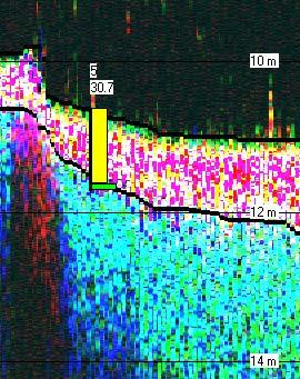
12 Single Beam Transect vs Multibeam Swath Single Beam Transect Multibeam
 B 5959.2-2.")
13 Estimating Survey Accuracy Inks Lake Multibeam Single Beam Data Source TIN Name Volume (acre-ft) V (%) Multibeam A <> TWDB Soundings (500ft spacing) B % TWDB Soundings & Interpolated Points C %
14 Pre-survey Field data collection Sediment coring Data analysis TIN generation

15 Field Data Collection 200 khz 50 khz 24 khz Data collected using single beam, multifrequency, sub-bottom profiling survey system 200, 50, 24 or 12 khz frequencies

16
17 Pre-survey Field data collection Sediment coring Data analysis TIN generation

18 Sediment Coring Coring conducted using vibracoring equipment 3-in diameter cores Sediment cores penetrate through postimpoundment sediment to pre-impoundment material

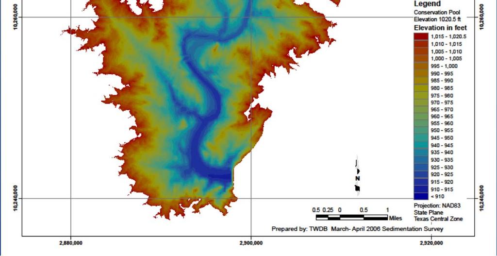
19 Sediment Coring Core analysis: Color Texture Water content Penetrative resistance Presence of organic materials
20 Pre-survey Field data collection Sediment coring Data analysis TIN generation

21 Data Analysis

22
23 Pre-survey Field data collection Sediment coring Data analysis TIN generation

24 Data Interpolation, TIN Model Generation Cleaned survey data imported to ArcGIS An anisotropic interpolation is used to assign depth values to a grid of points between survey transects TIN model created from current surface X,Y, Z points

25

26
27 Lake Buchanan 2006 Sedimentation Survey TWDB pre-impoundment estimate based on 2006 survey Volume comparisons at conservation pool elevation ft NGVD 29 (acre-feet) 920, volumetric survey 886,626 Volume difference (acre-feet) Number of years since impoundment Capacity loss rate (acrefeet/year) 34,
28

29
30 Lake Travis 2008 Sedimentation Survey TWDB pre-impoundment estimate based on 2008 survey Volume comparisons at conservation pool elevation ft NAVD 88 (acre-feet) 1,151, volumetric survey 1,134,863 Volume difference (acre-feet) Number of years since impoundment Capacity loss rate (acrefeet/year) 16,

31 Questions? Nathan Leber
SonTek HydroSurveyor M9 now powered by HYPACK! CASE STUDY: USGS HYDROSURVEYOR SURVEY OF FENA VALLEY RESERVOIR, GUAM
 SonTek HydroSurveyor M9 now powered by HYPACK! CASE STUDY: USGS HYDROSURVEYOR SURVEY OF FENA VALLEY RESERVOIR, GUAM Presenters Harold Orlinsky General Manager HYPACK Isaac Jones Product manager, SonTek
David Coffman, M.S. & Becky Griffith, Ph.D. July 31, 2013
 David Coffman, M.S. & Becky Griffith, Ph.D. July 31, 2013 Texas River Basins Sulphur River Watershed Sediment Sulphur River Watershed Sediment Sulphur River Watershed Sediment Sulphur River Watershed
Highland Lake Bathymetric Survey
 Highland Lake Bathymetric Survey Final Report, Prepared For: The Town of Highland Lake 612 Lakeshore Drive Oneonta, AL 35121 Prepared By: Tetra Tech 2110 Powers Ferry Road SE Suite 202 Atlanta, GA 30339
Bathymetric Survey of Select Dissolved Oxygen Impaired Reservoirs
 Bathymetric Survey of Select Dissolved Oxygen Impaired Reservoirs FY 2017 PROJECT #3 FY16/17 106 I-006400-15 TABLE A-1 LAKES Q-TRAK #17-085 PREPARED BY: OKLAHOMA WATER RESOURCES BOARD PREPARED FOR: OKLAHOMA
Historical Bathymetric Data for the Lower Passaic River
 Historical Bathymetric Data for the Lower Passaic River 4th Passaic River Symposium June 22nd, 2010 Dr. William Hansen Jeffrey Cranson Worcester State College Project Supported by The Hudson River Foundation
MaxDepth Aquatics, Inc.
 MaxDepth Aquatics, Inc. Bathymetry of Mirror Pond From Newport Bridge to Galveston Bridge Prepared for the City of Bend By Joseph Eilers & Benn Eilers MaxDepth Aquatics, Inc. Bend, OR June 2005 INTRODUCTION
GRAPEVINE LAKE MODELING & WATERSHED CHARACTERISTICS
 GRAPEVINE LAKE MODELING & WATERSHED CHARACTERISTICS Photo Credit: Lake Grapevine Boat Ramps Nash Mock GIS in Water Resources Fall 2016 Table of Contents Figures and Tables... 2 Introduction... 3 Objectives...
Remaining Capacity in Great Lakes Reservoirs
 US Army Corps of Engineers Detroit District Remaining Capacity in Great Lakes Reservoirs Storage Capacity Behind Great Lakes Dams Field Data and Modeling Motivation for project Project overview Data and
Lake Sedimentation Survey of Siloam Springs State Park Lake, Adams County, Illinois
 Contract Report 567 Lake Sedimentation Survey of Siloam Springs State Park Lake, Adams County, Illinois by Richard L. Allgire Office of Sediment & Wetland Studies Prepared for the Illinois Department of
USGS Flood Inundation Mapping of the Suncook River in Chichester, Epsom, Pembroke and Allenstown, New Hampshire
 USGS Flood Inundation Mapping of the Suncook River in Chichester, Epsom, Pembroke and Allenstown, New Hampshire NH Water & Watershed Conference Robert Flynn, USGS NH-VT Water Science Center March 23, 2012
Methods for Assessing Sedimentation in Reservoirs
 Methods for Assessing Sedimentation in Reservoirs Mark Jakubauskas, Research Associate Professor Frank denoyelles, Deputy Director and Professor Applied Science and Technology for Reservoir Assessment
Bathymetric Survey of Select Dissolved Oxygen Impaired Reservoirs
 Bathymetric Survey of Select Dissolved Oxygen Impaired Reservoirs FY 2018 PROJECT #3 FY18/19 106 I-006400-17 TABLE A-1 LAKES Q-TRAK #18-205 PREPARED BY: OKLAHOMA WATER RESOURCES BOARD PREPARED FOR: OKLAHOMA
Lake Forest Mapping ANALYSIS OF SHOALING AND POOL VOLUMES
 ANALYSIS OF SHOALING AND POOL VOLUMES Center for Applied Coastal Engineering & Science UNIVERSITY OF SOUTH ALABAMA 150 JAGUAR DRIVE, MOBILE, AL 36688 i Analysis of Shoaling and Pool Volumes Final Report
Chapter 7 Mudflow Analysis
 Chapter 7 Mudflow Analysis 7.0 Introduction This chapter provides information on the potential and magnitude of mud floods and mudflows that may develop in Aspen due to rainfall events, snowmelt, or rain
LOCATED IN INDIAN RIVER COUNTY PREPARED FOR S.J.R.W.M.D. AND F.W.C.D. DECEMBER, 2003 Updated 2007 Updated May 2014 PREPARED BY
 FELLSMERE WATER CONTROL DISTRICT EAST MASTER DRAINAGE PLAN AND STORMWATER HYDROLOGIC ANALYSIS OF THE GRAVITY DRAINAGE SYSTEM LOCATED BETWEEN THE EAST BOUNDARY, LATERAL U, THE MAIN CANAL, AND DITCH 24 LOCATED
Bathymetric and Sediment Survey of Centralia City Lake, Nemaha County, Kansas
 Bathymetric and Sediment Survey of Centralia City Lake, Nemaha County, Kansas Kansas Biological Survey Applied Science and Technology for Reservoir Assessment (ASTRA) Program Report 2010-06 (December 2010)
Bathymetric and Sediment Survey of Atchison County Lake, Atchison County, Kansas
 Bathymetric and Sediment Survey of Atchison County Lake, Atchison County, Kansas Kansas Biological Survey Applied Science and Technology for Reservoir Assessment (ASTRA) Program Report 2010-04 (November
Observed bed elevation changes in the data may arise as a result of any of several causes:
 10 July 2014 TECHNICAL MEMORANDUM: INTRODUCTION NEWARK BAY STUDY AREA, NEW JERSEY BATHYMETRIC COMPARISON AND ANALYSIS Periodic single- and multi-beam sonar bathymetric surveys within Newark Bay (Bay) in
A Comprehensive Inventory of the Number of Modified Stream Channels in the State of Minnesota. Data, Information and Knowledge Management.
 A Comprehensive Inventory of the Number of Modified Stream Channels in the State of Minnesota Data, Information and Knowledge Management Glenn Skuta Environmental Analysis and Outcomes Division Minnesota
Chapter 7 Mudflow Analysis
 Chapter 7 Mudflow Analysis 7.0 Introduction This chapter provides information on the potential and magnitude of mud floods and mudflows that may develop in Aspen due to rainfall events, snowmelt, or rain
Sedimentation Survey of Lake Paradise and Lake Mattoon, Mattoon, Illinois
 Contract Report 2003-04 Sedimentation Survey of Lake Paradise and Lake Mattoon, Mattoon, Illinois by William C. Bogner Prepared for the CMT Engineering Company City of Mattoon and Illinois Environmental
Bathymetric and Sediment Survey of Banner Creek Reservoir, Jackson County, Kansas
 Bathymetric and Sediment Survey of Banner Creek Reservoir, Jackson County, Kansas Kansas Biological Survey Applied Science and Technology for Reservoir Assessment (ASTRA) Program Report 2010-05 (December
PRELIMINARY DRAFT FOR DISCUSSION PURPOSES
 Memorandum To: David Thompson From: John Haapala CC: Dan McDonald Bob Montgomery Date: February 24, 2003 File #: 1003551 Re: Lake Wenatchee Historic Water Levels, Operation Model, and Flood Operation This
Challenges in Calibrating a Large Watershed Model with Varying Hydrogeologic Conditions
 Challenges in Calibrating a Large Watershed Model with Varying Hydrogeologic Conditions Presented by Johnathan R. Bumgarner, P.G., Celine A.L. Louwers, & Monica P. Suarez, P.E. In cooperation with the
Bathymetric and Sediment Survey of Kanopolis Reservoir, Ellsworth County, Kansas
 Bathymetric and Sediment Survey of Kanopolis Reservoir, Ellsworth County, Kansas Kansas Biological Survey Applied Science and Technology for Reservoir Assessment (ASTRA) Program Report 2008-09 (April 2009)
Assessment of Lake Forest Lake Sediment Trapping Efficiency and Capacity. Marlon R. Cook Groundwater Assessment Program Geological Survey of Alabama
 Assessment of Lake Forest Lake Sediment Trapping Efficiency and Capacity Marlon R. Cook Groundwater Assessment Program Geological Survey of Alabama Impacts of the Lake at Lake Forest on the connectivity
Lake Worth Lagoon Hydrographic Survey Report
 C-51 Canal Sediment Trap Lake Worth Lagoon Hydrographic Survey Report July 11, 2013 South Florida Water Management District 3301 Gun Club Road West Palm Beach, Florida 33406 Table of Contents Background...
Estimated Sediment Volume: Bridge Street Dam Impoundment, Royal River, Yarmouth, Maine
 University of Southern Maine USM Digital Commons Publications Casco Bay Estuary Partnership (CBEP) 2015 Estimated Sediment Volume: Bridge Street Dam Impoundment, Royal River, Yarmouth, Maine Stantec Follow
Appendix E Guidance for Shallow Flooding Analyses and Mapping
 Appendix E Guidance for Shallow Flooding Analyses and Mapping E.1 Introduction Different types of shallow flooding commonly occur throughout the United States. Types of flows that result in shallow flooding
REGIONAL SEDIMENT MANAGEMENT: A GIS APPROACH TO SPATIAL DATA ANALYSIS. Lynn Copeland Hardegree, Jennifer M. Wozencraft 1, Rose Dopsovic 2 INTRODUCTION
 REGIONAL SEDIMENT MANAGEMENT: A GIS APPROACH TO SPATIAL DATA ANALYSIS Lynn Copeland Hardegree, Jennifer M. Wozencraft 1, Rose Dopsovic 2 ABSTRACT: Regional sediment management (RSM) requires the capability
Varying Bathymetric Data Collection Methods and their Impact on Impoundment Volume and Sediment Load Calculations I.A. Kiraly 1, T.
 Varying Bathymetric Data Collection Methods and their Impact on Impoundment Volume and Sediment Load Calculations I.A. Kiraly 1, T. Sullivan 2 1 Gomez and Sullivan Engineers, D.P.C., 41 Liberty Hill Road,
Hydrographic Surveys for Six Water Bodies in Eastern Nebraska,
 University of Nebraska - Lincoln DigitalCommons@University of Nebraska - Lincoln Publications of the US Geological Survey US Geological Survey 2008 Hydrographic Surveys for Six Water Bodies in Eastern
Geological Survey of Alabama Groundwater Assessment Program
 Geological Survey of Alabama Groundwater Assessment Program Hydrogeologic Characterization and Groundwater Source Development Assessment for Area 2, Southwestern Alabama Gheorghe M. Ponta, Marlon R. Cook,
Bathymetric and Sediment Survey of Elk City Reservoir, Montgomery County, Kansas
 Bathymetric and Sediment Survey of Elk City Reservoir, Montgomery County, Kansas Kansas Biological Survey Applied Science and Technology for Reservoir Assessment (ASTRA) Program Report 2010-01 (December
Bathymetric and Sediment Survey of Fall River Reservoir, Greenwood County, Kansas
 Bathymetric and Sediment Survey of Fall River Reservoir, Greenwood County, Kansas Kansas Biological Survey Applied Science and Technology for Reservoir Assessment (ASTRA) Program Report 2010-02 (May 2011)
H.A.R.S. PRA #1 (Historic Area Remediation Site)
") H.A.R.S. PRA #1 (Historic Area Remediation Site) 2009 Multibeam Bathymetry TABLE OF CONTENTS Page LIST OF TABLES 2 LIST OF FIGURES 3 1.0 INTRODUCTION 4 2.0 OBJECTIVE 4 3.0 PROCEDURE 4 3.1 DATA ACQUISITION
H.A.R.S. PRA #1 (Historic Area Remediation Site) 2009 Multibeam Bathymetry TABLE OF CONTENTS Page LIST OF TABLES 2 LIST OF FIGURES 3 1.0 INTRODUCTION 4 2.0 OBJECTIVE 4 3.0 PROCEDURE 4 3.1 DATA ACQUISITION
Bathymetric Survey of John Redmond Reservoir, Coffey County, Kansas
 Bathymetric Survey of John Redmond Reservoir, Coffey County, Kansas Kansas Biological Survey Applied Science and Technology for Reservoir Assessment (ASTRA) December 2007 SUMMARY During March and April
Colorado River: Mile 8 to Mile 13.5
 Colorado River: Mile to Mile. +00 +00 +00 0+00 0+00 +00 00+00 +00 +00 +00 +00 +00 +00 +00 +00 +00 +00 0+00 +00 +00 +00 +00 +00 0+00 +00 +00 0+00 +00 +00 +00 +00 0+00 +00 +00 +00 +00 +00 +00 +00 0+00 0+00
LIDAR: Statutory Compliance Benefits for Nebraska Natural Resources
 LIDAR: Statutory Compliance Benefits for Nebraska Natural Resources 2011 Nebraska GIS Symposium La Vista, NE April 21, 2011 Doug Hallum, P.G. Integrated Water Management Coordinator Nebraska Department
North Carolina Simplified Inundation Maps For Emergency Action Plans December 2010; revised September 2014; revised April 2015
 North Carolina Simplified Inundation Maps For Emergency Action Plans December 2010; revised September 2014; revised April 2015 INTRODUCTION Emergency Action Plans (EAPs) are critical to reducing the risks
LAKE FOREST MAPPING STUDY
 LAKE FOREST MAPPING STUDY ANALYSIS OF SHOALING AND POOL VOLUMES Bret M. Webb, PhD, PE, DCE August 18, 2016 Mobile Bay National Estuary Program Project Implementation Committee Meeting Presentation Map
Bathymetric And Sediment Survey Of The Tongue Of The Ocean, Bahamas: Part 1: Bathymetry And Sediments (WHOI) By William D Athearn
 By William D Athearn") Bathymetric And Sediment Survey Of The Tongue Of The Ocean, Bahamas: Part 1: Bathymetry And Sediments (WHOI) By William D Athearn If searching for the ebook Bathymetric and sediment survey of the Tongue
Bathymetric And Sediment Survey Of The Tongue Of The Ocean, Bahamas: Part 1: Bathymetry And Sediments (WHOI) By William D Athearn If searching for the ebook Bathymetric and sediment survey of the Tongue
3. MARINE HABITAT RESTORATION
 Feasibility Study for Restoration of Titlow Lagoon Fish Passage South Puget Sound Salmon Enhancement Group 3. MARINE HABITAT RESTORATION Marine habitat restoration at Titlow Park could include restoration
Coastal Inlets Research Program US Army Corps of Engineers Engineering Research and Development Center
 Coastal Inlets Research Program US Army Corps of Engineers Engineering Research and Development Center Site of Moriches Inlet Nov. 1951 Julie Dean Rosati and Nicholas C. Kraus, CIRP Program Manager Shinnecock
Multibeam Hydrographic Survey Use for Construction Control of Filling and Ground Improvement Activities
 Multibeam Hydrographic Survey Use for Construction Control of Filling and Ground Improvement Activities WEDA Cincinnati April 10, 2014 Ray Wood C.Eng Executive Vice President Fugro Consultants Inc Advantages
Fish Passage Studies III: Sediment Redistribution and Impact Analysis: Springborn Dam - Enfield, Connecticut
 University of Massachusetts Amherst ScholarWorks@UMass Amherst International Conference on Engineering and Ecohydrology for Fish Passage International Conference on Engineering and Ecohydrology for Fish
MISSISSIPPI COASTAL IMPROVEMENTS
 MISSISSIPPI COASTAL IMPROVEMENTS PROGRAM (MsCIP) Comprehensive Barrier 237 27 200 237 27 200 Island 237 Restoration 27 200 Plan 80 9 27 252 74.59 255 255 255 0 0 0 63 63 63 3 32 22 239 65 53 0 35 20 2
Adaptive Bathymetric System Mapping of Champagne Reef and Scott s Head
 Adaptive Bathymetric System Mapping of Champagne Reef and Scott s Head TRAVIS ROOF¹ ABSRACT Bathymetric maps are crucial not only for navigational purposes but also for conservation of marine environments.
WATER MANAGEMENT REPORT FOR PAGE ESTATES
 WATER MANAGEMENT REPORT FOR PAGE ESTATES SLB Consulting of SW Florida, LLC PO Box 2826 Bonita Springs, FL. 34133 Phone: 239-948-9566 sandra@slbconsult.com C.O.A. # 25395 September 1, 2014 Sandra L. Bottcher
Hydrology and Floodplain Analysis, Chapter 10
 Hydrology and Floodplain Analysis, Chapter 10 Hydrology and Floodplain Analysis, Chapter 10.1 Introduction to GIS GIS Geographical Information System Spatial Data Data linked with geographical location
Appendix I. Dredged Volume Estimates. Draft Contractor Document: Subject to Continuing Agency Review
 Appendix I Dredged Volume Estimates Draft Contractor Document: Subject to Continuing Agency Review Interoffice Correspondence Date: April 6, 2007 To: L. Bossi (WHI) Copy: S. Thompson (WHI), B. Fidler (NNJ)
Illinois State Water Survey Division
 Illinois State Water Survey Division SURFACE WATER SECTION SWS Contract Report 413 AT THE UNIVERSITY OF ILLINOIS SEDIMENTATION SURVEY OF DAWSON LAKE, MORAINE VIEW STATE PARK, MC LEAN COUNTY, ILLINOIS by
How Do Human Impacts and Geomorphological Responses Vary with Spatial Scale in the Streams and Rivers of the Illinois Basin?
 How Do Human Impacts and Geomorphological Responses Vary with Spatial Scale in the Streams and Rivers of the Illinois Basin? Bruce Rhoads Department of Geography University of Illinois at Urbana-Champaign
FORECAST-BASED OPERATIONS AT FOLSOM DAM AND LAKE
 FORECAST-BASED OPERATIONS AT FOLSOM DAM AND LAKE 255 237 237 237 217 217 217 200 200 200 0 163 131 Bridging the Gap163Conference 255 0 132 255 0 163 122 The Dana on Mission Bay San Diego, CA January 28,
Bathymetric and Sediment Survey of Pottawatomie Lake #1, Pottawatomie County, Kansas
 Bathymetric and Sediment Survey of Pottawatomie Lake #1, Pottawatomie County, Kansas Kansas Biological Survey Applied Science and Technology for Reservoir Assessment (ASTRA) Program Report 2010-10 (October
Side Scan Sonar Results for Additional Hardbottom Habitat Identification in Charleston Entrance Channel
 U.S. Army Corps of Engineers Charleston District APPENDIX H CHARLESTON HARBOR POST 45 BENEFICIAL USE OF DREDGED MATERIAL SUPPLEMENTAL ENVIRIONMENTAL ASSESSMENT CHARLESTON, SOUTH CAROLINA Side Scan Sonar
Hydrographical Surveying of the Subaqueous Delta Plain of the River Rhine at Lake Constance
 Hydrographical Surveying of the Subaqueous Delta Plain of the River Rhine at Lake Constance Erwin Heine Institute of Surveying BOKU University Vienna, AUSTRIA Content Introduction Universität für Bodenkultur
Water Volume Calculation of Hill Country Trinity Aquifer Blanco, Hays, and Travis Counties, Central Texas
 Water Volume Calculation of Hill Country Trinity Aquifer Blanco, Hays, and Travis Counties, Central Texas GIS and GPS Applications in Earth Science Saya Ahmed December, 2010 1 Introduction: Trinity Aquifer
3.0 TECHNICAL FEASIBILITY
 3.0 TECHNICAL FEASIBILITY 3.1 INTRODUCTION To enable seasonal storage and release of water from Lake Wenatchee, an impoundment structure would need to be constructed on the lake outlet channel. The structure
MINNESOTA DEPARTMENT OF TRANSPORTATION OFFICE OF LAND MANAGEMENT SURVEYING AND MAPPING SECTION PHOTOGRAMMETRY UNIT
 JULY 1, 2001 MINNESOTA DEPARTMENT OF TRANSPORTATION OFFICE OF LAND MANAGEMENT SURVEYING AND MAPPING SECTION PHOTOGRAMMETRY UNIT SPECIAL PROVISIONS FOR: GROUP 3: DIGITAL TERRAIN MODEL/DIGITAL ELEVATION
ARTICLE 5 (PART 2) DETENTION VOLUME EXAMPLE PROBLEMS
 DETENTION VOLUME EXAMPLE PROBLEMS") ARTICLE 5 (PART 2) DETENTION VOLUME EXAMPLE PROBLEMS Example 5.7 Simple (Detention Nomograph) Example 5.8 Offsite and Unrestricted Areas (HEC-HMS) Example 5.9 Ponds in Series w/ Tailwater (HEC-HMS) Example
ARTICLE 5 (PART 2) DETENTION VOLUME EXAMPLE PROBLEMS Example 5.7 Simple (Detention Nomograph) Example 5.8 Offsite and Unrestricted Areas (HEC-HMS) Example 5.9 Ponds in Series w/ Tailwater (HEC-HMS) Example
Dual Echo Sounder Bathymetric Survey for Enhanced Management of Ruiru Reservoir, Kenya
 Open Access Journal Journal of Sustainable Research in Engineering Vol. 3 (4) 2017, 113-118 Journal homepage: http://sri.jkuat.ac.ke/ojs/index.php/sri Dual Echo Sounder Bathymetric Survey for Enhanced
EAGLES NEST AND PIASA ISLANDS
 EAGLES NEST AND PIASA ISLANDS HABITAT REHABILITATION AND ENHANCEMENT PROJECT MADISON AND JERSEY COUNTIES, ILLINOIS ENVIRONMENTAL MANAGEMENT PROGRAM ST. LOUIS DISTRICT FACT SHEET I. LOCATION The proposed
Valenciano Reservoir Safe Yield Study. Prepared by: CSA Architects & Engineers, LLP
 Valenciano Reservoir Safe Yield Study Prepared by: CSA Architects & Engineers, LLP CSA Group Prepared for: Puerto Rico Aqueduct and Sewer Authority Planning TABLE OF CONTENTS 1 Introduction...1 1.1 Safe
Groundwater Replenishment In The Coachella Valley, CA. WESTCAS 2018 Annual Conference June 21, 2018 Zoe Rodriguez del Rey, Water Resources
 Groundwater Replenishment In The Coachella Valley, CA WESTCAS 2018 Annual Conference June 21, 2018 Zoe Rodriguez del Rey, Water Resources Coachella Valley Indio Mecca Palm Springs La Quinta Thermal 2 Coachella
Hydroacoustic survey and bathymetric map creation for Brant Lake, New York
 Hydroacoustic survey and bathymetric map creation for Brant Lake, New York Holly A. Waterfield CLM 1 INTRODUCTION Brant Lake is located in Warren County, New York, within the bounds of the Adirondack Park.
Geological record of severe storm impacts along the Texas Coast. Davin Wallace 1, John Anderson 1, Winnie Yu 1 and Antonio Rodriguez 2
 Geological record of severe storm impacts along the Texas Coast Davin Wallace 1, John Anderson 1, Winnie Yu 1 and Antonio Rodriguez 2 1 2 Motivation Understand natural evolution of stressed barrier island
Presented by: Bryan Bloch GIS Specialist DNREC Division of Watershed Stewardship
 Presented by: Bryan Bloch GIS Specialist DNREC Division of Watershed Stewardship Bryan Hall, AICP Sussex County Circuit Rider Planner, Office of State Planning Coordination, OMB November 19, 2012 UD Sustainable
LiDAR APPLICATIONS REMS6090. Assignment 2 HYDROLOGICAL APPLICATIONS of LiDAR DATA Due Date April 8, Venessa Bennett W
 LiDAR APPLICATIONS REMS6090 Assignment 2 HYDROLOGICAL APPLICATIONS of LiDAR DATA Due Date April 8, 2015 Venessa Bennett W0279429 1.0 Introduction High accuracy Digital Elevation Models (DEM) derived from
APPROVED JURISDICTIONAL DETERMINATION FORM U.S. Army Corps of Engineers
 APPROVED JURISDICTIONAL DETERMINATION FORM U.S. Army Corps of Engineers This form should be completed by following the instructions provided in Section IV of the JD Form Instructional Guidebook. SECTION
Seagrass Transplantation & Environmental & Marine Consulting Services, Inc. Drew Campbell, Vice President & Lead Scientst.
 Indian River Lagoon Symposium Seagrass Transplantation & Project Considerations Environmental & Marine Consulting Services, Inc. Drew Campbell, Vice President & Lead Scientst March 26 th, 2013 Regulatory
Mississippi River (Pool 2) 2-D ADH Model Development
 2-D ADH Model Development") Appendix E: Mississippi River (Pool 2) 2-D ADH Model Development (PREPARED BY WEST CONSULTANTS, 2011) Lower Pool 2 Channel Management Study: Boulanger Bend to Lock and Dam No. 2 US Army Corps of Engineers
Appendix E: Mississippi River (Pool 2) 2-D ADH Model Development (PREPARED BY WEST CONSULTANTS, 2011) Lower Pool 2 Channel Management Study: Boulanger Bend to Lock and Dam No. 2 US Army Corps of Engineers
Detroit 516 Activities
 Detroit 516 Activities Dam Capacity Study Sediment Workshop in Traverse City START 2.0 Saginaw River Study Dam Capacity Study A progress report Outline Study Objective (Why are we doing this?) Reservoir
RESERVOIR DRAWDOWN RATES/RESERVOIR DRAWDOWN TEST Iron Gate, Copco (I & II), and JC Boyle Dams
, and JC Boyle Dams") TECHNICAL MEMORANDUM No. 1 TO: Michael Bowen California Coastal Conservancy Geotechnical & Earthquake Engineering Consultants CC: Eric Ginney Philip Williams & Associates PREPARED BY: Paul Grant SUBJECT:
TECHNICAL MEMORANDUM No. 1 TO: Michael Bowen California Coastal Conservancy Geotechnical & Earthquake Engineering Consultants CC: Eric Ginney Philip Williams & Associates PREPARED BY: Paul Grant SUBJECT:
INFLOW DESIGN FLOOD CONTROL SYSTEM PLAN 40 C.F.R. PART PLANT YATES ASH POND 2 (AP-2) GEORGIA POWER COMPANY
 GEORGIA POWER COMPANY") INFLOW DESIGN FLOOD CONTROL SYSTEM PLAN 40 C.F.R. PART 257.82 PLANT YATES ASH POND 2 (AP-2) GEORGIA POWER COMPANY EPA s Disposal of Coal Combustion Residuals from Electric Utilities Final Rule (40 C.F.R.
INFLOW DESIGN FLOOD CONTROL SYSTEM PLAN 40 C.F.R. PART 257.82 PLANT YATES ASH POND 2 (AP-2) GEORGIA POWER COMPANY EPA s Disposal of Coal Combustion Residuals from Electric Utilities Final Rule (40 C.F.R.
Subsurface Maps. K. W. Weissenburger. Isopach. Isochore. Conoco, Inc. Ponca City, Oklahoma, U.S.A.
 Subsurface Maps K. W. Weissenburger Conoco, Inc. Ponca City, Oklahoma, U.S.A. INTRODUCTION Reservoir properties are mapped to promote optimal field development. Subsurface maps dictate well placement and
Appendix J Vegetation Change Analysis Methodology
 Appendix J Vegetation Change Analysis Methodology Regional Groundwater Storage and Recovery Project Draft EIR Appendix-J April 2013 APPENDIX J- LAKE MERCED VEGETATION CHANGE ANALYSIS METHODOLOGY Building
Lake Worth Lagoon Waterways Town of Palm Beach, Florida North Waterway
 North Waterway STATE OF FLORIDA PROJECT AREA N R-100 R-101 R-102 R-103 R-104 R-105 R-106 R-107 R-108 R-109 R-0 R-1 T-2 R-3 R-4 R-5 R-6 R-7 R-8 North Waterway Central Waterway South Waterway Dredge Hole
Bathymetric and Sediment Survey of Alma City Lake, Wabaunsee County, Kansas
 Bathymetric and Sediment Survey of Alma City Lake, Wabaunsee County, Kansas Kansas Biological Survey Applied Science and Technology for Reservoir Assessment (ASTRA) Program Report 2011-13 (March 2011)
DUCK POND WATERSHED MANAGEMENT PLAN UPDATE APPENDICES. Prepared for:
 DUCK POND WATERSHED MANAGEMENT PLAN UPDATE APPENDICES Prepared for: Stormwater Management Section Public Works Department, Hillsborough County 60 E. Kennedy Blvd Tampa, FL 33602 Engineers/Planners/Scientists
Updating Bathymetric Surveys for Drinking Water Reservoirs
 Updating Bathymetric Surveys for Drinking Water Reservoirs Crystal K. Williams Rick Twait Catherine O Reilly Eric Peterson INTRODUCTION Globally high water demand - Drinking water - Irrigation in agriculture
GEOGRAPHIC INFORMATION SYSTEMS
 GEOGRAPHIC INFORMATION SYSTEMS 4-H Round-Up Community Transitions Workshop Daniel Hanselka June 14, 2011 Goals of the Workshop Answer the question: What is GIS? Uses of GIS. Some of the Common Terminology
Management and Use of LiDAR-derived Information. Elizabeth Cook, GIS Specialist
 Management and Use of LiDAR-derived Information Elizabeth Cook, GIS Specialist Advanced LiDAR Workshop March 15, 2012 50-100 gb/county Now What? Project Deliverables LAS mass point files, classification
AERIAL DATA SERVICES
 AERIAL DATA SERVICES f o r I N D U S T R I A L A P P L I C AT I O N S C O N S T R U C T I O N * A G R I C U L T U R E * E N E R G Y * E N V I R O N M E N T A L A e r o L o g i x C o n s u l t i n g I n
GAM Run by Ali H. Chowdhury Ph.D., P.G. Texas Water Development Board Groundwater Resources Division (512)
") GAM Run 7-18 by Ali H. Chowdhury Ph.D., P.G. Texas Water Development Board Groundwater Resources Division (512) 936-0834 July 13, 2007 EXECUTIVE SUMMARY The groundwater availability model for the Hill
GAM Run 7-18 by Ali H. Chowdhury Ph.D., P.G. Texas Water Development Board Groundwater Resources Division (512) 936-0834 July 13, 2007 EXECUTIVE SUMMARY The groundwater availability model for the Hill
GSA DATA REPOSITORY
 GSA DATA REPOSITORY 2009206 Miner et al. Supplemental Material Bathymetric Survey Methods The bathymetric data for the area were gathered using a single-beam bathymetric survey rig mounted aboard a 21-foot
A Detailed Examination of DTM Creation Methods and Sources. Study Area Overview
 A Detailed Examination of DTM Creation Methods and Sources Adam Mosbrucker & Melinda Lamb Geography 593: Dec. 2 nd, 2010 Study Area Overview Mt. St. Helens -active volcano many eruptions in the past 30
Pierce Cedar Creek Institute GIS Development Final Report. Grand Valley State University
 Pierce Cedar Creek Institute GIS Development Final Report Grand Valley State University Major Goals of Project The two primary goals of the project were to provide Matt VanPortfliet, GVSU student, the
Sedimentation Survey of Lake Decatur s Basin 6, Macon County, Illinois
 Contract Report 2001-07 Sedimentation Survey of Lake Decatur s Basin 6, Macon County, Illinois by William C. Bogner Prepared for the City of Decatur May 2001 Illinois State Water Survey Watershed Science
AN ASSESSMENT OF THE IMPACT OF RETENTION PONDS
 AN ASSESSMENT OF THE IMPACT OF RETENTION PONDS FOR SEDIMENT TRAPPING IN THE ADA CREEK AND LONGWOOD COVE USING REMOTELY SENSED DATA AND GIS ANALYSIS Sudhanshu Sekhar Panda Associate Professor, GIS/Env.
Hydraulic and Sediment Transport Modeling Strategy
 Appendix B Hydraulic and Sediment Transport Modeling Strategy May 2014 Technical Memorandum Channel Capacity Report January 2015 San Joaquin River Restoration Program Hydraulic and Sediment Transport Modeling
Washington, D.C. Laura Benneyworth AMEC, Nashville, TN February 2009
 Turning Data Into Information at Wolf Creek Dam ESRI s Federal User s Conference, Washington, D.C. Laura Benneyworth AMEC, Nashville, TN February 2009 Wolf Creek Dam Acknowledgments USACE, Nashville District
Geostatistical Density Mapping
 Geostatistical Density Mapping Sean A. McKenna and Barry Roberts (SNL) Brent Pulsipher & John Hathaway (PNNL) 2008 Partners in Environmental Technology Technical Symposium & Workshop Sandia is a multiprogram
Bathymetry Data and Models: Best Practices
 Bathymetry Data and Models: Best Practices Barry Eakins & Lisa Taylor The NOAA National Geophysical Data Center Over 600 data types - from the core of the Earth to the surface of the Sun NGDC Bathymetry
Development and application of demonstration MIKE 21C morphological model for a bend in Mekong River
 Development and application of demonstration MIKE 21C morphological model for a bend in Mekong River September 2015 0 Table of Contents 1. Introduction... 2 2. Data collection... 3 2.1 Additional data...
LOMR SUBMITTAL LOWER NEHALEM RIVER TILLAMOOK COUNTY, OREGON
 LOMR SUBMITTAL LOWER NEHALEM RIVER TILLAMOOK COUNTY, OREGON Prepared for: TILLAMOOK COUNTY DEPARTMENT OF COMMUNITY DEVELOPMENT 1510-B THIRD STREET TILLAMOOK, OR 97141 Prepared by: 10300 SW GREENBURG ROAD,
Inspection of Waterfront Facilities Using Vessel-Based Remote Sensing Mitchell, Del Bello, Suarez
 Inspection of Waterfront Facilities Using Vessel-Based Remote Sensing Mitchell, Del Bello, Suarez American Association of Port Authorities Facilities Engineering Conference October 20-22, 2015 Waterfront
INTRODUCTION TO HYDROLOGIC MODELING USING HEC-HMS
 INTRODUCTION TO HYDROLOGIC MODELING USING HEC-HMS By Thomas T. Burke, Jr., PhD, PE Luke J. Sherry, PE, CFM Christopher B. Burke Engineering, Ltd. October 8, 2014 1 SEMINAR OUTLINE Overview of hydrologic
Illinois River Sediment Quality and Beneficial Use Options
 Illinois River Sediment Quality and Beneficial Use Options John C. Marlin Illinois Sustainable Technology Center Robert G. Darmody Dept. of Natural Resources and Environmental Science University of Illinois
Probabilistic Evaluation of a Meandering Low-Flow Channel. February 24 th, UMSRS
 Probabilistic Evaluation of a Meandering Low-Flow Channel February 24 th, 2014 2014 UMSRS 1 2 acknowledgments Low- Flow Channel (LFC) overview Proposed Diversion Channel collects runoff from: The Rush