Management and Use of LiDAR-derived Information. Elizabeth Cook, GIS Specialist
|
|
|
- Leslie Brooks
- 5 years ago
- Views:
Transcription
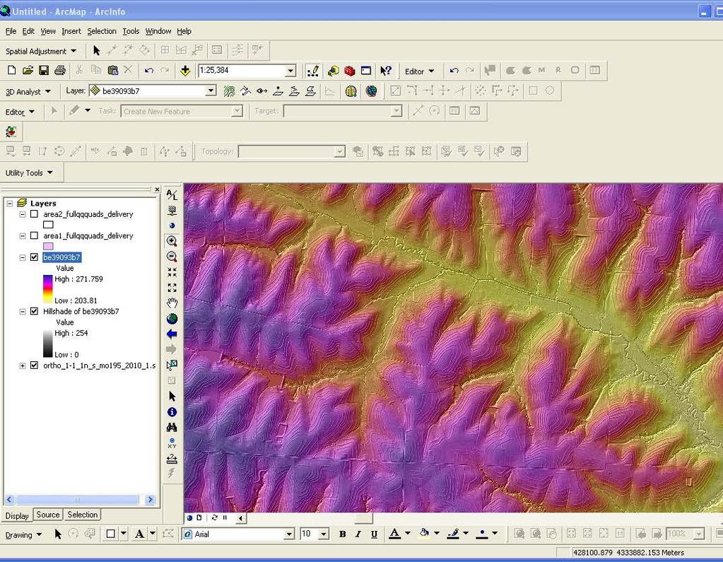
1 Management and Use of LiDAR-derived Information Elizabeth Cook, GIS Specialist Advanced LiDAR Workshop March 15, 2012

2 gb/county Now What?
3 Project Deliverables LAS mass point files, classification of points to contract specifications Raster (ESRI Grid,.img or other) bare-earth DEMs, per tiling schema Control points for independent vertical QA Misc tile indexes, breaklines, QA reports, metadata files
4 LiDAR Index
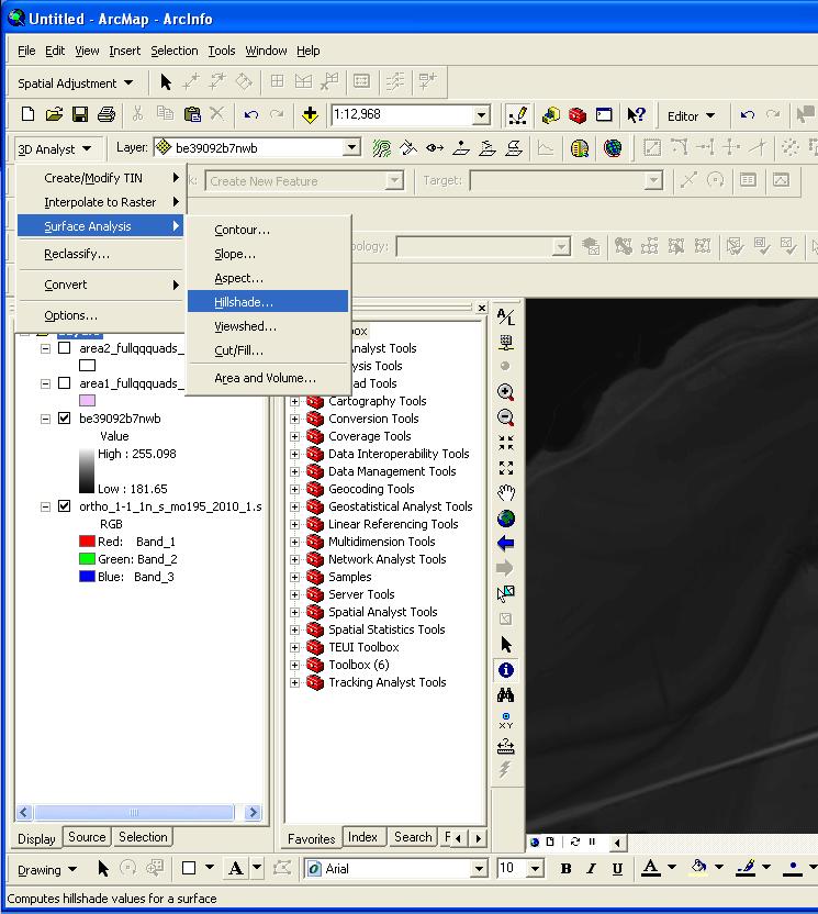
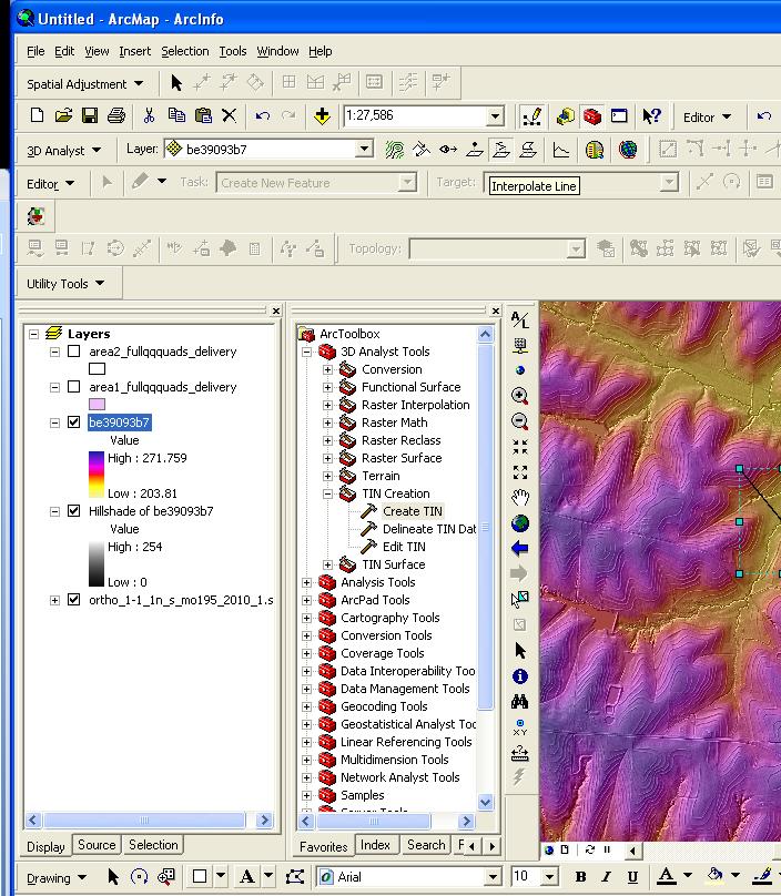
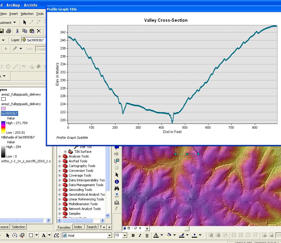
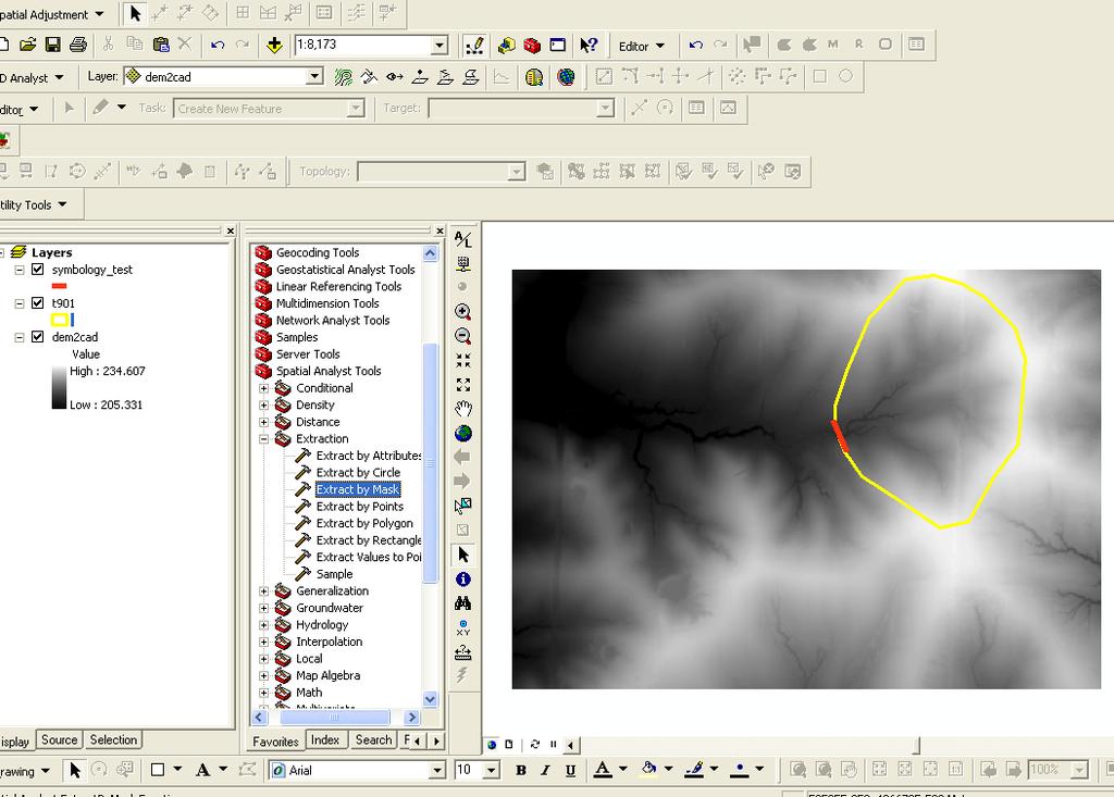
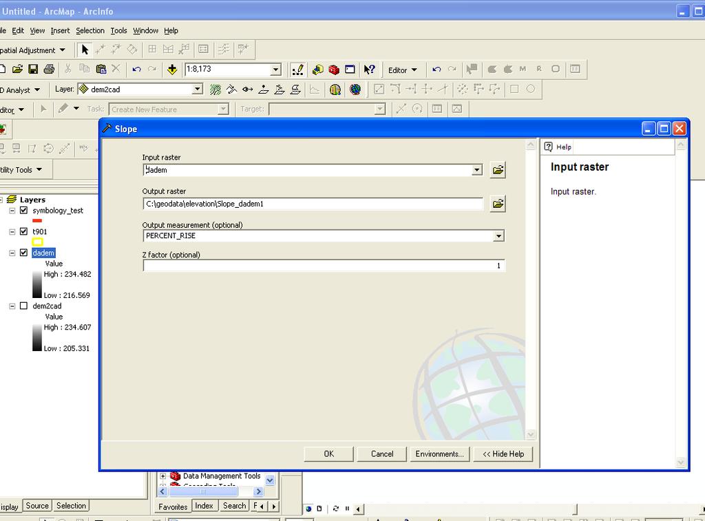
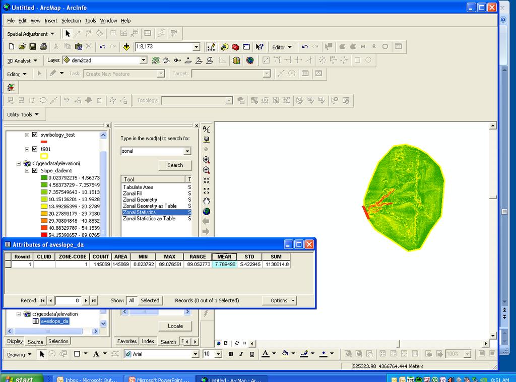
5 LiDAR Products for Users Elevation Models (DEMs* or TINs) Relief (Hillshade) Maps * Contour Maps Slope Maps Aspect Maps LAS files for first-return processing*
6

7

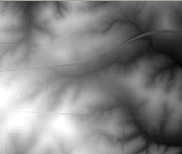
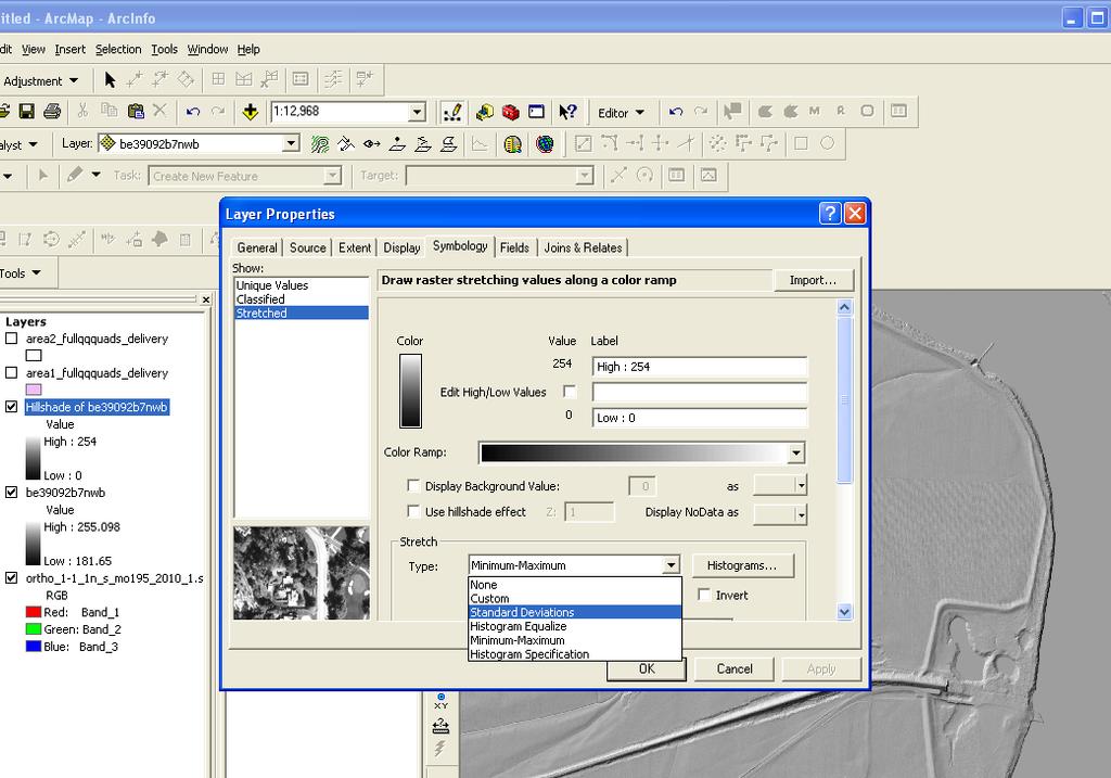
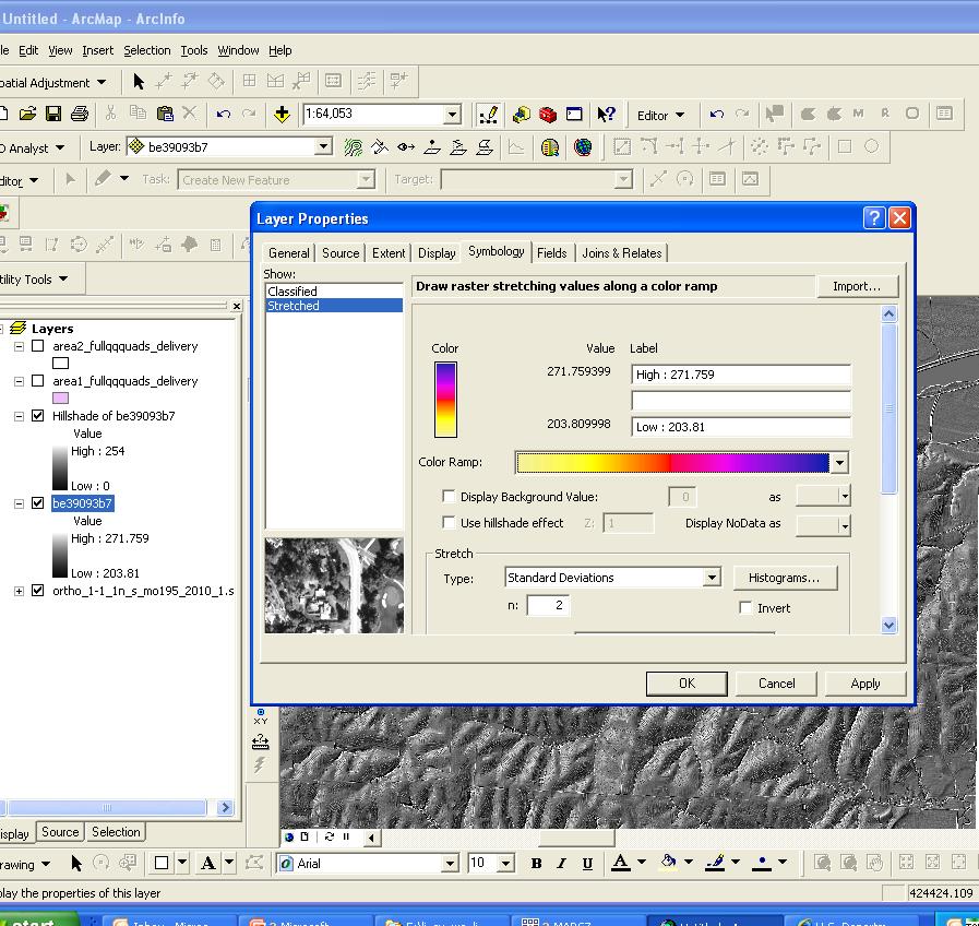
8 LiDAR Products - Hillshades
9
10
11
12
13
14
15
16

17 LiDAR Products - Contours

18 Creates contours in feet Increments using vertical meters data

19
20 Considerations for Making Contours Smooth DEM using Focal Statistics Mean Produce contours for relatively small areas; algorithm prone to crashing or locking up on large areas Encourage use of raster elevation tools

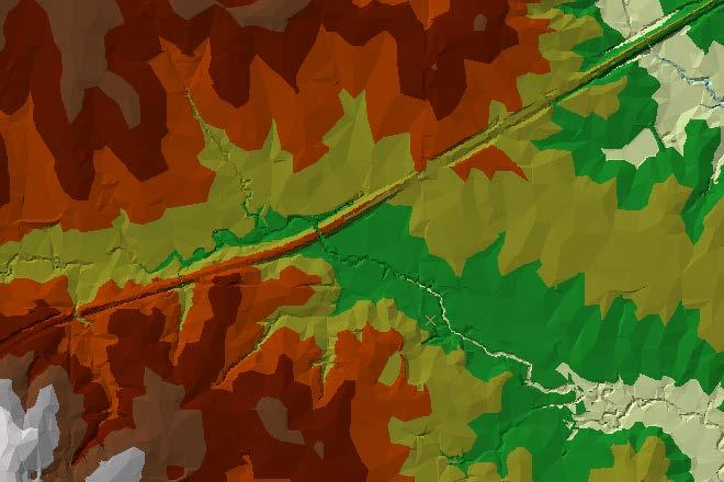
21 LiDAR Products Land Slopes

22
23
24
25
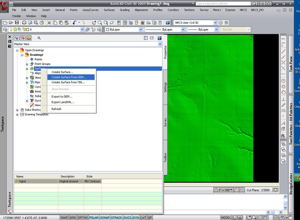
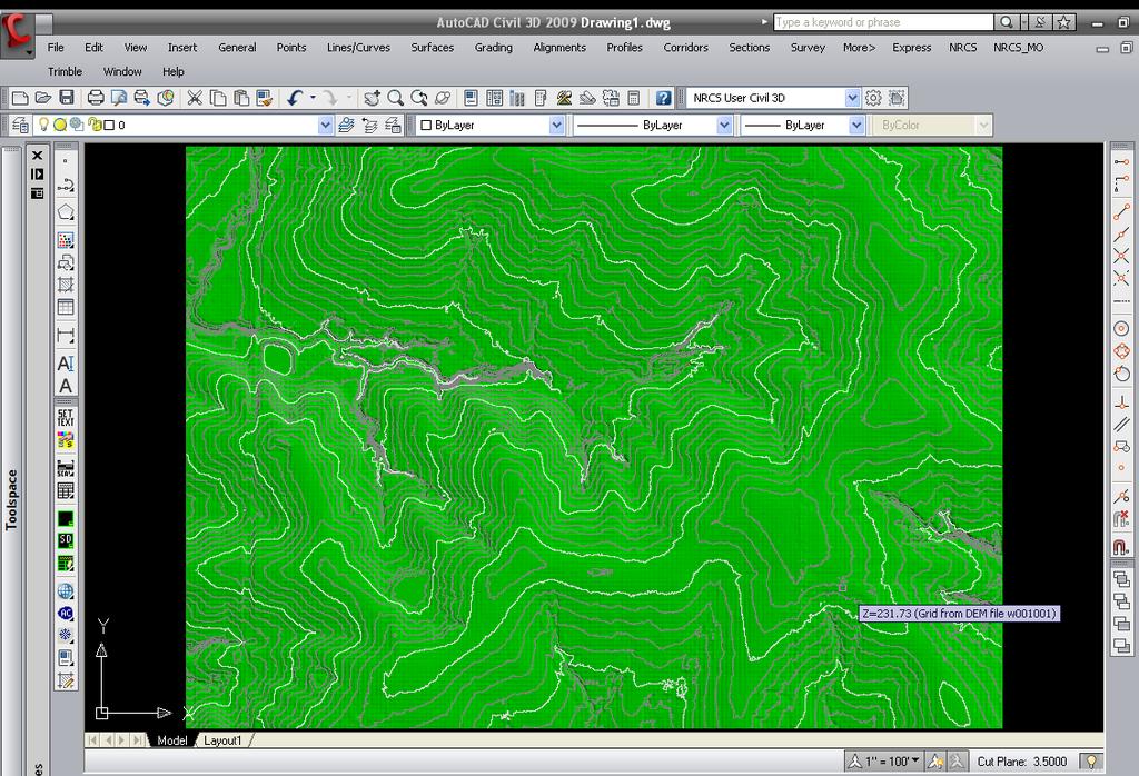
26 LiDAR Products for Users Elevation Models (DEMs* or TINs) Relief (Hillshade) Maps * Contour Maps Slope Maps Aspect Maps LAS files for first-return processing*
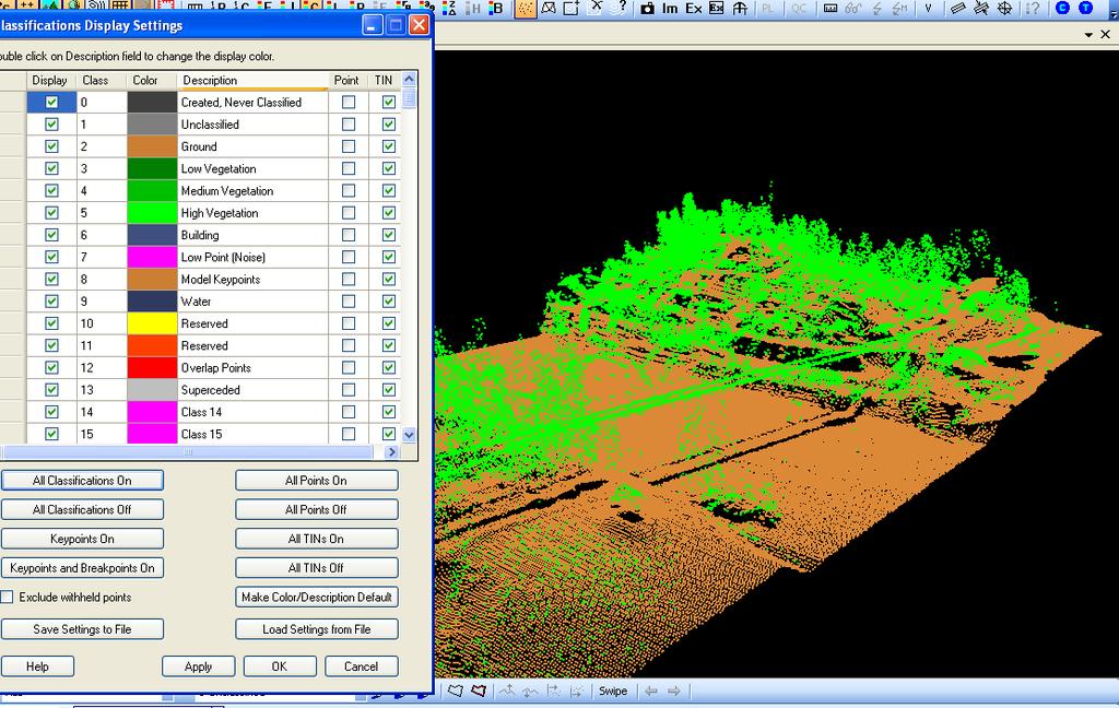
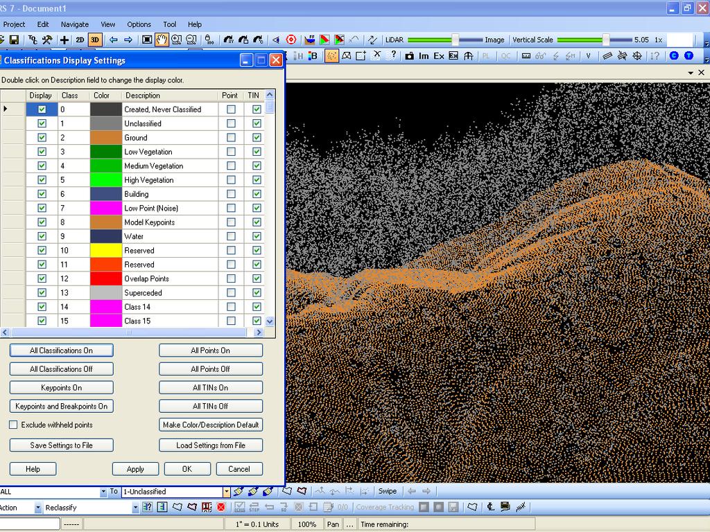
27 LAS Classifications Classification Codes Class 0 Created, never classified 1 Unclassified 2 Ground 3 Low Vegetation 4 Medium Vegetation 5 High Vegetation 6 Building 7 Low Point (noise) 8 Model Key-point (mass point) 9 Water 10 Reserved for ASPRS Definition 11 Reserved for ASPRS Definition 12 Overlap Points Reserved for ASPRS Definition Not reserved currently *Source: LAS Specification, Version 1.1 (
28
29
30
31

32 1. Extract first return LiDAR points 2. Low-pass filter to generalize 3. Polygonize for forest/non-forest layer (red mask)

33 Data Connect to ESRI Grid in AutoCad Civitl 3-D
34
35
36 LiDAR Products for Users Elevation Models (DEMs* or TINs) Relief (Hillshade) Maps * Contour Maps Slope Maps Aspect Maps LAS files for first-return processing*


37 LiDAR Help

38 LiDAR Index
39 LiDAR Applications Watershed Delineation Average Watershed Slope RUSLE2 Slopes Pipeline Profiles Terrace Layout Planning Pond and Structure Stage Storage Wetland Restoration Planning Quantity Estimating Floodplain Management Studies

40 Example: Grade Stabilization Dam Hillshade Rendering of a LiDAR Elevation Model with 1 foot contours and the Drainage Area Proposed Dam Centerline Drainage Area
41 Example: Grade Stabilization Dam Top of Dam Normal Pool Level
42 LiDAR Applications Point Spacing (Meter) Vertical Accuracy (RMSE) (Meter) Contour Interval (Feet) Base Mapping Application Supported Floodplain Mapping Natural Resources Civil Planning Civil Design w/ Limits Note: This table is for example only. Required accuracy for a specific project must be defined on a case-by-case basis.
43 LiDAR Applications Benefits of a Wide Area Coverage Elevation Model: Available on demand. Coverage of entire site. Coverage of land adjacent to site. Can complete planning activities without field surveys.
44
 prohibits discrimination in all its programs and activities on the basis of race, color, national origin, age, disability, and where applicable, sex, marital status,")
45 Helping People Help the Land The U.S. Department of Agriculture (USDA) prohibits discrimination in all its programs and activities on the basis of race, color, national origin, age, disability, and where applicable, sex, marital status, familial status, parental status, religion, sexual orientation, genetic information, political beliefs, reprisal, or because all or a part of an individual's income is derived from any public assistance program. (Not all prohibited bases apply to all programs.) Persons with disabilities who require alternative means for communication of program information (Braille, large print, audiotape, etc.) should contact USDA's TARGET Center at (202) (voice and TDD). To file a complaint of discrimination write to USDA, Director, Office of Civil Rights, 1400 Independence Avenue, S.W., Washington, D.C or call (800) (voice) or (202) (TDD). USDA is an equal opportunity provider and employer.
CRP HEL CRP Ortho Imagery. Tract Cropland Total: acres
 United States Department of Agriculture Madison County, Iowa 17 4.09 23 1.26 6 10.74 14 2.89 12 1.7 1 18.02 230TH LN T 347 3 34 4.65 13 2.81 2 11.4 ELMWOOD AVE 16 3 6.49 18 6.5 1.59 21 2.35 8.76 24 11
Abbreviated 156 Farm Record
 MISSOURI HOWARD Form: FSA-156EZ See Page 3 for non-discriminatory Statements. United States Department of Agriculture Farm Service Agency Abbreviated 156 Farm Record FARM : Prepared : Crop Year : 4825
What is a published soil survey?
 What is a published soil survey? A soil survey is a detailed report on the soils of an area. The soil survey has maps with soil boundaries and photos, descriptions, and tables of soil properties and features.
MATHEWS FARM TUNICA MISSISSIPPI 1130 ACRES (+/ ) TUNICA AND DESOTO COUNTY FOR SALE. List Price $6,100,000.
 TUNICA AND DESOTO COUNTY FOR SALE. List Price $6,100,000.") MATHEWS FARM TUNICA MISSISSIPPI 1130 ACRES (+/ ) TUNICA AND DESOTO COUNTY FOR SALE List Price $6,100,000. FARM ACREAGE BREAKDOWN: Map Acres FSA Crop Acres Shop, bins, turn rows, and ditches Tract 1 Main
MATHEWS FARM TUNICA MISSISSIPPI 1130 ACRES (+/ ) TUNICA AND DESOTO COUNTY FOR SALE List Price $6,100,000. FARM ACREAGE BREAKDOWN: Map Acres FSA Crop Acres Shop, bins, turn rows, and ditches Tract 1 Main
The Wildland Fire Chemical
 United States Department of Agriculture Forest Service Technology & Development Program Airtanker 157-284-MTDC January 21 51/57 Drop Guides Ground Pattern Performance of the National Guard Black Hawk Helicopter
Custom Soil Resource Report for Clackamas County Area, Oregon
 United States Department of Agriculture Natural Resources Conservation Service A product of the National Cooperative Soil Survey, a joint effort of the United States Department of Agriculture and other
Airtanker. Drop Guides
 United States Department of Agriculture Forest Service Technology & Development Program Airtanker 57-2852-MTDC September 2 51/57 Drop Guides Ground Pattern Performance of the Snow Air Tractor with Constant
Custom Soil Resource Report for Multnomah County Area, Oregon
 United States Department of Agriculture Natural Resources Conservation Service A product of the National Cooperative Soil Survey, a joint effort of the United States Department of Agriculture and other
Commentary on Factors Affecting Transverse Vibration Using an Idealized Theoretical Equation
 United States Department of Agriculture Forest Service Forest Products Laboratory Research Note FPL RN 076 Commentary on Factors Affecting Transverse Vibration Using an Idealized Theoretical Equation Joseph
Custom Soil Resource Report for Clackamas County Area, Oregon
 United States Department of Agriculture Natural Resources Conservation Service A product of the National Cooperative Soil Survey, a joint effort of the United States Department of Agriculture and other
Custom Soil Resource Report for Valley County, Montana
 United States Department of Agriculture Natural Resources Conservation Service A product of the National Cooperative Soil Survey, a joint effort of the United States Department of Agriculture and other
Soils of Hawai i Dr. Greg Bruland NREM 461
 Soils of Hawai i Dr. Greg Bruland NREM 461 Figure modified from Gavenda et al. 1998 Island Age = million years (mya) Map modified from Gavenda et al. 1998 Island Age = mya 9 of 11 soil orders present Map
If this is your first experience with LiDAR data you might want to check out the MGISAC s whitepaper on LiDAR here:
 IMPORTANT NOTE! If the LiDAR data products you re looking are not in the maps.wustl.edu / mo_lidar_data directory then it is either not available for public access yet - is in the pipeline to be posted
Near Sledge, Mississippi. Please call to arrange a private viewing
 $3,958,000.00 $1,685,000 ($4,010/Acre) ($3,539/Acre) Precision Leveled Cropland 936.7 Total Acres - 598.39 Cropland Acres - 32.54 CRP Acres - 252.7 Timberland Acres (5) Irrigation Wells CRP Income: $6,500
Custom Soil Resource Report for Clark County, Washington
 United States Department of Agriculture Natural Resources Conservation Service A product of the National Cooperative Soil Survey, a joint effort of the United States Department of Agriculture and other
Esri Image & Mapping Forum 9 July 2017 Geiger-Mode for Conservation Planning & Design by USDA NRCS NGCE
 Esri Image & Mapping Forum 9 July 2017 Geiger-Mode for Conservation Planning & Design by USDA NRCS NGCE For over 75 years, the Natural Resources Conservation Service has been a pioneer in conservation,
Welcome to NR502 GIS Applications in Natural Resources. You can take this course for 1 or 2 credits. There is also an option for 3 credits.
 Welcome to NR502 GIS Applications in Natural Resources. You can take this course for 1 or 2 credits. There is also an option for 3 credits. The 1st credit consists of a series of readings, demonstration,
Total Acres: Tillable Acres: Irrigated Acres: All Improvements will be managed by Farmers National Company / CHS.
 GROUP P Parcel # Acres Twp County FSA Farm FSA Tract Tillable Acres Irrigated Acres 14-040-011-022-00 105.00 Lagrange Cass 7797 7858 262.12 72.50 14-040-011-022-10 5.00 Lagrange Cass 7797 7858 w 040-011-022-00
GIS APPLICATIONS IN SOIL SURVEY UPDATES
 GIS APPLICATIONS IN SOIL SURVEY UPDATES ABSTRACT Recent computer hardware and GIS software developments provide new methods that can be used to update existing digital soil surveys. Multi-perspective visualization
LiDAR Quality Assessment Report
 LiDAR Quality Assessment Report The USGS National Geospatial Technical Operations Center, Data Operations Branch is responsible for conducting reviews of all Light Detection and Ranging (LiDAR) pointcloud
GeoWEPP Tutorial Appendix
 GeoWEPP Tutorial Appendix Chris S. Renschler University at Buffalo - The State University of New York Department of Geography, 116 Wilkeson Quad Buffalo, New York 14261, USA Prepared for use at the WEPP/GeoWEPP
The New York City Soil Survey
 The New York City Soil Survey Olga Vargas, USDA-NRCS Soil Scientist May 2018 New York City Soil Survey Program Since 1995 A partnership was established between: NRCS NYC-SWCD Cornell University To address
160 Acres of Tillable Land, Alfalfa, Pasture, Building Site, and Rec Area in Sun Prairie Township! Thursday, November 1, 2018 at NOON
 160+/- Acres of McCook County land 160 Acres of Tillable Land, Alfalfa, Pasture, Building Site, and Rec Area in Sun Prairie Township! Thursday, November 1, 2018 at NOON Located from Salem, SD on US HWY
NR402 GIS Applications in Natural Resources
 NR402 GIS Applications in Natural Resources Lesson 1 Introduction to GIS Eva Strand, University of Idaho Map of the Pacific Northwest from http://www.or.blm.gov/gis/ Welcome to NR402 GIS Applications in
2013 Indiana GIS Conference. Mini-Workshop. (9:00 am 10:30 am)
") Indiana GIS LiDAR Applications 2013 Indiana GIS Conference Mini-Workshop May 7, 2013 (9:00 am 10:30 am) Topics Workshop Overview 1. Indiana Statewide Ortho-LiDAR Program Overview and Status (Phil Worrall)
Indiana GIS LiDAR Applications 2013 Indiana GIS Conference Mini-Workshop May 7, 2013 (9:00 am 10:30 am) Topics Workshop Overview 1. Indiana Statewide Ortho-LiDAR Program Overview and Status (Phil Worrall)
Custom Soil Resource Report for Bell County, Texas
 United States Department of Agriculture Natural Resources Conservation Service A product of the National Cooperative Soil Survey, a joint effort of the United States Department of Agriculture and other
Custom Soil Resource Report for St. Lucie County, Florida
 United States Department of Agriculture Natural Resources Conservation Service A product of the National Cooperative Soil Survey, a joint effort of the United States Department of Agriculture and other
LiDAR User Data Needs Survey Results
 LiDAR User Data Needs Survey Results June 2012 Introduction The Minnesota Geospatial Information Office (MnGeo) is working with the Minnesota Department of Natural Resources (DNR) to develop a data distribution
Remote Sensing / GIS Conference. The Louisiana Proposed Elevation for the Nation Business Plan Components
 Remote Sensing / GIS Conference 08 April 2008 The Louisiana Proposed Elevation for the Nation Business Plan Components David Gisclair, Louisiana Oil Spill Coordinators Office, Office of the Governor david.gisclair@la.gov
GRAPEVINE LAKE MODELING & WATERSHED CHARACTERISTICS
 GRAPEVINE LAKE MODELING & WATERSHED CHARACTERISTICS Photo Credit: Lake Grapevine Boat Ramps Nash Mock GIS in Water Resources Fall 2016 Table of Contents Figures and Tables... 2 Introduction... 3 Objectives...
Equal Employment Opportunity Data Posted Pursuant to the No Fear Act: Army (and below)
") Equal Employment Opportunity Data Posted Pursuant to the No Fear Act: Army (and below) For 4th Quarter 2013 for period ending September, 2013 **This report is based on the Complaint Against hierarchy.**
Equal Employment Opportunity Data Posted Pursuant to the No Fear Act: Army (and below) For 4th Quarter 2013 for period ending September, 2013 **This report is based on the Complaint Against hierarchy.**
Key Processes
 Data Manipulation and Extraction Key Processes Key Processes Re-Projecting Data Selecting by Attributes Exporting Data Hillshade Reclassification Conversion of Raster to Vector Re-Projecting Data Purpose
Workshops funded by the Minnesota Environment and Natural Resources Trust Fund
 Workshops funded by the Minnesota Environment and Natural Resources Trust Fund Conservation Applications of LiDAR Data Workshops funded by: Minnesota Environment and Natural Resources Trust Fund Presented
Geospatial Data, Services, and Products. National Surveying, mapping and geospatial conference
 Geospatial Data, Services, and Products Federal Programs -- USDA NRCS National Surveying, mapping and geospatial conference March 15, 2016 NRCS Applications using Geosaptial Products & Services Field
Introduction. Elevation Data Strategy. Status and Next Steps
 1 2 Introduction Elevation Data Strategy Status and Next Steps 3 Canada is the 2nd largest country in the world - 9.9 million sq km Surrounded by 3 oceans with 202 000 km of coastline Population over 35
MISSOURI LiDAR Stakeholders Meeting
 MISSOURI LiDAR Stakeholders Meeting East-West Gateway June 18, 2010 Tim Haithcoat Missouri GIO Enhanced Elevation Data What s different about it? Business requirements are changing.fast New data collection
YELLOW MEDICINE COUNTY FARMS FOR SALE
 YELLOW MEDICINE COUNTY FARMS FOR SALE Owners Rhea Trusts 790+ acres of high quality cropland in western Yellow Medicine County, MN. The land has been owned by the Rhea family for many years. The land includes
Summary Description Municipality of Anchorage. Anchorage Coastal Resource Atlas Project
 Summary Description Municipality of Anchorage Anchorage Coastal Resource Atlas Project By: Thede Tobish, MOA Planner; and Charlie Barnwell, MOA GIS Manager Introduction Local governments often struggle
Waterborne Environmental, Inc., Leesburg, VA, USA 2. Syngenta Crop Protection, LLC, North America 3. Syngenta Crop Protection, Int.
 Application of High Resolution Elevation Data (LiDAR) to Assess Natural and Anthropogenic Agricultural Features Affecting the Transport of Pesticides at Multiple Spatial Scales Josh Amos 1, Chris Holmes
Tim Loesch Minnesota Department of Natural Resources
 Tim Loesch Minnesota Department of Natural Resources Agenda Status of State Project Where to get data What types of data are available How to download and retrieve information What to do after you download
U. S. Postal Service
 U. S. Postal Service Equal Employment Opportunity Data Posted Pursuant to Title III of the Notification and Federal Employee Antidiscrimination and Retaliation Act of 2002 (No FEAR Act), Public Law 107-174
Western Area U. S. Postal Service
 Western Area U. S. Postal Service Equal Employment Opportunity Data Posted Pursuant to Title III of the Notification and Federal Employee Antidiscrimination and Retaliation Act of 2002 (No FEAR Act), Public
Eastern Area U. S. Postal Service
 Eastern Area U. S. Postal Service Equal Employment Opportunity Data Posted Pursuant to Title III of the Notification and Federal Employee Antidiscrimination and Retaliation Act of 2002 (No FEAR Act), Public
Great Lakes Area U. S. Postal Service
 Great Lakes Area U. S. Postal Service Equal Employment Opportunity Data Posted Pursuant to Title III of the Notification and Federal Employee Antidiscrimination and Retaliation Act of 2002 (No FEAR Act),
Northeast Area U. S. Postal Service
 Northeast Area U. S. Postal Service Equal Employment Opportunity Data Posted Pursuant to Title III of the Notification and Federal Employee Antidiscrimination and Retaliation Act of 2002 (No FEAR Act),
Capital Metro Area U. S. Postal Service
 Capital Metro Area U. S. Postal Service Equal Employment Opportunity Data Posted Pursuant to Title III of the Notification and Federal Employee Antidiscrimination and Retaliation Act of 2002 (No FEAR Act),
Object Based Imagery Exploration with. Outline
 Object Based Imagery Exploration with Dan Craver Portland State University June 11, 2007 Outline Overview Getting Started Processing and Derivatives Object-oriented classification Literature review Demo
EXPERIENCE WITH HIGH ACCURACY COUNTY DTM MAPPING USING SURVEYING, PHOTOGRAMMETRIC, AND LIDAR TECHNOLOGIES - GOVERNMENT AND CONTRACTOR PERSPECTIVES
 EXPERIENCE WITH HIGH ACCURACY COUNTY DTM MAPPING USING SURVEYING, PHOTOGRAMMETRIC, AND LIDAR TECHNOLOGIES - GOVERNMENT AND CONTRACTOR PERSPECTIVES Barbora Ubar, Photogrammetrist Tim Brown, PSM, Senior
Equal Employment Opportunity Data Posted Pursuant to the No Fear Act: Army (and below)
") Equal Employment Opportunity Data Posted Pursuant to the No Fear Act: Army (and below) For 4th Quarter 2016 for period ending September, 2016 **This report is based on the Complaint Against hierarchy.**
Equal Employment Opportunity Data Posted Pursuant to the No Fear Act: Army (and below) For 4th Quarter 2016 for period ending September, 2016 **This report is based on the Complaint Against hierarchy.**
StreamStats: Delivering Streamflow Information to the Public. By Kernell Ries
 StreamStats: Delivering Streamflow Information to the Public By Kernell Ries U.S. Department of the Interior U.S. Geological Survey MD-DE-DC District 410-238-4317 kries@usgs.gov StreamStats Web Application
Equal Employment Opportunity Data Posted Pursuant to the No FEAR Act
 Page 1 of 7 U. S. Postal Service Equal Employment Opportunity Data Posted Pursuant to Title III of the Notification and Federal Employee Antidiscrimination and Retaliation Act of 2002 (No FEAR Act), Public
Custom Soil Resource Report for San Juan Area, Puerto Rico
 United States Department of Agriculture Natural Resources Conservation Service A product of the National Cooperative Soil Survey, a joint effort of the United States Department of Agriculture and other
Equal Employment Opportunity Data Posted Pursuant to the No FEAR Act
 Page 1 of 7 Eastern Area U. S. Postal Service Equal Employment Opportunity Data Posted Pursuant to Title III of the Notification and Federal Employee Antidiscrimination and Retaliation Act of 2002 (No
Custom Soil Resource Report for Polk County, Oregon
 United States Department of Agriculture Natural Resources Conservation Service A product of the National Cooperative Soil Survey, a joint effort of the United States Department of Agriculture and other
Watershed Delineation
 Watershed Delineation Jessica L. Watkins, University of Georgia 2 April 2009 Updated by KC Love February 25, 2011 PURPOSE For this project, I delineated watersheds for the Coweeta synoptic sampling area
EO Information Services. Assessing Vulnerability in the metropolitan area of Rio de Janeiro (Floods & Landslides) Project
 Project") EO Information Services in support of Assessing Vulnerability in the metropolitan area of Rio de Janeiro (Floods & Landslides) Project Ricardo Armas, Critical Software SA Haris Kontoes, ISARS NOA World
EO Information Services in support of Assessing Vulnerability in the metropolitan area of Rio de Janeiro (Floods & Landslides) Project Ricardo Armas, Critical Software SA Haris Kontoes, ISARS NOA World
Field Indicators of Inlet Controlled Road Stream Crossing Capacity
 D E P A RTMENT OF AGRICUL E TU R United States Department of Agriculture Forest Service Technology & Development Program 7700 Transportation System 2500 Watershed and Air Management October 1997 9777 1807
Flood Hazard Zone Modeling for Regulation Development
 Flood Hazard Zone Modeling for Regulation Development By Greg Lang and Jared Erickson Pierce County GIS June 2003 Abstract The desire to blend current digital information with government permitting procedures,
Capital Metro Area U. S. Postal Service
 Capital Metro Area U. S. Postal Service Equal Employment Opportunity Data Posted Pursuant to Title III of the Notification and Federal Employee Antidiscrimination and Retaliation Act of 2002 (No FEAR Act),
Pacific Area U. S. Postal Service
 Pacific Area U. S. Postal Service Equal Employment Opportunity Data Posted Pursuant to Title III of the Notification and Federal Employee Antidiscrimination and Retaliation Act of 2002 (No FEAR Act), Public
Custom Soil Resource Report for Santa Fe Area, New Mexico, Santa Fe County and Part of Rio Arriba County; and Santa Fe County Area, New Mexico
 United States Department of Agriculture Natural Resources Conservation Service A product of the National Cooperative Soil Survey, a joint effort of the United States Department of Agriculture and other
Hydrology and Watershed Analysis
 Hydrology and Watershed Analysis Manual By: Elyse Maurer Reference Map Figure 1. This map provides context to the area of Washington State that is being focused on. The red outline indicates the boundary
 United States Department of Agriculture Natural Resources Conservation Service A product of the National Cooperative Soil Survey, a joint effort of the United States Department of Agriculture and other
IMPERIAL COUNTY PLANNING AND DEVELOPMENT
 IMPERIAL COUNTY PLANNING AND DEVELOPMENT GEODATABASE USER MANUAL FOR COUNTY BUSINESS DEVELOPMENT GIS June 2010 Prepared for: Prepared by: County of Imperial Planning and Development 801 Main Street El
Erin Costello A comparison of Solar Radiation Modeling Tools
 Erin Costello A comparison of Solar Radiation Modeling Tools The Oregon Department of Environmental Quality uses effective shade as an indicator of water quality parameters as well as a target for restoration
Base Level Engineering FEMA Region 6
 Base Level Engineering Over the past five years, has been evaluating its investment approach and data preparation work flow to establish an efficient and effective change in operation, generating an approach
Evaluating Digital Meters for Fire Weather Observations. Greg Lemon, Project Assistant; and Dick Mangan, Program Leader
 Fire Tech Tips United States Department of Agriculture Forest Service Technology & Development Program June 2000 5100 0051-2315 MTDC Evaluating Digital Meters for Fire Weather Observations Greg Lemon,
Hydrologic Engineering Applications of Geographic Information Systems
 Hydrologic Engineering Applications of Geographic Information Systems Davis, California Objectives: The participant will acquire practical knowledge and skills in the application of GIS technologies for
Custom Soil Resource Report for Okeechobee County, Florida
 United States Department of Agriculture Natural Resources Conservation Service A product of the National Cooperative Soil Survey, a joint effort of the United States Department of Agriculture and other
Crop Progress. Corn Mature Selected States [These 18 States planted 92% of the 2017 corn acreage]
![Crop Progress. Corn Mature Selected States [These 18 States planted 92% of the 2017 corn acreage]](/thumbs/89/98128758.jpg "Crop Progress. Corn Mature Selected States [These 18 States planted 92% of the 2017 corn acreage]") Crop Progress ISSN: 00 Released October, 0, by the National Agricultural Statistics Service (NASS), Agricultural Statistics Board, United s Department of Agriculture (USDA). Corn Mature Selected s [These
Crop Progress ISSN: 00 Released October, 0, by the National Agricultural Statistics Service (NASS), Agricultural Statistics Board, United s Department of Agriculture (USDA). Corn Mature Selected s [These
What s New in Topographic Information - USGS National Map
 + What s New in Topographic Information - USGS National Map SARGIS Workshop November 14, 2016 Rob Dollison, 703-648-5724 rdollison@usgs.gov + USGS 2 National Geospatial Program The National Geospatial
Pierce Cedar Creek Institute GIS Development Final Report. Grand Valley State University
 Pierce Cedar Creek Institute GIS Development Final Report Grand Valley State University Major Goals of Project The two primary goals of the project were to provide Matt VanPortfliet, GVSU student, the
Custom Soil Resource Report for Clackamas County Area, Oregon
 United States Department of Agriculture Natural Resources Conservation Service A product of the National Cooperative Soil Survey, a joint effort of the United States Department of Agriculture and other
METADATA. Publication Date: Fiscal Year Cooperative Purchase Program Geospatial Data Presentation Form: Map Publication Information:
 METADATA CONTOURS Digital Geospatial Metadata: North Central Texas Orthophotography Identification Information Citation Originator: Publication Date: Fiscal Year 2001-2002 Title: Cooperative Purchase Program
Custom Soil Resource Report for Clackamas County Area, Oregon
 United States Department of Agriculture Natural Resources Conservation Service A product of the National Cooperative Soil Survey, a joint effort of the United States Department of Agriculture and other
Potential Restorable Wetlands (PRWs):
:") ASWM Webinar Sept. 17, 2014 Potential Restorable Wetlands (PRWs): Working definition: wetland hydrology and soils minus presently mapped wetlands for the re-establishment of wetlands Hydric Soil Query
ASWM Webinar Sept. 17, 2014 Potential Restorable Wetlands (PRWs): Working definition: wetland hydrology and soils minus presently mapped wetlands for the re-establishment of wetlands Hydric Soil Query
4. GIS Implementation of the TxDOT Hydrology Extensions
 4. GIS Implementation of the TxDOT Hydrology Extensions A Geographic Information System (GIS) is a computer-assisted system for the capture, storage, retrieval, analysis and display of spatial data. It
Geographic Information Systems. Introduction to Data and Data Sources
 Geographic Information Systems Introduction to Data and Data Sources Presented by John Showler, NJDA-SSCC NJ SCD GIS Training Session December 10, 209 The Objectives of this session are 3-fold: 1. Introduce
Presented by: Ki r k Cont r ucci, CP Ayres Associates. Andy Faust, GISP North Central Wisconsin Regional Planning Commission.
 Andy Faust, GISP North Central Wisconsin Regional Planning Commission Presented by: Ki r k Cont r ucci, CP Ayres Associates Zach Nienow Ayres Associates Adam Derringer, GISP Ayres Associates Type questions
Yaneev Golombek, GISP. Merrick/McLaughlin. ESRI International User. July 9, Engineering Architecture Design-Build Surveying GeoSpatial Solutions
 Yaneev Golombek, GISP GIS July Presentation 9, 2013 for Merrick/McLaughlin Conference Water ESRI International User July 9, 2013 Engineering Architecture Design-Build Surveying GeoSpatial Solutions Purpose
Custom Soil Resource Report for Marion County Area, Oregon
 United States Department of Agriculture Natural Resources Conservation Service A product of the National Cooperative Soil Survey, a joint effort of the United States Department of Agriculture and other
A Help Guide for Using gssurgo to Find Potential Wetland Soil Landscapes
 A Help Guide for Using gssurgo to Find Potential Wetland Soil Landscapes Wetland Mapping Consortium Webinar September 17, 2014 Dr. John M. Galbraith Crop & Soil Environmental Sciences Virginia Tech Wetland
LIDAR: Statutory Compliance Benefits for Nebraska Natural Resources
 LIDAR: Statutory Compliance Benefits for Nebraska Natural Resources 2011 Nebraska GIS Symposium La Vista, NE April 21, 2011 Doug Hallum, P.G. Integrated Water Management Coordinator Nebraska Department
1 Introduction: 2 Data Processing:
 Darren Janzen University of Northern British Columbia Student Number 230001222 Major: Forestry Minor: GIS/Remote Sensing Produced for: Geography 413 (Advanced GIS) Fall Semester Creation Date: November
New Land Cover & Land Use Data for the Chesapeake Bay Watershed
 New Land Cover & Land Use Data for the Chesapeake Bay Watershed Why? The Chesapeake Bay Program (CBP) partnership is in the process of improving and refining the Phase 6 suite of models used to inform
Equal Employment Opportunity Data Posted Pursuant to the No Fear Act: Army (and below)
") Content Body Navigation Links Connect Portal MicroPact icomplaints System Session will expire in 30 minutes Thu Jan 31 06:51:39 GMT 2019 Report Filter/Options Exit NoFear Module Equal Employment Opportunity
Content Body Navigation Links Connect Portal MicroPact icomplaints System Session will expire in 30 minutes Thu Jan 31 06:51:39 GMT 2019 Report Filter/Options Exit NoFear Module Equal Employment Opportunity
Custom Soil Resource Report for Livingston Parish, Louisiana
 United States Department of Agriculture Natural Resources Conservation Service A product of the National Cooperative Soil Survey, a joint effort of the United States Department of Agriculture and other
Model Implementation Details for the Final Project in EEOS 465/
 Model Implementation Details for the Final Project in EEOS 465/627 2009 Last week, we introduced a conceptual model of estimating DOC loadings from landscape to coastal waters as a model template for the
Web (Java, ArcGIS Server [WebADF, flex, silverlight]) Mobile (ArcGIS Mobile, ArcPad, Windows Mobile) Deskt
![Web (Java, ArcGIS Server [WebADF, flex, silverlight]) Mobile (ArcGIS Mobile, ArcPad, Windows Mobile) Deskt](/thumbs/96/129284052.jpg "Web (Java, ArcGIS Server [WebADF, flex, silverlight]) Mobile (ArcGIS Mobile, ArcPad, Windows Mobile) Deskt") GIS Services company in Lincoln, NE Custom GIS database design and build (for local, county, state and private corporations) Custom (ESRI and non-esri) application design and build in Java, C++, C#,.Net
GIS Services company in Lincoln, NE Custom GIS database design and build (for local, county, state and private corporations) Custom (ESRI and non-esri) application design and build in Java, C++, C#,.Net
Evaluating Urban Vegetation Cover Using LiDAR and High Resolution Imagery
 Evaluating Urban Vegetation Cover Using LiDAR and High Resolution Imagery Y.A. Ayad and D. C. Mendez Clarion University of Pennsylvania Abstract One of the key planning factors in urban and built up environments
ISO Swift Current LiDAR Project 2009 Data Product Specifications. Revision: A
 ISO 19131 Swift Current LiDAR Project 2009 Data Product Specifications Revision: A Data product specifications: Swift Current LiDAR Project 2009 - Table of Contents- 1. Overview... 4 1.1. Informal description...
Custom Soil Resource Report for Clackamas County Area, Oregon, and Marion County Area, Oregon
 United States Department of Agriculture Natural Resources Conservation Service A product of the National Cooperative Soil Survey, a joint effort of the United States Department of Agriculture and other
GIS Techniques for Floodplain Delineation. Dean Djokic
 GIS Techniques for Floodplain Delineation Dean Djokic (ddjokic@esri.com) Content What is a floodplain? How to get a floodplain? What can GIS do for floodplain modeling? Simple GIS techniques for floodplain
08/01/2012. LiDAR. LiDAR Benefits. LiDAR-BASED DELINEATION OF WETLAND BORDERS. CCFFR-2012 Society for Canadian Limnologists:
 LiDAR CCFFR-2012 Society for Canadian Limnologists: Science for Wetland Policy and Management LiDAR-BASED DELINEATION OF WETLAND BORDERS Distance from laser to ground and back again: Determined as laser-pulse
The Future of Soil Mapping using LiDAR Technology
 The Future of Soil Mapping using LiDAR Technology Jessica Philippe Soil Scientist/GIS Specialist March 24, 2016 Natural Resources Conservation Service Helping People Help the Land Area 12-STJ covers parts
Introduction INTRODUCTION TO GIS GIS - GIS GIS 1/12/2015. New York Association of Professional Land Surveyors January 22, 2015
 New York Association of Professional Land Surveyors January 22, 2015 INTRODUCTION TO GIS Introduction GIS - GIS GIS 1 2 What is a GIS Geographic of or relating to geography the study of the physical features
ELEVATION. The Base Map
 ELEVATION The Base Map Basic Elevation Types: Points X, Y, Z Irregular distribution Cumbersome Typical sources Lidar Stereo photography Ground survey ASCII, LAS formats Basic Elevation Types: Contour Lines
Introduction-Overview. Why use a GIS? What can a GIS do? Spatial (coordinate) data model Relational (tabular) data model
 data model Relational (tabular) data model") Introduction-Overview Why use a GIS? What can a GIS do? How does a GIS work? GIS definitions Spatial (coordinate) data model Relational (tabular) data model intro_gis.ppt 1 Why use a GIS? An extension
Introduction-Overview Why use a GIS? What can a GIS do? How does a GIS work? GIS definitions Spatial (coordinate) data model Relational (tabular) data model intro_gis.ppt 1 Why use a GIS? An extension
Providing Public Access to King County GIS Data. Presented by: Michael Jenkins King County GIS Center Seattle, WA
 Providing Public Access to King County GIS Data Presented by: Michael Jenkins King County GIS Center Seattle, WA King County, Washington Microsoft Boeing Amazon.Com Starbucks Port of Seattle Weyerhauser
Lidar-derived Hydrography as a Source for the National Hydrography Dataset
 Lidar-derived Hydrography as a Source for the National Hydrography Dataset Lidar-Derived Hydrography, Bathymetry, and Topobathymetry in the National Hydrography Dataset and 3-Dimensional Elevation Program