Soils of Hawai i Dr. Greg Bruland NREM 461
|
|
|
- Sibyl Harrison
- 5 years ago
- Views:
Transcription


1 Soils of Hawai i Dr. Greg Bruland NREM 461
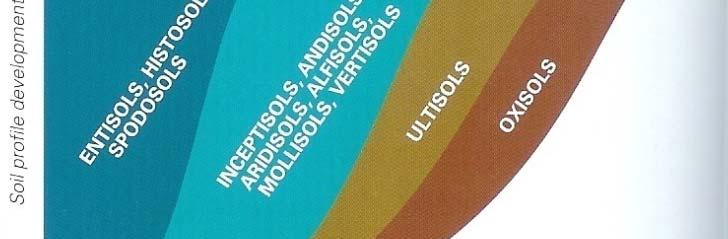
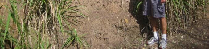
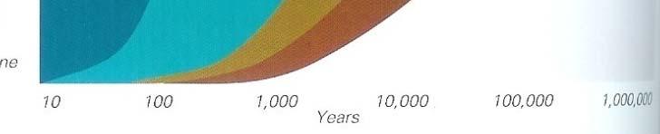
2 Figure modified from Gavenda et al. 1998


3 Island Age = million years (mya) Map modified from Gavenda et al. 1998


4 Island Age = mya 9 of 11 soil orders present Map modified from Gavenda et al. 1998


5 Island Age = mya Map modified from Gavenda et al. 1998
6 Island Age = mya Map modified from Gavenda et al. 1998


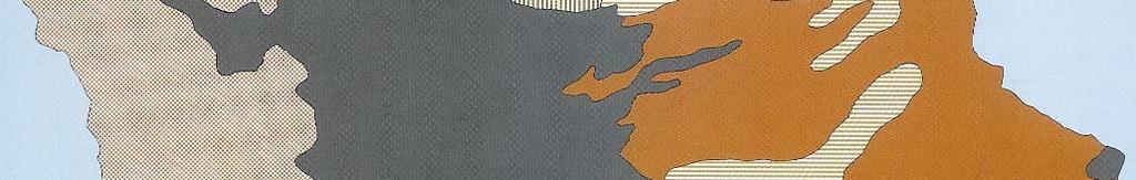


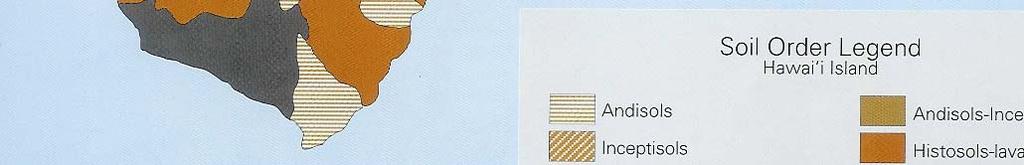
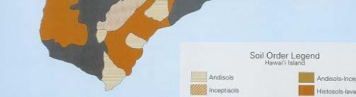
7 Hawai i Island sa Age = mya Map modified from Gavenda et al. 1998


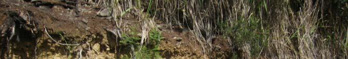
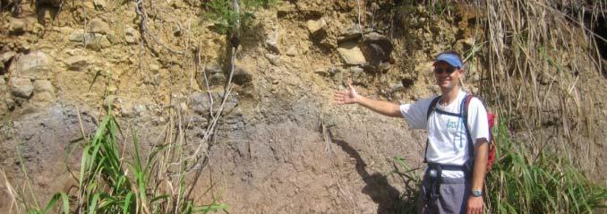
8 HILO -- HAWAII STATE SOIL Hilo soils have historically been used for sugarcane crops. With the decline of the sugar industry, there has been a shift toward truck crops, such as ginger and taro; orchard crops, such as macadamia and papaya; and forestry. These soils cover about 14,500 acres and are considered prime agricultural land. The Hawaiian definition of the word Hilo is first night of the full moon. Also, the word is the Polynesian term for Navigator. The Hilo series consists of very deep, moderately well drained soils that formed in many layers of volcanic ash with lesser amounts of dust from the deserts of central Asia. These dust layers are noticeable because their gray color contrasts with the dark brown and dark reddish brown subsoil formed in volcanic ash. There are several buried layers within the Hilo soil profile. Hilo soils occur on the uplands of the Mauna Kea volcano along the Hamakua Coast. Hilo Soil Profile Surface layer: dark brown silty clay loam Subsoil: dark reddish brown, dark grayish brown, and dark brown silty clay loam The U.S. Department of Agriculture (USDA) prohibits discrimination in all its programs and activities on the basis of race, color, national origin, gender, religion, age, disability, political beliefs, sexual orientation, and marital or family status. (Not all prohibited bases apply to all programs.) Persons with disabilities who require alternative means for communication of program information (Braille, large print, audiotape, etc.) should contact USDA s TARGET Center at (voice and TDD). To file a complaint of discrimination, write USDA, Director, Office of Civil Rights, Room 326W, Whitten Building, 14th and Independence Avenue, SW, Washington, DC or call (voice or TDD). USDA is an equal opportunity provider and employer.
9 Island of Kauai ALISH Prime Unique Hanalei Other Major Roads Kapaa Waimea Lihue This map was produced by the Office of Planning (OP) for planning purposes. It should not be used for boundary interpretations or other spatial analysis beyond the limitations of the data. Information regarding compilation dates and accuracy of the data presented can be obtained from OP. Sources: ALISH (Agricultural Lands of Importance to the State of Hawaii) - State Dept. of Agriculture, Major Roads - USGS, Hanapepe Poipu Miles
10 Miles Haleiwa Kahuku Island of Oahu ALISH Prime Unique Other Major Roads Wahiawa Waianae Mililani Pearl City Kaneohe Kailua Nanakuli Kapolei This map was produced by the Office of Planning (OP) for planning purposes. It should not be used for boundary interpretations or other spatial analysis beyond the limitations of the data. Information regarding compilation dates and accuracy of the data presented can be obtained from OP. Sources: ALISH (Agricultural Lands of Importance to the State of Hawaii) - State Dept. of Agriculture, Major Roads - USGS, HONOLULU
11 Molokai Kaluakoi Kalaupapa Kualapuu Maunaloa Kaunakakai Ualapue Islands of Molokai and Lanai ALISH Lanai Prime Unique Other Major Roads Lanai City This map was produced by the Office of Planning (OP) for planning purposes. It should not be used for boundary interpretations or other spatial analysis beyond the limitations of the data. Information regarding compilation dates and accuracy of the data presented can be obtained from OP. Sources: ALISH (Agricultural Lands of Importance to the State of Hawaii) - State Dept. of Agriculture, Major Roads - USGS, Manele Bay Miles
12 Island of Maui ALISH Major Roads Prime Kahului Unique Other Lahaina Wailuku Pukalani Hana Kihei Kula Haleakala Miles Wailea This map was produced by the Office of Planning (OP) for planning purposes. It should not be used for boundary interpretations or other spatial analysis beyond the limitations of the data. Information regarding compilation dates and accuracy of the data presented can be obtained from OP. Sources: ALISH (Agricultural Lands of Importance to the State of Hawaii) - State Dept. of Agriculture, Major Roads - USGS, 1983.
13 Honokaa Island of Hawaii ALISH Prime Kawaihae Waimea Unique Other Major Roads Mauna Kea Hilo Kailua- Kona Keaau Mauna Loa Volcano Naalehu This map was produced by the Office of Planning (OP) for planning purposes. It should not be used for boundary interpretations or other spatial analysis beyond the limitations of the data. Information regarding compilation dates and accuracy of the data presented can be obtained from OP Miles Sources: ALISH (Agricultural Lands of Importance to the State of Hawaii) - State Dept. of Agriculture, Major Roads - USGS, 1983.

14 Miles Niihau Kauai Oahu Molokai Maui State of Hawaii ALISH Prime Unique Other Major Roads Lanai Kahoolawe Hawaii This map was produced by the Office of Planning (OP) for planning purposes. It should not be used for boundary interpretations or other spatial analysis beyond the limitations of the data. Information regarding compilation dates and accuracy of the data presented can be obtained from OP. Sources: ALISH (Agricultural Lands of Importance to the State of Hawaii) - State Dept. of Agriculture, Major Roads - USGS, 1983.
What is a published soil survey?
 What is a published soil survey? A soil survey is a detailed report on the soils of an area. The soil survey has maps with soil boundaries and photos, descriptions, and tables of soil properties and features.
Abbreviated 156 Farm Record
 MISSOURI HOWARD Form: FSA-156EZ See Page 3 for non-discriminatory Statements. United States Department of Agriculture Farm Service Agency Abbreviated 156 Farm Record FARM : Prepared : Crop Year : 4825
CRP HEL CRP Ortho Imagery. Tract Cropland Total: acres
 United States Department of Agriculture Madison County, Iowa 17 4.09 23 1.26 6 10.74 14 2.89 12 1.7 1 18.02 230TH LN T 347 3 34 4.65 13 2.81 2 11.4 ELMWOOD AVE 16 3 6.49 18 6.5 1.59 21 2.35 8.76 24 11
Management and Use of LiDAR-derived Information. Elizabeth Cook, GIS Specialist
 Management and Use of LiDAR-derived Information Elizabeth Cook, GIS Specialist Advanced LiDAR Workshop March 15, 2012 50-100 gb/county Now What? Project Deliverables LAS mass point files, classification
Department of Education WSF Allocation Summary for FY10-11 OFFICIAL ENROLLMENT based on FINAL Appropriation and OFFICIAL Enrollment
 WSF Allocation Summary for FY0- OFFICIAL ENROLLMENT () (2) (3) (4) (5) (6) (7) (8) (9) (0) FY 0- WSF Calculation based on Official Enrollment FY0- FY 0- WSF OEC ALLOC 0 06 FARRINGTON HIGH H 9,80,534 0
MATHEWS FARM TUNICA MISSISSIPPI 1130 ACRES (+/ ) TUNICA AND DESOTO COUNTY FOR SALE. List Price $6,100,000.
 TUNICA AND DESOTO COUNTY FOR SALE. List Price $6,100,000.") MATHEWS FARM TUNICA MISSISSIPPI 1130 ACRES (+/ ) TUNICA AND DESOTO COUNTY FOR SALE List Price $6,100,000. FARM ACREAGE BREAKDOWN: Map Acres FSA Crop Acres Shop, bins, turn rows, and ditches Tract 1 Main
MATHEWS FARM TUNICA MISSISSIPPI 1130 ACRES (+/ ) TUNICA AND DESOTO COUNTY FOR SALE List Price $6,100,000. FARM ACREAGE BREAKDOWN: Map Acres FSA Crop Acres Shop, bins, turn rows, and ditches Tract 1 Main
SCHOOL YEAR OFFICAL
 8 9 10 11 12 13 1 1 1 1 18 19 20 21 22 23 2 2 2 2 28 29 30 31 32 33 3 3 3 3 38 39 0 1 2 3 8 9 0 1 2 3 8 9 0 1 2 3 A B D EF G K O P S X Y ZA AB AF AJ AK AN AS AT AU AA AX AY AZ BA BB BC BB BG BH BI BJ BK
Department of Education SY12-13 Summary of PROJECTED Demographics for WSF Financial Plan Calculation
 A B D EF G K O P S X Y ZA AB AF AJ AK AN AS AT AU AA AX AY AZ BA BB BC BB BG BH BI BJ BK B 2012-13 YEAR PROJECTED ENROLLMENT COUNTS (1) (2) () () (11) (1) (1) (19) (2) (2) (28) (32) (3) (3) (0) () () ()
Department of Education SY08-09 Summary of Demographics for WSF
 6 7 8 9 0 2 6 7 8 9 20 2 22 2 2 2 26 27 28 29 0 2 6 7 8 9 0 2 6 7 8 9 0 2 6 7 8 9 60 6 62 6 A B C D H S T UV Z AA AB AC AA AF AG AH AI AJ AK AA AO AP AQ AR AS AA 2008-09 YEAR PROJECTED MENT COUNTS GEN
The Wildland Fire Chemical
 United States Department of Agriculture Forest Service Technology & Development Program Airtanker 157-284-MTDC January 21 51/57 Drop Guides Ground Pattern Performance of the National Guard Black Hawk Helicopter
Department of Education SY08-09 Summary of Demographics for WSF
 8 9 10 11 12 1 1 1 1 1 18 19 20 21 22 2 2 2 2 2 28 29 0 1 2 8 9 0 1 2 8 9 0 1 2 8 9 0 1 2 A B C DE F G K O P S X Y ZA AB AC AG AK AL AO AT AU AV AA AY AZ BA BB BC BD BB BH BI BJ BK BL BB BW BX BY BZ 2008-09
Graded Assignment SCI113A: Earth Science Unit 2 Lesson 9: Discuss: Island Chain Formation
 Name: Date: Graded Assignment Lab Report Use Questions 1 4 to help you form your hypothesis. Then, use the data to test your hypothesis and answer Questions 5 10 to help you evaluate your hypothesis. Be
Safety and Wellness Survey Data Report for School Year
 Safety and Wellness Survey Data Report for School Year 2012-13 This report describes each school s progress in meeting the Hawaii State Department of Education Wellness Guidelines using data from the Safety
Commentary on Factors Affecting Transverse Vibration Using an Idealized Theoretical Equation
 United States Department of Agriculture Forest Service Forest Products Laboratory Research Note FPL RN 076 Commentary on Factors Affecting Transverse Vibration Using an Idealized Theoretical Equation Joseph
Department of Education SY09-10 Summary of PROJECTED Demographics for WSF Financial Plan Calculation
 Department of Education 3 A B C DE F G K O P S X Y ZA AB AC AG AK AL AO AT AU AV AA AY AZ BA BB BC BD BB BH BI BJ BK BL B 2009-10 YEAR OFFICIAL ENROLLMENT COUNTS GEN ED ENROLL * SPED ENROLL ENROLLMENT
Airtanker. Drop Guides
 United States Department of Agriculture Forest Service Technology & Development Program Airtanker 57-2852-MTDC September 2 51/57 Drop Guides Ground Pattern Performance of the Snow Air Tractor with Constant
TOTAL SPED K-12 PRE-K SPED K
 3 Department of Education SY201-2018 Summary of PROJECTED Demographics for WSF Financial Plan Calculation A B D EF G K O P S X Y ZA AB AF AJ AK AN AS AT AU AA AX AY AZ BA BB BC BB BG BH BI BJ BK B 201-18
Near Sledge, Mississippi. Please call to arrange a private viewing
 $3,958,000.00 $1,685,000 ($4,010/Acre) ($3,539/Acre) Precision Leveled Cropland 936.7 Total Acres - 598.39 Cropland Acres - 32.54 CRP Acres - 252.7 Timberland Acres (5) Irrigation Wells CRP Income: $6,500
160 Acres of Tillable Land, Alfalfa, Pasture, Building Site, and Rec Area in Sun Prairie Township! Thursday, November 1, 2018 at NOON
 160+/- Acres of McCook County land 160 Acres of Tillable Land, Alfalfa, Pasture, Building Site, and Rec Area in Sun Prairie Township! Thursday, November 1, 2018 at NOON Located from Salem, SD on US HWY
SCHOOL YEAR OFFICAL
 8 9 10 11 12 13 1 1 1 1 18 19 20 21 22 23 2 2 2 2 28 29 30 31 32 33 3 3 3 3 38 39 0 1 2 3 8 9 0 1 2 3 8 9 0 1 2 3 A B D EF G K O P S X Y ZA AB AF AJ AK AN AS AT AU AA AX AY AZ BA BB BC BB BG BH BI BJ BK
Custom Soil Resource Report for Multnomah County Area, Oregon
 United States Department of Agriculture Natural Resources Conservation Service A product of the National Cooperative Soil Survey, a joint effort of the United States Department of Agriculture and other
Adaptive Radiations. Hawaiian archipelago - the example for adaptive radiations. for adaptive radiations. for adaptive radiations
 Adaptive Radiations We will examine adaptive radiations in the context of the Hawaiian Islands Hawaiian archipelago - the example for adaptive radiations Getting there is half the problem...but then they
Total District 01 Diamond Head 1,298.39
 Ordinary Income/Expense Income Contributions Income District 01 Diamond Head Deposit 01/14/18 Pioneer Group 30.00 Deposit 01/14/18 Living Sober Group 19.68 Deposit 01/14/18 A Spiritual Awakening 71.52
4/10/18. Kaua i: probably the most complicated and leastunderstood of the major Hawaiian islands. Today s plan. What are the effects, if modeled?
 4// Kaua i: probably the most complicated and leastunderstood of the major Hawaiian islands Today s plan Some more landslides Kauai, part today What are the effects, if modeled? Model as sliding block
11.7 THE VALIDITY OF THE KEETCH/BYRAM DROUGHT INDEX IN THE HAWAIIAN ISLANDS
 11.7 THE VALIDITY OF THE KEETCH/BYRAM DROUGHT INDEX IN THE HAWAIIAN ISLANDS Klaus P. Dolling 1, Pao-Shin Chu 1, and Francis Fujioka 2 1 Department of Meteorology, University of Hawaii at Manoa, Honolulu,
Custom Soil Resource Report for Clackamas County Area, Oregon
 United States Department of Agriculture Natural Resources Conservation Service A product of the National Cooperative Soil Survey, a joint effort of the United States Department of Agriculture and other
Total Acres: Tillable Acres: Irrigated Acres: All Improvements will be managed by Farmers National Company / CHS.
 GROUP P Parcel # Acres Twp County FSA Farm FSA Tract Tillable Acres Irrigated Acres 14-040-011-022-00 105.00 Lagrange Cass 7797 7858 262.12 72.50 14-040-011-022-10 5.00 Lagrange Cass 7797 7858 w 040-011-022-00
Custom Soil Resource Report for Clackamas County Area, Oregon
 United States Department of Agriculture Natural Resources Conservation Service A product of the National Cooperative Soil Survey, a joint effort of the United States Department of Agriculture and other
Custom Soil Resource Report for Valley County, Montana
 United States Department of Agriculture Natural Resources Conservation Service A product of the National Cooperative Soil Survey, a joint effort of the United States Department of Agriculture and other
The New York City Soil Survey
 The New York City Soil Survey Olga Vargas, USDA-NRCS Soil Scientist May 2018 New York City Soil Survey Program Since 1995 A partnership was established between: NRCS NYC-SWCD Cornell University To address
Crop Progress. Corn Mature Selected States [These 18 States planted 92% of the 2017 corn acreage]
![Crop Progress. Corn Mature Selected States [These 18 States planted 92% of the 2017 corn acreage]](/thumbs/89/98128758.jpg "Crop Progress. Corn Mature Selected States [These 18 States planted 92% of the 2017 corn acreage]") Crop Progress ISSN: 00 Released October, 0, by the National Agricultural Statistics Service (NASS), Agricultural Statistics Board, United s Department of Agriculture (USDA). Corn Mature Selected s [These
Crop Progress ISSN: 00 Released October, 0, by the National Agricultural Statistics Service (NASS), Agricultural Statistics Board, United s Department of Agriculture (USDA). Corn Mature Selected s [These
YELLOW MEDICINE COUNTY FARMS FOR SALE
 YELLOW MEDICINE COUNTY FARMS FOR SALE Owners Rhea Trusts 790+ acres of high quality cropland in western Yellow Medicine County, MN. The land has been owned by the Rhea family for many years. The land includes
INSTRUCTORS Dr. Ken M. Long Dr. Ann E. Throckmorton
 Westminster College Fall, 2001 INSTRUCTORS Dr. Ken M. Long Dr. Ann E. Throckmorton Office: Hoyt 370 Hoyt 215 Phone: -7299-7209 e-mail: longkm@westminster.edu athrock@westminster.edu Home page: http://www.westminster.edu/staff/athrock
105 (+/-) acres Jefferson County, Arkansas
 acres Jefferson County, Arkansas") offered for sale THE PB 105 A recreational and agricultural investment opportunity. 105 (+/-) acres Jefferson County, Arkansas offered by Licensed in Arkansas, Louisiana, Mississippi, Tennessee and Texas
offered for sale THE PB 105 A recreational and agricultural investment opportunity. 105 (+/-) acres Jefferson County, Arkansas offered by Licensed in Arkansas, Louisiana, Mississippi, Tennessee and Texas
UNIVERSITY OF HAWAI I SYSTEM TESTIMONY
 UNIVERSITY OF HAWAI I SYSTEM TESTIMONY HB 1835: RELATING TO THE DEPARTMENT OF TRANSPORTATION Testimony Presented Before the House Committee on Transportation February 15, 2006 by Richard J. Wainscoat,
ISOLINE MAPS and RAINFALL
 ISOLINE MAPS and RAINFALL Geography 101 Lab Name Purpose: Introduce students to one of the most common and useful types of maps used in studying the natural environment. When completed, the student should
UNIVERSITY OF HAWAI I SYSTEM TESTIMONY
 UNIVERSITY OF HAWAI I SYSTEM TESTIMONY SCR 46 / SR 27 REQUESTING THE DEPARTMENT OF TRANSPORTATION TO COMPLY WITH COUNTY ORDINANCES AND STANDARDS RELATING TO OUTSIDE LIGHTING AT AIRPORTS AND HARBORS, AND
NOAA National Centers for Environmental Information State Summaries 149-HI. Observed and Projected Temperature Change
 9-HI HAWAI I Key Messages Average annual temperature has increased by about F since 95, with a leveling off of the rate of warming in the last two decades. Under a higher emissions pathway, historically
Evaluating Digital Meters for Fire Weather Observations. Greg Lemon, Project Assistant; and Dick Mangan, Program Leader
 Fire Tech Tips United States Department of Agriculture Forest Service Technology & Development Program June 2000 5100 0051-2315 MTDC Evaluating Digital Meters for Fire Weather Observations Greg Lemon,
Custom Soil Resource Report for Clark County, Washington
 United States Department of Agriculture Natural Resources Conservation Service A product of the National Cooperative Soil Survey, a joint effort of the United States Department of Agriculture and other
Natural variability of the Keetch Byram Drought Index in the Hawaiian Islands
 CSIRO PUBLISHING www.publish.csiro.au/journals/ijwf International Journal of Wildland Fire 29, 18, 459 475 Natural variability of the Keetch Byram Drought Index in the Hawaiian Islands Klaus Dolling A,C,
Custom Soil Resource Report for Clackamas County Area, Oregon
 United States Department of Agriculture Natural Resources Conservation Service A product of the National Cooperative Soil Survey, a joint effort of the United States Department of Agriculture and other
Custom Soil Resource Report for Polk County, Oregon
 United States Department of Agriculture Natural Resources Conservation Service A product of the National Cooperative Soil Survey, a joint effort of the United States Department of Agriculture and other
A Reconnaissance Gravity Survey of the Island of Kauai, Hawaii!
 A Reconnaissance Gravity Survey of the Island of Kauai, Hawaii! H AROLD 1. KRIVOY,2 MELVILLE BAKER, JR., and EUGENE E. MOE 3 ABSTRACT: A large Bouguer anomaly on Kauai, similar to anomalies found at most
Two-Dimensional Motion and Vectors
 Sample Problem Set II Answers Two-Dimensional Motion and Vectors Additional Practice C Holt McDougal Physics 1 Sample Problem Set II Holt McDougal Physics 2 Sample Problem Set II Holt McDougal Physics
Custom Soil Resource Report for Bell County, Texas
 United States Department of Agriculture Natural Resources Conservation Service A product of the National Cooperative Soil Survey, a joint effort of the United States Department of Agriculture and other
Testimony Related to
 Testimony Related to SENATE CONCURRENT RESOLUTION 46 - REQUESTING THE DEPARTMENT OF TRANSPORTATION TO COMPLY WITH COUNTY ORDINANCES AND STANDARDS RELATING TO OUTSIDE LIGHTING AT AIRPORTS AND HARBORS, AND
a division of Teacher Created Materials
 Sample Pages from a division of Teacher Created Materials Thanks for checking us out. Please call us at 877-777-3450 with questions or feedback, or to order this product. You can also order this product
11.8 A CLIMATOLOGICAL STUDY OF THE KEETHCH/BYRAM DROUGHT INDEX IN THE HAWAIIAN ISLANDS
 11.8 A CLIMATOLOGICAL STUDY OF THE KEETHCH/BYRAM DROUGHT INDEX IN THE HAWAIIAN ISLANDS Pao-Shin Chu 1, Klaus P. Dolling 1, and Francis Fujioka 2 1 Department of Meteorology, University of Hawaii at Manoa,
The map below shows the locations of earthquakes and volcanoes
 45 Understanding Plate Boundaries R EA D I N G The map below shows the locations of earthquakes and volcanoes on the earth s surface. Today, many of the world s most active volcanoes are located around
HAWAII REGIONAL SEDIMENT MANAGEMENT
 HAWAII REGIONAL SEDIMENT MANAGEMENT KAUAI Workshop January 20, 2011 Kauai Veteran s Center Kihei, HI of Engineers, Honolulu District AGENDA 1300-1310 Welcome and Introductions Conger Conant 1310-1330 Regional
FREQUENCY DISTRIBUTION OF TSUNAMI RUNUPS IN HAWAII
 FREQUENCY DISTRIBUTION OF TSUNAMI RUNUPS IN HAWAII Proposed for Use In The National Flood Insurance Program By Doak C. Cox June 1978 Office of the Director University of Hawaii at Manoa Environmental Center
Custom Soil Resource Report for Clackamas County Area, Oregon, and Marion County Area, Oregon
 United States Department of Agriculture Natural Resources Conservation Service A product of the National Cooperative Soil Survey, a joint effort of the United States Department of Agriculture and other
Custom Soil Resource Report for San Juan Area, Puerto Rico
 United States Department of Agriculture Natural Resources Conservation Service A product of the National Cooperative Soil Survey, a joint effort of the United States Department of Agriculture and other
Crop Enterprise Budget Dry Beans, Powell Area
 Crop Enterprise Budget Dry Beans, Powell Area John P. Hewlett, Farm/Ranch Management Extension Specialist Jay Jenkins, Extension Educator Paul A. Burgener, Former Graduate Assistant Jim J. Jacobs, Professor,
2013 VISITOR PLANT INVENTORY
 2013 VISITOR PLANT INVENTORY Tourism Research CONTENTS INTRODUCTION... 1 PREFACE... 2 OVERVIEW... 4 STATE OF HAWAI I... 4 INVENTORY BY ISLAND... 6 HAWAI I ISLAND... 6 KAUA I... 7 MAUI... 8 MOLOKA I...
[GEOTECHNICAL SURVEY]
![[GEOTECHNICAL SURVEY]](/thumbs/92/109313113.jpg "[GEOTECHNICAL SURVEY]") COMPAGNIE DE BEAU VALLON LIMITEE SUBDIVISION of LAND AT RICHE EN EAU, ST HUBERT [GEOTECHNICAL SURVEY] Rue De La Canelle Ebene City Ebene Tel/Fax No: (230) 465-8154 Email: kaselor@orange.mu October 2015
COMPAGNIE DE BEAU VALLON LIMITEE SUBDIVISION of LAND AT RICHE EN EAU, ST HUBERT [GEOTECHNICAL SURVEY] Rue De La Canelle Ebene City Ebene Tel/Fax No: (230) 465-8154 Email: kaselor@orange.mu October 2015
Weathering The effects of the physical and chemical environment on the decomposition of rocks
 Weathering The effects of the physical and chemical environment on the decomposition of rocks - Igneous rocks form at high temperatures and the constituent minerals reflect the conditions of formation.
Archaeological Assessment for the Proposed Verizon H13 Volcano Winery Cell Site, Volcano, Hawaii Island TMK:(3) :035
 :035") T. S. Dye & Colleagues, Archaeologists, Inc. 735 Bishop St., Suite 315, Honolulu, Hawai i 96813 Archaeological Assessment for the Proposed Verizon H13 Volcano Winery Cell Site, Volcano, Hawaii Island TMK:(3)9
T. S. Dye & Colleagues, Archaeologists, Inc. 735 Bishop St., Suite 315, Honolulu, Hawai i 96813 Archaeological Assessment for the Proposed Verizon H13 Volcano Winery Cell Site, Volcano, Hawaii Island TMK:(3)9
OFFSHORE SAND PROSPECTING IN HAWAII
 OFFSHORE SAND PROSPECTING IN HAWAII James H. Barry Sea Engineering, Inc. Waimanalo, HI Honolulu, Hawaii Makai Research Pier, Waimanalo, Hawaii Santa Cruz and Santa Barbara, California www.seaengineering.com
Procedia - Social and Behavioral Sciences 227 ( 2016 ) 3 10
 3 10") Available online at www.sciencedirect.com ScienceDirect Procedia - Social and Behavioral Sciences 227 ( 2016 ) 3 10 CITIES 2015 International Conference, Intelligent Planning Towards Smart Cities, CITIES
Available online at www.sciencedirect.com ScienceDirect Procedia - Social and Behavioral Sciences 227 ( 2016 ) 3 10 CITIES 2015 International Conference, Intelligent Planning Towards Smart Cities, CITIES
MiSP Plate Tectonics Worksheet #2 L3
 MiSP Plate Tectonics Worksheet #2 L3 Name Date THE HAWAIIAN ISLANDS TECTONIC PLATE MOVEMENT Introduction: (excerpts from Wikipedia and http://pubs.usgs.gov/publications/text/hawaiian.html) The Hawaiian
Input Costs Trends for Arkansas Field Crops, AG -1291
 Input Costs Trends for Arkansas Field Crops, 2007-2013 AG -1291 Input Costs Trends for Arkansas Field Crops, 2007-2013 October 2013 AG-1291 Archie Flanders Department of Agricultural Economics and Agribusiness
Custom Soil Resource Report for Polk County, Oregon
 United States Department of Agriculture Natural Resources Conservation Service A product of the National Cooperative Soil Survey, a joint effort of the United States Department of Agriculture and other
Volcano - A Volcano is an opening in the Earth s surface through which molten material or volcanic gases are erupted.
 What is a Volcano? Volcano - A Volcano is an opening in the Earth s surface through which molten material or volcanic gases are erupted. A volcano can either be a classic volcanic cone.. Mt. St. Helens,
Field Indicators of Inlet Controlled Road Stream Crossing Capacity
 D E P A RTMENT OF AGRICUL E TU R United States Department of Agriculture Forest Service Technology & Development Program 7700 Transportation System 2500 Watershed and Air Management October 1997 9777 1807
CHAPTER 12: TERRESTRIAL LAYERS
 CHAPTER 12: TERRESTRIAL LAYERS Coordinator: Shannon McElvaney Hawai`i Natural Heritage Program mcelvane@hawaii.edu Theme Description: Land use corresponds to the socio-economic description (or functional
Custom Soil Resource Report for Wright County, Minnesota
 United States Department of Agriculture Natural Resources Conservation Service A product of the National Cooperative Soil Survey, a joint effort of the United States Department of Agriculture and other
Soil Sequences in the Hawaiian Islands 1
 THE WIDE RANGE of conditions under which soils have developed in the Hawaiian Islands has produced a pattern of soil geography which reflects the differential influence of the intensity and capacity factors
Custom Soil Resource Report for Coryell County, Texas
 United States Department of Agriculture Natural Resources Conservation Service A product of the National Cooperative Soil Survey, a joint effort of the United States Department of Agriculture and other
Evidence for Plate Tectonics How do we know that the plates move?
 Evidence for Plate Tectonics How do we know that the plates move? # 1 Evidence Supporting Continental Drift Although Wegener did not have the answer to how or why the plates were moving, he was able to
 United States Department of Agriculture Natural Resources Conservation Service A product of the National Cooperative Soil Survey, a joint effort of the United States Department of Agriculture and other
DESCRIPTION OF MOKU (ANCIENT DISTRICTS of O AHU)
") MOKUPUNI / ISLAND DISTRICT of O AHU Note: files not complete to be updated at www.scihi.hawaii.edu! DESCRIPTION OF MOKU (ANCIENT DISTRICTS of O AHU) There were six large land divisions in ancient O ahu,
MOKUPUNI / ISLAND DISTRICT of O AHU Note: files not complete to be updated at www.scihi.hawaii.edu! DESCRIPTION OF MOKU (ANCIENT DISTRICTS of O AHU) There were six large land divisions in ancient O ahu,
Custom Soil Resource Report for Livingston Parish, Louisiana
 United States Department of Agriculture Natural Resources Conservation Service A product of the National Cooperative Soil Survey, a joint effort of the United States Department of Agriculture and other
Beaches Of Kaua'I And Ni'Ihau (A Kolowalu Book) By John R. K. Clark
 By John R. K. Clark") Beaches Of Kaua'I And Ni'Ihau (A Kolowalu Book) By John R. K. Clark By John R. K. Clark If you are searched for a book Beaches of Kaua'I and Ni'Ihau (A Kolowalu Book) by John R. K. Clark in pdf format,
Beaches Of Kaua'I And Ni'Ihau (A Kolowalu Book) By John R. K. Clark By John R. K. Clark If you are searched for a book Beaches of Kaua'I and Ni'Ihau (A Kolowalu Book) by John R. K. Clark in pdf format,
Custom Soil Resource Report for St. Lucie County, Florida
 United States Department of Agriculture Natural Resources Conservation Service A product of the National Cooperative Soil Survey, a joint effort of the United States Department of Agriculture and other
1/31/2013 BASALTIC BASALTIC ANDESITIC RHYOLITIC
 Can you predict the location of volcanoes? What is causing this eruption? What factors influence its character? A volcano is any landform from which lava, gas, or ashes, escape from underground or have
HURRICANE OLIVIA PROJECTED FLOODING FROM RAINFALL-RUNOFF
 INFRASTRUCTURE IMPACT ASSESSMENT September 10 2018; 2300 EDT HURRICANE OLIVIA PROJECTED FLOODING FROM RAINFALL-RUNOFF ASSESSMENT The Department of Homeland Security (DHS)/National Protection and Programs
Physical Geography of the United States and Canada Chapter 5 A Land of Contrasts
 Physical Geography of the United States and Canada Chapter 5 A Land of Contrasts Land Area Together the U.S. and Canada cover more than 7 million square miles. In total area, Canada ranks 2 nd and the
University Microfilms, Inc., Ann Arbor, Michigan
 This dissertation has been 65-12,442 microfilmed exactly as received MALAHOFF, Alexander, 1939- MAGNETIC SURVEYS OVER THE HAWAIIAN RIDGE AND THEIl~ GEOLOGIC IMPLICATIONS. University of Hawaii, Ph.D., 1965
Custom Soil Resource Report for Wasco County, Oregon, Northern Part
 United States Department of Agriculture Natural Resources Conservation Service A product of the National Cooperative Soil Survey, a joint effort of the United States Department of Agriculture and other
Custom Soil Resource Report for Santa Fe Area, New Mexico, Santa Fe County and Part of Rio Arriba County; and Santa Fe County Area, New Mexico
 United States Department of Agriculture Natural Resources Conservation Service A product of the National Cooperative Soil Survey, a joint effort of the United States Department of Agriculture and other
THE RAINFALL ATLAS OF HAWAI I 2011
 THE RAINFALL ATLAS OF HAWAI I 2011 Final Report Thomas W. Giambelluca 1, Qi Chen 1, Abby G. Frazier 1, Jonathan P. Price 2 Yi- Leng Chen 3, Pao- Shin Chu 3, and Jon K. Eischeid 4 1 Department of Geography,
1 Volcanoes and Plate Tectonics
 CHAPTER 13 SECTION Volcanoes 1 Volcanoes and Plate Tectonics KEY IDEAS As you read this section, keep these questions in mind: What three conditions can cause magma to form? What is volcanism? What are
Hazard Assessment of Lava Flows, Wildfires, and Tsunamis on the Big Island of Hawaii s population. By: Thomas Ditges
 Hazard Assessment of Lava Flows, Wildfires, and Tsunamis on the Big Island of Hawaii s population By: Thomas Ditges The Problem: The Big Island of Hawaii is the largest and most dangerous of the Hawaiian
Pedodiversity and Island Soil Geography: Testing the Driving Forces for Pedological Assemblages in Archipelagos of Different Origins
 Pedodiversity and Island Soil Geography: Testing the Driving Forces for Pedological Assemblages in Archipelagos of Different Origins William R. Effland, Ph.D. Soil Survey Division, USDA/NRCS A. Rodriguez-Rodriguez,
The map below shows the locations of earthquakes and volcanoes
 45 Understanding Plate Boundaries R E A D I N G The map below shows the locations of earthquakes and volcanoes on the earth s surface. Today, many of the world s most active volcanoes are located around
PROFESSIONAL-CLERICAL RATIO REPORT
 PROFESSIONAL-CLERICAL RATIO REPORT UNIVERSITY OF HAWAI I FY 2005-06 University Budget Office University of Hawai i September 2006 File Reference: Management and Planning Support Folder, Courses Reports
Welcome to Class 12: Mars Geology & History. Remember: sit only in the first 10 rows of the room
 Welcome to Class 12: Mars Geology & History Remember: sit only in the first 10 rows of the room What are we going to discuss today? How easily could humans live on Mars? Is there water on Mars? PRS: If
Custom Soil Resource Report for Potter County, Texas
 United States Department of Agriculture Natural Resources Conservation Service A product of the National Cooperative Soil Survey, a joint effort of the United States Department of Agriculture and other
O\.OLSSON \ ASSOC I ATES
 O\.OLSSON \ ASSOC I ATES NRCS Soils Report Larry D. Knox Juniper Hills Private Landing Strip ) OAProject No. 012-1776 760 Horizon Drive, Suite 1021 Grand Junction, CO 815061 TEL 970.263.7800 I FAX 970.263.7456
The chemistry of snow water is
 Watershed, Soil, and Air United States Department of Agriculture Forest Service Technology & Development Program October 2002 2500 0225-2325 MTDC Windshields for Precipitation Gauges and Improved Measurement
Custom Soil Resource Report for Northumberland County, Pennsylvania
 United States Department of Agriculture Natural Resources Conservation Service A product of the National Cooperative Soil Survey, a joint effort of the United States Department of Agriculture and other
Custom Soil Resource Report for Southampton County, Virginia
 United States Department of Agriculture Natural Resources Conservation Service A product of the National Cooperative Soil Survey, a joint effort of the United States Department of Agriculture and other
Custom Soil Resource Report for Clackamas County Area, Oregon
 United States Department of Agriculture Natural Resources Conservation Service A product of the National Cooperative Soil Survey, a joint effort of the United States Department of Agriculture and other
Custom Soil Resource Report for Marion County Area, Oregon
 United States Department of Agriculture Natural Resources Conservation Service A product of the National Cooperative Soil Survey, a joint effort of the United States Department of Agriculture and other
PROFESSIONAL-CLERICAL RATIO REPORT
 PROFESSIONAL-CLERICAL RATIO REPORT UNIVERSITY OF HAWAI I FY 2009-10 University Budget Office University of Hawai i August 2010 File Reference: Management and Planning Support Folder, Faculty/Staff Reports
Hurricane Lane. Hawaiian Islands, August By Ian Robertson 1, Ph.D., P.E.
 Hurricane Lane Hawaiian Islands, August 2018 By Ian Robertson 1, Ph.D., P.E. Hurricane Lane, a major Pacific Ocean hurricane, narrowly missed making landfall on the main Hawaiian Islands, but still caused
PROFESSIONAL-CLERICAL RATIO REPORT
 PROFESSIONAL-CLERICAL RATIO REPORT UNIVERSITY OF HAWAI I FY 2008-09 University Budget Office University of Hawai i September 2009 File Reference: Management and Planning Support Folder, Faculty/Staff Reports
Custom Soil Resource Report for Bucks County, Pennsylvania
 United States Department of Agriculture Natural Resources Conservation Service A product of the National Cooperative Soil Survey, a joint effort of the United States Department of Agriculture and other