Bathymetric and Sediment Survey of Centralia City Lake, Nemaha County, Kansas
|
|
|
- Julie Stewart
- 5 years ago
- Views:
Transcription

 Program Report 2010-06 (December")
1 Bathymetric and Sediment Survey of Centralia City Lake, Nemaha County, Kansas Kansas Biological Survey Applied Science and Technology for Reservoir Assessment (ASTRA) Program Report (December 2010)

2 This work was funded by the Kansas Water Office through the State Water Plan Fund in support of the Reservoir Sustainability Initiative.
3 SUMMARY Summary Data: Bathymetric Survey: Reservoir Statistics: Elevation Benchmark (if applicable) Sediment Survey:
4 TABLE OF CONTENTS SUMMARY TABLE OF CONTENTS LIST OF FIGURES LIST OF TABLES LAKE HISTORY AND PERTINENT INFORMATION BATHYMETRIC SURVEYING PROCEDURE BATHYMETRIC SURVEY RESULTS SEDIMENT SAMPLING ii
5 LIST OF FIGURES iii
6 LIST OF TABLES iv

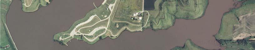
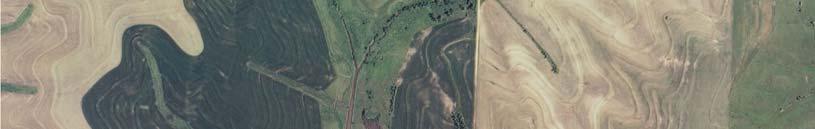
7 LAKE HISTORY AND PERTINENT INFORMATION Figure 1. Centralia City Lake, Nemaha County, Kansas.
8 Nemaha County, Kansas Bern Sabetha Oneida Seneca Centralia Centralia Lake Corning Goff Wetmore Ü Miles Figure 2. Location of Centralia Lake in Nemaha County, Kansas.
9 Reservoir Bathymetric (Depth) Surveying Procedures Pre-survey preparation: Geospatial reference data: Survey procedures: Calibration (Temperature and ball check): On-lake survey procedures:
10 Establishment Of Lake Level On Survey Dates: Centralia City Lake:

11 Location of Lake Elevation Benchmark:
12 USGS Home Contact USGS Search USGS National Water Information System: Web Interface USGS Water Resources Data Category: Geographic Area: News - updated November 2010 USGS CENTRALIA LK NR CENTRALIA, KS Available data for this site Lake Site DESCRIPTION: Latitude 39 41'46", Longitude 96 08'55" NAD83 Nemaha County, Kansas, Hydrologic Unit Drainage area: square miles Datum of gage: 1, feet above sea level NAVD88. AVAILABLE DATA: Data Type Begin Date End Date Count Real-time -- Previous 120 days -- OPERATION: Record for this site is maintained by the USGS Kansas Water Science Center questions about this site to Kansas Water Science Center Water-Data Inquiries Questions about sites/data? Feedback on this web site Automated retrievals Help Data Tips Explanation of terms Subscribe for system changes News Accessibility FOIA Privacy Policies and Notices U.S. Department of the Interior U.S. Geological Survey Title: ** USGS CENTRALIA LK NR CENTRALIA, KS URL: Page Contact Information: Kansas Water Data Support Team Page Last Modified: :07:38 EST vaww01


13 Ü Miles Figure 4. Bathymetric survey lines for Centralia City Lake
14 Post-processing (Visual Bottom Typer) The BioSonics, Inc. bottom tracker is an end_up" algorithm, in that it begins searching for the bottom echo portion of a ping from the last sample toward the first sample. The bottom tracker tracks the bottom echo by isolating the region(s) where the data exceeds a peak threshold for N consecutive samples, then drops below a surface threshold for M samples. Once a bottom echo has been identified, a bottom sampling window is used to find the next echo. The bottom echo is first isolated by user_defined threshold values that indicate (1) the lowest energy to include in the bottom echo (bottom detection threshold) and (2) the lowest energy to start looking for a bottom peak (peak threshold). The bottom detection threshold allows the user to filter out noise caused by a low data acquisition threshold. The peak threshold prevents the algorithm from identifying the small energy echoes (due to fish, sediment or plant life) as a bottom echo. Post-processing (Excel)
15 NOT Post-processing (ArcGIS):


16 Ü Depth in Feet ft Contours Miles Figure 5. Water depth based on December 14, 2009 bathymetric surveys for Centralia City Lake. Depths are based on a pool elevation of ft.
17 Table 1 Cumulative area in acres by tenth foot elevation increments Elevation (ft NGVD)
18 Table 2 Cumulative volume in acre-feet by tenth foot elevation increments Elevation (ft NGVD)
19 Cumulative Area (acres) Elevation (feet) Cumulative Volume (acre-feet) Elevation (feet)
20 SEDIMENT SAMPLING PROCEDURES Sediment samples were collected from three sites within the reservoir using a Wildco drop-corer (Wildlife Supply Company, Buffalo, NY). One sample is taken near the dam; a second at mid-lake; and a third in the upper end/transitional area. Sampling was performed on the same day as the bathymetric survey, following completion of the survey. As the drop-corer samples only the upper sediment, the entire sample in each case was collected and sealed in a sampling container. The samples were then shipped to the Kansas State University Soil Testing Laboratory (Manhattan, KS), for texture analysis. SEDIMENT SAMPLING RESULTS: Sampling sites were distributed across the length of the reservoir (Figure 8). Silt percentages were highest at the two inflow ends (CE-3, 66% and CE-7, 56%), decreasing to 3% at the dam end (CE-1) (Table 3; Figure 9; Figure 10). Table 3 Centralia City Lake Sediment Sampling Site Data CODE UTMX UTMY %Sand % Silt % Clay CE CE CE CE CE CE CE Coordinates are Universal Transverse Mercator (UTM), NAD83, Zone 14 North 14


21 Ü!. CE-5!. CE-1!. CE-8!. CE-2!. CE-3!. CE-4!. CE-6!. CE-7 Miles Figure 8. Location of sediment samples in Centralia City Lake
22 Centralia Reservoir 2010 Sediment Particle Size Analysis Sample Site


23 Ü CE-1! CE-5! CE-8! CE-2! CE-3 CE-4!! CE-6! CE-7! Particle Size Distribution Miles Sand Silt Clay Figure 10. Particle size distribution of sediment samples in Centralia City Lake Note: No particle size analysis was conducted for CE-8
Bathymetric and Sediment Survey of Atchison County Lake, Atchison County, Kansas
 Bathymetric and Sediment Survey of Atchison County Lake, Atchison County, Kansas Kansas Biological Survey Applied Science and Technology for Reservoir Assessment (ASTRA) Program Report 2010-04 (November
Bathymetric and Sediment Survey of Banner Creek Reservoir, Jackson County, Kansas
 Bathymetric and Sediment Survey of Banner Creek Reservoir, Jackson County, Kansas Kansas Biological Survey Applied Science and Technology for Reservoir Assessment (ASTRA) Program Report 2010-05 (December
Bathymetric and Sediment Survey of Pottawatomie Lake #1, Pottawatomie County, Kansas
 Bathymetric and Sediment Survey of Pottawatomie Lake #1, Pottawatomie County, Kansas Kansas Biological Survey Applied Science and Technology for Reservoir Assessment (ASTRA) Program Report 2010-10 (October
Bathymetric and Sediment Survey of Alma City Lake, Wabaunsee County, Kansas
 Bathymetric and Sediment Survey of Alma City Lake, Wabaunsee County, Kansas Kansas Biological Survey Applied Science and Technology for Reservoir Assessment (ASTRA) Program Report 2011-13 (March 2011)
Bathymetric and Sediment Survey of Elk City Reservoir, Montgomery County, Kansas
 Bathymetric and Sediment Survey of Elk City Reservoir, Montgomery County, Kansas Kansas Biological Survey Applied Science and Technology for Reservoir Assessment (ASTRA) Program Report 2010-01 (December
Bathymetric and Sediment Survey of Fall River Reservoir, Greenwood County, Kansas
 Bathymetric and Sediment Survey of Fall River Reservoir, Greenwood County, Kansas Kansas Biological Survey Applied Science and Technology for Reservoir Assessment (ASTRA) Program Report 2010-02 (May 2011)
Bathymetric and Sediment Survey of Kanopolis Reservoir, Ellsworth County, Kansas
 Bathymetric and Sediment Survey of Kanopolis Reservoir, Ellsworth County, Kansas Kansas Biological Survey Applied Science and Technology for Reservoir Assessment (ASTRA) Program Report 2008-09 (April 2009)
Bathymetric Survey of John Redmond Reservoir, Coffey County, Kansas
 Bathymetric Survey of John Redmond Reservoir, Coffey County, Kansas Kansas Biological Survey Applied Science and Technology for Reservoir Assessment (ASTRA) December 2007 SUMMARY During March and April
Stream Discharge and the Water Budget
 Regents Earth Science Unit 6: Water Cycle & Climate Name: Lab # Stream Discharge and the Water Budget Introduction: The United States Geological Survey (USGS) measures and publishes values for the daily
Hydrology and Floodplain Analysis, Chapter 10
 Hydrology and Floodplain Analysis, Chapter 10 Hydrology and Floodplain Analysis, Chapter 10.1 Introduction to GIS GIS Geographical Information System Spatial Data Data linked with geographical location
StreamStats: Delivering Streamflow Information to the Public. By Kernell Ries
 StreamStats: Delivering Streamflow Information to the Public By Kernell Ries U.S. Department of the Interior U.S. Geological Survey MD-DE-DC District 410-238-4317 kries@usgs.gov StreamStats Web Application
PRELIMINARY DRAFT FOR DISCUSSION PURPOSES
 Memorandum To: David Thompson From: John Haapala CC: Dan McDonald Bob Montgomery Date: February 24, 2003 File #: 1003551 Re: Lake Wenatchee Historic Water Levels, Operation Model, and Flood Operation This
3.0 TECHNICAL FEASIBILITY
 3.0 TECHNICAL FEASIBILITY 3.1 INTRODUCTION To enable seasonal storage and release of water from Lake Wenatchee, an impoundment structure would need to be constructed on the lake outlet channel. The structure
Butte County Fire Department
 Butte County Fire Department Basic Land Navigation Verification Sheet I verify that Print Supervisor's name Print Employee's name has completed the Basic Land Navigation self study guide on Date Attached
UPPER COSUMNES RIVER FLOOD MAPPING
 UPPER COSUMNES RIVER FLOOD MAPPING DRAFT BASIC DATA NARRATIVE FLOOD INSURANCE STUDY SACRAMENTO COUTY, CALIFORNIA Community No. 060262 November 2008 Prepared By: CIVIL ENGINEERING SOLUTIONS, INC. 1325 Howe
Butte County Fire Department
 Butte County Fire Department Basic Land Navigation Verification Sheet I verify that Print Supervisor s name has completed the Print Employee s name Basic Land Navigation self study guide on. Date Attached
LOCATED IN INDIAN RIVER COUNTY PREPARED FOR S.J.R.W.M.D. AND F.W.C.D. DECEMBER, 2003 Updated 2007 Updated May 2014 PREPARED BY
 FELLSMERE WATER CONTROL DISTRICT EAST MASTER DRAINAGE PLAN AND STORMWATER HYDROLOGIC ANALYSIS OF THE GRAVITY DRAINAGE SYSTEM LOCATED BETWEEN THE EAST BOUNDARY, LATERAL U, THE MAIN CANAL, AND DITCH 24 LOCATED
MaxDepth Aquatics, Inc.
 MaxDepth Aquatics, Inc. Bathymetry of Mirror Pond From Newport Bridge to Galveston Bridge Prepared for the City of Bend By Joseph Eilers & Benn Eilers MaxDepth Aquatics, Inc. Bend, OR June 2005 INTRODUCTION
4 Survey Datums. 4.1 Horizontal Datum Policy SURVEY DATUMS SEPTEMBER 2006
 4 Survey Datums Today s multi-organizational Project Development efforts require the use of common, accurate horizontal and vertical survey datums and consistent, precise control-survey procedures to ensure
LOMR SUBMITTAL LOWER NESTUCCA RIVER TILLAMOOK COUNTY, OREGON
 LOMR SUBMITTAL LOWER NESTUCCA RIVER TILLAMOOK COUNTY, OREGON Prepared for: TILLAMOOK COUNTY DEPARTMENT OF COMMUNITY DEVELOPMENT 1510-B THIRD STREET TILLAMOOK, OR 97141 Prepared by: 10300 SW GREENBURG ROAD,
STRUCTURAL STABILITY ASSESSMENT
 STRUCTURAL STABILITY ASSESSMENT CFR 257.73(d) Bottom Ash Pond Complex Cardinal Plant Brilliant, Ohio October, 2016 Prepared for: Cardinal Operating Company Cardinal Plant Brilliant, Ohio Prepared by: Geotechnical
Lake Sedimentation Survey of Siloam Springs State Park Lake, Adams County, Illinois
 Contract Report 567 Lake Sedimentation Survey of Siloam Springs State Park Lake, Adams County, Illinois by Richard L. Allgire Office of Sediment & Wetland Studies Prepared for the Illinois Department of
Bathymetric Survey of Select Dissolved Oxygen Impaired Reservoirs
 Bathymetric Survey of Select Dissolved Oxygen Impaired Reservoirs FY 2018 PROJECT #3 FY18/19 106 I-006400-17 TABLE A-1 LAKES Q-TRAK #18-205 PREPARED BY: OKLAHOMA WATER RESOURCES BOARD PREPARED FOR: OKLAHOMA
Evaluating Physical, Chemical, and Biological Impacts from the Savannah Harbor Expansion Project Cooperative Agreement Number W912HZ
 Evaluating Physical, Chemical, and Biological Impacts from the Savannah Harbor Expansion Project Cooperative Agreement Number W912HZ-13-2-0013 First Quarterly Report January 14, 2014 Submitted by Thomas
Evaluating Physical, Chemical, and Biological Impacts from the Savannah Harbor Expansion Project Cooperative Agreement Number W912HZ
 Evaluating Physical, Chemical, and Biological Impacts from the Savannah Harbor Expansion Project Cooperative Agreement Number W912HZ-13-2-0013 FY 2016 - First Quarterly Report January 1, 2016 Submitted
Sedimentation Survey of Lake Decatur s Basin 6, Macon County, Illinois
 Contract Report 2001-07 Sedimentation Survey of Lake Decatur s Basin 6, Macon County, Illinois by William C. Bogner Prepared for the City of Decatur May 2001 Illinois State Water Survey Watershed Science
This week s topics. Week 6. FE 257. GIS and Forest Engineering Applications. Week 6
 FE 257. GIS and Forest Engineering Applications Week 6 Week 6 Last week Chapter 8 Combining and splitting landscape features and merging GIS databases Chapter 11 Overlay processes Questions? Next week
Evaluating Physical, Chemical, and Biological Impacts from the Savannah Harbor Expansion Project Cooperative Agreement Number W912HZ
 Evaluating Physical, Chemical, and Biological Impacts from the Savannah Harbor Expansion Project Cooperative Agreement Number W912HZ-13-2-0013 Second Quarterly Report - 2017 Submitted by Sergio Bernardes
Hydrographic Surveys for Six Water Bodies in Eastern Nebraska,
 University of Nebraska - Lincoln DigitalCommons@University of Nebraska - Lincoln Publications of the US Geological Survey US Geological Survey 2008 Hydrographic Surveys for Six Water Bodies in Eastern
Illinois State Water Survey Division
 Illinois State Water Survey Division SURFACE WATER SECTION SWS Contract Report 413 AT THE UNIVERSITY OF ILLINOIS SEDIMENTATION SURVEY OF DAWSON LAKE, MORAINE VIEW STATE PARK, MC LEAN COUNTY, ILLINOIS by
Pierce Cedar Creek Institute GIS Development Final Report. Grand Valley State University
 Pierce Cedar Creek Institute GIS Development Final Report Grand Valley State University Major Goals of Project The two primary goals of the project were to provide Matt VanPortfliet, GVSU student, the
Sedimentation Survey of Lake Paradise and Lake Mattoon, Mattoon, Illinois
 Contract Report 2003-04 Sedimentation Survey of Lake Paradise and Lake Mattoon, Mattoon, Illinois by William C. Bogner Prepared for the CMT Engineering Company City of Mattoon and Illinois Environmental
Mobile District River System Status for November 17, 2017
 Mobile District River System Status for November 17, 2017 Weather Update The Quantitative Precipitation Forecast (QPF) in Figure 1 shows forecasted precipitation for the next 7 days. Figure 2 shows the
GIS in Water Resources Fall 2018 Homework #1
 GIS in Water Resources Fall 2018 Homework #1 Goal The goal of this homework is to reinforce the lecture material on Geodesy, Map Projections and Coordinate Systems by having you identify attributes and
Natural Variability in Annual Maximum Water Level and Outflow of Yellowstone Lake
 Natural Variability in Annual Maximum Water Level and Outflow of Yellowstone Lake Phillip E. Farnes Abstract The water level in Yellowstone Lake varies each year in response to differences in the winter
Evaluating Physical, Chemical, and Biological Impacts from the Savannah Harbor Expansion Project Cooperative Agreement Number W912HZ
 Evaluating Physical, Chemical, and Biological Impacts from the Savannah Harbor Expansion Project Cooperative Agreement Number W912HZ-13-2-0013 Annual Report FY 2018 Submitted by Sergio Bernardes and Marguerite
History of Cartography,
 Maps History of Cartography, the art and science of making maps ~2300 BC ~600 BC Early oldest known maps: Babylonian clay tablets. Greek and Roman Ptolemy s (about AD 85-165) "world map" depicted the Old
Highland Lake Bathymetric Survey
 Highland Lake Bathymetric Survey Final Report, Prepared For: The Town of Highland Lake 612 Lakeshore Drive Oneonta, AL 35121 Prepared By: Tetra Tech 2110 Powers Ferry Road SE Suite 202 Atlanta, GA 30339
Methods for Assessing Sedimentation in Reservoirs
 Methods for Assessing Sedimentation in Reservoirs Mark Jakubauskas, Research Associate Professor Frank denoyelles, Deputy Director and Professor Applied Science and Technology for Reservoir Assessment
LOMR SUBMITTAL LOWER NEHALEM RIVER TILLAMOOK COUNTY, OREGON
 LOMR SUBMITTAL LOWER NEHALEM RIVER TILLAMOOK COUNTY, OREGON Prepared for: TILLAMOOK COUNTY DEPARTMENT OF COMMUNITY DEVELOPMENT 1510-B THIRD STREET TILLAMOOK, OR 97141 Prepared by: 10300 SW GREENBURG ROAD,
Laboratory Exercise #3 The Hydrologic Cycle and Running Water Processes
 Laboratory Exercise #3 The Hydrologic Cycle and Running Water Processes page - 1 Section A - The Hydrologic Cycle Figure 1 illustrates the hydrologic cycle which quantifies how water is cycled throughout
Control Surveys and Coordinate Systems
 Control Surveys and Coordinate Systems The Earth is Round Basic Shape of the Earth: Oblate Spheroid of Revolution The length of the equatorial axis is approximately 27 miles greater than the polar axis.
Implementing a Project with 319 Funds: The Spring Brook Meander Project. Leslie A. Berns
 Implementing a Project with 319 Funds: The Spring Brook Meander Project Leslie A. Berns "...to acquire... and hold lands... for the purpose of protecting and preserving the flora, fauna and scenic beauties...
Designing a Dam for Blockhouse Ranch. Haley Born
 Designing a Dam for Blockhouse Ranch Haley Born CE 394K GIS in Water Resources Term Paper Fall 2011 Table of Contents Introduction... 1 Data Sources... 2 Precipitation Data... 2 Elevation Data... 3 Geographic
Bathymetric Survey of Select Dissolved Oxygen Impaired Reservoirs
 Bathymetric Survey of Select Dissolved Oxygen Impaired Reservoirs FY 2017 PROJECT #3 FY16/17 106 I-006400-15 TABLE A-1 LAKES Q-TRAK #17-085 PREPARED BY: OKLAHOMA WATER RESOURCES BOARD PREPARED FOR: OKLAHOMA
Version TNW Only 1 of 3
 APPROVED JURISDICTIONAL DETERMINATION FORM U.S. Army Corps of Engineers SECTION I: BACKGROUND INFORMATION A. REPORT COMPLETION DATE FOR APPROVED JURISDICTIONAL DETERMINATION (JD): 3 Mar 2009. B. DISTRICT
Hydrographic Survey Program Texas Water Development Board. Nathan Leber Holly Holmquist Khan Iqbal Josh Duty Eli Pruitt
 Hydrographic Survey Program Texas Water Development Board Nathan Leber Holly Holmquist Khan Iqbal Josh Duty Eli Pruitt The following presentation is based upon professional research and analysis within
B-1. Attachment B-1. Evaluation of AdH Model Simplifications in Conowingo Reservoir Sediment Transport Modeling
 Attachment B-1 Evaluation of AdH Model Simplifications in Conowingo Reservoir Sediment Transport Modeling 1 October 2012 Lower Susquehanna River Watershed Assessment Evaluation of AdH Model Simplifications
B. Topographic maps are also called. contour maps
 Topographic Maps Introduction A. Topographic maps are essential tools in geologic and engineering studies because they show the configuration of Earth's surface in remarkable detail and permit one to measure
Delineation of Watersheds
 Delineation of Watersheds Adirondack Park, New York by Introduction Problem Watershed boundaries are increasingly being used in land and water management, separating the direction of water flow such that
GeoWEPP Tutorial Appendix
 GeoWEPP Tutorial Appendix Chris S. Renschler University at Buffalo - The State University of New York Department of Geography, 116 Wilkeson Quad Buffalo, New York 14261, USA Prepared for use at the WEPP/GeoWEPP
Name NRS 409 Exam I. 1. (24 Points) Consider the following questions concerning standard data for GIS systems.
 Consider the following questions concerning standard data for GIS systems.") Read every question carefully. You may use a calculator if you wish. Conversion tables are provided at the end of the exam. If you have any questions, raise your hand. Be sure to show your work on computational
Read every question carefully. You may use a calculator if you wish. Conversion tables are provided at the end of the exam. If you have any questions, raise your hand. Be sure to show your work on computational
What is a Map Projection?
 What is a Map Projection? It is how we represent a three dimensional Earth on a flat piece of paper However The process of transferring information from the Earth to a map causes every projection to distort
How Do Geology and Physical Streambed Characteristics Affect Water Quality?
 Teacher s Guide How Do Geology and Physical Streambed Characteristics Affect Water Quality? Lesson Description In this lesson, the students research a dynamic, vertical dimension of a watershed - the geological
GIS in Water Resources Midterm Exam Fall 2008 There are 4 questions on this exam. Please do all 4.
 Page 1 of 8 Name: GIS in Water Resources Midterm Exam Fall 2008 There are 4 questions on this exam. Please do all 4. 1. Basic Concepts [20 points] Find the letter with the best answer for each term: 1.
KANSAS GEOLOGICAL SURVEY Open File Report LAND SUBSIDENCE KIOWA COUNTY, KANSAS. May 2, 2007
 KANSAS GEOLOGICAL SURVEY Open File Report 2007-22 LAND SUBSIDENCE KIOWA COUNTY, KANSAS Prepared by Michael T. Dealy L.G., Manager, Wichita Operations SITE LOCATION The site was approximately four miles
ARMSTRONG COUNTY, PA
 ARMSTRONG COUNTY, PA Revised Preliminary DFIRM Mapping March 31, 2013 Kevin Donnelly, P.E., CFM GG3, Greenhorne & O Mara, Inc. Presentation Agenda Armstrong County DFIRM Overview - June 25, 2010 DFIRM
ENTERGY WHITE BLUFF PLANT RECYCLE POND A AND RECYCLE POND B DEMONSTRATION OF COMPLIANCE WITH EPA CCR RULE SITING CRITERIA 257.
 ENTERGY WHITE BLUFF PLANT RECYCLE POND A AND RECYCLE POND B DEMONSTRATION OF COMPLIANCE WITH EPA CCR RULE SITING CRITERIA 257.62, FAULT AREAS Prepared for Entergy Arkansas, Inc. PO Box 551 Little Rock,
2012 Rainfall, Runoff, Water Level & Temperature Beebe Lake Wright County, MN (# )
") www.fixmylake.com 18029 83 rd Avenue North Maple Grove, MN 55311 mail@freshwatersci.com (651) 336-8696 2012 Rainfall, Runoff, Water Level & Temperature Beebe Lake Wright County, MN (#86-0023) Prepared
www.fixmylake.com 18029 83 rd Avenue North Maple Grove, MN 55311 mail@freshwatersci.com (651) 336-8696 2012 Rainfall, Runoff, Water Level & Temperature Beebe Lake Wright County, MN (#86-0023) Prepared
Internet GIS Sites. 2 OakMapper webgis Application
 Internet GIS Sites # Name URL Description 1 City of Sugar Land http://www.sugarlandtx.gov/index.htm It is a city in Texas with 65,000 Residents. The City of Sugar Land, Texas, provides ArcIMS-based maps
BUILDING AN ACCURATE GIS
 BUILDING AN ACCURATE GIS 2006 GIS in the Rockies Denver, Colorado September 13, 2006 William E. Linzey United States Department of Commerce National Oceanic and Atmospheric Administration National Geodetic
LiDAR User Data Needs Survey Results
 LiDAR User Data Needs Survey Results June 2012 Introduction The Minnesota Geospatial Information Office (MnGeo) is working with the Minnesota Department of Natural Resources (DNR) to develop a data distribution
SHAWN NAYLOR. Research Hydrogeologist Center for Geospatial Data Analysis, Indiana Geological Survey
 SHAWN NAYLOR Research Hydrogeologist Center for Geospatial Data Analysis, Indiana Geological Survey Project overview Funded by American Recovery and Reinvestment Act Develop distributed network of databases
APPENDIX A GLOSSARY. Appendix A.1
 APPENDIX A GLOSSARY Appendix A.1 Appendix A.2 Back Bearing A back bearing is measured from the object to your position. It is the exact opposite of a direct bearing. Base Line An imaginary line on the
CR AAO Bridge. Dead River Flood & Natural Channel Design. Mitch Koetje Water Resources Division UP District
 CR AAO Bridge Dead River Flood & Natural Channel Design Mitch Koetje Water Resources Division UP District Old County Road AAO Bridge Map courtesy of Marquette County Silver Lake Basin McClure Basin
Glossary. ARC: American Red Cross. ASOS: Automated Surface Observing System (NWS & FAA) ATM: Abbreviated Transportation Model
 ATM: Abbreviated Transportation Model") A AFN Access and Functional Needs. People who may have additional needs before, during, and after an incident in functional areas, including but not limited to: maintaining independence, communication,
A AFN Access and Functional Needs. People who may have additional needs before, during, and after an incident in functional areas, including but not limited to: maintaining independence, communication,
Understanding China Census Data with GIS By Shuming Bao and Susan Haynie China Data Center, University of Michigan
 Understanding China Census Data with GIS By Shuming Bao and Susan Haynie China Data Center, University of Michigan The Census data for China provides comprehensive demographic and business information
Merced Irrigation District Hydrologic and Hydraulic Operations (MIDH2O) Model
 Model") Merced Irrigation District Hydrologic and Hydraulic Operations (MIDH2O) Model September 05, 2018 Marco Bell, Merced Irrigation District Bibek Joshi, Dewberry Objective Introduce HEC-RTS Benefits of MIDH2O
Merced Irrigation District Hydrologic and Hydraulic Operations (MIDH2O) Model September 05, 2018 Marco Bell, Merced Irrigation District Bibek Joshi, Dewberry Objective Introduce HEC-RTS Benefits of MIDH2O
Alluvial Soils: Fine grained sediment, especially of mud or clay particles at the bottom of a river or lake.
 A Alluvial Soils: Fine grained sediment, especially of mud or clay particles at the bottom of a river or lake. Average Error Affected List: Average Error Swath: ARC: American Red Cross ASOS: Automated
MEMORANDUM. Jerry Conrow, Ojai Basin Groundwater Management Agency
 MEMORANDUM TO: FROM: Jerry Conrow, Ojai Basin Groundwater Management Agency Gregory Schnaar, PhD, Stephen J. Cullen, PhD, PG, DATE: August 6, 2014, 2014 SUBJECT: Ojai Basin Groundwater Model - Extended
Limitation to qualitative stability indicators. the real world is a continuum, not a dichotomy ~ 100 % 30 % ~ 100 % ~ 40 %
 Stream Stability Assessment & BEHI Surveys Joe Rathbun MDEQ Water Resources Division rathbunj@michigan.gov 517--373 517 373--8868 Stability Stream can transport its water and sediment inputs without changing
Section 4: Model Development and Application
 Section 4: Model Development and Application The hydrologic model for the Wissahickon Act 167 study was built using GIS layers of land use, hydrologic soil groups, terrain and orthophotography. Within
Landslide Computer Modeling Potential
 Landslide Computer Modeling Potential Michael D. Dixon, P.E. Civil Engineer Payette National Forest The Payette National Forest selected the Stability Index Mapping (SINMAP) model for use in identifying
Climate. Annual Temperature (Last 30 Years) January Temperature. July Temperature. Average Precipitation (Last 30 Years)
 January Temperature. July Temperature. Average Precipitation (Last 30 Years)") Climate Annual Temperature (Last 30 Years) Average Annual High Temp. (F)70, (C)21 Average Annual Low Temp. (F)43, (C)6 January Temperature Average January High Temp. (F)48, (C)9 Average January Low Temp.
Climate Annual Temperature (Last 30 Years) Average Annual High Temp. (F)70, (C)21 Average Annual Low Temp. (F)43, (C)6 January Temperature Average January High Temp. (F)48, (C)9 Average January Low Temp.
9. PROBABLE MAXIMUM PRECIPITATION AND PROBABLE MAXIMUM FLOOD
 9. PROBABLE MAXIMUM PRECIPITATION AND PROBABLE MAXIMUM FLOOD 9.1. Introduction Due to the size of Watana Dam and the economic importance of the Project to the Railbelt, the Probable Maximum Flood (PMF)
Tri-County Regional Planning Commission Regional Zoning GIS Project Documentation
 Tri-County Regional Planning Commission Regional Zoning GIS Project Documentation 12/13/00 Revised 11/07/2007 Projection Michigan GeoRef: From PDF file on Center for Geographic Information s web site:
Guide to Hydrologic Information on the Web
 NOAA s National Weather Service Guide to Hydrologic Information on the Web Colorado River at Lees Ferry Photo: courtesy Tim Helble Your gateway to web resources provided through NOAA s Advanced Hydrologic
Topographic Maps and Landforms Geology Lab
 Topographic Maps and Landforms Geology Lab Ray Rector: Instructor Today s Lab Activities 1) Discussion of Last Week s Lab 2) Lecture on Topo Maps and Elevation Contours 3) Construct Topographic Maps and
APPROVED JURISDICTIONAL DETERMINATION FORM U.S. Army Corps of Engineers
 APPROVED JURISDICTIONAL DETERMINATION FORM U.S. Army Corps of Engineers This form should be completed by following the instructions provided in Section IV of the JD Form Instructional Guidebook. SECTION
Evaluating Physical, Chemical, and Biological Impacts from the Savannah Harbor Expansion Project Cooperative Agreement Number W912HZ
 Evaluating Physical, Chemical, and Biological Impacts from the Savannah Harbor Expansion Project Cooperative Agreement Number W912HZ-13-2-0013 Annual Report FY 2017 Submitted by Sergio Bernardes and Marguerite
Giant Kangaroo Rat Dispersion Analysis
 Giant Kangaroo Rat Dispersion Analysis ABBY RUTROUGH, Department of Wildlife, Humboldt State University, 1 Harpst St, Arcata, CA 95521. DYLAN SCHERTZ, Department of Wildlife, Humboldt State University,
Local Flood Hazards. Click here for Real-time River Information
 Local Flood Hazards Floods of the White River and Killbuck Creek are caused by runoff from general, and/or intense rainfall. Other areas of flooding concern are from the Boland Ditch and Pittsford Ditch.
Lake Champlain Richelieu River Flood Inundation Mapping and Forecasting Tool
 Lake Champlain Richelieu River Flood Inundation Mapping and Forecasting Tool Rob Flynn USGS New England Water Science Center, NH/VT Office U.S. Department of the Interior U.S. Geological Survey Lake Champlain
Assessment of Lake Forest Lake Sediment Trapping Efficiency and Capacity. Marlon R. Cook Groundwater Assessment Program Geological Survey of Alabama
 Assessment of Lake Forest Lake Sediment Trapping Efficiency and Capacity Marlon R. Cook Groundwater Assessment Program Geological Survey of Alabama Impacts of the Lake at Lake Forest on the connectivity
APPROVED JURISDICTIONAL DETERMINATION FORM U.S. Army Corps of Engineers
 APPROVED JURISDICTIONAL DETERMINATION FORM U.S. Army Corps of Engineers This form should be completed by following the instructions provided in Section IV of the JD Form Instructional Guidebook. SECTION
APPROVED JURISDICTIONAL DETERMINATION FORM U.S. Army Corps of Engineers
 APPROVED JURISDICTIONAL DETERMINATION FORM U.S. Army Corps of Engineers This form should be completed by following the instructions provided in Section IV of the JD Form Instructional Guidebook. SECTION
M E M O R A N D U M. Mr. Jonathan K. Thrasher, P.E., Mr. Ian Kinnear, P.E. (FL) PSI
 PSI") M E M O R A N D U M TO: FROM: Mr. Mark Schilling Gulf Interstate Engineering Mr. Jonathan K. Thrasher, P.E., Mr. Ian Kinnear, P.E. (FL) PSI DATE: November 11, 2014 RE: Summary of Findings Geotechnical
M E M O R A N D U M TO: FROM: Mr. Mark Schilling Gulf Interstate Engineering Mr. Jonathan K. Thrasher, P.E., Mr. Ian Kinnear, P.E. (FL) PSI DATE: November 11, 2014 RE: Summary of Findings Geotechnical
Adam Munson, Environmental Scientist III Resource Conservation and Development Department Southwest Florida Water Management District
 April 27, 2004 MEMORANDUM TO: FROM: File Adam Munson, Environmental Scientist III Resource Conservation and Development Department Southwest Florida Water Management District SUBJECT: Proposed minimum
Modeling Hydrodynamic Effects and Salinity Intrusion. Presented by Dr. Eric Swain, USGS Water Science Center, Fort Lauderdale Florida
 Modeling Hydrodynamic Effects and Salinity Intrusion Presented by Dr. Eric Swain, USGS Water Science Center, Fort Lauderdale Florida Requirements Because coastal South Florida has unique features such
Laboratory Exercise #4 Geologic Surface Processes in Dry Lands
 Page - 1 Laboratory Exercise #4 Geologic Surface Processes in Dry Lands Section A Overview of Lands with Dry Climates The definition of a dry climate is tied to an understanding of the hydrologic cycle
APPLICATION FOR CONDITIONAL ABSOLUTE WATER STORAGE RIGHT
 District Court, Water Division, Colorado Court Address: CONCERNING THE APPLICATION FOR WATER RIGHTS OF Applicant: In the River or its Tributaries In COUNTY Attorney or Party Without Attorney (Name and
MASON COUNTY, MICHIGAN
 MASON COUNTY, MICHIGAN (ALL JURISDICTIONS) MASON COUNTY Community Community Community Community Name Number Name Number AMBER, TOWNSHIP OF 261271 LOGAN, TOWNSHIP OF 260811 BRANCH, TOWNSHIP OF 261272 LUDINGTON,
Detroit 516 Activities
 Detroit 516 Activities Dam Capacity Study Sediment Workshop in Traverse City START 2.0 Saginaw River Study Dam Capacity Study A progress report Outline Study Objective (Why are we doing this?) Reservoir
HORIZONTAL PROJECTION PARAMETERS: DANE COUNTY COORDINATES
 Recommended RTK GPS Configuration Parameters for the City of Madison, WI Base Station Compiled by: Dan Rodman RLS, City of Madison (608)266-6674 drodman@cityofmadison.com For base station information see
Georeferencing, Map Projections, Cartographic Concepts. -Coordinate Systems -Datum
 Georeferencing, Map Projections, Cartographic Concepts -Map Projections -Coordinate Systems -Datum Map projection is "the process of systematically transforming positions on the Earth's spherical surface
AN ASSESSMENT OF THE IMPACT OF RETENTION PONDS
 AN ASSESSMENT OF THE IMPACT OF RETENTION PONDS FOR SEDIMENT TRAPPING IN THE ADA CREEK AND LONGWOOD COVE USING REMOTELY SENSED DATA AND GIS ANALYSIS Sudhanshu Sekhar Panda Associate Professor, GIS/Env.
GPS- vs. DEM-Derived Elevation Estimates from a Hardwood Dominated Forest Watershed
 Journal of Geographic Information System, 2010, 2, 147-151 doi:10.4236/jgis.2010.23021 Published Online July 2010 (http://www.scirp.org/journal/jgis) GPS- vs. DEM-Derived Elevation Estimates from a Hardwood
Mobile District River System Status for October 25, 2018
 Mobile District River System Status for October 25, 2018 Weather Update The Quantitative Precipitation Forecast (QPF) in Figure 1 shows 0.4 to 2.5 inches of precipitation forecasted for the next 7 days.
Native species (Forbes and Graminoids) Less than 5% woody plant species. Inclusions of vernal pools. High plant diversity
 Less than 5% woody plant species. Inclusions of vernal pools. High plant diversity") WILLAMETTE VALLEY WET-PRAIRIE RESTORATION MODEL WHAT IS A WILLAMETTE VALLEY WET-PRAIRIE Hot Spot s Native species (Forbes and Graminoids) Rare plant species Less than 5% woody plant species Often dominated
WILLAMETTE VALLEY WET-PRAIRIE RESTORATION MODEL WHAT IS A WILLAMETTE VALLEY WET-PRAIRIE Hot Spot s Native species (Forbes and Graminoids) Rare plant species Less than 5% woody plant species Often dominated
Canadian Digital Elevation Data
 Natural Resources Canada Geomatics Canada Ressources naturelles Canada Géomatique Canada Canadian Digital Elevation Data Standards and Specifications Centre for Topographic Information Customer Support