State GIS Update. Master Address Repository (MAR) IMAGIN 2016 Everett Root May 16, 2016
|
|
|
- Pamela Harris
- 6 years ago
- Views:
Transcription
1 State GIS Update Master Address Repository (MAR) IMAGIN 2016 Everett Root May 16, 2016
2 Master Address Repository Mark Holmes GeoSpatial Services Manager (MAR) Josh Ross Framework Manager Tony Olkowski Open Data Portal Steve Cross Parcel Repository Nan Ewald GIS Analyst
3 Office of Technology Partnerships GIS Collaboration Communication / Outreach to Local GIS GIS Users Meeting 1st Thursday of even numbered months in Lansing Agenda: Informal Networking Update and short Special topic Afternoon Educational topic Call in capability Minutes & past presentations on web June 2 nd at Camp Grayling August 4 th at MSU Library

4 Office of Technology Partnerships GIS Collaboration GIS Listserv ~800 members Average ~10 s per month User group announcements/reminders/agenda RSS feed to view the last 100 s View via IE or subscribe to receive downloads

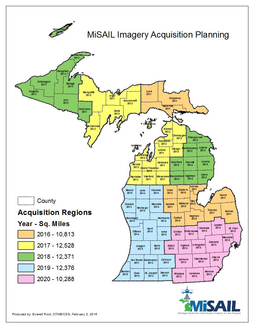
5 Michigan Statewide Authoritative Imagery & Lidar (MiSAIL) Annual acquisition of ~12K sq. miles / year Partnerships available Partner gets a copy and has complete distribution rights State gets a copy and defers distribution to partner 12, 4-band base product Statewide tiling scheme
6 Michigan Statewide Authoritative Imagery & Lidar (MiSAIL) Benefits to partnering Industry standard specifications (both imagery and LiDAR) RFP process complete Contract management Vendor management Acquisition Production Deliverables Quality Assurance
7 Michigan Statewide Authoritative Imagery & Lidar (MiSAIL) Benefits to partnering cont. Accountability in deliverables and deadlines Support team of State Attorney General and DTMB Procurement Additional products and technologies available from vendors Unmanned Aerial Systems (UAS) Change detection Image interpretation 3D buildings
8 Michigan Authoritative Imagery & LiDAR (MiSAIL) Axis GeoSpatial LLC - Easton MD for Imagery Sanborn Map Co. - Colorado Springs CO for LiDAR Imagery Partnership Similar deliverables to previous plan New Partnership price: $24 / sq. mile 12 Contiguity discounts applied where available as low as $21.75 / sq. mile Includes State of Michigan QA/QC New for 2016: Partners will have secure access to a hosted imagery service of their 2016 County imagery 6, 3 and True-Ortho buyups also available
9
10 Michigan Authoritative Imagery & LiDAR (MiSAIL) LiDAR Significant price reduction from previous contract Deliverables similar to previous program Raw point cloud - Calibrated unclassified Classified Point Cloud Bare-Earth Surface Hydro-flattened Bare-Earth Surface Hydro-enforced DEM Intensity images Meets current and future USGS specifications V1.2 for the fall 2015 and spring 2016 acquisitions
11 Michigan Statewide Authoritative Imagery & Lidar (MiSAIL) Federal relationship FEMA 2015 Lidar FEMA 2016 Lidar US Interagency Elevation Inventory USIEI coast.noaa.gov/inventory USGS TNM Download - viewer.nationalmap.gov/
12 Michigan Statewide Authoritative Imagery & Lidar (MiSAIL) Why isn t imagery available for free? 20% area acquisition goal: Cost ~ $350K - PLUS FTE (about $150K annually) Annual budget ~ $285K annually Funded by MDOT, MDNR, MDEQ GAP is filled by partnerships ($24/sq. mile) or less Suggestion: I ll trade GIS data for imagery
13 County GIS Parcel Repository CSS Parcel Repository Design and Architecture Framework for parcels to be shared with State Agencies CSS is collaborating with pilot counties, ESRI, Michigan Association of Equalization Directors, State Treasury Department, BS&A Repository uses ESRI Community Parcels model Pilot with volunteer counties Develop reporting map for Audit of Minimum Assessing Requirements (AMAR) Pilot data schema is finalized Data loaded from pilot counties
14 Parcel Repository State Agencies use parcel data for multiple crossjurisdictional purposes Emergency Management Boundary validation for voter file, school districts Environmental Land management Regional planning

15 County GIS Parcel Repository
16 County GIS Parcel Repository Next Steps Continue to load data as it becomes available Test access to data with SOM focus group Test AMAR map process Test data access by community partners Other ESRI map templates

17 Open Data Portal
18 Open Data Portal
19 Census Bureau Programs DTMB - Center for Shared Solutions will be liaison for Census Bureau data collection from local jurisdictions in 2016 Boundary and Annexation Survey (BAS) program Boundary Quality Assessment and Reconciliation Project (BQARP) School District Boundary Review Program Block Boundary Suggestion Program (BBSP)


20 Key Components of the GSS An integrated program that utilizes a partnership program for: Improved address coverage Periodic, transaction-based address and spatial feature updates Enhanced quality assessment and measurement Address Updates 123 Testdata Road Anytown, CA Street/Feature Updates Quality Measurement Lat 37 degrees, 9.6 minutes N Lon 119 degrees, 45.1 minutes W 20
21 The GSS Partnership Program Launched in October 2012 Opportunity for tribal, state, county, and local governments to continually exchange address & spatial data with the Census Bureau Recognizes partner governments as a definitive authority for quality address and street data within their communities Leverages the Census Bureau s broad partner network to encourage participation 21
22 Benefits of Participation 1. Expanded ROI encourages re-use of local government geospatial data investment 2. Reduces redundant federal data collection efforts and increases usage of high-quality local government data for multiple federal programs, including the 2020 Census and the USGS National Map 3. Provide maximum input into the American Community Survey and closes the gap between partner addresses and Census addresses for LUCA
23 What is the Basic Process? 1. Acquire partner data and perform Content Verification to determine general usability 2. Crosswalk, standardize, match, and geocode partner addresses and structure points using the Master Address File (MAF) 3. Match street centerline data to identify differences, calculate spatial accuracy (CE95 method) of partner data using GPS control points 4. Ideal Scenario: new addresses are added to the MAF, new streets are added to TIGER, address and spatial inconsistencies are submitted for resolution 23
24 Census Bureau Programs cont. Geographic Support System (GSS) Data sharing IGA Option to allow the State to use the data in-house as well Individual addresses and latitude and longitude coordinates submitted through the GSS are protected under Title 13 of the U. S. Code.
25 CSS Enterprise GIS ArcGIS Server Data storage Reference SDE Map Services MDOT MiDrive, TAMS Transportation Asset Management System MDNR Wildland Fire, Trails MDEQ Geowebface, Hazardous Sites, Coastal programs DHHS Desktop training and support MSP State Emergency Operations Center (SEOC)


26 Michigan Geographic Framework Data Elements of the MGF Cities Villages Townships Census Designated Places School Districts Legislative Boundaries Unincorporated Places Census Tracts and Block Groups Adjusted Census Urban Areas Public Road Centerlines Private Road Centerlines Rail Centerlines Bridge Structures Rail Crossings Federal Forest Roads Boating Access Sites Trails Hydrography Features


27 DTMB Strategic Plan Mobile First - MiPage Mobile friendly sites MiHUNT MiDrive MDE Summer Food Service MiSACWIS SOS Branch Office Locator MiPage will have more than 3 million downloads and feature more than 300 services by 2018
28 Thank you! Questions? Everett Root
Office of Technology Partnerships GIS Collaboration
 Office of Technology Partnerships GIS Collaboration State GIS Update April 21, 2017 Mark Holmes, GISP Outline MGF Upgrade Project Census Programs Imagery Update LiDAR Update Open Discussion 2 MGF Background
The 2020 Census Geographic Partnership Opportunities
 The 2020 Census Geographic Partnership Opportunities Web Adams Geographer, U.S. Census Bureau New York Regional Office 1 Geographic Partnership Opportunities The 2020 Census Local Update of Census Addresses
2010 Census Data Release and Current Geographic Programs. Michaellyn Garcia Geographer Seattle Regional Census Center
 2010 Census Data Release and Current Geographic Programs Michaellyn Garcia Geographer Seattle Regional Census Center 2010 Center of Population Located approximately 2.7 miles northeast of Plato, Missouri
Emergency Planning. for the. Democratic National. Convention. imaging notes // Spring 2009 //
 Emergency Planning for the Democratic National Convention The DRAPP Demonstrates Partnership among Local, Regional, State, Utility and Federal Governments 14 imaging notes // Spring 2009 // www.imagingnotes.com
Maryland State Geographic Information Committee
 MD IMAP 3.0 Next generation of MD imap platform running on Esri s ArcGIS Enterprise Promoting authoritative data sharing among State agencies via Portal for ArcGIS Centralization of GIS infrastructure
The 3D Elevation Program: Overview. Jason Stoker USGS National Geospatial Program ESRI 2015 UC
 + The 3D Elevation Program: Overview Jason Stoker USGS National Geospatial Program ESRI 2015 UC + 2 A little history USGS has a long, proud tradition of mapmaking (2009) + 3 The changing times Mapping
GIS Monroe Geographic Information System March 14, 2018
 GIS Monroe Geographic Information System March 14, 2018 Goals Maintain Enterprise/County-wide geo-database Increase spatial accuracy of data Build and acquire more data layers Increase use of GIS; as another
Continental Divide National Scenic Trail GIS Program
 CDNST Vision Statement: Provide the most accurate geospatial locational information of the Continental Divide Trail and nearby resources to the public as well as help provide internal management information
2013 NASCIO Award Submission Category: Cross-Boundary Collaboration and Partnerships. Project Title: Public Safety and Enterprise GIS in Tennessee
 2013 NASCIO Award Submission Category: Cross-Boundary Collaboration and Partnerships Project Title: Public Safety and Enterprise GIS in Tennessee State of Tennessee, Board of Parole State of Tennessee,
UTAH S STATEWIDE GEOGRAPHIC INFORMATION DATABASE
 UTAH S STATEWIDE GEOGRAPHIC INFORMATION DATABASE Data Information and Knowledge Management NASCIO Awards 2009 STATE GEOGRAPHIC INFORMATION DATABASE B. EXECUTIVE SUMMARY Utah has developed one of the most
USGS National Geospatial Program Understanding User Needs. Dick Vraga National Map Liaison for Federal Agencies July 2015
 + USGS National Geospatial Program Understanding User Needs Dick Vraga National Map Liaison for Federal Agencies July 2015 + Topics 2 Background Communities of Use User Surveys National Map Liaisons Partnerships
Exploring GIS Potential for Northwestern Ontario Land Information Ontario
 Exploring GIS Potential for Northwestern Ontario Land Information Ontario May 13, 2015 The LIO Vision LIO Vision: That all geographic information about Ontario is fully integrated and accessible LIO Goal:
Boundary and Annexation Survey (BAS)
") Boundary and Annexation Survey (BAS) New Mexico SDC Meeting Chris Wingate Geography Division U.S. Census Bureau 1 Agenda Boundary and Annexation Survey (BAS) BAS Overview American Community Survey (ACS)
Boundary and Annexation Survey (BAS) New Mexico SDC Meeting Chris Wingate Geography Division U.S. Census Bureau 1 Agenda Boundary and Annexation Survey (BAS) BAS Overview American Community Survey (ACS)
GIS-T 2010 Building a Successful Geospatial Data Sharing Framework: A Ohio DOT Success Story
 GIS-T 2010 Building a Successful Geospatial Data Sharing Framework: A Ohio DOT Success Story ODOT District 2 GIS John Puente District 1 GIS Coordinator\ Planning Administrator 2 Interoperability 3 District
Nomination Form. Clearinghouse. New York State Office for Technology. Address: State Capitol-ESP, PO Box
 NASIRE 2001 RECOGNITION AWARDS Recognizing Outstanding Achievement in the Field of Innovative Use of Technology Nomination Form Title of Nomination: Manager/Job Title: Agency: NYS Geographic Information
WELCOME & INTRODUCTIONS
 GIS Monroe Geographic Information System January 31, 2018 WELCOME & INTRODUCTIONS Chip Thomas, Ritter GIS Sarah Schrader, Acct. Mgr., ESRI Chris Beyett, Solutions Engineer, ESRI Colleen Hinzmann, IT Director,
INDOT Office of Traffic Safety
 Intro to GIS Spatial Analysis INDOT Office of Traffic Safety Intro to GIS Spatial Analysis INDOT Office of Traffic Safety Kevin Knoke Section 130 Program Manager Highway Engineer II Registered Professional
Information. Information Technology. Geographic. Services (GIS) 119 W Indiana Ave Deland, FL 32720
 119 W Indiana Ave Deland, FL 32720") Information Technology Geographic Information Services (GIS) 119 W Indiana Ave Deland, FL 32720 A GIS consists of 5 primary components: Hardware Software People Data Methods or Business Processes --- Hardware
Information Technology Geographic Information Services (GIS) 119 W Indiana Ave Deland, FL 32720 A GIS consists of 5 primary components: Hardware Software People Data Methods or Business Processes --- Hardware
Indiana GIS Resources
 Indiana GIS Resources National Association of Water Companies September 21, 2017 Jim Sparks Indiana Geographic Information Officer ABOUT THE INDIANA GEOGRAPHIC INFORMATION OFFICE I.C. 4-23-7.3 Indiana
Spatial Data Availability Energizes Florida s Citizens
 NASCIO 2016 Recognition Awards Nomination Spatial Data Availability Energizes Florida s Citizens State of Florida Agency for State Technology & Department of Environmental Protection Category: ICT Innovations
To: Ross Martin, Lisa Stapleton From: Brad Lind Subject: Joint Funding Agreement with USGS for 2012 Imagery Date: March 14, 2012.
 To: Ross Martin, Lisa Stapleton From: Brad Lind Subject: Joint Funding Agreement with USGS for 2012 Imagery Date: March 14, 2012 Attached are two copies of the Joint Funding Agreement (JFA) between SanGIS
STATE GEOGRAPHIC INFORMATION DATABASE
 STATE GEOGRAPHIC INFORMATION DATABASE Data Information and Knowledge Management STATE GEOGRAPHIC INFORMATION DATABASE EXECUTIVE SUMMARY Utah has developed one of the most comprehensive statewide GIS resources
Data Aggregation with InfraWorks and ArcGIS for Visualization, Analysis, and Planning
 Data Aggregation with InfraWorks and ArcGIS for Visualization, Analysis, and Planning Stephen Brockwell President, Brockwell IT Consulting, Inc. Join the conversation #AU2017 KEYWORD Class Summary Silos
E Geographic Information System. Created By: Freda Rocker Pearl River County Mapping
 E-9-1-1 Geographic Information System Created By: Freda Rocker Pearl River County Mapping frocker@pearlrivercounty.net Overview of Pearl River County E-9-1-1 Communications District GIS In 1998 the Pearl
SCAUG Community Maps Building a Living Atlas of the World
 SCAUG Community Maps Building a Living Atlas of the World Mark Stewart Topics: SCAUG ArcGIS Online Overview Community Maps Overview Community Maps Workflow Update Process Utilizing Your Contribution Community
Positioning the Pacific: NOAA s Geospatial Activities. Juliana Blackwell, Director NOAA s National Geodetic Survey March 6, 2012
 Positioning the Pacific: NOAA s Geospatial Activities Juliana Blackwell, Director NOAA s National Geodetic Survey March 6, 2012 A Common Problem of the Early 19 th Century 1807 President Thomas Jefferson
Strategic Plan
 2013-2015 Strategic Plan April 23, 2014 Introduction The Indiana Geographic Information Council's (IGIC) 2013-2015 Strategic Plan establishes a path of action to meet opportunities and challenges of applying
MAPPS/USGS Liaison Meeting U.S. Department of the Interior U.S. Geological Survey
 MAPPS/USGS Liaison Meeting U.S. Department of the Interior U.S. Geological Survey Kevin Gallagher, Associate Director, Core Science Systems Greg Stensaas, Earth Resources and Observation Science Center
Presented by: Ki r k Cont r ucci, CP Ayres Associates. Andy Faust, GISP North Central Wisconsin Regional Planning Commission.
 Andy Faust, GISP North Central Wisconsin Regional Planning Commission Presented by: Ki r k Cont r ucci, CP Ayres Associates Zach Nienow Ayres Associates Adam Derringer, GISP Ayres Associates Type questions
3D Elevation Program- Status and Updates. Oklahoma GI Council Meeting November 2, 2018 Claire DeVaughan US Geological Survey
 + 1 3D Elevation Program- Status and Updates Oklahoma GI Council Meeting November 2, 2018 Claire DeVaughan US Geological Survey + 2 3D Elevation Program (3DEP) Goals Complete acquisition in 8 years Address
NEEA Refresh aka 3D Nation Requirements and Benefits Study. Allyson Jason, Carol Ostergren, Xan Fredericks and Lou Driber November 9, 2017
 + NEEA Refresh aka 3D Nation Requirements and Benefits Study Allyson Jason, Carol Ostergren, Xan Fredericks and Lou Driber November 9, 2017 + 2 Study Context Background The National Enhanced Elevation
Getting Started with Community Maps
 Esri International User Conference San Diego, California Technical Workshops July 24, 2012 Getting Started with Community Maps Shane Matthews and Tamara Yoder Topics for this Session ArcGIS is a complete
Finding Common Ground Through GIS
 Finding Common Ground Through GIS Matthew Stone, MPH Special Unit for Technical Assistance Chronic Disease and Injury Control California Department of Public Health ESRI Health GIS Conference Scottsdale,
Working with ArcGIS Online
 Esri International User Conference San Diego, CA Technical Workshops July 12, 2011 Working with ArcGIS Online Bern Szukalski, Deane Kensok Topics for this Session ArcGIS Online Overview ArcGIS Online Content
A New National Flood Inundation Mapping Science Initiative
 A New National Flood Inundation Mapping Science Initiative William Guertal, PhD. Director, USGS Indiana and Kentucky Water Science Centers U.S. Department of the Interior U.S. Geological Survey Courtesy
Base Maps: Creating, Using & Participating
 Base Maps: Creating, Using & Participating Michael Fashoway & Erin Geraghty Montana Base Map Service Center 2010 MAGIP Technical Session October 28, 2010 What is a Base Map? Using a Base Map Creating a
CHAPTER 22 GEOGRAPHIC INFORMATION SYSTEMS
 CHAPTER 22 GEOGRAPHIC INFORMATION SYSTEMS PURPOSE: This chapter establishes the administration and use of to improve the quality and accessibility of Department s spatial information and support graphical
Strategic Mapping Program (StratMap)
") Capital Area Orthoimagery Interest Meeting GeoMap to StratMap GIS Planning Council Friday, Apr 28, 2017 Strategic Mapping Program (StratMap) Geographic Data Acquisition Solutions for Texas Strategic Mapping
Capital Area Orthoimagery Interest Meeting GeoMap to StratMap GIS Planning Council Friday, Apr 28, 2017 Strategic Mapping Program (StratMap) Geographic Data Acquisition Solutions for Texas Strategic Mapping
MISSOURI LiDAR Stakeholders Meeting
 MISSOURI LiDAR Stakeholders Meeting East-West Gateway June 18, 2010 Tim Haithcoat Missouri GIO Enhanced Elevation Data What s different about it? Business requirements are changing.fast New data collection
Bridging the Gap between Engineering and GIS
 Bridging the Gap between Engineering and GIS Presented by: Karen Stewart, B.Tech, GISP Manager of Geomatics Township of Langley February 13, 2006 Agenda Introduction History Goals Implementation Benefits
Kansas Next Generation 911 Data Remediation Program. Esri Imagery Forum June 26, 2016
 Kansas Next Generation 911 Data Remediation Program Esri Imagery Forum June 26, 2016 Kansas NextGen 911 Project Overview Development of statewide Emergency Services IP Network (ESINet) GIS database development,
John Laznik 273 Delaplane Ave Newark, DE (302)
") Office Address: John Laznik 273 Delaplane Ave Newark, DE 19711 (302) 831-0479 Center for Applied Demography and Survey Research College of Human Services, Education and Public Policy University of Delaware
Office Address: John Laznik 273 Delaplane Ave Newark, DE 19711 (302) 831-0479 Center for Applied Demography and Survey Research College of Human Services, Education and Public Policy University of Delaware
2018 NASCIO Award Submission Category: Cross-Boundary Collaboration and Partnerships. Project Title: Tennessee Wildfires: A Coordinated GIS Response
 2018 NASCIO Award Submission Category: Cross-Boundary Collaboration and Partnerships Project Title: Tennessee Wildfires: A Coordinated GIS Response Sevier County, Tennessee State of Tennessee, Emergency
Targeted LiDAR use in Support of In-Office Address Canvassing (IOAC) March 13, 2017 MAPPS, Silver Spring MD
 March 13, 2017 MAPPS, Silver Spring MD") Targeted LiDAR use in Support of In-Office Address Canvassing (IOAC) March 13, 2017 MAPPS, Silver Spring MD Imagery, LiDAR, and Blocks In 2011, the GEO commissioned independent subject matter experts (Jensen,
Targeted LiDAR use in Support of In-Office Address Canvassing (IOAC) March 13, 2017 MAPPS, Silver Spring MD Imagery, LiDAR, and Blocks In 2011, the GEO commissioned independent subject matter experts (Jensen,
Locational business intelligence in the U.S. Forest Service: Geospatial Accomplishment Reporting ESRI USER CONFERENCE 2015 JULY 21, 2015
 Locational business intelligence in the U.S. Forest Service: Geospatial Accomplishment Reporting ESRI USER CONFERENCE 2015 JULY 21, 2015 Agenda Introduction to the US Forest Service Why geo-enable Performance
Statewide Topographic Mapping Program
 Statewide Topographic Mapping Program February 28, 2018 www.dotd.la.gov Outline Purpose of the Statewide Topographic Mapping Program History Breakdown of R.S. 48:36 - Topographic Mapping Statewide Topographic
September 2016 New ArcGIS Solutions
 September 2016 New ArcGIS Solutions Hydroelectric https://profservices.maps.arcgis.com/apps/mapjournal/index.html?appid=0ef98f74f8fb4f9da88 1adc521e1c90f Adopta Engage the public in the maintenance and
OC Enterprise GIS. Kevin Hills, PLS Cameron Smith, GISP. OC Survey
 OC Enterprise GIS Kevin Hills, PLS Cameron Smith, GISP OC Survey Discussion Points Background & Organizational Structure of OCPW Past practices prior to Enterprise Wide GIS License (ELA) Participating
Imagery and the Location-enabled Platform in State and Local Government
 Imagery and the Location-enabled Platform in State and Local Government Fred Limp, Director, CAST Jim Farley, Vice President, Leica Geosystems Oracle Spatial Users Group Denver, March 10, 2005 TM TM Discussion
Geospatial Data Sources. SLO GIS User Group June 8, 2010
 Geospatial Data Sources SLO GIS User Group June 8, 2010 Presenters Drew Decker USGS Southern California Geospatial Liaison Kelly Bobbitt Mike Bobbitt & Associates Joe Larson Cal Fire Peter Meertens Regional
Maricopa County Department of Transportation (MCDOT) GIS Innovations in Transportation Asset Management
 GIS Innovations in Transportation Asset Management") Maricopa County Department of Transportation (MCDOT) GIS Innovations in Transportation Asset Management Presented By Steve Hossack, GIS Database Administrator 2018 ITE/IMSA Spring Conference Maricopa County
Maricopa County Department of Transportation (MCDOT) GIS Innovations in Transportation Asset Management Presented By Steve Hossack, GIS Database Administrator 2018 ITE/IMSA Spring Conference Maricopa County
Introduction. Elevation Data Strategy. Status and Next Steps
 1 2 Introduction Elevation Data Strategy Status and Next Steps 3 Canada is the 2nd largest country in the world - 9.9 million sq km Surrounded by 3 oceans with 202 000 km of coastline Population over 35
Transforming the Maricopa County Department of Transportation (MCDOT) GIS-based Transportation Asset Inventory System June 30, 2016
 GIS-based Transportation Asset Inventory System June 30, 2016") Transforming the Maricopa County Department of Transportation (MCDOT) GIS-based Transportation Asset Inventory System June 30, 2016 Presented By Steve Hossack, GIS Database Administrator 2016 Esri User
Transforming the Maricopa County Department of Transportation (MCDOT) GIS-based Transportation Asset Inventory System June 30, 2016 Presented By Steve Hossack, GIS Database Administrator 2016 Esri User
MAPPS 2012 Geospatial Products and Services Excellence Awards Awards Entry Form
 MAPPS 2012 Geospatial Products and Services Excellence Awards 2012 Awards Entry Form Please include a copy of this document with the project/product submission Entry Information Submission Number: 1741558
LiDAR User Data Needs Survey Results
 LiDAR User Data Needs Survey Results June 2012 Introduction The Minnesota Geospatial Information Office (MnGeo) is working with the Minnesota Department of Natural Resources (DNR) to develop a data distribution
GIS Resources for Local Governments
 ISSUE PAPER SERIES GIS Resources for Local Governments February 2018 NEW YORK STATE TUG HILL COMMISSION DULLES STATE OFFICE BUILDING 317 WASHINGTON STREET WATERTOWN, NY 13601 (315) 785-2380 WWW.TUGHILL.ORG
Ohio s Linear Based Referencing System (a.k.a. Location Based Response System LBRS), a True State and Local Government Partnership
, a True State and Local Government Partnership") Ohio s Linear Based Referencing System (a.k.a. Location Based Response System LBRS), a True State and Local Government Partnership Ron Cramer Digital Data Technologies, Inc. Joseph Hausman The Ohio Department
Ohio s Linear Based Referencing System (a.k.a. Location Based Response System LBRS), a True State and Local Government Partnership Ron Cramer Digital Data Technologies, Inc. Joseph Hausman The Ohio Department
Census and USGS: Bringing Improved TIGER to The National Map. Jennie Karalewich-Census Andrea Johnson- Census Dick Vraga- USGS
 Census and USGS: Bringing Improved TIGER to The National Map Jennie Karalewich-Census Andrea Johnson- Census Dick Vraga- USGS USGS and the Census Bureau Since 1880 there has been a close working relationship
State GIS Officer/GIS Data
 State GIS Officer/GIS Data This Act creates the position of state Geographic Information Systems (GIS) officer. The Act: requires the state GIS officer to adopt or veto the GIS data standards and a statewide
Kentucky Collaborates in GeoMAPP Project: The Advantages and Challenges of Archiving in a State with a Centralized GIS
 Kentucky Collaborates in GeoMAPP Project: The Advantages and Challenges of Archiving in a State with a Centralized GIS Geospatial Multistate Archive and Preservation Partnership By Glen McAninch Best Practices
GIS Strategic Plan 2012 MACKINAC COUNTY, MICHIGAN
 GIS Strategic Plan 2012 MACKINAC COUNTY, MICHIGAN DEVELOPED BY EUPRPDC PO BOX 520, SSM, MI Table of Contents 1 EXECUTIVE SUMMARY... 1 2 INTRODUCTION & PLAN PURPOSE... 2 3 CURRENT GIS... 3 3.1 GIS in County
The Indiana Data Sharing Initiative and the IndianaMap. Cross-Boundary Collaboration and Partnerships. State of Indiana
 The Indiana Data Sharing Initiative and the IndianaMap Cross-Boundary Collaboration and Partnerships State of Indiana Brian Arrowood, CIO James Sparks, GIO EXECUTIVE SUMMARY Under the collaboration oriented
3D Elevation Program, Lidar in Missouri. West Central Regional Advanced LiDAR Workshop Ray Fox
 3D Elevation Program, Lidar in Missouri West Central Regional Advanced LiDAR Workshop Ray Fox National Enhanced Elevation Assessment (Dewberry, 2011) Sponsored by the National Digital Elevation Program
A Regional Database Tracking Fire Footprint Each Year within the South Atlantic Region: Current Database Description and Future Directions
 A Regional Database Tracking Fire Footprint Each Year within the South Atlantic Region: Current Database Description and Future Directions Last Updated on September 30, 2018 Contributors: NatureServe,
Ohio Geographically Referenced Information Program
 Ohio Geographically Referenced Information Program Jeff Smith, State Geographic Information Officer Ohio Department of Administrative Services Office of Information Technology Email: Jeff.Smith@ohio.gov
Regional GIS Initiatives Geospatial Technology Center
 Regional GIS Initiatives Geospatial Technology Center Mr. Bobby Lear GIS Coordinator St. James Parish & Dr. Balaji Ramachandran Contractors Educational Trust Fund Endowed Professor Geomatics Program, Department
Pictometry GIS and Integration Solutions. Presented by Peter White, GISP GIS Product Manager, Pictometry International Corp.
 Pictometry GIS and Integration Solutions Presented by Peter White, GISP GIS Product Manager, Pictometry International Corp. 1. Pictometry Web Integration Solutions 2. Advanced LiDAR Sensor and Solutions
IMPLEMENTING GOVERNMENT-WIDE ENTERPRISE GIS; THE FEDERATED MODEL
 IMPLEMENTING GOVERNMENT-WIDE ENTERPRISE GIS; THE FEDERATED MODEL James E. Mitchell, Ph. D. IT GIS Manager Louisiana Department of Transportation and Development presented at the ESRI International Users
A Summary of State DOT GIS Activities. Presented at the 2000 AASHTO GIS-T Symposium Minneapolis, MN
 A Summary of State DOT GIS Activities Presented at the 2000 AASHTO GIS-T Symposium Minneapolis, MN Information Sources E-mail survey of state DOT GIS managers 49 State DOTs responded in 2000 Results compared
GIS ADMINISTRATOR / WEB DEVELOPER EVANSVILLE-VANDERBURGH COUNTY AREA PLAN COMMISSION
 GIS ADMINISTRATOR / WEB DEVELOPER EVANSVILLE-VANDERBURGH COUNTY AREA PLAN COMMISSION SALARY RANGE INITIATION $43,277 SIX MONTHS $45,367 POSITION GRADE PAT VI The Evansville-Vanderburgh County Area Plan
Who has the data? Results of Maryland s 3-Week Statewide GIS Inventory Challenge. This is your state. This is your inventory.
 Who has the data? Results of Maryland s 3-Week Statewide GIS Inventory Challenge This is your state. This is your inventory. Maryland s Need for GIS Inventory Maryland had no central repository for its
Utah UIC Geospatial Integration EIEN Project
 Utah UIC Geospatial Integration EIEN Project ESRI UC, June 2007 Bert Granberg Utah Automated Geographic Reference Center Utah Automated Geographic Reference Center (AGRC) AGRC Responsibilities Facilitate
Utilizing GIS Technology for Rockland County. Rockland County Planning Department Douglas Schuetz & Scott Lounsbury
 Utilizing GIS Technology for Rockland County Rockland County Planning Department Douglas Schuetz & Scott Lounsbury Presentation Agenda Introduction What is GIS What can GIS do GIS Efforts for BOE Resources
KING COUNTY GIS: REGIONAL COORDINATION AND RETURN ON INVESTMENT
 KING COUNTY GIS: REGIONAL COORDINATION AND RETURN ON INVESTMENT Exploring GIS Potential for Northwestern Ontario May 13, 2015 Dennis R. Higgins, Jr., GISP Client Services Manager King County GIS Center
SUPPORTS SUSTAINABLE GROWTH
 DDSS BBUUN NDDLLEE G E O S P AT I A L G O V E R N A N C E P A C K A G E SUPPORTS SUSTAINABLE GROWTH www.digitalglobe.com BRISBANE, AUSTRALIA WORLDVIEW-3 30 CM International Civil Government Programs US
BROADBAND DEMAND AGGREGATION: PLANNING BROADBAND IN RURAL NORTHERN CALIFORNIA
 BROADBAND DEMAND AGGREGATION: PLANNING BROADBAND IN RURAL NORTHERN CALIFORNIA Steven J. Steinberg, Ph.D a,b, *, Rebecca Degagne a, M.S., Michael Gough a a Institute for Spatial Analysis, Humboldt State
Houston Plat Tracker puts the GIS in Land Development
 Houston Plat Tracker puts the GIS in Land Development Abstract: The Plat Tracker supports Houston's land development approval process. This home grown web-based system includes GIS research tools and a
Kansas Next Generation 911
 Kansas Next Generation 911 Kansas Next Generation 911 the largest IT project in state history* the largest GIS project in state history* * could be...has not been fact checked Project overview Primary
Army Installation Geospatial Information and Services (IGI&S) Program Overview
 Program Overview") Army Installation Geospatial Information and Services (IGI&S) Program Overview Joshua Delmonico Geospatial Information Officer OACSIM IGI&S Program 703-602-2851 Joshua.Delmonico@hqda.army.mil 1of 11 221400
Army Installation Geospatial Information and Services (IGI&S) Program Overview Joshua Delmonico Geospatial Information Officer OACSIM IGI&S Program 703-602-2851 Joshua.Delmonico@hqda.army.mil 1of 11 221400
GIS Changing the World GIS Day November 15, 2017
 + GIS Changing the World GIS Day November 15, 2017 + Growing Up On The Farm 3 Geographic Information in DNR A 75 year history of mapping and GIS. Forest type map from 1944. State of Washington - Division
7 GEOMATICS BUSINESS SOLUTIONS - ANNUAL REPORT 2006
 7 GEOMATICS BUSINESS SOLUTIONS - ANNUAL REPORT 2006 The Planning and Economic Development Committee recommends the adoption of the recommendation contained in the following report November 30, 2006, from
INSPIRE Shared Service
 INSPIRE Shared Service Creation and operation out of the box Petra Fritz (HZD), Michael Voigtländer (Esri Deutschland GmbH) INSPIRE Shared Service Agenda HZD backbone for a geodata infrastructure Implementing
Forest Service. Geospatial Management. Presented by: Carl Zulick, USFS Geospatial Information Officer. April 1, 2014
 Forest Service Geospatial Management Presented by: Carl Zulick, USFS Geospatial Information Officer April 1, 2014 USFS Mission "Caring for the Land and Serving People" The mission of the USDA Forest Service
2007 / 2008 GeoNOVA Secretariat Annual Report
 2007 / 2008 GeoNOVA Secretariat Annual Report Prepared for: Assistant Deputy Minister and Deputy Minister of Service Nova Scotia and Municipal Relations BACKGROUND This report reflects GeoNOVA s ongoing
KEEPING DATA ACCURATE WITH THOSE WHO KNOW BEST. Adam Breznicky, GIS Analyst; TPP
 KEEPING DATA ACCURATE WITH THOSE WHO KNOW BEST Adam Breznicky, GIS Analyst; TPP Table of Contents 1 TxDOT TPP Mapping Group 3-6 2 County Road Inventory Project 7-10 3 Design & Goals 11-15 4 The Application
ORTHOPHOTO PROGRAM FREQUENTLY ASKED QUESTIONS
 ORTHOPHOTO PROGRAM FREQUENTLY ASKED QUESTIONS June 4, 2014 Document Purpose The Florida Department of Revenue (DOR) regularly receives questions regarding its orthophoto program. This document answers
Experiences and Directions in National Portals"
 FIG Seminar on e-land Administration Innsbruck/Austria 2-4 June 2004 "ESRI's Experiences and Directions in National Portals" Kevin Daugherty Cadastral/Land Records Manager ESRI Topic Points Technology
Spatial Optimization of CoCoRAHS Network in Tennessee. Joanne Logan Department of Biosystems Engineering and Soil Science University of Tennessee
 Spatial Optimization of CoCoRAHS Network in Tennessee Joanne Logan Department of Biosystems Engineering and Soil Science University of Tennessee Abstract CoCoRaHS (Community Collaborative Rain, Hail and
Sustainability Adaptation Transparency Accountability. $400 FBC of fuel.
 Sustainability Adaptation Transparency Accountability $400 FBC of fuel. We need a sustainability platform Tools for organization, collaboration, policy, data collection, storage, analysis, understanding,
Introduction to ArcGIS Maps for Office. Greg Ponto Scott Ball
 Introduction to ArcGIS Maps for Office Greg Ponto Scott Ball Agenda What is Maps for Office? Platform overview What are Apps for the Office? ArcGIS Maps for Office features - Visualization - Geoenrichment
USGS POD implementation in USGS Cloud to Support US Topo Production
 USGS POD implementation in USGS Cloud to Support US Topo Production 2017 Esri User Conference 16 June 2017 Bob Davis lrdavis@usgs.gov 573-308-3554 William J. Marken, GSP wmarken@usgs.gov 573-308-3532 U.S.
Manitoba s Elevation (LiDAR) & Imagery Datasets. Acquisition Plans & Opportunities for Collaboration
 & Imagery Datasets. Acquisition Plans & Opportunities for Collaboration") Manitoba s Elevation (LiDAR) & Imagery Datasets Acquisition Plans & Opportunities for Collaboration Manitoba Planning Conference May 2017 Presentation Outline Manitoba s Elevation (LiDAR) and Imagery Datasets
Manitoba s Elevation (LiDAR) & Imagery Datasets Acquisition Plans & Opportunities for Collaboration Manitoba Planning Conference May 2017 Presentation Outline Manitoba s Elevation (LiDAR) and Imagery Datasets
CITY OF RIVERSIDE USING HAZUS TO CREATE A EARTHQUAKE PLANNING GUIDE FOR A UNIFIED FIELD RESPONSE
 CITY OF RIVERSIDE USING HAZUS TO CREATE A EARTHQUAKE PLANNING GUIDE FOR A UNIFIED FIELD RESPONSE Presented by the Phil McCormick City of Riverside Office of Emergency Management HISTORY The City had several
Regional GIS Presentation for Small and Large Jurisdictions. Michelle E. Fults GIS Manager January 8, 2009
 Regional GIS Presentation for Small and Large Jurisdictions Michelle E. Fults GIS Manager January 8, 2009 Presentation Contributions from Juston Manville Henrico County Kevin Nelson Hanover County Mark
The Use of Geographic Information Systems (GIS) by Local Governments. Giving municipal decision-makers the power to make better decisions
 by Local Governments. Giving municipal decision-makers the power to make better decisions") The Use of Geographic Information Systems (GIS) by Local Governments Giving municipal decision-makers the power to make better decisions Case Study: Examples of GIS Usage by Local Governments in North
The Use of Geographic Information Systems (GIS) by Local Governments Giving municipal decision-makers the power to make better decisions Case Study: Examples of GIS Usage by Local Governments in North
USGS Hydrography Overview. May 9, 2018
 + 1 USGS Hydrography Overview May 9, 2018 + 2 The National Geospatial Program Provides the geospatial baseline of the Nation s topography, natural landscape and built environment through The National Map,
Creating a Staff Development Plan with Esri
 Creating a Staff Development Plan with Esri Michael Green David Schneider Guest Presenter: Shane Feirer, University of California Esri UC 2014 Technical Workshop Agenda What is a Staff Development Plan?
The National Spatial Data Infrastructure of Zambia Shlomi SIVAN, Israel. Key words: National Land Audit, GIS, LIS, Common Spatial Data
 The National Spatial Data Infrastructure of Zambia Shlomi SIVAN, Israel Key words: National Land Audit, GIS, LIS, Common Spatial Data SUMMARY One of Zambia's important challenges is to recognize the title
Leveraging LiDAR for Statewide NHD Hydrography Projects. Susan Phelps, CFM, GISP
 Leveraging LiDAR for Statewide NHD Hydrography Projects Susan Phelps, CFM, GISP Mon, July 11 th, 2016 National Hydrography Dataset (NHD) Background Why Local-Res NHD? Drivers Include: Availability of accurate
GIS and Governing Anchorage. GIS Critical for Efficient, Transparent Government How is GIS Program Doing Where can GIS Program Take us
 GIS and Governing Anchorage GIS Critical for Efficient, Transparent Government How is GIS Program Doing Where can GIS Program Take us Municipality of Anchorage Office of Economic And Community Development