Mapping of marine ecosystems and their services in the Bulgarian Black Sea region. Evaluation of current condition
|
|
|
- Darleen Allison
- 5 years ago
- Views:
Transcription
1 Mapping of marine ecosystems and their services in the Bulgarian Black Sea region. Evaluation of current condition V. Karamfilov, D. Berov, V. Biserkov, G. Daskalov, S. Klayn,Y. Biserkov- IBER-BAS V. Todorova, M. Panayotova, E. Eftimova, V. Doncheva- IO-BAS V. Vassilev, Nadya Tsvetkova, I. Ivanov- RESAC
2 Methodology part of the national methodological framework on mapping and assessment of ecosystem services and focuses on assessing the distribution and condition of the marine ecosystems, as well as their potential to deliver ecosystem services. based on the conceptual framework for ecosystem assessment described in MAES (2013). try to apply and follow the holistic ecosystem approach, through the implementation of the Marine Strategy Framework Directive criteria for Good Environmental Status.
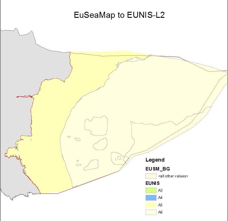
3 Marine ecosystems typology Level 1 Level 2 (MAES, 2013) Level 3 (EUNIS, L2) Marine Marine inlets and transitional waters- lack of significant tides Coastal areas- 0-30m depth, subject of wave disturbance Shelf m depth, below wave disturbance Open ocean- >200m, in Black sea associated with the anaerobic H 2 S zone Depth intervals are based on the Initial assessment of the marine environment, A1. Littoral rock and other hard substrate A2. Littoral sediment A3. Infralittoral rock and other hard substrate A4. Circalittoral rock and other hard substrate A5. Sub-littoral sediment A6. Deep sea-bed A7. Pelagial A8 : Ice-associated marine habitats B3. Rock, cliffs, ledges and shores, inl. Supralittoral X2. Saline coastal lagoons

4
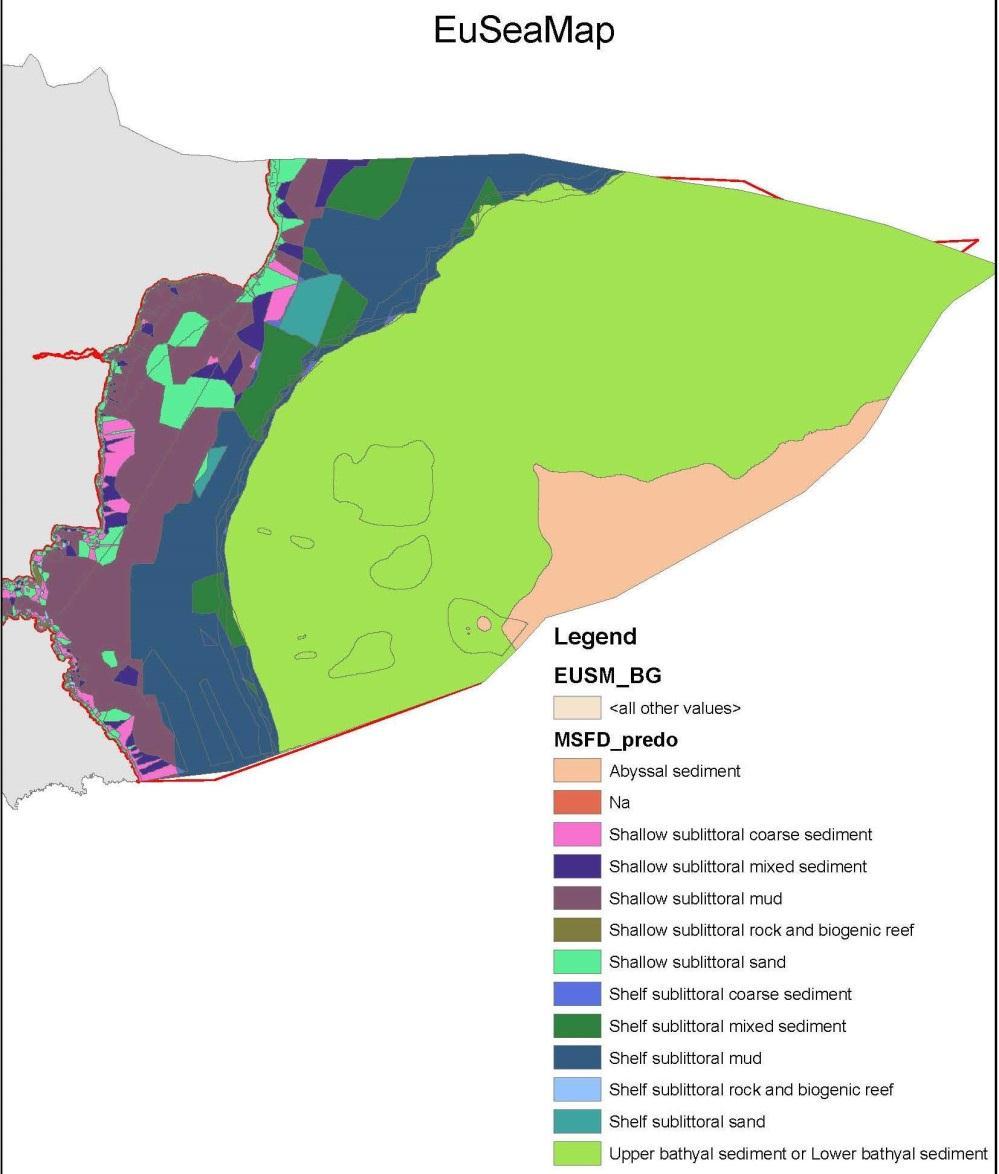
5 Data sources Marine ecosystem typology at Level 3 - national- Initial assessment of marine environment, Natura 2000 mapping, WFD monitoring in coastal water bodies, industry related regional projects (South stream, Burgas-Alexandropoulis), research projects - international- EUSeaMap for benthic broad scale habitats (previously known as predominant), remote sensing, Corine Land Cover dataset (for coastal lagoons-x2), FP7 research projects- PERSEUS, COCONET
6


7
8
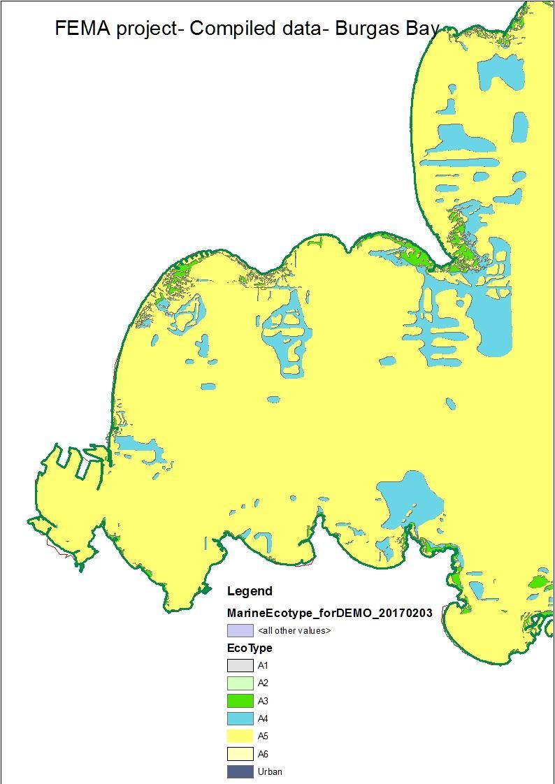
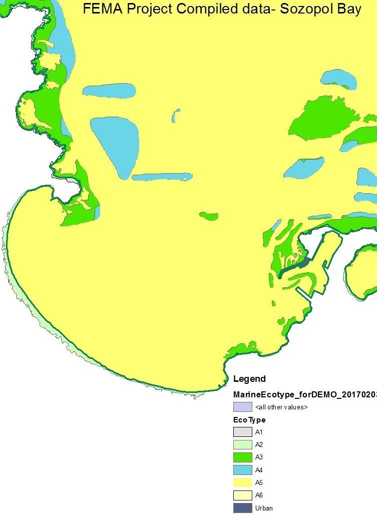
9 Areas comparison EUNIS-L2 FEMA EUSeaMap Difference Types km2 % km2 % km2 A A A A A A TOTAL


10 In-situ verification - via processing of georeferenced SCUBA transects and drone aerophotos А2. Littoral sediments А4. Circalittoral rocks А4. Infralittoral rocks

11 Georeferenced aerophoto mosaic by drone
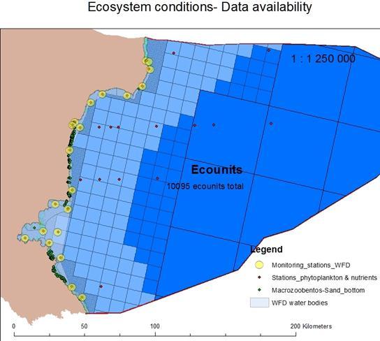
12 Assessment of Ecosystem conditions Data sources WFD monitoring in the coastal water bodies- 1 mile, BQE- macrozoobenthos, phytoplancton, macrophytobenthos Physicochemical quality elements- nutrients, O2, BOD Monitoring of bathing waters Microbial- pathogens Initial assessment of marine environment, 2013 Research projects, FP7- PERSEUS, COCONET, KNOWSEAS Environmental impact assessments, e.g. South stream, Burgas- Alexandropolis pipelines
13

14
15 Parameter Unit Ecosystem Condition Parameters- Short list Assessment scale and score Score Score Score Score Score very bad bad moderate good very good Phytoplankton cell/l > Macroalgae and angiosperms-eei-c Macrozoobentos- M-AMBI EQR EQR < Birds diversity N/area < >100 Fish diversity Shannon- Weaver H Coastal zone A3 habitats <1.834 A5 habitats <1.438 Shelf zone Coastal zone A A Shelf zone m < m m < m Transparency metter > TRIX units < P-PO 4 mg.l > <0.005 N-NH 4 mg.l > <0.008 N-NO 3 mg.l > <0.016 N-NO 2 mg.l > <0.006 BOD-5 mg.l > <3.0 O 2 mg.l < O 2 % - - < >85 Phytoplankton biomas EQR < Chlorophyl A EQR <


16 Mapping ecosystem conditions- Macrozoobenthos in sandy bottom
17 In-situ verification of ecosystem condition- A5- Sublittoral sediments in Sozopol Bay Indicator type Indicator group Indicator Parameter Units Real data Score Real data 2016 Score 2016 Abiotic Water Transparency m P-PO 4, summer mg.l Structural N-NH 4, summer mg.l Biotic Plant diversity Index of ecosystem performance (IP) IP = ni/- ni(max) N-NO 3, summer mg.l Macroalgae and Angiosperms Ecological Evaluation Index (EEI-c) very bad; bad; moderate; good; very good n i n i (max) IP Condition Very Good Very Good EQR
18 Assessment of Ecosystem Services Background - adopted CICES framework, The Common International Classification of Ecosystem Services which links with the framework of the UN System of Environmental-Economic Accounts. - revised as many classes are not relevant in marine environment and to also include specific for the Black sea basin potential services as using H 2 S & methane in fuel cells, salt production, oil and gas production. - data availability- national statistic, scientific papers, research and development projects, etc.

19 Mapping Ecosystem Services, Nutrition- Fish catch- Landings in kg
20 Conclusions: - needed further in-situ studies to verify distribution of all subtypes; - collect more in-situ data for ecosystem conditions according to the MSFD criteria and refinement of the ecosystem condition indicators; - adjustment of ecosystem services indicators framework.
21 Thank you for your attention
Оценка и картиране и на морските екосистемни типове, състояние и услуги в Българските черноморски води общо представяне на проекта
 Оценка и картиране и на морските екосистемни типове, състояние и услуги в Българските черноморски води общо представяне на проекта Венцислав Карамфилов 1, Димитър Беров 1, Стефания Клайн 1, Любомир Димитров
Copernicus for Coastal Zone Monitoring and Management
 Copernicus for Coastal Zone Monitoring and Management DG-Grow, 29 June 2017 User Requirement Perspective: Monitoring of coastal zones, pressures and impacts on nature and people Courtesy: J. Ekebom storm
Crustose algae communities on Baltic infralittoral rock and mixed substrata
 European Red List of Habitats Marine: Baltic Habitat Group Crustose algae communities on Baltic infralittoral rock and mixed substrata Summary This benthic habitat is present throughout the Baltic where
Mapping ecosystem services provided by benthic habitats in the European Atlantic Ocean
 Mapping and Assessment Ecosystem Services and Links to Good Environmental Status Mapping ecosystem services provided by benthic habitats in the European Atlantic Ocean Ibon Galparsoro, Angel Borja and
UNIT 5: ECOLOGY Chapter 15: The Biosphere
 CORNELL NOTES Directions: You must create a minimum of 5 questions in this column per page (average). Use these to study your notes and prepare for tests and quizzes. Notes will be stamped after each assigned
Case Study: Bulgarian part of the Black Sea
 Application of the MESMA Framework. Case Study: Bulgarian part of the Black Sea Schipper C.A. 1 Todorova V. 2, Doncheva V. 2 1 Deltares, P.O.Box 177, 2600 MH Delft, The Netherlands 2 Institute of Oceanology
Unvegetated epifaunal communities on Baltic infralittoral coarse sediment
 European Red List of Habitats Marine: Baltic Habitat Group Unvegetated epifaunal communities on Baltic infralittoral coarse sediment Summary This habitat occurs in all the Baltic Sea subbasins although
Annual algae communities on Baltic infralittoral coarse sediment
 European Red List of Habitats Marine: Baltic Sea Habitat Group Annual algae communities on Baltic infralittoral coarse sediment Summary This habitat is found in all the Baltic Sea subbasins and is especially
Infaunal communities of Baltic upper circalittoral sand not dominated by bivalves
 European Red List of Habitats Marine: Baltic Habitat Group Infaunal communities of Baltic upper circalittoral sand not dominated by bivalves Summary This habitat is typical of upper circalittoral sand
Mapping of marine habitats in shallow coastal areas in Denmark
 6 th Workshop Seabed Acoustics, Rostock, November 14/15, 2013 P11-1 Mapping of marine habitats in shallow coastal areas in Denmark Dr. Zyad Al-Hamdani Geological Survey of Denmark and Greenland - GEUS
BIOLOGICAL OCEANOGRAPHY
 BIOLOGICAL OCEANOGRAPHY AN INTRODUCTION 0 ^ J ty - y\ 2 S CAROL M. LALLI and TIMOTHY R. PARSONS University of British Columbia, Vancouver, Canada PERGAMON PRESS OXFORD NEW YORK SEOUL TOKYO ABOUT THIS VOLUME
Marine biodiversity - PBBT102
 Marine biodiversity - PBBT102 UNIT 1 (2 marks) 1. Define marine biodiversity? 2. How biodiversity is measured? 3. Why many species go extinct every day? 4. What is biodiversity hotspot? 5. What are endemic
Treasure Coast Science Scope and Sequence
 Course: Marine Science I Honors Course Code: 2002510 Quarter: 3 Topic(s) of Study: Marine Organisms and Ecosystems Bodies of Knowledge: Nature of Science and Life Science Standard(s): 1: The Practice of
Macrozoobenthos monitoring
 Macrozoobenthos monitoring Macrozoobenthos is considered as a biological element to assess the ecological quality status in transitional ecosystems Since 2008 a monitoring program was established for the
v=7tat9croynk&feature=youtu.be
 https://www.youtube.com/watch? v=7tat9croynk&feature=youtu.be Malta Summer School 2018 Operational Oceanography for Blue Growth EMODnet in a nutshell: unlocking, and offering access to, European marine
PRINCIPLE OF OCEANOGRAPHY PBBT101 UNIT-1 INTRODUCTION OF OCEANIC ENVIRONMENT. PART-A (2 Marks)
") PRINCIPLE OF OCEANOGRAPHY PBBT101 UNIT-1 INTRODUCTION OF OCEANIC ENVIRONMENT 1. Define marine ecosystem. 2. What is geography? 3. Give two Oceanic zones 4. What is sea? 5. Define oceanography? 6. Enlist
PRINCIPLE OF OCEANOGRAPHY PBBT101 UNIT-1 INTRODUCTION OF OCEANIC ENVIRONMENT 1. Define marine ecosystem. 2. What is geography? 3. Give two Oceanic zones 4. What is sea? 5. Define oceanography? 6. Enlist
Motivations, principles and development of a pan-european approach to describe MPA network coherence in Europe s seas
 Motivations, principles and development of a pan-european approach to describe MPA network coherence in Europe s seas G. Mo 1, S. Agnesi 1, J. Reker 2 1 ISPRA (Rome, Italy) & European Topic Center on Inland
The mapping of habitats: an indispensable tool to the planning and management of protected areas in Catalonia
 The mapping of habitats: an indispensable tool to the planning and management of protected areas in Catalonia Palau de Congressos de Catalunya Barcelona, 27 September 2016 Introduction Agoodcartographic
Infaunal communities in Baltic infralittoral muddy sediment not dominated by bivalves
 European Red List of Habitats Marine: Baltic Habitat Group Infaunal communities in Baltic infralittoral muddy sediment not dominated by bivalves Summary This habitat occurs in shallow areas in all the
Mapping and Assessment of Ecosystems and their Services
 Mapping and Assessment of Ecosystems and their Services ALTER-Net Conference 2013: Science underpinning the EU 2020 Biodiversity Strategy. April 2013 Gent Joachim MAES 1 This presentation is based on the
Overview of Chapter 6
 Overview of Chapter 6 Earth s Major Biomes Aquatic Ecosystems Freshwater ecosystems Estuaries Marine Ecosystems Wildfires and Ecosystems Wildfire unexpected fire in grass, shrub, or forests (a significant
Seabed Habitat Classification Issues Jacques Populus - Ifremer - Brest
 Seabed Habitat Classification Issues Jacques Populus - Ifremer - Brest Classifications of nature types are necessary to provide an explicit view of the seabed on maps, however they are only an imperfect
RED LIST OF EUROPEAN HABITATS. Marine Results Presentation 24 th May, 2016
 RED LIST OF EUROPEAN HABITATS Marine Results Presentation 24 th May, 2016 Geographical scope of the project Habitat Typology One typology for marine and terrestrial At the same time... revision of EUNIS
Classification of Marine Life & Habitats
 Classification of Marine Life & Habitats OCN 201 Biology Lecture 3 Grieg Steward Autotrophs can make the organic building blocks of life starting from carbon dioxde Heterotrophs have to eat organics carbon
Research Background: Researcher Sam Bond taking Sediment Elevation Table (SET) measurements in the marsh. A view of salt marsh hay growing in a marsh
 measurements in the marsh. A view of salt marsh hay growing in a marsh") Name Keeping up with the sea level Featured scientist: Anne Giblin from the Marine Biological Laboratory and the Plum Island Ecosystems Long-Term Ecological Research site Research Background: Salt marshes
Name Keeping up with the sea level Featured scientist: Anne Giblin from the Marine Biological Laboratory and the Plum Island Ecosystems Long-Term Ecological Research site Research Background: Salt marshes
Ms. A. Mormando's Class *
 8 th Grade Science Essential Standard: 8.E.1.1 Explain the structure of the hydrosphere including: Water distribution on Earth; Local river basin and water availability Stream - A stream is a body of water
Discussion paper on spatial units
 Discussion paper on spatial units for the Forum of Experts in SEEA Experimental Ecosystem Accounting 2018 Version: 8 June 2018 Prepared by: SEEA EEA Revision Working Group 1 on spatial units (led by Sjoerd
9/10/ What Shapes an Ecosystem? Biotic and Abiotic Factors
 9/10/14 4-2 What Shapes an Ecosystem? Biology 1 of 39 Ecosystems are influenced by a combination of biological and physical factors. The biological influences on organisms within an ecosystem are called
BIOSPHERE. LITHOSPHERE Source: After Christopherson, 2012, p. 13
 BIOSPHERE LITHOSPHERE Source: After Christopherson, 2012, p. 13 ECOSYSTEM ESSENTIALS 1. Introduction: the ecosystem concept 2. Green plants: the basis for life 3. Abiotic ecosystem components 4. Biotic
Ecosystems and Communities
 Ecosystems and Communities Chapter 4 Section Outline Section 4-1 4 1 The Role of Climate A. What Is Climate? 1. Weather is day to day at a particular time and place 2. Climate is year-to-year averages
Designing Networks of Marine Protected Areas in DFO s Three Atlantic Bioregions
 Designing Networks of Marine Protected Areas in DFO s Three Atlantic Bioregions Presentation for Indigenous Protected Areas Workshop Max Westhead, DFO and Adrian Gerhartz-Abraham, Dalhousie March 29, 2017
EMODnet data. Flanders Marine Institute. Simon Claus. A. Giorgetti, D. Schaap, A. Novellino, A. Pititto, H.Lilis, V. Henry, T.
 EMODnet data Simon Claus A. Giorgetti, D. Schaap, A. Novellino, A. Pititto, H.Lilis, V. Henry, T. Schmitt Flanders Marine Institute EMODnet data themes Types of Data Vocabularies Data Exchange Format Metadata
Introduction: The Gulf of Mexico Alliance. The Gulf GAME project MERMAid and PHINS Results & Conclusions What s next? Examples
 AAG Las Vegas March 25, 2009 Introduction: Ocean governance and Ecosystem-Based Management The Gulf of Mexico Alliance Habitat Identification and Characterization The Gulf GAME project MERMAid and PHINS
Biosphere Biome Ecosystem Community Population Organism
 Ecology ecology - The study of living things and how they relate to their environment Levels of Organization in Ecology organism lowest level one living thing population collection of organisms of the
Curriculum Links AS and A level Field Studies
 Equipment Includes Human Geography Coastal Management Students examine the conflicts that arise from coastal erosion and the options for coastal management. They investigate different types of coastal
Classifying Marine Organisms by how they get their carbon
 Classification of Marine Life & Habitats OCN 201 Biology Lecture 3 1 Classifying Marine Organisms by how they get their carbon Autotrophs - use CO 2 to make organics Who: All plants, some protista, bacteria,
Contents. Preface. IC. Introductory Chapter. 1. The Ocean in the Earth System. Ocean Studies and Pedagogy Acknowledgments
 Contents Preface Ocean Studies and Pedagogy Acknowledgments IC. Introductory Chapter IC.1 Why the Ocean is Important to Us? IC.1.1 Biological Resources IC.1.1.1 Fisheries IC.1.1.2 Other Biological Resources
SIF_7.1_v2. Indicator. Measurement. What should the measurement tell us?
 Indicator 7 Area of natural and semi-natural habitat Measurement 7.1 Area of natural and semi-natural habitat What should the measurement tell us? Natural habitats are considered the land and water areas
4-2 What Shapes an Ecosystem? Slide 1 of 39
 4-2 What Shapes an Ecosystem? 1 of 39 Biotic and Abiotic Factors Biotic and Abiotic Factors Ecosystems are influenced by a combination of biological and physical factors. The biological influences on organisms
Science 8 Unit 1 Test Review Analyze factors that affect productivity and species distribution in marine and fresh water environments.
 Science 8 Unit 1 Test Review How does water shape our world? 1. Define a water system in your own words 2. What is water important for? (3 things at least) 3. What is water made of? Water in our world
Marine Ecology Pacing Guide
 Marine Ecology Pacing Guide Course Description: The focus of the course is the interrelationships among marine organisms and the physical, chemical, geological and biological factors. North Carolina coastal
4-2 What Shapes an Ecosystem?
 Biology 1 of 39 4-2 What Shapes an Ecosystem? 2 of 39 Biotic and Abiotic Factors Biotic and Abiotic Factors Ecosystems are influenced by a combination of biological and physical factors. 3 of 39 1 Biotic
Natura 2000 in the marine environment: state of implementation and next steps
 Life on the blue planet: biodiversity research and the new European marine policies EPBRS European Platform on Biodiversity Research Strategy Porto, Portugal 7-9 November 2007 Natura 2000 in the marine
Subtidal permanently flooded with tidal water. Irregularly exposed surface exposed by tides less often than daily
 Types of Wetlands Tidal Systems COASTAL WETLAND ECOSYSTEMS Tidal Salt Marshes Tidal Freshwater Marshes Mangrove Wetlands Tidal Estuarine Wetland 1 Definition and Formation of Estuaries u Estuary : partially
Types of Wetlands. Tidal Systems
 Types of Wetlands Tidal Systems 1 COASTAL WETLAND ECOSYSTEMS Tidal Salt Marshes Tidal Freshwater Marshes Mangrove Wetlands 2 Tidal Estuarine Wetland 3 Definition and Formation of Estuaries Estuary: : partially
Biophysical Interactions
 1 River Ecology Senior Geography Biophysical Interactions Checking the Pulse of the Hawkesbury River Name 2 River Ecology Senior Geography Senior Geography Outcomes PRELIMINARY COURSE OUTCOMES P2 describes
Quantifying effects of oil on coastal dune vegetation. Thomas Miller and Elise Gornish Biological Science, Florida State University
 Quantifying effects of oil on coastal dune vegetation Thomas Miller and Elise Gornish Biological Science, Florida State University Natural History of Barrier Islands in the Northern Gulf Make up ~70% of
TREASURE COAST SCIENCE SYLLABUS
 Marine Science I Honors 2002510 TREASURE COAST SCIENCE SYLLABUS Year and teacher contact information COMPLETED BY INDIVIDUAL TEACHER Text info here The purpose of this course is to provide exploratory
Purpose of large scale mapping/inventories
 Mapping of benthic habitats in NE Baltic Sea Georg Martin Estonian Marine Institute, University of Tartu & good colleagues from EMI, IAE and CORPI Protecting the marine ecosystem Lessons learned from project
Evolution and Life in the Ocean
 Characteristics of All Living Things Contain matter in a highly organized state Capture, store and transmit energy; all organisms require energy Capable of reproduction Change through time and adapt to
C o p e r n i c u s f o r H i g h r e s o l u t i o n m a p p i n g o f w a t e r q u a l i t y. Copernicus EU
 C o p e r n i c u s f o r H i g h r e s o l u t i o n m a p p i n g o f w a t e r q u a l i t y Copernicus EU Copernicus EU Copernicus EU www.copernicus.eu M o n i t o r i n g o f s e a w a t e r s i n
Cross-border Maritime Spatial Plan for the Black sea - Romania and Bulgaria project
 Cross-border Maritime Spatial Plan for the Black sea - Romania and Bulgaria project in Romania and Bulgaria Plan Presentation A first step in the management of the marine areas of Romania and Bulgaria
BURGAS CASE STUDY: LAND-SEA INTERACTIONS. Dr. Margarita Stancheva
 BURGAS CASE STUDY: LAND-SEA INTERACTIONS Dr. Margarita Stancheva Name of presentation NEED FOR COHERENCE BETWEEN LAND AND SEA ACTIVITIES Name presenter Burgas is the fourth largest city in Bulgaria and
BIOMES. Copyright Cmassengale
 BIOMES Biogeography - study of where organisms live Continental drift - slow motion of continents Dispersal of organisms Movement of organisms from 1 place to another Dispersal is usually caused by wind,
Abiotic Dominant Dominant Factors Plants Animals
 TERRESTRIAL BIOMES Abiotic Dominant Dominant Factors Plants Animals Tropical Rain Forest Hot & wet year round Ferns Woody vines Broad leaved evergreen trees Sloths Jaguars Monkeys Toucans Tropical Dry
Ecosystems Chapter 4. What is an Ecosystem? Section 4-1
 Ecosystems Chapter 4 What is an Ecosystem? Section 4-1 Ecosystems Key Idea: An ecosystem includes a community of organisms and their physical environment. A community is a group of various species that
Investigating the contribution of allochthonous subsidies to kelp forests in central California
 Investigating the contribution of allochthonous subsidies to kelp forests in central California melissa m foley UCSC Institute of Marine Science and Center for Ocean Solutions system connectivity rivers
MESMA: An integrated tool box to support an ecosystem based spatial management of marine areas
 MESMA: An integrated tool box to support an ecosystem based spatial management of marine areas Stelzenmüller, V., Stamford, T., Vassilopoulou, V., Kastanevakis, S., Vincx, M, Vanaverbeke, J., Rabaut, M.,
Science 5 - Sawyer Oceans [Exam ID:6030]
![Science 5 - Sawyer Oceans [Exam ID:6030]](/thumbs/96/126548050.jpg "Science 5 - Sawyer Oceans [Exam ID:6030]") Science 5 - Sawyer Oceans [Exam I:6030] 1 Koa and Neeve are swimming and jumping in the waves at the beach. On which part of the ocean are they standing? Mountain range ontinental rise byssal plain ontinental
Science 5 - Sawyer Oceans [Exam I:6030] 1 Koa and Neeve are swimming and jumping in the waves at the beach. On which part of the ocean are they standing? Mountain range ontinental rise byssal plain ontinental
Chapter 52 An Introduction to Ecology and the Biosphere
 Chapter 52 An Introduction to Ecology and the Biosphere Ecology The study of the interactions between organisms and their environment. Ecology Integrates all areas of biological research and informs environmental
What Lives in the Open Ocean and Where Do They Live?
 Open Ocean 2 Concepts What are some of the organisms in the ocean? How do the physical (abiotic) properties of the ocean define what organisms live there? Standards Addressed HCPS 5.1, 5.2, & 5.3 Duration
CHAPTER 6 & 7 VOCABULARY
 CHAPTER 6 & 7 VOCABULARY 1. Biome 2. Climate 3. Latitude 4. Altitude 5. Emergent layer 6. Epiphyte 7. Understory 8. Permafrost 9. Wetland 10.Plankton 11.Nekton 12.Benthos 13.Littoral zone 14.Benthic zone
UNSD SEEA-EEA revision 2020
 UNSD SEEA-EEA revision 2020 Area 1: Spatial units; introduction Sjoerd Schenau, Patrick Bogaart, Edwin Horlings London group meeting, October 2018 Overview Spatial units in SEEA EEA Main revision issues
4. In areas where tectonic plates collide, the seafloor has deep. 5. In areas where tectonic plates separate, the seafloor has mid- ocean
 Name Date Hour Table Chapter 14 Lesson One- General Directions: Use the word bank below to complete each statement. NOT all terms are used. abyssal plains brackish water condensation energy freshwater
Capturing a Holistic Understanding of a Large Marine Ecosystem The NOAA Gulf of Mexico Data Atlas
 Capturing a Holistic Understanding of a Large Marine Ecosystem The NOAA Gulf of Mexico Data Atlas NODC / National Coastal Data Development Center gulfalas.noaa.gov Need: data that contribute to long-term
GIS and Coastal Nutrients Luke Cole
 GIS and Coastal Nutrients Luke Cole Human population density has been widely utilized as a valid predictor of terrestrial nitrogen loads into marine systems. As 50% of the world s population lives within
Lab 7: Sedimentary Structures
 Name: Lab 7: Sedimentary Structures Sedimentary rocks account for a negligibly small fraction of Earth s mass, yet they are commonly encountered because the processes that form them are ubiquitous in the
FEAST (Feature Activity Sensitivity Tool)
") FEAST (Feature Activity Sensitivity Tool) Dr Suz Henderson Coastal and Marine Ecosystems Unit (CMEU), SNH, Inverness. http://www.marine.scotland.gov.uk/feast/ FEAST sensitivity assessment FEAST enables
FEAST (Feature Activity Sensitivity Tool) Dr Suz Henderson Coastal and Marine Ecosystems Unit (CMEU), SNH, Inverness. http://www.marine.scotland.gov.uk/feast/ FEAST sensitivity assessment FEAST enables
Classification of geodiversity in a natural tidal inlet system based on topobathymetric LiDAR data
 Classification of geodiversity in a natural tidal inlet system based on topobathymetric LiDAR data MSc Thesis, September 2015 Mikkel Skovgaard Andersen DANCORE, 2/10-2015, Copenhagen Content 1. Motivation
Physiography Ocean Provinces p. 1 Dimensions p. 1 Physiographic Provinces p. 2 Continental Margin Province p. 2 Deep-Ocean Basin Province p.
 Physiography Ocean Provinces p. 1 Dimensions p. 1 Physiographic Provinces p. 2 Continental Margin Province p. 2 Deep-Ocean Basin Province p. 2 Mid-Ocean Ridge Province p. 3 Benthic and Pelagic Provinces
Hawaii Content and Performance Standards Science Grade: 9 - Adopted: TOPIC: Science, Technology, and Society
 Main Criteria: Hawaii Content and Performance Standards Secondary Criteria: Subjects: Science, Social Studies Grade: 9 Correlation Options: Show Correlated Hawaii Content and Performance Standards HI.SC.BS.
Interrelationships. 1. Temperature Wind Fire Rainfall Soil Type Floods Sunlight Altitude Earthquake
 Interrelationships Abiotic Factors A. A Partial List 1. Temperature Wind Fire Rainfall Soil Type Floods Sunlight Altitude Earthquake B. Aquatic Adaptations 1. Pumping salt out a. Salt water fish 2. Pumping
Marine ecosystem mapping at the Prince Edward Islands
 Marine ecosystem mapping at the Prince Edward Islands Biodiversity Planning Forum NBA special session June 2018 R Adams, C von der Meden, A Dayaram, K Sink, A Lombard, A Bosman, M Dopolo, F Fourie, L Harris,
Marine Spatial Planning as an important tool for implementing the MSFD
 Marine Spatial Planning as an important tool for implementing the MSFD Risto Kalliola Tallinn, Nov. 16 th 2012 DEPARTMENT OF GEOGRAPHY AND GEOLOGY University of Turku, Finland Ten principles to provide
Coastal Oceanography. Coastal Oceanography. Coastal Waters
 Coastal Oceanography Coastal Oceanography 95% of ocean life is in coastal waters (320 km from shore) Estuaries and wetlands are among most productive ecosystems on Earth Major shipping routes, oil and
Setting Priorities for Eelgrass Conservation and Restoration. Robert Buchsbaum Massachusetts Audubon Society
 Setting Priorities for Eelgrass Conservation and Restoration Robert Buchsbaum Massachusetts Audubon Society Eelgrass habitat values A rich, productive habitat for many marine organisms Nursery habitat
Bringing together harmonized EUNIS seabed habitat geospatial information for the European Seas
 Please replace with an image illustrating your report and align it with this one. Please remove this text box from your cover. Bringing together harmonized EUNIS seabed habitat geospatial information for
Coastal and Marine Ecological Classification Standard (CMECS)
") Coastal and Marine Ecological Classification Standard (CMECS) Mark Finkbeiner NOAA Coastal Services Center Presented at the International Workshop on Seabed Mapping Methods and Technology 18 October 2012
Coastal and Marine Ecological Classification Standard (CMECS) Mark Finkbeiner NOAA Coastal Services Center Presented at the International Workshop on Seabed Mapping Methods and Technology 18 October 2012
Role of macrofauna and the impacts of natural and anthropogenic disturbance on sediment biogeochemical processes (Module 3)
") Biogeochemistry, macronutrient and carbon cycling in the benthic layer (BMCC) WP2 Role of macrofauna and the impacts of natural and anthropogenic disturbance on sediment biogeochemical processes (Module
Biogeochemistry, macronutrient and carbon cycling in the benthic layer (BMCC) WP2 Role of macrofauna and the impacts of natural and anthropogenic disturbance on sediment biogeochemical processes (Module
Catastrophic Events Impact on Ecosystems
 Catastrophic Events Impact on Ecosystems Hurricanes Hurricanes An intense, rotating oceanic weather system with sustained winds of at least 74 mph and a welldefined eye Conditions for formation: Warm water
OCEANOGRAPHY CURRICULUM. Unit 1: Introduction to Oceanography
 Chariho Regional School District - Science Curriculum September, 2016 OCEANOGRAPHY CURRICULUM Unit 1: Introduction to Oceanography OVERVIEW Summary In this unit students will be introduced to the field
Environmental Science
 Environmental Science A Study of Interrelationships Cui Jiansheng Hebei University of Science and Technology CH06 Kinds of Ecosystems and Communities Chapter Objectives After reading this chapter, you
Significant Ecological Marine Area Assessment Sheet
 Significant Ecological arine Area Assessment Sheet Name: Eastern Bay of Island Biogenic Soft Sediment Complex Summary: The semi-sheltered areas between the central islands of the Eastern Bay of Islands
Moreton Bay and Key Geographic Concepts Worksheet
 Moreton Bay and Key Geographic Concepts Worksheet The Australian Curriculum: Geography draws on seven key geographic concepts: place scale space environment change interconnection sustainability They are
Aim and objectives Components of vulnerability National Coastal Vulnerability Assessment 2
 ASSESSING THE UTILITY OF GEOMORPHIC SENSITIVITY MAPPING ON THE ILLAWARRA COAST Pamela Abuodha, Christina Baker, Chris Sharples, Darren Skene and Colin Woodroffe Geoquest Research Centre, University of
Name Hour. Section 4-1 The Role of Climate (pages 87-89) What Is Climate? (page 87) 1. How is weather different from climate?
 What Is Climate? (page 87) 1. How is weather different from climate?") Name Hour Section 4-1 The Role of Climate (pages 87-89) What Is Climate? (page 87) 1. How is weather different from climate? 2. What factors cause climate? The Greenhouse Effect (page 87) 3. Circle the
Name Hour Section 4-1 The Role of Climate (pages 87-89) What Is Climate? (page 87) 1. How is weather different from climate? 2. What factors cause climate? The Greenhouse Effect (page 87) 3. Circle the
Theme 1, Working Group B: Conservation objectives for habitats Working Group reporting
 Theme 1, Working Group B: Conservation objectives for habitats Working Group reporting Annabelle Aish (MNHN) and Nicolas Fournier (Oceana) Marine Natura 2000 Biogeographical Kick-off seminar Working group
Biomes of the World What is a Biome?
 Biomes of the World What is a Biome? A large, relatively distinct terrestrial region with characteristic Climate Soil Plants Animals Interacting landscapes 1 Terrestrial Biomes Using Precipitation And
Understanding Oceans, Gulfs & Tides
 SCS-2005-13 Water and Me Series Understanding s, Gulfs & Tides Monty C. Dozier Assistant Professor and Extension Water Resources Specialist The dictionary defines the ocean as the whole body of saltwater
Name Hour. Chapter 4 Review
 Name Hour Chapter 4 Review 1. The average, year-after-year conditions of temperature and precipitation within a particular region are its weather. climate. greenhouse effect. d. biotic factors. 2. The
Organisms in the Ocean
 Oceans Objective 8.E.1.2 Summarize evidence that Earth's oceans are a reservoir of nutrients, minerals, dissolved gases, and life forms: estuaries, marine ecosystems, upwelling, and behavior of gases in
Jacqueline M. Grebmeier Chesapeake Biological Laboratory University of Maryland Center for Environmental Science, Solomons, MD, USA
 Update on the Pacific Arctic Region Synthesis Activity as part of the ICES/PICES/PAME Working Group on Integrated Ecosystem Assessment of the Central Arctic Ocean (WGICA) Jacqueline M. Grebmeier Chesapeake
Ecological mapping using satellite imagery: an Abu Dhabi case study Middle East Geospatial Forum 16 th February 2015
 Ecological mapping using satellite imagery: an Abu Dhabi case study Middle East Geospatial Forum 16 th February 2015 Richard Flemmings rf@proteusgeo.com About Proteus Formed in UAE 2011 We specialise in
American Harris mud crab Rhithropanopeus harrisii
 American Harris mud crab Rhithropanopeus harrisii (Gould, 1841) in the Gulf of Gdańsk (southern Baltic Sea): distribution, population structure and basic physiological processes Joanna Hegele-Drywa Alien
Eutrophication (H01.05), Contaminant pollution (H01.05), Contaminant pollution (H03),
, Contaminant pollution (H01.05), Contaminant pollution (H03),") English name: Code in HUB: Submarine structures made by leaking gases 1180 Characteristic species: Polycirrus norwegicus, Kellia suborbicularis Past and Current Threats (Habitat directive Future Threats
English name: Code in HUB: Submarine structures made by leaking gases 1180 Characteristic species: Polycirrus norwegicus, Kellia suborbicularis Past and Current Threats (Habitat directive Future Threats
Almost of Earth is covered by water. On a map, the continents appear as huge islands surrounded by a vast global ocean.
 Earth s Oceans & Ocean Floor Date: Feelin Blue What are Earth s five main oceans? Almost of Earth is covered by water. On a map, the continents appear as huge islands surrounded by a vast global ocean.
Benthic habitat mapping: a synopsis of methodologies and approaches. Dr. Craig Brown University of Ulster
 Benthic habitat mapping: a synopsis of methodologies and approaches Dr. Craig Brown University of Ulster Technological advances in remote sensing Insitu sampling Improving technology Single beam acoustics/video
MARK SCHEME for the October/November 2015 series 9693 MARINE SCIENCE
 CAMBRIDGE INTERNATIONAL EXAMINATIONS Cambridge International Advanced Subsidiary Level MARK SCHEME for the October/November 2015 series 9693 MARINE SCIENCE 9693/01 Paper 1 (AS Structured Questions), maximum
Tides. Tides are the slow, periodic vertical rise and fall of the ocean surface.
 PART 2 Tides Tides are the slow, periodic vertical rise and fall of the ocean surface. Tide is a giant wave caused by gravitational pull of the Moon and Sun on the rotating Earth. The gravitational pull
Science 8 - Water Systems Test - Chapters 1-2
 Science 8 - Water Systems Test - Chapters 1-2 Multiple Choice (30 marks) Identify the choice that best completes the statement or answers the question. 1. What percentage represents the amount of fresh