Classification of geodiversity in a natural tidal inlet system based on topobathymetric LiDAR data
|
|
|
- Linda Knight
- 5 years ago
- Views:
Transcription


1 Classification of geodiversity in a natural tidal inlet system based on topobathymetric LiDAR data MSc Thesis, September 2015 Mikkel Skovgaard Andersen DANCORE, 2/ , Copenhagen
2 Content 1. Motivation of mapping in the shallow water zone 2. Introduction to geodiversity and topobathymetric LiDAR 3. Study area: Knudedyb, Danish Wadden Sea 4. LiDAR survey 5. Part 1: Processing a Digital Elevation Model (DEM) I. Method: Processing pipeline II. Results: DEM + accuracy assessment III. Discussion: Water surface detection and the dead zone 6. Part 2: Morphological classification I. Method: Two classification methods II. Results: Geomorphometric and morphological classifications III. Discussion: Method and application 7. Conclusions 8. Perspectives


3 Motivation: - why map the shallow water zones? Regulating permissions for fishing and dredging Navigation purposes Archaeological investigations Knowledge on natural coastal processes Predictions of future environmental changes EU aim: Retain good environmental status in EU marine waters by 2020

4 Enhedens navn Introduction: Geodiversity Definition: The natural range (diversity) of geological (rocks, minerals, fossils), geomorphological (land form, processes) and soil features. It includes their assemblages, relationships, properties, interpretations and systems. (Gray, M. (2004): Geodiversity valuing and conserving abiotic nature) Geosphere Biosphere Ecosystem management


5 Introduction: Topobathymetric LiDAR Nadir α air α water Snell s Law: sinα air sinα water = c air c water = n water n air

6 Introduction: Topobathymetric LiDAR Power Power Time Time Dead zone Water Land
7 Introduction: Aim Part 1: Processing a Digital Elevation Model (DEM) in the transition zone between land and water Part 2: Classifying morphological features based on the processed DEM


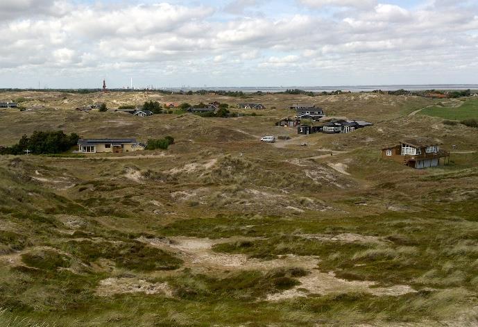
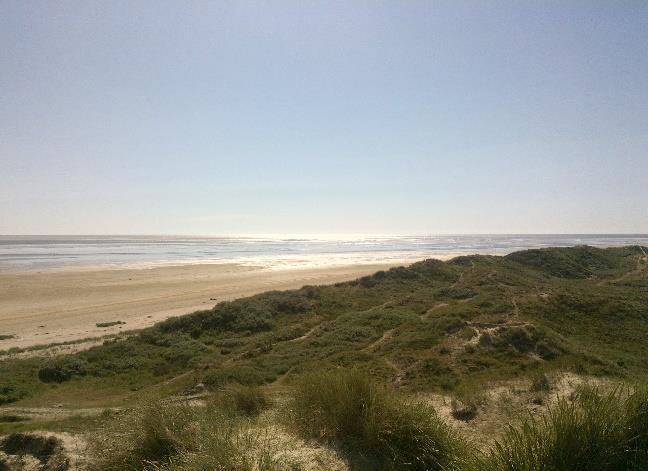
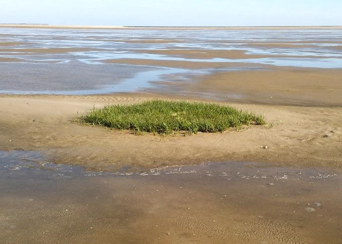
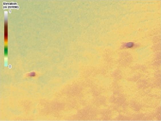
8 Enhedens navn Study Area Fanø Challenges: Changing water level (tides) Ponds on the tidal flat High turbidity Fanø Mandø 10 km


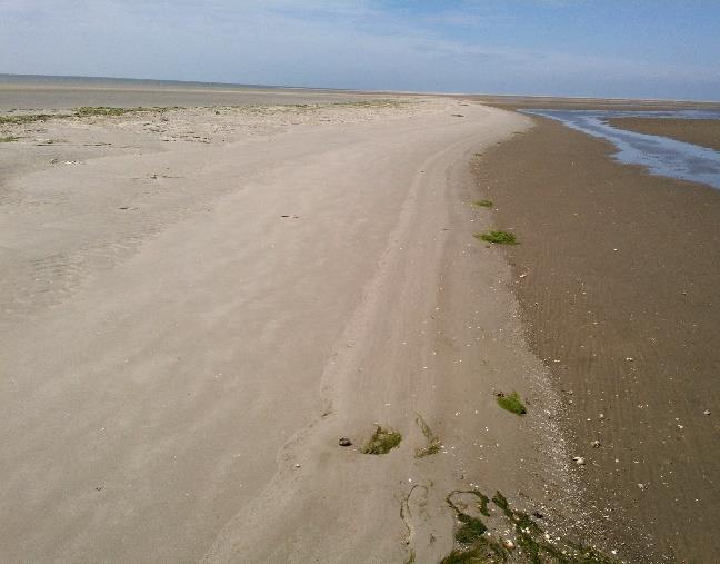
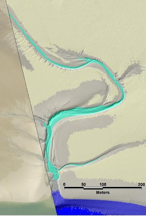
9 Enhedens navn Study Area Fanø A B A B C E F D C D E F
 Department")

10 Surveys: LiDAR survey (May 2014) Department of Geosciences and Natural Resource Management
11 Enhedens navn Part 1 Processing a DEM
12 Methods Enhedens navn
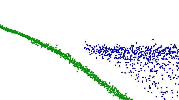
13 Methods: Creating a topobathymetric DEM Raw data Strip adjustment Filtering Point cloud To DEM Refraction correction Water surface detection

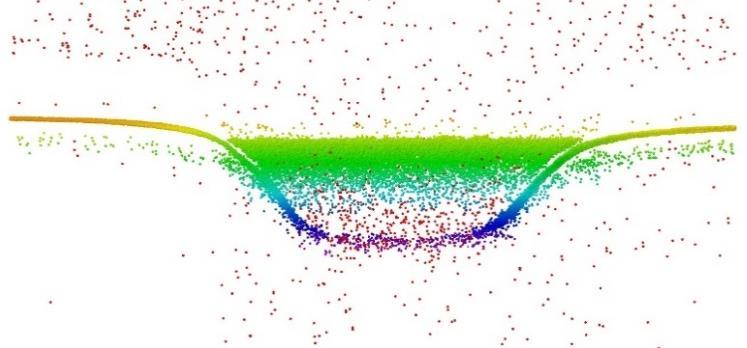
14 Methods: Creating a topobathymetric DEM - Filtering Elevation (DVR 90) 0 m 4 m metres Water surface detection Refraction correction

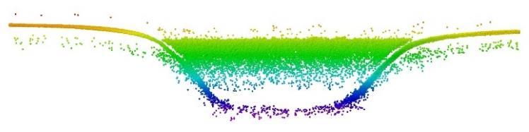
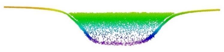
15 Methods: Creating a topobathymetric DEM Water surface detection 1. LiDAR Point cloud 2. Shallow surface & Deep surface 3. Water surface elevation 4. Water surface
16 Methods: Creating a topobathymetric DEM Refraction correction α water = sin 1 sinα air n air n water n air = n water = 1.33 α air = 20 ± 1
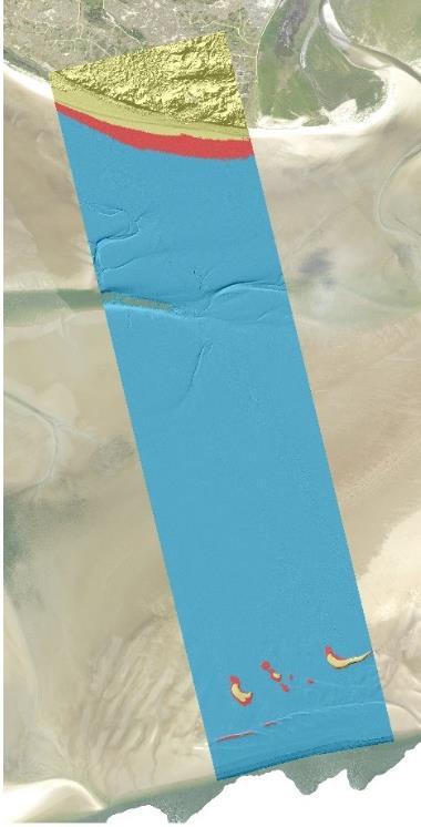
17 Results Enhedens navn

 > 2 1 0-1")
18 Results: Topobathymetric DEM Elevation (m DVR90) >

 > 2 1 0-1")
19 Results: Topobathymetric DEM Elevation (m DVR90) >
 21")

20 Results: Elevation (m) 21 Topobathymetric DEM 10 Elevation (m DVR90) >


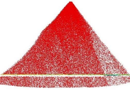
21 Results: Vertical accuracy and precision 2.5 x 1.25 x 0.8 m 0.92 x 0.92 x 0.30 m GCPs LiDAR points LiDAR points Accuracy = ±8.1cm Precision = ±7.6cm Precision = ±3.8cm
22 Discussion Enhedens navn

23 Discussion: Water surface detection method + Simple concept, easy to repeat + Water surface also covers the dead zone + Indications of reliable results Waves and sloping water surface are not modeled - Ponds are not modeled Involves manual processing
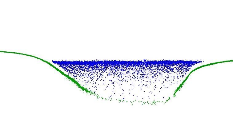
24 Discussion: The dead zone 25 cm Mean Low Water Mean Water Level Mean High Water
25 Discussion: The dead zone 6 cm 25 cm
26 Enhedens navn Part 2 Morphological classification
27 Enhedens navn Methods Classifying geomorphometry Classifying morphological features

 Fine")
28 Methods: Classifying geomorphometry Department of Geosciences and Natural Resource Management Benthic Terrain Modeler Bathymetric Positioning Index (BPI) Fine scale BPI Broad scale BPI


29 Methods: Classifying geomorphometry Department of Geosciences and Natural Resource Management DEM Classification classes: Fine scale BPI Broad scale BPI Small scale crest Large scale crest Depression Slope Flat Slope
30 Methods: Classifying morphological features
31 Methods: Classifying morphological features
32 Methods: Classifying morphological features
33 Methods: Classifying morphological features
34 Methods: Classifying morphological features
35 Methods: Classifying morphological features
36 Results Enhedens navn

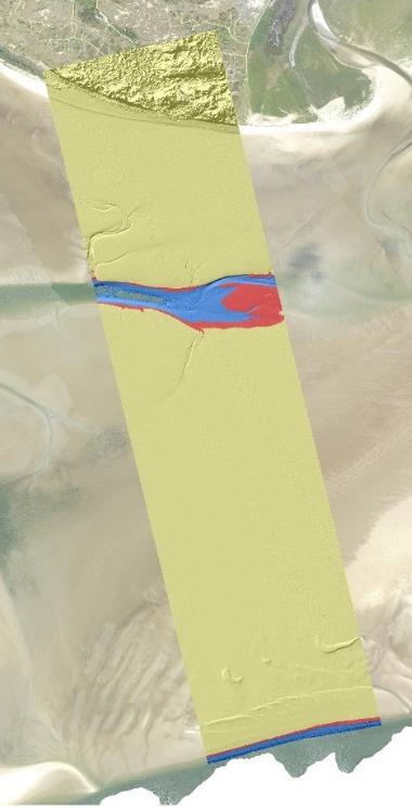
37 Results: Geomorphometric classification Classification DEM
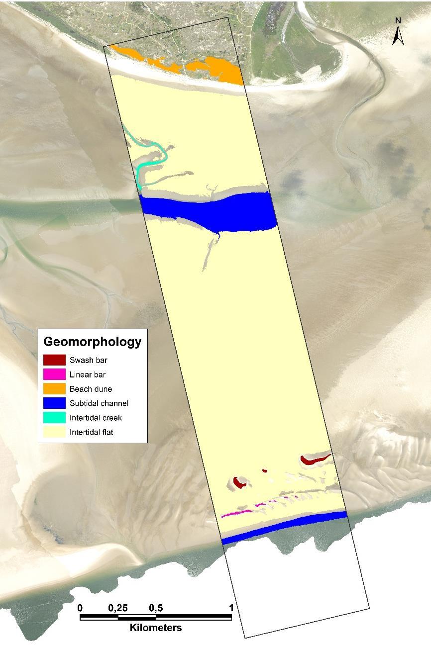
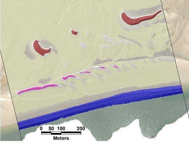
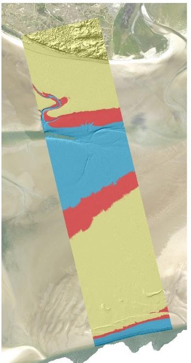
38 Results: Morphological classification Morphology
39 Discussion Enhedens navn
40 Enhedens navn Discussion: Morphological classification method + Successful classification of morphological features at different spatial scales + Straight forward concept Specifically developed to suit this study area Subjective scale determination

41 Enhedens navn Discussion: - what is it good for? Knowledge on morphology and processes in a challenging environment Knowledge on the physical foundation in ecosystem management Geosphere Biosphere
42 Conclusions Proposed method for processing raw topobathymetric LiDAR data New method for water surface detection A seamless topobathymetric DEM of 0.5 m resolution is created Maximum LiDAR penetration depth: 3 m Dead zone: 25 cm Vertical accuracy (95% confidence level) = ±8.1 cm Classification of 6 morphological classes: Swash bars, linear bars, beach dunes, intertidal flats, intertidal creeks and subtidal channels High-resolution topobathymetric LiDAR provides a promising tool for mapping morphological features at different spatial scales in the coastal zone
43 Enhedens navn Perspectives Full-waveform LiDAR processing Closing the gap in the dead zone Classification of materials Multi-temporal LiDAR surveying Improve point cloud processing pipeline More automatic workflow Modeling of inclined water surface (and waves)

44 Thank you Department of Geosciences and Natural Resource Management
Mapping of marine habitats in shallow coastal areas in Denmark
 6 th Workshop Seabed Acoustics, Rostock, November 14/15, 2013 P11-1 Mapping of marine habitats in shallow coastal areas in Denmark Dr. Zyad Al-Hamdani Geological Survey of Denmark and Greenland - GEUS
ON THE EVOLUTION OF A HOLOCENE BARRIER COAST
 ON THE EVOLUTION OF A HOLOCENE BARRIER COAST Response to sea-level change and sediment supply DANCORE Seminar 2014 COADAPT - Danish Coasts and Climate Adaptation Flooding Risk and Coastal Protection Mikkel
Annual transport rates at two locations on the fore-slope.
 Sediment Transport by Currents Fore-slope Sediment transport rates and sediment concentrations were computed from the hydrodynamic model runs as well as from direct measurements of current velocities at
Flood screening using the Lidar-based Danish Elevation model
 Flood screening using the Lidar-based Danish Elevation model Eva Bøgh and Thorbjørn Nielsen Office for Data Cooperation (DSA) Side 1 Danish Lidar-based Digital Elevation Model (DEM) The point cloud (2014/2015):
Mapping, monitoring, and modeling: USGS Coastal and Marine Geology activities along the Northeast coast
 Mapping, monitoring, and modeling: USGS Coastal and Marine Geology activities along the Northeast coast Coastal and Marine Geology Program Woods Hole Coastal and Marine Science Center St. Petersburg Coastal
The Marine Environment
 The Marine Environment SECTION 16.1 Shoreline Features In your textbook, read about erosional landforms, beaches, estuaries, longshore currents, and rip currents. For each statement below, write true or
The Marine Environment
 The Marine Environment SECTION 16.1 Shoreline Features In your textbook, read about erosional landforms, beaches, estuaries, longshore currents, and rip currents. For each statement below, write or. 1.
Lidar-derived Hydrography as a Source for the National Hydrography Dataset
 Lidar-derived Hydrography as a Source for the National Hydrography Dataset Lidar-Derived Hydrography, Bathymetry, and Topobathymetry in the National Hydrography Dataset and 3-Dimensional Elevation Program
EMERGENCY PLANNING IN NORTHERN ALGERIA BASED ON REMOTE SENSING DATA IN RESPECT TO TSUNAMI HAZARD PREPAREDNESS
 EMERGENCY PLANNING IN NORTHERN ALGERIA BASED ON REMOTE SENSING DATA IN RESPECT TO TSUNAMI HAZARD PREPAREDNESS Barbara Theilen-Willige Technical University of Berlin, Institute of Applied Geosciences Department
Coastal and Marine Ecological Classification Standard (CMECS)
") Coastal and Marine Ecological Classification Standard (CMECS) Mark Finkbeiner NOAA Coastal Services Center Presented at the International Workshop on Seabed Mapping Methods and Technology 18 October 2012
Coastal and Marine Ecological Classification Standard (CMECS) Mark Finkbeiner NOAA Coastal Services Center Presented at the International Workshop on Seabed Mapping Methods and Technology 18 October 2012
REPORT. Coastal Inundation Hazard Zone Mapping. Addendum to Coastal Protection Areas Re-assessment Stage Two
 REPORT Coastal Inundation Hazard Zone Mapping Addendum to Coastal Protection Areas Re-assessment Stage Two Prepared for Prepared by Date Job Number 851833 Distribution: (FILE) 1 copy 1 copy Table of contents
e-soter at scale 1: for the Danube Basin Vincent van Engelen
 e-soter at scale 1:250 000 for the Danube Basin Vincent van Engelen Underlying the SOTER methodology is the identification of areas of land with a distinctive, often repetitive, pattern of landform, lithology,
The Application of CHRIS Data to the Multi-temporal & Multi-angular Study of Near-shore Marine Bathymetry
 The Application of CHRIS Data to the Multi-temporal & Multi-angular Study of Near-shore Marine Bathymetry PhD/Postgrad students: Libby Boak Stacy Mitchell AJ Lau Indrie Miller School of Biological, Earth,
Sea-level Rise on Cape Cod: How Vulnerable Are We? Rob Thieler U.S. Geological Survey Woods Hole, MA
 Sea-level Rise on Cape Cod: How Vulnerable Are We? Rob Thieler U.S. Geological Survey Woods Hole, MA Outline Sea-level and coastal processes Past sea-level change Predictions for the future Coastal responses
GIS Mapping of Croatian Landform Diversity Using the Geomorphons Approach
 GEOHERITAGE, GEOINFORMATION AND CARTOGRAPHY GIS Mapping of Croatian Landform Diversity Using the Geomorphons Approach Matjaž ŠTANFEL, Dražen TUTIĆ University of Zagreb, Faculty of Geodesy mastanfel@geof.hr,
Bathymetry Measures the vertical distance from the ocean surface to mountains, valleys, plains, and other sea floor features
 1 2 3 4 5 6 7 8 9 10 11 CHAPTER 3 Marine Provinces Chapter Overview The study of bathymetry determines ocean depths and ocean floor topography. Echo sounding and satellites are efficient bathymetric tools.
Sea Level Rise and the Scarborough Marsh Scarborough Land Trust Annual Meeting April 24, 2018
 Sea Level Rise and the Scarborough Marsh Scarborough Land Trust Annual Meeting April 24, 2018 Peter A. Slovinsky, Marine Geologist Maine Geological Survey Funded by: 50% 40% Figure modified from Griggs,
Bedform characterization through 2D spectral analysis
 Journal of Coastal Research SI 64 781-785 ICS2011 (Proceedings) Poland ISSN 0749-0208 Bedform characterization through 2D spectral analysis A. Lefebvre, V. B. Ernstsen and C. Winter MARUM University of
Biosphere Biome Ecosystem Community Population Organism
 Ecology ecology - The study of living things and how they relate to their environment Levels of Organization in Ecology organism lowest level one living thing population collection of organisms of the
Lidar data in water resources applications. Paola Passalacqua CE 374K Lecture, April 5 th, 2012
 Lidar data in water resources applications Paola Passalacqua CE 374K Lecture, April 5 th, 2012 Airborne Lidar Airborne laser altimetry technology (LiDAR, Light Detection And Ranging) provides high-resolution
GLY Coastal Geomorphology Notes
 GLY 4734 - Coastal Geomorphology Notes Dr. Peter N. Adams Spring 2011 2 Coastal Classification In this lecture, we discuss some successful classification schemes of the coastal landscape, and pay particular
Global Survey of Organized Landforms: Recognizing Linear Sand Dunes
 Global Survey of Organized Landforms: Recognizing Linear Sand Dunes P. L. Guth 1 1 Department of Oceanography, US Naval Academy 572C Holloway Rd, Annapolis MD 21402 USA Telephone: 00-1-410-293-6560 Fax:
Chapter Overview. Bathymetry. Measuring Bathymetry. Measuring Bathymetry
 CHAPTER 3 Marine Provinces Chapter Overview The study of bathymetry determines ocean depths and ocean floor topography. Echo sounding and satellites are efficient bathymetric tools. Most ocean floor features
Predicting the Evolution of Tidal Channels in Muddy Coastlines
 Predicting the Evolution of Tidal Channels in Muddy Coastlines Sergio Fagherazzi Department of Earth Sciences and Center for Computational Science Boston University, Boston MA 02215 Phone: (617) 353-2092
Beach Profile Changes using RTK GPS : A Case Study Maizati Binti Mohamed Amin 1, a, Radzuan Sa ari 1, b, Muhammad Azril Hezmi 1, c
 Beach Profile Changes using RTK GPS : A Case Study Maizati Binti Mohamed Amin 1, a, Radzuan Sa ari 1, b, Muhammad Azril Hezmi 1, c 1 Faculty of Civil Engineering, Universiti Teknologi Malaysia, Malaysia
An analysis on the relationship between land subsidence and floods at the Kujukuri Plain in Chiba Prefecture, Japan
 doi:10.5194/piahs-372-163-2015 Author(s) 2015. CC Attribution 3.0 License. An analysis on the relationship between land subsidence and floods at the Kujukuri Plain in Chiba Prefecture, Japan Y. Ito 1,
Geol 117 Lecture 18 Beaches & Coastlines. I. Types of Coastlines A. Definition:
 I. Types of Coastlines A. Definition: 1. Shore = narrow zone where ocean meets land (e.g. beach) 2. Coast is a broad area where both ocean and land processes act a. Includes onshore marshes, dunes, sea
Marine Geophysical Methods: What Can and Cannot Be Done to Iden8fy Hazards to Dredging & Marine Construc8on
 Marine Geophysical Methods: What Can and Cannot Be Done to Iden8fy Hazards to Dredging & Marine Construc8on Marine Geophysics Sham or Savior? Seen alternatively as the silver bullet or snake oil, marine
Work Package 5: Signal Processing and Seafloor Classification
 Work Package 5: Signal Processing and Seafloor Classification Jarosław Tęgowski and Karolina Trzcińska Marine Geophysics Lab. Institute of Oceanography University of Gdańsk, Poland Kick-Off Meeting, Kiel,
Map shows 3 main features of ocean floor
 Map shows 3 main features of ocean floor 2017 Pearson Education, Inc. Chapter 3 Marine Provinces 2017 Pearson Education, Inc. 1 Chapter 3 Overview The study of bathymetry determines ocean depths and ocean
Possibilities of LIDAR in the shallow waters of the Baltic Sea and it s application for habitat modeling
 Possibilities of LIDAR in the shallow waters of the Baltic Sea and it s application for habitat modeling Michael Haldin Natural Heritage Services / Metsähallitus Markku Viitasalo SYKE BACKGROUND LIDAR
WHAT IS THE EARTH MADE OF? LITHOSPHERE AND HYDROSPHERE
 UNIT 8 WHAT IS THE EARTH MADE OF? LITHOSPHERE AND HYDROSPHERE TABLE OF CONTENTS 1 THE STRUCTURE OF THE EARTH... 2 2 THE FORMATION OF THE RELIEF: INTERNAL AND EXTERNAL FORCES.... 2 2.1 Internal forces:
IMPACTS OF SEA LEVEL RISE in Bangkok, Thailand
 IMPACTS OF SEA LEVEL RISE in Bangkok, Thailand Hiroaki KAKIUCHI Chuo Mapping Co., Ltd Takekazu AKAGIRI, Takahito KUROKI, Tohru NAGAYAMA Geographic Survey Institute, Min. of Construction, JAPAN Shunji MURAI,
Create your own map for tidepooling, beach field trips, boating, camping, kayaking, fishing, and exploring the beaches in Southcentral Alaska.
 Create your own map for tidepooling, beach field trips, boating, camping, kayaking, fishing, and exploring the beaches in Southcentral Alaska. Here s an opportunity to download and customize your own free
COASTAL QUATERNARY GEOLOGY MAPPING FOR NSW: EXAMPLES AND APPLICATIONS
 COASTAL QUATERNARY GEOLOGY MAPPING FOR NSW: EXAMPLES AND APPLICATIONS A Troedson Geological Survey of New South Wales Abstract Detailed geological mapping of the coastal plains of regional NSW was undertaken
Fugro Geospatial: Turning Spatial Data into Knowledge
 Fugro Geospatial: Turning Spatial Data into Knowledge 2016 Fugro Geospatial, GIS and Consultants Locations Variety of Collection Platforms Traditional Mapping Traditional Mapping Imagery Photogrammetric
Aim and objectives Components of vulnerability National Coastal Vulnerability Assessment 2
 ASSESSING THE UTILITY OF GEOMORPHIC SENSITIVITY MAPPING ON THE ILLAWARRA COAST Pamela Abuodha, Christina Baker, Chris Sharples, Darren Skene and Colin Woodroffe Geoquest Research Centre, University of
ENVIRONMENTAL GEOSCIENCE UNIFORM SYLLABUS
 ENVIRONMENTAL GEOSCIENCE UNIFORM SYLLABUS The Association of Professional Engineers and Geoscientists of the Province of British Columbia Note: 1. This Syllabus May Be Subject To Change 2. These Courses
Treasure Coast Science Scope and Sequence
 Course: Marine Science I Honors Course Code: 2002510 Quarter: 3 Topic(s) of Study: Marine Organisms and Ecosystems Bodies of Knowledge: Nature of Science and Life Science Standard(s): 1: The Practice of
Long-term estuary processes and morphological change
 Long-term estuary processes and morphological change Professor Ken Pye with contributions from Dr. Simon Blott and Dr. Daphne van der Wal Department of Geology Available top-down methods relying on data
Watershed concepts for community environmental planning
 Purpose and Objectives Watershed concepts for community environmental planning Dale Bruns, Wilkes University USDA Rural GIS Consortium May 2007 Provide background on basic concepts in watershed, stream,
SIF_7.1_v2. Indicator. Measurement. What should the measurement tell us?
 Indicator 7 Area of natural and semi-natural habitat Measurement 7.1 Area of natural and semi-natural habitat What should the measurement tell us? Natural habitats are considered the land and water areas
Sediment and Sedimentary rock
 Sediment and Sedimentary rock Sediment: An accumulation of loose mineral grains, such as boulders, pebbles, sand, silt or mud, which are not cemented together. Mechanical and chemical weathering produces
PRINCIPLE OF OCEANOGRAPHY PBBT101 UNIT-1 INTRODUCTION OF OCEANIC ENVIRONMENT. PART-A (2 Marks)
") PRINCIPLE OF OCEANOGRAPHY PBBT101 UNIT-1 INTRODUCTION OF OCEANIC ENVIRONMENT 1. Define marine ecosystem. 2. What is geography? 3. Give two Oceanic zones 4. What is sea? 5. Define oceanography? 6. Enlist
PRINCIPLE OF OCEANOGRAPHY PBBT101 UNIT-1 INTRODUCTION OF OCEANIC ENVIRONMENT 1. Define marine ecosystem. 2. What is geography? 3. Give two Oceanic zones 4. What is sea? 5. Define oceanography? 6. Enlist
TOWNSVILLE STORM SURGE HYPOTHETICAL: TECHNICAL SPECIFICATIONS
 TOWNSVILLE STORM SURGE HYPOTHETICAL: TECHNICAL SPECIFICATIONS Stuart Mead, Mahesh Prakash and Fletcher Woolard CSIRO Mathematics, Informatics and Statistics, Private Bag 33, Clayton South, VIC 3168, Australia
Does the SDCP need inputs from geology?
 The British Geological Survey s Experience and Expertise in Supporting Projects such as the Sirte Depression Connection Project David Ovadia Director of International Kingsley Dunham Centre Keyworth Nottingham
Sediment and sedimentary rocks Sediment
 Sediment and sedimentary rocks Sediment From sediments to sedimentary rocks (transportation, deposition, preservation and lithification) Types of sedimentary rocks (clastic, chemical and organic) Sedimentary
Marine biologists have identified over 250,000 marine species. This number is constantly increasing as new organisms are discovered.
 A wide variety of organisms inhabit the marine environment. These organisms range in size from microscopic bacteria and algae to the largest organisms alive today blue whales, which are as long as three
TPDES: Soil, Erosion and Sedimentation Methods
 SAWS TPDES: Soil, Erosion and Sedimentation Methods Philip Handley Supervisor-Resource Protection & Compliance August 25, 2014 TPDES: Soil, Erosion and Sedimentation Methods Soil Common term: Dirt Common
BIOLOGICAL OCEANOGRAPHY
 BIOLOGICAL OCEANOGRAPHY AN INTRODUCTION 0 ^ J ty - y\ 2 S CAROL M. LALLI and TIMOTHY R. PARSONS University of British Columbia, Vancouver, Canada PERGAMON PRESS OXFORD NEW YORK SEOUL TOKYO ABOUT THIS VOLUME
Paleo Lab #4 - Sedimentary Environments
 Paleo Lab #4 - Sedimentary Environments page - 1. CHARACTERISTICS OF SEDIMENT Grain size and grain shape: The sizes and shapes of sedimentary particles (grains) are modified considerably during their transportation
Fatmagül Batuk, Ozan Emem Department of Geodesy and Photogrammetry Engineering Tolga Görüm, Erkan Gökaan Natural Sciences Research Center
 Fatmagül Batuk, Ozan Emem Department of Geodesy and Photogrammetry Engineering Tolga Görüm, Erkan Gökaan Natural Sciences Research Center Landforms Landform term as used to denote a portion of the earth
Use of Elevation Data in NOAA Coastal Mapping Shoreline Products. Coastal GeoTools April 1, 2015
 Use of Elevation Data in NOAA Coastal Mapping Shoreline Products Coastal GeoTools April 1, 2015 - NOAA s Coastal Mapping Program & CUSP - Shoreline Uses, Delineation Issues, Definitions - Current Extraction
AirborneHydroMapping. New possibilities in bathymetric and topographic survey
 AirborneHydroMapping New possibilities in bathymetric and topographic survey NIRAS og AHM, projekt for Statens Kartverk Dataíndsamling i kystsonen med LiDAR system NIRAS, DANMARK Etablert i 1956 Ingeniørfirma
Subtidal permanently flooded with tidal water. Irregularly exposed surface exposed by tides less often than daily
 Types of Wetlands Tidal Systems COASTAL WETLAND ECOSYSTEMS Tidal Salt Marshes Tidal Freshwater Marshes Mangrove Wetlands Tidal Estuarine Wetland 1 Definition and Formation of Estuaries u Estuary : partially
Geomorphometric analysis and drainage network for the territory of Republic of Croatia
 Geomorphometric analysis and drainage network for the territory of Republic of Croatia Marta Pokupić, Matej Varga, prof. dr. sc. Tomislav Bašić Faculty of Geodesy, University of Zagreb 13th International
Types of Wetlands. Tidal Systems
 Types of Wetlands Tidal Systems 1 COASTAL WETLAND ECOSYSTEMS Tidal Salt Marshes Tidal Freshwater Marshes Mangrove Wetlands 2 Tidal Estuarine Wetland 3 Definition and Formation of Estuaries Estuary: : partially
Summary Visualizations for Coastal Spatial Temporal Dynamics
 Summary Visualizations for Coastal Spatial Temporal Dynamics October 24 2011 Providence, RI Sidharth Thakur 1, Laura Tateosian 2, Helena Mitasova, Eric Hardin, and Margery Overton 1. sthakur@renci.org,
Using Topography Position Index for Landform Classification (Case study: Grain Mountain)
") Bulletin of Environment, Pharmacology and Life Sciences Bull. Env. Pharmacol. Life Sci., Vol 3 [11] October 2014: 33-39 2014 Academy for Environment and Life Sciences, India Online ISSN 2277-1808 Journal
Bulletin of Environment, Pharmacology and Life Sciences Bull. Env. Pharmacol. Life Sci., Vol 3 [11] October 2014: 33-39 2014 Academy for Environment and Life Sciences, India Online ISSN 2277-1808 Journal
Subaqueous Soils A A New Frontier in Soil Survey. By Jim Turenne
 Subaqueous Soils A A New Frontier in Soil Survey By Jim Turenne http://nesoil.com.sas Subaqueous History Traditional soil survey conducted on land. Not a lot of work in wetlands and tidal marshes until
Stability of a sand spit due to dredging in an adjacent creek
 Stability of a sand spit due to dredging in an adjacent creek Rupali S. Patgaonkar, D. Ilangovan, P. Vethamony*, M. T. Babu, S. Jayakumar and M. D. Rajagopal National Institute of Oceanography, Dona Paula,
Intelligent Marine and Coastal Mapping Data
 O Intelligent Marine and Coastal Mapping Data When you need mapping data that is fit for purpose, in the right format, accurate and up to date Marine Themes Vector Marine Themes DEM Raster Charts XL Electronic
Lower 8.3 Miles of the Lower Passaic River Operable Unit 2 Presentation to The Passaic River Community Advisory Group. September 14, 2017
 Lower 8.3 Miles of the Lower Passaic River Operable Unit 2 Presentation to The Passaic River Community Advisory Group September 14, 2017 Agenda Pre-Design Investigation (PDI) Status Geophysical, Bathymetric,
Missouri Educator Gateway Assessments
 Missouri Educator Gateway Assessments FIELD 019: EARTH SCIENCE June 2014 Content Domain Range of Competencies Approximate Percentage of Test Score I. Science and Engineering Practices 0001 0003 18% II.
Flood protection structure detection with Lidar: examples on French Mediterranean rivers and coastal areas
 Flood protection structure detection with Lidar: examples on French Mediterranean rivers and coastal areas Céline Trmal 1,a, Frédéric Pons 1 and Patrick Ledoux 1 1 Cerema, Direction Territoriale Méditerranée,
Positional accuracy of the drainage networks extracted from ASTER and SRTM for the Gorongosa National Park region - Comparative analysis
 Positional accuracy of the drainage networks extracted from ASTER and SRTM for the Gorongosa National Park region - Comparative analysis Tiago CARMO 1, Cidália C. FONTE 1,2 1 Departamento de Matemática,
Dynamic preservation of the coastline
 Dynamic preservation of the coastline Content Introduction The Dutch coastal defence by dynamic processes Data collection Management of the sand resources Growing importance of marine sand and gravel resources
The Systems Approach. Alun Williams, ABPmer
 The Systems Approach Alun Williams, ABPmer Overview What is A Systems Approach? Behavioural / Qualitative Modelling? System Definition / Mapping (Behavioural Statements Objective) What is a Systems Approach?
NAME: GEL 109 Final Winter 2010
 GEL 109 Final Winter 2010 1. The following stratigraphic sections represents a single event followed by the slow accumulation of background sedimentation of shale. Describe the flows that produced the
South Florida Coastal Storm Surge and Mapping Study
 South Florida Coastal Storm Surge and Mapping Study Presented by Christopher Bender, Ph.D., P.E., D.CE June 2, 2015 Presentation Overview FEMA risk studies outline Overview South Florida surge study Work
Redwood City Harbor, California, Navigation Improvement Feasibility Study. Appendix D. Geotechnical Engineering. DRAFT April 2015
 1 Redwood City Harbor, California, Navigation Improvement Feasibility Study Appendix D Geotechnical Engineering DRAFT April 2015 2 Contents 1 Purposes of Report... 3 2 Background... 3 3 References and
OCEANOGRAPHY CURRICULUM. Unit 1: Introduction to Oceanography
 Chariho Regional School District - Science Curriculum September, 2016 OCEANOGRAPHY CURRICULUM Unit 1: Introduction to Oceanography OVERVIEW Summary In this unit students will be introduced to the field
Earth / Environmental Science. Ch. 14 THE OCEAN FLOOR
 Earth / Environmental Science Ch. 14 THE OCEAN FLOOR The Blue Planet Nearly 70% of the Earth s surface is covered by the global ocean It was not until the 1800s that the ocean became an important focus
3.0 ROBERTS BANK TIDAL FLAT MORPHOLOGY
 Vancouver Port Authority Northwest Hydraulic Consultants Ltd. /Triton Consultants Ltd. Roberts Bank Container Expansion File: 33863 Coastal Geomorphology Study - 19 - November 2004 3.0 ROBERTS BANK TIDAL
Stormwater Inlet Sediment Traps
 Stormwater Inlet Sediment Traps SEDIMENT CONTROL TECHNIQUES Photo 1 Kerb inlet Photo 2 Field (drop) inlet Table 1 provides the recommended default classification of various sediment control systems suitable
Soil erosion susceptibility and coastal evolution: examples in southern New Caledonia
 Pacific Island Countries GIS /RS User Conference Soil erosion susceptibility and coastal evolution: examples in southern New Caledonia Pascal DUMAS et Olivier COHEN University of New-Caledonia (EA 4242/
Carbon Sequestration Potential from Coastal Wetlands Restoration Sites
 Carbon Sequestration Potential from Coastal Wetlands Restoration Sites Insert then choose Picture select your picture. Right click your picture and Send to back. Paul Krause, Alyssa Beach Emily Cooper,
Marine environment monitoring : The basic requirements to support Marine Renewable Energies
 Marine environment monitoring : The basic requirements to support Marine Renewable Energies SHOM in brief SHOM is the French Government agency in charge of Hydrography and Oceanography SHOM s vocation
GY 402: Sedimentary Petrology
 UNIVERSITY OF SOUTH ALABAMA GY 402: Sedimentary Petrology Lecture 5: Bedform Development (Flume Studies) Instructor: Dr. Douglas W. Haywick Today s Lecture 1. What s a flume? 2. Traction induced bed forms
Predicting the Evolution of Tidal Channels in Muddy Coastlines
 Predicting the Evolution of Tidal Channels in Muddy Coastlines Sergio Fagherazzi Address Department of Earth Sciences and Center for Computational Science, Boston University, Boston MA 02215 Phone: 617-353-2092
Quantifying Coastal Evolution using Remote Sensing Approaches
 Quantifying Coastal Evolution using Remote Sensing Approaches Sojan Mathew, Linh Truong Hong, Xavier Pellicer*, Colman Gallagher University College Dublin Geological Survey of Ireland* INFOMAR SEMINAR,
ENGRG Introduction to GIS
 ENGRG 59910 Introduction to GIS Michael Piasecki March 17, 2014 Lecture 08: Terrain Analysis Outline: Terrain Analysis Earth Surface Representation Contour TIN Mass Points Digital Elevation Models Slope
Appendix E: Cowardin Classification Coding System
 Appendix E: Cowardin Classification Coding System The following summarizes the Cowardin classification coding system and the letters and numbers used to define the USFWS NWI wetland types and subtypes:
Regional-scale understanding of the geologic character and sand resources of the Atlantic inner continental shelf, Maine to Virginia
 Regional-scale understanding of the geologic character and sand resources of the Atlantic inner continental shelf, Maine to Virginia Workshop on Dredging, Beach Nourishment and Bird Conservation Atlantic
Integrating LiDAR data into the workflow of cartographic representation.
 Integrating LiDAR data into the workflow of cartographic representation. Cartographic Workflow I. 1 2 3 4 5 Surveying Vector (Nat. GDB) GPS, Laser Range Finder Yes/ No Scanning old maps LiDARflights Capture
Name: Date: Class: Louisiana: Our History, Our Home Chapter 1: Louisiana s Geography - Section 2: Natural Regions Guided Reading
 Instructions: Read the section and complete each item with words from the passages in this section. 1. The diversity of Louisiana s can surprise residents and visitors alike. 2. Physical geography is concerned
From seafloor geomorphology to predictive habitat mapping: progress in applications of biophysical data to ocean management.
 From seafloor geomorphology to predictive habitat mapping: progress in applications of biophysical data to ocean management. Peter T. Harris Geoscience Australia, Canberra ACT, Australia Currently seconded
Remote Sensing and Geographic Information System (GIS) Based Analysis of Historic Resources
 Based Analysis of Historic Resources") World War II Additional Material Remote Sensing and Geographic Information System (GIS) Based Analysis of Historic Resources By Nicole Vernon and Patrick O Day, GANDA Remote Sensing and Geographic Information
World War II Additional Material Remote Sensing and Geographic Information System (GIS) Based Analysis of Historic Resources By Nicole Vernon and Patrick O Day, GANDA Remote Sensing and Geographic Information
Monitoring The Sand Extraction On The Belgian Continental Shelf
 Monitoring The Sand Extraction On The Belgian Continental Shelf Methodology, Results And Expectations K. Degrendele and M. Roche Within the framework of a sustainable exploitation of the mineral resources
2 nd Japan and Republic of Korea LiDAR Survey Symposium
 2 nd Japan and Republic of Korea LiDAR Survey Symposium 2010 年 9 月 20 日 Prof. Woosug Cho wcho@inha.ac.kr Spacematics Lab Department of Civil Engineering Inha University Presentation on Current Status in
GLY 2000 Earth and Environmental Systems NS (3) AS GLY GLY 2010 Dynamic Earth: Introduction to Physical Geology NS (3) AS GLY
 AS GLY GLY 2010 Dynamic Earth: Introduction to Physical Geology NS (3) AS GLY") GLY 2000 Earth and Environmental Systems NS (3) AS GLY May substitute for GLY 2010 for geology majors. This course examines the geology of the earth and the environment, using an earth systems approach
GLY 2000 Earth and Environmental Systems NS (3) AS GLY May substitute for GLY 2010 for geology majors. This course examines the geology of the earth and the environment, using an earth systems approach
Topographic Maps and Landforms Geology Lab
 Topographic Maps and Landforms Geology Lab Ray Rector: Instructor Today s Lab Activities 1) Discussion of Last Week s Lab 2) Lecture on Topo Maps and Elevation Contours 3) Construct Topographic Maps and
CONCEPTUAL AND TECHNICAL CHALLENGES IN DEFINING FLOOD PLANNING AREAS IN URBAN CATCHMENTS
 CONCEPTUAL AND TECHNICAL CHALLENGES IN DEFINING FLOOD PLANNING AREAS IN URBAN CATCHMENTS C Ryan 1, D Tetley 2, C Kinsey 3 1 & 2 Catchment Simulation Solutions, NSW 3 Co-ordinator Stormwater and Structural
Planning for the Future of Humboldt Bay: Sea Level Rise, Sediment Management, Sand Spits and Salt Marshes. Joel Gerwein
 Planning for the Future of Humboldt Bay: Sea Level Rise, Sediment Management, Sand Spits and Salt Marshes Joel Gerwein Introduction to Humboldt Bay Setting Economy, community, and environment Sediment
GIS USE IN THE STUDY OF ESTUARINE SOILS AND SEDIMENTS Margot K. Payne NRS 509 November 30, 2005
 GIS USE IN THE STUDY OF ESTUARINE SOILS AND SEDIMENTS Margot K. Payne NRS 509 November 30, 2005 Throughout the world, estuaries are not only some of the most ecologically productive environments, but are
Harnessing the Power of Earth System Science for Developing Science Practices and Crosscutting Concepts
 Harnessing the Power of Earth System Science for Developing Science Practices and Crosscutting Concepts Roberta Johnson, Richard Jones, Joe Monaco, Wendy Van Norden, Michael Passow, National Earth Science
Miami-Dade County Technical Update Meeting South Florida Coastal Study. May 11, 2016
 Miami-Dade County Technical Update Meeting South Florida Coastal Study May 11, 2016 Welcome and Introductions FEMA Region IV Christina Lindemer Technical Lead Production and Technical Services (PTS) Contractor
Monitoring of sediment dynamics during disposal of dredged harbour sediment in Port of Esbjerg, Denmark
 Monitoring of sediment dynamics during disposal of dredged harbour sediment in Port of Esbjerg, Denmark Ulrik Lumborg, DHI Jacob Vested, DHI Signe Marie Ingvardsen, Kystdirektoratet Agenda Port of Esbjerg
Australian Coastal Councils Conference
 Australian Coastal Councils Conference 11 March 2015 Estimating Future Coastal Inundation and Erosion Hazards Dr Andrew McCowan Dr Christine Lauchlan-Arrowsmith Warwick Bishop Background Victorian Future
COBRA Cable Site Investigation in the Wadden Sea, Denmark
 NGM 2016 Reykjavik Proceedings of the 17 th Nordic Geotechnical Meeting Challenges in Nordic Geotechnic 25 th 28 th of May COBRA Cable Site Investigation in the Wadden Sea, Denmark L. Klinkby COWI, Denmark,