TPDES: Soil, Erosion and Sedimentation Methods
|
|
|
- Anna Oliver
- 5 years ago
- Views:
Transcription


1 SAWS TPDES: Soil, Erosion and Sedimentation Methods Philip Handley Supervisor-Resource Protection & Compliance August 25, 2014 TPDES: Soil, Erosion and Sedimentation Methods
2 Soil Common term: Dirt Common Science Facts: It s all over your site Three Primary Ingredients of soil -Sand -Silt -Clay Soil Type on your site-identifiable (NRCS-SCS County Soil Survey) Soil (sediment) is a recognized pollutant Page 2
3 National Resource Conservation Service National Web Soil Survey If you need specific, local soil data, go to the website provided below and navigate to your specific desired location. If you have some basic GIS use skills you will have success with this program. It is reasonably easy and has a number of information Data sets that are valuable engineering tools Page 3
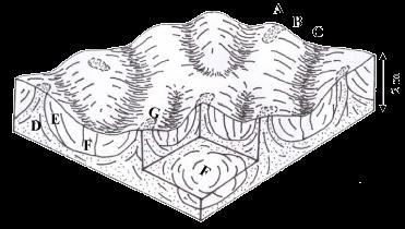
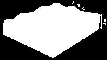
4 Soil Characterization Page 4
5 Soil Characteristics Page 5

6 Soil Type Classification NOTE: It is rare to find a pure soil type Most Soils consists Of various percentages Of Sand Silt Clay Page 6
7 Is Soil a Pollutant? Per USEPA, soil is the number one Pollutant on the EPA pollutant list. WHY? Pollutants such as hydrocarbons, liquid pollutants, metals and other chemicals attach themselves to soil particles Soil density in water (turbidity) reduces oxygen levels and creates other biological changes to habitat in living waters (fish and other biological life) Soil transports to natural waters by storm water runoff Page 7
8 Erosion and Sediment Control Is there a difference Between Erosion and Sediment Control? Page 8
9 The Difference Erosion: is were the soil particles begin separation from the surface horizon of the mantle and transport by storm water down slope. Sediment: is the accumulation of soil particles in a settlement area where all the Soil particles collect together at the bottom of a slope Page 9
10 So.. Where does Erosion Begin? Page 10


11 The Rain Drop Raindrop typical size: 1/16 to 1/4 dia. Fall velocity: 18 ft/sec. or about 20 mph Page 11
12 Raindrop Impact on Soil (example diagram) Splash Pattern Page 12


13 Erosion The Detachment of soil particles from the surface horizon layer of soil due to the volume and force of storm water runoff flowing across non-vegetated or non-covered natural soil mantle/surface horizon. Sheet Rill Gully Stream Bank Erosion Erosion Erosion Erosion Page 13

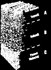
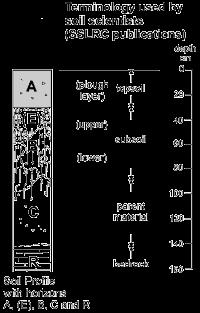
14 Erosion (Soil Horizons Eroded) August 25, 2014 Second Horizon Soil First Horizon Soil Page 14

15 Where did all the Top Soil Go??? To the MS4 = Enforcement August 25, 2014 Page 15


16 Erosion control The prevention of soil particles detachment and reducing The volume of storm water runoff through the use of practices such as minimizing land disturbing activities, maintaining vegetative cover or substituting for lack of growing vegetation by mulching or applying blankets, Erosion control blankets/matting or some type of cover on disturbed or exposed soil mantle/horizon. Straw Cover Hydro Mulching Matting Page 16
 August 25, 2014 Page")
17 Erosion Control (Erosion Mats) August 25, 2014 Page 17
 August 25, 2014 Page 18")
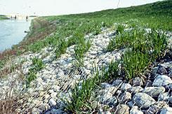
18 Erosion Control (Grassy Filter Strip) August 25, 2014 Page 18


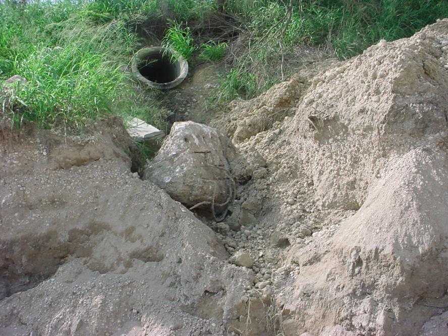
19 Erosion Control (Scour and Solutions) August 25, 2014 Page 19


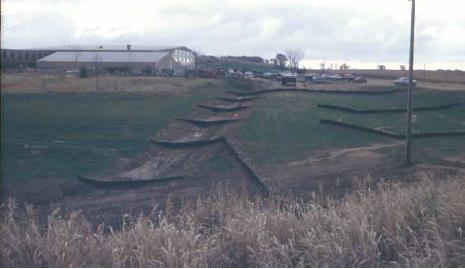
20 Velocity Control Velocity controls are used to reduce the erosion forces Of concentrated storm water flow on a construction site. Practices can include tracking or roughening slopes, rock check dams and other types of check dams and diversions. Tracking Soil Roughening Straw log Check Dams Silt Fence Diversion Page 20
 August 25, 2014 Page")
21 Velocity Control (Silt Fence Placement) August 25, 2014 Page 21


22 Sediment Detached soil particles moving in the erosion process, Transported hydraulically in storm water runoff. Page 22
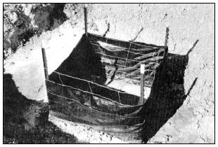
23 Sediment Control Trapping detached soil particles that are being Transported to ensure they are deposited on site To prevent damage to other properties and to stop Pollution to receiving waters. Trapping detached soil particles is achieved by such Practices as silt fence installation, berms, filter socks And sediment control berms. Page 23
24 1 foot August 25, 2014 Soil Class Settlement Times Sand Silt Clay 38 seconds = 1 foot 33 minutes = 1 foot 230 days = 1 foot Page 24
25 Soil Translated to TIME August 25, 2014 Soil Percent Seconds Minutes Hours Days Sand Silt Clay 0 19,872, ,200 5, Page 25

26 Stoke s Law August 25, 2014 Page 26


27 Sediment Control (Silt Fence Installation) Page 27

28 Sediment Control (Berms) Rock Check Dam Compost Filter Berm Page 28

")

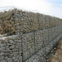
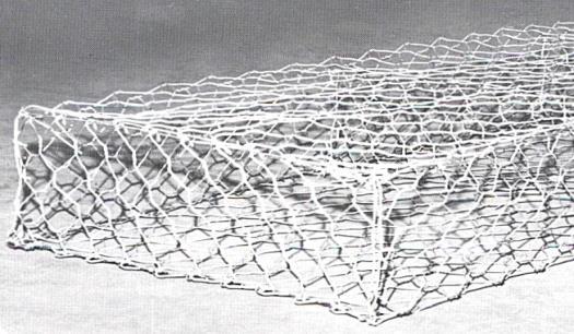
29 Sediment Control (Rock Gabions) August 25, 2014 Page 29


30 Sediment Control (Basins) Page 30

")
31 Sediment Control (Filter Socks) Page 31


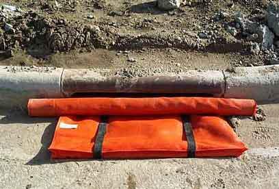
32 Sediment Control (Sediment Bag) August 25, 2014 Page 32
 (C")
33 Sediment Control (Construction Exit) (C Page 33

34 Sediment Control (Inlet Protection) August 25, 2014 Page 34
35 Pollutant Control (Concrete Washout Pit) Page 35
36 Storm Water Pollution Prevention Plans (SWPPP) and Best Management Practices (BMP s) Page 36
37 Why Predict Their Performance? August 25, 2014 Historically Start with a plan that meets the permit requirements and modify it as the plans failures become apparent. Future Start with a plan that will meet Performance Based requirements. Results Better protection of the environment Reduced cost Better relations between regulated and regulators Page 37


38 Current Sedimentation Control Design If the control fails get rid of it? or Add more of it? Page 38

39 Add More of It? August 25, 2014 Page 39

40 Add More of It? August 25, 2014 Page 40
41 Predict the Performance August 25, 2014 Understand what is happening at the control! We have sediment laden water entering the control. We should have ponding of the runoff. Sedimentation will be occurring if we have ponding. Most likely runoff will be exiting the control. Page 41
42 Sedimentation August 25, 2014 What is the one thing that we can look to that will give us a conclusive prediction of the effectiveness of a sedimentation control? Time (Time of concentration to pool sediment laden water allowing settlement) Page 42
43 Effects of Time August 25, 2014 When runoff is detained for a sufficient amount of time, the sediment will settle out of the storm water runoff and will not exit the site. If the runoff exits the control prior to the required settling time, sediment will exit the control with the runoff. Page 43
44 What Do We Know So Far? August 25, 2014 Time is the key Provide enough time and you can remove the sediment. The sedimentation time required is determined by soil type. Each control will have a unique soil type therefore each control will have a unique required sedimentation time. Flow rate will determine the time it will take to fill the sedimentation pool based on the pool volume of the control. Page 44
45 The Problem With Soil Sand, Silt, and Clay Most of the time soil has all three in it. August 25, 2014 Clay being the biggest challenge for sedimentation control design. Most of the time we cannot control what type of soil is on the site. Sometimes the soil changes. Page 45
46 1 Foot August 25, 2014 Remember the Soil settlement model? Sand Silt Clay 38 seconds = 1 foot 33 minutes = 1 foot 230 days = 1 foot Page 46
47 Onsite Control Location Location of the control on the site Determines the drainage area of the control Soil type in the drainage area Required sedimentation time Amount of runoff draining to the control Topography of the drainage area Amount of runoff draining to the control Volume of water detain by the control August 25, 2014 Page 47
48 Page 48
 Page")
49 Need to install triangle and rectangle (more storage) Page 49
50 12 Page 50
51 24 Page 51
52 Design for Maintenance August 25, 2014 Predict the volume of water you need to pool. Predict the sediment volume. Provide a storage volume equal to or greater than the total of both. Page 52
53 Construction Site: 43,500 S.F. (1 Acre = 43,560) Site Dimensions: 435 long by 100 wide = 43,500 s.f. 1 Yr./5 min. (0.54 inch) Storm event 43,500 X 0.54 = 23,522 C.F. of stormwater runoff Containment areas (Silt Fence) 100 X 100 X 1.5 = 15,000 C.F. 120 X 100 X1.5 /2= 9,000 C.F. Total Containment= 24,000 C.F. Construction Site Containment Profile View (n.t.s.) 435 (site length) Sediment Control 18 High Containment Page 53
54 100 August 25, 2014 Construction Site: 43,500 S.F. (1 Acre=43,560) Site Dimensions: 435 long by 100 wide = 43,500 s.f. 1 Yr./5 min. (0.54 inch) Storm event 43,500 X 0.54 = 23,522 C.F. of stormwater runoff Containment area (Sediment Basin w/skimmer) 100 X 70 X 3.5 deep pond = 23,800 C.F. Total Containment= 23,800 C.F. Construction Site Profile View (n.t.s.) Construction site Plan View (n.t.s.) Skimmer Page 54
55 Construction Site: 43,500 S.F. (1 Acre=43,560) Small Site Dilemma Considering a current EPA Sediment Basin requirement to contain a 2 year, 24 hour storm event (Bexar Co. = 3.70 inches) Our 435 X 100 = 43,500 S.F. Construction site experiencing a 3.70 Rain Event would produce a need to contain 160,950 C.F. of stormwater runoff This would require this construction site (if it were flat in elevation) to enclose the entire site with a sediment control BMP and the entire site would be ponding stormwater runoff (435 X 100 X 3.70 = 160,950 C.F.) Not Practical Page 55
56 10 Acre Project Site (435,600 S.F.) 2 Year, 24 Hour storm event (Bexar Co. =3.70 inches) 435,600 S.F. Site X 3.70 rain event will produce 1,611,720 C.F. of stormwater runoff A Sediment Pond with a skimmer device that is 500 X 500 X 7 deep can contain 1,750,000 For a large site, containing a 2 Year, 24 Hour storm event is Practical Page 56

57 Location and Topography (Sometimes, less in the right place is more think strategic!) August 25, 2014 Page 57
58 Current Permit vs. ELG s Current permit Erosion and sediment controls must be designed to retain sediment on-site to the extent practicable with consideration for local topography, soil type, and rainfall. Effluent Limit Guidelines (ELG s) No consideration for on-site conditions. No gray area of to the extent practicable Meet the required standard.??? NTU (Nephelometric Turbidity Units) August 25, 2014 Page 58
59 Summary Current NPDES Currently SWPPP s are designed to meet Extent Practical SWPPP Permitted operators rely primarily on Sediment Control Designers do not consider soil types & sediment loss in SWPPP design SWPPP are living documents (BMP failure prompts modification) Future NPDES Future EPA ELG will require SWPPP design to be Performance Based To control sediment, design will need more focus on erosion control Erosion control will minimize sediment in stormwater runoff Sediment control will be designed to contain and filter and eliminate sediment discharge into the MS4 Stormwater discharge water from construction sites will require testing (turbidity or TSS?) and will have to meet specific ELG targets Page 59
 as your project changes WPAP s are approved plans")
60 Who Decides on your BMP s? August 25, 2014 SWPPP s are living documents subject to change (by you) as your project changes WPAP s are approved plans with specific BMP requirements & permanent BMP s can only change by an approved modification Page 60
61 SAWS TPDES: Soil, Erosion and Sedimentation Methods Philip Handley Supervisor-Resource Protection & Compliance August 25, 2014 TPDES: Soil, Erosion and Sedimentation Methods
Continuing Education Associated with Maintaining CPESC and CESSWI Certification
 Continuing Education Associated with Maintaining CPESC and CESSWI Certification Module 2: Stormwater Management Principles for Earth Disturbing Activities Sponsors: ODOTs Local Technical Assistance Program
**Temporary Erosion Control**
 Construction operations And methods **Temporary Erosion Control** The test will more than likely just have a basic word problem dealing with Erosion control, if it has anything on the test. So just review,
Selected Site BMPs: Why s the Water Muddy? John C. Hayes, Ph.D., P. E. Biosystems Engineering Clemson University
 Selected Site BMPs: Why s the Water Muddy? John C. Hayes, Ph.D., P. E. Biosystems Engineering Clemson University The BMP worked fine until last week when it rained! Turbidity Best Management Practices
APPENDIX A: EROSION & SEDIMENT CONTROL FORMS
 APPENDIX A: EROSION & SEDIMENT CONTROL FORMS Croy Engineering # 1580.08 EROSION & SEDIMENT CONTROL FORMS Appendix-1 This page intentionally left blank. Croy Engineering # 1580.08 EROSION & SEDIMENT CONTROL
Instream Sediment Control Systems
 Instream Sediment Control Systems INSTREAM PRACTICES Photo 1 Photo 2 Modular sediment The information contained within this series of fact sheets deals only with the design of temporary instream sediment
Stone Outlet Sediment Trap
 3.12 Sediment Control Description: A stone outlet sediment trap is a small detention area formed by placing a stone embankment with an integral stone filter outlet across a drainage swale for the purpose
Sediment Control Practices. John Mathews Ohio Dept. of Natural Resources, Division of Soil and Water Resources
 Sediment Control Practices John Mathews Ohio Dept. of Natural Resources, Division of Soil and Water Resources Practices Treat the Largest Soil Particles Sand Sand Silt Clay Treated Untreated Settleable
Suitable Applications Sediment traps should be considered for use:
 Categories EC Erosion Control SE Sediment Control TC Tracking Control WE Wind Erosion Control Non-Stormwater NS Management Control Waste Management and WM Materials Pollution Control Legend: Primary Objective
Sediment Trap. A temporary runoff containment area, which promotes sedimentation prior to discharge of the runoff through a stabilized spillway.
 Sediment Trap SC-15 Source: Caltrans Construction Site Best Management Practices Manual, 2003. Description A temporary runoff containment area, which promotes sedimentation prior to discharge of the runoff
Materials. Use materials meeting the following.
 208.01 Section 208. SOIL EROSION AND SEDIMENTATION CONTROL 208.01 Description. Install and maintain erosion and sedimentation controls to minimize soil erosion and to control sedimentation from affecting
NORTH DAKOTA DEPARTMENT OF TRANSPORTATION SPECIAL PROVISION TEMPORARY EROSION AND SEDIMENT BEST MANAGEMENT PRACTICES
 Page 1 of 5 NORTH DAKOTA DEPARTMENT OF TRANSPORTATION SPECIAL PROVISION TEMPORARY EROSION AND SEDIMENT BEST MANAGEMENT PRACTICES 1. GENERAL Install, maintain and remove appropriate Temporary Best Management
Rock & Aggregate Drop Inlet Protection
 Rock & Aggregate Drop Inlet Protection SEDIMENT CONTROL TECHNIQUE Type 1 System Sheet Flow Sandy Soils Type 2 System [1] Concentrated Flow Clayey Soils Type 3 System Supplementary Trap Dispersive Soils
What Is Water Erosion? Aren t they the same thing? What Is Sediment? What Is Sedimentation? How can Sediment Yields be Minimized?
 Jerald S. Fifield, Ph.D. CISEC HydroDynamics Incorporated Parker, CO 303-841-0377 Aren t they the same thing? What Is Sediment? Soil particles deposited or suspended in water or air The process of depositing
Sediment Trap. At multiple locations within the project site where sediment control is needed.
 Sediment Trap SE-3 Objectives EC Erosion Control SE Sediment Control TR Tracking Control WE Wind Erosion Control Non-Stormwater NS Management Control Waste Management and WM Materials Pollution Control
Stormwater Inlet Sediment Traps
 Stormwater Inlet Sediment Traps SEDIMENT CONTROL TECHNIQUES Photo 1 Kerb inlet Photo 2 Field (drop) inlet Table 1 provides the recommended default classification of various sediment control systems suitable
FOR PROJECTS INITIATED AFTER NOVEMBER 1, 2008 ITEM 716 EMBANKMENT EARTH OUTLET SEDIMENT TRAP
 AFTER NOVEMBER 1, 2008 ITEM 716 EMBANKMENT EARTH OUTLET SEDIMENT TRAP 716.1 Description. This work shall consist of furnishing, installing, maintaining, and removing temporary erosion protection and sediment
APPENDIX B DESIGN CRITERIA FOR TEMPORARY WATER QUALITY BMPS USED DURING CONSTRUCTION
 APPENDIX B DESIGN CRITERIA FOR TEMPORARY WATER QUALITY BMPS USED DURING CONSTRUCTION This Appendix presents design criteria and example calculations for the following temporary water quality BMPs for use
Culvert and Pipe Phasing
 Culvert and Pipe Phasing Barney Blackburn, PE, CPESC, CPSWQ NCDOT Roadside Environmental Unit Soil & Water Engineering Section Supervisor NCDOT Culvert Phasing Process Hydraulics Unit: Culvert Survey Report
Erosion and Sedimentation Basics
 Erosion and Sedimentation Basics Coastal San Luis Resource Conservation District G.W. Bates, PE, CPESC Outline: 1. Terms & Concepts 2. Causes of Erosion 3. The Erosion/Sedimentation Process 4. Erosion
SILT FENCE EFFECTIVENESS
 SILT FENCE EFFECTIVENESS Michelle G. Holloway, Department of Earth Sciences, University of South Alabama, Mobile, AL 36688. E-mail: MLG@jaguar1.usouthal.edu. Sediment is the number one pollutant in Dog
APPENDIX B WORKSHEETS & EXHIBITS
 APPENDIX B WORKSHEETS & EXHIBITS A worksheet provides the designer a representation of a measure that allows for input of specific design criteria. The plan designer will be required to assess field conditions
Stormwater Outlet Sediment Traps
 Stormwater Outlet Traps SEDIMENT CONTROL TECHNIQUES Photo 1 Excavated sediment trap just prior to scheduled clean-out (note energy dissipater at end of pipe) Photo 2 A supplementary straw bale barrier
Agenda. INDOT Office of Environmental Services. Describe Results of FHWA QAR. Landscape and Waterway Permitting Unit. Interviews Site Inspections
 Nathan Saxe Administrator, Ecology and Waterway Permitting Section Back to Basics: Erosion and Sediment Control FHWA INDOT Quality Assurance Review (QAR) Results 1 Agenda INDOT Office of Environmental
B805 TEMPORARY EROSION AND SEDIMENT CONTROL MEASURES - OPSS 805
 B805 MEASURES - OPSS 805 805.1 GENERAL Construction activities frequently remove protective cover and expose soil to accelerated rates of erosion. Sediments generated thereby can be conveyed via runoff
Stormwater Guidelines and Case Studies. CAHILL ASSOCIATES Environmental Consultants West Chester, PA (610)
") Stormwater Guidelines and Case Studies CAHILL ASSOCIATES Environmental Consultants West Chester, PA (610) 696-4150 www.thcahill.com Goals and Challenges for Manual State Stormwater Policy More Widespread
Stormwater Guidelines and Case Studies CAHILL ASSOCIATES Environmental Consultants West Chester, PA (610) 696-4150 www.thcahill.com Goals and Challenges for Manual State Stormwater Policy More Widespread
STREUVER FIDELCO CAPPELLI, LLC YONKERS DOWNTOWN DEVELOPMENT PHASE 1. DRAFT ENVIRONMENTAL IMPACT STATEMENT For: PALISADES POINT
 STREUVER FIDELCO CAPPELLI, LLC YONKERS DOWNTOWN DEVELOPMENT PHASE 1 DRAFT ENVIRONMENTAL IMPACT STATEMENT For: PALISADES POINT Prepared by: PAULUS, SOKOLOWSKI & SARTOR STORMWATER MANAGEMENT 1. Methodology
U-Shaped Sediment Traps
 U-Shaped Sediment Traps SEDIMENT CONTROL TECHNIQUE Type 1 System Sheet Flow Sandy Soils Type 2 System Concentrated Flow Clayey Soils [1] Type 3 System Supplementary Trap Dispersive Soils [1] Generally
INFLOW DESIGN FLOOD CONTROL SYSTEM PLAN 40 C.F.R. PART PLANT YATES ASH POND 2 (AP-2) GEORGIA POWER COMPANY
 GEORGIA POWER COMPANY") INFLOW DESIGN FLOOD CONTROL SYSTEM PLAN 40 C.F.R. PART 257.82 PLANT YATES ASH POND 2 (AP-2) GEORGIA POWER COMPANY EPA s Disposal of Coal Combustion Residuals from Electric Utilities Final Rule (40 C.F.R.
INFLOW DESIGN FLOOD CONTROL SYSTEM PLAN 40 C.F.R. PART 257.82 PLANT YATES ASH POND 2 (AP-2) GEORGIA POWER COMPANY EPA s Disposal of Coal Combustion Residuals from Electric Utilities Final Rule (40 C.F.R.
CONSTRUCTION EXIT SEDIMENT BARRIER
 241428_itizen ield Guide_v3 2/22/06 11:09 M Page 1 (1,1) ONSTRUTION EXIT stone pad located where traffic leaves a construction site to eliminate the transport of soil to public streets. SEDIMENT BRRIER
Construction Exits Rock pads
 Construction Exits Rock pads SEDIMENT CONTROL TECHNIQUE Type 1 System Sheet Flow Sandy Soils Type 2 System Concentrated Flow [1] Clayey Soils Type 3 System Supplementary Trap Dispersive Soils [1] Minor
Standards for Soil Erosion and Sediment Control in New Jersey May 2012
 STANDARD FOR SEDIMENT BASIN Definition A barrier, dam, excavated pit, or dugout constructed across a waterway or at other suitable locations to intercept and retain sediment. Basins created by construction
Specifications Whitcomb Elementary School Demolition January 15, 2016
 SECTION 31 2500 - EROSION CONTROL PART 1 - GENERAL 1.1 RELATED DOCUMENTS: A. The provisions of the Contract Documents apply to the work of this Section. B. The Virginia Erosion and Sediment Control Handbook,
Type 1 System Sheet Flow Sandy Soils Type 2 System Concentrated Flow Clayey Soils Type 3 System [1] Supplementary Trap Dispersive Soils
![Type 1 System Sheet Flow Sandy Soils Type 2 System Concentrated Flow Clayey Soils Type 3 System [1] Supplementary Trap Dispersive Soils](/thumbs/77/76519623.jpg "Type 1 System Sheet Flow Sandy Soils Type 2 System Concentrated Flow Clayey Soils Type 3 System [1] Supplementary Trap Dispersive Soils") Sediment Weirs SEDIMENT CONTROL TECHNIQUE Type 1 System Sheet Flow Sandy Soils Type 2 System Concentrated Flow Clayey Soils Type 3 System [1] Supplementary Trap Dispersive Soils [1] Type 3 classification
Sediment Weirs SEDIMENT CONTROL TECHNIQUE Type 1 System Sheet Flow Sandy Soils Type 2 System Concentrated Flow Clayey Soils Type 3 System [1] Supplementary Trap Dispersive Soils [1] Type 3 classification
Sediment Weirs (Instream)
") Sediment Weirs (Instream) INSTREAM PRACTICES Flow Control No Channel Flow Dry Channels Erosion Control Low Channel Flows Shallow Water Sediment Control High Channel Flows [1] Deep Water [1] Sediment weirs
Sediment Weirs (Instream) INSTREAM PRACTICES Flow Control No Channel Flow Dry Channels Erosion Control Low Channel Flows Shallow Water Sediment Control High Channel Flows [1] Deep Water [1] Sediment weirs
 DRAFT DRAFT DRAFT DRAFT DRAFT SEDIMENT CONTROLS Method Application Description BMP Sediment fencing Flat Ground Y Anywhere low flow runoff is Sloping Ground Y Geotextile fabric, buried at the bottom
[1] Performance of the sediment trap depends on the type of outlet structure and the settling pond surface area.
![[1] Performance of the sediment trap depends on the type of outlet structure and the settling pond surface area.](/thumbs/76/74245181.jpg "[1] Performance of the sediment trap depends on the type of outlet structure and the settling pond surface area.") Sediment Trench SEDIMENT CONTROL TECHNIQUE Type 1 System Sheet Flow Sandy Soils Type 2 System [1] Concentrated Flow Clayey Soils Type 3 System [1] Supplementary Trap Dispersive Soils [1] Performance of
Sediment Trench SEDIMENT CONTROL TECHNIQUE Type 1 System Sheet Flow Sandy Soils Type 2 System [1] Concentrated Flow Clayey Soils Type 3 System [1] Supplementary Trap Dispersive Soils [1] Performance of
Local Conditions-NE Minnesota
 Local Conditions-NE Minnesota Identifying Regional Stormwater Challenges Selecting BMPs for our area Experience & observations from MNDOT & MPCA BMPs that work / don t work in NE Minnesota Local Conditions-NE
Template for Sediment and Erosion Control Plan General Instructions. Section Instructions
 Template for Sediment and Erosion Control Plan General Instructions Introduction: Soil erosion and sediment deposition from farmlands can contribute to degraded surface water quality. Sediment delivery
APPENDIX G APPENDIX G SEDIMENT CONTAINMENT SYSTEM DESIGN RATIONALE
 APPENDIX G SEDIMENT CONTAINMENT SYSTEM DESIGN RATIONALE March 18, 2003 This page left blank intentionally. March 18, 2003 G-2 FIGURES Page # Figure G.1 Estimated Runoff from Precipitation Over Different
Chapter Introduction EROSION AND SEDIMENT CONTROL. Erosion
 Chapter 8. EROSION AND SEDIMENT CONTROL 8.1. Introduction Natural erosion has been occurring since the earth was formed. This process, which generally occurs at a relatively slow rate, has shaped and molded
M. Sloat, AAg., CPESC R.J. Redden, R.P.Bio., A.Sc.T., CPESC. EDI Environmental Dynamics Inc Continental Way Prince George, B.C.
 OVERVIEW OF BEST PRACTICES FOR SURFACE EROSION PROTECTION AND SEDIMENT CONTROL FOR THE DEVELOPMENT PHASE OF SURFACE MINING FOR COAL IN NORTHEAST BRITISH COLUMBIA M. Sloat, AAg., CPESC R.J. Redden, R.P.Bio.,
In-channel coarse sediment trap Best Management Practice
 In-channel coarse sediment trap Best Management Practice By Henry R. Hudson July 2002 Environmental Management Associates Ltd., Christchurch Complexity Environmental Value Cost Low Moderate High Low Moderate
TENNESSEE EROSION & SEDIMENT CONTROL HANDBOOK
 TENNESSEE EROSION & SEDIMENT CONTROL HANDBOOK A Guide for Protection of State Waters through the use of Best Management Practices during Land Disturbing Activities Second Edition MARCH 2002 TENNESSEE EROSION
Sediment and Erosion Control Techniques on Stream Restoration Projects
 Sediment and Erosion Control Techniques on Stream Restoration Projects D. R. Clinton, G. D. Jennings, R. A. McLaughlin, D. A. Bidelspach 1 ABSTRACT Erosion control, sediment loss and turbidity control
Erosion Surface Water. moving, transporting, and depositing sediment.
 + Erosion Surface Water moving, transporting, and depositing sediment. + Surface Water 2 Water from rainfall can hit Earth s surface and do a number of things: Slowly soak into the ground: Infiltration
Sediment Control Log (SCL)
") Description A sediment control log is a linear roll made of natural materials such as straw, coconut fiber, or other fibrous material trenched into the ground and held with a wooden stake. Sediment control
Description A sediment control log is a linear roll made of natural materials such as straw, coconut fiber, or other fibrous material trenched into the ground and held with a wooden stake. Sediment control
EROSION AND SEDIMENT CONTROL AT CONSTRUCTION SITES GUIDELINES. City of Moncton Engineering and Environmental Services
 EROSION AND SEDIMENT CONTROL AT CONSTRUCTION SITES GUIDELINES City of Moncton Engineering and Environmental Services Revised March 2011 TABLE OF CONTENTS INTRODUCTION... 2 THE EROSION AND SEDIMENT CONTROL
Soil Erosion and Sediment Control. Basic Principles and Practices
 Soil Erosion and Sediment Control Basic Principles and Practices Acknowledgements The following document was created by Healthy Land and Water with some material sourced from Brisbane City Council, and
Erosion and Sediment Control Measures 2.7 Silt Fences
 Erosion and Sediment Control Measures Silt fences are designed to intercept sheet flow sediment laden stormwater run-off and filter out both the larger and smaller particles of sediment. Silt fences and
Coarse Sediment Traps
 Coarse Sediment Traps SEDIMENT CONTROL TECHNIQUE Type 1 System Sheet Flow Sandy Soils Type 2 System [1] Concentrated Flow Clayey Soils [2] Type 3 System Supplementary Trap Dispersive Soils [1] Though primarily
Gully Erosion Part 1 GULLY EROSION AND ITS CAUSES. Introduction. The mechanics of gully erosion
 Gully Erosion Part 1 GULLY EROSION AND ITS CAUSES Gully erosion A complex of processes whereby the removal of soil is characterised by incised channels in the landscape. NSW Soil Conservation Service,
Woodford County Erosion Prevention Plan and Permit. Application #
 Woodford County Erosion Prevention Plan and Permit Application # Date Instructions: Applicant will complete Parts A and B, and attach a proposed site diagram. This diagram must be completed in accordance
UGRC 144 Science and Technology in Our Lives/Geohazards
 UGRC 144 Science and Technology in Our Lives/Geohazards Flood and Flood Hazards Dr. Patrick Asamoah Sakyi Department of Earth Science, UG, Legon College of Education School of Continuing and Distance Education
CPESC Syllabus Australasia
 CPESC Syllabus Australasia 2 August 2012 PREAMBLE The purpose of this document is to provide details related to competency areas, performance objectives or syllabus relevant to the Certified Professionals
Roger Andy Gaines, Research Civil Engineer, PhD, P.E.
 Roger Andy Gaines, Research Civil Engineer, PhD, P.E. Research Civil Engineer/Regional Technical Specialist Memphis District August 24, 2010 Objectives Where we have been (recap of situation and what s
Sediment Capture in Pervious Concrete Pavement tsystems: Effects on Hydrological Performance and Suspended Solids
 Concrete Sustainability Conference April 14 th 2010, Tempe, AZ Sediment Capture in Pervious Concrete Pavement tsystems: Effects on Hydrological l Performance and Suspended Solids Discharge Luis A. Mata,
Instream Erosion Control General
 Instream Erosion Control General EROSION CONTROL TECHNIQUES Revegetation Temperate Climates Short-Term Non Vegetation Wet Tropics Long-Term Weed Control [1] Semi-Arid Zones Permanent [1] Weed control attributes
EROSION CONTROL NARRATIVE
 EROSION CONTROL NARRATIVE Erosion and sediment control has been designed for the Willow Bend Phase I Subdivision according to UDFCD and the City of Thornton criteria, in order to minimize erosion and sediment
Chutes Part 5: Rock linings
 Chutes Part 5: Rock linings DRAINAGE CONTROL TECHNIQUE Low Gradient Velocity Control Short-Term Steep Gradient Channel Lining Medium-Long Term Outlet Control [1] Soil Treatment Permanent [2] [1] Chutes
Rock Sizing for Small Dam Spillways
 Rock Sizing for Small Dam Spillways STORMWATER MANAGEMENT PRACTICES Photo 1 Rock-lined spillway on a construction site sediment basin Photo 2 Rock-lined spillway on a small farm dam 1. Introduction A chute
11/21/2014. Erosion and Sedimentation Control Planning and Design Workshop December 2, 2014
 Erosion and Sedimentation Control Planning and Design Workshop December 2, 2014 1 A STATE PRIMARILY OF A SUBTROPICAL CLIMATE WEATHER PATTERNS COME PREDOMINATELY FROM THE WEST APPALACHIAN MTNS SHIELDS IT
Module 4: Overview of the Fundamentals of Runoff and Erosion
 Module 4: Overview of the Fundamentals of Runoff and Erosion Module 4a Goal Once we can better understand the forces which cause erosion and runoff, only then can we begin to minimize the negative results.
Stream Geomorphology. Leslie A. Morrissey UVM July 25, 2012
 Stream Geomorphology Leslie A. Morrissey UVM July 25, 2012 What Functions do Healthy Streams Provide? Flood mitigation Water supply Water quality Sediment storage and transport Habitat Recreation Transportation
May 22, Mr. Tim Tyler TRWME Properties, LLC 240 Hwy. 65 N Conway, AR RE: Royal Oaks Vista Subdivision Site. Dear Mr.
 May 22, 2008 Mr. Tim Tyler TRWME Properties, LLC 240 Hwy. 65 N Conway, AR 72032 RE: Royal Oaks Vista Subdivision Site AFIN: 12-00272 NPDES Permit No.: ARR150472 Dear Mr. Tyler: On March 26, 2008, I performed
Low Gradient Velocity Control Short Term Steep Gradient Channel Lining Medium-Long Term Outlet Control Soil Treatment Permanent [1]
![Low Gradient Velocity Control Short Term Steep Gradient Channel Lining Medium-Long Term Outlet Control Soil Treatment Permanent [1]](/thumbs/87/96478185.jpg "Low Gradient Velocity Control Short Term Steep Gradient Channel Lining Medium-Long Term Outlet Control Soil Treatment Permanent [1]") Rock Linings DRAINAGE CONTROL TECHNIQUE Low Gradient Velocity Control Short Term Steep Gradient Channel Lining Medium-Long Term Outlet Control Soil Treatment Permanent [1] [1] The design of permanent installations
Rock Linings DRAINAGE CONTROL TECHNIQUE Low Gradient Velocity Control Short Term Steep Gradient Channel Lining Medium-Long Term Outlet Control Soil Treatment Permanent [1] [1] The design of permanent installations
WATER MANAGEMENT REPORT FOR PAGE ESTATES
 WATER MANAGEMENT REPORT FOR PAGE ESTATES SLB Consulting of SW Florida, LLC PO Box 2826 Bonita Springs, FL. 34133 Phone: 239-948-9566 sandra@slbconsult.com C.O.A. # 25395 September 1, 2014 Sandra L. Bottcher
Guide to the use of the Erosion and Sediment Control Evaluation Tool
 Guide to the use of the Erosion and Sediment Control Evaluation Tool December 2017 If you require content in an alternate format please contact us at 905-895-1281 or by email at Accessibility@LSRCA.on.ca
4.9 GEOLOGY AND SOILS
 4.9 GEOLOGY AND SOILS 4.9.1 EXISTING CONDITIONS TOPOGRAPHY AND RELIEF Zone 40 is located in the central portion of Sacramento County. The topography of the county is represented by three physiographic
Rock Sizing for Batter Chutes
 Rock Sizing for Batter Chutes STORMWATER MANAGEMENT PRACTICES Photo 1 Rock-lined batter chute Photo 2 Rock-lined batter chute 1. Introduction In the stormwater industry a chute is a steep drainage channel,
Construction Exits Vibration grids
 Construction Exits Vibration grids SEDIMENT CONTROL TECHNIQUE Type 1 System Sheet Flow Sandy Soils Type 2 System Concentrated Flow Clayey Soils [1] Type 3 System Supplementary Trap Dispersive Soils [1]
Template for Sediment and Erosion Control Plan General Instructions
 Template for Sediment and Erosion Control Plan General Instructions Introduction: Soil erosion and sediment deposition from farmlands can contribute to degraded surface water quality. Sediment delivery
STORMWATER REPORT FRITO LAY SUBDIVISION NO. 3
 STORMWATER REPORT FRITO LAY SUBDIVISION NO. 3 May 2018 STORMWATER REPORT I. Subdivision Data a. The parcel is adjacent to the existing Frito Lay property in Topeka; and the subject plat application encompasses
ARTICLE 5 (PART 2) DETENTION VOLUME EXAMPLE PROBLEMS
 DETENTION VOLUME EXAMPLE PROBLEMS") ARTICLE 5 (PART 2) DETENTION VOLUME EXAMPLE PROBLEMS Example 5.7 Simple (Detention Nomograph) Example 5.8 Offsite and Unrestricted Areas (HEC-HMS) Example 5.9 Ponds in Series w/ Tailwater (HEC-HMS) Example
ARTICLE 5 (PART 2) DETENTION VOLUME EXAMPLE PROBLEMS Example 5.7 Simple (Detention Nomograph) Example 5.8 Offsite and Unrestricted Areas (HEC-HMS) Example 5.9 Ponds in Series w/ Tailwater (HEC-HMS) Example
WELCOME Lake Wabukayne OPEN HOUSE
 WELCOME Lake Wabukayne Sediment Removal Project OPEN HOUSE We are here to: Update you, the community, on recent developments and activities at Lake Wabukayne Present the preferred alternative and receive
Soil Erosion and Sedimentation
 Soil Erosion and Sedimentation Geologic and accelerated erosion -- Erosion is a natural process : stream development, landscape lowering -- Geologic erosion rates vary with climate, but usually low (
Urban Erosion Potential Risk Mapping with GIS
 Urban Erosion Potential Risk Mapping with GIS ESRI Water Conference San Diego, CA Jan 29-Feb 1, 2018 Dr. Randy Dymond, PE, F.ASCE, D.WRE Co-investigators: Amanda Weikmann, MS Student Dr. Clay Hodges, PE
CCR Rule Annual Inspection Report (cont.) 2
 2") The inspection findings consisted of maintenance items and items that were not observed to be signs or potential signs of significant structural weakness. No deficiencies or disrupting conditions that
The inspection findings consisted of maintenance items and items that were not observed to be signs or potential signs of significant structural weakness. No deficiencies or disrupting conditions that
Subject Name: SOIL AND WATER CONSERVATION ENGINEERING 3(2+1) COURSE OUTLINE
 COURSE OUTLINE") Subject Name: SOIL AND WATER CONSERVATION ENGINEERING 3(2+1) COURSE OUTLINE (Name of Course Developer: Prof. Ashok Mishra, AgFE Department, IIT Kharagpur, Kharagpur 721 302) Module 1: Introduction and
Subject Name: SOIL AND WATER CONSERVATION ENGINEERING 3(2+1) COURSE OUTLINE (Name of Course Developer: Prof. Ashok Mishra, AgFE Department, IIT Kharagpur, Kharagpur 721 302) Module 1: Introduction and
Best Management Practices for Coldwater Fisheries Enhancement and Restoration
 Best Management Practices for Coldwater Fisheries Enhancement and Restoration MACC Annual Environmental Conference 2017 March 3, 2017 Tim Dexter, MassDOT Highway Division 1 Leading the Nation in Transportation
In the space provided, write the letter of the description that best matches the term or phrase. a. any form of water that falls to Earth s
 Skills Worksheet Concept Review In the space provided, write the letter of the description that best matches the term or phrase. 1. condensation 2. floodplain 3. watershed 4. tributary 5. evapotranspiration
Flood and Stream Restoration
 2 3 4 Pedestrian bridge under construction 3 CSPs perched on DS side Large area of sand deposition Bottom layer of gabions has been scoured out large bar of gabion stone Gabions slumping bank slope failure
Orica Australia Pty Ltd Ammonium Nitrate Facility Upgrade
 Orica Australia Pty Ltd Ammonium Nitrate Facility Upgrade January 2010 Revision 0 Contents 1. Introduction 1 1.1 Purpose 1 1.2 Objectives 1 1.3 Relevant Environmental Legislation, Guidelines and Policies
Implementing a Project with 319 Funds: The Spring Brook Meander Project. Leslie A. Berns
 Implementing a Project with 319 Funds: The Spring Brook Meander Project Leslie A. Berns "...to acquire... and hold lands... for the purpose of protecting and preserving the flora, fauna and scenic beauties...
Soil Map Boulder County Area, Colorado (Planet Blue Grass) Web Soil Survey National Cooperative Soil Survey
 Web Soil Survey National Cooperative Soil Survey") 475910 476000 476090 476180 476270 476360 105 16' 21'' W 476450 476540 476630 476720 476810 4453350 4453440 4453260 4453350 4453170 4453260 4453080 4453170 4453080 475820 475910 4452990 476000 476090 476180
475910 476000 476090 476180 476270 476360 105 16' 21'' W 476450 476540 476630 476720 476810 4453350 4453440 4453260 4453350 4453170 4453260 4453080 4453170 4453080 475820 475910 4452990 476000 476090 476180
Rock Sizing for Multi-Pipe & Culvert Outlets
 Rock Sizing for Multi-Pipe & Culvert Outlets STORMWATER AND WATERWAY MANAGEMENT PRACTICES Photo 1 Rock pad outlet structure at end of a duel stormwater pipe outlet Photo 2 Rock pad outlet structure at
STORMWATER MANAGEMENT REPORT
 STORMWATER MANAGEMENT REPORT THE FAIRWAYS AT EDGEWOOD LOTS 5 & 6, BLOCK 1201 TOWNSHIP OF RIVER VALE BERGEN COUNTY, NEW JERSEY PREPARED BY: DAPHNE A. GALVIN PROFESSIONAL ENGINEER LICENSE NO. 24GE03434900
Title: ArcMap: Calculating Soil Areas for Storm Water Pollution Prevention Plans Authors: Brandy Woodcock, Benjamin Byars
 Title: ArcMap: Calculating Soil Areas for Storm Water Pollution Prevention Plans Authors: Brandy Woodcock, Benjamin Byars Introduction Abstract: The use of ArcMap to calculate soil areas for storm water
3.18 GEOLOGY AND SOILS
 3.18 GEOLOGY AND SOILS This section discusses geologic resource concerns as they relate to the environment, public safety, and project design both during construction and after completion of the project.
Mr. Michael Malone CPS Energy 145 Navarro Street San Antonio, Texas Project No
 January 17, 2018 Mr. Michael Malone 145 Navarro Street San Antonio, Texas 78205 Project No. 0337367 Environmental Resources Management CityCentre Four 840 West Sam Houston Pkwy N. Suite 600 Houston, Texas
Why Geomorphology for Fish Passage
 Channel Morphology - Stream Crossing Interactions An Overview Michael Love Michael Love & Associates mlove@h2odesigns.com (707) 476-8938 Why Geomorphology for Fish Passage 1. Understand the Scale of the
How & Where does infiltration work? Summary of Geologic History Constraints/benefits for different geologic units
 June 26, 2007: Low Impact Development 1 Associated Earth Sciences, Inc. Associated Earth Sciences, Inc. Presented by: Matthew A. Miller, PE April 24, 2012 How & Where does infiltration work? Summary of
HISTORY OF CONSTRUCTION FOR EXISTING CCR SURFACE IMPOUNDMENT PLANT GADSDEN ASH POND 40 CFR (c)(1)(i)-(xii)
(1)(i)-(xii)") HISTORY OF CONSTRUCTION FOR EXISTING CCR SURFACE IMPOUNDMENT PLANT GADSDEN ASH POND 40 CFR 257.73(c)(1)(i)-(xii) (i) Site Name and Ownership Information: Site Name: Site Location: Site Address: Gadsden
HISTORY OF CONSTRUCTION FOR EXISTING CCR SURFACE IMPOUNDMENT PLANT GADSDEN ASH POND 40 CFR 257.73(c)(1)(i)-(xii) (i) Site Name and Ownership Information: Site Name: Site Location: Site Address: Gadsden
MIDDLESEX COUNTY Department of Planning and Community Development P.O. Box 427, Saluda, VA Phone: Fax:
 MIDDLESEX COUNTY Department of Planning and Community Development P.O. Box 427, Saluda, VA 23149 Phone: 804-758-3382 Fax: 804-758-0061 LAND DISTURBANCE PERMIT SUBMISSION REQUIREMENTS In order to expedite
ATTACHMENT D SNOW REMOVAL AND DE-ICING PROCEDURES
 Interstate Reliability Project 345-kV Transmission Lines Development & Management Plan Volume 2 ATTACHMENT D SNOW REMOVAL AND DE-ICING PROCEDURES INTERSTATE RELIABILITY PROJECT The Interstate Reliability
Earth Science Chapter 6 Section 2 Review
 Name: Class: Date: Earth Science Chapter 6 Section Review Multiple Choice Identify the choice that best completes the statement or answers the question. 1. Most streams carry the largest part of their
Provide sediment tubes for ditch check and Type A inlet structure filter applications that meet the minimum performance requirements of Table 1.
 Supplemental Technical Specification for SEDIMENT TUBES SCDOT Designation: SC-M-815-1 (03/08) 1.0 Sediment Tubes This Supplemental Specification replaces sections 815.1.1.2, 815.2.3, 815.4.5, 815.5, and
Rock Sizing for Waterway & Gully Chutes
 Rock Sizing for Waterway & Gully Chutes WATERWAY MANAGEMENT PRACTICES Photo 1 Rock-lined waterway chute Photo 2 Rock-lined gully chute 1. Introduction A waterway chute is a stabilised section of channel
Erosion and Deposition
 Erosion and Deposition Chapter Test A Multiple Choice Write the letter of the correct answer on the line at the left. 1. Water erosion begins when runoff from rainfall flows in a thin layer over the land
North Carolina Department of Environment and Natural Resources Division Energy, Mineral, and Land Resources Land Quality Section
 Tracy E. Davis, PE, CPM Director City of Greenville Attention: Scott Godefroy 1500 Beatty Street Greenville, NC 27834 North Carolina Department of Environment and Natural Resources Division Energy, Mineral,
Acronyms. Section 10. Acronyms, Glossary and Bibliography. Following is a list of acronyms used in this Manual:
 Acronyms Following is a list of acronyms used in this Manual: APEN Air Pollutant Emission Notice ASTM American Society of Testing Materials BMP Best Management Practice CB Compost Blanket CD Check Dam