v=7tat9croynk&feature=youtu.be
|
|
|
- Dwight Powell
- 5 years ago
- Views:
Transcription
1 v=7tat9croynk&feature=youtu.be


 No 508/2014 of the")

2 Malta Summer School 2018 Operational Oceanography for Blue Growth EMODnet in a nutshell: unlocking, and offering access to, European marine data belonging to 7 themes! EMODnet Secretariat, Patrick Gorringe EMODnet Physics, SMHI,... The European Marine Observation and Data Network (EMODnet) is financed by the European Union under Regulation (EU) No 508/2014 of the European Parliament and of the Council of 15 May 2014 on the European Maritime and Fisheries Fund.


3 The ocean is hot Melting of glaciers Sea level rise Its sour, breathless and full of plastics


4 Rapid access to marine data is vital in understanding trends and forecasting future changes addressing threats to developing policies to protect marine environment vulnerable coastal & ocean areas supporting Blue Growth We need a healthy ocean. A healthy ocean needs observations and easy, free access to data and information


5 $$?? 04/09/2018 5


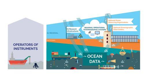
6 EMODnet network unlocks hidden and fragmentedmarine data resources Organisation 1 Org. 4 EMODnet Org. 3 Organisation 2


7 Unlocking data, bringing communities together and contributing to a better, data, coordinated observing system
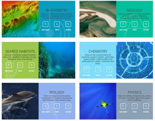
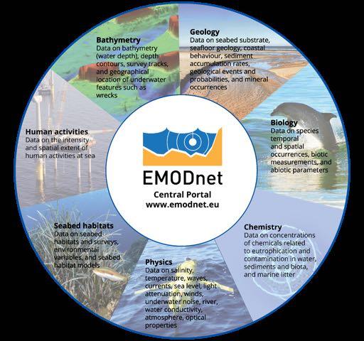
8 EMODnet gives access to a range of data archives across 7 themes

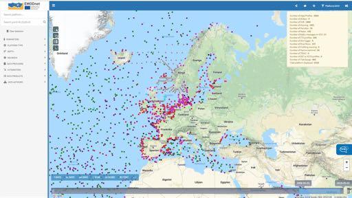
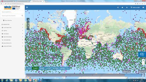
9 EMODnet Central Portal gives access to these data archives... 04/09/2018 9

10 through dedicated data portals 04/09/

11


12 Data Metadata Data Products Data Services


13 How much plastic waste has ended up in the sea since I started talking tons!

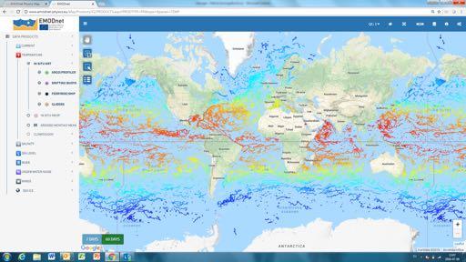
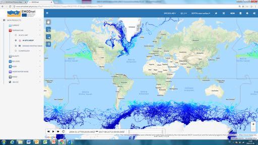
14
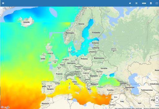
. In some cases information on water salinity, waves, and currents (EMODnet Physics) is also needed.")
15 When a pipeline needs to be installed, a very complex task is the pipeline route as it requires information on seabed topography (EMODnet Bathymetry and Geology), obstructions, debris, existing structures, other human activities, existing pipeline/ cable crossing (EMODnet Human Activities). In some cases information on water salinity, waves, and currents (EMODnet Physics) is also needed. EMODnet Human Activities recently created a dataset on offshore pipelines
16

17 EMODnet gives access to a range of data archives across 7 themes
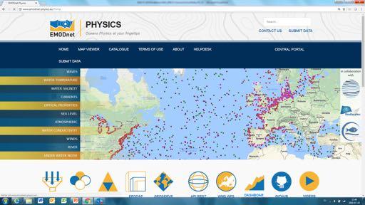
18
19

20

21
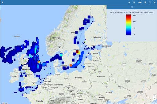
22 In a nutshell Data Near real-time (NRT) data at in situ observatories at sea Reprocessed NRT data Archived data derived from further elaboration and validation Temperature Salinity Waves Currents Sea Level Under water noise Parameters Wind Atmospheric param. Biogeochemical param. Optical properties Ice data River Runoff Products Data products Sea Level Temperature & Salinity Currents Ice coverage River runoff & TSM Impulsive Noise Services Data portal Catalogue Products portal Newsletter & digest Monitoring tools Reports (mail) http & permaurls API REST/SOAP OGC WMS, WFS, WCS THREDDS ERDDAP widgets

23
24
25


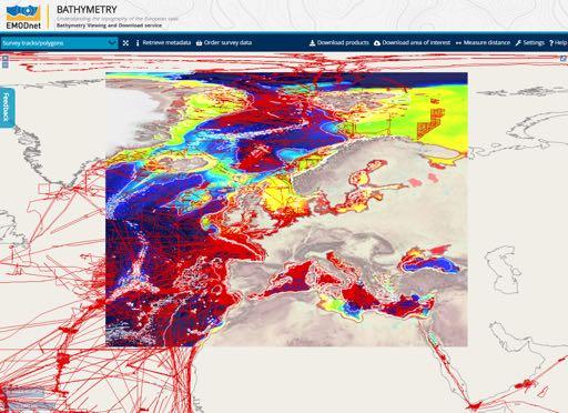
26


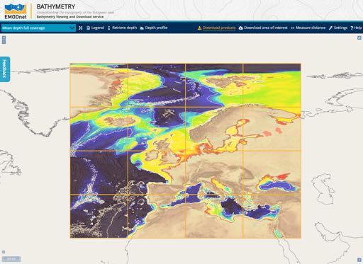
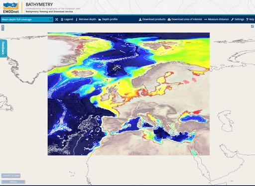
27 DATA PRODUCTS on physical parameters related to waves water temperature water salinity currents optical proporties sea level atmosphere water conductivity / biogeochemistry winds river runoff underwater noise

28 Products
29

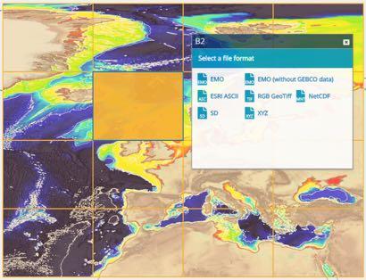
 and key ge")
30 Unlocking data and bringing communities together Southern Ocean Observing System, SOOSmap Explore spatial, temporal and multidisciplinary ocean observation data Overlaid on data products (e.g. SST, sea ice) and key geographic boundaries (e.g. CCAMLR) Discover circumpolar datasets Plot recent observations Download datasets
31 Data model A data model for implementation of HF radar data in European marine data infrastructures has been defined Quality Control QC standard methodology has been defined for the coordinated implementation of delayed-mode and near real time HF Radar data access Enhancement of Quality Control procedures for sensor based biochemical data Establishment of procedures or best practices for the Quality Control procedures that are applied on biochemical data recorded by sensors attached to the existing platforms, both in real-time and delayed-mode Integration of biological data In the framework of JERICO-NEXT an operational link has been created with EMODnet biology in order to facilitate the data exchange between existing marine biological data networks and data generated by the project.
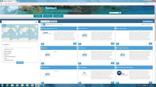
32
33 EMODnet gives access to a range of data archives across 7 themes
34 04/09/

35 DATA Bathymetric survey datasets
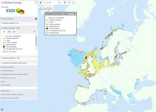
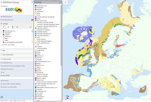
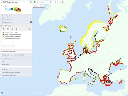
36 DATA Bathymetric survey datasets DATA PRODUCTS Digital Terrain Model (DTM) à European Sea regions à 1/8 x 1/8 arc minute
37 DATA PRODUCTS Digital Terrain Model (DTM) European sea regions 1/8 x 1/8 arc minute 04/09/
38
39 DATA Bathymetric survey datasets DATA PRODUCTS Digital Terrain Model (DTM) à European Sea regions à 1/8 x 1/8 arc minute Included: Depth contours Source references Survey tracks/polygons Coastal areas with high resolution bathymetry External products (GEBCO Undersea Features, Wrecks)
40
41


42 Sextant CATALOGUE Access to metadata: DTM Composite DTMs (= basis for EMODnet DTM)


43 WEB SERVICES Layers also available as OWS services
44 EMODnet gives access to a range of data archives across 7 themes
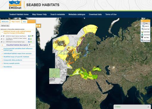
45 04/09/
46 MAPS showing information on Coastal behavior: coastal erosion, accretion or stability The location and type of geological events and probabilities (e.g. volcanoes, landslides, origin of tsunamis, ) The location of mineral occurrences The rates of sediment accumulation MAPS showing DATA PRODUCTS Seabed substrate Seafloor geology
47
48
49


50
51 WEB SERVICES All maps are also available as OWS services Product Catalogue Access to the metadata of all maps
52 EMODnet gives access to a range of data archives across 7 themes
53

54
55 MAPS showing a collection of Point data from surveys Datasets on OSPAR Habitats, and habitats in the Habitats Directive (Composite data products) MAPS showing DATA PRODUCTS (models) Individual habitat maps from surveys Modelled maps of specific habitats EUSeaMap (broad-scale habitat map EUNIS and MSFD classifications)
56
57

58
")
59 WEB SERVICES Allow user to access all layers through other applications (e.g. ArcGIS)
60 EMODnet gives access to a range of data archives across 7 themes
61 04/09/
62 DATA and DATA PRODUCTS on chemical substances related to Eutrophication Contamination Marine litter Acidity Radionuclides Antifoulants Silicates Chlorophyll Fertilisers Heavy metals Hydrocarbons Organic matter Dissolved gasses Pesticides and biocides Polychlorinated biphenyl
63 Oceanbrowser

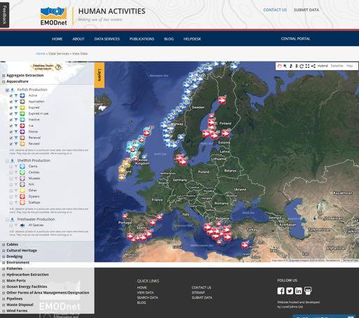
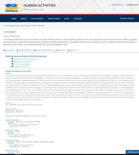
64 Sextant CATALOGUE Access to metadata of the Chemistry products WEB SERVICES Viewing and using data products in other software programs 64
65 EMODnet gives access to a range of data archives across 7 themes
66
67 DATA on Species occurrences of different functional groups: benthos, zooplankton, phytoplankton, fish, reptiles, marine mammals, algae, birds, angiosperms Biotic measurements of the species occurrences Abiotic parameters Information on sampling methodology
68

69 DATA on Species occurrences of different functional groups: benthos, zooplankton, phytoplankton, fish, reptiles, marine mammals, algae, birds, angiosperms Biotic measurements of the species occurrences Abiotic parameters Information on sampling methodology
70 DATA on Species occurrences of different functional groups: benthos, zooplankton, phytoplankton, fish, reptiles, marine mammals, algea, birds, angiosperms Biotic measurements of the species occurrences Abiotic parameters Information on sampling methodology DATA PRODUCTS on Species gridded abundance of different functional groups: benthos, zooplankton, phytoplankton, fish, reptiles, marine mammals, algae, birds, angiosperms ICES Operational Oceanographic Products and Services (OOPS) zooplankton abundance data (Copepods)
71


72 CATALOGUE Metadata of datasets WEB SERVICES
73 EMODnet gives access to a range of data archives across 7 themes

74

75 DATA on Aggregate extraction Aquaculture Cables Cultural heritage Dredging sites Environment Fisheries Hydrocarbon extraction Traffic in main ports Ocean energy facilities Other forms of area management/designation Pipelines Waste disposal Wind farms

76
77

78 WP4.3: Promotion activities
79

80


81 @EMODnet Your gateway to marine data in Europe
82 =p3vwngxyxuo
83 @EMODnet Your gateway to marine data in Europe
84 @EMODnet Your gateway to marine data in Europe
85 DATA PRODUCTS Digital Terrain Model (DTM) European sea regions 1/8 x 1/8 arc minute
 Depth")
86 DATA PRODUCTS Digital Terrain Model (DTM) Depth contours
87

88 Show them one by one
89
90
91
92
Data and data product catalogue. Preliminary version May 2018
 Data and data product catalogue Preliminary version May 2018 This document has been produced by the EMODnet Secretariat. All the maps have been extracted from the EMODnet thematic portals. Data Data products
EMODnet data. Flanders Marine Institute. Simon Claus. A. Giorgetti, D. Schaap, A. Novellino, A. Pititto, H.Lilis, V. Henry, T.
 EMODnet data Simon Claus A. Giorgetti, D. Schaap, A. Novellino, A. Pititto, H.Lilis, V. Henry, T. Schmitt Flanders Marine Institute EMODnet data themes Types of Data Vocabularies Data Exchange Format Metadata
The European Marine Observation and Data Network. EU-China Blue Year Event 1 June,
 The European Marine Observation and Data Network EU-China Blue Year Event 1 June, 2017 secretariat@emodnet.eu info@emodnet.eu There is only one Earth, with only one history, and we get only one chance
Introduction to EMODnet
 Introduction to EMODnet Antonio Novellino Torino, 14-15 Ottobre 2015 What is EMODnet? Initiated by the European Commission in response to the EU Future Maritime Policy and Blue Growth, launched in June
EMODnet High Resolution Seabed Mapping - further developing and providing a high resolution digital bathymetry for European seas
 EMODnet High Resolution Seabed Mapping - further developing and providing a high resolution digital bathymetry for European seas EGU Fall 2017 meeting New Orleans USA, December 2017 Schaap Dick MARIS,
EMODnet High Resolution Seabed Mapping - further developing a high resolution digital bathymetry for European seas
 EMODnet High Resolution Seabed Mapping - further developing a high resolution digital bathymetry for European seas IMDIS 2018 Conference, 7 November 2018, Barcelona - Spain Thierry Schmitt Dick M.A. Schaap
Bathymetry. EMODnet Stakeholder Conference & Sea-basin Workshops February Bathymetry
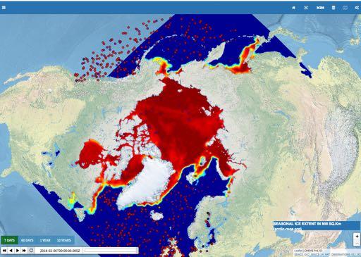
 EMODnet Stakeholder Conference & Sea-basin Workshops 14-15 February 2017 Arctic checkpoint Belinda Kater On behalf of all Checkpoints http://www.emodnet.eu 1 ? is the study of the "beds" or "floors" of
Monitoring the coastal ocean: from local to regional
 Monitoring the coastal ocean: from local to regional Luísa Bastos University of Porto / CIIMAR RAIA partners Ocean monitoring To answer key societal and scientific challenges navigation safety, fisheries,
BalticBOOST Appendix 1, WP 3.3 Deliverable 1 Final report 14 February 2017
 Theme 1: Biodiversity This is a deliverable from the BalticBOOST project that was coordinated by HELCOM and co-financed by the European Union in 2015-2016 as part of the programme DG ENV/MSFD Action Plans/2016.
Spatial Data Infrastructure for Marine Environnement Ifremer initiatives in France and in Europe
 E. Quimbert, M. Bellouis, F. Lecuy, M. Treguer Centre de Bretagne BP 70, Plouzané 29280 France E-mail: sextant@ifremer.fr Spatial Data Infrastructure for Marine Environnement Ifremer initiatives in France
European Commission STUDY ON INTERIM EVALUATION OF EUROPEAN MARINE OBSERVATION AND DATA NETWORK. Executive Summary
 European Commission STUDY ON INTERIM EVALUATION OF EUROPEAN MARINE OBSERVATION AND DATA NETWORK Executive Summary by NILOS Netherlands Institute for the Law of the Sea June 2011 Page ii Study on Interim
Physiography Ocean Provinces p. 1 Dimensions p. 1 Physiographic Provinces p. 2 Continental Margin Province p. 2 Deep-Ocean Basin Province p.
 Physiography Ocean Provinces p. 1 Dimensions p. 1 Physiographic Provinces p. 2 Continental Margin Province p. 2 Deep-Ocean Basin Province p. 2 Mid-Ocean Ridge Province p. 3 Benthic and Pelagic Provinces
GEBCO 2013 TSCOM. EMODNET Hydrography status report
 www.emodnet-hydrography.eu GEBCO 2013 TSCOM EMODNET Hydrography status report Eric Moussat, Ifremer on behalf of the Emodnet consortium 1 Background and objectives EU proposed to take steps in 2008 towards
The Danish Maritime Spatial Data Infrastructure (MSDI) Geodata of the Sea
 Geodata of the Sea") MSDI/MSP The Danish Maritime Spatial Data Infrastructure (MSDI) Geodata of the Sea Components of an infrastructure: DATA - metadata, datasets FUNCTIONALITY - spatial data services, web services and other
MSDI/MSP The Danish Maritime Spatial Data Infrastructure (MSDI) Geodata of the Sea Components of an infrastructure: DATA - metadata, datasets FUNCTIONALITY - spatial data services, web services and other
OCEANOGRAPHIC DATA MANAGEMENT
 OCEANOGRAPHIC DATA MANAGEMENT Presented to: Environmental Disaster Data Management Meeting Russ Beard Director, National Coastal Data Development Center Interim Science Coordinator, Gulf Restoration Council
2017 ESRI CANADA GIS SCHOLARSHIP REPORT CURRENT POLLUTION PROBLEMS IN THE OCEANS
 MAY 31, 2017 2017 ESRI CANADA GIS SCHOLARSHIP REPORT CURRENT POLLUTION PROBLEMS IN THE OCEANS HASSAAN RAFIQUE BACHELOR OF APPLIED TECHNOLOGY GEOGRAPHIC INFORMATION SYSTEMS SOUTHERN ALBERTA INSTITUTE OF
INSPIRE General Introduction & Service Architecture
 INSPIRATION Spatial Data Infrastructure in the Western Balkans INSPIRE General Introduction & Service Architecture 1st National INSPIRATION Workshop Croatia November 21-22, 2012 A multi-countryprojectfunded
MARINE SPATIAL PLANNING & MARINE CADASTRE: CHALLENGES AND ISSUES
 MARINE SPATIAL PLANNING & MARINE CADASTRE: CHALLENGES AND ISSUES Roger Longhorn Secretary General, GSDI Association rlonghorn@gsdi.org Member, IHO Marine SDI Working Group ral@alum.mit.edu Member, UNESCO
Geological information for Europe : Towards a pan-european Geological Data Infrastructure
 Geological information for Europe : Towards a pan-european Geological Data Infrastructure Integrating geoscientific information for EU competitiveness Co-funded by the European Union European societal
GEOSPATIAL DATA IN MARINE SDI SERVICES
 IMSC 2014 1 GEOSPATIAL DATA IN MARINE SDI SERVICES Duplančić Leder 1, Tea; Leder, Nenad 2, Tavra, Marina 1 ( 1 Faculty of Civil Engineering, Architecture and Geodesy, Matice hrvatske 15, 21000 Split, Croatia)
Black Sea Data Access services
 Black Sea Data Access services PERSEUS Oceanographic Mediterranean and Black Sea Data Management Cast Data Base with vertical profiles of physical, chemical and biological data acquired with Bottle casts
CopernicusEU. the EU's Earth Observation Programme. Sara Zennaro Atre Delegation of the European Union to Japan
 Copernicus the EU's Earth Observation Programme Sara Zennaro Atre Delegation of the European Union to Japan Status Overview, Sept 2016 & Ocean Policies Seminar 4 October 2016 ollow us on: Copernicus EU
SITMUN: Cooperating to Build Local SDIs in the Barcelona Region
 SITMUN: Cooperating to Build Local SDIs in the Barcelona Region Diputació de Barcelona Territory and Sustainability Area Territorial Information Systems Department INSPIRE CONFERENCE Barcelona, September
The known requirements for Arctic climate services
 The known requirements for Arctic climate services based on findings described in STT White paper 8/2015 Johanna Ekman / EC PHORS STT Regional drivers The Arctic region is home to almost four million people
Providing Marine Data. The German Marine Data Infrastructure (MDI-DE) as an example for best practice
 as an example for best practice") Providing Marine Data The German Marine Data Infrastructure (MDI-DE) as an example for best practice Data Originators 18 Agencies and Institutions in the EEZ and 12 Mile Zone Federal Government BSH Schleswig-Holstein
Providing Marine Data The German Marine Data Infrastructure (MDI-DE) as an example for best practice Data Originators 18 Agencies and Institutions in the EEZ and 12 Mile Zone Federal Government BSH Schleswig-Holstein
Specification & Content of Marine Reference Information
 Specification & Content of Marine Reference Information By Mike Osborne and James Rapaport SeaZone Solutions Limited CONTENTS 1. History of Marine Data 2. User Requirements 3. Geographic Content 4. SeaZone
Mapping of marine habitats in shallow coastal areas in Denmark
 6 th Workshop Seabed Acoustics, Rostock, November 14/15, 2013 P11-1 Mapping of marine habitats in shallow coastal areas in Denmark Dr. Zyad Al-Hamdani Geological Survey of Denmark and Greenland - GEUS
Mapping ecosystem services provided by benthic habitats in the European Atlantic Ocean
 Mapping and Assessment Ecosystem Services and Links to Good Environmental Status Mapping ecosystem services provided by benthic habitats in the European Atlantic Ocean Ibon Galparsoro, Angel Borja and
This report is largely based on input provided by the EMODnet thematic groups, inter alia from second year interim reports, supplemented by updates
 This report is largely based on input provided by the EMODnet thematic groups, inter alia from second year interim reports, supplemented by updates from the Secretariat. As the starting dates of the various
Updating the GEBCO Grid
 Updating the GEBCO Grid PAULINE WEATHERALL, GEBCO DIGITAL ATLAS MANAGER, BRITISH OCEANOGRAPHIC DATA CENTRE (BODC), NATIONAL OCEANOGRAPHY CENTRE (NOC), LIVERPOOL, UK. GEBCO TSCOM and SCRUM meeting, Kuala
Norwegian spatial data infrastructure supporting disaster risk management Norwegian Mapping Authority
 Norwegian spatial data infrastructure supporting disaster risk management Norwegian Mapping Authority Arvid Lillethun, Norwegian Mapping Authority Land and Poverty 2018 Conference, World Bank 19.-23. March
Geophysical Site Surveys
 Geophysical Site Surveys Simon Oakley Geoscience Team Leader Fugro Survey Limited 16/04/2014 Contents Menu Introduction Section 1 - Geophysical Site Surveys - Seabed Bathymetry - Shallow Geology - Seabed
Options in Capacity Building. Underpinning the Blue Economy. Slide 1/78. Derrick R. Peyton. 14 th MACHC Meeting. IIC Technologies. December 9-13, 2013
 Options in Capacity Building Underpinning the Blue Economy Derrick R. Peyton IIC Technologies 14 th MACHC Meeting December 9-13, 2013 Slide 1/78 Overview Blue Economy Defined Challenges (SDI, MSDI, Standards)
P r o d u c t p o r t f o l i o a n d d a t a a c c e s s
 P r o d u c t p o r t f o l i o a n d d a t a a c c e s s Copernicus Environment Service Copernicus EU Copernicus EU Copernicus EU www.copernicus.eu I N T R O D U C T I O N O F U S E C A S E User Uptake
European Space Agency
 Guidelines - Guidelines how/when to interact during the WebEx session: - Due to the number of attendees, please keep always your webcam and microphone switched-off - You can use anytime the chat to all
The Water Planet Ch. 22
 The Water Planet Ch. 22 What is Oceanography? the study of the Earth s oceans using chemistry, biology, geology, and physics. Oceans cover 70% of the Earth s surface Ocean Research 22.1 The use of submarines
Marine Base Maps in Coastal Norway: A Case for Developing Sustainable Blue Growth in Coastal Communities
 Marine Base Maps in Coastal Norway: A Case for Developing Sustainable Blue Growth in Coastal Communities Minika Ekanem Project Manager IMDIS 2018 The Norwegian Coastal Areas 422 municipalities in Norway
C o a s t a l p o l l u t i o n
 C o a s t a l p o l l u t i o n Copernicus for Coastal Zone Management and Marine Environment Monitoring Service Copernicus EU Copernicus EU Copernicus EU www.copernicus.eu I N T R O D U C T I O N Main
Introduction to Acoustic Remote Sensing and Seafloor Mapping (AE4-E13) May 19, 2010
 May 19, 2010") Introduction to Acoustic Remote Sensing and Seafloor Mapping (AE4-E13) May 19, 2010 1 Delft Vermelding Institute onderdeel of Earth organisatie Observation and Space Systems Why Acoustic Remote Sensing?
Introduction to Acoustic Remote Sensing and Seafloor Mapping (AE4-E13) May 19, 2010 1 Delft Vermelding Institute onderdeel of Earth organisatie Observation and Space Systems Why Acoustic Remote Sensing?
MESMA: An integrated tool box to support an ecosystem based spatial management of marine areas
 MESMA: An integrated tool box to support an ecosystem based spatial management of marine areas Stelzenmüller, V., Stamford, T., Vassilopoulou, V., Kastanevakis, S., Vincx, M, Vanaverbeke, J., Rabaut, M.,
HELSINKI COMMISSION Baltic Marine Environment Protection Commission
 HELSINKI COMMISSION Baltic Marine Environment Protection Commission HELCOM RECOMMENDATION 24/10 Adopted 25 June 2003, having regard to Article 20, Paragraph 1 b) of the 1992 Helsinki Convention IMPLEMENTATION
Marine SDI, INSPIRE and the EU. Marine Directives. Presenters:
 Marine SDI, INSPIRE and the EU Marine Directives Presenters: Roger Longhorn, Global Spatial Data Infrastructure (GSDI) Association and OGC Marine Domain Working Group Evangelia Balla, Permanent Committee
The Baltic Sea Region Maritime Spatial Planning Data Expert Sub-group. First Report 2015/2016/
 The Baltic Sea Region Maritime Spatial Planning Data Expert Sub-group First Report 2015/2016/2017 21.04.2017. Contents 1. Glossary 2 2. Introduction. 3 3. MSP Data. 5 3.1. Input Data. 5 3.2 Output Data.
Open Data meets Big Data
 Open Data meets Big Data Max Craglia, Sven Schade, Anders Friis European Commission Joint Research Centre www.jrc.ec.europa.eu Serving society Stimulating innovation Supporting legislation JRC is Technical
Current Hydrographic Projects at BSH
 7 th Workshop Seabed Acoustics, Rostock, November 19/20, 2015 P01-1 Current Hydrographic Projects at BSH Thomas Dehling Federal Maritime and Hydrographic Agency (BSH) Germany Contact Address Website BSH
INSPIRE Basics. Vlado Cetl European Commission Joint Research Centre. https://ec.europa.eu/jrc/
 INSPIRE Basics Vlado Cetl European Commission Joint Research Centre https://ec.europa.eu/jrc/ Serving society Stimulating innovation Supporting legislation Outline SDI? Why European SDI? INSPIRE Policy
The Australian Integrated Marine Observing System: Present and Future Possibilities
 The Australian Integrated Marine Observing System: Present and Future Possibilities Roger Proctor, IMOS/eMII emarine Information Infrastructure IMOS is supported by the Australian Government through the
INSPIRE Directive. Status June 2007
 INSPIRE Directive INfrastructure for SPatial InfoRmation in Europe Status June 2007 European Commission Directorate-General Environment Research, Science and Innovation Unit Rue de la Loi, 200 1049 Brussels
Intelligent Marine and Coastal Mapping Data
 O Intelligent Marine and Coastal Mapping Data When you need mapping data that is fit for purpose, in the right format, accurate and up to date Marine Themes Vector Marine Themes DEM Raster Charts XL Electronic
MERSEA Marine Environment and Security for the European Area
 MERSEA Marine Environment and Security for the European Area Development of a European system for operational monitoring and forecasting of the ocean physics, biogeochemistry, and ecosystems, on global
Interest for HOs to cooperate with EU Commission:
 Plenary session of the European IHO Network Working Group (IENWG) Interest for HOs to cooperate with EU Commission: Why HOs and the EU Commission need a closer cooperation Rear Admiral (N) Luigi SINAPI
Natura 2000 in the marine environment: state of implementation and next steps
 Life on the blue planet: biodiversity research and the new European marine policies EPBRS European Platform on Biodiversity Research Strategy Porto, Portugal 7-9 November 2007 Natura 2000 in the marine
Harmonisation of Spatial Planning Data
 INSPIRE Conference 18 June 2011 Edinburgh, Great Britain Harmonisation of Spatial Planning Data Tomas Mildorf University of West Bohemia mildorf@centrum.cz Pilsen, Czech Republic Co-funded by the Community
Maritime Spatial Planning Framework Directive Supported by INSPIRE
 Maritime Spatial Planning Framework Directive Supported by INSPIRE Andrej Abramić, Vanda Nunes de Lima, Paul Smits, Emanuele Bigagli, Chris Schubert European Commission Joint Research Centre Institute
GIS From Storing to Sharing. Esben Munk Sørensen
 GIS From Storing to Sharing Esben Munk Sørensen ems@land.aau.dk Aalborg University Department of Planning (www.plan.aau.dk) Innovative Fishery Management plus Geoinformation and Land Management = Blue
Economic and Social Council 10 July 2013
 ADVANCE UNEDITED VERSION UNITED NATIONS E/C.20/2013/10/Add.1 Economic and Social Council 10 July 2013 Committee of Experts on Global Geospatial Information Management Third session Cambridge, United Kingdom
The story of sharing environmental data
 The story of sharing environmental data Kallio, Pyhälahti, Harju, Teiniranta, Lahtinen, Finnish Environment Institute SYKE OKFestival, Finnish Open Data, 18. Sep 2012 Contents Call for environmental knowledge
Online availability of data of the Netherlands Hydrographic Service
 Online availability of data of the Netherlands Hydrographic Service In many cases, it is possible to obtain our data, through the form at www.hydro.nl. Go to Sales of nautical charts and publications and
Inspire Conference Istanbul, 2012 Ralf Lindgren. Inspire Conference Istanbul, 2012 Ralf Lindgren
 Background A Baltic Sea Bathymetry Database Concept and Hans Öiås Swedish Maritime Administration Hydrographic Office A national directive: The Swedish Maritime Administration shall, in cooperation with
Estonian approach to implementation of INSPIRE directive. Sulev Õitspuu Head of Bureau of Geoinfosystems Estonian Land Board
 Estonian approach to implementation of INSPIRE directive Sulev Õitspuu Head of Bureau of Geoinfosystems Estonian Land Board 13.06.2016 Contents - INSPIRE coordination in Estonia - INSPIRE implementation
Food for thoughts. Jon Davies MESH Project Coordinator
 Food for thoughts Jon Davies MESH Project Coordinator You are not alone.. There is someone out there.. Habmap UKSeaMap MESH Why is he here? Introduce the MESH Project, give a brief overview of other marine
Seabed knowledge In support of UN SDGs
 Seabed knowledge In support of UN SDGs Evert Flier Fiskerifaglig forum 2. november 2017 Hydrography & small scale fishing Hydrography in Transition Serving the Maritime Community Hydrography in Transition
New EU efforts to assess the state of the marine environment: the EMODnet Chemistry pilot project
 New EU efforts to assess the state of the marine environment: the EMODnet Chemistry pilot project Matteo Vinci and Alessandra Giorgetti, OGS NODC group, OCE September 2013 - IMDIS 2013, Lucca Overview
Implementation of the Political Declaration on energy cooperation between the North Seas Countries. Support Group 1 on Maritime Spatial Planning
 Implementation of the Political Declaration on energy cooperation between the North Seas Countries Support Group 1 on Maritime Spatial Planning Work Programme 1. Work area as outlined in Annex I to the
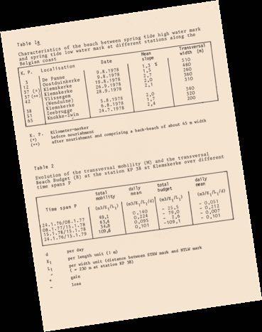
WP4: COASTAL PROCESSES
 WP4: COASTAL PROCESSES Coordinator: G. EBERHARDS Faculty of Geography and Earth Sciences, University of Latvia Daugavpils, 2008 Goal: The objective of this study is analysis of coastal changes and forecast
Crustose algae communities on Baltic infralittoral rock and mixed substrata
 European Red List of Habitats Marine: Baltic Habitat Group Crustose algae communities on Baltic infralittoral rock and mixed substrata Summary This benthic habitat is present throughout the Baltic where
Marine Spatial Management Tool
 Marine Spatial Management Tool Marine Spatial Management Tool Support the marine spatial planning process with updated and reliable geospatial information Marine management is important to Norway with
Applied Geoscience and Technology Division SOPAC. Joy Papao, Risk Information Systems Officer
 Joy Papao, Risk Information Systems Officer Secretariat of the Pacific Community SPC 22 Pacific Island States Head office in Noumea, New Caledonia 2 Regional offices (Pohnpei and Honiara) 600 staff 9 Technical
The Global Fundamental Geospatial Data Themes Journey. April Clare Hadley WG Chair
 The Global Fundamental Geospatial Data Themes Journey April 2018 Clare Hadley WG Chair The Road to here Why Global? Why Geospatial? Why Fundamental? Why Themes? The route we took Where does the road go
STAMP Spa)al Tools for Arc)c Mapping & Planning. Creating an interactive data tool to improve access and usability of Arctic data
al Tools for Arc)c Mapping & Planning. Creating an interactive data tool to improve access and usability of Arctic data") STAMP Spa)al Tools for Arc)c Mapping & Planning Creating an interactive data tool to improve access and usability of Arctic data Mission Provide easy access to physical, chemical, and biological data Network
STAMP Spa)al Tools for Arc)c Mapping & Planning Creating an interactive data tool to improve access and usability of Arctic data Mission Provide easy access to physical, chemical, and biological data Network
INSPIRE a backbone in spatially enabling the digital maritime society in the Baltic Sea region
 Lise Schrøder (AAU), Lena Hallin Pihlatie (SYKE) & Manuel Frias Vega (Helcom) INSPIRE a backbone in spatially enabling the digital maritime society in the Baltic Sea region Agenda The Baltic LINes project
Seabed 2030: A Call to Action
 Seabed 2030: A Call to Action Rear Adm. Shepard Smith NOAA Office of Coast Survey shep.smith@noaa.gov Introduction Many people like me start speeches about mapping the ocean with we know more about the
Marine/Maritime Spatial Planning Andrej Abramić
 Marine/Maritime Spatial Planning Andrej Abramić EcoAqua SUMMER SCHOOL: Ecosystem approach to aquaculture 26-29th of October 2015 Research and Technology to enhance excellence in Aquaculture development
The Arctic - A New Frontier The geological, environmental and engineering challenges for submarine telecommunication cables
 The Arctic - A New Frontier The geological, environmental and engineering challenges for submarine telecommunication cables Ryan Wopschall 5 September 2013 Oceanology International China, Shanghai Fugro
TABLE of content AN INTRODUCTION FROM THE HEAD OF THE EMODNET SECRETARIAT P.4 IS EUROPE S MARINE DATA INFRASTRUCTURE FIT FOR PURPOSE?
 TABLE of content AN INTRODUCTION FROM THE HEAD OF THE EMODNET SECRETARIAT P.4 1. ABOUT EMODNET P.6 2. 2017 IN PICTURES 4. 3. ENHANCING THE EMODNET OFFER: THE DATA INGESTION PORTAL AND THE NEW GEOVIEWER
Keywords: Wind resources assessment, Wind maps, Baltic Sea, GIS
 Advanced Materials Research Online: 2013-10-31 ISSN: 1662-8985, Vol. 827, pp 153-156 doi:10.4028/www.scientific.net/amr.827.153 2014 Trans Tech Publications, Switzerland Mapping of Offshore Wind Climate
Abstract. Introduction
 Southern California Aquaculture Site Assessment Model Caitlyn Raines University of Redlands Master of Science in Geographic Information Systems Program Abstract The Southern California Aquaculture Site
Detailed mapping of seabed topography,
 MAREANO program Detailed mapping of seabed topography, sediments, bottom fauna and pollutants in Norwegian waters HYDROGRAPHIC DATA FOR THE BENEFIT OF SOCIETY MAREANO program - Detailed mapping of seabed
a national geological survey perspective François ROBIDA BRGM (French Geological Survey)
") a national geological survey perspective François ROBIDA BRGM (French Geological Survey) Pre-Conference Seminar on Socio-Economic Value of Geospatial for National and Regional Development 21 August 2017,
a national geological survey perspective François ROBIDA BRGM (French Geological Survey) Pre-Conference Seminar on Socio-Economic Value of Geospatial for National and Regional Development 21 August 2017,
FEAST (Feature Activity Sensitivity Tool)
") FEAST (Feature Activity Sensitivity Tool) Dr Suz Henderson Coastal and Marine Ecosystems Unit (CMEU), SNH, Inverness. http://www.marine.scotland.gov.uk/feast/ FEAST sensitivity assessment FEAST enables
FEAST (Feature Activity Sensitivity Tool) Dr Suz Henderson Coastal and Marine Ecosystems Unit (CMEU), SNH, Inverness. http://www.marine.scotland.gov.uk/feast/ FEAST sensitivity assessment FEAST enables
BURGAS CASE STUDY: LAND-SEA INTERACTIONS. Dr. Margarita Stancheva
 BURGAS CASE STUDY: LAND-SEA INTERACTIONS Dr. Margarita Stancheva Name of presentation NEED FOR COHERENCE BETWEEN LAND AND SEA ACTIVITIES Name presenter Burgas is the fourth largest city in Bulgaria and
Marine Spatial Planning, a Norwegian user case NSHC33
 Marine Spatial Planning, a Norwegian user case NSHC33 Marine Spatial Management Tool Support the marine spatial planning process with updated and reliable geospatial information Marine management is important
Infrastructure for Spatial Information in Europe (INSPIRE)
") Infrastructure for Spatial Information in Europe (INSPIRE) 2011 GISCO Working Party 8-9.3.2012 INSPIRE is about improving access to spatial information: the environment doesn t stop at borders EU Geoportal
Infrastructure for Spatial Information in Europe (INSPIRE) 2011 GISCO Working Party 8-9.3.2012 INSPIRE is about improving access to spatial information: the environment doesn t stop at borders EU Geoportal
an accessible interface to marine environmental data Russell Moffitt
 an accessible interface to marine environmental data Russell Moffitt The Atlas Project GOAL: To provide a single point of access to oceanographic and environmental data for use by marine resource researchers,
Interoperability of Spatial Planning Data
 INSPIRE Conference 2010, Krakow, Poland Interoperability of Spatial Planning Data European Network of Best Practices for Interoperability of Spatial Planning Information Tomas Mildorf mildorf@centrum.cz
INSPIREd solutions for Air Quality problems Alexander Kotsev
 INSPIREd solutions for Air Quality problems Alexander Kotsev www.jrc.ec.europa.eu Serving society Stimulating innovation Supporting legislation The European data puzzle The European data puzzle 24 official
Tomas Mildorf, Karel Janecka University of West Bohemia in Pilsen Czech Republic
 European Network of Best Practices for Interoperability of Spatial Planning Information Tomas Mildorf, Karel Janecka mildorf@centrum.cz, kjanecka@kma.zcu.cz University of West Bohemia in Pilsen Czech Republic
Gulf of Finland Year 2014 An overview of activities and further visions
 Gulf of Finland Year 2014 An overview of activities and further visions The Gulf of Finland Maritime Assembly in Turku 6.-7.11.2014 Kai Myrberg Project Manager, Gulf of Finland Year 2014 Finnish Environment
INSPIRE. Data Specification for Meteorology. Bruce Wright, Expert Strategic Advisor (Data Management)
") INSPIRE Data Specification for Meteorology Bruce Wright, Expert Strategic Advisor (Data Management) Third Workshop on the use of GIS/OGC Standards in Meteorology- 15 November 2010 Table of Contents INSPIRE
INSPIRE Data Specification for Meteorology Bruce Wright, Expert Strategic Advisor (Data Management) Third Workshop on the use of GIS/OGC Standards in Meteorology- 15 November 2010 Table of Contents INSPIRE
Mapping of marine ecosystems and their services in the Bulgarian Black Sea region. Evaluation of current condition
 Mapping of marine ecosystems and their services in the Bulgarian Black Sea region. Evaluation of current condition V. Karamfilov, D. Berov, V. Biserkov, G. Daskalov, S. Klayn,Y. Biserkov- IBER-BAS V. Todorova,
An Arctic Perspective NCEI's Prototype Arctic Data Viewer
 An Arctic Perspective NCEI's Prototype Arctic Data Viewer NCEI Arctic Action Team Kate Rose NOAA National Environmental Satellite, Data, and Information Service National Centers for Environmental Information
EuroGeographics & INSPIRE. Nick Land, Executive Director of EuroGeographics
 EuroGeographics & INSPIRE Nick Land, Executive Director of EuroGeographics EuroGeographics A growing association 49 Members, 42 countries Topographic mapping, cadastre, land registry + Networked organisation
Marine Spatial Planning (MSP): A practical approach to ecosystembased
: A practical approach to ecosystembased") Marine Spatial Planning (MSP): A practical approach to ecosystembased management Erik Olsen, Institute of Marine Research, Norway Fanny Douvere, International Oceanographic Commission Overview Why we need
Marine Spatial Planning (MSP): A practical approach to ecosystembased management Erik Olsen, Institute of Marine Research, Norway Fanny Douvere, International Oceanographic Commission Overview Why we need
C o p e r n i c u s a n d W I G O S
 C o p e r n i c u s a n d W I G O S Jean-Noël Thépaut & Mark Dowell 24 October 2017 GEO XIV, Washington DC, 23-28 October 2017 T h e C o p e r n i c u s P r o g r a m m e Copernicus is the European Union
C M E M S O c e a n C o l o u r S a t e l l i t e P r o d u c t s
 Implemented by C M E M S O c e a n C o l o u r S a t e l l i t e P r o d u c t s This slideshow gives an overview of the CMEMS Ocean Colour Satellite Products Marine LEVEL1 For Beginners- Slides have been
BIOLOGICAL OCEANOGRAPHY
 BIOLOGICAL OCEANOGRAPHY AN INTRODUCTION 0 ^ J ty - y\ 2 S CAROL M. LALLI and TIMOTHY R. PARSONS University of British Columbia, Vancouver, Canada PERGAMON PRESS OXFORD NEW YORK SEOUL TOKYO ABOUT THIS VOLUME
IHO STAKEHOLDERS FORUM. Hydrographic data and its role in MSDI. Thursday 27 September Jens Peter Hartmann KMS
 IHO STAKEHOLDERS FORUM Hydrographic data and its role in MSDI Thursday 27 September Jens Peter Hartmann KMS Agenda Traditional approach to hydrographic data Expectations within the marine / maritime field
Collaborative Systems for the Creation of Marine Services
 Collaborative Systems for the Creation of Marine Services INSPIRE 2016 Nuno Almeida Nuno Catarino Barcelona, 28 th September 2016 Elecnor Deimos is a trademark which encompasses Elecnor Group companies
Relevant INSPIRE clusters/themes
 Relevant INSPIRE clusters/themes Marine and Atmosphere Cluster (III-13) Atmospheric conditions (AC) Ozone, composition (SO2, CH4, CO2), aerosols (III-14) Meteorological geographical features (MF) Temperature,
Capturing a Holistic Understanding of a Large Marine Ecosystem The NOAA Gulf of Mexico Data Atlas
 Capturing a Holistic Understanding of a Large Marine Ecosystem The NOAA Gulf of Mexico Data Atlas NODC / National Coastal Data Development Center gulfalas.noaa.gov Need: data that contribute to long-term