Updating the GEBCO Grid
|
|
|
- Magdalen Dayna Hancock
- 5 years ago
- Views:
Transcription
, LIVERPOOL, UK.")
1 Updating the GEBCO Grid PAULINE WEATHERALL, GEBCO DIGITAL ATLAS MANAGER, BRITISH OCEANOGRAPHIC DATA CENTRE (BODC), NATIONAL OCEANOGRAPHY CENTRE (NOC), LIVERPOOL, UK. GEBCO TSCOM and SCRUM meeting, Kuala Lumpur, Malaysia, October 2015

2 New version of the GEBCO grid released in December 2014 GEBCO_2014
3 GEBCO_2014 Grid Global terrain model at 30 arc-second intervals Update to previous grid, GEBCO_08, last published in 2010 Base grid is SRTM30_plus v5 Accompanied by a Source Identifier grid (SID) shows which grid cells are constrained by data/grids and those based on interpolation GEBCO_2014 includes new data from a number of regional mapping projects and from contributed data sets
4 GEBCO_2014 Grid New data sets contributed in the form of Pre-existing grids, e.g. IBCAO, EMODnet Soundings, e.g. ENC data sets Trackline data Methodology used to include data on top of the base grid largely depends on the data type Methods used to include pre-existing grids: mainly remove-restore procedure
5 GEBCO_2014 Grid new data sets International Bathymetric Chart of the Arctic Ocean (IBCAO) version 3 International Bathymetric Chart of the Southern Ocean (IBCSO) version 1 EMODNet Bathymetry grid 2013 release (NOAA), National Geophysical Data Center (NGDC), U.S North Atlantic Ocean, Gulf of Cadiz region: Bathymetric compilation produced under the European Science Foundation (ESF) Euromargins SWIM project Earthquake and Tsunami hazards of active faults at the South West Iberian Margin: deep structure, high-resolution imaging and paleoseismic signature Baltic Sea Bathymetry Data Base Waters around Australia: Australian Bathymetry and Topography Grid, June 2009 Bathymetry data for all ocean regions: From the Global Multi-Resolution Topography (GMRT) Data Synthesis, provided by the Lamont-Doherty Earth Observatory at Columbia University Japan Coast Guard Grid for the North Western Pacific Ocean region Indian Ocean, region off Sumatra: Bathymetric survey carried out by HMS Scott in 2005 Waters off the West Coast of Africa: update based on bathymetry data from Olex Northwest European Continental Shelf area: update based on bathymetry data from Olex South Pacific Ocean, Coral Sea region, update to correct an error in the GEBCO grid due to the inclusion of an erroneous island ( Sandy Island ) South China Sea region: update based on sounding data extracted from Electronic Navigation Charts (ENC), provided Waters off Chile, update based on ENC sounding data by the East Asia Hydrographic Commission North American Great Lakes: Bathymetric grids provided by the US National Oceanic and Atmospheric Administration
 are shown in white")
6 GEBCO_2014 Grid Coverage of GEBCO_2014 Source Identifier grid grid cells based on interpolation (where identified) are shown in white

7 GEBCO_2014 Grid Coverage of news data sets included in GEBCO_2014

8 GEBCO_2014 EMODnet grid

9 GEBCO_2014 GEBCO_08 grid
10 GEBCO_2014 GEBCO_2014

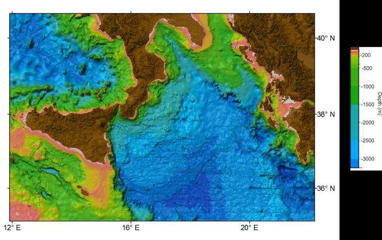
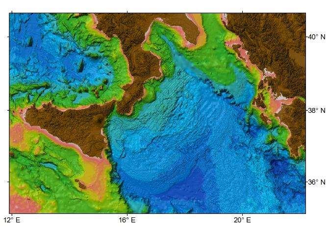
11 GEBCO_2014 Grid Example comparison between previous grid GEBCO_08 and GEBCO_2014 Further comparison imagery and data set documentation available on GEBCO s web site: n_ /

12 Making GEBCO s grids available GEBCO s gridded data sets are available to download from:
13 Making GEBCO s grids available Data accessible for user-defined areas or global grid files Export formats: One dimensional (1D) netcdf grid (aimed for use with GDA) CF compliant netcdf (2D) Esri ASCII raster Data GeoTiff
14 Other GEBCO-related work at BODC Development of a contour data set for the GEBCO_2014 Grid Web Map Service (WMS) update work WMS development work for delivering metadata for the SID grid Statistics on data downloads and access to GEBCO s web site included in: gebco_report_october_2015.pdf
15 Thank you
The route towards a new GEBCO grid
 The route towards a new GEBCO grid Pauline Weatherall, GEBCO Digital Atlas Manager British Oceanographic Data Centre (BODC) GEBCO TSCOM/SCRUM meeting, Monaco, October 2012 The route towards a new GEBCO
Updating the GEBCO_08 Grid with regional compilations and surveys
 Updating the GEBCO_08 Grid with regional compilations and surveys Pauline Weatherall, GEBCO Digital Atlas Manager, British Oceanographic Data Centre (BODC) GEBCO TSCOM/iSCRUM meeting, SIO, October 2011
Briefing on the work of GEBCO (GENERAL BATHYMETRIC CHART OF THE OCEANS)
") Briefing on the work of GEBCO (GENERAL BATHYMETRIC CHART OF THE OCEANS) 7th ROPME Sea Area Hydrographic Commission Meeting, Muscat, Oman 20-22 February 2017 What is GEBCO? The General Bathymetric Chart
Briefing on the work of GEBCO (GENERAL BATHYMETRIC CHART OF THE OCEANS) 7th ROPME Sea Area Hydrographic Commission Meeting, Muscat, Oman 20-22 February 2017 What is GEBCO? The General Bathymetric Chart
Established Global bathymetry yproducts. Undersea feature names. Capacity building
 IHO IOC Established 1903 Global bathymetry yproducts Undersea feature names Capacity building A GEBCO data GEBCO s d t sets t and d products d t Global bathymetric grids Global set of bathymetric contours
GEBCO 2013 TSCOM. EMODNET Hydrography status report
 www.emodnet-hydrography.eu GEBCO 2013 TSCOM EMODNET Hydrography status report Eric Moussat, Ifremer on behalf of the Emodnet consortium 1 Background and objectives EU proposed to take steps in 2008 towards
General Bathymetric Chart of the Oceans
 General Bathymetric Chart of the Oceans GEBCO A look at the world from an ocean s perspective On behalf of GEBCO: Boris Dorschel 1, Martin Jakobsson 2 1 Department of Geophysics, Alfred Wegener Institute
Into the Digital Age the GEBCO Digital Atlas
 1983-2003 1983 * Digitisation of the GEBCO Fifth Edition - 1993 1993 * Initialisation of the GEBCO Digital Atlas 1993 * Updating the GEBCO Digital Atlas - 2003 Revised Bathymetry - contours Creation of
User Guide to the GEBCO Digital Atlas and its data sets
 User Guide to the GEBCO Digital Atlas and its data sets Editor: Meirion T Jones, Former Chairman, GEBCO Sub-Committee on Digital Bathymetry GDA Manager: Pauline Weatherall, BODC GDA Software: Raymond N
Digital Elevation Model of Tutuila, American Samoa: Procedures, Data Sources, and Analysis
 Digital Elevation Model of Tutuila, American Samoa: Procedures, Data Sources, and Analysis Prepared for the National Tsunami Hazard Mitigation Program (NTHMP) by the NOAA National Geophysical Data Center
IHO Perspective on a Marine Spatial Data Infrastructure
 IHO Perspective on a Marine Spatial Data Infrastructure Anthony Pharaoh (International Hydrographic Bureau) Definitions of Hydrography on the Web: The study of the surface waters of the Earth. www.geographic.org/glossary.html
groups.
 http://www.gebco.net GEBCO's aim is to provide the most authoritative publicly-available bathymetry of the world's oceans. It operates under the joint auspices of the Intergovernmental Oceanographic Commission
SCAR Expert Group on IBCSO Report to GSSG
 SCAR Expert Group on IBCSO Report to GSSG Hans Werner Schenke, AWI Norbert Ott, AWI 12/16/2008 IBCSO Report to HCA-8 Niterói, 1 Content 1. Retrospect 2. Framework 3. Objectives 4. Report on IBCSO Progress
Geographic Information Systems Tools for Collecting and Accessing Arctic Bathymetry: International Bathymetric Chart of the Arctic Ocean
 University of New Hampshire University of New Hampshire Scholars' Repository Center for Coastal and Ocean Mapping Center for Coastal and Ocean Mapping 1-22-2001 Geographic Information Systems Tools for
EMODnet High Resolution Seabed Mapping - further developing and providing a high resolution digital bathymetry for European seas
 EMODnet High Resolution Seabed Mapping - further developing and providing a high resolution digital bathymetry for European seas EGU Fall 2017 meeting New Orleans USA, December 2017 Schaap Dick MARIS,
Image Services Providing Access to Scientific Data at NOAA/NCEI
 Image Services Providing Access to Scientific Data at NOAA/NCEI Jesse Varner Cooperative Institute for Research in Environmental Sciences (CIRES), University of Colorado John Cartwright NOAA National Centers
Bathymetry. EMODnet Stakeholder Conference & Sea-basin Workshops February Bathymetry
 EMODnet Stakeholder Conference & Sea-basin Workshops 14-15 February 2017 Arctic checkpoint Belinda Kater On behalf of all Checkpoints http://www.emodnet.eu 1 ? is the study of the "beds" or "floors" of
EMODnet High Resolution Seabed Mapping - further developing a high resolution digital bathymetry for European seas
 EMODnet High Resolution Seabed Mapping - further developing a high resolution digital bathymetry for European seas IMDIS 2018 Conference, 7 November 2018, Barcelona - Spain Thierry Schmitt Dick M.A. Schaap
IHO Input to the Report of the UN Secretary General on Oceans and Law of the Sea Executive Summary General
 IHO Input to the Report of the UN Secretary General on Oceans and Law of the Sea The following notes provide information on activities of the International Hydrographic Organization that are relevant to
MARINE GEOLOGY & GEOGRAPHY
 MARINE GEOLOGY & GEOGRAPHY Bathymetry BATHYMETRY BATHYMETRY THE UNDERWATER EQUIVALENT TO TOPOGRAPHY THE STUDY OF WATER DEPTH A BATHYMETRIC MAP SHOWS FLOOR RELIEF OR TERRAIN AS CONTOUR LINES Bathymetry
General Bathymetric Chart of the Oceans (GEBCO) The GEBCO_08 Grid
 The GEBCO_08 Grid") General Bathymetric Chart of the Oceans (GEBCO) The GEBCO_08 Grid Content i. Preface 1. Introduction - The GEBCO_08 Grid 2. Data set update history 3. Grid contents 3.1 Bathymetry data 3.2 Land data 4.
General Bathymetric Chart of the Oceans (GEBCO) The GEBCO_08 Grid Content i. Preface 1. Introduction - The GEBCO_08 Grid 2. Data set update history 3. Grid contents 3.1 Bathymetry data 3.2 Land data 4.
Proposal for the preparation of a new International Bathymetric Chart of the Southern Ocean (IBCSO) to be presented at the 3 rd HCA Meeting
 to be presented at the 3 rd HCA Meeting") IHO HYDROGRAPHIC COMMITTEE ON ANTARCTICA (HCA) 3rd Meeting, IHB, Monaco, 8-10 September 2003 Dr.-Ing. Hans Werner Schenke Proposal for the preparation of a new International Bathymetric Chart of the Southern
IHO HYDROGRAPHIC COMMITTEE ON ANTARCTICA (HCA) 3rd Meeting, IHB, Monaco, 8-10 September 2003 Dr.-Ing. Hans Werner Schenke Proposal for the preparation of a new International Bathymetric Chart of the Southern
Bathymetry Data and Models: Best Practices
 Bathymetry Data and Models: Best Practices Barry Eakins & Lisa Taylor The NOAA National Geophysical Data Center Over 600 data types - from the core of the Earth to the surface of the Sun NGDC Bathymetry
09 November 2017 (Week ) NEW BRITISH ADMIRALTY PUBLICATIONS AVAILABLE NOW
 NEW BRITISH ADMIRALTY PUBLICATIONS AVAILABLE NOW") 09 November 2017 (Week 45 2017) NEW BRITISH ADMIRALTY PUBLICATIONS AVAILABLE NOW CODE TITLE AVAILABLE PRICE GBP NP057B Norway Pilot Volume 2B, 10th Edition, 2017 WK 45/17 60.60 NP207-18 ADMIRALTY Tide
09 November 2017 (Week 45 2017) NEW BRITISH ADMIRALTY PUBLICATIONS AVAILABLE NOW CODE TITLE AVAILABLE PRICE GBP NP057B Norway Pilot Volume 2B, 10th Edition, 2017 WK 45/17 60.60 NP207-18 ADMIRALTY Tide
Initiatives in Using Crowdsourcing, Satellite Derived Bathymetry, and Other Non-Traditional Hydrographic/Bathymetric Measurements
 University of New Hampshire University of New Hampshire Scholars' Repository Center for Coastal and Ocean Mapping Center for Coastal and Ocean Mapping 10-5-2015 Initiatives in Using Crowdsourcing, Satellite
Billions of measurements for millions of square kilometres
 Billions of measurements for millions of square kilometres Dr. Mathias Jonas Secretary-General of the : History and Constitution 2 1 All waters on earth 3 20 th Century idea: GEBCO General bathymetric
1. Name at least one place that the mid-atlantic Ridge is exposed above sea level.
 Interpreting Tectonic and Bathymetric Maps. The purpose of this lab is to provide experience interpreting the bathymetry of the seafloor in terms of tectonic and geologic settings and processes. Use the
Integrated Hydrodynamic Modeling System
 Integrated Hydrodynamic Modeling System Applied Science Associates, Inc. 70 Dean Knauss Drive Narragansett, RI USA 02882 www.asascience.com support@asascience.com 1 Introduction HYDROMAP is a globally
Figure 3.1: Illustration showing the bathymetry s role for the tsunami propagation following the earth quake 26 December 2004 outside of Sumatra.
 Figure 3.1: Illustration showing the bathymetry s role for the tsunami propagation following the earth quake 26 December 2004 outside of Sumatra. The left globe shows the seafloor bathymetry as portrayed
Specification & Content of Marine Reference Information
 Specification & Content of Marine Reference Information By Mike Osborne and James Rapaport SeaZone Solutions Limited CONTENTS 1. History of Marine Data 2. User Requirements 3. Geographic Content 4. SeaZone
Compilation and validation of bathymetric data for the South China Sea with an emphasis on shallow region
 九州大学大学院総合理工学府報告 Engineering Sciences Reports, Kyushu University 第 35 巻第 2 号 7-13 頁平成 26 年 2 月 Vol. 35, No. 2, pp. 7-13, FEB, 2014 Compilation and validation of bathymetric data for the South China Sea
MARINE GEOLOGY & GEOGRAPHY
 MARINE GEOLOGY MARINE GEOLOGY & GEOGRAPHY Marine Geology 4 LAYERS OF THE EARTH CRUST THICKNESS: VARIES BETWEEN OCEAN & CONTINENTS 5-40 KM STATE: SOLID ELEMENTS: SILICON, ALUMINUM, CALCIUM, SODIUM, POTASSIUM
Numerical Simulation of Hydrodynamic for Abrupt Bathymetry in Palu River Estuary
 Indian Journal of Science and Technology, Vol 10(29), DOI: 10.17485/ijst/2017/v10i29/116502, August 2017 ISSN (Print) : 0974-6846 ISSN (Online) : 0974-5645 Numerical Simulation of Hydrodynamic for Abrupt
Effect of the Emperor seamounts on trans-oceanic propagation of the 2006 Kuril Island earthquake tsunami
 GEOPHYSICAL RESEARCH LETTERS, VOL. 35, L02611, doi:10.1029/2007gl032129, 2008 Effect of the Emperor seamounts on trans-oceanic propagation of the 2006 Kuril Island earthquake tsunami S. Koshimura, 1 Y.
OCEANOGRAPHY MEASURING THE DEPTHS OF THE OCEANS
 Water 2 page 1 OCEANOGRAPHY Name If all the water was drained from the ocean basins, what kind of surface would be revealed? It would not be the quiet, subdued topography as was once thought, but a surface
Chapter 02 The Sea Floor
 Chapter 02 The Sea Floor Multiple Choice Questions 1. One of the following is not one of the world's major ocean basins: A. Atlantic Ocean B. Arctic Ocean C. Indian Ocean D. Antarctic Ocean E. Pacific
Climate Outlook for December 2015 May 2016
 The APEC CLIMATE CENTER Climate Outlook for December 2015 May 2016 BUSAN, 25 November 2015 Synthesis of the latest model forecasts for December 2015 to May 2016 (DJFMAM) at the APEC Climate Center (APCC),
WERA Ocean Radar Capability of Real-Time Tsunami Detection
 WERA Ocean Radar Capability of Real-Time Tsunami Detection Dr. Anna Dzvonkovskaya Helzel Messtechnik GmbH Kaltenkirchen, GERMANY e-mail: dzvonkovskaya@helzel.com member of and Worldwide WERA HF Ocean Radar
Figure 3.1: Illustration showing the bathymetry s role for the tsunami propagation following the earth quake 26 December 2004 outside of Sumatra.
 Figure 3.1: Illustration showing the bathymetry s role for the tsunami propagation following the earth quake 26 December 2004 outside of Sumatra. The left globe shows the seafloor bathymetry as portrayed
Indian Ocean Tsunami Warning System: Example from the 12 th September 2007 Tsunami
 Indian Ocean Tsunami Warning System: Example from the 12 th September 2007 Tsunami Charitha Pattiaratchi 1 Professor of Coastal Oceanography, The University of Western Australia Email: chari.pattiaratchi@uwa.edu.au
Bathymetric Attributed Grids (BAGs): Discovery of Marine Datasets and Geospatial Metadata Visualization
: Discovery of Marine Datasets and Geospatial Metadata Visualization") University of New Hampshire University of New Hampshire Scholars' Repository Center for Coastal and Ocean Mapping Center for Coastal and Ocean Mapping 2010 Bathymetric Attributed Grids (BAGs): Discovery
University of New Hampshire University of New Hampshire Scholars' Repository Center for Coastal and Ocean Mapping Center for Coastal and Ocean Mapping 2010 Bathymetric Attributed Grids (BAGs): Discovery
Forecast of Nearshore Wave Parameters Using MIKE-21 Spectral Wave Model
 Forecast of Nearshore Wave Parameters Using MIKE-21 Spectral Wave Model Felix Jose 1 and Gregory W. Stone 2 1 Coastal Studies Institute, Louisiana State University, Baton Rouge, LA 70803 2 Coastal Studies
Appendix E: Oceanographic Databases
 Appendix E: Oceanographic Databases Many of the principal U.S. and international database depositories for worldwide ocean observations are listed below, as are a few technical reports with descriptions
Modeling Storm Surge for Emergency Management
 Modeling Storm Surge for Emergency Management Study Area: Guam is the southern-most island of the Mariana Archipelago and is located at 13 28 N, 144 47 E. It has a total area of 541.3 sq. km. and the highest
JNES open code for Tsunami Hazard Assessments at NPP site supplied in IAEA/Tsunami EBP
 ANSN Regional Workshop on Site Selection and Evaluation for Nuclear Power Plants June 2010, Hanoi Vietnam IAEA/ISSC JNES open code for Tsunami Hazard Assessments at NPP site supplied in IAEA/Tsunami EBP
Source of the July 2006 West Java tsunami estimated from tide gauge records
 GEOPHYSICAL RESEARCH LETTERS, VOL. 33, L24317, doi:10.1029/2006gl028049, 2006 Source of the July 2006 West Java tsunami estimated from tide gauge records Yushiro Fujii 1 and Kenji Satake 2 Received 13
Climate Outlook for March August 2018
 The APEC CLIMATE CENTER Climate Outlook for March August 2018 BUSAN, 26 February 2018 The synthesis of the latest model forecasts for March to August 2018 (MAMJJA) from the APEC Climate Center (APCC),
DATA BASE DEVELOPMENT OF ETA (ESTIMATED TIME OF ARRIVAL) FOR TSUNAMI DISASTER MITIGATION AT SOUTHWESTERN CITIES OF ACEH, INDONESIA
 FOR TSUNAMI DISASTER MITIGATION AT SOUTHWESTERN CITIES OF ACEH, INDONESIA") 6 th South China Sea Tsunami Workshop Nanyang Technology University, Singapore, 6-8 November 2013 DATA BASE DEVELOPMENT OF ETA (ESTIMATED TIME OF ARRIVAL) FOR TSUNAMI DISASTER MITIGATION AT SOUTHWESTERN
6 th South China Sea Tsunami Workshop Nanyang Technology University, Singapore, 6-8 November 2013 DATA BASE DEVELOPMENT OF ETA (ESTIMATED TIME OF ARRIVAL) FOR TSUNAMI DISASTER MITIGATION AT SOUTHWESTERN
INTERNATIONAL JOURNAL OF GEOMATICS AND GEOSCIENCES Volume 1, No 4, 2011
 Detection of seafloor channels using Bathymetry data in Geographical Information Systems Kundu.S.N, Pattnaik.D.S Department of Geology, Utkal University, Vanivihar, Bhubaneswar. Orissa. snkundu@gmail.com
v=7tat9croynk&feature=youtu.be
 https://www.youtube.com/watch? v=7tat9croynk&feature=youtu.be Malta Summer School 2018 Operational Oceanography for Blue Growth EMODnet in a nutshell: unlocking, and offering access to, European marine
Climate Outlook for October 2017 March 2018
 The APEC CLIMATE CENTER Climate Outlook for October 2017 March 2018 BUSAN, 25 September 2017 The synthesis of the latest model forecasts for October 2017 to March 2018 (ONDJFM) from the APEC Climate Center
Digital Elevation Model (DEM) of Sable Island Bank and adjacent areas
 of Sable Island Bank and adjacent areas") GEOLOGICAL SURVEY OF CANADA OPEN FILE 5348 Digital Elevation Model (DEM) of Sable Island Bank and adjacent areas K.J. Webb and E.L. King 2014 GEOLOGICAL SURVEY OF CANADA OPEN FILE 5348 Digital Elevation
GEOLOGICAL SURVEY OF CANADA OPEN FILE 5348 Digital Elevation Model (DEM) of Sable Island Bank and adjacent areas K.J. Webb and E.L. King 2014 GEOLOGICAL SURVEY OF CANADA OPEN FILE 5348 Digital Elevation
ATOC 5051 INTRODUCTION TO PHYSICAL OCEANOGRAPHY. Lecture 2
 ATOC 5051 INTRODUCTION TO PHYSICAL OCEANOGRAPHY Lecture 2 Ocean basins and relation to climate Learning objectives: (1)What are the similarities and differences among different ocean basins? (2) How does
Small area of the ocean that is partially surrounded by land. The Ocean Basins. Three Major Oceans. Three Major Oceans. What is a SEA?
 The Ocean Basins How Deep is the Ocean? 1 2 Three Major Oceans Three Major Oceans Pacific Atlantic the shallowest ocean (3.3km average depth) Indian second shallowest ocean (3.8km average depth) Pacific
VALIDATION OF TSUNAMI INUNDATION MODELING FOR THE 2004 SUMATRA-ANDAMAN EARTHQUAKE FOR MAKING HAZARD MAPS IN PENANG AND LANGKAWI, MALAYSIA
 Synopses of Master Papers Bulletin of IISEE, 47, 11-16, 013 VALIDATION OF TSUNAMI INUNDATION MODELING FOR THE 004 SUMATRA-ANDAMAN EARTHQUAKE FOR MAKING HAZARD MAPS IN PENANG AND LANGKAWI, MALAYSIA Noor
IODP drilling and core storage facilities
 4 IODP drilling and core storage facilities Neville Exon As the knowledge obtainable from ocean drilling is various and extensive, its end-users are similarly various and extensive. Scientific ocean drilling
Chapter Overview. Bathymetry. Measuring Bathymetry. Measuring Bathymetry
 CHAPTER 3 Marine Provinces Chapter Overview The study of bathymetry determines ocean depths and ocean floor topography. Echo sounding and satellites are efficient bathymetric tools. Most ocean floor features
Meeting July 2018 Agenda Item 7.1. Tsunami Service Provider Messages for the Maritime Community. Submitted by IOC Secretariat SUMMARY
 WWNWS WWNWS10/7/1 Meeting 10 19 July 2018 Agenda Item 7.1 Tsunami Service Provider Messages for the Maritime Community Submitted by IOC Secretariat SUMMARY Executive Summary: This document provides details
NEW TOOLS TO IMPROVE DESKTOP SURVEYS
 NEW TOOLS TO IMPROVE DESKTOP SURVEYS Pablo Vengoechea (Telemediciones S.A.), Jorge O. García (Telemediciones S.A.), Email: Telemediciones S.A. / Cra. 46 94-17 Bogotá D.C.
Supplement of Scenario-based numerical modelling and the palaeo-historic record of tsunamis in Wallis and Futuna, Southwest Pacific
 Supplement of Nat. Hazards Earth Syst. Sci., 15, 1763 1784, 2015 http://www.nat-hazards-earth-syst-sci.net/15/1763/2015/ doi:10.5194/nhess-15-1763-2015-supplement Author(s) 2015. CC Attribution 3.0 License.
The Bathymetry of the Central Mediterranean Sea in the framework of the EMODnet project a case study of bathymetric data integration and processing.
 The Bathymetry of the Central Mediterranean Sea in the framework of the EMODnet project a case study of bathymetric data integration and processing. Federica Foglini & Marzia Rovere CNR-ISMAR Institute
Map shows 3 main features of ocean floor
 Map shows 3 main features of ocean floor 2017 Pearson Education, Inc. Chapter 3 Marine Provinces 2017 Pearson Education, Inc. 1 Chapter 3 Overview The study of bathymetry determines ocean depths and ocean
1. Draw a line from each ocean listed below to its location on the map. 2. Label the Pacific Ring of Fire on the map above.
 1. Draw a line from each ocean listed below to its location on the map. Atlantic Ocean Pacific Ocean Indian Ocean Arctic Ocean 2. Label the Pacific Ring of Fire on the map above. 3. Find Fairbanks on the
New EU efforts to assess the state of the marine environment: the EMODnet Chemistry pilot project
 New EU efforts to assess the state of the marine environment: the EMODnet Chemistry pilot project Matteo Vinci and Alessandra Giorgetti, OGS NODC group, OCE September 2013 - IMDIS 2013, Lucca Overview
NUMERICAL SIMULATIONS FOR TSUNAMI FORECASTING AT PADANG CITY USING OFFSHORE TSUNAMI SENSORS
 NUMERICAL SIMULATIONS FOR TSUNAMI FORECASTING AT PADANG CITY USING OFFSHORE TSUNAMI SENSORS Setyoajie Prayoedhie Supervisor: Yushiro FUJII MEE10518 Bunichiro SHIBAZAKI ABSTRACT We conducted numerical simulations
Originally published as:
 Originally published as: Henstock, T., McNeill, L., Dean, S., Barton, P., Tilmann, F., Rietbrock, A., Robinson, D., Gulick, S., Austin, J., Djajadihardja, Y., Natawidjaja, D., Permana, H., Bonneville,
BOWDITCH PLUS! The Complete Navigator s Library Table of Contents
 STARPATH BOWDITCH PLUS! The Complete Navigator s Library Table of Contents The American Practical Navigator (Bowditch 2002) The US encyclopedia of navigation, some 1000 pages covers all aspects of navigation,
Applications of GIS and Remote Sensing in Ocean Exploration
 Applications of GIS and Remote Sensing in Ocean Exploration Geographic Information Systems (GIS) and Remote Sensing (RS) are critical to the success of Ocean Exploration. In the most basic sense, there
Climate Outlook for March August 2017
 The APEC CLIMATE CENTER Climate Outlook for March August 2017 BUSAN, 24 February 2017 Synthesis of the latest model forecasts for March to August 2017 (MAMJJA) at the APEC Climate Center (APCC), located
Upgrades to the Operational Sea State Forecast System
 NMOC Operations Bulletin No. 53 Upgrades to the Operational Sea State Forecast System Introduction 25 August 2000 The WAM wave model (WAMDI, 1988, Komen et al., 1994) has been the operational sea state
Bathymetry Measures the vertical distance from the ocean surface to mountains, valleys, plains, and other sea floor features
 1 2 3 4 5 6 7 8 9 10 11 CHAPTER 3 Marine Provinces Chapter Overview The study of bathymetry determines ocean depths and ocean floor topography. Echo sounding and satellites are efficient bathymetric tools.
IHO HYDROGRAPHIC COMMISION ON ANTARCTICA (HCA) 9 th Meeting, Simon's Town, Cape Town, South Africa, October 2009
 9 th Meeting, Simon's Town, Cape Town, South Africa, October 2009") HCA9-07.4Ac IHO HYDROGRAPHIC COMMISION ON ANTARCTICA (HCA) 9 th Meeting, Simon's Town, Cape Town, South Africa, 12-14 October 2009 National Report - JAPAN Hydrographic and Oceanographic Department of Japan
HCA9-07.4Ac IHO HYDROGRAPHIC COMMISION ON ANTARCTICA (HCA) 9 th Meeting, Simon's Town, Cape Town, South Africa, 12-14 October 2009 National Report - JAPAN Hydrographic and Oceanographic Department of Japan
UNDERSEA FEATURE NAME PROPOSAL (Sea NOTE overleaf)
") INTERNATIONAL HYDROGRAPHIC ORGANIZATION INTERGOVERNMENTAL OCEANOGRAPHIC COMMISSION (of UNESCO) UNDERSEA FEATURE NAME PROPOSAL (Sea NOTE overleaf) Note: The boxes will expand as you fill the form. Name
INTERNATIONAL HYDROGRAPHIC ORGANIZATION INTERGOVERNMENTAL OCEANOGRAPHIC COMMISSION (of UNESCO) UNDERSEA FEATURE NAME PROPOSAL (Sea NOTE overleaf) Note: The boxes will expand as you fill the form. Name
INTO THE DIGITAL AGE THE GEBCO DIGITAL ATLAS
 Charting the Secret World of the Ocean Floor. The GEBCO Project 1903-2003 1 INTO THE DIGITAL AGE THE GEBCO DIGITAL ATLAS By Dr. Meirion T. Jones Dr Jones was the Founding Director of the British Oceanographic
National / Naval Ice Center (NIC) Operations Brief This brief is UNCLASSIFIED
 Operations Brief This brief is UNCLASSIFIED") National / Naval Ice Center (NIC) Operations Brief This brief is UNCLASSIFIED Christopher Szorc, Senior Ice Analyst/Forecaster USCG USN NOAA Outline NIC s mission is to provide timely, accurate and relevant
National / Naval Ice Center (NIC) Operations Brief This brief is UNCLASSIFIED Christopher Szorc, Senior Ice Analyst/Forecaster USCG USN NOAA Outline NIC s mission is to provide timely, accurate and relevant
The Bottom of the Ocean
 The Bottom of the Ocean Overview: In this lesson, students study bathymetric features of the ocean, predict how bathymetric features influence propagation and runup, then analyze an animation of a tsunami
Current Hydrographic Projects at BSH
 7 th Workshop Seabed Acoustics, Rostock, November 19/20, 2015 P01-1 Current Hydrographic Projects at BSH Thomas Dehling Federal Maritime and Hydrographic Agency (BSH) Germany Contact Address Website BSH
An Atlas of Oceanic Internal Solitary Waves (February 2004) by Global Ocean Associates Prepared for Office of Naval Research Code 322 PO
 by Global Ocean Associates Prepared for Office of Naval Research Code 322 PO") Overview is located in the western Equatorial Pacific Ocean. The Island is immediately north of Queensland Australia and adjacent to the Bismark Archipelago. (Figure 1). The region is influenced by the
Overview is located in the western Equatorial Pacific Ocean. The Island is immediately north of Queensland Australia and adjacent to the Bismark Archipelago. (Figure 1). The region is influenced by the
Continents. and. Oceans
 Continents and Oceans Continents and Oceans Africa Africa Antarctica Antarctica Asia Asia Australia Australia Europe Europe North America North America South America South America World Map World Map Continents
High-resolution Geophysical Mapping of Submarine Glacial Landforms
 High-resolution Geophysical Mapping of Submarine Glacial Landforms M. Jakobsson 1, J.A. Dowdeswell 2, M. Canals 3, B.J. Todd 4, E.K. Dowdeswell 2, K.A. Hogan 5 L.A. Mayer 6 1 Stockholm University, Sweden
Monitoring Near-Shore Bathymetry Using a Multi- Image Satellite-Derived Bathymetry Approach
 University of New Hampshire University of New Hampshire Scholars' Repository Center for Coastal and Ocean Mapping Center for Coastal and Ocean Mapping 3-2015 Monitoring Near-Shore Bathymetry Using a Multi-
The ITSU System in the Pacific Region and Future Upgrades
 The ITSU System in the Pacific Region and Future Upgrades Eddie Bernard Director, Pacific Marine Environmental Laboratory (PMEL) NOAA/USA Pacific Tsunami Warning Center OPERATIONAL ACTIVITIES SEISMIC DATA
The french national programme for claiming continental shelf beyond 200 Miles
 The french national programme for claiming continental shelf beyond 200 Miles Using global bathymetric models in the context of an Extended Continental Shelf submission EXTRAPLAC Using Global Bathymetric
Riskscape module Documentation: Inundation Modelling in Bay of Plenty. X. Wang C. Mueller
 Riskscape module Documentation: Inundation Modelling in Bay of Plenty X. Wang C. Mueller CONTENTS 1.0 GENERAL INFORMATION... 2 1.1 SITE OF STUDY... 5 1.2 SOURCE SCENARIOS... 5 1.3 NUMERICAL MODEL... 5
Publication of the Atlas of the Seas
 Publication of the Atlas of the Seas -The 140 th Anniversary of the Hydrographic Office of Japan- by Kunio YASHIMA GEBCO GC member Japan Hydrographic Association Content of Presentation Outline of the
MailASail Automatic Weather Responder
 MailASail Automatic Weather Responder About: This weather service is a simple system to offer popular weather forecasts and charts by email. Our goal is to provide a deliberately limited subset of all
A Walk through TRIDEC s intermediate Tsunami Early Warning System
 Collaborative, Complex and Critical Decision-Support in Evolving Crisis A Walk through TRIDEC s intermediate Tsunami Early Warning System M. Hammitzsch, S. Reißland, and M. Lendholt EGU General Assembly,
MRD 207 METADATA DETAIL PAGE
 MRD 207 METADATA DETAIL PAGE The following represents the Basic description of an information holding. To obtain more information about this holding, see the section named Contacts. GENERAL INFORMATION
South Asian Climate Outlook Forum (SASCOF-6)
") Sixth Session of South Asian Climate Outlook Forum (SASCOF-6) Dhaka, Bangladesh, 19-22 April 2015 Consensus Statement Summary Below normal rainfall is most likely during the 2015 southwest monsoon season
Sixth Session of South Asian Climate Outlook Forum (SASCOF-6) Dhaka, Bangladesh, 19-22 April 2015 Consensus Statement Summary Below normal rainfall is most likely during the 2015 southwest monsoon season
The role of the Italian Navy Hydrographic Institute in the Arctic activities
 The role of the Italian Navy Hydrographic Institute in the Arctic activities Luigi Sinapi Director of the Italian Hydrographic Institute Early Arctic hydrographic surveys ICE ICE Arctic hydrographic monitoring
Efficiencies in Data Acquisition and Transformation
 Efficiencies in Data Acquisition and Transformation Andrew LEYZACK Canada Key words: Hydrography, IHO S-57, Nautical Chart SUMMARY For many hydrographic offices, the introduction of electronic nautical
- West Africa. Abuja, Nigeria May Fredericton Canada Heeswijk The Netherlands Washington DC United States Adelaide Australia
 A Case Study in Land and Sea Data Interoperability Patricia GASPAR(Netherlands), Andrew HOGGARTH(Canade), Gordon JOHNSTON(UK), Charles de JONG(Netherlands) - West Africa Abuja, Nigeria - 6-10 May 2013
UNDERSEA FEATURE NAME PROPOSAL (See IHO-IOC Publication B-6 and NOTE overleaf)
") INTERNATIONAL HYDROGRAPHIC ORGANIZATION INTERGOVERNMENTAL OCEANOGRAPHIC COMMISSION (of UNESCO) Note: The boxes will expand as you fill the form. UNDERSEA FEATURE NAME PROPOSAL (See IHO-IOC Publication
INTERNATIONAL HYDROGRAPHIC ORGANIZATION INTERGOVERNMENTAL OCEANOGRAPHIC COMMISSION (of UNESCO) Note: The boxes will expand as you fill the form. UNDERSEA FEATURE NAME PROPOSAL (See IHO-IOC Publication
Introduction After reviewing the classification of continental margins (not plate margins) in your textbook, answer the following questions:
 in your textbook, answer the following questions:") Investigating the continental margins of North America using GeoMapApp. This exercise is designed to familiarize you with the features of continental margins. Through the analysis of color-coded bathymetric
Investigating the continental margins of North America using GeoMapApp. This exercise is designed to familiarize you with the features of continental margins. Through the analysis of color-coded bathymetric
Capturing a Holistic Understanding of a Large Marine Ecosystem The NOAA Gulf of Mexico Data Atlas
 Capturing a Holistic Understanding of a Large Marine Ecosystem The NOAA Gulf of Mexico Data Atlas NODC / National Coastal Data Development Center gulfalas.noaa.gov Need: data that contribute to long-term
USU 1360 TECTONICS / PROCESSES
 USU 1360 TECTONICS / PROCESSES Observe the world map and each enlargement Pacific Northwest Tibet South America Japan 03.00.a1 South Atlantic Arabian Peninsula Observe features near the Pacific Northwest
an accessible interface to marine environmental data Russell Moffitt
 an accessible interface to marine environmental data Russell Moffitt The Atlas Project GOAL: To provide a single point of access to oceanographic and environmental data for use by marine resource researchers,
Oceanography. Oceanography is the study of the deep sea and shallow coastal oceans.
 Oceanography Oceanography is the study of the deep sea and shallow coastal oceans. Studying the Ocean Floor To determine the shape and composition of the ocean floor, scientists use techniques such as
NUMERICAL SIMULATION OF TSUNAMI PROPAGATION AND INUNDATION ALONG THE RAKHINE COAST AREAS IN MYANMAR
 NUMERICAL SIMULATION OF TSUNAMI PROPAGATION AND INUNDATION ALONG THE RAKHINE COAST AREAS IN MYANMAR Su Hninn Htwe Supervisor: Bunichiro SHIBAZAKI MEE12619 Yushiro FUJII ABSTRACT This study aimed to assess
SPATIAL CHARACTERISTICS OF THE SURFACE CIRCULATION AND WAVE CLIMATE USING HIGH-FREQUENCY RADAR
 SPATIAL CHARACTERISTICS OF THE SURFACE CIRCULATION AND WAVE CLIMATE USING HIGH-FREQUENCY RADAR Apisit Kongprom,Siriluk Prukpitikul, Varatip Buakaew, Watchara Kesdech, and Teerawat Suwanlertcharoen Geo-Informatics
Plate Boundary Models in and around Japan
 Plate Boundary Models in and around Japan Takaya IWASAKI Earthquake Research Institute, the University of Tokyo iwasaki@eru.u-tokyo.ac.jp A. Download site:http://evrrss.eri.u-tokyo.ac.jp/database/platemodel/plmdl_2016/