Designing Networks of Marine Protected Areas in DFO s Three Atlantic Bioregions
|
|
|
- Cuthbert Beasley
- 5 years ago
- Views:
Transcription
1 Designing Networks of Marine Protected Areas in DFO s Three Atlantic Bioregions Presentation for Indigenous Protected Areas Workshop Max Westhead, DFO and Adrian Gerhartz-Abraham, Dalhousie March 29, 2017
2 Outline 1. Setting the Stage for MPA Network Design 2. MPA Network Design Analysis 3. Timelines and Opportunities 2
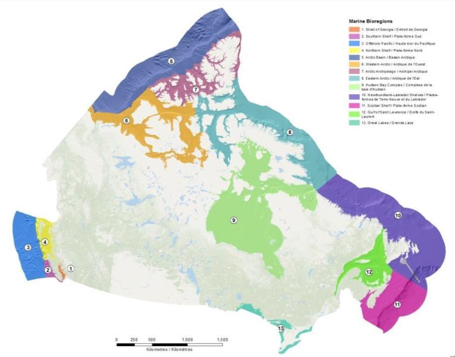
3 Bioregions
4 Challenge In each bioregion, use the extensive amount of available ecological and human-use data to design a comprehensive, resilient, and representative network of marine protected areas Respect existing rights and activities Meet conservation goals while minimizing potential socio-economic impacts 4
5 Part 1: Setting the Stage A structured process is needed for consistency across bioregions Objectives hierarchy:» National Goals» Strategic Objectives» Conservation Priorities»Design Strategies (Targets) Broad Specific 5
6 National Goals High-level statements that outline what the National MPA Network aims to achieve: 1) To provide long-term protection of marine biodiversity, ecosystem function and special natural features. 2) To support the conservation and management of Canada's living marine resources and their habitats, and the socio-economic values and ecosystem services they provide. 3) To enhance public awareness and appreciation of Canada's marine environments and rich maritime history and culture. 6
7 Objectives hierarchy:» National Goals»Strategic Objectives»Conservation Priorities»Design Strategies (Targets) 7
8 Strategic Objectives Statements that outline what a regional MPA network aims to achieve. Slightly different in each bioregion to take into account differences in environments and regional context Guide the identification of specific Conservation Priorities to be captured in the network 8
9 Examples of Strategic Objectives Help maintain ecosystem structure, functioning and resilience within the bioregion Provide protection for marine areas that contain unique or rare features (populations, communities, species or habitats) Protect representative examples of identified ecosystem and habitat types in the bioregion Help protect species at risk and their habitats to ensure their survival and possibly improve their state 9
10 Objectives hierarchy:» National Goals»Strategic Objectives»Conservation Priorities»Design Strategies (Targets) 10
11 Conservation Priorities Individual populations or species, groups of species, habitats, communities, ecological processes or other ecological features Selection of Conservation Priorities guided by: The Strategic Objectives Data availability Data quality Suitability of feature for spatial protection 11
12 Examples of Conservation Priorities Eelgrass beds Atlantic cod distribution Vazella pourtalesi (sponge) concentrations Areas of high fish species richness Representative oceanographic areas Species of Aboriginal importance Forage fish species (capelin) 12

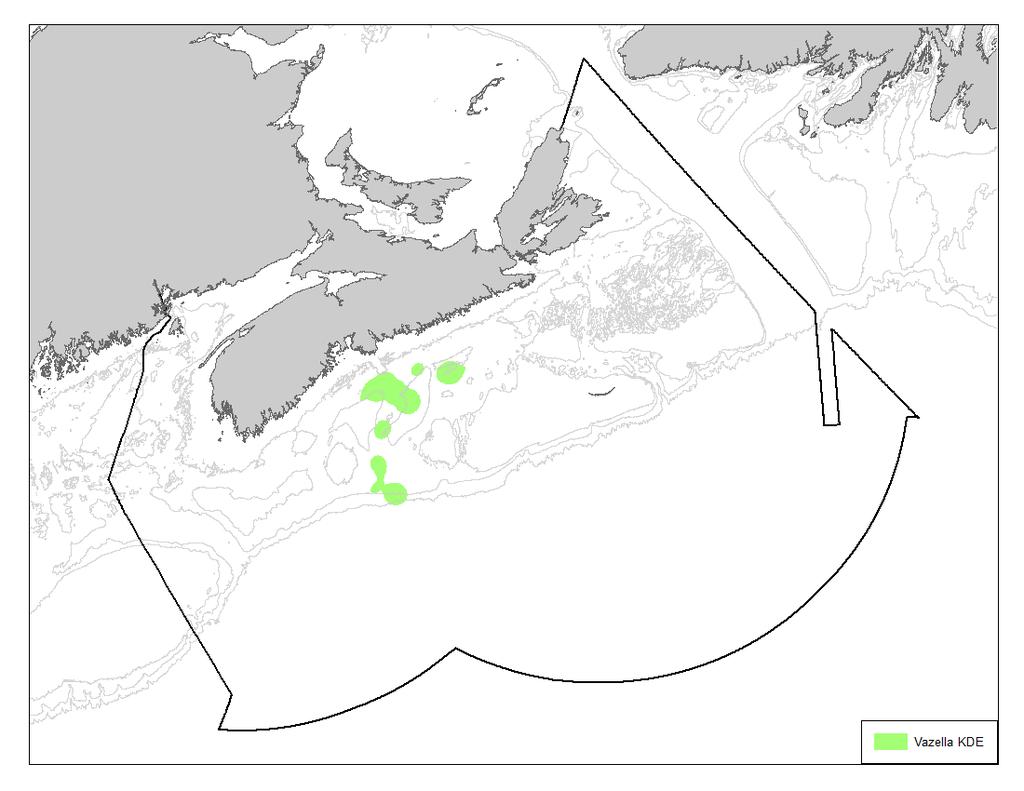
13 Examples of Conservation Priorities
14 Objectives hierarchy:» National Goals»Strategic Objectives»Conservation Priorities»Design Strategies (Targets) 14
15 Design Strategies Statements that specify the type and target for each Conservation Priority i.e., what specifically is being targeted, and how much should be captured in the network? Vazella sponge example: Type: Significant concentrations of Vazella Target: Capture % of this feature in the network 15
16 Specifying targets: Design Strategies Helps to measure success in capturing Conservation Priorities in the network Increases transparency in decision-making Science meetings (CSAS) in each bioregion to inform Design Strategies Indigenous information identified as a gap in Maritimes Region 16
17 Part 2: Network Design Analysis All 3 bioregions using Marxan to help design an MPA network that: Meets the ecological targets Minimizes socio-economic impacts Marxan does not give the final solution! Helps to identify key areas and explore trade-offs Good starting point for discussions 17
18 Marxan Decision Support Tool in Conservation Planning Adrian Gerhartz-Abraham
19 What is Marxan? 1. Most widely used decision support software for conservation planning globally 2. Intended to solve reserve design problem known as the minimum set problem (i.e., capture a set amount of biodiversity for the least cost)
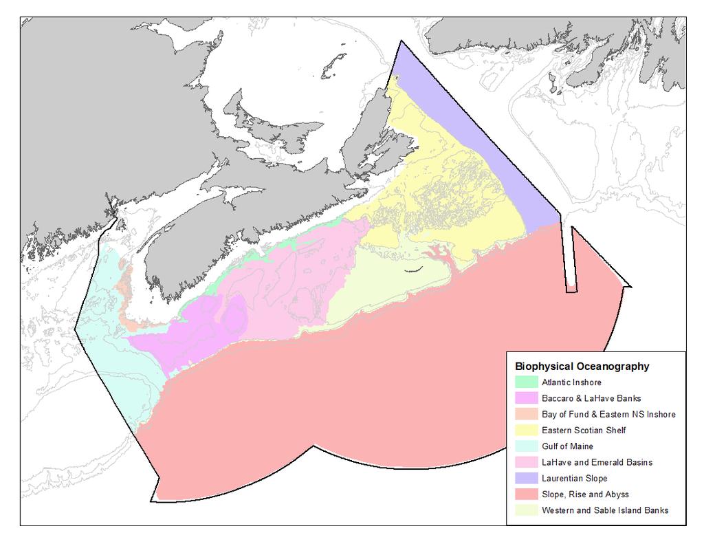
20 Marxan and conservation planning principles Representative Adequate Efficient Connectivity The ideal is to sample every kind of biodiversity 1. species (composition) 2. habitats (structure) 3. ecological processes (function) 4. ecological regions (biogeography) Also, sampling across the full range of variation of each feature (i.e., replication) Protecting enough to ensure persistence of biodiversity and continuity of ecological process that ensure ecosystem services. BUT How much is enough? Achieving objectives with a minimum cost, that is to say, with the least possible impact for all those involved Processes by which genes, organisms, populations, species, nutrients and/or energy move among spatially distinct habitats, populations, communities or ecosystems (MPA Center Report, 2017).
 2.")


21 How does a DST (e.g., Marxan) work in Protected Area planning? 1. The management area needs to be subdivided into planning units (PU) 2. Quantitative information (area) of each conservation priority for each PU e.g., Nursery habitat Kelp distribution = 3 km 2 1km Quantitative targets for each conservation priority that the system will aim to capture e.g., 33% (~1 Km 2 ) target of habitat distribution to be captured in the system 4. A cost associated to each PU (e.g., Area as a surrogate of management cost; Landings value as a surrogate of importance for fisheries; etc.) 3 4

22 What does Marxan do? Identifies a group of sites which meet conservation targets for a range of biodiversity features for a minimal cost Problem : Protect 1 km 2 of kelp habitat for the least impact High Fishing Activity Scenarios Low Fishing Activity A B C D Most efficient D: target met with the smallest impact Low impact but Target not met Target met but medium impact Target met but high Impact Marxan does not provide final answers but it is a tool to support decision-making
23 Marxan Objective: In Summary 1. Minimize: a) The total Cost of the reserve network b) Total Boundary of the reserve network 2. While meeting all conservation targets (i.e., minimizing the penalties for not adequately representing conservation features)
24 Benefits of using Marxan Useful to see how goals/objectives translate into reserve options Provides many good solutions and can be flexible for stakeholder engagement Incorporates different kinds of data to solve complex reserve design problems Identification of key locations (both for conservation and for not allocating reserves)
25 Benefits of using Marxan Addresses core conservation planning principles (Representation; Adequacy; Efficiency) Selects areas in a systematic, repeatable and transparent manner Facilitates the exploration of trade-offs between socio-economic and ecological objectives
26 Data inputs: Marxan Analysis Ecological data layers representing each Conservation Priority Human-use data layers For use in Marxan, human-use data must be: Georeferenced Converted to the same unit 26
27 Fisheries Data Commercial fisheries data is the main humanuse input into Marxan Data available for most commercial fisheries Want to avoid the most important areas for commercial fisheries where possible Data can easily be converted into the same units (e.g., landing by weight) 27

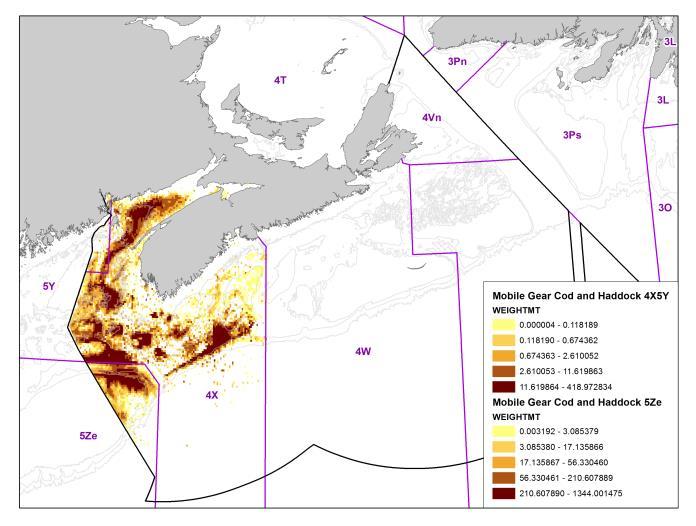
28 Fisheries Data Examples
29 Other Human-Use Data Other examples of human-use data to be considered at the network design stage (either in Marxan or post-marxan): Culturally important areas and uses Aquaculture sites Oil and gas production and significant discovery licenses Utility corridors (e.g., under sea cables) Other industrial developments (e.g., tidal energy) Shipping traffic 29
 as a starting point 54 EBSAs described in the coast based on expert opinion and")
30 Coastal EBSAs and Eco-Units Coastal Process in the Scotian Shelf Bioregion Different approach being used in the coastal planning area not using Marxan Ecological data in the coast is mostly descriptive in nature, with many gaps Relying on the use of Ecologically and Biologically Significant Areas (EBSAs) as a starting point 54 EBSAs described in the coast based on expert opinion and local knowledge 30
31 Data Gaps Work is being done to fill information gaps, such as: Indigenous information Connectivity data Spatial gaps (e.g., deep waters) 31
32 The MPA Network Design A network design is not the final picture Gives a general idea of priority sites for future protection It is a long-term plan for each bioregion Will be adjusted over time as new information comes in 32
33 The MPA Network Design New AOIs to be selected based on the draft MPA network designs starting in 2017 Each new MPA will have distinct information collection and consultation processes 33
34 Part 3. Timelines Release draft MPA network design* Finalize MPA network design Design and implement individual sites Consultation to inform on process and collect information Consultation on draft design Consultation on site design 34
35 Opportunities Still considering new information for development of draft MPA network designs (2017) Opportunity for input during consultation period on draft designs (2018), including Indigenous information New scientific data, Indigenous information, and human-use information will factor into future iterations of the MPA network designs (2018- onward) and at site level implementation 35


36 Thank you Maxine Westhead
37 Resource Slides
38 How Oceans Act MPAs are Created Step 1: Select Area of Interest (AOI) Engage stakeholders (ongoing during the designation process) Create a multi-stakeholder advisory body Step 2: Conduct overview and assessment of AOI Overview of available ecological and human use information Assess potential risk of human activities to the ecosystem Step 3: Develop regulatory intent Describes proposed boundaries and management scenario Cost benefit analysis Consult through advisory body and other mechanisms Step 4: Develop regulatory documents and designate the MPA Publish in Canada Gazette (includes public consultation period) Step 5: MPA management Research and monitoring, education and outreach, activity approvals, etc.
39 MPA Network Development in NL Shelves Bioregion (proposed timeline) Phase 1 Gather data & information Phase 2 Design MPA network Advance opportunities Phase 3 Create and implement Action Plan Phase 4 Monitor and manage sites Gather information and consult on MPA Network Objectives Consult on potential MPA Network Design Scenarios Finalize MPA Network Design Consult


40 NL Shelves Bioregion: Communitybased Coastal Resource Inventory From 1996 to 2009 twenty-two individual LEK data collection exercises were undertaken which cover the entire DFO NL Region This is a spatial database collected through interviews with local residents with an interest in participating. Mostly commercial fishers Data collected on the following themes, Groundfish, Pelagics, Shellfish Marine Mammals, Aquatic Plants, Aquaculture, Infrastructure, Culture Tourism and Recreation, Shoreline Classification (Scale 1:50,000) 40
41 Examples of Stakeholder Identified Conservation Priorities in the NL Shelves Bioregion 1. Atlantic Cod 2. Coral and Sponges 3. At Risk Species 4. Marine Habitats 5. Marine birds 6. Cetaceans 7. Species of Aboriginal Importance 8. Forage Fish Species (capelin)


42 Mapping Commercial Logbook Data using the Coastal Community Resource Inventory Community Coastal Resource Inventory Areas for a given fishery are mapped. In this case the Cod fixed gear fishery Marxan Planning Units which overlay these areas are extracted to represent the footprint of that fishery inshore Non-georeferenced points with associated logbook values are distributed by NAFO Zone to the CCRI planning units. Georeferenced points are mapped as per usual. 42

43 NL Shelves Bioregion: Offshore Local Ecological Knowledge Survey In 2012 a LEK survey was conducted through a personal services contract Fifteen fishers were interviewed from several communities along the southern Labrador coast Extra emphasis was placed on trying to identify special areas or areas worthy of conservation attention
44 Identifying Design Strategies (EGSL) What? Percentage associated to each CP Why? It quantifies strategic conservation objectives Helps measure the achievement of results for the MPA network How? Different scenarios = various conservation levels
45 Identifying Design Strategies (EGSL) Minimum target = 10% - CBD expert workshop (Nagoya, 2010) - Québec City (2011) - "medium" and "high" targets Targets selected for basic scenarios for all conservation priorities: 10% - 20 % - 30% Defining criteria for assigning higher targets
46 Identifying Design Strategies (cont.) Different CPs, different conservation level: Increase targets if the conservation level is higher, e.g., species at risk: 20% - 30% - 40% Other criteria for assigning higher targets than those in basic scenarios: Number of COs per CP Species of particular interest "Direct" vs. "substitute" data "Integrated" or "non-integrated" data
Marine Protected Area Network Planning in the Bay of Fundy and Scotian Shelf. Progress to date and next steps
 Marine Protected Area Network Planning in the Bay of Fundy and Scotian Shelf Progress to date and next steps Max(ine) Westhead, M.Sc. Section Head, Protected Areas and Conservation Planning Fisheries and
DFO Maritimes Region Update. Gulf of Maine Council - Coastal and Marine Spatial Planning (CMSP) Committee Web-Ex May 16, 2017
 Committee Web-Ex May 16, 2017") DFO Maritimes Region Update Gulf of Maine Council - Coastal and Marine Spatial Planning (CMSP) Committee Web-Ex May 16, 2017 1 National Oceans Priorities Marine Conservation Targets Oceans Protection Plan
DFO Maritimes Region Update Gulf of Maine Council - Coastal and Marine Spatial Planning (CMSP) Committee Web-Ex May 16, 2017 1 National Oceans Priorities Marine Conservation Targets Oceans Protection Plan
Outline National legislative & policy context Regional history with ESSIM ESSIM Evaluation Phase Government Integration via RCCOM Regional ICOM Framew
 What MSP Implementation could change in the Maritimes Region Tim Hall, Regional Manager Oceans and Coastal Management Division Ecosystem Management Branch Fisheries and Oceans Canada Maritimes Region BIO
Spatial Planning in Canada s Maritimes Region. Maritimes Region
 Spatial Planning in Canada s Maritimes Region Glen Herbert, Scott Coffen-Smout Smout,, and Tanya Koropatnick Oceans and Coastal Management Division Ecosystem Management Branch Fisheries and Oceans Canada
Spatial Decision-Support for National Marine Conservation Areas in the Southern Strait of Georgia and Gwaii Haanas
 Spatial Decision-Support for National Marine Conservation Areas in the Southern Strait of Georgia and Gwaii Haanas Lindsay McBlane Krista Royle Greg MacMillan Photo: Mark Hiebert Western and Northern Service
EASTERN SCOTIAN SHELF INTEGRATED OCEAN MANAGEMENT PLAN
 Government of Canada Gouvernement du Canada EASTERN SCOTIAN SHELF INTEGRATED OCEAN MANAGEMENT PLAN SUMMARY Photo Credits: Bedford Institute of Oceanography Published by: Oceans and Habitat Branch Fisheries
Cross-border Maritime Spatial Plan for the Black sea - Romania and Bulgaria project
 Cross-border Maritime Spatial Plan for the Black sea - Romania and Bulgaria project in Romania and Bulgaria Plan Presentation A first step in the management of the marine areas of Romania and Bulgaria
Marine Spatial Planning Leslie-Ann McGee Battelle Memorial Institute
 Marine Spatial Planning Leslie-Ann McGee Battelle Memorial Institute Rev061708 1 Marine Spatial Planning What is it? Why is it different? Where is it currently being employed? What is happening in the
REGIONAL OCEANS PLAN
 FISHERIES AND OCEANS CANADA MARITIMES REGION 2016 REGIONAL OCEANS PLAN SCOTIAN SHELF ATLANTIC COAST BAY OF FUNDY Progress Report 2014-2016 Fisheries and Oceans Canada Pêches et Océans Canada Implementing
2012 FORUM OF MARINE PROTECTED AREAS IN THE MEDITERRANEAN ANTALYA, TURKEY
 2012 FORUM OF MARINE PROTECTED AREAS IN THE MEDITERRANEAN ANTALYA, TURKEY SPECIAL EVENT Challenges for Open Seas MPAs in the Mediterranean region November 27, 2012. 15h00-16H00 Slide # 1 2012 FORUM OF
A TOOLKIT FOR MARINE SPATIAL PLANNING Version: 17 July, 2009
 A TOOLKIT FOR MARINE SPATIAL PLANNING Version: 17 July, 2009 NEED FOR MARINE SPATIAL PLANNING The health of marine ecosystems is declining, and use conflicts in the marine environment are increasing, in
Marine Spatial Planning (MSP): A practical approach to ecosystembased
: A practical approach to ecosystembased") Marine Spatial Planning (MSP): A practical approach to ecosystembased management Erik Olsen, Institute of Marine Research, Norway Fanny Douvere, International Oceanographic Commission Overview Why we need
Marine Spatial Planning (MSP): A practical approach to ecosystembased management Erik Olsen, Institute of Marine Research, Norway Fanny Douvere, International Oceanographic Commission Overview Why we need
TOWARDS CLIMATE-RESILIENT COASTAL MANAGEMENT: OPPORTUNITIES FOR IMPROVED ICZM IN BELIZE
 TOWARDS CLIMATE-RESILIENT COASTAL MANAGEMENT: OPPORTUNITIES FOR IMPROVED ICZM IN BELIZE CHANTALLE SAMUELS Coastal Zone Management Authority and Institute The Caribbean Community Climate Change Centre VULNERABILITY
BALANCE WP4: Development of a Baltic Sea marine area management framework. - with key inputs from WP1, WP2 & WP3
 BALANCE WP4: Development of a Baltic Sea marine area management framework - with key inputs from WP1, WP2 & WP3 BALANCE Kick-Off meeting, Copenhagen, 31 Aug-1 Sept 2005 Contents of the presentation: 1.
Marine/Maritime Spatial Planning Andrej Abramić
 Marine/Maritime Spatial Planning Andrej Abramić EcoAqua SUMMER SCHOOL: Ecosystem approach to aquaculture 26-29th of October 2015 Research and Technology to enhance excellence in Aquaculture development
Identifying Sensitive Marine Areas: A tour of the legal and scientific criteria
 Identifying Sensitive Marine Areas: A tour of the legal and scientific criteria CIL High Seas Governance: Gaps and Challenges Panel 1 on Sensitive Marine Areas 24-25 April 2017, Singapore Youna Lyons,
SPLAN-Natura Towards an integrated spatial planning approach for Natura th January, 2017 Brussels. Commissioned by DG Environment
 SPLAN-Natura 2000 Towards an integrated spatial planning approach for Natura 2000 Commissioned by DG Environment 17 th January, 2017 Brussels V. Simeonova (Ph.D.) Drivers towards integrating Biodiversity
Developing a Regulatory Framework for the Deep Sea Mineral Exploitation.
 Developing a Regulatory Framework for the Deep Sea Mineral Exploitation. Stakeholder Survey Submission to the United National International Seabed Authority (UN ISA). Benjamin Kahn 1 May 2014 1 Director
MARINE STUDIES (MARINE SPATIAL PLANNING & MANAGEMENT) MASTER S DEGREE
 MASTER S DEGREE") MARINE STUDIES (MARINE SPATIAL PLANNING & MANAGEMENT) MASTER S DEGREE Influence, lead and provide decision making support for the management and planning of coastal and marine spaces. PROGRAM DESCRIPTION
MARINE STUDIES (MARINE SPATIAL PLANNING & MANAGEMENT) MASTER S DEGREE Influence, lead and provide decision making support for the management and planning of coastal and marine spaces. PROGRAM DESCRIPTION
National Perspectives - Portugal. Margarida Almodovar
 National Perspectives - Portugal Margarida Almodovar margarida.almodovar@mam.gov.pt from base line to the external limit of the continental shelf behind 200 miles and according to UNCLOS definitions Economic
Marine Spatial Planning: A Tool for Implementing Ecosystem-Based Management
 Marine Spatial Planning: A Tool for Implementing Ecosystem-Based Management Steven Murawski, Ph.D., Ecosystem Goal Team Lead National Oceanic and Atmospheric Administration NOAA November 16, 2009 1 To
REVIEW OF ALTERNATE BALLAST WATER EXCHANGE ZONES FOR VESSEL TRAFFIC TO NEWFOUNDLAND AND LABRADOR AND THE CANADIAN ARCTIC
 Canadian Science Advisory Secretariat Science Advisory Report 2010/026 REVIEW OF ALTERNATE BALLAST WATER EXCHANGE ZONES FOR VESSEL TRAFFIC TO NEWFOUNDLAND AND LABRADOR AND THE CANADIAN ARCTIC Figure 1:
Outline. - Background of coastal and marine conservation - Species distribution modeling (SDM) - Reserve selection analysis. - Results & discussion
 - Reserve selection analysis. - Results & discussion") Application of GIS for data preparation and modeling for coastal and marine conservation planning in Madagascar Rija Rajaonson Technical Assistant, REBIOMA Wildlife Conservation Society Madagascar Outline
Application of GIS for data preparation and modeling for coastal and marine conservation planning in Madagascar Rija Rajaonson Technical Assistant, REBIOMA Wildlife Conservation Society Madagascar Outline
Natural Resource Management. Northern Tasmania. Strategy. Appendix 2
 Natural Resource Management Strategy Northern Tasmania 2015 2020 Appendix 2 Appendix 2 Appendix 2. Carbon Planting Spatial Prioritisation In support of this Strategy s development and implementation, work
MARINE SPATIAL PLANNING
 MARINE SPATIAL PLANNING Washington Uses Spatial Planning to Honor its Pacific Coast and Offshore Waters Past, Present and Future The Washington State Pacific Coast and offshore waters are diverse in both
Community Mapping Network. Selected Coastal Atlases and Information Systems in British Columbia, Canada
 Community Mapping Network Selected Coastal Atlases and Information Systems in British Columbia, Canada Outline Community Mapping Network cmnbc.ca Pacific Coastal Resources Atlas for BC cmnbc.ca The Living
1. Baltic SCOPE Towards coherence and cross-border solutions in Baltic Maritime Spatial Plans
 NSHC 32th Conference Explanatory Note Dublin, Ireland Item E.2 MSP 21-23 June 2016 Germany Cross border MSP for the EEZ, a case study from the Baltic Sea The Federal Maritime and Hydrographic Agency of
Mapping Maine s Working Waterfront: for Our Heritage and Economy
 Mapping Maine s Working Waterfront: for Our Heritage and Economy Abstract Mapping Maine s Working Waterfronts is a collaborative project led by the Island Institute that inventories the state s current
Natura 2000 in the marine environment: state of implementation and next steps
 Life on the blue planet: biodiversity research and the new European marine policies EPBRS European Platform on Biodiversity Research Strategy Porto, Portugal 7-9 November 2007 Natura 2000 in the marine
Framework for the Basin-Wide Socio-Economic Analysis of Four Proposed Sediment Diversions. August 4, 2015
 Framework for the Basin-Wide Socio-Economic Analysis of Four Proposed Sediment Diversions August 4, 2015 Proposed Sediment Diversions Mid-Breton Mid-Barataria Lower Barataria Lower Breton Overview of Presentation
Introduction: The Gulf of Mexico Alliance. The Gulf GAME project MERMAid and PHINS Results & Conclusions What s next? Examples
 AAG Las Vegas March 25, 2009 Introduction: Ocean governance and Ecosystem-Based Management The Gulf of Mexico Alliance Habitat Identification and Characterization The Gulf GAME project MERMAid and PHINS
IMA s ROLE IN COASTAL AND OCEAN GOVERNANCE IN TRINIDAD AND TOBAGO
 IMA s ROLE IN COASTAL AND OCEAN GOVERNANCE IN TRINIDAD AND TOBAGO Presented by Rahanna Juman, Deputy Director (Ag.) About the Institute of Marine Affairs Institute of Marine Affairs (IMA) was established,
Marine Spatial Planning as an important tool for implementing the MSFD
 Marine Spatial Planning as an important tool for implementing the MSFD Risto Kalliola Tallinn, Nov. 16 th 2012 DEPARTMENT OF GEOGRAPHY AND GEOLOGY University of Turku, Finland Ten principles to provide
Ensuring Access to Marine Areas for Offshore Oil and Gas
 Ensuring Access to Marine Areas for Offshore Oil and Gas Paul Holthus Executive Director World Ocean Council paul.holthus@oceancouncil.org The international business alliance for Corporate Ocean Responsibility
2001 State of the Ocean: Chemical and Biological Oceanographic Conditions in the Newfoundland Region
 Stock Status Report G2-2 (2) 1 State of the Ocean: Chemical and Biological Oceanographic Conditions in the Background The Altantic Zone Monitoring Program (AZMP) was implemented in 1998 with the aim of
Dorset MSP Evidence Base 18 th February Ness Smith C-SCOPE Project Officer
 Dorset MSP Evidence Base 18 th February 2011 Ness Smith C-SCOPE Project Officer Sectoral Topic Papers MMA Description document gives an overview of the area, it s physical and human influences 20 Topic
International Guidelines for Ecosystem-based, Marine Spatial Management
 International Guidelines for Ecosystem-based, Marine Spatial Management Charles Ehler and Fanny Douvere, Consultants Intergovernmental Oceanographic Commission and Man and the Biosphere Programme UNESCO
Courtesy of John Mitchell
 Shrimp trawl fisheries Marine fish stocks are under increasing threat from a range of spatially based problems that might be natural or involve socio-economic factors. To best manage spatial problems,
Natural Resource Management Strategy. Southern Tasmania. Summary. Natural Resource Management Strategy for Southern Tasmania Summary
 Natural Resource Management Strategy Summary Southern Tasmania 2015 2020 Natural Resource Management Strategy for Southern Tasmania 2015 2020 - Summary i Disclaimer In developing this Strategy, every effort
Implementation of the Political Declaration on energy cooperation between the North Seas Countries. Support Group 1 on Maritime Spatial Planning
 Implementation of the Political Declaration on energy cooperation between the North Seas Countries Support Group 1 on Maritime Spatial Planning Work Programme 1. Work area as outlined in Annex I to the
Arctic ecosystem services: TEEB Arctic Scoping study. Alexander Shestakov WWF Global Arctic Programme 3 December Arctic Biodiversity Congress
 Arctic ecosystem services: TEEB Arctic Scoping study Alexander Shestakov WWF Global Arctic Programme 3 December 20143 Arctic Biodiversity Congress Content 1. Project design 2. Approach 3. Challenges and
Why do we need a global framework for MPAs in ABNJ? Kristina M. Gjerde IUCN High Seas Policy Advisor
 Why do we need a global framework for MPAs in ABNJ? Kristina M. Gjerde IUCN High Seas Policy Advisor kgjerde@eip.com.pl 40% ocean heavily affected by humans (c) Halpern et al. 2008. Scientists found that
Mapping ecosystem services provided by benthic habitats in the European Atlantic Ocean
 Mapping and Assessment Ecosystem Services and Links to Good Environmental Status Mapping ecosystem services provided by benthic habitats in the European Atlantic Ocean Ibon Galparsoro, Angel Borja and
Australia s Marine Bioregional Planning
 Australia s Marine Bioregional Planning And possible lessons for areas beyond national jurisdiction Nautilus (Dr M. Norman, Museum Victoria) Butterfly fish & Yellowback Fusiliners (R.Thorn) Soft coral
Major human activities affecting Norwegian coastal marine ecosystems; present status and challenges
 Major human activities affecting Norwegian coastal marine ecosystems; present status and challenges Erlend Moksness PICES Annual Meeting - Science Board Symposium 26. October 2009, Jeju, Korea FUTURE:
Terms of Reference for the Comparative Environmental Review (CER) of. Options for the Mactaquac Project, Mactaquac, New Brunswick
 of. Options for the Mactaquac Project, Mactaquac, New Brunswick") Terms of Reference for the Comparative Environmental Review (CER) of Options for the Mactaquac Project, Mactaquac, New Brunswick Preamble The New Brunswick Power Corporation ( NB Power ) operates the Mactaquac
Terms of Reference for the Comparative Environmental Review (CER) of Options for the Mactaquac Project, Mactaquac, New Brunswick Preamble The New Brunswick Power Corporation ( NB Power ) operates the Mactaquac
Seismic Surveys Regulatory Process
 Seismic Surveys Regulatory Process SEISMIC WORKSHOP RAMADA INN/MARINE INSTITUTE, ST. JOHN S, NL NOVEMBER 1 2, 2006 Seismic Surveys: Regulatory Process Brief overview of C-NLOPB Historical overview of seismic
Geospatial Decision Support Tools for Planning of Marine Protected Areas in California
 Geospatial Decision Support Tools for Planning of Marine Protected Areas in California WILL MCCLINTOCK (UNIVERSITY OF CALIFORNIA SANTA BARBARA), MATT MERRIFIELD (THE NATURE CONSERVANCY), SOPHIE DE BEUKELAER
Marine ecosystem mapping at the Prince Edward Islands
 Marine ecosystem mapping at the Prince Edward Islands Biodiversity Planning Forum NBA special session June 2018 R Adams, C von der Meden, A Dayaram, K Sink, A Lombard, A Bosman, M Dopolo, F Fourie, L Harris,
Seabed knowledge In support of UN SDGs
 Seabed knowledge In support of UN SDGs Evert Flier Fiskerifaglig forum 2. november 2017 Hydrography & small scale fishing Hydrography in Transition Serving the Maritime Community Hydrography in Transition
Introduction and Project Overview
 Greater New Orleans Regional Land Use Modeling GIS Techniques in a P olitical C ontext Louisiana Remote Sensing and GIS Workshop Wednesday, April 24, 2013 Working Towards a Shared Regional Vision Introduction
Using Data and Evidence to Inform Marine Spatial Planning
 Coastwatch Workshop and Launch of 30 years of Coastwatch Data Using Data and Evidence to Inform Marine Spatial Planning Stephen Hull Overview What is MSP? What is MSP trying to achieve? Ireland s MSP process
15 March 2010 Re: Draft Native Vegetation of the Sydney Metropolitan Catchment Management Authority Area GIS layers and explanatory reports
 SYDNEY COASTAL COUNCILS GROUP Inc. C/- City of Sydney Council Level 14, 456 Kent Street GPO Box 1591, SYDNEY NSW 2001 Phone: (02) 9246 7791 Facsimile: (02) 9265 9660 Email: info@sydneycoastalcouncils.com.au
Country Fiche Lithuania
 Country Fiche Lithuania Updated June 2018 1. General information The Lithuanian maritime space is delimited by the Decree of the Government of the Republic of Lithuania of 6 December, 2004, No. 1597 and
NOAA s OCM: Services, tools and collaboration opportunities & Puerto Rico s NE Marine Corridor as a case study
 NOAA s OCM: Services, tools and collaboration opportunities & Puerto Rico s NE Marine Corridor as a case study Dr. Antares Ramos Álvarez NOAA s Office of Coastal Management September 15 th, 2016 Conservation
Opening their Shells Getting commercial clammers involved in marine spatial planning
 Opening their Shells Getting commercial clammers involved in marine spatial planning Ed Lewandowski Coastal Communities Development Specialist University of Delaware/Delaware Sea Grant Highlights Background
Ecologically or Biologically Significant Areas (EBSAs) in the Convention on Biological Diversity Arctic EBSA workshop as an example
 in the Convention on Biological Diversity Arctic EBSA workshop as an example") Ecologically or Biologically Significant Areas (EBSAs) in the Convention on Biological Diversity Arctic EBSA workshop as an example Ville Karvinen / SYKE HELCOM STATE & CONSERVATION 3-2015 12.11.2015 CBD
Ecologically or Biologically Significant Areas (EBSAs) in the Convention on Biological Diversity Arctic EBSA workshop as an example Ville Karvinen / SYKE HELCOM STATE & CONSERVATION 3-2015 12.11.2015 CBD
Multi-sector biodiversity surveys: integrating federal, territorial and community-based surveys. Kevin J. Hedges
 Multi-sector biodiversity surveys: integrating federal, territorial and community-based surveys Kevin J. Hedges Outline Study area Research/stakeholder groups Recent integration Eastern Canadian Arctic
Lorna V Inniss, Ph.D SAGE Workshop, New York City
 Lorna V Inniss, Ph.D SAGE Workshop, New York City 2014-05-21 Why me? The globally recognized success of the Barbados ICZM programme has generated requests for technical assistance and CD from many Governments
Overview of Methods. Terrestrial areas that are most important for conservation Conservation
 Overview of Methods The goal of the Western Lake Erie Coastal Conservation Vision project (WLECCV) is to define where we should be working locally to optimally achieve regional conservation impact. The
ECOLOGICALLY AND BIOLOGICALLY SIGNIFICANT AREAS LESSONS LEARNED
 Canadian Science Advisory Secretariat Science Advisory Report 2011/049 ECOLOGICALLY AND BIOLOGICALLY SIGNIFICANT AREAS LESSONS LEARNED Context : Canada s Oceans Act (1997) authorises Fisheries and Oceans
WELCOME & INTRODUCTION
 MPA Management Capacity Building Training Module 1: WELCOME & INTRODUCTION Participants Distinguished Guests Welcome Site Overviews of MPAs represented Overview of Training Program What are Today s Objectives?
HELSINKI COMMISSION Baltic Marine Environment Protection Commission
 HELSINKI COMMISSION Baltic Marine Environment Protection Commission HELCOM RECOMMENDATION 24/10 Adopted 25 June 2003, having regard to Article 20, Paragraph 1 b) of the 1992 Helsinki Convention IMPLEMENTATION
Development of an International Arctic Observations Assessment Framework
 Development of an International Arctic Observations Assessment Framework Dr. Steven Lev, Dr. Jason Gallo Briefing for the Sustaining Arctic Observing Networks (SAON) April 7, 2017 International Partners
PROMOTING NATURE CONSERVATION AND SUSTAINABLE AGRICULTURAL DEVELOPMENT IN THE RURAL AREAS OF HONG KONG
 1 PROMOTING NATURE CONSERVATION AND SUSTAINABLE AGRICULTURAL DEVELOPMENT IN THE RURAL AREAS OF HONG KONG Director of Agriculture, Fisheries and Conservation Dr. LEUNG Siu-fai A STONE S THROW AWAY FROM
Katie Wagner. Submitted in partial fulfillment of the requirements for the degree of Master Marine Management
 Linking People to Places: Evaluating the Methodology of Collecting Human-Use Data From Conservation and Protection Officers for Coastal Marine Protected Area Planning in Nova Scotia By Katie Wagner Submitted
PARC NATUREL DE LA MER DE CORAIL. The planned management project. with 15 objectives. Jean-Michel Boré - IRD
 Jean-Michel Boré - IRD PARC NATUREL DE LA MER DE CORAIL The planned management project with 15 objectives 1 CHAPTER 1 Protected natural and cultural heritage OBJECTIVE 1 Carefully protect the ecosystems
Findings and recommendations from Central Baltic case
 W 1/1 Recommendations on transboundary planning from Baltic SCOPE Findings and recommendations from Central Baltic case Ingūna Urtāne Director of Spatial Planning Department of the Ministry of Environmental
An Environmental Profile of the Island of Jost Van Dyke, British Virgin Islands
 An Environmental Profile of the Island of Jost Van Dyke, British Virgin Islands Executive Summary including Little Jost Van Dyke, Sandy Cay, Green Cay and Sandy Spit This publication was made possible
Marine Spatial Planning in the Baltic Sea Region
 Marine Spatial Planning in the Baltic Sea Region Towards coherence and cross-border solutions in Baltic Maritime Spatial Plans Coordinator & Project manager Dr Ingela Isaksson Swedish Agency for Marine
HAMILTON DECLARATION ON COLLABORATION FOR THE CONSERVATION OF THE SARGASSO SEA
 HAMILTON DECLARATION ON COLLABORATION FOR THE CONSERVATION OF THE SARGASSO SEA Hamilton, Bermuda 11 March, 2014 WE, THE SIGNATORIES LISTED BELOW: Recognising that the islands of Bermuda are the only land
Maritime Spatial Planning Framework Directive Supported by INSPIRE
 Maritime Spatial Planning Framework Directive Supported by INSPIRE Andrej Abramić, Vanda Nunes de Lima, Paul Smits, Emanuele Bigagli, Chris Schubert European Commission Joint Research Centre Institute
World Oceans Day 2010 Our oceans: opportunities and challenges
 World Oceans Day 2010 Our oceans: opportunities and challenges Roundtable discussion on the United Nations Convention on the Law of the Sea fifteen years after its entry into force HOW EFFECTIVELY IS UNCLOS
ExxonMobil Canada Properties Hebron 2010 Geohazard Survey Environmental Assessment Report Review Comments GENERAL COMMENTS
 GENERAL COMMENTS For completeness, please include in ExxonMobil s response to these review comments the information provided to the C-NLOPB on April 21 and April 29, 2010 regarding the extension to the
A trans-atlantic assessment and deep-water ecosystem-based spatial management plan for Europe
 A trans-atlantic assessment and deep-water ecosystem-based spatial management plan for Europe This project has received funding from the European Union s Horizon 2020 research and innovation programme
Marine Spatial Planning Experience from Mecklenburg-Vorpommern (Germany) By Susan Toben
 By Susan Toben") Marine Spatial Planning Experience from Mecklenburg-Vorpommern (Germany) By Susan Toben Ministry of Transport, Building and Regional Development Mecklenburg Vorpommern PlanCoast Lead Partner Administrative
Marine Spatial Planning Experience from Mecklenburg-Vorpommern (Germany) By Susan Toben Ministry of Transport, Building and Regional Development Mecklenburg Vorpommern PlanCoast Lead Partner Administrative
Country Fiche Estonia
 Country Fiche Estonia Deleted: October Updated May 2018 Deleted: 7 1. General information Size of internal waters (to the baseline) and territorial sea (12-nm zone from the baseline) approximately 25 200
NORTH VANCOUVER ISLAND MARINE PLAN: OVERVIEW 2015
 NORTH VANCOUVER ISLAND MARINE PLAN: OVERVIEW 2015 North Vancouver Island Marine Plan Overview Refers to: Marine Planning Partnership Initiative. 2015. North Vancouver Island Marine Plan. Copyright 2015
MESMA: An integrated tool box to support an ecosystem based spatial management of marine areas
 MESMA: An integrated tool box to support an ecosystem based spatial management of marine areas Stelzenmüller, V., Stamford, T., Vassilopoulou, V., Kastanevakis, S., Vincx, M, Vanaverbeke, J., Rabaut, M.,
Da Nang Vietnam November 2015
 WORKSHOP Contribution of Valuation Economy Study to the zoning process for proposed Tun Mustapha Marine Park (TMP) and Semporna Marine Spatial Planning Da Nang Vietnam November 2015 Da Nang Vietnam November
Research Programme Polar, Marine and Coastal Systems. Current and future Arctic research priorities of Germany Nicole Biebow, AWI
 Research Programme Polar, Marine and Coastal Systems Current and future Arctic research priorities of Germany Nicole Biebow, AWI Arctic Science and Technology (S&T) Collaboration and Engagement Workshop,
The World Bank BZ Marine Conservation and Climate Adaptation (P131408)
") Public Disclosure Authorized LATIN AMERICA AND CARIBBEAN Belize Environment & Natural Resources Global Practice Recipient Executed Activities Investment Project Financing FY 2015 Seq No: 2 ARCHIVED on
Public Disclosure Authorized LATIN AMERICA AND CARIBBEAN Belize Environment & Natural Resources Global Practice Recipient Executed Activities Investment Project Financing FY 2015 Seq No: 2 ARCHIVED on
National Land Use Policy and National Integrated Planning Framework for Land Resource Development
 Title National Land Use Policy and National Integrated Planning Framework for Land Resource Development Duration: 32 Weeks Objective: Adoption of appropriate land use planning approaches to: Maintain the
Resolution XIII.23. Wetlands in the Arctic and sub-arctic
 13th Meeting of the Conference of the Contracting Parties to the Ramsar Convention on Wetlands Wetlands for a Sustainable Urban Future Dubai, United Arab Emirates, 21-29 October 2018 Resolution XIII.23
Getting Biodiversity Data
 Getting Biodiversity Data NatureServe Canada Douglas Hyde Executive Director Value of biodiversity data to business? Reasons vary depending on the business Reduce development uncertainty Integrated views
MODELS AND TOOLS FOR GOVERNANCE OF
 Working Papers Collection No. 1/2015 MODELS AND TOOLS FOR GOVERNANCE OF THE ADRIATIC AND IONIAN SEAS www.unimc.it/maremap NATIONAL POLITICS AND EU POLITICS: THE MARITIME SPATIAL PLANNING AND INTEGRATED
FISHERIES AND OCEANS CANADA MARITIMES REGION 2014 REGIONAL OCEANS PLAN SCOTIAN SHELF ATLANTIC COAST BAY OF FUNDY. Background and Program Description
 FISHERIES AND OCEANS CANADA MARITIMES REGION 2014 REGIONAL OCEANS PLAN SCOTIAN SHELF ATLANTIC COAST BAY OF FUNDY Background and Program Description Fisheries and Oceans Canada Pêches et Océans Canada Fisheries
The purpose of this report is to recommend a Geographic Information System (GIS) Strategy for the Town of Richmond Hill.
 Strategy for the Town of Richmond Hill.") Staff Report for Committee of the Whole Meeting Department: Division: Subject: Office of the Chief Administrative Officer Strategic Initiatives SRCAO.18.12 GIS Strategy Purpose: The purpose of this report
Staff Report for Committee of the Whole Meeting Department: Division: Subject: Office of the Chief Administrative Officer Strategic Initiatives SRCAO.18.12 GIS Strategy Purpose: The purpose of this report
Management Planning & Implementation of Communication Measures for Terrestrial Natura 2000 Sites in the Maltese Islands Epsilon-Adi Consortium
 Management Planning & Implementation of Communication Measures for Terrestrial Natura 2000 Sites in the Maltese Islands Epsilon-Adi Consortium Briefing Meetings, February 2013 CT3101/2011, MEPA, Malta
MARINE PROTECTED AREA NETWORK PLANNING IN THE SCOTIAN SHELF BIOREGION: OBJECTIVES, DATA, AND METHODS
 Canadian Science Advisory Secretariat Science Advisory Report 2012/064 MARINE PROTECTED AREA NETWORK PLANNING IN THE SCOTIAN SHELF BIOREGION: OBJECTIVES, DATA, AND METHODS Figure 1. Location of three planning
Assessment and valuation of Ecosystem Services for decision-makers
 Assessment and valuation of Ecosystem Services for decision-makers An introduction to the ARIES approach Ferdinando Villa *, Ken Bagstad Gary Johnson, Marta Ceroni *Basque Center for Climate Change, Bilbao,
Proper Data Management Responsibilities to Meet the Global Ocean Observing System (GOOS) Requirements
 Requirements") Data Buoy Cooperation Panel XXVI Oban, Scotland, UK 27 September 2010 Proper Data Management Responsibilities to Meet the Global Ocean Observing System (GOOS) Requirements William Burnett Data Management
Data Buoy Cooperation Panel XXVI Oban, Scotland, UK 27 September 2010 Proper Data Management Responsibilities to Meet the Global Ocean Observing System (GOOS) Requirements William Burnett Data Management
DELIVERING ECOSYSTEM- BASED MARINE SPATIAL PLANNING IN PRACTICE
 DELIVERING ECOSYSTEM- BASED MARINE SPATIAL PLANNING IN PRACTICE A first assessment for the UK and Ireland January 08 GLOBAL WARMING IMAGES / WWF ABOUT WWF WWF is the world s leading independent conservation
TOWARDS STRATEGIC SPATIAL PLANNING IN JAMAICA: THE NATIONAL SPATIAL PLAN
 TOWARDS STRATEGIC SPATIAL PLANNING IN JAMAICA: THE NATIONAL SPATIAL PLAN JIEP 5th Biennial Conference on the Environment: Balancing National Development and Environmental Protection June 6, 2011 Jamaica
Country Fiche Estonia
 Country Fiche Estonia Updated October 2017 1. General information Size of internal waters (to the baseline) and territorial sea (12-nm zone from the baseline) approximately 25 200 km 2. Exclusive economic
Environmental Risk from Ship traffic along the Norwegian Coast Odd Willy Brude, Det Norske Veritas, Veritasveien 1, 1322 Høvik, Norway
 Environmental Risk from Ship traffic along the Norwegian Coast 15.02.2012 Odd Willy Brude, Det Norske Veritas, Veritasveien 1, 1322 Høvik, Norway Marte Braathen, Det Norske Veritas, Veritasveien 1, 1322
ANNEX 5 IQALUIT 2015 SAO REPORT TO MINISTERS
 Submitted to Iqaluit Ministerial Meeting April 2015 Background In order to advance the ecosystem approach in the context of the Arctic Council, the Arctic Council Ministers established an expert group
ACRONYMS AREAS COUNTRIES MARINE TERMS
 Natura 2000 ACRONYMS AREAS COUNTRIES MARINE TERMS DEFINITION A European network of protected sites under the European Habitats and Birds Directives, aiming to protect the most valuable and threatened European