Opening their Shells Getting commercial clammers involved in marine spatial planning
|
|
|
- Clarence Burns
- 5 years ago
- Views:
Transcription


1 Opening their Shells Getting commercial clammers involved in marine spatial planning Ed Lewandowski Coastal Communities Development Specialist University of Delaware/Delaware Sea Grant

2 Highlights Background on Delaware Inland Bays Shellfish Aquaculture Initiative Marine Spatial Planning Using GIS and the wetable Engaging the affected interests Outcomes

3 College of Earth, Ocean & Environment
4 Issue Delaware is the only coastal state in the nation that does not allow commercial shellfish aquaculture! Local National Estuary Program (Center for the Inland Bays) leading efforts to pass enabling legislation to permit shellfish aquaculture 15 years of research and studies to prove feasibility and efficacy Help to invigorate commercial fishing economy Product is highly desired by area restaurants Local on the Menu
5 WHAT IS MARINE SPATIAL PLANNING? Comprehensive, adaptive, integrated, ecosystem-based, and transparent spatial planning process, based on sound science, for analyzing current and anticipated uses of ocean and coastal areas. Coastal and marine spatial planning identifies areas most suitable for various types or classes of activities in order to: reduce conflicts among uses, reduce environmental impacts, facilitate compatible uses, and preserve critical ecosystem services to meet economic, environmental, security, and social objectives
6 GIS Planning Goals Decrease user conflicts, improve planning and regulatory efficiencies and decrease costs and delays, and preserve critical ecosystem services Reduce conflicting Interests High Boat use regions and pathways would be primary conflicting use High density hard clam areas would consist of a conflicted use area Conflicting uses would be exclusion areas for aquaculture Optimally aquaculture lease areas would be located in areas with low conflicted interests or highly compatible uses Places science-based information at the heart of decision-making Emphasizes stakeholder and public participation

7 Rhode Island SAMP Presentation at Social Coast Forum in FEB 12 Engaging Stakeholders in Marine Spatial Planning Worked primarily with New England s ground fishing industry Used printed maps, crayons & markers, sticky notes, etc. Numerous data layers, so printed numerous maps
8 Human Use Data Navigational channels Historic channel dredging Marinas Public & private boat ramps Duck blinds
9 Regulatory Data Shellfish harvest closures

10 Physical Data Bathymetry Bottom sediment classifcations
 Seasonal colonial nesting")
11 Ecological Data Clam abundance (density) Seasonal colonial nesting bird habitat


12 Bart Wilson, Science Coordinator for the CIB, moderated the public engagement session

13 Several of the local commercial clammers and their family members participated

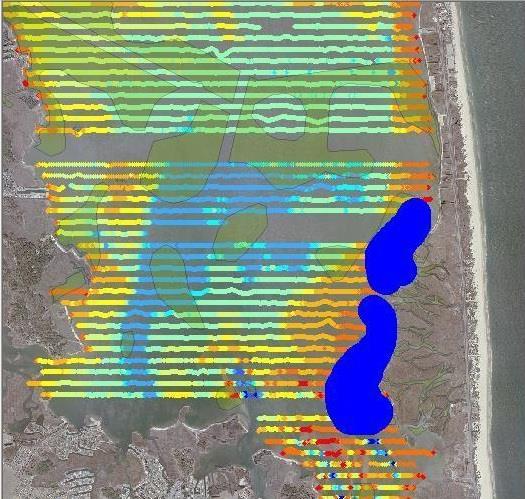
14 Bob s wetable markup

15 Tough converts!
16 Preferred Use Areas Low clam density (< 2 clams/m) Low boat traffic Open to harvest Little to no current commercial harvesting activity Limited waterfowling activity No shoreline residences

17 Leased Areas Example Created a map that depicts the proposed area with a variety of lease sizes and configurations Visual representation of the immediate geospatial impacts of the aquaculture activity on surface waters Helped to allay many fears that bays would be consumed with leases


18 Status??? Consensus to proceed from commercial clammers Draft legislation will be proposed when General Assembly reconvenes in mid-mar
Rhode Island Shellfish Management Plan, Version 2, November Appendix C The SMP Use Maps
 Rhode Island Shellfish Management Plan, Version 2, November 214 Appendix C The SMP Use Maps 1. Identifying Use Conflicts The SMP process undertook the task of developing use maps to document and highlight
Overview of Methods. Terrestrial areas that are most important for conservation Conservation
 Overview of Methods The goal of the Western Lake Erie Coastal Conservation Vision project (WLECCV) is to define where we should be working locally to optimally achieve regional conservation impact. The
Marine Spatial Planning: A Tool for Implementing Ecosystem-Based Management
 Marine Spatial Planning: A Tool for Implementing Ecosystem-Based Management Steven Murawski, Ph.D., Ecosystem Goal Team Lead National Oceanic and Atmospheric Administration NOAA November 16, 2009 1 To
MARINE SPATIAL PLANNING
 MARINE SPATIAL PLANNING Washington Uses Spatial Planning to Honor its Pacific Coast and Offshore Waters Past, Present and Future The Washington State Pacific Coast and offshore waters are diverse in both
NOAA Nautical Charts and Coastal and Marine Spatial Planning. Meredith Westington Chief Geographer NOAA/NOS/Office of Coast Survey
 NOAA Nautical Charts and Coastal and Marine Spatial Planning Meredith Westington Chief Geographer NOAA/NOS/Office of Coast Survey Ocean Policy Task Force What is CMSP? A comprehensive, adaptive, integrated,
Marine Spatial Planning as an important tool for implementing the MSFD
 Marine Spatial Planning as an important tool for implementing the MSFD Risto Kalliola Tallinn, Nov. 16 th 2012 DEPARTMENT OF GEOGRAPHY AND GEOLOGY University of Turku, Finland Ten principles to provide
A Comparison of the Social Valuation of Ecosystem Services in Urban and Rural Contexts
 A Comparison of the Social Valuation of Ecosystem Services in Urban and Rural Contexts Jarrod L. Loerzel College of Charleston Zachary D. Cole University of Florida Presentation Map 1. What is SolVES?
National Perspectives - Portugal. Margarida Almodovar
 National Perspectives - Portugal Margarida Almodovar margarida.almodovar@mam.gov.pt from base line to the external limit of the continental shelf behind 200 miles and according to UNCLOS definitions Economic
Marine Spatial Planning Leslie-Ann McGee Battelle Memorial Institute
 Marine Spatial Planning Leslie-Ann McGee Battelle Memorial Institute Rev061708 1 Marine Spatial Planning What is it? Why is it different? Where is it currently being employed? What is happening in the
Sediment Management in the Coastal Bays
 Sediment Management in the Coastal Bays Introduction Need for ecosystem view of sediment management in Coastal Bays Island loss and restoration Navigation needs Habitat Trade offs Living Shoreline Requirements
LA POLÍTICA MARÍTIMA INTEGRADA
 LA POLÍTICA MARÍTIMA INTEGRADA Ministerio de Agricultura, Alimentación y Medio Ambiente Juan Luís Suárez de Vivero 2 4 de abril de 2014, Madrid INTEGRATED MARINE POLICY 1. PLANES, MARCO JURÍDICO-ADMINISTRATIVO,
A National Ocean Policy for Malaysia: Rationale and Proposed Components. Mohd Nizam Basiron and Cheryl Rita Kaur Maritime Institute of Malaysia
 A National Ocean Policy for Malaysia: Rationale and Proposed Components Mohd Nizam Basiron and Cheryl Rita Kaur Maritime Institute of Malaysia Outline of Presentation Objectives of Presentation Introduction
Introduction: The Gulf of Mexico Alliance. The Gulf GAME project MERMAid and PHINS Results & Conclusions What s next? Examples
 AAG Las Vegas March 25, 2009 Introduction: Ocean governance and Ecosystem-Based Management The Gulf of Mexico Alliance Habitat Identification and Characterization The Gulf GAME project MERMAid and PHINS
Marine/Maritime Spatial Planning Andrej Abramić
 Marine/Maritime Spatial Planning Andrej Abramić EcoAqua SUMMER SCHOOL: Ecosystem approach to aquaculture 26-29th of October 2015 Research and Technology to enhance excellence in Aquaculture development
Relatively little hard substrate occurs naturally in the
 CHAPTER FIVE Rock Habitats Relatively little hard substrate occurs naturally in the estuary, owing mainly to the vast quantities of fine sediment that have been deposited by the rivers. Rock habitat is
PART I - PROJECT IDENTIFICATION INFORMATION PART II - DOCUMENTATION
 No students reported this period Progress Report Project Update Report Reporting Period: 2/1/2014-1/31/2015 MIT Sea Grant College Program E38-300 292 Main Street, Cambridge, MA 02139 (617) 253-9305 PART
Designing Networks of Marine Protected Areas in DFO s Three Atlantic Bioregions
 Designing Networks of Marine Protected Areas in DFO s Three Atlantic Bioregions Presentation for Indigenous Protected Areas Workshop Max Westhead, DFO and Adrian Gerhartz-Abraham, Dalhousie March 29, 2017
Country Fiche Estonia
 Country Fiche Estonia Updated October 2017 1. General information Size of internal waters (to the baseline) and territorial sea (12-nm zone from the baseline) approximately 25 200 km 2. Exclusive economic
Marine Spatial Management Tool
 Marine Spatial Management Tool Marine Spatial Management Tool Support the marine spatial planning process with updated and reliable geospatial information Marine management is important to Norway with
Heather Schlosser Army Corps of Engineers Coastal Studies Group August 28, 2008
 Got sand? Regional Sediment Management in Orange County Heather Schlosser Army Corps of Engineers Coastal Studies Group August 28, 2008 Regional Sediment Management Regional sediment management recognizes
Alexandra Carvalho, Ph.D., GISP Kathy Fitzpatrick, P.E.
 Coastal Data Organization for Project Management and Coastal Planning Martin County, Florida Alexandra Carvalho, Ph.D., GISP Kathy Fitzpatrick, P.E. Outline County Coastal Programs Coastal Geodatabase
Mapping Maine s Working Waterfront: for Our Heritage and Economy
 Mapping Maine s Working Waterfront: for Our Heritage and Economy Abstract Mapping Maine s Working Waterfronts is a collaborative project led by the Island Institute that inventories the state s current
PartiSEApate Conference
 Baltic Maritime Spatial Planning Forum PartiSEApate Conference C r e a t i n g c o m m o n u n d e r s t a n d i n g B a l t i c M a r i t i m e S p a t i a l P l a n n i n g F o r u m B a l t i c M a
NORTH VANCOUVER ISLAND MARINE PLAN: OVERVIEW 2015
 NORTH VANCOUVER ISLAND MARINE PLAN: OVERVIEW 2015 North Vancouver Island Marine Plan Overview Refers to: Marine Planning Partnership Initiative. 2015. North Vancouver Island Marine Plan. Copyright 2015
Subaqueous Soils A A New Frontier in Soil Survey. By Jim Turenne
 Subaqueous Soils A A New Frontier in Soil Survey By Jim Turenne http://nesoil.com.sas Subaqueous History Traditional soil survey conducted on land. Not a lot of work in wetlands and tidal marshes until
Marine Spatial Planning (MSP): A practical approach to ecosystembased
: A practical approach to ecosystembased") Marine Spatial Planning (MSP): A practical approach to ecosystembased management Erik Olsen, Institute of Marine Research, Norway Fanny Douvere, International Oceanographic Commission Overview Why we need
Marine Spatial Planning (MSP): A practical approach to ecosystembased management Erik Olsen, Institute of Marine Research, Norway Fanny Douvere, International Oceanographic Commission Overview Why we need
Outline National legislative & policy context Regional history with ESSIM ESSIM Evaluation Phase Government Integration via RCCOM Regional ICOM Framew
 What MSP Implementation could change in the Maritimes Region Tim Hall, Regional Manager Oceans and Coastal Management Division Ecosystem Management Branch Fisheries and Oceans Canada Maritimes Region BIO
Applications of Geographic Information Systems (GIS) and Remote Sensing (RS) in Marine Spatial Planning
 and Remote Sensing (RS) in Marine Spatial Planning") Ryan Rezendes Dr. August and Dr. Wang NRS 509 Applications of GIS and Remote Sensing Overview and Annotated Bibliography Fall Semester 14 December 2017 Applications of Geographic Information Systems (GIS)
Ryan Rezendes Dr. August and Dr. Wang NRS 509 Applications of GIS and Remote Sensing Overview and Annotated Bibliography Fall Semester 14 December 2017 Applications of Geographic Information Systems (GIS)
Presented by: Bryan Bloch GIS Specialist DNREC Division of Watershed Stewardship
 Presented by: Bryan Bloch GIS Specialist DNREC Division of Watershed Stewardship Bryan Hall, AICP Sussex County Circuit Rider Planner, Office of State Planning Coordination, OMB November 19, 2012 UD Sustainable
Country Fiche Estonia
 Country Fiche Estonia Deleted: October Updated May 2018 Deleted: 7 1. General information Size of internal waters (to the baseline) and territorial sea (12-nm zone from the baseline) approximately 25 200
Marine Spatial Planning in Hellas; Recent Facts and Perspectives
 XXV FIG CONGRESS Engaging the Challenges, Enhancing the Relevance Kuala Lumpur, Malaysia 16 21 June 2014 Marine Spatial Planning in Hellas; Recent Facts and Perspectives Mrs. Chaiditsa BOLANOU Surveying
STAMP Spa)al Tools for Arc)c Mapping & Planning. Creating an interactive data tool to improve access and usability of Arctic data
al Tools for Arc)c Mapping & Planning. Creating an interactive data tool to improve access and usability of Arctic data") STAMP Spa)al Tools for Arc)c Mapping & Planning Creating an interactive data tool to improve access and usability of Arctic data Mission Provide easy access to physical, chemical, and biological data Network
STAMP Spa)al Tools for Arc)c Mapping & Planning Creating an interactive data tool to improve access and usability of Arctic data Mission Provide easy access to physical, chemical, and biological data Network
Aquaculture Spatial Planning: The case of Greece
 Aquaculture Spatial Planning: The case of Greece Nikos Anagnopoulos Panhellenic Association for Small-Medium sized Aquaculture Enterprises Panhellenic Association for Small-Medium sized Aquaculture Enterprises
A TOOLKIT FOR MARINE SPATIAL PLANNING Version: 17 July, 2009
 A TOOLKIT FOR MARINE SPATIAL PLANNING Version: 17 July, 2009 NEED FOR MARINE SPATIAL PLANNING The health of marine ecosystems is declining, and use conflicts in the marine environment are increasing, in
Setting Priorities for Eelgrass Conservation and Restoration. Robert Buchsbaum Massachusetts Audubon Society
 Setting Priorities for Eelgrass Conservation and Restoration Robert Buchsbaum Massachusetts Audubon Society Eelgrass habitat values A rich, productive habitat for many marine organisms Nursery habitat
Major human activities affecting Norwegian coastal marine ecosystems; present status and challenges
 Major human activities affecting Norwegian coastal marine ecosystems; present status and challenges Erlend Moksness PICES Annual Meeting - Science Board Symposium 26. October 2009, Jeju, Korea FUTURE:
VISION FOR THE FUTURE: Marine Spatial Planning in Belgium
 VISION FOR THE FUTURE: Marine Spatial Planning in Belgium Fanny Douvere, Consultant Intergovernmental Oceanographic Commission UNESCO, Paris, France PlanCoast Conference on Marine Spatial Planning Supetar
Marine Spatial Planning, a Norwegian user case NSHC33
 Marine Spatial Planning, a Norwegian user case NSHC33 Marine Spatial Management Tool Support the marine spatial planning process with updated and reliable geospatial information Marine management is important
TOWARDS CLIMATE-RESILIENT COASTAL MANAGEMENT: OPPORTUNITIES FOR IMPROVED ICZM IN BELIZE
 TOWARDS CLIMATE-RESILIENT COASTAL MANAGEMENT: OPPORTUNITIES FOR IMPROVED ICZM IN BELIZE CHANTALLE SAMUELS Coastal Zone Management Authority and Institute The Caribbean Community Climate Change Centre VULNERABILITY
Virginia Shoreline Mapping Tools
 Virginia Shoreline Mapping Tools December 15, 2017 Karen Duhring Center for Coastal Resources Management Virginia Institute of Marine Science College of William & Mary Virginia Shoreline Mapping Tools
BURGAS CASE STUDY: LAND-SEA INTERACTIONS. Dr. Margarita Stancheva
 BURGAS CASE STUDY: LAND-SEA INTERACTIONS Dr. Margarita Stancheva Name of presentation NEED FOR COHERENCE BETWEEN LAND AND SEA ACTIVITIES Name presenter Burgas is the fourth largest city in Bulgaria and
International Guidelines for Ecosystem-based, Marine Spatial Management
 International Guidelines for Ecosystem-based, Marine Spatial Management Charles Ehler and Fanny Douvere, Consultants Intergovernmental Oceanographic Commission and Man and the Biosphere Programme UNESCO
Realizing benefits of Spatial Data Infrastructure A user s perspective from Environment Agency - Abu Dhabi
 Realizing benefits of Spatial Data Infrastructure A user s perspective from Environment Agency - Abu Dhabi Anil Kumar Director, Environment Information Management 26 April 2012 Geospatial World Forum,
Country Fiche Lithuania
 Country Fiche Lithuania Updated June 2018 1. General information The Lithuanian maritime space is delimited by the Decree of the Government of the Republic of Lithuania of 6 December, 2004, No. 1597 and
Framework for the Basin-Wide Socio-Economic Analysis of Four Proposed Sediment Diversions. August 4, 2015
 Framework for the Basin-Wide Socio-Economic Analysis of Four Proposed Sediment Diversions August 4, 2015 Proposed Sediment Diversions Mid-Breton Mid-Barataria Lower Barataria Lower Breton Overview of Presentation
The Use of Geographic Information Systems to Assess Change in Salt Marsh Ecosystems Under Rising Sea Level Scenarios.
 The Use of Geographic Information Systems to Assess Change in Salt Marsh Ecosystems Under Rising Sea Level Scenarios Robert Hancock The ecological challenges presented by global climate change are vast,
Marine Transportation and Ocean Use
 Marine Transportation and Ocean Use Data Needs for Multi-Disciplinary Long-Term Planning 4 th Biennial TRB-CMTS Research and Development Conference Matt Campo Rutgers University 6/22/2016 Overview What
- West Africa. Abuja, Nigeria May Fredericton Canada Heeswijk The Netherlands Washington DC United States Adelaide Australia
 A Case Study in Land and Sea Data Interoperability Patricia GASPAR(Netherlands), Andrew HOGGARTH(Canade), Gordon JOHNSTON(UK), Charles de JONG(Netherlands) - West Africa Abuja, Nigeria - 6-10 May 2013
Introducing the. a partnership of
 Introducing the a partnership of Background Need for online atlas identified by managers and researchers to make coastal data available Shoreline data Ocean and coastal resources Sea-level rise potential
NOAA s OCM: Services, tools and collaboration opportunities & Puerto Rico s NE Marine Corridor as a case study
 NOAA s OCM: Services, tools and collaboration opportunities & Puerto Rico s NE Marine Corridor as a case study Dr. Antares Ramos Álvarez NOAA s Office of Coastal Management September 15 th, 2016 Conservation
Seabed knowledge In support of UN SDGs
 Seabed knowledge In support of UN SDGs Evert Flier Fiskerifaglig forum 2. november 2017 Hydrography & small scale fishing Hydrography in Transition Serving the Maritime Community Hydrography in Transition
National Marine Sanctuary Program
 National Marine Sanctuary Program NMSP/USGS Joint Seabed Mapping Initiative: September 2004 AA National Ocean Service National Marine Sanctuaries Interim Report September 2004 Background: Since 2002,
Management Planning & Implementation of Communication Measures for Terrestrial Natura 2000 Sites in the Maltese Islands Epsilon-Adi Consortium
 Management Planning & Implementation of Communication Measures for Terrestrial Natura 2000 Sites in the Maltese Islands Epsilon-Adi Consortium Briefing Meetings, February 2013 CT3101/2011, MEPA, Malta
Spatial Planning in Canada s Maritimes Region. Maritimes Region
 Spatial Planning in Canada s Maritimes Region Glen Herbert, Scott Coffen-Smout Smout,, and Tanya Koropatnick Oceans and Coastal Management Division Ecosystem Management Branch Fisheries and Oceans Canada
BOEM Marine Minerals Program
 BOEM Marine Minerals Program Restoring and Protecting Our Nation s Coasts through Stewardship of OCS Sand Resources SECOORA 2018 Annual Meeting May 22-24 Doug Piatkowski Douglas.piatkowski@boem.gov 703-787-1833
KUNMING FORUM ON UNITED NATIONS GLOBAL GEOSPATIAL INFORMATION MANAGEMENT CITIES OF THE FUTURE: SMART, RESILIENT
 KUNMING FORUM ON UNITED NATIONS GLOBAL GEOSPATIAL INFORMATION MANAGEMENT CITIES OF THE FUTURE: SMART, RESILIENT and SUSTAINABLE Yunnan Zhenzhuang Guest House, Kunming, China 10 12 May 2017 BACKGROUND CONCEPT
Abstract. Introduction
 Southern California Aquaculture Site Assessment Model Caitlyn Raines University of Redlands Master of Science in Geographic Information Systems Program Abstract The Southern California Aquaculture Site
A National Outer Continental Shelf Sand / Sediment Inventory
 A National Outer Continental Shelf Sand / Sediment Inventory Sand Resource Areas Lease Areas Lora Turner December 15, 2016 Restoring and Protecting Our Nation s Coasts through Stewardship of OCS Resources
Geospatial Decision Support Tools for Planning of Marine Protected Areas in California
 Geospatial Decision Support Tools for Planning of Marine Protected Areas in California WILL MCCLINTOCK (UNIVERSITY OF CALIFORNIA SANTA BARBARA), MATT MERRIFIELD (THE NATURE CONSERVANCY), SOPHIE DE BEUKELAER
The Urban Sea and Coastal Zone Management
 The Urban Sea and Coastal Zone Management David NEALE, Trinidad and Tobago Key words: hydrography, Caribbean, coastal zone management, land use. SUMMARY Within the coastal zone of Eastern Caribbean States,
ARCTIC FISHERIES: GOVERNANCE CHALLENGES AND OPPORTUNITIES
 Commentary ARCTIC FISHERIES: GOVERNANCE CHALLENGES AND OPPORTUNITIES FRANK MILLERD JULY 2011 Contact: fmillerd@wlu.ca Professor Emeritus, Department of Economics, Wilfrid Laurier University. Contact: fmillerd@wlu.ca.
Implementation Status & Results Report Red Sea and Gulf of Aden Strategic Ecosystem Management GEF Project (P113794)
") Public Disclosure Authorized MIDDLE EAST AND NORTH AFRICA Middle East and North Africa Environment & Natural Resources Global Practice Global Environment Project Specific Investment Loan FY 2014 Seq No:
Public Disclosure Authorized MIDDLE EAST AND NORTH AFRICA Middle East and North Africa Environment & Natural Resources Global Practice Global Environment Project Specific Investment Loan FY 2014 Seq No:
Geovisualization of shipping noise exposure for whales in Canada. Simone Cominelli; Brent Hall; Michael Leahy; Michael Luubert
 Geovisualization of shipping noise exposure for whales in Canada Simone Cominelli; Brent Hall; Michael Leahy; Michael Luubert Introduction ANTHROPOGENIC NOISE, SHIPPING AND CETACEANS ANTHROPOGENIC NOISE
Coastal Response Research Center. Nancy Kinner University of New Hampshire (UNH) Michele Jacobi NOAA ORR. September 27, 2007
 Michele Jacobi NOAA ORR. September 27, 2007") Coastal Response Research Center Nancy Kinner University of New Hampshire (UNH) Michele Jacobi NOAA ORR September 27, 2007 1 Coastal Response Research Center (CRRC) CRRC is partnership between NOAA s Office
Coastal Response Research Center Nancy Kinner University of New Hampshire (UNH) Michele Jacobi NOAA ORR September 27, 2007 1 Coastal Response Research Center (CRRC) CRRC is partnership between NOAA s Office
DELIVERING ECOSYSTEM- BASED MARINE SPATIAL PLANNING IN PRACTICE
 DELIVERING ECOSYSTEM- BASED MARINE SPATIAL PLANNING IN PRACTICE A first assessment for the UK and Ireland January 08 GLOBAL WARMING IMAGES / WWF ABOUT WWF WWF is the world s leading independent conservation
Cross-border Maritime Spatial Plan for the Black sea - Romania and Bulgaria project
 Cross-border Maritime Spatial Plan for the Black sea - Romania and Bulgaria project in Romania and Bulgaria Plan Presentation A first step in the management of the marine areas of Romania and Bulgaria
THE USE OF GEOSPATIAL DATA TO SUPPORT VULNERABILITY MAPPING OF THE OREGON COAST. Kelvin Raiford MS Candidate Geography Department of Geosciences
 THE USE OF GEOSPATIAL DATA TO SUPPORT VULNERABILITY MAPPING OF THE OREGON COAST Kelvin Raiford MS Candidate Geography Department of Geosciences INTRODUCTION This study is an outcome of the project Geospatial
SAGE. Systems Approach to Geomorphic Engineering. Barnegat Bay Pilot. Heather Jensen Philadelphia District. US Army Corps of Engineers BUILDING STRONG
 SAGE Systems Approach to Geomorphic Engineering Barnegat Bay Pilot Heather Jensen Philadelphia District US Army Corps of Engineers SAGE Nationwide program with a Regional Approach Innovative approach to
HELSINKI COMMISSION Baltic Marine Environment Protection Commission
 HELSINKI COMMISSION Baltic Marine Environment Protection Commission HELCOM RECOMMENDATION 24/10 Adopted 25 June 2003, having regard to Article 20, Paragraph 1 b) of the 1992 Helsinki Convention IMPLEMENTATION
Country Fiche Latvia Updated October 2016
 Country Fiche Latvia Updated October 2016 1. General information Marine area under Latvian jurisdiction includes inland sea waters, Territorial sea (12 nautical miles from the baseline) and exclusive economic
Mussel Powered Living Shorelines for Salt Marsh Erosion Control
 Mussel Powered Living Shorelines for Salt Marsh Erosion Control Laura Whalen Danielle Kreeger David Bushek Angela Padeletti Josh Moody Partnership for the Delaware Estuary Haskin Shellfish Research Lab
Lessons Learned from Fish Spawning Reef Restoration in the St. Clair Detroit River System. Photo Credit: Adam Lintz
 Lessons Learned from Fish Spawning Reef Restoration in the St. Clair Detroit River System Photo Credit: Adam Lintz Outline and Presenters Jennifer Read, University of Michigan Water Center Introduction
E x a m p l e s o f t o o l s f o r s e a s i t u a t i o n a l a w a r e n e s s u s i n g C M E M S d a t a. Copernicus EU
 E x a m p l e s o f t o o l s f o r s e a s i t u a t i o n a l a w a r e n e s s u s i n g C M E M S d a t a Copernicus EU Copernicus EU Copernicus EU www.copernicus.eu S e a S i t u a t i o n a l A w
DFO Maritimes Region Update. Gulf of Maine Council - Coastal and Marine Spatial Planning (CMSP) Committee Web-Ex May 16, 2017
 Committee Web-Ex May 16, 2017") DFO Maritimes Region Update Gulf of Maine Council - Coastal and Marine Spatial Planning (CMSP) Committee Web-Ex May 16, 2017 1 National Oceans Priorities Marine Conservation Targets Oceans Protection Plan
DFO Maritimes Region Update Gulf of Maine Council - Coastal and Marine Spatial Planning (CMSP) Committee Web-Ex May 16, 2017 1 National Oceans Priorities Marine Conservation Targets Oceans Protection Plan
Joint Federal Agency Submerged Aquatic Vegetation Survey Guidance for the New England Region Updated August 11, 2016
 Joint Federal Agency Submerged Aquatic Vegetation Survey Guidance for the New England Region Updated August 11, 2016 FOREWORD This guidance is the result of on-going interagency collaboration between the
National Land Use Policy and National Integrated Planning Framework for Land Resource Development
 Title National Land Use Policy and National Integrated Planning Framework for Land Resource Development Duration: 32 Weeks Objective: Adoption of appropriate land use planning approaches to: Maintain the
GIS-Based Sediment Quality Database for the St. Louis River Area of Concern (AOC): Overview Presentations and Demonstration
: Overview Presentations and Demonstration") GIS-Based Sediment Quality Database for the St. Louis River Area of Concern (AOC): Overview Presentations and Demonstration Judy L. Crane 1 and Dawn E. Smorong 2 1 Minnesota Pollution Control Agency, St.
GIS-Based Sediment Quality Database for the St. Louis River Area of Concern (AOC): Overview Presentations and Demonstration Judy L. Crane 1 and Dawn E. Smorong 2 1 Minnesota Pollution Control Agency, St.
MPAs - do we need them?
 MPAs - do we need them? Thomas Peschak We all want healthy oceans We all want healthy oceans Our Natural Heritage conserved for future generations We all want healthy oceans To enjoy our sea and the economic
MARINE STUDIES (MARINE SPATIAL PLANNING & MANAGEMENT) MASTER S DEGREE
 MASTER S DEGREE") MARINE STUDIES (MARINE SPATIAL PLANNING & MANAGEMENT) MASTER S DEGREE Influence, lead and provide decision making support for the management and planning of coastal and marine spaces. PROGRAM DESCRIPTION
MARINE STUDIES (MARINE SPATIAL PLANNING & MANAGEMENT) MASTER S DEGREE Influence, lead and provide decision making support for the management and planning of coastal and marine spaces. PROGRAM DESCRIPTION
Planning for the Future of Humboldt Bay: Sea Level Rise, Sediment Management, Sand Spits and Salt Marshes. Joel Gerwein
 Planning for the Future of Humboldt Bay: Sea Level Rise, Sediment Management, Sand Spits and Salt Marshes Joel Gerwein Introduction to Humboldt Bay Setting Economy, community, and environment Sediment
MARINE STUDIES (MARINE SPATIAL PLANNING & MANAGEMENT) MASTER S DEGREE
 MASTER S DEGREE") MARINE STUDIES (MARINE SPATIAL PLANNING & MANAGEMENT) MASTER S DEGREE Influence, lead and provide decision making support for the management and planning of coastal and marine spaces. PROGRAM DESCRIPTION
MARINE STUDIES (MARINE SPATIAL PLANNING & MANAGEMENT) MASTER S DEGREE Influence, lead and provide decision making support for the management and planning of coastal and marine spaces. PROGRAM DESCRIPTION
Long-Distance Pumping and Opportunities for Engineering with Nature
 Long-Distance Pumping and Opportunities for Engineering with Nature Tim Welp and Derek Wilson Tim Welp Research Hydraulic Engineer Coastal and Hydraulics Laboratory 23 October 2012 Engineering with Nature
Planning for the Shoreline
 Planning for the Shoreline A Summary of the roundtable discussion at Georgia Strait Alliance s second Waterfront Forum June 23, 2014 SFU Harbour Centre Vancouver, BC Planning for the Shoreline Georgia
Sri Lanka has a coastline of km excluding the shoreline of bays and inlets.
 Defining and Demarcating Coastal zones in Sri Lanka Procedure, Challenges and What needs to be done? Dr. Anil Premaratne Director General Coast Conservation Coast Conservation Department Sri Lanka 1 Sri
ALASKA DEEP-DRAFT ARCTIC PORT EVALUATION
 ALASKA DEEP-DRAFT ARCTIC PORT EVALUATION Joint Study of Federal and State June 20, 2012 Opportunity and Constraint Warming of Arctic region is leading to new maritime opportunities. Thawing of permafrost
The Problem. Which ecosystems are the most sensitive? Where will ecosystems be migrating? Where will investments be overwhelmed?
 BC Parks BC Parks is responsible for the designation, management and conservation of a system of ecological reserves, provincial parks and recreation areas located throughout the province. British Columbia
Spatial Data Availability Energizes Florida s Citizens
 NASCIO 2016 Recognition Awards Nomination Spatial Data Availability Energizes Florida s Citizens State of Florida Agency for State Technology & Department of Environmental Protection Category: ICT Innovations
Marine Spatial Planning: A National Perspective
 Marine Spatial Planning: A National Perspective by Morgan Gopnik, Duke University 28th Int l. Submerged Lands Management Conference Webinar on Marine Spatial Planning November 19, 2009 Who s in charge?
EASTERN SCOTIAN SHELF INTEGRATED OCEAN MANAGEMENT PLAN
 Government of Canada Gouvernement du Canada EASTERN SCOTIAN SHELF INTEGRATED OCEAN MANAGEMENT PLAN SUMMARY Photo Credits: Bedford Institute of Oceanography Published by: Oceans and Habitat Branch Fisheries
CLIMAR-III Third JCOMM Workshop on Advances in Marine Climatology 6-9 May Gdynia, Poland
 CLIMAR-III Third JCOMM Workshop on Advances in Marine Climatology 6-9 May 2008. Gdynia, Poland Catherine Marzin Historical Ecology Program Manager National Marine Sanctuary Program Stefan Claesson Research
Applying GIS to Coastal Management in Cork Harbour: the Corepoint experience
 Applying GIS to Coastal Management in Cork Harbour: the Corepoint experience Kathrin Köpke University College Cork, Ireland Thematic Conference: THE WATERFRONT MANAGEMENT AND GI (IT), 14 th -18 th November
Haida Gwaii Queen Charlotte Islands
 Haida Gwaii Queen Charlotte Islands H E R I T A G E T O U R I S M STRATE GY January 2003 Haida Gwaii/Queen Charlotte Islands Heritage Tourism Strategy Working Group The Haida Gwaii/Queen Charlotte Islands
Capturing a Holistic Understanding of a Large Marine Ecosystem The NOAA Gulf of Mexico Data Atlas
 Capturing a Holistic Understanding of a Large Marine Ecosystem The NOAA Gulf of Mexico Data Atlas NODC / National Coastal Data Development Center gulfalas.noaa.gov Need: data that contribute to long-term
Introduction to Part III Examining wildlife distributions and abundance using boat surveys
 Baseline Wildlife Studies in Atlantic Waters Offshore of Maryland: Final Report to the Maryland Department of Natural Resources and Maryland Energy Administration, 2015 Introduction to Part III Examining
Technologies for sea bottom inhabitants' monitoring and Integral Costal Zones Management. Example of the Kandalaksha Bay, White Sea
 Technologies for sea bottom inhabitants' monitoring and Integral Costal Zones Management. Example of the Kandalaksha Bay, White Sea Mikhail Tokarev, Roman Pevzner Transfer Technology Office of Lomonosov
Introduction to IMP: need and added value
 Introduction to IMP: need and added value Christophe Le Visage Consultant Stratégies Mer et Littoral 1 Summary IMP : Why? The case for integration 1 What is IMP? 2 Content, process IMP: Added Value 3 2
Population Trends Along the Coastal United States:
 Coastal Trends Report Series Population Trends Along the Coastal United States: 1980-2008 U.S. Department of Commerce National Oceanic and Atmospheric Administration National Ocean Service Assessing the
Marine Geomorphology as a Determinant for Essential Life Habitat III
 Marine Geomorphology as a Determinant for Essential Life Habitat III marinecoastalgis.net/aag08 10:10 Dawn Wright, Oregon 10:30 Will McClintock, California 10:50 Daniel Sampson, Massachusetts 11:10 Gary
Advice September 2012
 9.4.23 Advice September 2012 ECOREGION STOCK Widely distributed and migratory stocks European seabass in the Northeast Atlantic Advice for 2013 ICES advises on the basis of the approach to data-limited